
A Summary of Recent Advances in the Literature on Machine Learning Techniques for Remote Sensing of Groundwater Dependent Ecosystems (GDEs) from Space

 ,
,  , , and
Abstract

1. Introduction
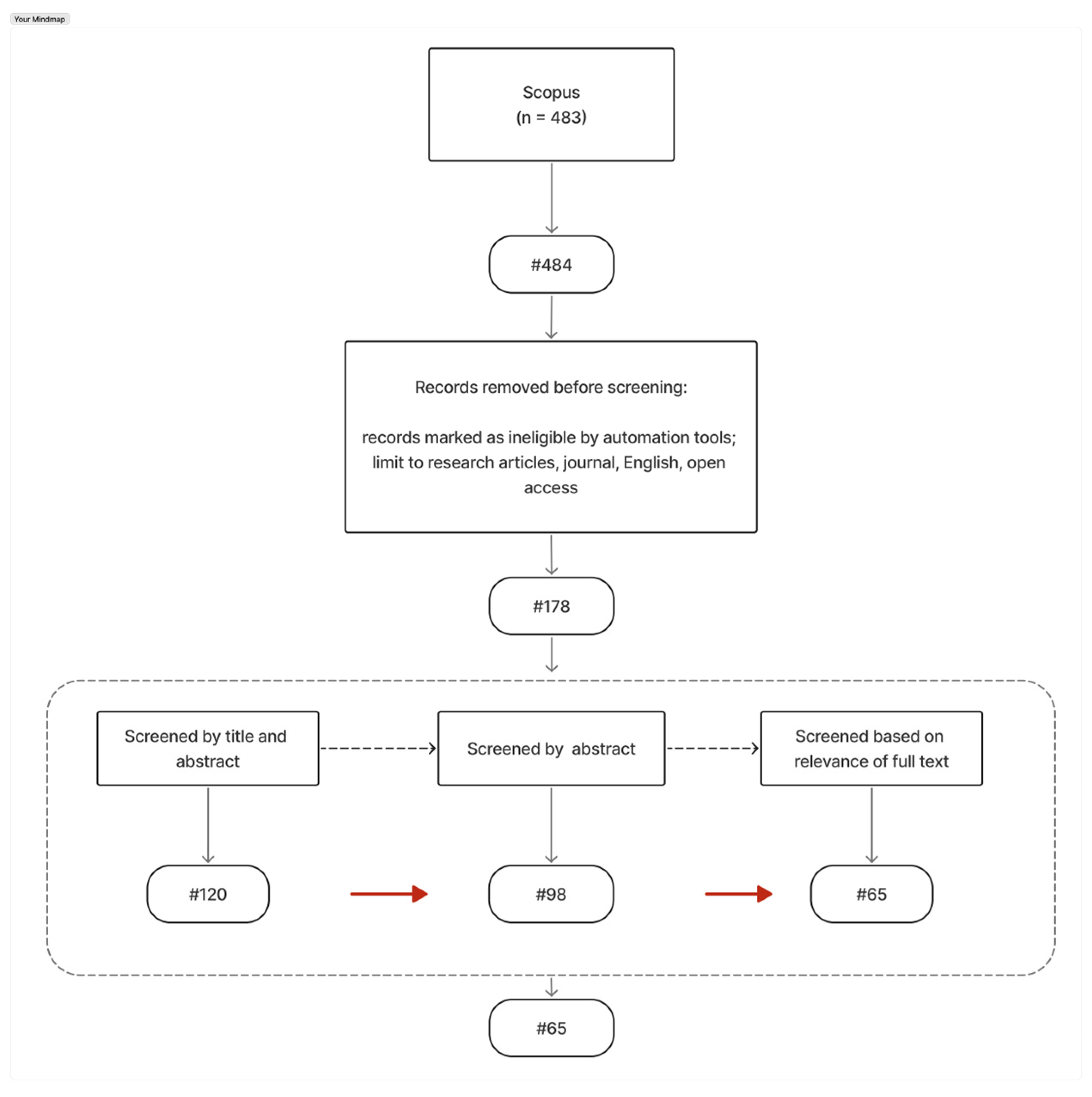
2. Literature Search
3. Results and Analysis
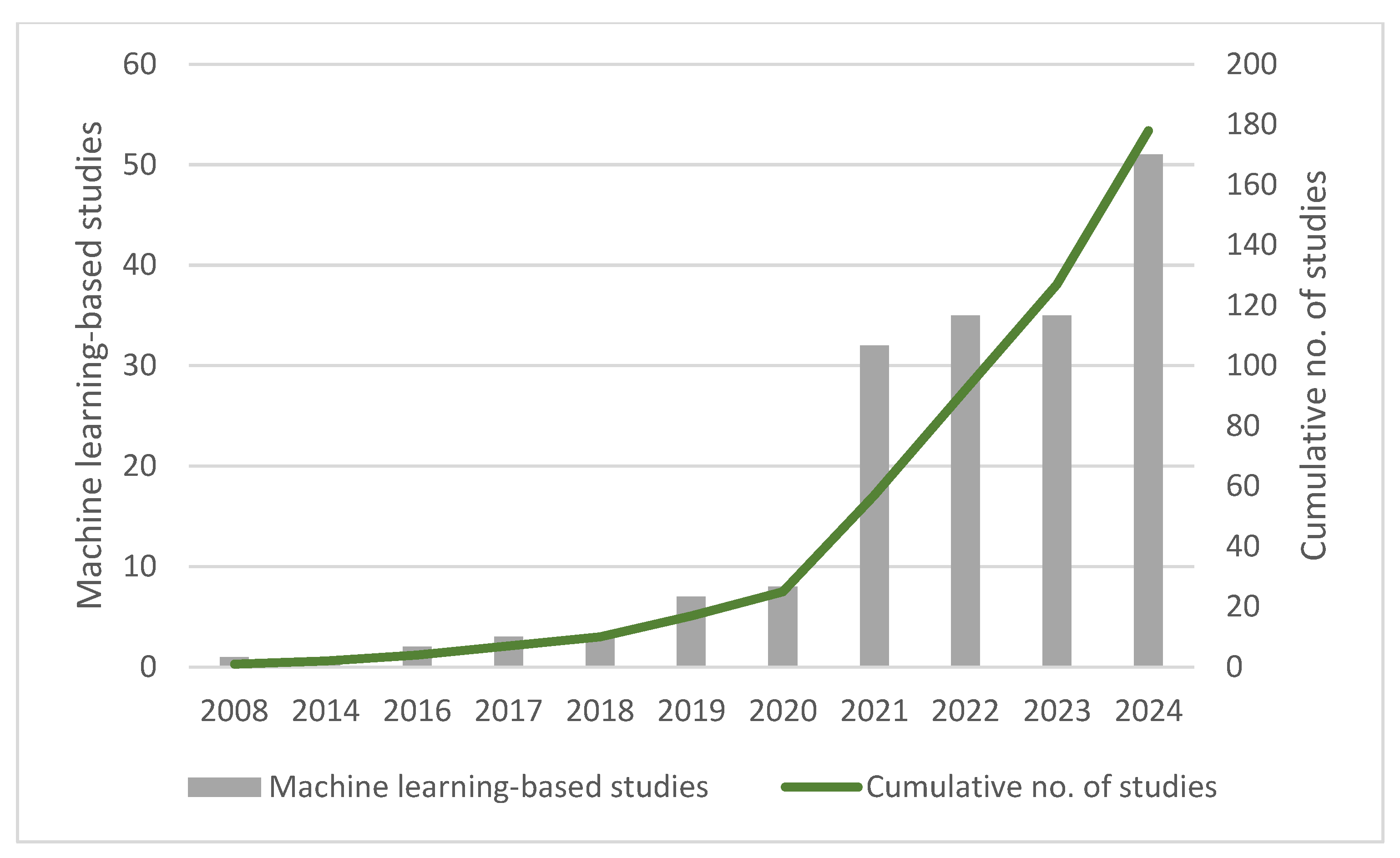
3.1. Publication Trends in Machine Learning and GDE Assessments
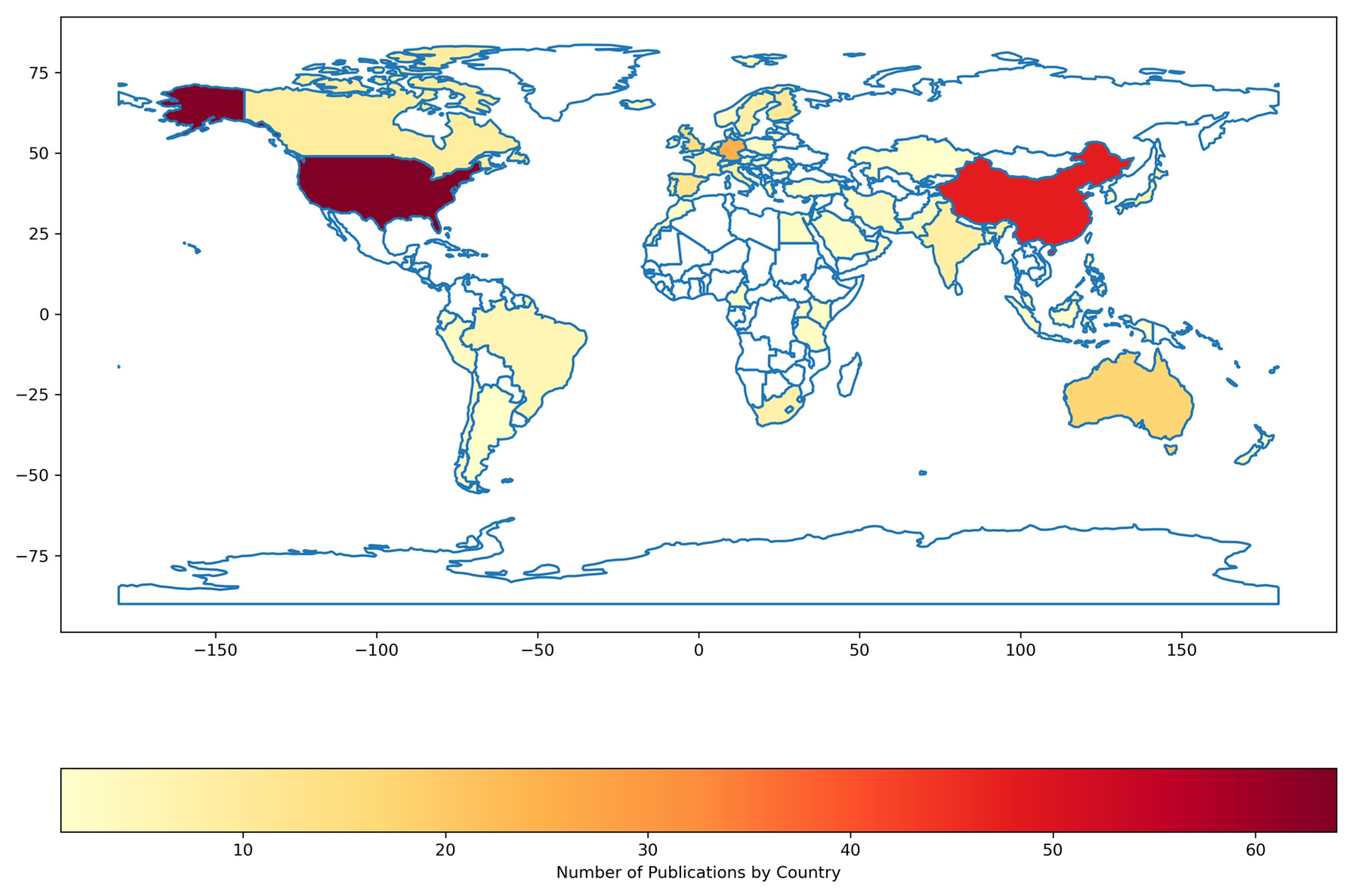
3.2. Geographical Trends of Machine Learning-Based Research on GDEs
4. Analytical Algorithms for Evaluating GDEs Using Remotely Sensed Data
5. Analysis of Machine Learning Algorithms for Detecting Groundwater-Dependent Ecosystems (GDEs) and Composition
6. Challenges in Determining a Suitable Machine Learning Model for GDE Detection and Vegetation Diversity Analysis
7. Application of Machine Learning Assessments of GDEs: Challenges and Recommendations
8. Conclusions
Author Contributions
Funding
Acknowledgments
Conflicts of Interest
References
- Al-Fugara, A.; Pourghasemi, H.R.; Al-Shabeeb, A.R.; Habib, M.; Al-Adamat, R.; Al-Amoush, H.; Collins, A.L. A comparison of machine learning models for the mapping of groundwater spring potential. Environ. Earth Sci. 2020, 79, 206. [Google Scholar] [CrossRef]
- Morsy, K.M.; Alenezi, A.; Alrukaibi, D.S. Groundwater and dependent ecosystems: Revealing the impacts of climate change. Int. J. Appl. Eng. Res. 2017, 12, 3919–3926. [Google Scholar]
- Nevill, J.C.; Hancock, P.J.; Murray, B.R.; Ponder, W.F.; Humphreys, W.F.; Phillips, M.L.; Groom, P.K. Groundwater-dependent ecosystems and the dangers of groundwater overdraft: A review and an Australian perspective. Pac. Conserv. Biol. 2010, 16, 187–208. [Google Scholar] [CrossRef]
- Dams, J.; Salvadore, E.; Van Daele, T.; Ntegeka, V.; Willems, P.; Batelaan, O. Spatio-temporal impact of climate change on the groundwater system. Hydrol. Earth Syst. Sci. 2012, 16, 1517–1531. [Google Scholar] [CrossRef]
- Essam, D.; Ahmed, M.; Abouelmagd, A.; Soliman, F. Monitoring temporal variations in groundwater levels in urban areas using ground penetrating radar. Sci. Total. Environ. 2020, 703, 134986. [Google Scholar] [CrossRef]
- Barbieri, M.; Barberio, M.D.; Banzato, F.; Billi, A.; Boschetti, T.; Franchini, S.; Gori, F.; Petitta, M. Climate change and its effect on groundwater quality. Environ. Geochem. Health 2021, 45, 1133–1144. [Google Scholar] [CrossRef]
- Wada, Y.; Van Beek, L.P.H.; Van Kempen, C.M.; Reckman, J.W.T.M.; Vasak, S.; Bierkens, M.F.P. Global depletion of groundwater resources. Geophys. Res. Lett. 2010, 37, L20402. [Google Scholar] [CrossRef]
- Eamus, D.; Froend, R.; Loomes, R.; Hose, G.; Murray, B. A functional methodology for determining the groundwater regime needed to maintain the health of groundwater-dependent vegetation. Aust. J. Bot. 2006, 54, 97–114. [Google Scholar] [CrossRef]
- Norton, R.K. Planning for resilient and sustainable coastal shorelands and communities in the face of global climate change. Oxf. Res. Encycl. Environ. Sci. 2022. [Google Scholar] [CrossRef]
- Baker, C.; Lawrence, R.; Montagne, C.; Patten, D. Mapping wetlands and riparian areas using Landsat ETM+ imagery and decision-tree-based models. Wetlands 2006, 26, 465–474. [Google Scholar] [CrossRef]
- Berhanu, M.; Suryabhagavan, K.V.; Korme, T. Wetland mapping and evaluating the impacts on hydrology, using geospatial techniques: A case of Geba Watershed, Southwest Ethiopia. Geol. Ecol. Landscapes 2021, 7, 293–310. [Google Scholar] [CrossRef]
- Kalbus, E.; Reinstorf, F.; Schirmer, M. Measuring methods for groundwater—Surface water interactions: A review. Hydrol. Earth Syst. Sci. 2006, 10, 873–887. [Google Scholar] [CrossRef]
- Doody, T.M.; Barron, O.V.; Dowsley, K.; Emelyanova, I.; Fawcett, J.; Overton, I.C.; Pritchard, J.L.; Van Dijk, A.I.; Warren, G. Continental mapping of groundwater dependent ecosystems: A methodological framework to integrate diverse data and expert opinion. J. Hydrol. Reg. Stud. 2017, 10, 61–81. [Google Scholar] [CrossRef]
- Jones, C.; Stanton, D.; Hamer, N.; Denner, S.; Singh, K.; Flook, S.; Dyring, M. Field investigation of potential terrestrial groundwater-dependent ecosystems within Australia’s Great Artesian Basin. Hydrogeol. J. 2020, 28, 237–261. [Google Scholar] [CrossRef]
- Bertrand, G.; Goldscheider, N.; Gobat, J.-M.; Hunkeler, D. Review: From multi-scale conceptualization to a classification system for inland groundwater-dependent ecosystems. Hydrogeol. J. 2012, 20, 5–25. [Google Scholar] [CrossRef]
- Bertrand, G.; Siergieiev, D.; Ala-Aho, P.; Rossi, P.M. Environmental tracers and indicators bringing together groundwater, surface water and groundwater-dependent ecosystems: Importance of scale in choosing relevant tools. Environ. Earth Sci. 2014, 72, 813–827. [Google Scholar] [CrossRef]
- Kløve, B.; Ala-Aho, P.; Bertrand, G.; Gurdak, J.J.; Kupfersberger, H.; Kværner, J.; Muotka, T.; Mykrä, H.; Preda, E.; Rossi, P.; et al. Climate change impacts on groundwater and dependent ecosystems. J. Hydrol. 2014, 518, 250–266. [Google Scholar] [CrossRef]
- Han, L.; He, D. Leafing intensity decreases with increasing water table depth and plant height in Populus euphratica, a desert riparian species. Acta Oecologica 2020, 109, 103672. [Google Scholar] [CrossRef]
- Hoyos, I.C.P.; Krakauer, N.Y.; Khanbilvardi, R.; Armstrong, R.A. A review of advances in the identification and characterization of groundwater dependent ecosystems using geospatial technologies. Geosciences 2016, 6, 17. [Google Scholar] [CrossRef]
- Orellana, F.; Verma, P.; Loheide II, S.P.; Daly, E. Monitoring and modeling water-vegetation interactions in groundwater-dependent ecosystems. Rev. Geophys. 2012, 50, 1–24. [Google Scholar] [CrossRef]
- Zhao, X.; Zhou, D.; Fang, J. Satellite-based Studies on Large-Scale Vegetation Changes in China. J. Integr. Plant Biol. 2012, 54, 713–728. [Google Scholar] [CrossRef] [PubMed]
- Eamus, D.; Zolfaghar, S.; Villalobos-Vega, R.; Cleverly, J.; Huete, A. Groundwater-dependent ecosystems: Recent insights from satellite and field-based studies. Hydrol. Earth Syst. Sci. 2015, 19, 4229–4256. [Google Scholar] [CrossRef]
- Chiloane, C.; Dube, T.; Shoko, C. Impacts of groundwater and climate variability on terrestrial groundwater dependent ecosystems: A review of geospatial assessment approaches and challenges and possible future research directions. Geocarto Int. 2021, 37, 6755–6779. [Google Scholar] [CrossRef]
- Chen, W. Major scientific issues on water demand studying for groundwater-dependent vegetation ecosystems in inland arid regions. Earth Sci. J. Earth Sci. China Univ. Geosci. 2014, 39, 1340–1348. [Google Scholar] [CrossRef]
- Kumar, L.; Mutanga, O. Google Earth Engine Applications Since Inception: Usage, Trends, and Potential. Remote Sens. 2018, 10, 1509. [Google Scholar] [CrossRef]
- Amani, M.; Ghorbanian, A.; Ahmadi, S.A.; Kakooei, M.; Moghimi, A.; Mirmazloumi, S.M.; Moghaddam, S.H.A.; Mahdavi, S.; Ghahremanloo, M.; Parsian, S.; et al. Google Earth Engine Cloud Computing Platform for Remote Sensing Big Data Applications: A Comprehensive Review. IEEE J. Sel. Top. Appl. Earth Obs. Remote Sens. 2020, 13, 5326–5350. [Google Scholar] [CrossRef]
- Zhou, B.; Okin, G.S.; Zhang, J. Leveraging Google Earth Engine (GEE) and machine learning algorithms to incorporate in situ measurement from different times for rangelands monitoring. Remote Sens. Environ. 2020, 236, 111521. [Google Scholar] [CrossRef]
- Horsley, T.; Dingwall, O.; Sampson, M. Checking reference lists to find additional studies for systematic reviews. Cochrane Database Syst. Rev. 2011, MR000026. [Google Scholar] [CrossRef]
- Moghaddam, D.D.; Rahmati, O.; Haghizadeh, A.; Kalantari, Z. A Modeling comparison of groundwater potential mapping in a mountain bedrock aquifer: QUEST, GARP, and RF models. Water 2020, 12, 679. [Google Scholar] [CrossRef]
- Rohde, M.M.; Biswas, T.; Housman, I.W.; Campbell, L.S.; Klausmeyer, K.R.; Howard, J.K. A machine learning approach to predict groundwater levels in California reveals ecosystems at risk. Front. Earth Sci. 2021, 9, 784499. [Google Scholar] [CrossRef]
- Balogun, A.-L.; Yekeen, S.T.; Pradhan, B.; Althuwaynee, O.F. Spatio-temporal analysis of oil spill impact and recovery pattern of coastal vegetation and wetland using multispectral satellite landsat 8-oli imagery and machine learning models. Remote Sens. 2020, 12, 1225. [Google Scholar] [CrossRef]
- Zhou, R.; Yang, C.; Li, E.; Cai, X.; Yang, J.; Xia, Y. Object-based wetland vegetation classification using multi-feature selection of unoccupied aerial vehicle RGB imagery. Remote Sens. 2021, 13, 4910. [Google Scholar] [CrossRef]
- Jafarzadeh, H.; Mahdianpari, M.; Gill, E.W.; Brisco, B.; Mohammadimanesh, F. Remote sensing and machine learning tools to support wetland monitoring: A meta-analysis of three decades of research. Remote Sens. 2022, 14, 6104. [Google Scholar] [CrossRef]
- Thessen, A. Adoption of machine learning techniques in ecology and earth science. One Ecosyst. 2016, 1, e8621. [Google Scholar] [CrossRef]
- Ghannam, R.B.; Techtmann, S.M. Machine learning applications in microbial ecology, human microbiome studies, and environmental monitoring. Comput. Struct. Biotechnol. J. 2021, 19, 1092–1107. [Google Scholar] [CrossRef]
- Tuia, D.; Kellenberger, B.; Beery, S.; Costelloe, B.R.; Zuffi, S.; Risse, B.; Mathis, A.; Mathis, M.W.; van Langevelde, F.; Burghardt, T.; et al. Perspectives in machine learning for wildlife conservation. Nat. Commun. 2022, 13, 792. [Google Scholar] [CrossRef]
- Dujon, A.; Schofield, G. Importance of machine learning for enhancing ecological studies using information-rich imagery. Endanger. Species Res. 2019, 39, 91–104. [Google Scholar] [CrossRef]
- Otoo, N.G.; Sutanudjaja, E.H.; van Vliet, M.T.H.; Schipper, A.M.; Bierkens, M.F.P. Mapping groundwater dependent ecosystems using a high-resolution global groundwater model. Hydrol. Earth Syst. Sci. Discuss. 2024. in review. [Google Scholar] [CrossRef]
- Howard, J.K.; Dooley, K.; Brauman, K.A.; Klausmeyer, K.R.; Rohde, M.M. Ecosystem services produced by groundwater dependent ecosystems: A framework and case study in California. Front. Water 2023, 5, 1115416. [Google Scholar] [CrossRef]
- Touré, H.; Boateng, C.D.; Gidigasu, S.S.; Wemegah, D.D.; Mensah, V.; Aryee, J.N.; Osei, M.A.; Gilbert, J.; Afful, S.K. A review of geological and climatic variables in groundwater availability prediction in Africa: Machine learning approaches. EarthArXiv eprints 2024. [Google Scholar] [CrossRef]
- Gaffoor, Z.; Pietersen, K.; Jovanovic, N.; Bagula, A.; Kanyerere, T. Big data analytics and its role to support groundwater management in the southern African development community. Water 2020, 12, 2796. [Google Scholar] [CrossRef]
- Brkić, Ž.; Kuhta, M.; Larva, O.; Gottstein, S. Groundwater and connected ecosystems: An overview of groundwater body status assessment in Croatia. Environ. Sci. Eur. 2019, 31, 75. [Google Scholar] [CrossRef]
- Pazola, A.; Shamsudduha, M.; French, J.; MacDonald, A.M.; Abiye, T.; Goni, I.B.; Taylor, R.G. High-resolution long-term average groundwater recharge in Africa estimated using random forest regression and residual interpolation. Hydrol. Earth Syst. Sci. 2023, 28, 2949–2967. [Google Scholar] [CrossRef]
- Mensah, V.; Boateng, C.D.; Gidigasu, S.S.; Wemegah, D.D.; Aryee, J.N.; Osei, M.A.; Touré, H.; Gilbert, J.; Afful, S.K. Groundwater exploration methods in west africa: A review. EarthArXiv eprints 2024. [Google Scholar] [CrossRef]
- Muhury, N.; Apan, A.A.; Marasani, T.N.; Ayele, G.T. Modelling floodplain vegetation response to groundwater variability using the ArcSWAT hydrological model, MODIS NDVI data, and machine learning. Land 2022, 11, 2154. [Google Scholar] [CrossRef]
- Rohde, M.M.; Sweet, S.B.; Ulrich, C.; Howard, J. A Transdisciplinary approach to characterize hydrological controls on groundwater-dependent ecosystem health. Front. Environ. Sci. 2019, 7, 175. [Google Scholar] [CrossRef]
- Maskooni, E.K.; Naghibi, S.A.; Hashemi, H.; Berndtsson, R. Application of advanced machine learning algorithms to assess groundwater potential using remote sensing-derived data. Remote Sens. 2020, 12, 2742. [Google Scholar] [CrossRef]
- Pedzisai, E.; Mutanga, O.; Odindi, J.; Mushore, T.D. The use of remote sensing indices to understand flood-recharged soil moisture impacts on trees in semi-arid floodplains: A review. Ecohydrology 2022, 15, e2460. [Google Scholar] [CrossRef]
- Werstak, C.E.; Housman, I.; Maus, P.; Fisk, H.; Gurrieri, J.; Carlson, C.P.; Johnston, B.C.; Stratton, B.; Hurja, J.C. Groundwater-Dependent Ecosystem Inventory Using Remote Sensing; RSAC-10011-RPT1; U.S. Department of Agriculture, Forest Service, Remote Sensing Applications Center: Washington, DC, USA, 2012. [Google Scholar]
- Fitoka, E.; Tompoulidou, M.; Hatziiordanou, L.; Apostolakis, A.; Höfer, R.; Weise, K.; Ververis, C. Water-related ecosystems’ mapping and assessment based on remote sensing techniques and geospatial analysis: The SWOS national service case of the Greek Ramsar sites and their catchments. Remote Sens. Environ. 2020, 245, 111795. [Google Scholar] [CrossRef]
- Ismail, M.H. Evaluating supervised and unsupervised techniques for land cover mapping using remote sensing data. Geogr. Malays. J. Soc. Space 2009, 5, 1–10. [Google Scholar]
- Gxokwe, S.; Dube, T.; Mazvimavi, D. Leveraging Google Earth Engine platform to characterize and map small seasonal wetlands in the semi-arid environments of South Africa. Sci. Total. Environ. 2022, 803, 150139. [Google Scholar] [CrossRef] [PubMed]
- Nguyen, U.; Glenn, E.P.; Dang, T.D.; Pham, L.T. Mapping vegetation types in semi-arid riparian regions using random forest and object-based image approach: A case study of the Colorado River Ecosystem, Grand Canyon, Arizona. Ecol. Informatics 2019, 50, 43–50. [Google Scholar] [CrossRef]
- Dlikilili, S. Investigating the Groundwater Dependence and Response To Rainfall Variability of Vegetation in the Touws River and Catchment Using; University of the Western Cape: Cape Town, South Africa, 2019. [Google Scholar]
- Dronova, I. Object-Based Image Analysis in Wetland Research: A Review. Remote Sens. 2015, 7, 6380–6413. [Google Scholar] [CrossRef]
- Gxokwe, S.; Dube, T.; Mazvimavi, D.; Grenfell, M. Using cloud computing techniques to monitor long-term variations in ecohydrological dynamics of small seasonally-flooded wetlands in semi-arid South Africa. J. Hydrol. 2022, 612, 128080. [Google Scholar] [CrossRef]
- Liu, H.-H. Impact of climate change on groundwater recharge in dry areas: An ecohydrology approach. J. Hydrol. 2011, 407, 175–183. [Google Scholar] [CrossRef]
- Vizzari, M.; Lesti, G.; Acharki, S. Crop classification in Google Earth Engine: Leveraging Sentinel-1, Sentinel-2, European CAP data, and object-based machine-learning approaches. Geo-Spat. Inf. Sci. 2024, 1–16. [Google Scholar] [CrossRef]
- Guirado, E.; Blanco-Sacristán, J.; Rigol-Sánchez, J.P.; Alcaraz-Segura, D.; Cabello, J. A Multi-Temporal Object-Based Image Analysis to Detect Long-Lived Shrub Cover Changes in Drylands. Remote Sens. 2019, 11, 2649. [Google Scholar] [CrossRef]
- Zhu, X.; Chen, J.; Gao, F.; Chen, X.; Masek, J.G. An enhanced spatial and temporal adaptive reflectance fusion model for complex heterogeneous regions. Remote Sens. Environ. 2010, 114, 2610–2623. [Google Scholar] [CrossRef]
- Massey, R.; Sankey, T.T.; Yadav, K.; Congalton, R.G.; Tilton, J.C. Integrating cloud-based workflows in continental-scale cropland extent classification. Remote Sens. Environ. 2018, 219, 162–179. [Google Scholar] [CrossRef]
- Duro, D.C.; Franklin, S.E.; Dubé, M.G. Multi-scale object-based image analysis and feature selection of multi-sensor earth observation imagery using random forests. Int. J. Remote Sens. 2011, 33, 4502–4526. [Google Scholar] [CrossRef]
- Liu, D.; Xia, F. Assessing object-based classification: Advantages and limitations. Remote Sens. Lett. 2010, 1, 187–194. [Google Scholar] [CrossRef]
- Liu, Z.; Peng, C.; Work, T.; Candau, J.-N.; DesRochers, A.; Kneeshaw, D. Application of machine-learning methods in forest ecology: Recent progress and future challenges. Environ. Rev. 2018, 26, 339–350. [Google Scholar] [CrossRef]
- Huang, L.; Liu, Y.; Huang, W.; Dong, Y.; Ma, H.; Wu, K.; Guo, A. Combining Random Forest and XGBoost Methods in Detecting Early and Mid-Term Winter Wheat Stripe Rust Using Canopy Level Hyperspectral Measurements. Agriculture 2022, 12, 74. [Google Scholar] [CrossRef]
- Lucas, T.C.D. A translucent box: Interpretable machine learning in ecology. Ecol. Monogr. 2020, 90, e01422. [Google Scholar] [CrossRef]
- Perry, G.L.W.; Seidl, R.; Bellvé, A.M.; Rammer, W. An outlook for deep learning in ecosystem science. Ecosystems 2022, 25, 1700–1718. [Google Scholar] [CrossRef]
- Ahlawat, A.; Roy, A. Assessing the vulnerability of western Himalayan ecosystem to climate change using machine learning algorithms. In Proceedings of the Remote Sensing for Agriculture, Ecosystems, and Hydrology XXV, Amsterdam, The Netherlands, 3–7 September 2023; pp. 15–95. [Google Scholar]
- Ji, P.; Su, R.; Wu, G.; Xue, L.; Zhang, Z.; Fang, H.; Zhang, D. Projecting Future Wetland Dynamics Under Climate Change and Land Use Pressure: A Machine Learning Approach Using Remote Sensing and Markov Chain Modeling. Remote Sens. 2025, 17, 1089. [Google Scholar] [CrossRef]
- Bayat, M.; Burkhart, H.; Namiranian, M.; Hamidi, S.K.; Heidari, S.; Hassani, M. Assessing biotic and abiotic effects on biodiversity index using machine learning. Forests 2021, 12, 461. [Google Scholar] [CrossRef]
- Simon, S.M.; Glaum, P.; Valdovinos, F.S. Interpreting random forest analysis of ecological models to move from prediction to explanation. Sci. Rep. 2023, 13, 3881. [Google Scholar] [CrossRef]
- Gurung, N.; Gazi, S.; Islam, Z. Strategic employee performance analysis in the USA: Deploying machine learning algorithms intelligently. J. Bus. Manag. Stud. 2024, 6, 1–14. [Google Scholar] [CrossRef]
- Jordan, M.I.; Mitchell, T.M. Machine learning: Trends, perspectives, and prospects. Science 2015, 349, 255–260. [Google Scholar] [CrossRef]
- Tulbure, M.G.; Broich, M.; Stehman, S.V.; Kommareddy, A. Surface water extent dynamics from three decades of seasonally continuous Landsat time series at subcontinental scale in a semi-arid region. Remote Sens. Environ. 2016, 178, 142–157. [Google Scholar] [CrossRef]
- Ahangarha, M.; Seydi, S.T.; Shahhoseini, R. Hyperspectral change detection in wetland and water-body areas based on machine learning. ISPRS Int. Arch. Photogramm. Remote Sens. Spat. Inf. Sci. 2019, 42, 19–24. [Google Scholar] [CrossRef]
- El-Hokayem, L.; De Vita, P.; Usman, M.; Link, A.; Conrad, C. Mapping potentially groundwater-dependent vegetation in the Mediterranean biome using global geodata targeting site conditions and vegetation characteristics. Sci. Total. Environ. 2023, 898, 166397. [Google Scholar] [CrossRef]
- Weise, K.; Höfer, R.; Franke, J.; Guelmami, A.; Simonson, W.; Muro, J.; O’connor, B.; Strauch, A.; Flink, S.; Eberle, J.; et al. Wetland extent tools for SDG 6.6.1 reporting from the Satellite-based Wetland Observation Service (SWOS). Remote Sens. Environ. 2020, 247, 111892. [Google Scholar] [CrossRef]
- Araya-López, R.A.; Lopatin, J.; Fassnacht, F.E.; Hernández, H.J. Monitoring Andean high altitude wetlands in central Chile with seasonal optical data: A comparison between Worldview-2 and Sentinel-2 imagery. ISPRS J. Photogramm. Remote Sens. 2018, 145, 213–224. [Google Scholar] [CrossRef]
- Snyder, S.D.; Loftin, C.S.; Reeve, A.S. Predicting the Presence of Groundwater-Influenced Ecosystems in the Northeastern United States with Ensembled Models. Water 2023, 15, 4035. [Google Scholar] [CrossRef]
- Adam, E.; Mureriwa, N.; Newete, S. Mapping Prosopis glandulosa (mesquite) in the semi-arid environment of South Africa using high-resolution WorldView-2 imagery and machine learning classifiers. J. Arid. Environ. 2017, 145, 43–51. [Google Scholar] [CrossRef]
- Mpakairi, K.S.; Dube, T.; Dondofema, F.; Dalu, T. Spatio–temporal variation of vegetation heterogeneity in groundwater dependent ecosystems within arid environments. Ecol. Informatics 2022, 69, 101667. [Google Scholar] [CrossRef]
- Arvor, D.; Daher, F.R.; Briand, D.; Dufour, S.; Rollet, A.-J.; Simões, M.; Ferraz, R.P. Monitoring thirty years of small water reservoirs proliferation in the southern Brazilian Amazon with Landsat time series. ISPRS J. Photogramm. Remote Sens. 2018, 145, 225–237. [Google Scholar] [CrossRef]
- Higgisson, W.; Cobb, A.; Tschierschke, A.; Dyer, F. Estimating the cover of Phragmites australis using unmanned aerial vehicles and neural networks in a semi-arid wetland. River Res. Appl. 2021, 37, 1312–1322. [Google Scholar] [CrossRef]
- Mpakairi, K.S.; Dube, T.; Dondofema, F.; Dalu, T. Spatial Characterisation of Vegetation Diversity in Groundwater-Dependent Ecosystems Using In-Situ and Sentinel-2 MSI Satellite Data. Remote Sens. 2022, 14, 2995. [Google Scholar] [CrossRef]
- Eckersley, J.; Moore, C.E.; Thompson, S.E.; Renton, M.; Grierson, P.F. Separating leaf area index from plant area index using semi-supervised classification of digital hemispheric canopy photographs: A case study of dryland vegetation. Agric. For. Meteorol. 2025, 363, 110395. [Google Scholar] [CrossRef]
- Saha, T.K.; Pal, S.; Sarkar, R. Prediction of wetland area and depth using linear regression model and artificial neural network based cellular automata. Ecol. Inform. 2021, 62, 101272. [Google Scholar] [CrossRef]
- Li, A.; Fan, M.; Qin, G.; Xu, Y.; Wang, H. comparative analysis of machine learning algorithms in automatic identification and extraction of water boundaries. Appl. Sci. 2021, 11, 10062. [Google Scholar] [CrossRef]
- Lu, Q.; Si, W.; Wei, L.; Li, Z.; Xia, Z.; Ye, S.; Xia, Y. Retrieval of water quality from UAV-borne hyperspectral imagery: A comparative study of machine learning algorithms. Remote Sens. 2021, 13, 3928. [Google Scholar] [CrossRef]
- Kossieris, S.; Asgarimehr, M.; Wickert, J. Unsupervised machine learning for GNSS reflectometry inland water body detection. Remote Sens. 2023, 15, 3206. [Google Scholar] [CrossRef]
- Ulfa, A.; Kusuma, F.B.; Suardana, A.A.M.A.P.; Asriningrum, W.; Ibrahim, A.; Fadlillah, L.N. Detection of water-body boundaries from sentinel-2 imagery for floodplain lakes. Int. J. Remote Sens. Earth Sci. 2023, 19, 119–132. [Google Scholar] [CrossRef]
- Ming, L.; Liu, J.; Quan, Y.; Li, M.; Wang, B.; Wei, G. Mapping tree species diversity in a typical natural secondary forest by combining multispectral and LiDAR data. Ecol. Indic. 2024, 159, 111711. [Google Scholar] [CrossRef]
- Peng, C.; Xie, Z.; Jin, X. Using ensemble learning for remote sensing inversion of water quality parameters in poyang lake. Sustainability 2024, 16, 3355. [Google Scholar] [CrossRef]
- Nguyen, P.T.; Ha, D.H.; Jaafari, A.; Nguyen, H.D.; Van Phong, T.; Al-Ansari, N.; Prakash, I.; Van Le, H.; Pham, B.T. Groundwater potential mapping combining artificial neural network and real adaboost ensemble technique: The DakNong province case-study, Vietnam. Int. J. Environ. Res. Public Health 2020, 17, 2473. [Google Scholar] [CrossRef]
- Chen, C.; He, W.; Zhou, H.; Xue, Y.; Zhu, M. A comparative study among machine learning and numerical models for simulating groundwater dynamics in the Heihe River Basin, northwestern China. Sci. Rep. 2020, 10, 3904. [Google Scholar] [CrossRef] [PubMed]
- Rodríguez-López, L.; Usta, D.B.; Alvarez, L.B.; Duran-Llacer, I.; Lami, A.; Martínez-Retureta, R.; Urrutia, R. Machine learning algorithms for the estimation of water quality parameters in lake Llanquihue in southern Chile. Water 2023, 15, 1994. [Google Scholar] [CrossRef]
- Rincon-Flores, E.G.; Castano, L.; Solis, S.L.G.; Lopez, O.O.; Hernández, C.F.R.; Lara, L.A.C.; Valdés, L.P.A. Improving the learning-teaching process through adaptive learning strategy. Smart Learn. Environ. 2024, 11, 27. [Google Scholar] [CrossRef]
- Al-Adhaileh, M.H.; Alsaade, F.W. Modelling and Prediction of Water Quality by Using Artificial Intelligence. Sustainability 2021, 13, 4259. [Google Scholar] [CrossRef]
- del Castillo, A.F.; Yebra-Montes, C.; Garibay, M.V.; de Anda, J.; Garcia-Gonzalez, A.; Gradilla-Hernández, M.S. Simple prediction of an ecosystem-specific water quality index and the water quality classification of a highly polluted river through supervised machine learning. Water 2022, 14, 1235. [Google Scholar] [CrossRef]
- DeLancey, E.R.; Kariyeva, J.; Bried, J.T.; Hird, J.N. Large-scale probabilistic identification of boreal peatlands using Google Earth Engine, open-access satellite data, and machine learning. PLoS ONE 2019, 14, e0218165. [Google Scholar] [CrossRef]
- DeLancey, E.R.; Brisco, B.; McLeod, L.J.T.; Hedley, R.; Bayne, E.M.; Murnaghan, K.; Gregory, F.; Kariyeva, J. Modelling, Characterizing, and Monitoring Boreal Forest Wetland Bird Habitat with RADARSAT-2 and Landsat-8 Data. Water 2021, 13, 2327. [Google Scholar] [CrossRef]
- Jamali, A.; Mahdianpari, M.; Mohammadimanesh, F.; Brisco, B.; Salehi, B. A synergic use of sentinel-1 and sentinel-2 imagery for complex wetland classification using generative adversarial network (GAN) scheme. Water 2021, 13, 3601. [Google Scholar] [CrossRef]
- Jamali, A.; Mahdianpari, M. Swin transformer for complex coastal wetland classification using the integration of sentinel-1 and sentinel-2 imagery. Water 2022, 14, 178. [Google Scholar] [CrossRef]
- Shanthini, S.; Devi, M.S.; Grace, R.S. A comprehensive review of learning rules and architecture of perceptron in artificial neural networks (ANNs). Deep. Learn. Eng. Energy Financ. 2024, 115–163. [Google Scholar]
- Shashank, Y.; Amith, S.; Sahana, S.; Sastry, A. Monitoring of water quality using machine learning—A review. Int. J. Res. Appl. Sci. Eng. Technol. 2024, 12, 495–498. [Google Scholar] [CrossRef]
- Zhao, W.L.; Gentine, P.; Reichstein, M.; Zhang, Y.; Zhou, S.; Wen, Y.; Lin, C.; Li, X.; Qiu, G.Y. Physics-constrained machine learning of evapotranspiration. Geophys. Res. Lett. 2019, 46, 14496–14507. [Google Scholar] [CrossRef]
- Raman, R.; Das, A.; Manna, R.; Sahu, S.; Das, B. Physicochemical habitat traits preferred by small indigenous fish (chanda nama) in indian river discerning through machine learning. Environ. Sci. Pollut. Res. 2021, 30, 16499–16509. [Google Scholar] [CrossRef]
- Wen, L.; Hughes, M. Coastal wetland mapping using ensemble learning algorithms: A comparative study of bagging, boosting and stacking techniques. Remote Sens. 2020, 12, 1683. [Google Scholar] [CrossRef]
- Du, L.; McCarty, G.W.; Zhang, X.; Lang, M.W.; Vanderhoof, M.K.; Li, X.; Huang, C.; Lee, S.; Zou, Z. Mapping forested wetland inundation in the delmarva peninsula, USA using deep convolutional neural networks. Remote Sens. 2020, 12, 644. [Google Scholar] [CrossRef]
- Marjani, M.; Mahdianpari, M.; Mohammadimanesh, F.; Gill, E.W. CVTNet: A fusion of convolutional neural networks and vision transformer for wetland mapping using sentinel-1 and sentinel-2 satellite data. Remote Sens. 2024, 16, 2427. [Google Scholar] [CrossRef]
- Soulard, C.E.; Walker, J.J.; Smith, B.W.; Kreitler, J. The feasibility of using national-scale datasets for classifying wetlands in Arizona with machine learning. Earth Surf. Process. Landforms 2024, 49, 4632–4649. [Google Scholar] [CrossRef]
- Nguyen, D.P.; Ha, H.D.; Trinh, N.T.; Nguyen, M.T. Application of artificial intelligence for forecasting surface quality index of irrigation systems in the Red River Delta, Vietnam. Environ. Syst. Res. 2023, 12, 24. [Google Scholar] [CrossRef]

| Factor | Artificial Neural Networks | Decision Trees | Random Forest | Gradient Tree Boosting | Support Vector Machines | Naïve Bayes |
|---|---|---|---|---|---|---|
| Type | Connectionist, deep learning | Tree-based | Ensemble (bagging) | Ensemble (boosting) | Kernel-based, geometric | Probabilistic |
| Computational Cost | High (especially deep models) | Low to moderate | Moderate | High | Moderate to high (with kernels) | Very low |
| Interpretability | Low (black box) | High (easy to understand) | Moderate (harder than DTs) | Low (complex ensemble) | Moderate (difficult in high dimensions) | High (simple probability outputs) |
| Feature Engineering | Minimal (automatically learns features) | Requires manual feature selection | Minimal | Minimal | Requires feature scaling and selection | Requires independent features |
| Performance on Small Data | Poor (needs large datasets) | Good | Good | Moderate to good | Good (especially with kernels) | Excellent |
| Overfitting Tendency | High (needs regularization) | High (prone to deep trees overfitting) | Low (averages multiple trees) | Moderate (regularization needed) | Low to moderate | Low |
| Training Time | Long (especially deep models) | Fast | Moderate | Slow (especially with many trees) | Slow (with large datasets and complex kernels) | Very fast |
| Generalization Ability | High (with enough data) | Moderate (depends on pruning) | High | High | High | Moderate |
| Scalability | High (with GPUs) | High (for small data, poor for big data) | High (parallel processing) | Moderate to high | Poor for very large datasets | High |
| Best Use Cases | Species distribution modelling, remote sensing, habitat classification | Simple environmental impact assessments, rule-based ecological models | Biodiversity assessment, species–habitat relationships, ecological risk assessment | Climate change impact modelling, habitat suitability prediction, species population dynamics | Pollution impact studies, land cover classification, ecological niche modelling | Rapid classification of species, early-warning ecological assessments |
| GDE Type | Purpose | Model Performance | Key Findings | Citation/Country |
|---|---|---|---|---|
| Wetland | Monitoring small seasonal wetlands using Google Earth Engine & ML algorithms. | RF: 68.8–80.55%, SVM: 66.60–62.29%, CART: 62.30–75.00%, NB: 29.50–25.00% | RF performed best, while NB had the lowest accuracy. | [52] |
| Wetland | Automated wetland and water body monitoring using hyperspectral images. | RF: 93.33% (Kappa: 0.811) | High accuracy achieved with hyperspectral data. | [75] |
| Wetland | Developing a wetland observation service using Sentinel-2 data. | OA > 91% for different wetland classes | High accuracy for mapping lakes, rivers, estuaries, and vegetated wetlands. | [77] |
| Wetland | Comparing WorldView-2 & Sentinel-2 data for wetland monitoring. | BSVM: OA > 78%, Soil moisture (r = 0.58, NMSE = 19%) | Soil moisture estimation feasible with optical remote sensing. | [78] |
| Wetland | Mapping wetlands and riparian areas using Landsat ETM+ & decision trees. | Classification Tree: OA 73.1%, SGB: OA 86% | SGB improved classification performance over traditional decision trees. | [10] |
| Vegetation | Mapping pGDV in Mediterranean Biome | RF:86.7% (Kappa: 0.76) | RF outperformed the AHP, which overestimated pGDV | [76] |
| Vegetation | Predict groundwater influenced ecosystems using ensembled models | (GLM, GAM, MaxEnt, Random Forest). RF: AUC = 81% | Modelled wetland and surface water GDEs in two distinct ecoregions. | [79] |
| Vegetation | Mapping Prosopis glandulosa in a semi-arid environment. | RF: 86.59% (Kappa: 0.84), SVM: 85.98% (Kappa: 0.83) | Spectral confusion led to lower producer’s accuracies for some species. | [80] |
| Vegetation | Spatio-temporal variation of vegetation heterogeneity in arid GDEs. | RF (Shannon–Weiner Index): MAE = 30.37, RMSE = 33.25, %RMSE = 63.94 | RF models explained environmental drivers affecting heterogeneity. | [81] |
| Surface Water | Surface water extent analysis over three decades using Landsat data. | RF: OA 99.9%, Producer’s Accuracy: 87%, User’s Accuracy: 96% | Accuracy increased with newer sensors but was lower in wet years. | [74] |
| Surface Water | 30 years of monitoring small water bodies using Landsat datasets. | OA: 0.872, Kappa: 0.745 | Spatial resolution limited detection of very small water bodies. | [82] |
| Vegetation & Surface Water | Estimating Phragmites australis cover using UAVs and neural networks. | CNN: OA 94.7%, F-score: 0.945 | High accuracy (>98%) for reeds, leaf litter, and trash; lowest for bare ground (41%). | [83] |
| Springs | Mapping groundwater spring potential with ML models. | RF: 80.6%, SVM: 80.2%, MDA: 83.2%, BRT: 78.0%, MARS: 75.5% | MDA had the highest accuracy, while BRT handled missing data well. | [1] |
| Springs | Comparing robustness of models for groundwater spring potential. | Linear Model Tree: AUC-ROC 0.9, C4.5 Decision Tree: AUC-ROC 0.831, SVM: AUC-ROC 0.889 | Linear Model Tree was sensitive to input data changes. | [29] |
| Phreatophytes | Accuracy assessment of OBIA & Mask R-CNN segmentation in drylands. | Fusion of OBIA & Mask R-CNN improved accuracy by 25% | Combined methods were more effective for vegetation segmentation. | [59] |
| Phreatophytes | Explored environmental drivers affecting vegetation heterogeneity. | RF models explained environmental drivers affecting heterogeneity | RF models provided insights into environmental drivers. | [84] |
Disclaimer/Publisher’s Note: The statements, opinions and data contained in all publications are solely those of the individual author(s) and contributor(s) and not of MDPI and/or the editor(s). MDPI and/or the editor(s) disclaim responsibility for any injury to people or property resulting from any ideas, methods, instructions or products referred to in the content. |
© 2025 by the authors. Licensee MDPI, Basel, Switzerland. This article is an open access article distributed under the terms and conditions of the Creative Commons Attribution (CC BY) license (https://creativecommons.org/licenses/by/4.0/).
Share and Cite
Chiloane, C.N.; Dube, T.; Sibanda, M.; Dalu, T.; Shoko, C. A Summary of Recent Advances in the Literature on Machine Learning Techniques for Remote Sensing of Groundwater Dependent Ecosystems (GDEs) from Space. Remote Sens. 2025, 17, 1460. https://doi.org/10.3390/rs17081460
Chiloane CN, Dube T, Sibanda M, Dalu T, Shoko C. A Summary of Recent Advances in the Literature on Machine Learning Techniques for Remote Sensing of Groundwater Dependent Ecosystems (GDEs) from Space. Remote Sensing. 2025; 17(8):1460. https://doi.org/10.3390/rs17081460
Chicago/Turabian StyleChiloane, Chantel Nthabiseng, Timothy Dube, Mbulisi Sibanda, Tatenda Dalu, and Cletah Shoko. 2025. "A Summary of Recent Advances in the Literature on Machine Learning Techniques for Remote Sensing of Groundwater Dependent Ecosystems (GDEs) from Space" Remote Sensing 17, no. 8: 1460. https://doi.org/10.3390/rs17081460
APA StyleChiloane, C. N., Dube, T., Sibanda, M., Dalu, T., & Shoko, C. (2025). A Summary of Recent Advances in the Literature on Machine Learning Techniques for Remote Sensing of Groundwater Dependent Ecosystems (GDEs) from Space. Remote Sensing, 17(8), 1460. https://doi.org/10.3390/rs17081460