


Rapid Response to Effusive Eruptions Using Satellite Infrared Data: The March 2024 Eruption of Fernandina (Galápagos)

 ,
,  , , , and
Abstract
1. Introduction
2. Materials and Methods
2.1. Study Area: Fernandina Volcano

2.2. Sensors
2.2.1. Moderate Resolution MIR-TIR Sensors (0.375–1 km)
2.2.2. High-Resolution SWIR-TIR Sensors (20–100 m)
2.2.3. Very High-Resolution VNIR Sensors (<10 m)
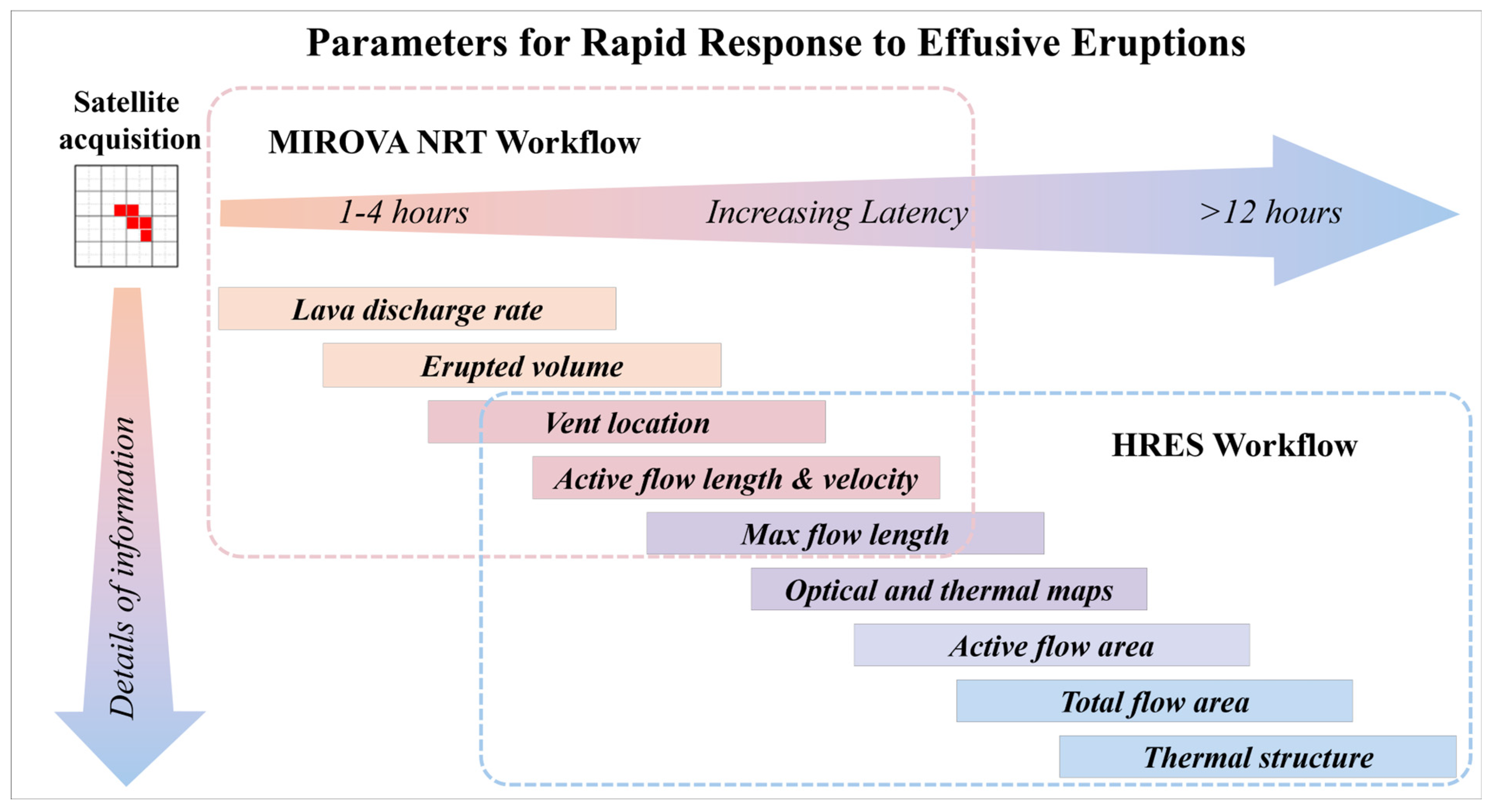
2.3. Workflows and Parameters
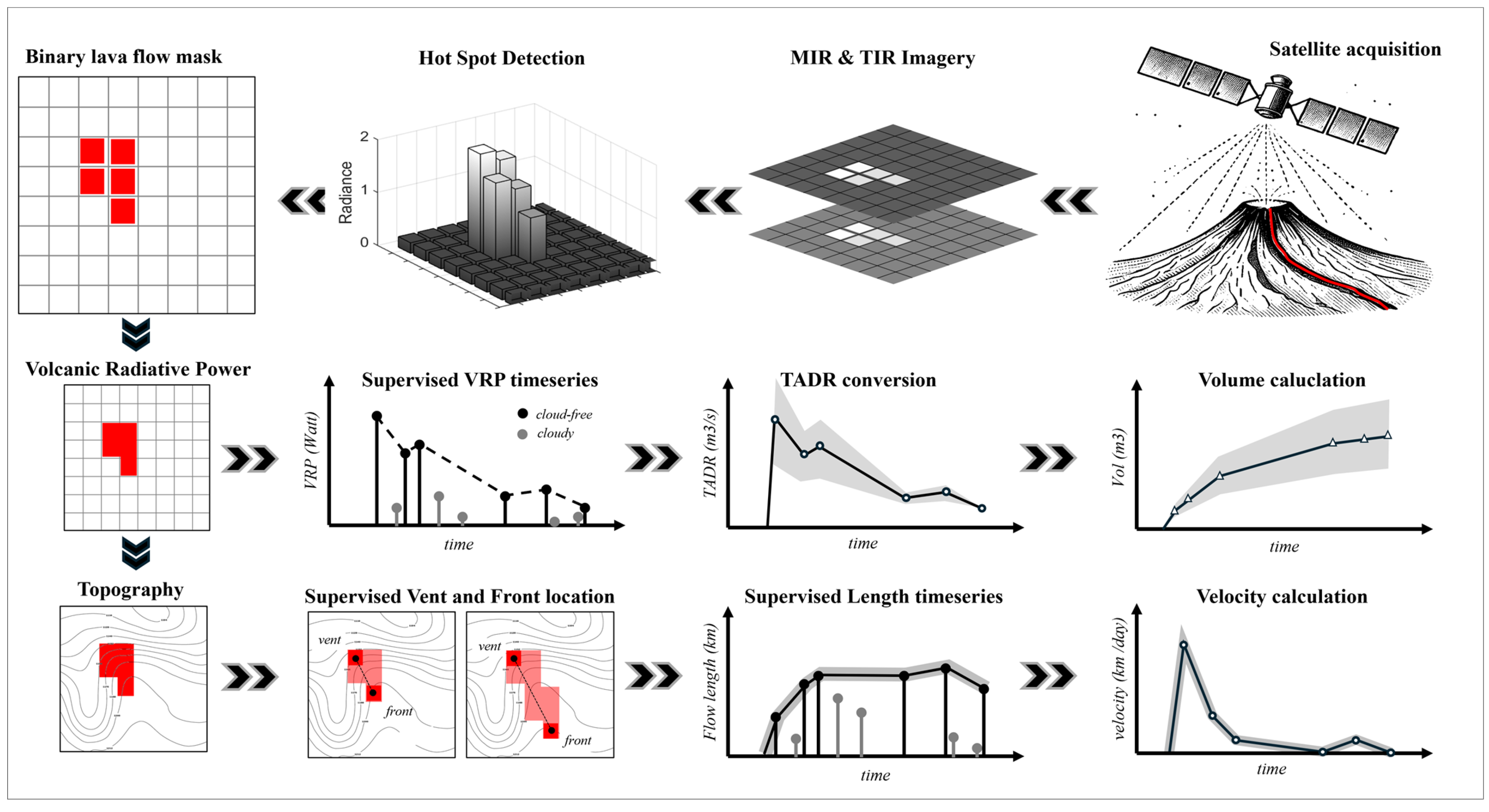
2.3.1. MIROVA NRT Workflow (Moderate Resolution MIR and TIR Data)
2.3.2. HRES Workflow (High- to Very High-Resolution VNIR-SWIR-TIR Data)
3. Results: NRT Products for Rapid Response and Situational Awareness
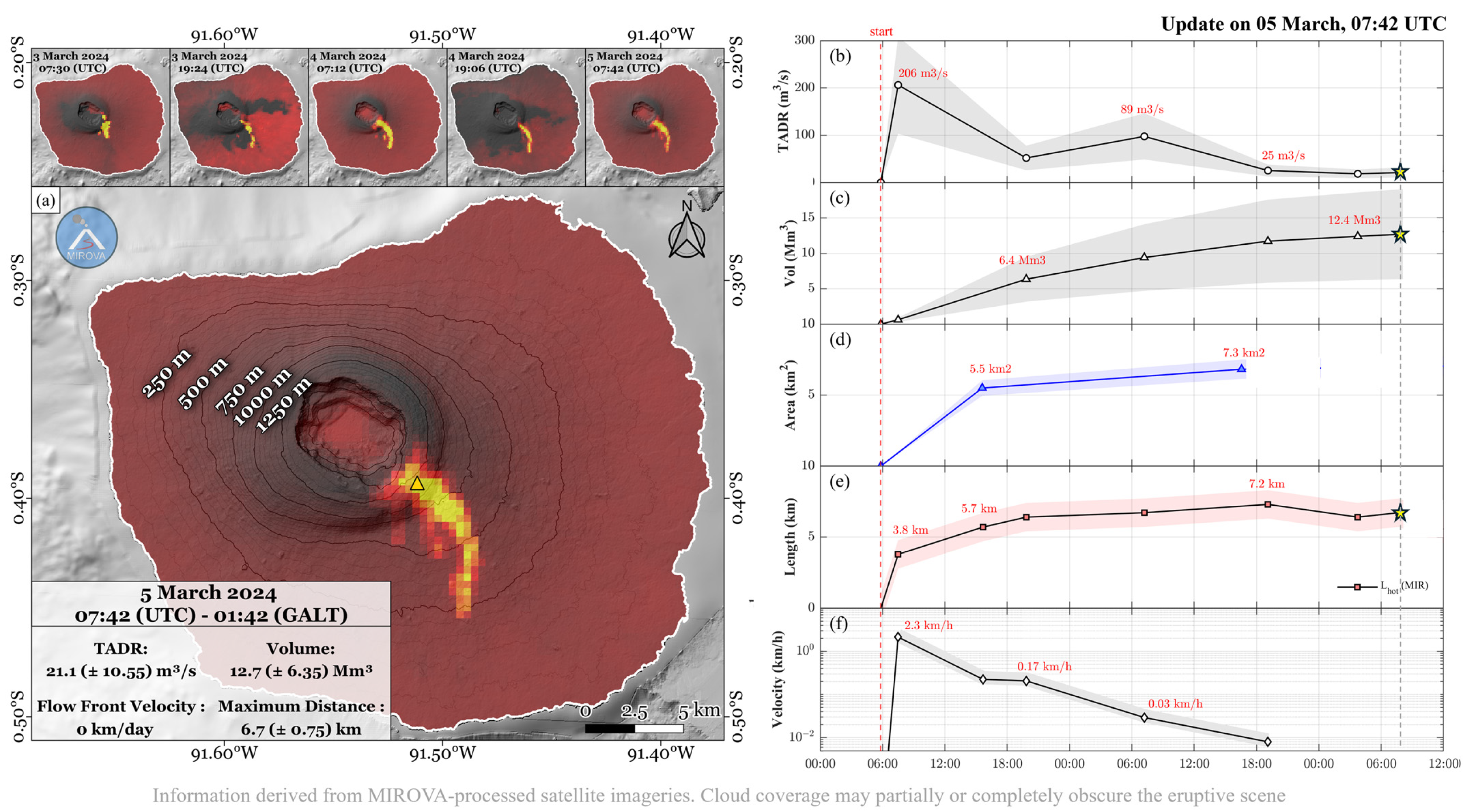
3.1. Rapid Response
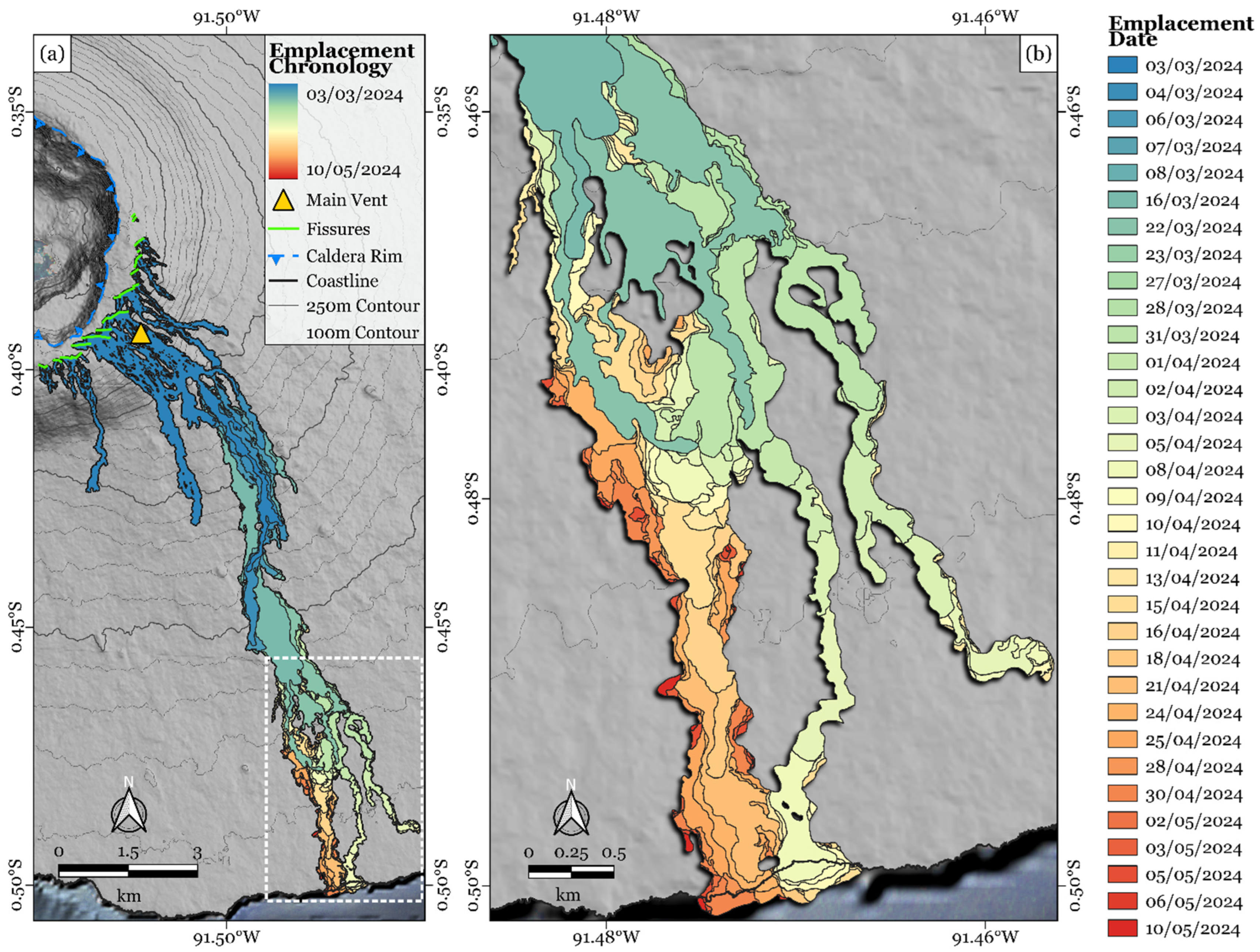
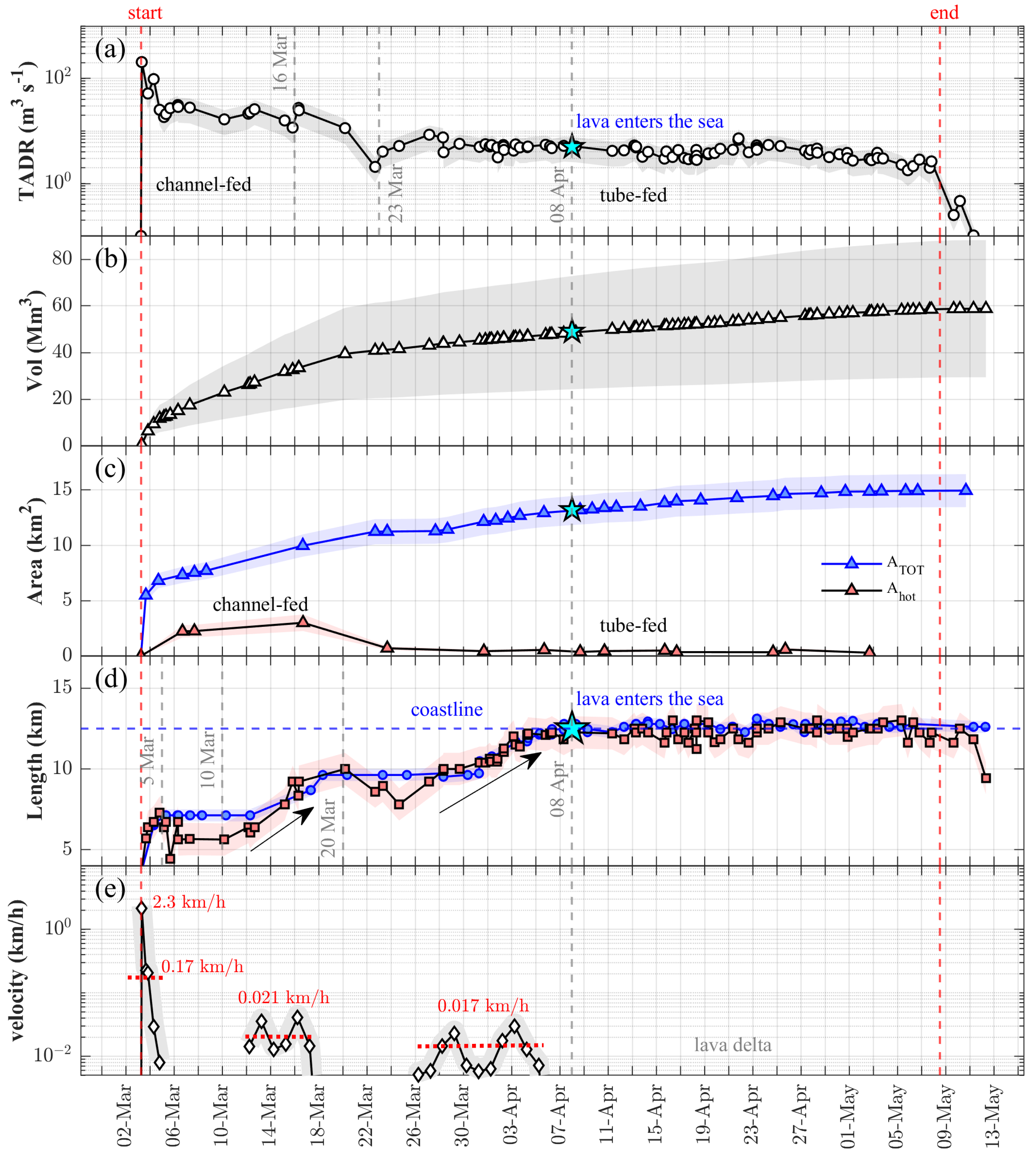
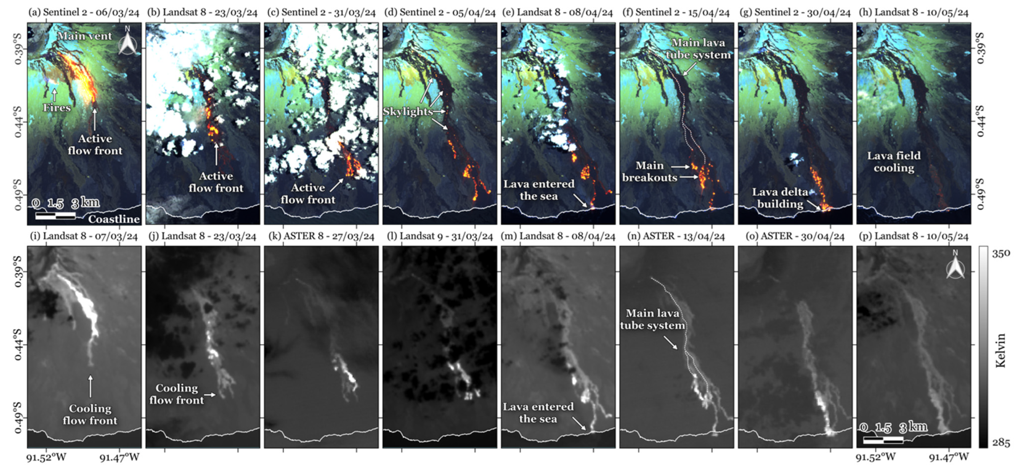
3.2. Lava Flow Evolution for Situational Awareness
4. Discussion
5. Perspective and Conclusive Remarks
- i.
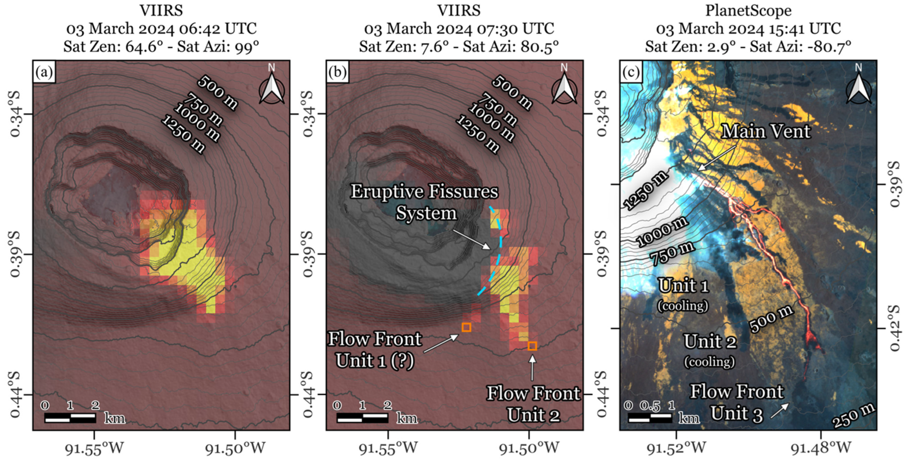
- Team of Experts: the image processing chain, although partially automated, requires continuous expert supervision to manage the workflows—from raw data processing to the generation of maps and time series—as well as to ensure accurate interpretation of the products. Purely automatic systems, while very valuable for immediate initial assessment, can be misleading in the rapid response, as they lack indications of sub-pixel cloud contamination, unfavorable viewing geometry, or false alerts(s) detection. In the example of Figure 5a, without the visual interpretation and evaluation of satellite viewing conditions (which produced extreme geometric distortion of the anomaly), the first thermal alert of 3 March, 06:42 UTC, could have been easily misinterpreted as an intra-caldera eruption. If an eruption starts or shifts into the Fernandina caldera, some explosive activity could occur, due to magma interacting with the crater lake [32]. Consequently, the accurate assessment of thermal anomaly locations and their associated uncertainties is crucial for hazard evaluation. We emphasize that, for a response to be rapid, rigorous, and reliable, expert review and supervision of all images and products remain crucial and indispensable requirements.
- ii.
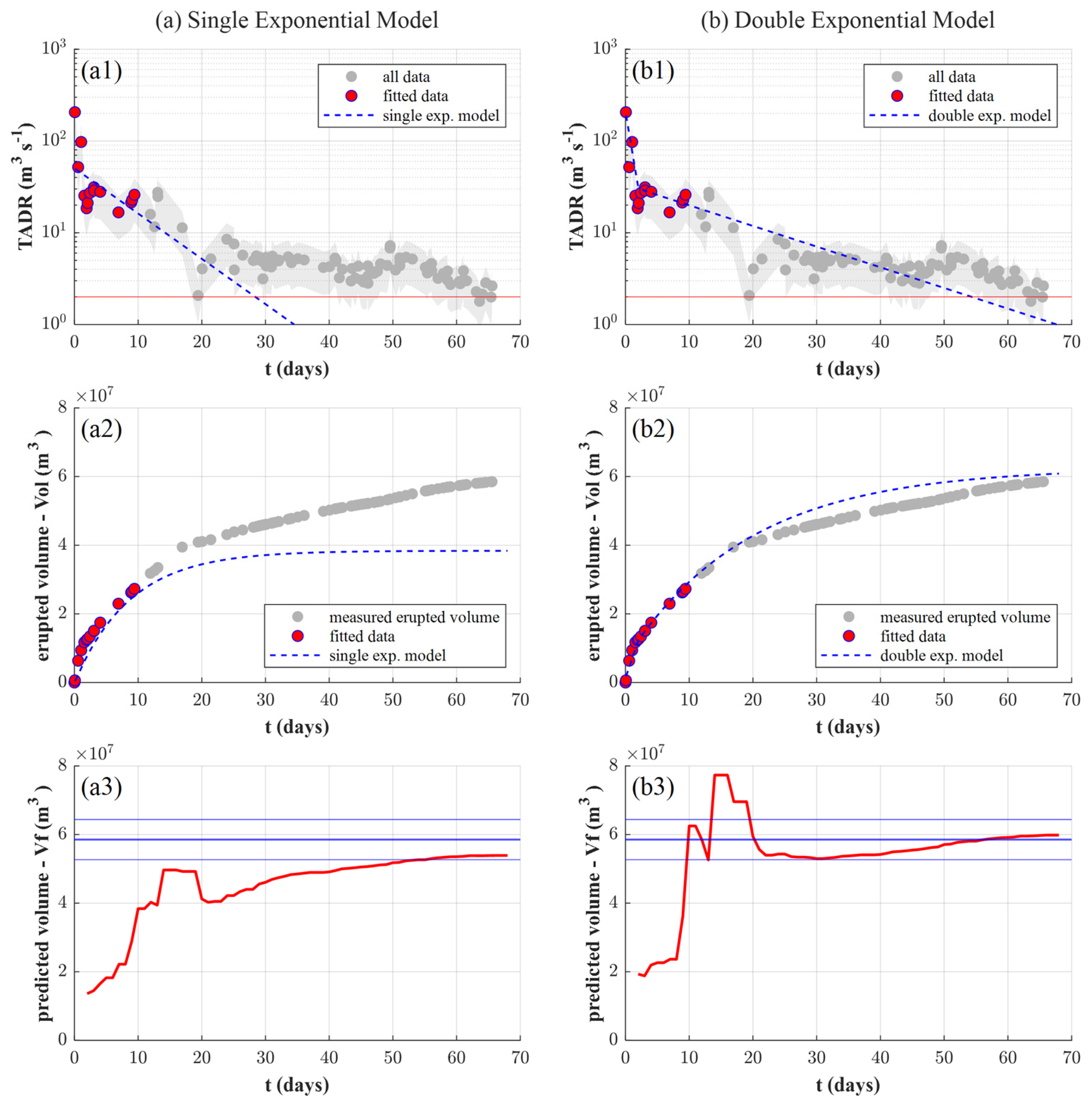
- Calibration: Two of the most important parameters, the TADR and the Vol, are derived from thermal data, using the relationship between effusion rate and instantaneous heat loss over the lava’s “active” area (assuming a time-averaged thermal budget; [92]). This thermal proxy has been declined in many variants (see [25] for a review), and the one used here involves a specific processing chain starting with the MIR radiance data, leading to the VRP, and finally ending with the TADR estimates (Section 2.3.1; Figure 3). It is necessary to underline that the conversion between VRP and TADR requires an ad hoc, volcano-specific calibration, since their relationship is influenced by the rheological and topographical conditions during the emplacement [75,93]. At present, there are several case studies where this approach has been used successfully, but a database of calibration parameters does not yet exist. Finally, we remark that the approach expects that data from multiple MIR sensors are consistent with each other to provide a homogenized time series of VRP following a data fusion technique [58,66,94,95]. At present, polar satellites represent the main source of data used for VRP estimation, especially for global volcano monitoring [26]. For this purpose, we underline that the multiplatform approach proposed here could be further enhanced by adding other polar sensors (i.e., [58]) to enhance the efficiency of satellite thermal data for volcanic surveillance.
Supplementary Materials
Author Contributions
Funding
Data Availability Statement
Acknowledgments
Conflicts of Interest
References
- Harris, A.J.L. Basaltic Lava Flow Hazard. In Volcanic Hazards, Risks, and Disasters; Elsevier: Amsterdam, The Netherlands, 2015; pp. 17–46. [Google Scholar] [CrossRef]
- Kilburn, C.R.J. Lava Flow Hazards and Modeling. In The Encyclopedia of Volcanoes; Academic Press: Cambridge, MA, USA, 2015; pp. 957–969. [Google Scholar] [CrossRef]
- Tsang, S.W.R.; Lindsay, J.M. Lava flow crises in inhabited areas part I: Lessons learned and research gaps related to effusive, basaltic eruptions. J. Appl. Volcanol. 2020, 9, 9. [Google Scholar] [CrossRef]
- Brown, S.K.; Jenkins, S.F.; Sparks, R.S.J.; Odbert, H.; Auker, M.R. Volcanic fatalities database: Analysis of volcanic threat with distance and victim classification. J. Appl. Volcanol. 2017, 6, 15. [Google Scholar] [CrossRef]
- Favalli, M.; Pareschi, M.T.; Neri, A.; Isola, I. Forecasting lava flow paths by a stochastic approach. Geophys. Res. Lett. 2005, 32, L03305. [Google Scholar] [CrossRef]
- Balagizi, C.M.; Kies, A.; Kasereka, M.M.; Tedesco, D.; Yalire, M.M.; McCausland, W.A. Natural hazards in Goma and the surrounding villages, East African Rift System. Nat. Hazards 2018, 93, 31–66. [Google Scholar] [CrossRef]
- Meredith, E.S.; Jenkins, S.F.; Hayes, J.L.; Lallemant, D.; Deligne, N.I.; Teng, N.R.X. Lava flow impacts on the built environment: Insights from a new global dataset. J. Appl. Volcanol. 2024, 13, 1. [Google Scholar] [CrossRef]
- Jenkins, S.F.; Day, S.J.; Faria, B.V.E.; Fonseca, J.F.B.D. Damage from lava flows: Insights from the 2014–2015 eruption of Fogo, Cape Verde. J. Appl. Volcanol. 2017, 6, 6. [Google Scholar] [CrossRef]
- Poland, M.; Orr, T.R.; Kauahikaua, J.P.; Brantley, S.R.; Babb, J.L.; Patrick, M.R.; Neal, C.A.; Anderson, K.R.; Antolik, L.; Burgess, M.; et al. The 2014–2015 Pāhoa lava flow crisis at Kīlauea Volcano, Hawai’i: Disaster avoided and lessons learned. GSA Today 2015, 26, 4–10. [Google Scholar] [CrossRef]
- Meredith, E.S.; Jenkins, S.F.; Hayes, J.L.; Deligne, N.I.; Lallemant, D.; Patrick, M.; Neal, C. Damage assessment for the 2018 lower East Rift Zone lava flows of Kīlauea volcano, Hawai’i. Bull. Volcanol. 2022, 84, 65. [Google Scholar] [CrossRef]
- Biass, S.; Reyes-Hardy, M.-P.; Gregg, C.; Di Maio, L.S.; Dominguez, L.; Frischknecht, C.; Bonadonna, C.; Perez, N. The spatiotemporal evolution of compound impacts from lava flow and tephra fallout on buildings: Lessons from the 2021 Tajogaite eruption (La Palma, Spain). Bull. Volcanol. 2024, 86, 10. [Google Scholar] [CrossRef]
- Gouhier, M.; Pinel, V.; Belart, J.M.C.; De Michele, M.; Proy, C.; Tinel, C.; Berthier, E.; Guéhenneux, Y.; Gudmundsson, M.T.; Óskarsson, B.V.; et al. CNES-ESA satellite contribution to the operational monitoring of volcanic activity: The 2021 Icelandic eruption of Mt. Fagradalsfjall. J. Appl. Volcanol. 2022, 11, 10. [Google Scholar] [CrossRef]
- Pedersen, G.B.M.; Pfeffer, M.A.; Barsotti, S.; Tarquini, S.; d’Michieli Vitturi, M.; Óladóttir, B.A.; Þrastarson, R.H. Lava flow hazard modeling during the 2021 Fagradalsfjall eruption, Iceland: Applications of MrLavaLoba. Nat. Hazards Earth Syst. Sci. 2023, 23, 3147–3168. [Google Scholar]
- Wantim, M.N.; Bonadonna, C.; Gregg, C.E.; Menoni, S.; Frischknecht, C.; Kervyn, M.; Aynghe, S.N. Forensic assessment of the 1999 Mount Cameroon eruption, West-Central Africa. J. Volcanol. Geotherm. Res. 2018, 358, 13–30. [Google Scholar]
- Wilson, G.; Wilson, T.; Deligne, N.I.; Cole, J.W. Volcanic hazard impacts to critical infrastructure: A review. J. Volcanol. Geotherm. Res. 2014, 286, 148–182. [Google Scholar] [CrossRef]
- Harris, A.J.L.; Rhéty, M.; Gurioli, L.; Villeneuve, N.; Paris, R. Simulating the thermorheological evolution of channel-contained lava: FLOWGO and its implementation in EXCEL. Geol. Soc. Lond. Spec. Pub. 2016, 426, 313–336. [Google Scholar] [CrossRef]
- International Charter Annual Report, 2023. Available online: https://disasterscharter.org/cos-api/api/file/public/article-image/25983038 (accessed on 22 March 2025).
- CEMS (Copernicus Emergency Management Service). Web Resource. Available online: https://emergency.copernicus.eu/mapping/sites/default/files/files/CopEMS_FlyerRM-RRM_1.0_2021_0.pdf (accessed on 27 January 2025).
- Vicari, A.; Ganci, G.; Behncke, B.; Cappello, A.; Neri, M.; Del Negro, C. Near-real-time forecasting of lava flow hazards during the 12–13 January 2011 Etna eruption. Geophys. Res. Lett. 2011, 38, L13317. [Google Scholar] [CrossRef]
- Harris, A.J.L.; Chevrel, M.O.; Coppola, D.; Ramsey, M.S.; Hrysiewicz, A.; Thivet, S.; Villeneuve, N.; Favalli, M.; Peltier, A.; Kowalski, P.; et al. Validation of an integrated satellite-data-driven response to an effusive crisis: The April–May 2018 eruption of Piton de la Fournaise. Ann. Geophys. 2019, 61, AC48. [Google Scholar] [CrossRef]
- Laiolo, M.; Ripepe, M.; Cigolini, C.; Coppola, D.; Della Schiava, M.; Genco, R.; Innocenti, L.; Lacanna, G.; Marchetti, E.; Massimetti, F.; et al. Space- and ground-based geophysical data tracking of magma migration in shallow feeding system of Mount Etna Volcano. Remote Sens. 2019, 11, 1182. [Google Scholar] [CrossRef]
- Corradini, S.; Guerrieri, L.; Stelitano, D.; Salerno, G.; Scollo, S.; Merucci, L.; Prestifilippo, M.; Musacchio, M.; Silvestri, M.; Lombardo, V.; et al. Near Real-Time Monitoring of the Christmas 2018 Etna Eruption Using SEVIRI and Products Validation. Remote Sens. 2020, 12, 1336. [Google Scholar] [CrossRef]
- Chevrel, M.O.; Villeneuve, N.; Grandin, R.; Froger, J.-L.; Coppola, D.; Massimetti, F.; Campus, A.; Hrysiewicz, A.; Peltier, A. Lava Flow Daily Monitoring: The Case of the 19 September–5 October 2022 Eruption at Piton De La Fournaise. Volcanica 2023, 6, 391–404. [Google Scholar] [CrossRef]
- Harris, A.J.L.; Villeneuve, N.; Di Muro, A.; Ferrazzini, V.; Peltier, A.; Coppola, D.; Favalli, M.; Bachèlery, P.; Froger, J.-L.; Gurioli, L.; et al. Effusive crises at Piton de la Fournaise 2014–2015: A review of a multi-national response model. J. Appl. Volcanol. 2017, 6, 11. [Google Scholar] [CrossRef]
- Coppola, D.; Barsotti, S.; Cigolini, C.; Laiolo, M.; Pfeffer, M.; Ripepe, M. Monitoring the time-averaged discharge rates, volumes, and emplacement style of large lava flows by using the MIROVA system: The case of the 2014–2015 eruption at Holuhraun (Iceland). Ann. Geophys. 2019, 61, 1–29. [Google Scholar] [CrossRef]
- Coppola, D.; Laiolo, M.; Cigolini, C.; Massimetti, F.; Delle Donne, D.; Ripepe, M.; Arias, H.; Barsotti, S.; Parra, C.B.; Centeno, R.G.; et al. Thermal remote sensing for global volcano monitoring experiences from the Mirova system. Front. Earth Sci. 2020, 7, 362. [Google Scholar] [CrossRef]
- Ganci, G.; Vicari, A.; Cappello, A.; Del Negro, C. An emergent strategy for volcano hazard assessment: From thermal satellite monitoring to lava flow modeling. Remote Sens. Environ. 2012, 119, 197–207. [Google Scholar] [CrossRef]
- Hyman, D.M.R.; Dietterich, H.R.; Patrick, M.R. Toward next-generation lava flow forecasting: Development of a fast, physics-based lava propagation model. J. Geophys. Res. Solid Earth 2022, 127, e2022JB024998. [Google Scholar] [CrossRef]
- Vasconez, F.J.; Anzieta, J.C.; Vásconez Müller, A.; Bernard, B.; Ramón, P. A Near Real-Time and Free Tool for the Preliminary Mapping of Active Lava Flows during Volcanic Crises: The Case of Hotspot Subaerial Eruptions. Remote Sens. 2022, 14, 3483. [Google Scholar] [CrossRef]
- Pritchard, M.E.; Poland, M.; Reath, K.; Andrews, B.; Bagnardi, M.; Biggs, J.; Carn, S.; Coppola, D.; Ebmeier, S.K.; Furtney, M.A.; et al. Optimizing Satellite Resources for the Global Assessment and Mitigation of Volcanic Hazards—Suggestions from the USGS Powell Center Volcano Remote Sensing Working Group; U.S., Geological Survey Scientific Investigations Report 2022–5116: Reston, VA, USA, 2022; 69p. [Google Scholar] [CrossRef]
- Kurz, M.D.; Rowland, S.K.; Curtice, J.; Saal, A.E.; Naumann, T. Eruption Rates for Fernandina Volcano. In The Galápagos: A Natural Laboratory for the Earth Sciences; Geophysical Monograph Series V. 204; Harpp, K.S., Mittelstaedt, E., d’Ozouville, N., Graham, D.W., Eds.; American Geophysical Union: Washington, DC, USA, 2014; pp. 41–54. [Google Scholar] [CrossRef]
- Howard, K.A.; Simkin, T.; Geist, D.J.; Merlen, G.; Nolf, B. Large Hydromagmatic Eruption Related to Fernandina Volcano’s 1968 Caldera Collapse—Deposits, Landforms, and Ecosystem Recovery. In Field Volcanology: A Tribute to the Distinguished Career of Don Swanson; Poland, M.P., Garcia, M.O., Camp, V.E., Grunde, A., Eds.; Geological Society of America: Boulder, CO, USA, 2019. [Google Scholar]
- Kurz, M.D.; Rowland, S.; Curtice, J.; Saal, A.; Naumann, T. Eruption rates at Fernandina volcano, Galápagos archipelago, from cosmogenic helium in surficial lava flows. Eos Trans. AGU 2005, 86, Abstract U33A-0016. [Google Scholar]
- Dvorak, J.J.; Dzurisin, D. Variations in magma supply rate at Kilauea Volcano, Hawaii. J. Geophys. Res. 1993, 98, 22255–22268. [Google Scholar] [CrossRef]
- Geist, D.; Naumann, T.; Larson, P. Evolution of Galapagos magmas: Mantle and crystal fractionation without assimilation. J. Petrol. 1998, 39, 953–971. [Google Scholar] [CrossRef]
- Allan, J.F.; Simkin, T. Fernandina Volcano’s evolved, well-mixed basalts: Mineralogical and petrological constraints on the nature of the Galapagos plume. J. Geophys. Res. 2000, 105, 6017–6041. [Google Scholar] [CrossRef]
- Chadwick, W.; Jónsson, S.; Geist, D.; Poland, M.; Johnson, D.; Batt, S.; Harpp, K.; Ruiz, A. The May 2005 eruption of Fernandina volcano, Galàpagos: The first circumferential dike intrusion observed by GPS and InSAR. Bull. Volcanol. 2011, 73, 679–697. [Google Scholar] [CrossRef]
- Bagnardi, M.; Amelung, F. Space-geodetic evidence for multiple magma reservoirs and subvolcanic lateral intrusions at Fernandina Volcano, Galápagos Islands. J. Geophys. Res. 2012, 117, B10406. [Google Scholar] [CrossRef]
- Bagnardi, M.; Amelung, F.; Poland, M.P. A new model for the growth of basaltic shields based on deformation of Fernandina volcano, Galápagos Islands. Earth Planet. Sci. Lett. 2013, 377, 358–366. [Google Scholar] [CrossRef]
- Pepe, S.; Castaldo, R.; De Novellis, V.; D’Auria, L.; De Luca, C.; Casu, F.; Sansosti, E.; Tizzani, P. New insights on the 2012–2013 uplift episode at Fernandina Volcano (Galápagos). Geophys. J. Int. 2017, 211, 673–685. [Google Scholar] [CrossRef]
- Galetto, F.; Reale, D.; Sansosti, E.; Acocella, V. Implications for shallow magma transfer during the 2017 and 2018 eruptions at Fernandina (Galápagos) inferred from InSAR data. J. Geophys. Res. Solid Earth 2023, 128, e2022JB026174. [Google Scholar] [CrossRef]
- Chestler, S.R.; Grosfils, E.B. Using numerical modeling to explore the origin of intrusion patterns on Fernandina volcano, Galapagos Islands, Ecuador. Geophys. Res. Lett. 2013, 40, 4565–4569. [Google Scholar] [CrossRef]
- Simkin, T.; Howard, K.A. Caldera collapse in the GalàpagosIslands, 1968. Science 1970, 169, 429–437. [Google Scholar] [CrossRef]
- Rowland, S.K. Slopes, lava flow volumes, and vent distributions on Volcán Fernandina, Galápagos Islands. J. Geophys. Res. 1996, 101, 27657–27672. [Google Scholar] [CrossRef]
- Hildreth, W. The timing of caldera collapse at Mount Katmai in response to magma withdrawal toward Norarupta. Geophys. Res. Lett. 1991, 18, 1541–1544. [Google Scholar]
- Vasconez, F.J.; Ramón, P.; Hernandez, S.; Hidalgo, S.; Bernard, B.; Ruiz, M. The different characteristics of the recent eruptions of Fernandina and Sierra Negra volcanoes (Galápagos, Ecuador). Volcanica 2018, 1, 127–133. [Google Scholar] [CrossRef]
- Reddin, E.; Ebmeier, S.; Bagnardi, M.; Bell, A.F.; Espín Bedón, P. Craters of habit: Patterns of deformation in the western Galápagos. Volcanica 2024, 7, 181–227. [Google Scholar] [CrossRef]
- Teasdale, R.; Geist, D.; Kurz, M.; Harpp, K. 1998 eruption at Volcán Cerro Azul, Galápagos Islands: I. Syn-Eruptive Petrogenesis. Bull. Volcanol. 2005, 67, 170–185. [Google Scholar] [CrossRef]
- Chandni, C.K.; Kumar, S.; Babu, A. SBAS-DInSAR analysis of January 2020 eruption of La Cumbre Volcano, Galapagos Archipelago. J. Appl. Geophys. 2022, 206, 104796. [Google Scholar] [CrossRef]
- Pawlowicz, R. M_Map: A Mapping Package for MATLAB. Version 1.4m, [Computer software]. 2020. Available online: www.eoas.ubc.ca/~rich/map.html (accessed on 12 November 2023).
- IG-EPN (2021)–Informe Volcánico Especial–Fernandina–2021–N°01. Available online: https://www.igepn.edu.ec/servicios/busqueda-informes (accessed on 19 February 2025).
- IG-EPN (2022)–IG Al Instante-Fernandina–2022–N°01. Available online: https://www.igepn.edu.ec/servicios/busqueda-informes (accessed on 19 February 2025).
- IG-EPN (2024a)–Informe Volcánico Especial–Fernandina–2024–N° 2024-001. Available online: https://www.igepn.edu.ec/servicios/noticias/2106-informe-volcanico-especial-fernandina-n-2024-001 (accessed on 19 February 2025).
- IG-EPN (2024b)–Informe Volcánico Especial–Fernandina–N° 2024-002. Available online: https://www.igepn.edu.ec/servicios/noticias/2111-informe-volcanico-especial-fernandina-n-2024-002) (accessed on 19 February 2025).
- IG-EPN (2024c)–Informe Volcánico Especial–Fernandina–N° 2024-003. Available online: https://www.igepn.edu.ec/servicios/noticias/2120-informe-volcanico-especial-fernandina-n-2024-003) (accessed on 19 February 2025).
- IG-EPN (2024d)–Informe Volcánico Especial–Fernandina–N° 2024-004. Available online: https://www.igepn.edu.ec/servicios/noticias/2136-informe-volcanico-especial-fernandina-n-2024-004) (accessed on 19 February 2025).
- Blackett, M. Early analysis of Landsat-8 thermal infrared sensor imagery of volcanic activity. Remote Sens. 2014, 6, 2282–2295. [Google Scholar] [CrossRef]
- Aveni, S.; Laiolo, M.; Campus, A.; Massimetti, F.; Coppola, D. The capabilities of FY-3D/MERSI-II sensor to detect and quantify thermal volcanic activity: The 2020–2023 Mount Etna case study. Remote Sens. 2023, 15, 2528. [Google Scholar] [CrossRef]
- Ganci, G.; Cappello, A.; Bilotta, G.; Del Negro, C. How the variety of satellite remote sensing data over volcanoes can assist hazard monitoring efforts: The 2011 eruption of Nabro volcano. Remote Sens. Environ. 2020, 236, 111426. [Google Scholar]
- Ganci, G.; Bilotta, G.; Zuccarello, F.; Calvari, S.; Cappello, A. A multi-sensor satellite approach to characterize the volcanic deposits emitted during Etna’s lava fountaining: The 2020–2022 study case. Remote Sens. 2023, 15, 916. [Google Scholar] [CrossRef]
- Proietti, C.; De Beni, E.; Cantarero, M.; Ricci, T.; Ganci, G. Rapid provision of maps and volcanological parameters: Quantification of the 2021 Etna volcano lava flows through the integration of multiple remote sensing techniques. Bull. Volcanol. 2023, 85, 58. [Google Scholar] [CrossRef]
- Coppola, D.; Laiolo, M.; Cigolini, C.; Delle Donne, D.; Ripepe, M. Enhanced volcanic hot-spot detection using MODIS IR data: Results from the MIROVA system. Geol. Soc. Lond. Spec. Pub. 2016, 426, 181–205. [Google Scholar] [CrossRef]
- Nishihama, M.; Wolfe, R.; Solomon, D.; Patt, F.; Blanchette, J.; Fleig, A.; Masuoka, E. MODIS level 1A Earth Location: Algorithm Theoretical Basis Document, version 3.0. SDST-092; MODIS Science Data Support Team: Sioux Falls, SD, USA, 1997. [Google Scholar]
- Cao, C.; Xiong, X.; Wolfe, R.; DeLuccia, F.; Liu, Q.; Blonski, S.; Lin, G.; Nishihama, M.; Pogorzala, D.; Oudrari, H.; et al. Visible Infrared Imaging Radiometer Suite (VIIRS) Sensor Data Record (SDR) User’s Guide; Version 1.3; NOAA Technical Report NESDIS; NESDIS: College Park, MD, USA, 2017. [Google Scholar]
- Cao, C.; Xiong, J.; Blonski, S.; Liu, Q.; Uprety, S.; Shao, X.; Bai, Y.; Weng, F. Suomi NPP VIIRS sensor data record verification, validation, and long-term performance monitoring. J. Geophys. Res. Atmos 2013, 118, 11664–11678. [Google Scholar] [CrossRef]
- Campus, A.; Laiolo, M.; Massimetti, F.; Coppola, D. The Transition from MODIS to VIIRS for Global Volcano Thermal Monitoring. Sensors 2022, 22, 1713. [Google Scholar] [CrossRef]
- Campus, A.; Aveni, S.; Laiolo, M.; Massimetti, F.; Coppola, D. Thermal unrest at La Fossa (Vulcano Island, Italy): The 2021–2023 VIIRS 375 m MIROVA-processed dataset. Bull. Volcanol. 2024, 86, 25. [Google Scholar] [CrossRef]
- Saunders-Shultz, P.; Lopez, T.; Dietterich, H.; Girona, T. Automatic identification and quantification of volcanic hotspots in Alaska using HotLINK: The hotspot learning and identification network. Front. Earth Sci. 2024, 12, 1345104. [Google Scholar] [CrossRef]
- Blackett, M. An Overview of Infrared Remote Sensing of Volcanic Activity. J. Imaging 2017, 3, 13. [Google Scholar] [CrossRef]
- Massimetti, F.; Coppola, D.; Laiolo, M.; Valade, S.; Cigolini, C.; Ripepe, M. Volcanic hot-spot detection using SENTINEL-2: A comparison with MODIS–MIROVA thermal data series. Remote Sens. 2020, 12, 820. [Google Scholar] [CrossRef]
- Marchese, F.; Genzano, N. Global volcano monitoring through the Normalized Hotspot Indices (NHI) system. J. Geol. Soc. 2023, 180, jgs2022-014. [Google Scholar] [CrossRef]
- Pieri, D.; Abrams, M. ASTER watches the world’s volcanoes: A new paradigm for volcanological observations from orbit. J. Volcanol. Geotherm. Res. 2004, 135, 13–28. [Google Scholar] [CrossRef]
- Ramsey, M.S.; Flynn, I.T.W. The Spatial and Spectral Resolution of ASTER Infrared Image Data: A Paradigm Shift in Volcanological Remote Sensing. Remote Sens. 2020, 12, 738. [Google Scholar] [CrossRef]
- Wooster, M.J.; Zhukov, B.; Oertel, D. Fire radiative energy for quantitative study of biomass burning: Derivation from the BIRD experimental satellite and comparison to MODIS fire products. Remote Sens. Environ. 2003, 86, 83–107. [Google Scholar] [CrossRef]
- Coppola, D.; Laiolo, M.; Piscopo, D.; Cigolini, C. Rheological control on the radiant density of active lava flows and domes. J. Volcanol. Geotherm. Res. 2013, 249, 39–48. [Google Scholar]
- Harris, A.J.L. Thermal Remote Sensing of Active Volcanoes: A User’s Manual; Cambridge University Press: Cambridge, UK, 2013. [Google Scholar]
- Aveni, S.; Laiolo, M.; Campus, A.; Massimetti, F.; Coppola, D. TIRVolcH: Thermal Infrared Recognition of Volcanic Hotspots. A single band TIR-based algorithm to detect low-to-high thermal anomalies in volcanic regions. Remote Sens. Environ. 2024, 315, 114388. [Google Scholar]
- Calle, A.; Casanova, J.L.; González-Alonso, F. Impact of point spread function of MSG SEVIRI on active fire detection. Int. J. Remote Sens. 2009, 30, 4567–4579. [Google Scholar] [CrossRef]
- Zakšek, K.; Hort, M.; Lorenz, E. Satellite and Ground Based Thermal Observation of the 2014 Effusive Eruption at Stromboli Volcano. Remote Sens. 2015, 7, 17190–17211. [Google Scholar] [CrossRef]
- Head, E.M.; Maclean, A.L.; Carn, S.A. Mapping lava flows from Nyamuragira volcano (1967–2011) with satellite data and automated classification methods. Geomat. Nat. Hazards Risk 2022, 4, 119–144. [Google Scholar] [CrossRef]
- IG-EPN (2024e)-IG Al Instante 2024-N°01. Available online: https://www.igepn.edu.ec/servicios/busqueda-informes (accessed on 19 February 2025).
- Harris, A.J.L.; Rowland, S.K. Effusion Rate Controls on Lava Flow Length and the Role of Heat Loss: A Review. In Studies in Volcanology: The Legacy of George Walker; Thordarson, T., Self, S., Larsen, G., Rowland, S.K., Hoskuldsson, A., Eds.; Geological Society of London: London, UK, Special Publication; 2009; IAVCEI, 2; pp. 33–51. [Google Scholar]
- Walker, G.P.L. Lengths of lava flows. Phil. Trans. R. Soc. London. Ser. A Math. Phys. Sci. 1973, 274, 107–118. [Google Scholar] [CrossRef]
- Cordonnier, B.; Lev, E.; Garel, F. Benchmarking lava-flow models. Geol. Soc. Lond. Spec. Pub. 2016, 426, SP426.7. [Google Scholar] [CrossRef]
- Dietterich, H.R.; Lev, E.; Chen, J.; Richardson, J.A.; Cashman, K.V. Benchmarking computational fluid dynamics models of lava flow simulation for hazard assessment, forecasting, and risk management. J. Appl. Volcanol. 2017, 6, 1–14. [Google Scholar] [CrossRef]
- Chevrel, M.O.; Harris, A.; Peltier, A.; Villeneuve, N.; Coppola, D.; Gouhier, M.; Drenne, S. Volcanic crisis management supported by near real-time lava flow hazard assessment at Piton de la Fournaise, La Réunion. Volcanica 2022, 5, 313–334. [Google Scholar] [CrossRef]
- Bonny, E.; Wright, R. Predicting the end of lava flow-forming eruptions from space. Bull. Volcanol. 2017, 79, 52. [Google Scholar] [CrossRef]
- Wadge, G. The variation of magma discharge during basaltic eruptions. J. Volcanol. Geotherm. Res. 1981, 11, 139–168. [Google Scholar]
- Aki, K.; Ferrazzini, V. Comparison of Mount Etna, Kilauea, and Piton de la Fournaise by a quantitative modeling of their eruption histories. J. Geophys. Res. 2001, 106, 4091–4102. [Google Scholar] [CrossRef]
- Blake, S.; Cortés, J.A. Forecasting deflation, intrusion and eruption at inflating volcanoes. Earth Planet. Sci. Lett 2018, 481, 246–254. [Google Scholar] [CrossRef]
- Coppola, D.; Ripepe, M.; Laiolo, M.; Cigolini, C. Modelling Satellite-derived magma discharge to explain caldera collapse. Geology 2017, 45, 523–526. [Google Scholar] [CrossRef]
- Harris, A.J.L.; Baloga, S.M. Lava discharge rates from satellite-measured heat flux. Geophys. Res. Lett. 2009, 36, L19302. [Google Scholar] [CrossRef]
- Bernard, B.; Gibson, S.; Ramon, P.; Gleeson, M.; Stock, M.; Hernandez, S.; Coppola, D.; Bagnardi, M.; Hidalgo, S. Chronology and phenomenology of the 1982 and 2015 Wolf volcano eruptions, Galápagos Archipelago. J. Volcanol. Geotherm. Res. 2019, 374, 26–38. [Google Scholar] [CrossRef]
- Di Bella, G.S.; Corradino, C.; Cariello, S.; Torrisi, F.; Del Negro, C. Advancing Volcanic Activity Monitoring: A Near-Real-Time Approach with Remote Sensing Data Fusion for Radiative Power Estimation. Remote Sens. 2024, 16, 2879. [Google Scholar] [CrossRef]
- Massimetti, F.; Laiolo, M.; Aiuppa, A.; Aveni, S.; Bitetto, M.; Campus, A.; Coltelli, M.; Cristaldi, A.; Donne, D.D.; Innocenti, L.; et al. Thermal emissions of active craters at Stromboli Volcano: Spatio-temporal insights from 10 years of satellite observations. J. Geophys. Res. Solid Earth 2024, 129, e2024JB029143. [Google Scholar] [CrossRef]


| Product Latency (hours) | 1–4 | 6–12 | > 12 | |||||||||||
|---|---|---|---|---|---|---|---|---|---|---|---|---|---|---|
| Sensor | MODIS | VIIRS (M-bands) | VIIRS (I-bands) | MSI | OLI | TIRS | ASTER | Planet Scope | ||||||
| Satellite | TERRA | AQUA | S-NPP | NOAA-20 | S-NPP | NOAA-20 | Sentinel 2A | Sentinel 2B | Landsat 8 | Landsat 9 | Landsat 8 | Landsat 9 | TERRA | PlanetScope |
| Equator Crossing Time | 10:30 LT | 13:30 LT | 13:30 LT | 12:40 LT | 13:30 LT | 12:40 LT | 10:30 LT | 10:00 LT | 22:00 LT | 10:00 LT | 22:00 LT | 10:30 LT | 7:30–11:30 | |
| Global Coverage | Every 12 h | Every 12 h | Every 12 h | 10 days | 16 days | 16 days | 16 days | ~24 h | ||||||
| (5 in const) | (8 in const) | (8 in const) | ||||||||||||
| Spectral region | MIR, TIR | MIR, TIR | MIR, TIR | NIR, SWIR | NIR, SWIR | TIR | TIR | VNIR | ||||||
| Pixel res. at nadir | 1 km | 0.75 km | 0.375 km | 20 m | 30 m | 100 m | 90 m | 4 m | ||||||
| Spectral range (µm) | 3.929–3.989 3.940–4.001 10.78–11.28 | 3.973–4.128 10.26–11.26 | 3.550–3.930 10.56–12.43 | 0.855–0.875 1.565–1.655 2.100–2.280 | 0.851–0.879 1.566–1.651 2.107–2.294 | 10.60–11.19 11.50–12.51 | 10.95–11.65 | 0.650–0.680 0.697–0.713 0.845–0.885 | ||||||
| ID Band(s) | 21 22 31 | M-13 M-15 | I-4 I-5 | 8a 11 12 | 5 6 7 | 10 11 | 14 | Red RedEdge NIR | ||||||
| MIROVA NRT Workflow | HRES Workflow | |||||||||||||
Disclaimer/Publisher’s Note: The statements, opinions and data contained in all publications are solely those of the individual author(s) and contributor(s) and not of MDPI and/or the editor(s). MDPI and/or the editor(s) disclaim responsibility for any injury to people or property resulting from any ideas, methods, instructions or products referred to in the content. |
© 2025 by the authors. Licensee MDPI, Basel, Switzerland. This article is an open access article distributed under the terms and conditions of the Creative Commons Attribution (CC BY) license (https://creativecommons.org/licenses/by/4.0/).
Share and Cite
Coppola, D.; Aveni, S.; Campus, A.; Laiolo, M.; Massimetti, F.; Bernard, B. Rapid Response to Effusive Eruptions Using Satellite Infrared Data: The March 2024 Eruption of Fernandina (Galápagos). Remote Sens. 2025, 17, 1191. https://doi.org/10.3390/rs17071191
Coppola D, Aveni S, Campus A, Laiolo M, Massimetti F, Bernard B. Rapid Response to Effusive Eruptions Using Satellite Infrared Data: The March 2024 Eruption of Fernandina (Galápagos). Remote Sensing. 2025; 17(7):1191. https://doi.org/10.3390/rs17071191
Chicago/Turabian StyleCoppola, Diego, Simone Aveni, Adele Campus, Marco Laiolo, Francesco Massimetti, and Benjamin Bernard. 2025. "Rapid Response to Effusive Eruptions Using Satellite Infrared Data: The March 2024 Eruption of Fernandina (Galápagos)" Remote Sensing 17, no. 7: 1191. https://doi.org/10.3390/rs17071191
APA StyleCoppola, D., Aveni, S., Campus, A., Laiolo, M., Massimetti, F., & Bernard, B. (2025). Rapid Response to Effusive Eruptions Using Satellite Infrared Data: The March 2024 Eruption of Fernandina (Galápagos). Remote Sensing, 17(7), 1191. https://doi.org/10.3390/rs17071191