An Integrated Approach Using Remote Sensing and Multi-Criteria Decision Analysis to Mitigate Agricultural Drought Impact in the Mazowieckie Voivodeship, Poland
Abstract
1. Introduction
2. Materials and Methods
2.1. Study Area
2.2. Geospatial Data Collection
2.3. Analysis for Drought Risk Assessment
2.3.1. HRL Land Cover Categories
2.3.2. Identification of Drought Frequency in Gminy Mazowieckie
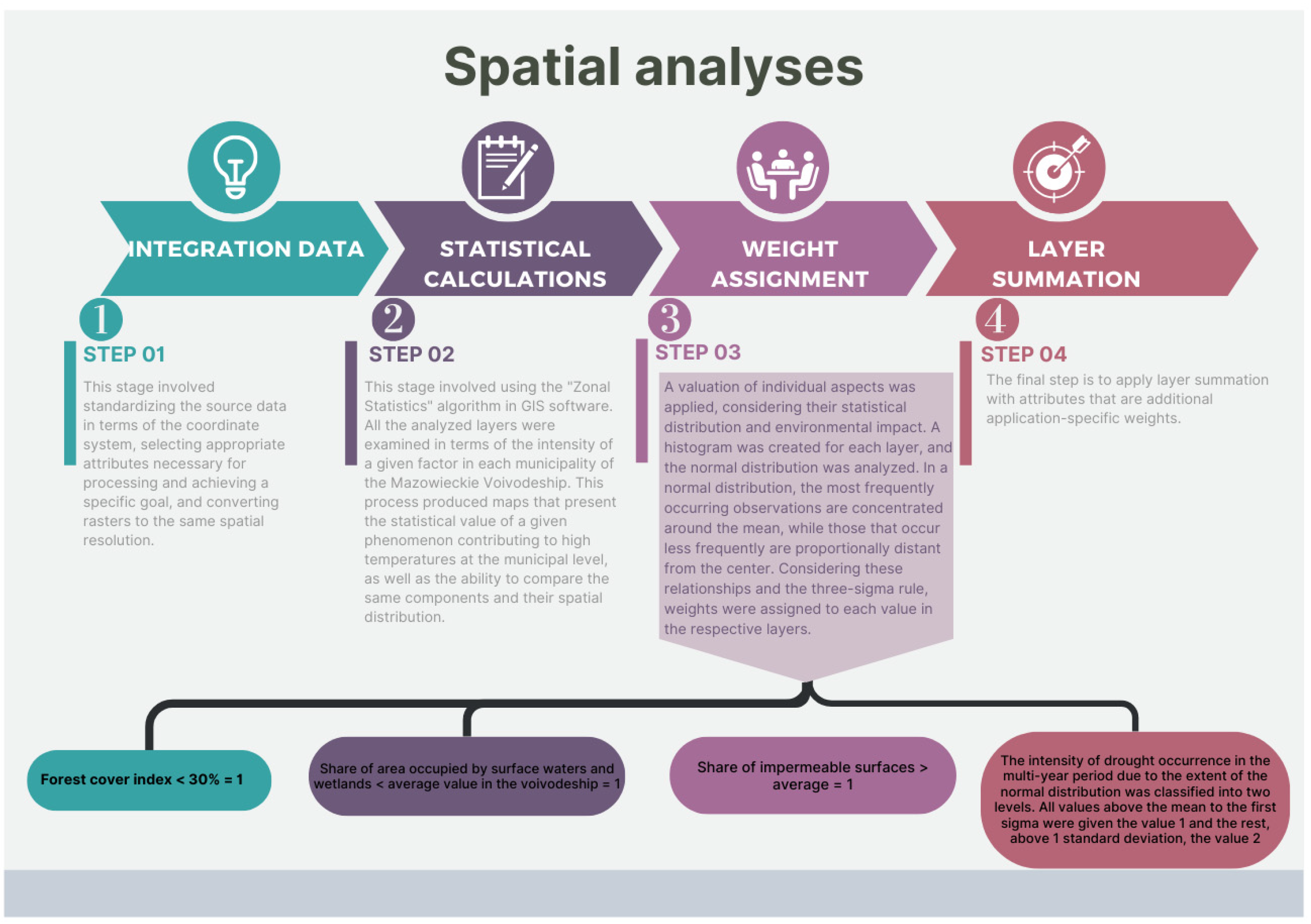
2.3.3. Multi-Criteria Decision Analysis
- Forest cover index < 30% = 1;
- Proportion of surface water and wetland areas < the average value in the voivodeship = 1;
- Proportion of impervious surfaces > the average = 1.
3. Results
3.1. Spatial Distribution of HRL Land-Cover Types
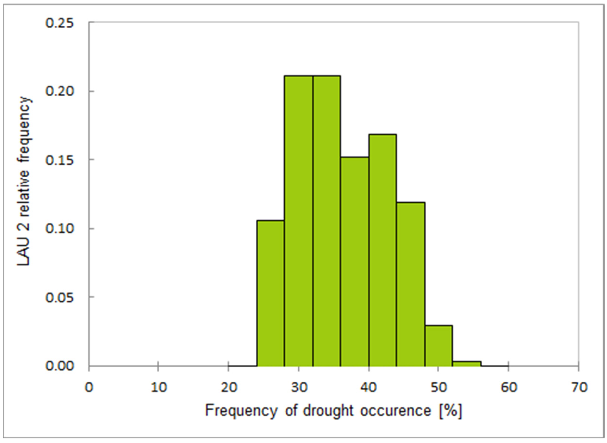
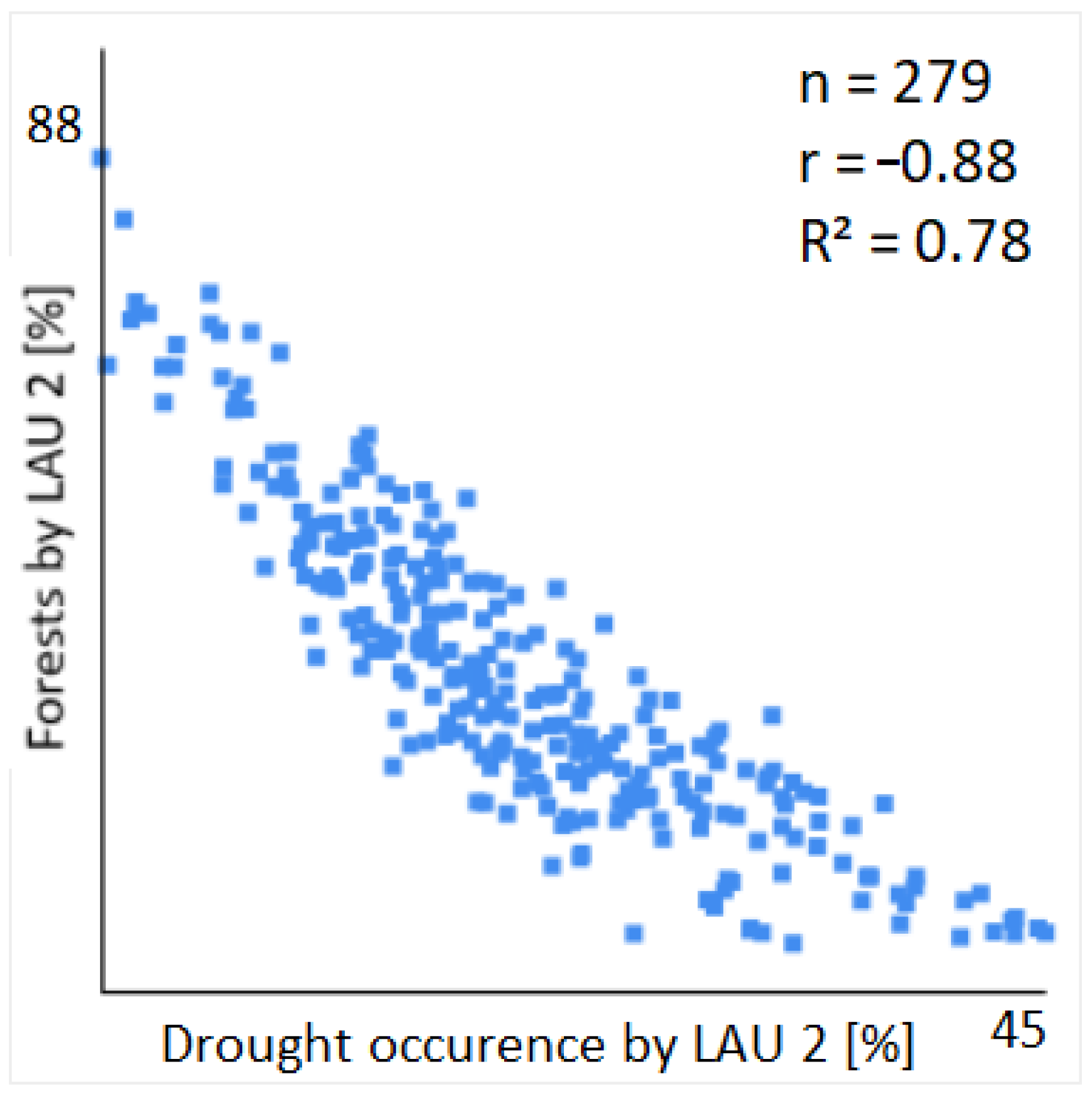
3.2. Drought Occurrence Frequency
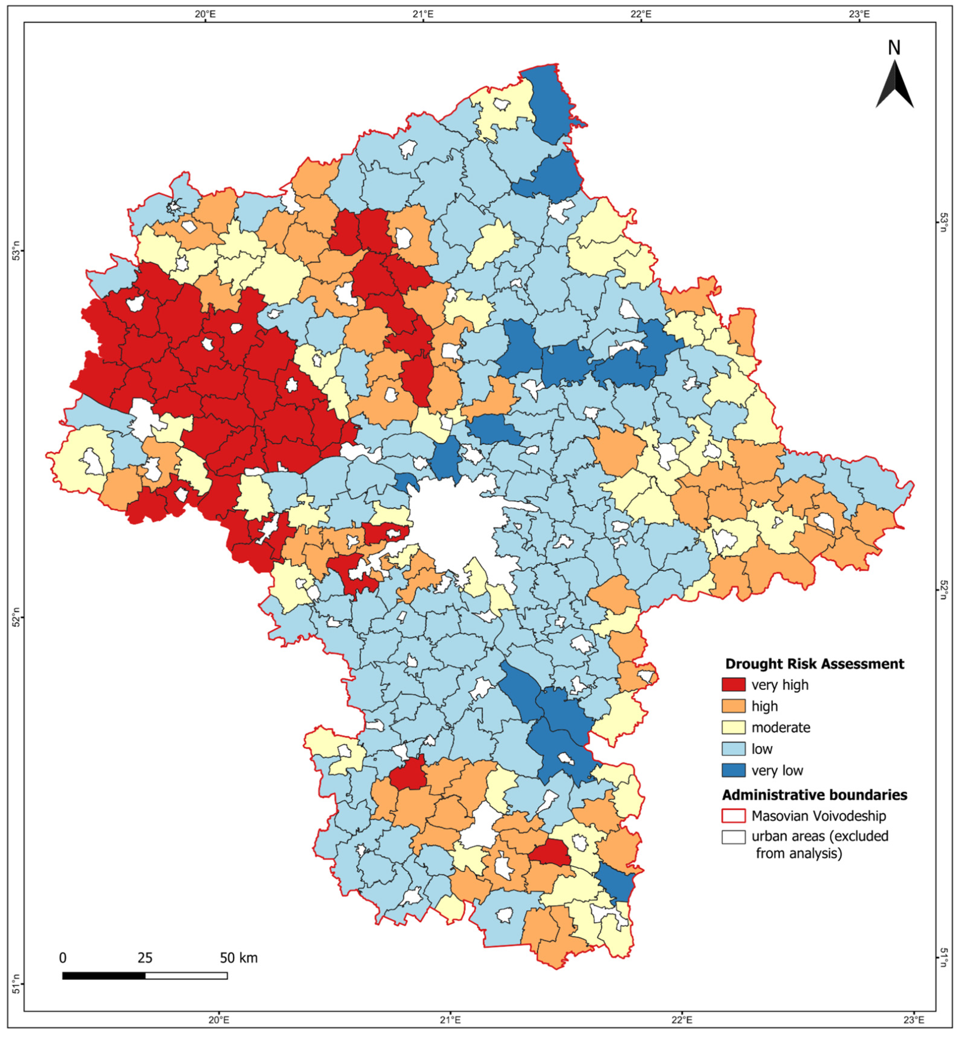
3.3. Assessment of Drought Risk
4. Discussion
5. Conclusions
Author Contributions
Funding
Data Availability Statement
Conflicts of Interest
References
- Intergovernmental Panel On Climate Change (IPCC). Climate Change 2022—Impacts, Adaptation and Vulnerability: Working Group II Contribution to the Sixth Assessment Report of the Intergovernmental Panel on Climate Change, 1st ed.; Cambridge University Press: Cambridge, UK, 2023; ISBN 978-1-00-932584-4. [Google Scholar]
- Wiebe, K.; Lotze-Campen, H.; Sands, R.; Tabeau, A.; Van Der Mensbrugghe, D.; Biewald, A.; Bodirsky, B.; Islam, S.; Kavallari, A.; Mason-D’Croz, D.; et al. Climate Change Impacts on Agriculture in 2050 under a Range of Plausible Socioeconomic and Emissions Scenarios. Environ. Res. Lett. 2015, 10, 085010. [Google Scholar] [CrossRef]
- Lesk, C.; Rowhani, P.; Ramankutty, N. Influence of Extreme Weather Disasters on Global Crop Production. Nature 2016, 529, 84–87. [Google Scholar] [CrossRef] [PubMed]
- Bartoszek, K.; Matuszko, D.; Węglarczyk, S. Trends in Sunshine Duration in Poland (1971–2018). Int. J. Climatol. 2021, 41, 73–91. [Google Scholar] [CrossRef]
- NIK Report No. 192/2020/P/20/043/KRR, 2020 Entitled “Przeciwdziałanie Niedoborom Wody w Rolnictwie”. Available online: https://www.nik.gov.pl/plik/id,23582,vp,26318.pdf (accessed on 18 May 2022). (In Polish)
- Kalbarczyk, R.; Kalbarczyk, E. Research into Meteorological Drought in Poland during the Growing Season from 1951 to 2020 Using the Standardized Precipitation Index. Agronomy 2022, 12, 2035. [Google Scholar] [CrossRef]
- Arun Kumar, K.C.; Reddy, G.P.O.; Masilamani, P.; Turkar, S.Y.; Sandeep, P. Integrated Drought Monitoring Index: A Tool to Monitor Agricultural Drought by Using Time-Series Datasets of Space-Based Earth Observation Satellites. Adv. Space Res. 2021, 67, 298–315. [Google Scholar] [CrossRef]
- Mashala, M.J.; Dube, T.; Mudereri, B.T.; Ayisi, K.K.; Ramudzuli, M.R. A Systematic Review on Advancements in Remote Sensing for Assessing and Monitoring Land Use and Land Cover Changes Impacts on Surface Water Resources in Semi-Arid Tropical Environments. Remote Sens. 2023, 15, 3926. [Google Scholar] [CrossRef]
- Patel, R.; Patel, A. Evaluating the impact of climate change on drought risk in semi-arid region using GIS technique. Results Eng. 2024, 21, 101957. [Google Scholar] [CrossRef]
- Wang, J.; Wang, Y.; Li, G.; Qi, Z. Integration of Remote Sensing and Machine Learning for Precision Agriculture: A Comprehensive Perspective on Applications. Agronomy 2024, 14, 1975. [Google Scholar] [CrossRef]
- Pizzorni, M.; Innocenti, A.; Tollin, N. Droughts and floods in a changing climate and implications for multi-hazard urban planning: A review. City Environ. Interact. 2024, 24, 100169. [Google Scholar] [CrossRef]
- Ward, P.J.; de Ruiter, M.C.; Mård, J.; Schröter, K.; Van Loon, A.; Veldkamp, T.; von Uexkull, N.; Wanders, N.; AghaKouchak, A.; Arnbjerg-Nielsen, K.; et al. The need to integrate flood and drought disaster risk reduction strategies. Water Secur. 2020, 11, 100070. [Google Scholar] [CrossRef]
- Woś, A. Klimat Polski; Wydawnictwo Naukowe PWN: Warsaw, Poland, 1999. (In Polish) [Google Scholar]
- Wójcik, M.; Traczyk, A. Changes in the Spatial Organisation of Fruit Growing at the Beginning of the 21St Century: The Case of Grójec Poviat (Mazovia Voivodeship, Poland). Quaest. Geogr. 2017, 36, 71–84. [Google Scholar] [CrossRef][Green Version]
- Kondracki, J. Regiony Fizycznogeograficzne Polski; Wydawnictwa Uniwersytetu Warszawskiego: Warszawa, Poland, 1977. (In Polish) [Google Scholar]
- Borzęcka, I.; Buras, P.; Szlakowski, J.; Gasiński, Z.; Wiśniewolski, W. The fish fauna in selected rivers of Mazovian Lowland. Fragm. Faun. 2012, 55, 75–90. [Google Scholar] [CrossRef]
- Ostaszewska, K.; Richling, A. Geografia Fizyczna Polski; Wydawnictwo Naukowe PWN: Warsaw, Poland, 2005; ISBN 83-01-14426-2. (In Polish) [Google Scholar]
- Śleszyński, P. Klasyfikacja gmin województwa mazowieckiego= Classification of gminas in Poland’s Mazowieckie voivodship. Przegląd Geogr. 2012, 84, 559–576. (In Polish) [Google Scholar] [CrossRef]
- Forest Type 2018 (Raster 10 m), Europe, 3-Yearly. Available online: https://doi.org/10.2909/59b0620c-7bb4-4c82-b3ce-f16715573137 (accessed on 28 October 2022).
- Small Woody Features 2018 (Raster 5 m), Europe, 3-Yearly. Available online: https://doi.org/10.2909/a8e683b1-2f96-45c8-827f-580a79413018 (accessed on 28 October 2022).
- Tree Cover Density 2018 (Raster 10 m), Europe, 3-Yearly. Available online: https://doi.org/10.2909/486f77da-d605-423e-93a9-680760ab6791 (accessed on 28 October 2022).
- Water and Wetness 2018 (Raster 10 m), Europe, 3-Yearly. Available online: https://doi.org/10.2909/7992f641-bf77-47b7-b0c1-74fc832b78b1 (accessed on 28 October 2022).
- Imperviousness Density 2018 (Raster 10 m), Europe, 3-Yearly. Available online: https://doi.org/10.2909/3bf542bd-eebd-4d73-b53c-a0243f2ed862 (accessed on 28 October 2022).
- Dabrowska-Zielinska, K.; Malinska, A.; Bochenek, Z.; Bartold, M.; Gurdak, R.; Paradowski, K.; Lagiewska, M. Drought Model DISS Based on the Fusion of Satellite and Meteorological Data under Variable Climatic Conditions. Remote Sens. 2020, 12, 2944. [Google Scholar] [CrossRef]
- Local Administrative Units (LAU). Available online: https://ec.europa.eu/eurostat/web/nuts/local-administrative-units (accessed on 28 October 2022).
- Turlej, K.; Bojanowski, J.; Bartold, M. Maska obszarów rolniczych dostosowana do monitoringu wzrostu roślin uprawnych w Polsce przy użyciu szeregów czasowych NOAA-AVHRR. Arch. Fotogram. Kartogr. I Teledetekcji 2013, 25, 233–242. (In Polish) [Google Scholar]
- Dabrowska-Zielinska, K.; Bochenek, Z.; Malinska, A.; Bartold, M.; Gurdak, R.; Lagiewska, M.; Paradowski, K. Drought Assessment Applying Joined Meteorological and Satellite Data. In Proceedings of the 2021 IEEE International Geoscience and Remote Sensing Symposium IGARSS, Brussels, Belgium, 11–16 July 2021; pp. 6591–6594. [Google Scholar] [CrossRef]
- Penny, J.; Khadka, D.; Alves, P.B.; Chen, A.S.; Djordjević, S. Using multi criteria decision analysis in a geographical information system framework to assess drought risk. Water Res. X 2023, 20, 100190. [Google Scholar] [CrossRef]
- Dolui, G.; Das, N.; Guchhait, S.; Roy, S. Multi-Criteria Decision-Making Approach Using Remote Sensing and GIS for Assessment of Groundwater Resources; Springer: Berlin/Heidelberg, Germany, 2021; pp. 59–79. [Google Scholar] [CrossRef]
- Khan, K.A.; Hashmi, M.A. Drought Mitigation and Preparedness Planning using RS and GIS. In Proceedings of the 2006 International Conference on Advances in Space Technologies, Islamabad, Pakistan, 2–3 September 2006; pp. 136–141. [Google Scholar] [CrossRef]
- Belal, A.-A.; El-Ramady, H.R.; Mohamed, E.S.; Saleh, A.M. Drought risk assessment using remote sensing and GIS techniques. Arab. J. Geosci. 2014, 7, 35–53. [Google Scholar] [CrossRef]
- Galiński, M.; Siwek, G.; Szuwarski, J. Metoda Bonitacji Punktowej Jako Narzędzie Waloryzacji Zjawisk Przestrzennych. Geomatyka I Inżynieria 2013, 2, 5–20. [Google Scholar]
- Bartkowski, T. O Metodyce Oceny Środowiska Geograficznego. Przegląd Geogr. 1971, 53, 263–281. (In Polish) [Google Scholar]
- Sołowiej, D. Podstawy Metodyki Oceny Środowiska Przyrodniczego Człowieka; Wydawnictwo Naukowe Uniwersytetu im. Adama Mickiewicza: Poznań, Poland, 1992. (In Polish) [Google Scholar]
- Litwin, U.; Bacior, S.; Piech, I. Metodyka waloryzacji i oceny krajobrazu. Geod. Kartogr. I Fotogram. 2009, 71, 14–25. (In Polish) [Google Scholar]
- Abuzar, M.K.; Mahmood, S.A.; Sarwar, F.; Saleem, A.R.; Khubaib, N.; Malik, A.H.; Shaista, S. Drought risk assessment using GIS and remote sensing: A case study of District Khushab, Pakistan. In Proceedings of the 15th International Conference on Environmental Science and Technology, Rhodes, Greece, 31 August–2 September 2017. [Google Scholar]
- Ihinegbu, C.; Ogunwumi, T. Multi-criteria modelling of drought: A study of Brandenburg Federal State, Germany. Model. Earth Syst. Environ. 2022, 8, 2035–2049. [Google Scholar] [CrossRef]
- Dembek, W.; Oświt, J. Niektóre aspekty roli mokradeł w gospodarce wodnej krajobrazu. Some aspects of the role of wetlands in the water management). Wiadomości Melior. I Łąkarskie 1989, 8, 150–161. (In Polish) [Google Scholar]
- Dabrowska-Zielinska, K.; Budzynska, M.; Tomaszewska, M.; Bartold, M.; Gatkowska, M. The study of multifrequency microwave satellite images for vegetation biomass and humidity of the area under Ramsar convention. In Proceedings of the 2015 IEEE International Geoscience and Remote Sensing Symposium (IGARSS), Milan, Italy, 26–31 July 2015; pp. 5198–5200. [Google Scholar] [CrossRef]
- Dąbrowska-Zielińska, K.; Budzyńska, M.; Kowalik, W.; Małek, I.; Gatkowska, M.; Bartold, M.; Turlej, K. Biophysical Parameters Assessed from Microwave and Optical Data. Int. J. Electron. Telecommun. 2012, 58, 99–104. [Google Scholar] [CrossRef]
- Dąbrowska-Zielińska, K.; Ciołkosz, A.; Malińska, A.; Bartold, M. Monitoring of agricultural drought in Poland using data derived from environmental satellite images. Geoinf. Issues 2011, 3, 87–97. [Google Scholar] [CrossRef]
- Bojanowski, J.S.; Sikora, S.; Musiał, J.P.; Woźniak, E.; Dąbrowska-Zielińska, K.; Slesiński, P.; Milewski, T.; Łączyński, A. Integration of Sentinel-3 and MODIS Vegetation Indices with ERA-5 Agro-Meteorological Indicators for Operational Crop Yield Forecasting. Remote Sens. 2022, 14, 1238. [Google Scholar] [CrossRef]
- Bartold, M.; Wróblewski, K.; Kluczek, M.; Dąbrowska-Zielińska, K.; Goliński, P. Examining the Sensitivity of Satellite-Derived Vegetation Indices to Plant Drought Stress in Grasslands in Poland. Plants 2024, 13, 2319. [Google Scholar] [CrossRef]
- Wang, T.; Sun, F. Integrated drought vulnerability and risk assessment for future scenarios: An indicator based analysis. Sci. Total Environ. 2023, 900, 165591. [Google Scholar] [CrossRef]
- Fava, F.; Vrieling, A. Earth Observation for Drought Risk Financing in Pastoral Systems of Sub-Saharan Africa. Curr. Opin. Environ. Sustain. 2021, 48, 44–52. [Google Scholar] [CrossRef]
- Ha, T.V.; Huth, J.; Bachofer, F.; Kuenzer, C. A Review of Earth Observation-Based Drought Studies in Southeast Asia. Remote Sens. 2022, 14, 3763. [Google Scholar] [CrossRef]
- Crocetti, L.; Forkel, M.; Fischer, M.; Jurečka, F.; Grlj, A.; Salentinig, A.; Trnka, M.; Anderson, M.; Ng, W.-T.; Kokalj, Ž.; et al. Earth observation for agricultural drought monitoring in the Pannonian Basin (Southeastern Europe): Current state and future directions. Reg. Environ. Chang. 2020, 20, 123. [Google Scholar] [CrossRef]
- Singh, G.; Das, N.N.; Prasad, P.V. Geospatial monitoring and analysis of agricultural drought to identify hotspots and risk assessment for Senegal. Geogr. Sustain. 2024, 6, 100248. [Google Scholar] [CrossRef]
- Vicente-Serrano, S.M.; Beguería, S.; Gimeno, L.; Eklundh, L.; Giuliani, G.; Weston, D.; El Kenawy, A.; López-Moreno, J.I.; Nieto, R.; Ayenew, T.; et al. Challenges for drought mitigation in Africa: The potential use of geospatial data and drought information systems. Appl. Geogr. 2012, 34, 471–486. [Google Scholar] [CrossRef]
- IPCC. 2023: Sections. In Climate Change 2023: Synthesis Report. Contribution of Working Groups I, II and III to the Sixth Assessment Report of the Intergovernmental Panel on Climate Change; Core Writing Team, Lee, H., Romero, J., Eds.; IPCC: Geneva, Switzerland; pp. 35–115. [CrossRef]
- Ministry of Climate and Environment; Department of Forestry and Hunting. Information on the State of Forests and the Implementation of the National Forest Afforestation Program in 2019 Warsaw. Available online: https://www.gov.pl/attachment/1c4d8d8e-c93a-40ce-8c05-5cd691fe3182 (accessed on 20 November 2024).
- Council of Ministers of Poland; Ministry of Environment. Program for Counteracting Water Shortage for the Years 2023–2027 with a Perspective to 2030 (Resolution No. 152 of August 22, 2023). Monitor Polski, Item 1119. Available online: https://isap.sejm.gov.pl/isap.nsf/download.xsp/WMP20230001119/O/M20231119.pdf (accessed on 3 December 2024).
- Minister of Infrastructure. Regulation Regarding the Adoption of the Drought Consequences Mitigation Plan (Dz.U. 2021 poz. 1615) Dziennik Ustaw, 3 September 2021. Available online: https://dziennikustaw.gov.pl/DU/2021/1615 (accessed on 25 November 2024). (In Polish)
- Gao, F.; Zhang, S.; Yu, R.; Zhao, Y.; Chen, Y.; Zhang, Y. Agricultural Drought Risk Assessment Based on a Comprehensive Model Using Geospatial Techniques in Songnen Plain, China. Land 2023, 12, 1184. [Google Scholar] [CrossRef]
- Badarneh, O.; Hazaymeh, K.; Almagbile, A.; Al Shogoor, S. Remote sensing-based agricultural drought mapping in Northern Jordan using Landsat and MODIS data. Environ. Adv. 2024, 18, 100602. [Google Scholar] [CrossRef]
- Wojciechowska, I.; Kotarba, A.; Żmudzka, E. Cloud type frequency over Poland (2003–2021) revealed by independent satellite-based (MODIS) and surface-based (SYNOP) observations. Int. J. Clim. 2023, 43, 5208–5226. [Google Scholar] [CrossRef]
- Gurdak, R.; Bartold, M. Remote Sensing Techniques to Assess Chlorophyll Fluorescence in Support of Crop Monitoring in Poland. Misc. Geogr. 2021, 25, 226–237. [Google Scholar] [CrossRef]
- Gurdak, R.; Dabrowska-Zielinska, K.; Bochenek, Z.; Kluczek, M.; Bartold, M.; Newete, S.W.; Chirima, G.J. 2021, Crop Growth Monitoring and Yield Prediction System Applying Copernicus Data for Poland & South Africa. In Proceedings of the 2021 IEEE International Geoscience and Remote Sensing Symposium IGARSS, Brussels, Belgium, 11–16 July 2021; pp. 6564–6567. [Google Scholar] [CrossRef]
- Moreno, M.; Bertolín, C.; Ortiz, P.; Ortiz, R. Satellite product to map drought and extreme precipitation trend in Andalusia, Spain: A novel method to assess heritage landscapes at risk. Int. J. Appl. Earth Obs. Geoinf. 2022, 110, 102810. [Google Scholar] [CrossRef]
- Mullapudi, A.; Vibhute, A.D.; Mali, S.; Patil, C.H. A Review of Agricultural Drought Assessment with Remote Sensing Data: Methods, Issues, Challenges and Opportunities. Appl. Geomat. 2023, 15, 1–13. [Google Scholar] [CrossRef]
- Stephan, R.; Stahl, K.; Dormann, C.F. Drought impact prediction across time and space: Limits and potentials of text reports. Environ. Res. Lett. 2023, 18, 074004. [Google Scholar] [CrossRef]



| Layer Name | Geographical Coverage | Year of Production | Update Frequency | Spatial Resolution: | Provider: | Source: |
|---|---|---|---|---|---|---|
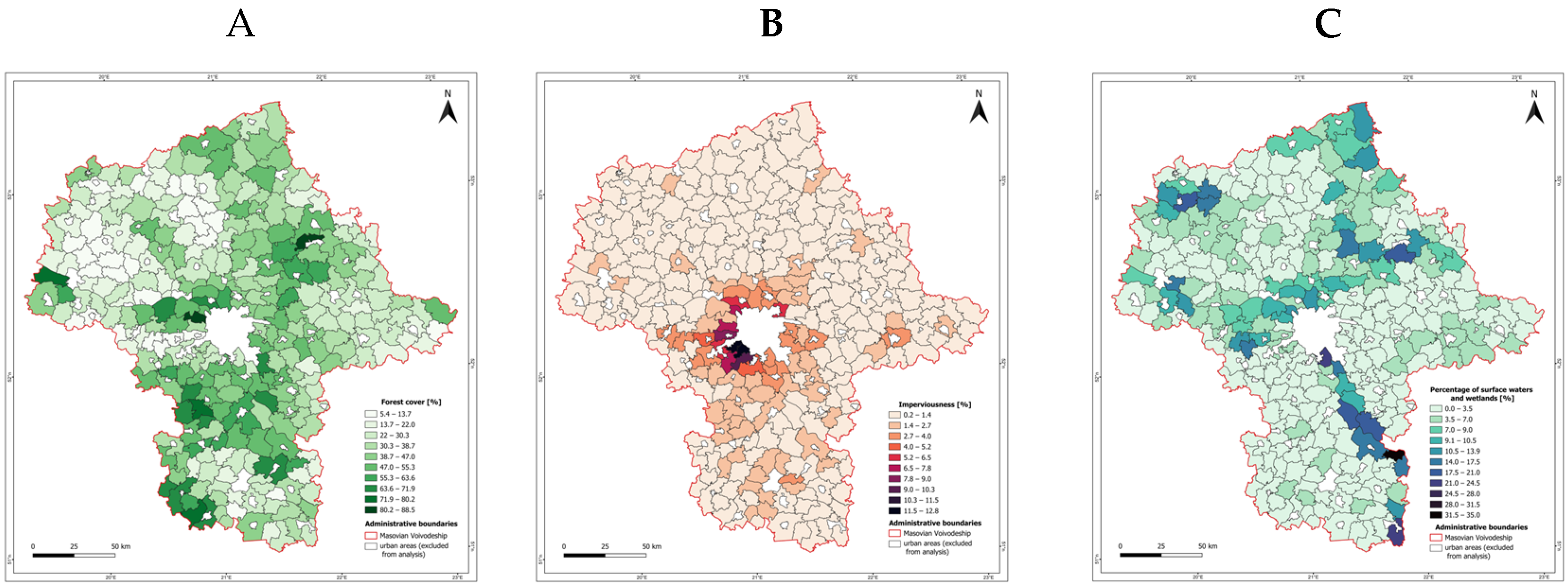
| HRL Forest Type | EEA38 and the UK | 2012, 2015, 2018 | 3 years | 10 m, 20 m, 100 m | EEA | Copernicus LMS [19] |
| HRL Small Woody Features | EEA38 and the UK | 2015, 2018 | 3 years | 5 m, 100 m | EEA | Copernicus LMS [20] |
| HRL Tree Cover Density | EEA38 and the UK | 2015, 2018 | 3 years | 10 m, 20 m, 100 m | EEA | Copernicus LMS [21] |
| HRL Water and Wetness | EEA38 and the UK | 2015, 2018 | 3 years | 20 m, 100 m | EEA | Copernicus LMS [22] |
| HRL Imperviousness | EEA38 and the UK | 2006, 2009, 2012, 2015, 2018 | 3 years | 10 m, 20 m, 100 m | EEA | Copernicus LMS [23] |
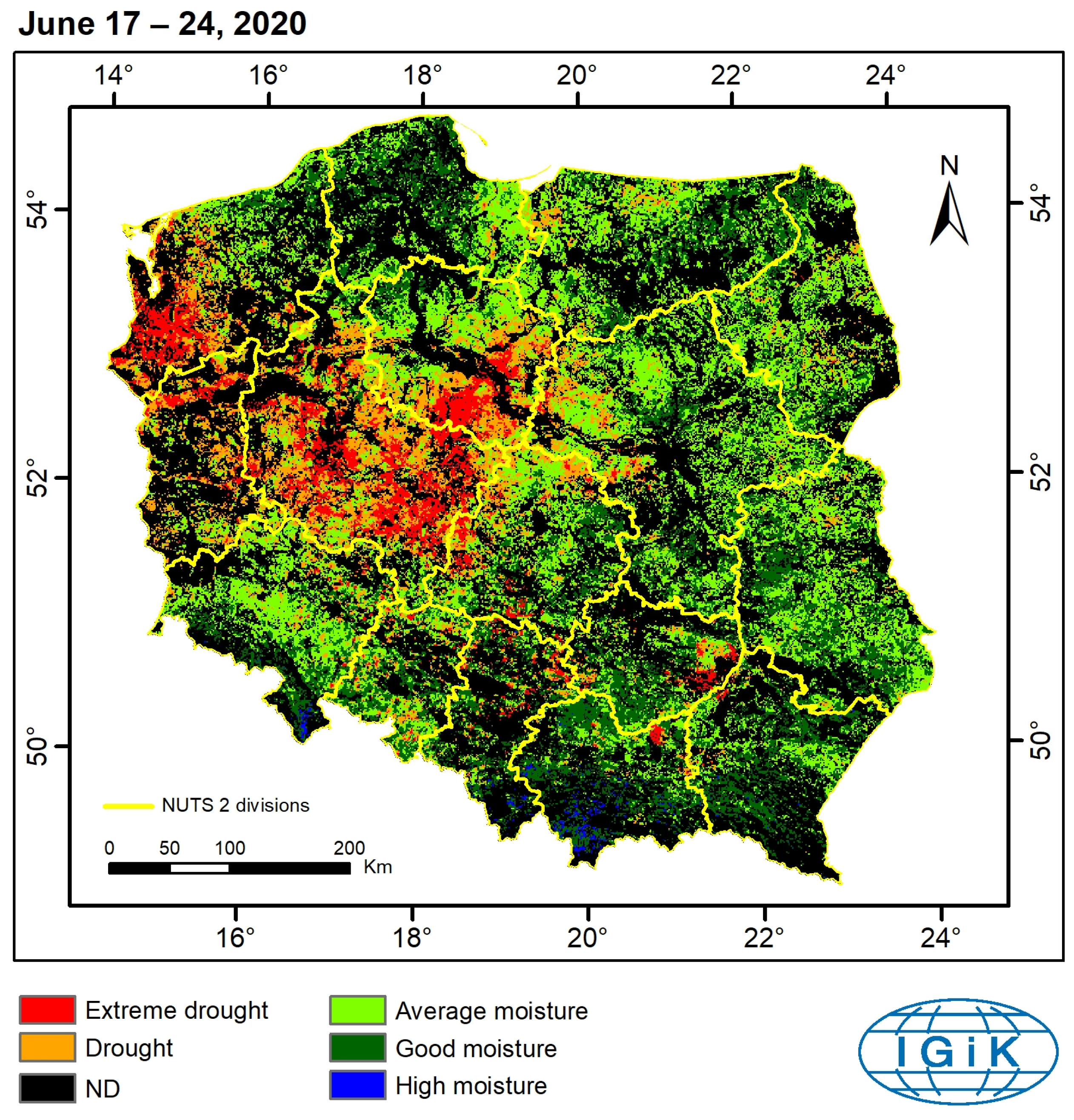
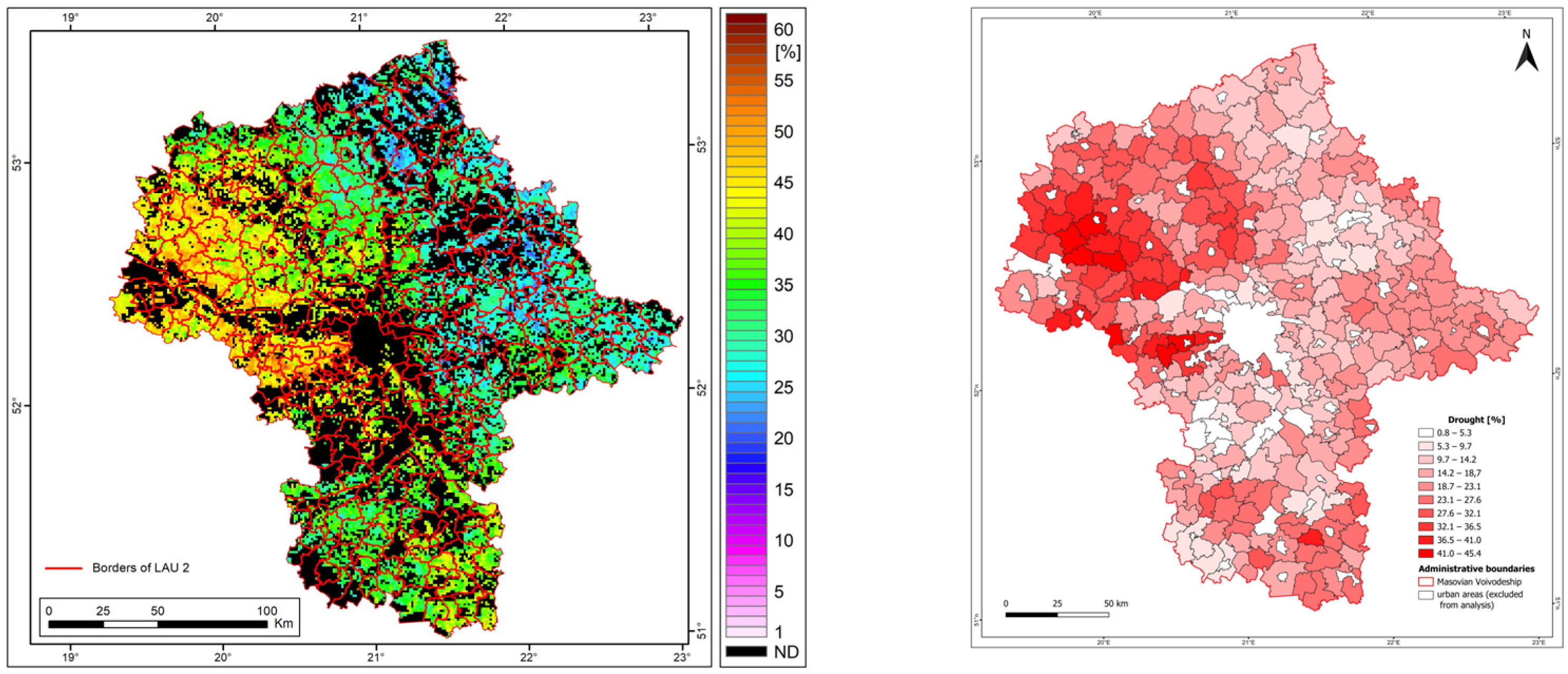
| Drought | Poland | 2001–2020 | Yearly | 1000 m | IGiK | On demand [24] |
| Administrative units LAU 2 | EU-27 and EFTA | 2021 | 3 years | Vector-Scale 01M | Eurostat | European Commission [25] |
| DISS | ||
|---|---|---|
| Value | Active Surface Moisture Class | Probability of Precipitation Deficit Occurrence in Agricultural Areas |
| Below 0.5 | extreme drought | 82.5% |
| (<0.5, 0.8) | drought | 70.0% |
| (<0.8, 1.3) | average | 49.0% |
| (<1.3, 2.0) | good | 29.6% |
| Above 2.0 | high | 17.0% |
| Factor | Criterion | Weight | Description |
|---|---|---|---|
| Forest Cover | Index < 30% | 1 | Areas with forest cover below the regional average |
| Surface Water & Wetlands | Proportion < Voivodeship Average | 1 | Areas with a deficit of water and wetland ecosystems compared to the regional average |
| Impervious Surfaces | Proportion > Voivodeship Average | 1 | Areas with excessive urbanization and hardened surfaces |
| Drought Frequency | μ ≤ x < μ + σ | 1 | Values within one standard deviation |
| Drought Frequency | x ≥ μ + σ | 2 | Values exceeding one standard deviation |
| Summary Statistics | Mann–Whitney Test | |||
|---|---|---|---|---|
| Variable | Drought occurrence (%) | Forest cover (%) | U | 18,628 |
| Observations by LAU 2 | 279 | 279 | U (standardized) | −10.656 |
| Minimum | 0.860 | 5.409 | Expected value | 38,920.500 |
| Maximum | 45.047 | 88.540 | Variance (U) | 3,626,093.250 |
| Mean | 20.301 | 34.146 | p-value (Two-tailed) | <0.0001 |
| Std. deviation | 9.244 | 9.244 | alpha | 0.0001 |
Disclaimer/Publisher’s Note: The statements, opinions and data contained in all publications are solely those of the individual author(s) and contributor(s) and not of MDPI and/or the editor(s). MDPI and/or the editor(s) disclaim responsibility for any injury to people or property resulting from any ideas, methods, instructions or products referred to in the content. |
© 2025 by the authors. Licensee MDPI, Basel, Switzerland. This article is an open access article distributed under the terms and conditions of the Creative Commons Attribution (CC BY) license (https://creativecommons.org/licenses/by/4.0/).
Share and Cite
Łągiewska, M.; Bartold, M. An Integrated Approach Using Remote Sensing and Multi-Criteria Decision Analysis to Mitigate Agricultural Drought Impact in the Mazowieckie Voivodeship, Poland. Remote Sens. 2025, 17, 1158. https://doi.org/10.3390/rs17071158
Łągiewska M, Bartold M. An Integrated Approach Using Remote Sensing and Multi-Criteria Decision Analysis to Mitigate Agricultural Drought Impact in the Mazowieckie Voivodeship, Poland. Remote Sensing. 2025; 17(7):1158. https://doi.org/10.3390/rs17071158
Chicago/Turabian StyleŁągiewska, Magdalena, and Maciej Bartold. 2025. "An Integrated Approach Using Remote Sensing and Multi-Criteria Decision Analysis to Mitigate Agricultural Drought Impact in the Mazowieckie Voivodeship, Poland" Remote Sensing 17, no. 7: 1158. https://doi.org/10.3390/rs17071158
APA StyleŁągiewska, M., & Bartold, M. (2025). An Integrated Approach Using Remote Sensing and Multi-Criteria Decision Analysis to Mitigate Agricultural Drought Impact in the Mazowieckie Voivodeship, Poland. Remote Sensing, 17(7), 1158. https://doi.org/10.3390/rs17071158


