Spatial Distribution Pattern of Forests in Yunnan Province in 2022: Analysis Based on Multi-Source Remote Sensing Data and Machine Learning
Abstract
1. Introduction
2. Materials and Methods
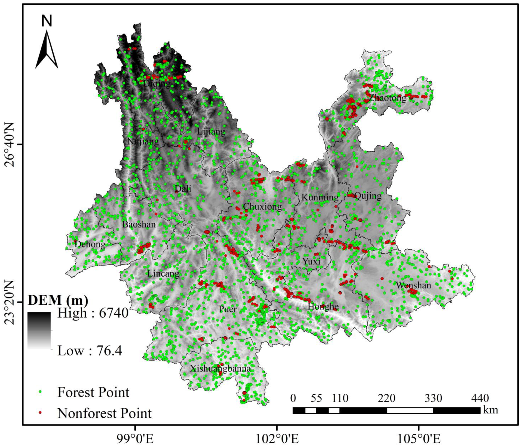
2.1. Study Area
2.2. Data Sources and Preprocessing
2.2.1. Satellite Imagery and Preprocessing
2.2.2. Digital Elevation Model (DEM)
2.3. Land Cover Data and Processing
2.4. Methods
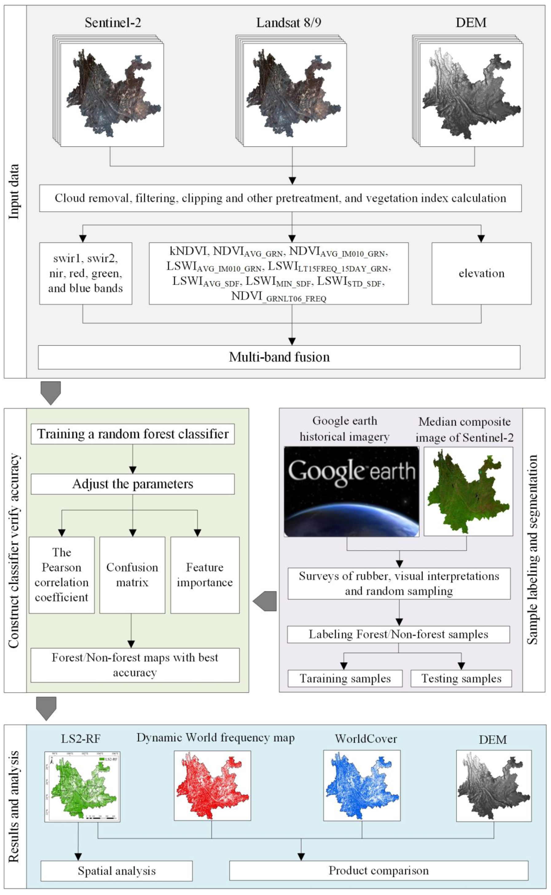
2.4.1. Technology Roadmap
2.4.2. Construction of Classification Features
2.4.3. Ground Samples
2.4.4. Algorithm for Classification
2.4.5. The Method of Feature Importance
2.4.6. The Pearson Correlation Coefficient
2.4.7. Accuracy Assessment and Product Comparison
2.4.8. Analysis of Forest Spatial Distribution Patterns
3. Results
3.1. Accuracy Assessment
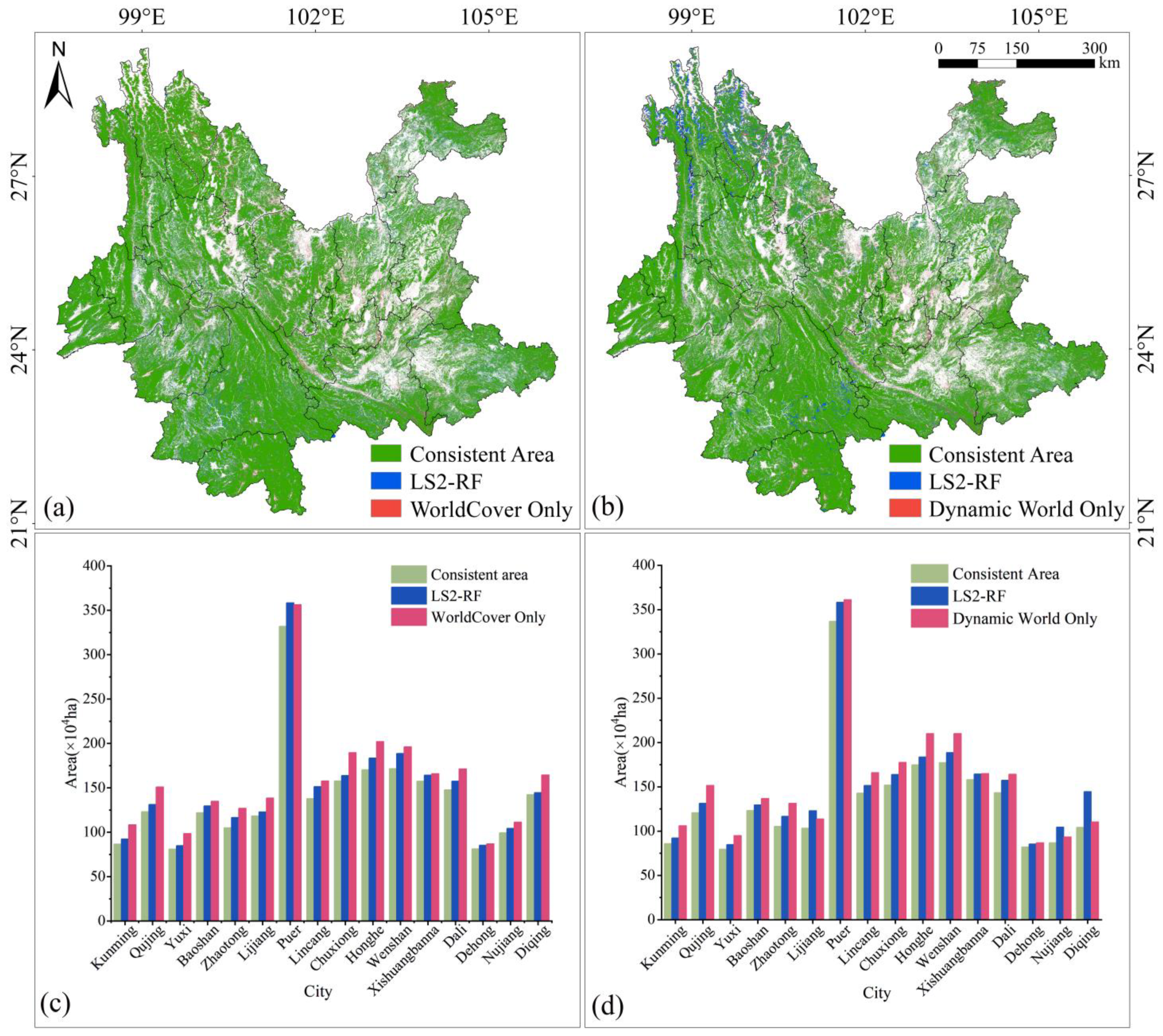
3.2. Spatial and Areal Comparison of Different Forest Products
3.3. Forest Spatial Distribution Characteristics
4. Discussion
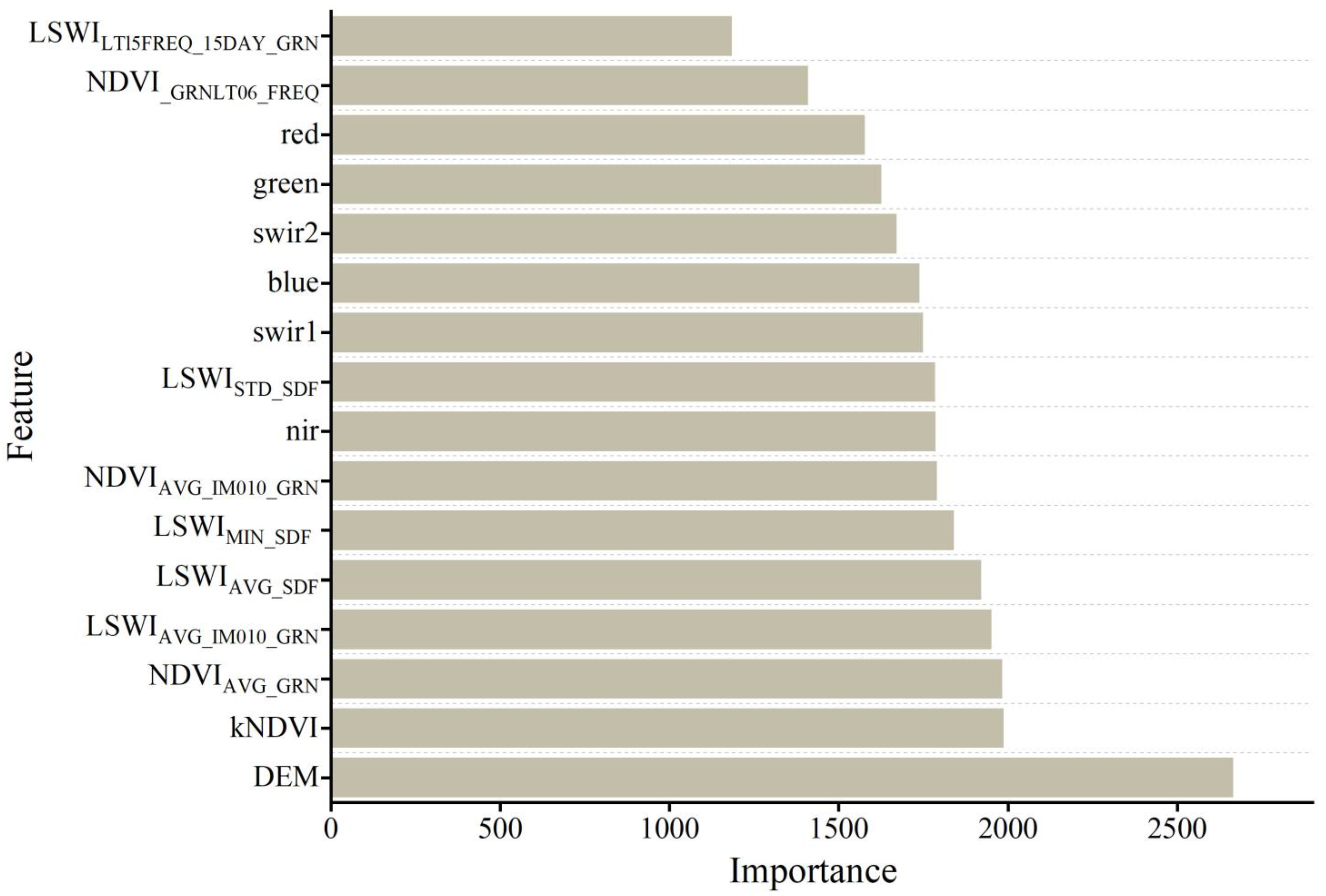
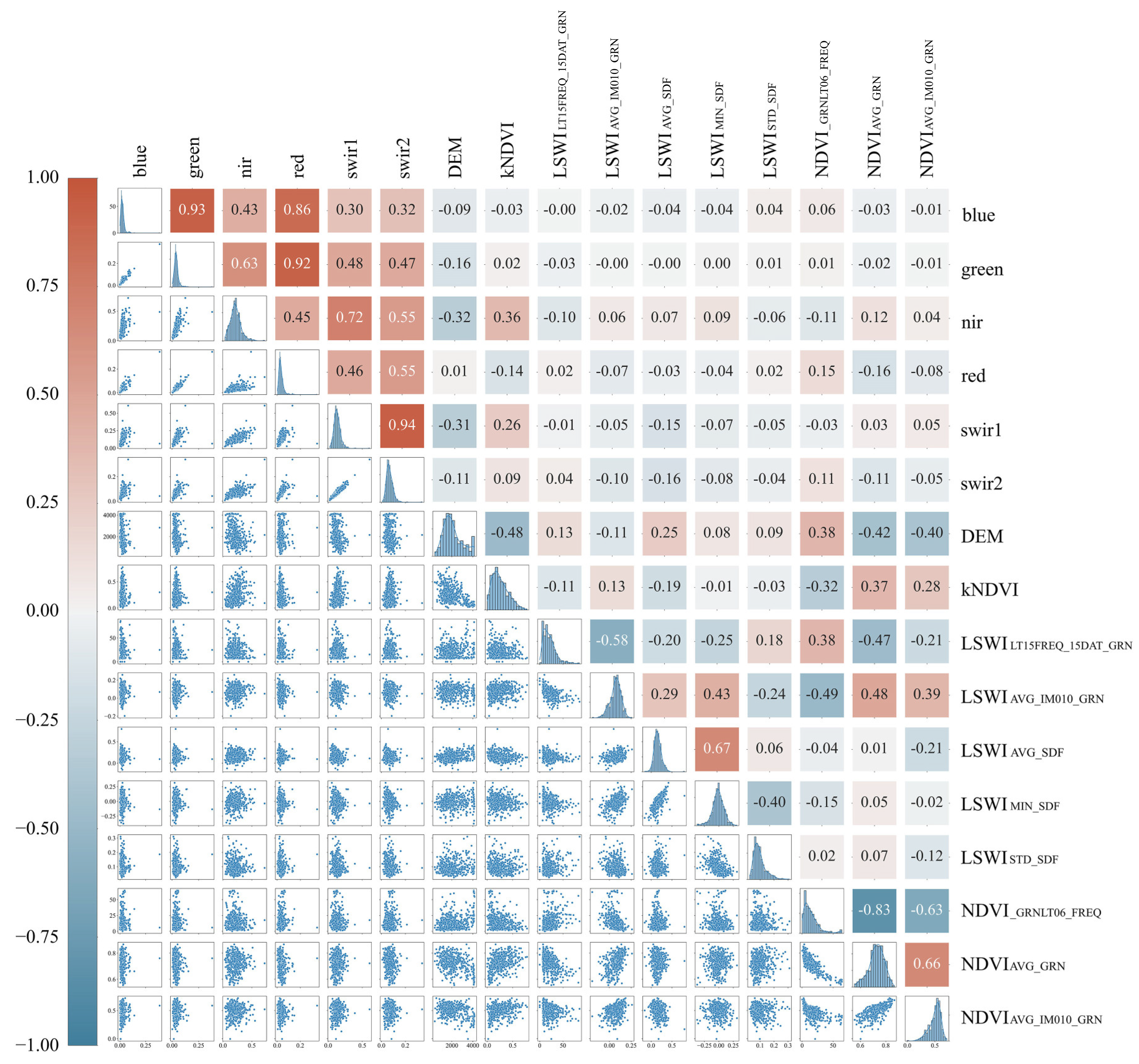
4.1. Feature Importance and Correlation Analysis
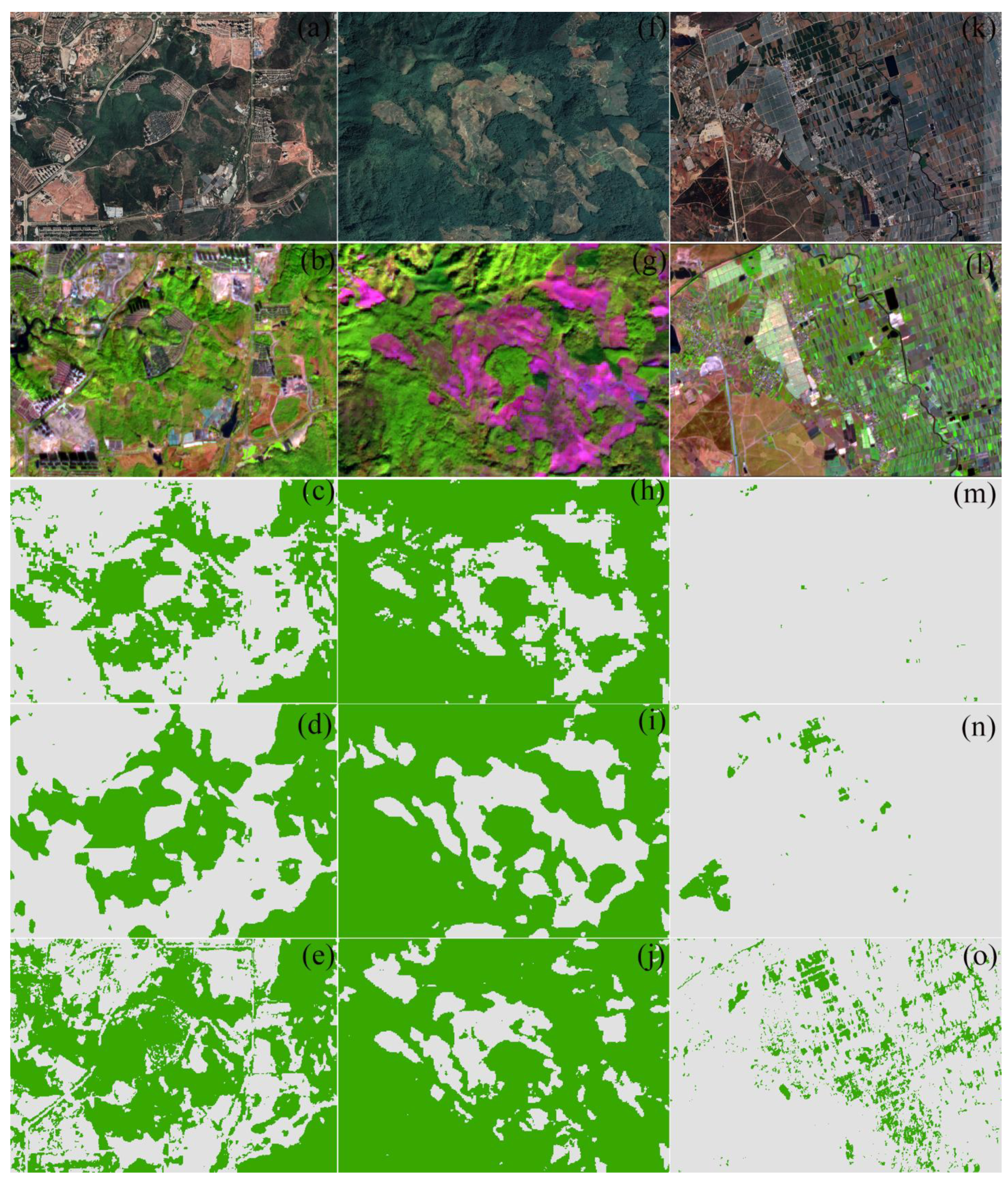
4.2. Comparative Spatial Analysis of Forest Cover Datasets
4.3. Patterns of Forest Distribution in Yunnan Province
5. Conclusions
Author Contributions
Funding
Data Availability Statement
Conflicts of Interest
References
- Bonan, G.B. Forests and Climate Change: Forcings, Feedbacks, and the Climate Benefits of Forests. Science 2008, 320, 1444–1449. [Google Scholar] [CrossRef]
- Debebe, B.; Senbeta, F.; Teferi, E.; Diriba, D.; Teketay, D. Analysis of Forest Cover Change and Its Drivers in Biodiversity Hotspot Areas of the Semien Mountains National Park, Northwest Ethiopia. Sustainability 2023, 15, 3001. [Google Scholar] [CrossRef]
- Moradi, E.; Sharifi, A. Assessment of forest cover changes using multi-temporal Landsat observation. Environ. Dev. Sustain. 2023, 25, 1351–1360. [Google Scholar] [CrossRef]
- Zeng, Z.; Estes, L.; Ziegler, A.D.; Chen, A.; Searchinger, T.; Hua, F.; Guan, K.; Jintrawet, A.; Wood, E.F. Highland cropland expansion and forest loss in Southeast Asia in the twenty-first century. Nat. Geosci. 2018, 11, 556–562. [Google Scholar] [CrossRef]
- Zhao, Z.; Li, W.; Ciais, P.; Santoro, M.; Cartus, O.; Peng, S.; Yin, Y.; Yue, C.; Yang, H.; Yu, L.; et al. Fire enhances forest degradation within forest edge zones in Africa. Nat. Geosci. 2021, 14, 479–483. [Google Scholar] [CrossRef]
- Mbow, C.; Smith, P.; Skole, D.; Duguma, L.; Bustamante, M. Achieving mitigation and adaptation to climate change through sustainable agroforestry practices in Africa. Curr. Opin. Environ. Sustain. 2014, 6, 8–14. [Google Scholar] [CrossRef]
- Wang, R.; Ding, X.; Yi, B.; Wang, J. Spatiotemporal characteristics of vegetation cover change in the Central Yunnan urban agglomeration from 2000 to 2020 based on Landsat data and its driving factors. Geocarto Int. 2024, 39, 2316643. [Google Scholar] [CrossRef]
- Hościło, A.; Lewandowska, A. Mapping Forest Type and Tree Species on a Regional Scale Using Multi-Temporal Sentinel-2 Data. Remote Sens. 2019, 11, 929. [Google Scholar] [CrossRef]
- Loveland, T.R.; Reed, B.C.; Brown, J.F.; Ohlen, D.O.; Zhu, Z.; Yang, L.; Merchant, J.W. Development of a global land cover characteristics database and IGBP DISCover from 1 km AVHRR data. Int. J. Remote Sens. 2000, 21, 1303–1330. [Google Scholar] [CrossRef]
- Hansen, M.C.; Defries, R.S.; Townshend, J.R.G.; Sohlberg, R. Global land cover classification at 1 km spatial resolution using a classification tree approach. Int. J. Remote Sens. 2000, 21, 1331–1364. [Google Scholar] [CrossRef]
- Friedl, M.A.; McIver, D.K.; Hodges, J.C.F.; Zhang, X.Y.; Muchoney, D.; Strahler, A.H.; Woodcock, C.E.; Gopal, S.; Schneider, A.; Cooper, A.; et al. Global land cover mapping from MODIS: Algorithms and early results. Remote Sens. Environ. 2002, 83, 287–302. [Google Scholar] [CrossRef]
- Gong, P.; Wang, J.; Yu, L.; Zhao, Y.; Zhao, Y.; Liang, L.; Chen, J. Finer resolution observation and monitoring of global land cover: First mapping results with Landsat TM and ETM+ data. Int. J. Remote Sens. 2013, 34, 2607–2654. [Google Scholar] [CrossRef]
- Brown, C.F.; Brumby, S.P.; Guzder-Williams, B.; Birch, T.; Hyde, S.B.; Mazzariello, J.; Czerwinski, W.; Pasquarella, V.J.; Haertel, R.; Ilyushchenko, S.; et al. Dynamic World, Near real-time global 10 m land use land cover mapping. Sci. Data 2022, 9, 251. [Google Scholar] [CrossRef]
- Kim, D.; Sexton, J.O.; Noojipady, P.; Huang, C.; Anand, A.; Channan, S.; Feng, M.; Townshend, J.R. Global, Landsat-based forest-cover change from 1990 to 2000. Remote Sens. Environ. 2014, 155, 178–193. [Google Scholar] [CrossRef]
- Hansen, M.C.; Potapov, P.V.; Moore, R.; Hancher, M.; Turubanova, S.A.; Tyukavina, A.; Thau, D.; Stehman, S.V.; Goetz, S.J.; Loveland, T.R.; et al. High-resolution global maps of 21st-century forest cover change. Science 2013, 342, 850–853. [Google Scholar] [CrossRef] [PubMed]
- Lang, N.; Jetz, W.; Schindler, K.; Wegner, J.D. A high-resolution canopy height model of the Earth. Nat. Ecol. Evol. 2023, 7, 1778–1789. [Google Scholar] [CrossRef]
- Tolan, J.; Yang, H.; Nosarzewski, B.; Couairon, G.; Vo, H.V.; Brandt, J.; Spore, J.; Majumdar, S.; Haziza, D.; Vamaraju, J.; et al. Very high resolution canopy height maps from RGB imagery using self-supervised vision transformer and convolutional decoder trained on aerial lidar. Remote Sens. Environ. 2024, 300, 113888. [Google Scholar] [CrossRef]
- Wang, Y.; Sun, Y.; Cao, X.; Wang, Y.; Zhang, W.; Cheng, X. A review of regional and Global scale Land Use/Land Cover (LULC) mapping products generated from satellite remote sensing. Isprs-J. Photogramm. Remote Sens. 2023, 206, 311–334. [Google Scholar] [CrossRef]
- Zhang, W.; Tian, J.; Zhang, X.; Cheng, J.; Yan, Y. Which land cover product provides the most accurate land use land cover map of the Yellow River Basin? Front. Ecol. Evol. 2023, 11, 1275054. [Google Scholar] [CrossRef]
- Aulia, O.D.; Apriani, I.; Juanda, A.; Barri, M.F.; Dewi, R.W.; Muharam, F.N.; Oktanine, B.; Phoa, T.B.; Condro, A.A. Refining National Forest Cover Data Based on Fusion Optical Satellite Imageries in Indonesia. Int. J. For. Res. 2023, 2023, 1–11. [Google Scholar] [CrossRef]
- Yang, F.; Jiang, X.; Ziegler, A.D.; Estes, L.D.; Wu, J.; Chen, A.; Ciais, P.; Wu, J.; Zeng, Z. Improved Fine-Scale Tropical Forest Cover Mapping for Southeast Asia Using Planet-NICFI and Sentinel-1 Imagery. J. Remote Sens. 2023, 3, 0064. [Google Scholar] [CrossRef]
- Yu, X.; Lu, D.; Jiang, X.; Li, G.; Chen, Y.; Li, D.; Chen, E. Examining the Roles of Spectral, Spatial, and Topographic Features in Improving Land-Cover and Forest Classifications in a Subtropical Region. Remote Sens. 2020, 12, 2907. [Google Scholar] [CrossRef]
- Li, R.; Xia, H.; Zhao, X.; Guo, Y. Mapping evergreen forests using new phenology index, time series Sentinel-1/2 and Google Earth Engine. Ecol. Indic. 2023, 149, 110157. [Google Scholar] [CrossRef]
- Cai, Y.; Xu, X.; Zhu, P.; Nie, S.; Wang, C.; Xiong, Y.; Liu, X. Unveiling spatiotemporal tree cover patterns in China: The first 30 m annual tree cover mapping from 1985 to 2023. Isprs-J. Photogramm. Remote Sens. 2024, 216, 240–258. [Google Scholar] [CrossRef]
- Purwanto, A.D.; Wikantika, K.; Deliar, A.; Darmawan, S. Decision Tree and Random Forest Classification Algorithms for Mangrove Forest Mapping in Sembilang National Park, Indonesia. Remote Sens. 2023, 15, 16. [Google Scholar] [CrossRef]
- Zagajewski, B.; Kluczek, M.; Raczko, E.; Njegovec, A.; Dabija, A.; Kycko, M. Comparison of Random Forest, Support Vector Machines, and Neural Networks for Post-Disaster Forest Species Mapping of the Krkonoše/Karkonosze Transboundary Biosphere Reserve. Remote Sens. 2021, 13, 2581. [Google Scholar] [CrossRef]
- Mohajane, M.; Costache, R.; Karimi, F.; Bao Pham, Q.; Essahlaoui, A.; Nguyen, H.; Laneve, G.; Oudija, F. Application of remote sensing and machine learning algorithms for forest fire mapping in a Mediterranean area. Ecol. Indic. 2021, 129, 107869. [Google Scholar] [CrossRef]
- Liu, X.; Liang, S.; Li, B.; Ma, H.; He, T. Mapping 30 m Fractional Forest Cover over China’s Three-North Region from Landsat-8 Data Using Ensemble Machine Learning Methods. Remote Sens. 2021, 13, 2592. [Google Scholar] [CrossRef]
- Wang, X.; Zhang, Y.; Zhang, K. Automatic 10 m Forest Cover Mapping in 2020 at China’s Han River Basin by Fusing ESA Sentinel-1/Sentinel-2 Land Cover and Sentinel-2 near Real-Time Forest Cover Possibility. Forests 2023, 14, 1133. [Google Scholar] [CrossRef]
- Nguyen, T.; Kellenberger, B.; Tuia, D. Mapping forest in the Swiss Alps treeline ecotone with explainable deep learning. Remote Sens. Environ. 2022, 281, 113217. [Google Scholar] [CrossRef]
- Zhu, R.; Shen, W.; Zhang, Y.; Li, M. Assessing changes in forest coverage and forest fragmentation patterns in Yunnan Province from time series MODIS-VCF products (2000–2016). J. Nanjing For. Univ. 2019, 62, 184. [Google Scholar]
- Li, J.; Wang, L.; Fang, P.; Xu, W.; Dai, Q. Forest Type Mapping at a Regional Scale Based Using Multitemporal Sentinel-2 Imagery. In Proceedings of the 2021 IEEE International Geoscience and Remote Sensing Symposium IGARSS, Brussels, Belgium, 11–16 July 2021; pp. 4228–4231. [Google Scholar]
- Li, R.; Fang, P.; Xu, W.; Wang, L.; Ou, G.; Zhang, W.; Huang, X. Classifying Forest Types over a Mountainous Area in Southwest China with Landsat Data Composites and Multiple Environmental Factors. Forests 2022, 13, 135. [Google Scholar] [CrossRef]
- Huang, T.; Ou, G.; Wu, Y.; Zhang, X.; Liu, Z.; Xu, H.; Xu, X.; Wang, Z.; Xu, C. Estimating the Aboveground Biomass of Various Forest Types with High Heterogeneity at the Provincial Scale Based on Multi-Source Data. Remote Sens. 2023, 15, 3550. [Google Scholar] [CrossRef]
- Zhang, Y.; Ling, F.; Foody, G.M.; Ge, Y.; Boyd, D.S.; Li, X.; Du, Y.; Atkinson, P.M. Mapping annual forest cover by fusing PALSAR/PALSAR-2 and MODIS NDVI during 2007–2016. Remote Sens. Environ. 2019, 224, 74–91. [Google Scholar] [CrossRef]
- Song, X.; Cao, M.; Li, J.; Kitching, R.L.; Nakamura, A.; Laidlaw, M.J.; Tang, Y.; Sun, Z.; Zhang, W.; Yang, J. Different environmental factors drive tree species diversity along elevation gradients in three climatic zones in Yunnan, southern China. Plant Divers. 2021, 43, 433–443. [Google Scholar] [CrossRef]
- Zhu, Z.; Deng, X.; Zhao, F.; Li, S.; Wang, L. How Environmental Factors Affect Forest Fire Occurrence in Yunnan Forest Region. Forests 2022, 13, 1392. [Google Scholar] [CrossRef]
- Shi, Y.; Feng, C.; Yang, S. Predictive Modeling of Forest Fires in Yunnan Province: An Integration of ARIMA and Stepwise Regression Analysis. Appl. Sci. 2024, 14, 256. [Google Scholar] [CrossRef]
- Zanaga, D.; Van De Kerchove, R.; Daems, D.; De Keersmaecker, W.; Brockmann, C.; Kirches, G.; Wevers, J.; Cartus, O.; Santoro, M.; Fritz, S.; et al. ESA WorldCover 10 m 2021 v200. 2022. Available online: https://pure.iiasa.ac.at/id/eprint/18478/ (accessed on 22 October 2023).
- Lü, F.; Song, Y.; Yan, X. Evaluating Carbon Sink Potential of Forest Ecosystems under Different Climate Change Scenarios in Yunnan, Southwest China. Remote Sens. 2023, 15, 1442. [Google Scholar] [CrossRef]
- Pasquarella, V.J.; Brown, C.F.; Czerwinski, W.; Rucklidge, W.J. Comprehensive quality assessment of optical satellite imagery using weakly supervised video learning. In Proceedings of the IEEE/CVF Conference on Computer Vision and Pattern Recognition (CVPR) Workshops, Vancouver, BC, Canada, 17–24 June 2023; pp. 2125–2135. [Google Scholar]
- Rouse, J.W.; Haas, R.H.; Schell, J.A.E.A. Monitoring vegetation systems in the Great Plains with ERTS. Nasa Spec. Publ. 1974, 351, 309. [Google Scholar]
- Camps-Valls, G.; Campos-Taberner, M.; Moreno-Martinez, A.; Walther, S.; Duveiller, G.; Cescatti, A.; Mahecha, M.D.; Munoz-Mari, J.; Garcia-Haro, F.J.; Guanter, L.; et al. A unified vegetation index for quantifying the terrestrial biosphere. Sci. Adv. 2021, 7, eabc7447. [Google Scholar] [CrossRef]
- Farr, T.G.; Rosen, P.A.; Caro, E.; Crippen, R.; Duren, R.; Hensley, S.; Kobrick, M.; Paller, M.; Rodriguez, E.; Roth, L.; et al. The Shuttle Radar Topography Mission. Rev. Geophys. 2007, 45. [Google Scholar] [CrossRef]
- Chen, B.; Xiao, X.; Ye, H.; Ma, J.; Doughty, R.; Li, X.; Zhao, B.; Wu, Z.; Sun, R.; Dong, J.; et al. Mapping Forest and Their Spatial–Temporal Changes From 2007 to 2015 in Tropical Hainan Island by Integrating ALOSALOS-2 L-Band SAR and Landsat Optical Images. IEEE J. Sel. Top. Appl. Earth Observ. Remote Sens. 2018, 11, 852–867. [Google Scholar] [CrossRef]
- Zhai, D.; Dong, J.; Cadisch, G.; Wang, M.; Kou, W.; Xu, J.; Xiao, X.; Abbas, S. Comparison of Pixel- and Object-Based Approaches in Phenology-Based Rubber Plantation Mapping in Fragmented Landscapes. Remote Sens. 2018, 10, 44. [Google Scholar] [CrossRef]
- Chen, B.; Li, X.; Xiao, X.; Zhao, B.; Dong, J.; Kou, W.; Qin, Y.; Yang, C.; Wu, Z.; Sun, R.; et al. Mapping tropical forests and deciduous rubber plantations in Hainan Island, China by integrating PALSAR 25-m and multi-temporal Landsat images. Int. J. Appl. Earth Obs. Geoinf. 2016, 50, 117–130. [Google Scholar]
- Meng, S.; Pang, Y.; Huang, C.; Li, Z. Improved forest cover mapping by harmonizing multiple land cover products over China. Gisci. Remote Sens. 2022, 1, 1570–1597. [Google Scholar] [CrossRef]
- Camargo, F.F.; Sano, E.E.; Almeida, C.M.; Mura, J.C.; Almeida, T. A Comparative Assessment of Machine-Learning Techniques for Land Use and Land Cover Classification of the Brazilian Tropical Savanna Using ALOS-2/PALSAR-2 Polarimetric Images. Remote Sens. 2019, 11, 1600. [Google Scholar] [CrossRef]
- Ma, L.; Li, M.; Ma, X.; Cheng, L.; Du, P.; Liu, Y. A review of supervised object-based land-cover image classification. Isprs-J. Photogramm. Remote Sens. 2017, 130, 277–293. [Google Scholar] [CrossRef]
- Talukdar, S.; Singha, P.; Mahato, S.; Pal, S.; Liou, Y.A.; Rahman, A. Land-Use Land-Cover Classification by Machine Learning Classifiers for Satellite Observations—A Review. Remote Sens. 2020, 12, 1135. [Google Scholar] [CrossRef]
- Guo, Q.; Zhang, J.; Guo, S.; Ye, Z.; Deng, H.; Hou, X.; Zhang, H. Urban Tree Classification Based on Object-Oriented Approach and Random Forest Algorithm Using Unmanned Aerial Vehicle (UAV) Multispectral Imagery. Remote Sens. 2022, 14, 3885. [Google Scholar] [CrossRef]
- Breiman, L. Random forests. Mach. Learn. 2001, 45, 5–32. [Google Scholar] [CrossRef]
- Baudoux, L.; Inglada, J.; Mallet, C. Toward a Yearly Country-Scale CORINE Land-Cover Map without Using Images: A Map Translation Approach. Remote Sens. 2021, 13, 1060. [Google Scholar] [CrossRef]
- Dobrinić, D.; Gašparović, M.; Medak, D. Sentinel-1 and 2 Time-Series for Vegetation Mapping Using Random Forest Classification: A Case Study of Northern Croatia. Remote Sens. 2021, 13, 2321. [Google Scholar] [CrossRef]
- Zhao, Y.; Zhu, W.; Wei, P.; Fang, P.; Zhang, X.; Yan, N.; Liu, W.; Zhao, H.; Wu, Q. Classification of Zambian grasslands using random forest feature importance selection during the optimal phenological period. Ecol. Indic. 2022, 135, 108529. [Google Scholar] [CrossRef]
- Genuer, R.; Poggi, J.; Tuleau-Malot, C. Variable selection using random forests. Pattern Recognit. Lett. 2010, 31, 2225–2236. [Google Scholar] [CrossRef]
- Mei, K.; Tan, M.; Yang, Z.; Shi, S. Modeling of Feature Selection Based on Random Forest Algorithm and Pearson Correlation Coefficient. J. Phys. Conf. Ser. 2022, 2219, 12046. [Google Scholar] [CrossRef]
- Caelen, O. A Bayesian Interpretation of the Confusion Matrix. Ann. Math. Artif. Intell. 2017, 81, 429–450. [Google Scholar] [CrossRef]
- Liu, Y.; Gong, W.; Hu, X.; Gong, J. Forest Type Identification with Random Forest Using Sentinel-1A, Sentinel-2A, Multi-Temporal Landsat-8 and DEM Data. Remote Sens. 2018, 10, 946. [Google Scholar] [CrossRef]
- Hörsch, B. Modelling the spatial distribution of montane and subalpine forests in the central Alps using digital elevation models. Ecol. Model. 2003, 168, 267–282. [Google Scholar] [CrossRef]
- Misra, G.; Cawkwell, F.; Wingler, A. Status of Phenological Research Using Sentinel-2 Data: A Review. Remote Sens. 2020, 12, 2760. [Google Scholar] [CrossRef]
- Chen, Z.; Shi, D. Spatial Structure Characteristics of Slope Farmland Quality in Plateau Mountain Area: A Case Study of Yunnan Province, China. Sustainability 2020, 12, 7230. [Google Scholar] [CrossRef]
- Grainger, A. The Influence of End-Users on the Temporal Consistency of an International Statistical Process: The Case of Tropical Forest Statistics. J. Off. Stat. 2007, 23, 553–592. [Google Scholar]
- Keenan, R.J.; Reams, G.A.; Achard, F.; de Freitas, J.V.; Grainger, A.; Lindquist, E. Dynamics of global forest area: Results from the FAO Global Forest Resources Assessment 2015. For. Ecol. Manag. 2015, 352, 9–20. [Google Scholar] [CrossRef]
- Li, J.; Wang, J.; Zhang, J.; Zhang, J.; Kong, H. Dynamic changes of vegetation coverage in China-Myanmar economic corridor over the past 20 years. Int. J. Appl. Earth Obs. Geoinf. 2021, 102, 102378. [Google Scholar] [CrossRef]
- Sarathchandra, C.; Alemu Abebe, Y.; Worthy, F.R.; Lakmali Wijerathne, I.; Ma, H.; Yingfeng, B.; Jiayu, G.; Chen, H.; Yan, Q.; Geng, Y.; et al. Impact of land use and land cover changes on carbon storage in rubber dominated tropical Xishuangbanna, South West China. Ecosyst. Health Sustain. 2021, 7, 1915183. [Google Scholar] [CrossRef]
- Li, W.; Xu, Q.; Yi, J.; Liu, J. Predictive model of spatial scale of forest fire driving factors: A case study of Yunnan Province, China. Sci. Rep. 2022, 12, 19029. [Google Scholar] [CrossRef]
- He, D.; Huang, X.; Tian, Q.; Zhang, Z. Changes in Vegetation Growth Dynamics and Relations with Climate in Inner Mongolia under More Strict Multiple Pre-Processing (2000–2018). Sustainability 2020, 12, 2534. [Google Scholar] [CrossRef]
- Chen, G.; Liu, Z.; Wen, Q.; Tan, R.; Wang, Y.; Zhao, J.; Feng, J. Identification of Rubber Plantations in Southwestern China Based on Multi-Source Remote Sensing Data and Phenology Windows. Remote Sens. 2023, 15, 1228. [Google Scholar] [CrossRef]
- Zhai, J.; Xiao, C.; Liu, X.; Liu, Y. Analysis of 10-m Sentinel-2 imagery and a re-normalization approach reveals a declining trend in the latest rubber plantations in Xishuangbanna. Adv. Space Res. 2024, 73, 5910–5924. [Google Scholar] [CrossRef]
- Tanner, H.M. The people’s liberation army and CHINA’s internal security challenges. In The Pla at Home and Abroad: Assessing the Operational Capabilities of China’S Military; Us Army War College Strategic Studies Institute: Carlisle Barracks, PA, USA, 2010; pp. 259–266. [Google Scholar]
- Zhang, B.; Luo, M.; Du, Q.; Yi, Z.; Dong, L.; Yu, Y.; Feng, J.; Lin, J. Spatial distribution and suitability evaluation of nighttime tourism in Kunming utilizing multi-source data. Heliyon 2023, 9, e16826. [Google Scholar] [CrossRef]
- Wang, Y.; Yue, X.; Li, C.; Wang, M.; Zhang, H.O.; Su, Y. Relationship between Urban Three-Dimensional Spatial Structure and Population Distribution: A Case Study of Kunming’s Main Urban District, China. Remote Sens. 2022, 14, 3757. [Google Scholar] [CrossRef]
- Zhang, Y.; Ai, J.; Sun, Q.; Li, Z.; Hou, L.; Song, L.; Tang, G.; Li, L.; Shao, G. Soil organic carbon and total nitrogen stocks as affected by vegetation types and altitude across the mountainous regions in the Yunnan Province, south-western China. Catena 2021, 196, 104872. [Google Scholar] [CrossRef]
- Yang, R.; He, Y.; Zhong, C.; Yang, Z.; Wang, X.; Xu, M.; Cao, L. Study on the Spatiotemporal Evolution and Influencing Factors of Forest Coverage Rate (FCR): A Case Study on Yunnan Province Based on Remote Sensing Image Interpretation. Forests 2024, 15, 238. [Google Scholar] [CrossRef]


| Products | LS2-RF | Dynamic World | WorldCover | |||
|---|---|---|---|---|---|---|
| Ground Truth Samples | Ground Truth Samples | Ground Truth Samples | ||||
| Classification | Forest | Non-Forest | Forest | Non-Forest | Forest | Non-Forest |
| Forest | 2900 | 67 | 1213 | 70 | 1262 | 21 |
| Non-Forest | 77 | 898 | 449 | 255 | 225 | 486 |
| Producer accuracy (%) | 97.74 | 92.10 | 94.54 | 36.22 | 98.36 | 68.35 |
| Omission error (%) | 2.26 | 7.90 | 5.46 | 63.78 | 1.64 | 31.65 |
| User accuracy (%) | 97.41 | 93.06 | 72.98 | 78.46 | 84.87 | 95.86 |
| Commission error | 2.59 | 6.94 | 27.02 | 21.54 | 15.13 | 4.14 |
| Overall accuracy (%) | 96.35 | 73.88 | 87.66 | |||
| Kappa coefficient | 0.9015 | 0.3502 | 0.7128 | |||
Disclaimer/Publisher’s Note: The statements, opinions and data contained in all publications are solely those of the individual author(s) and contributor(s) and not of MDPI and/or the editor(s). MDPI and/or the editor(s) disclaim responsibility for any injury to people or property resulting from any ideas, methods, instructions or products referred to in the content. |
© 2025 by the authors. Licensee MDPI, Basel, Switzerland. This article is an open access article distributed under the terms and conditions of the Creative Commons Attribution (CC BY) license (https://creativecommons.org/licenses/by/4.0/).
Share and Cite
Li, G.; Lai, H.; Chen, B.; Yin, X.; Kou, W.; Wu, Z.; Chen, Z.; Wang, G. Spatial Distribution Pattern of Forests in Yunnan Province in 2022: Analysis Based on Multi-Source Remote Sensing Data and Machine Learning. Remote Sens. 2025, 17, 1146. https://doi.org/10.3390/rs17071146
Li G, Lai H, Chen B, Yin X, Kou W, Wu Z, Chen Z, Wang G. Spatial Distribution Pattern of Forests in Yunnan Province in 2022: Analysis Based on Multi-Source Remote Sensing Data and Machine Learning. Remote Sensing. 2025; 17(7):1146. https://doi.org/10.3390/rs17071146
Chicago/Turabian StyleLi, Guangyang, Hongyan Lai, Bangqian Chen, Xiong Yin, Weili Kou, Zhixiang Wu, Zongzhu Chen, and Guizhen Wang. 2025. "Spatial Distribution Pattern of Forests in Yunnan Province in 2022: Analysis Based on Multi-Source Remote Sensing Data and Machine Learning" Remote Sensing 17, no. 7: 1146. https://doi.org/10.3390/rs17071146
APA StyleLi, G., Lai, H., Chen, B., Yin, X., Kou, W., Wu, Z., Chen, Z., & Wang, G. (2025). Spatial Distribution Pattern of Forests in Yunnan Province in 2022: Analysis Based on Multi-Source Remote Sensing Data and Machine Learning. Remote Sensing, 17(7), 1146. https://doi.org/10.3390/rs17071146


