


Assessing Classification Accuracy as a Criterion for Evaluating the Performance of Seven Topographic Correction Algorithms in the Trinidad Mountains, Cuba

 ,
,  ,
,  ,
,  and
and 
Abstract
1. Introduction
2. Materials and Methods
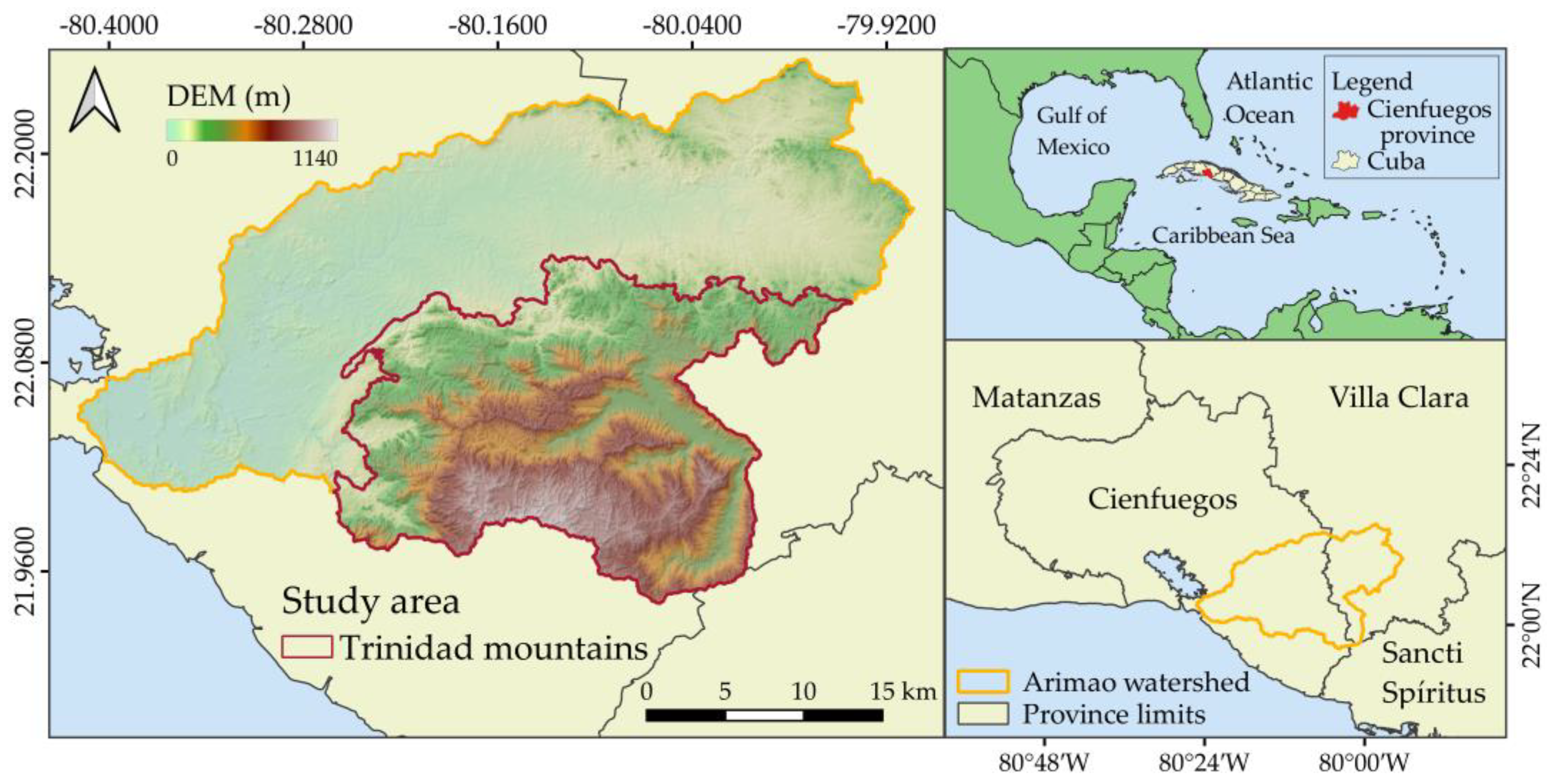
2.1. Study Area
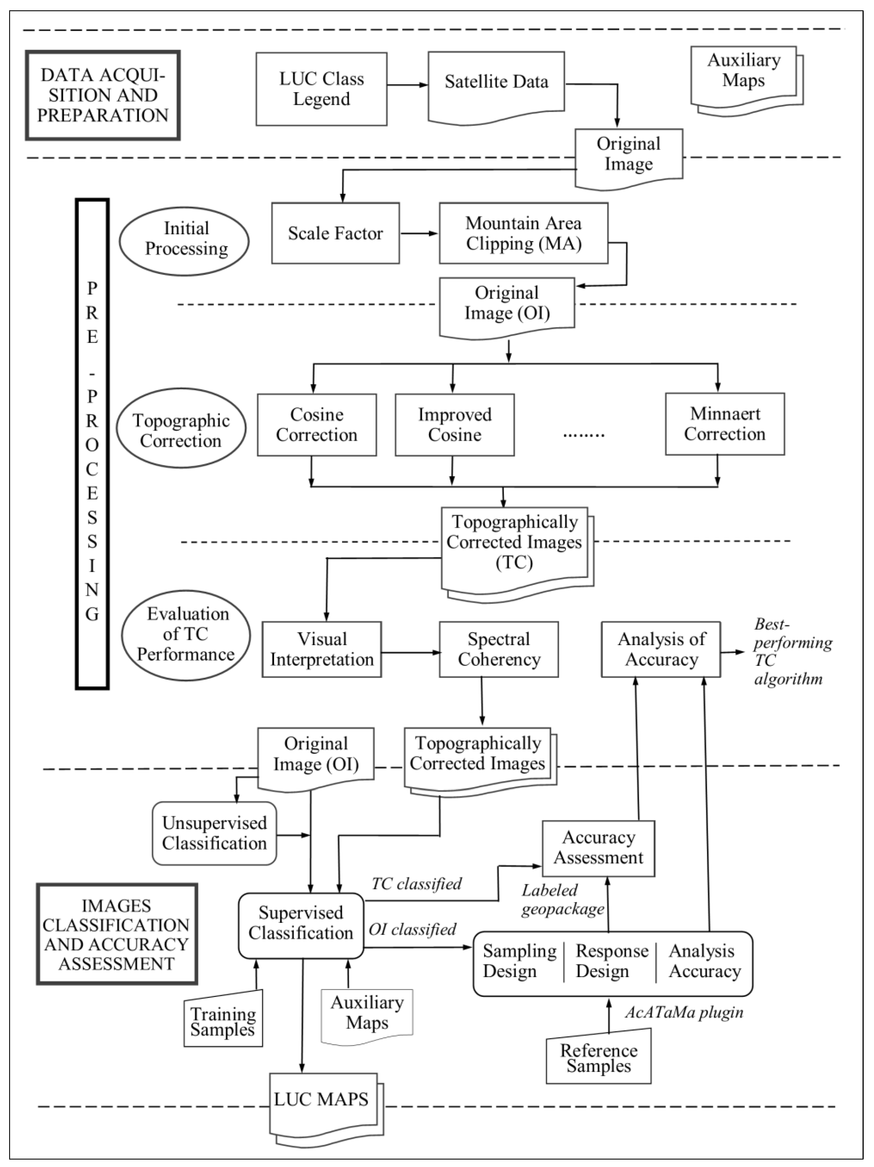
- Data acquisition and preparation—This initial stage involves acquiring and preparing numerical and geographic data, selecting the land user/cover legend, and downloading of the satellite images.
- Image pre-processing—In this stage, a scale factor was applied to all image bands. Additionally, seven topographic correction algorithms were implemented for the mountainous region and their accuracy was evaluated using various criteria.
- Images classification and accuracy assessment—The final stage begins with an unsupervised classification of the image that yielded the best spectral coherence. Preliminary results from these classifications were used to select training samples for supervised classification of the topographically corrected images. The accuracy of classification was assessed, and based on the results, the optimal topographic correction algorithm and land cover map were selected.
2.2. Data Acquisition and Preparation
2.2.1. Define the LUC Legend
2.2.2. Selection and Download of Landsat Images
2.2.3. Auxiliary Geographic Data
2.3. Mountain Area Clipping
2.4. Topographic Correction Algorithms
2.5. Performance Evaluation of the Topographic Correction Algorithms
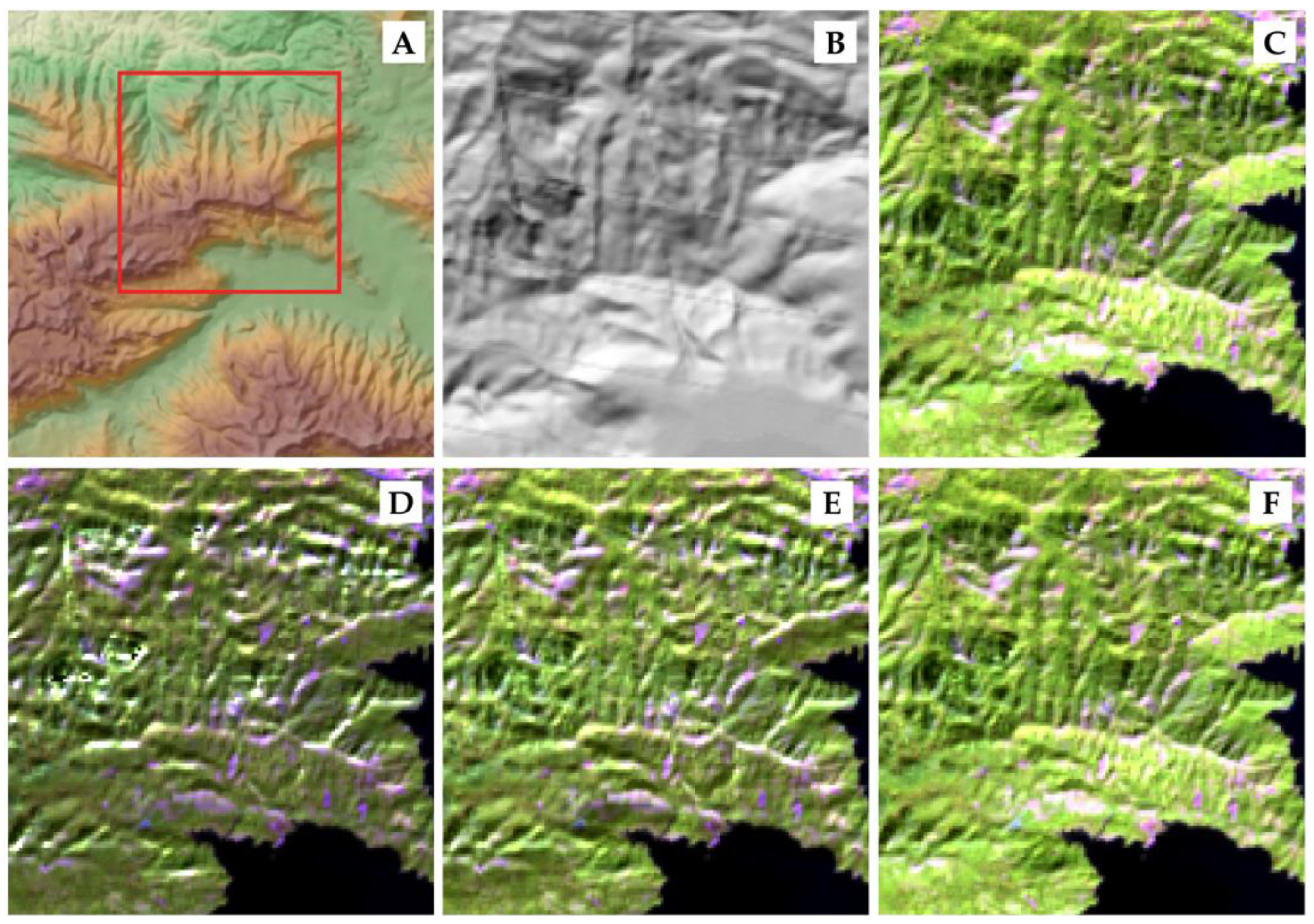
2.5.1. Visual Interpretation
2.5.2. Spectral Coherence
2.5.3. Assessing Classification Accuracy
2.6. Classification of Image
2.6.1. Unsupervised Classification
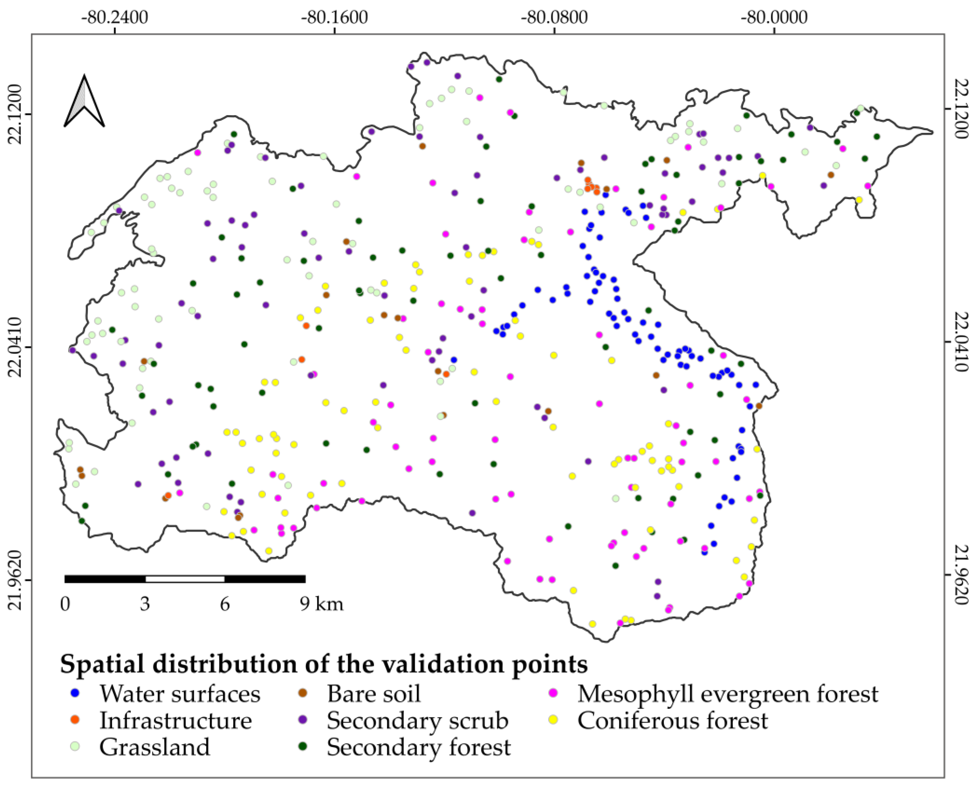
2.6.2. Training Samples (Pure Pixels)
2.6.3. Supervised Classification
2.7. Imagery Accuracy Assessment
2.7.1. Sampling Design
- is the number of units in the area of study (number of overall pixels, because the spatial unit is a pixel);
- is the standard error of the estimated overall accuracy that we would like to achieve;
- is the mapped proportion of area of stratum ;
- is the user’s accuracy estimated for stratum that we would like to achieve;
- is the standard deviation of the stratum i, ;
2.7.2. Response Design
2.7.3. Analysis of Accuracy
3. Results
3.1. Visual Interpretation of Topographic Correction Algorithms
3.2. Statistical Analysis of Spectral Coherence
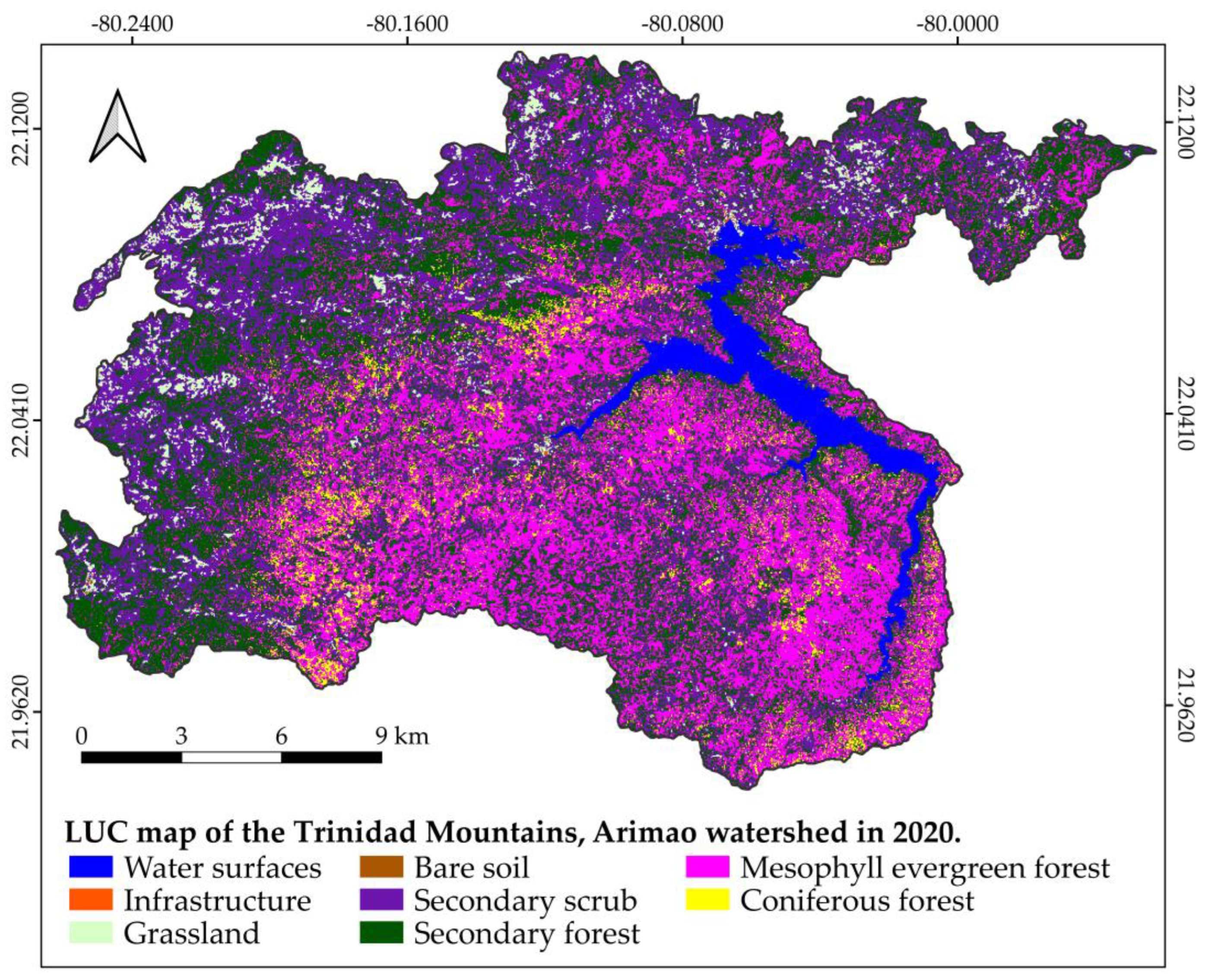
3.3. Accuracy Assessment of Classified Images
4. Discussion
4.1. Spectral Coherence Analysis
4.2. Accuracy Assessment of LUC
5. Conclusions
Supplementary Materials
Author Contributions
Funding
Data Availability Statement
Acknowledgments
Conflicts of Interest
Appendix A
References
- United Nations General Assembly. Transforming Our World: The 2030 Agenda for Sustainable Development; United Nations: New York, NY, USA, 2015; Available online: https://www.refworld.org/legal/resolution/unga/2015/en/111816 (accessed on 22 October 2024).
- Estrategia Ambiental Nacional. Available online: https://www.citma.gob.cu/estrategia-ambiental-nacional/ (accessed on 12 December 2024).
- Borrelli, P.; Robinson, D.A.; Fleischer, L.R.; Lugato, E.; Ballabio, C.; Alewell, C.; Meusburger, K.; Modugno, S.; Schütt, B.; Ferro, V.; et al. An assessment of the global impact of 21st century land use change on soil erosion. Nat. Commun. 2017, 8, 13. [Google Scholar] [CrossRef]
- Schowengerdt, R.A. Remote Sensing: Models and Methods for Image Processing, 3rd ed.; Academic Press: Cambridge, MA, USA, 2007. [Google Scholar]
- Lu, D.; Mausel, P.; Brondízio, E.; Moran, E. Change detection techniques. Int. J. Remote Sens. 2004, 25, 2365–2401. [Google Scholar] [CrossRef]
- Coppin, P.; Nackaerts, K.; Queen, L.; Brewer, K. Operational monitoring of green biomass change for forest management. Photogramm. Eng. Remote Sens. 2001, 67, 603–611. [Google Scholar]
- Estrada, R.; Martín, G.; Martínez, P.; Rodríguez, S.V.; Capote, R.P.; Reyes, I.; Galano, S.; Cabrera, C.; Martínez, C.; Mateo, L.; et al. Mapa (BD-SIG) de vegetación natural y seminatural de Cuba V.1 sobre Landsat ETM 7 SLC-OFF Gap Filled, CIRCA 2011. In Proceedings of the VIII Convención Internacional Sobre Medio Ambiente y Desarrollo, La Habana, Cuba, 4–8 July 2011; p. 15. [Google Scholar]
- Tamarit, I.; Díaz, L.; Ribot, M.; Piedra, F.; Molina, B.; Fernández, D.; Mendes, S.; Toledo, M. Cartografía digital de los ecosistemas costeros para la planificación y gestión de las Areas Protegidas de Cuba. Mapping 2012, 151, 86–95. [Google Scholar]
- Büttner, G.; Steenmans, C.; Bossard, M.; Feranec, J.; Kolár, J. Land Cover—Land Use Mapping within the European Corine Programme. In Remote Sensing for Environmental Data in Albania: A Strategy for Integrated Management; Buchroithner, M.F., Ed.; Springer: Dordrecht, 2000; Volume 72, pp. 89–100. [Google Scholar]
- Li, J.; Roy, D.P. A Global Analysis of Sentinel-2A, Sentinel-2B and Landsat-8 Data Revisit Intervals and Implications for Terrestrial Monitoring. Remote Sens. 2017, 9, 902. [Google Scholar] [CrossRef]
- Pimple, U.; Sitthi, A.; Dario, S.; Sukan, P.; Kumron, L.; Chidthaisong, A. Topographic correction of Landsat TM-5 and Landsat OLI-8 imagery to improve the performance of forest classification in the mountainous terrain of Northeast Thailand. Sustainability 2017, 9, 26. [Google Scholar] [CrossRef]
- Congalton, R.G.; Green, K. Assessing the Accuracy of Remotely Sensed Data: Principles and Practices, 3rd ed.; CRC Press: Boca Raton, FL, USA, 2019; p. 346. [Google Scholar]
- Riaño, D.; Chuvieco, E.; Salas, J.; Aguado, I. Assessment of Different Topographic Corrections in Landsat-TM Data for Mapping Vegetation Types. IEEE Trans. Geosci. Remote Sens. 2003, 41, 1056–1061. [Google Scholar] [CrossRef]
- Chuvieco, E. Fundamentals of Satellite Remote Sensing: An Environmental Approach, 2nd ed.; CRC Press: Boca Raton, FL, USA, 2016; p. 457. [Google Scholar]
- Colby, J.D. Topographic normalization in rugged terrain. Photogramm. Eng. Remote Sens. 1991, 57, 531–537. [Google Scholar]
- Jansa, J. A global topographic normalization algorithm for satellite images. In Proceedings of the Symposium International Society for Photogrammetry and Remote Sensing (ISPRS), Budapest, Hungary, 1–4 September 1998; pp. 8–15. [Google Scholar]
- Leprieur, C.; Durand, J.M.; Peyron, J.L. Influence of topography on forest reflectance using Landsat Thematic Mapper and digital terrain data. Photogramm. Eng. Remote Sens. 1988, 54, 491–496. [Google Scholar]
- Hantson, S.; Chuvieco, E. Evaluation of different topographic correction methods for Landsat imagery. Int. J. Appl. Earth Obs. Geoinf. 2011, 13, 691–700. [Google Scholar] [CrossRef]
- Teillet, P.M.; Guindon, B.; Goodenough, D.G. On the slope-aspect correction of multispectral scanner data. Can. J. Remote Sens. 1982, 8, 84–106. [Google Scholar] [CrossRef]
- Civco, D.L. Topographic Normalization of Landsat Thematic Mapper Digital Imagery. Photogramm. Eng. Remote Sens. 1989, 55, 1303–1309. [Google Scholar]
- Minnaert, M. The reciprocity principle in lunar photometry. Astrophys. J. 1941, 93, 403–410. [Google Scholar] [CrossRef]
- Gupta, S.K.; Shukla, D.P. Evaluation of topographic correction methods for LULC preparation based on multi-source DEMs and Landsat-8 imagery. Spat. Inf. Res. 2019, 28, 113–127. [Google Scholar] [CrossRef]
- Stonestrom, D.A.; Scanlon, B.R.; Zhang, L. Introduction to special section on impacts of land use change on water resources. Water Resour. Res. 2009, 45, 3. [Google Scholar] [CrossRef]
- Wu, Q.; Jin, Y.; Fan, H. Evaluating and comparing performances of topographic correction methods based on multi-source DEMs and Landsat-8 OLI data. Int. J. Remote Sens. 2016, 37, 4712–4730. [Google Scholar] [CrossRef]
- Chance, C.M.; Hermosilla, T.; Coops, N.C.; Wulder, M.A.; White, J.C. Effect of topographic correction on forest change detection using spectral trend analysis of Landsat pixel-based composites. Int. J. Appl. Earth Obs. Geoinf. 2016, 44, 186–194. [Google Scholar] [CrossRef]
- Fan, W.; Li, J.; Liu, Q.; Zhang, Q.; Yin, G.; Li, A.; Zeng, Y.; Xu, B.; Xu, X.; Zhou, G.; et al. Topographic correction of forest image data based on the canopy reflectance model for sloping terrains in multiple forward mode. Remote Sens. 2018, 10, 16. [Google Scholar] [CrossRef]
- Ma, Y.; He, T.; Li, A.; Li, S. Evaluation and Intercomparison of Topographic Correction Methods Based on Landsat Images and Simulated Data. Remote Sens. 2021, 13, 21. [Google Scholar] [CrossRef]
- Adhikari, H.; Heiskanen, J.; Maeda, E.E.; Pellikka, P.K.E. Does topographic normalization of landsat images improve fractional tree cover mapping in tropical mountains? In Proceedings of the 36th International Symposium on Remote Sensing of Environment, Berlin, Germany, 11–15 May 2015; Volume XL-7/W3. pp. 261–267. [Google Scholar] [CrossRef]
- Gao, Y.; Zhang, W. A simple empirical topographic correction method for ETM+ imagery. Int. J. Remote Sens. 2009, 30, 2259–2275. [Google Scholar] [CrossRef]
- Moreira, E.P.; Valeriano, M.M. Application and evaluation of topographic correction methods to improve land cover mapping using object-based classification. Int. J. Appl. Earth Obs. Geoinf. 2014, 32, 208–217. [Google Scholar] [CrossRef]
- Dong, C.; Zhao, G.; Meng, Y.; Li, B.; Peng, B. The Effect of Topographic Correction on Forest Tree Species Classification Accuracy. Remote Sens. 2020, 12, 21. [Google Scholar] [CrossRef]
- Oficina Nacional de Estadística e Información República de Cuba (ONEI). Anuario Estadístico de Cuba 2023; Oficina Nacional de Estadística e Información República de Cuba (ONEI): La Habana, Cuba, 2024; Available online: https://www.onei.gob.cu/anuario-estadistico-de-cuba-2023 (accessed on 25 February 2025).
- Comisión Nacional de Nombres Geográficos (CNNG). Diccionario Geográfico de Cuba; Valdés, J.F., Ed.; Oficina Nacional de Hidrografía y Geodesia: La Habana, Cuba, 2000; p. 387. [Google Scholar]
- Díaz, J.L.; Magaz, A.; Portela, A.; Bouza, O.; Hernández, J. El relieve de Cuba. Ciencias de la Tierra y del Espacio 1990, 18, 33–44. [Google Scholar]
- Instituto de Geología y Paleontología (IGP). Léxico Estratigráfico de Cuba, 3rd ed.; IGP: La Habana, Cuba, 2013. [Google Scholar]
- Viera-González, E.Y.; Fuentes-Roque, L.B.; Gómez-Díaz, D.; Mejías-Seibanes, L.; Sánchez-Santana, T.; Pérez-Rodríguez, Y. Caracterización climática del circuito sur de Cumanayagua, Cienfuegos, Cuba. Rev. UGC 2024, 2, 113–123. [Google Scholar]
- Vasallo, L.; Montes, R.; Escarré-Esteve, A.; León, J.; Bonet, A.; Alomá, O. Consideraciones sobre aspectos ecológicos y estatus de conservación de Pinguicula jackii subsp. jackii (Lentibulariaceae), especie amenazada del centro-sur de Cuba. Acta Bot. Mex. 2019, 126, 14. [Google Scholar] [CrossRef]
- Conrad, O.; Bechtel, B.; Bock, M.; Dietrich, H.; Fischer, E.; Gerlitz, L.; Wehberg, J.; Wichmann, V.; Böhner, J. System for Automated Geoscientific Analyses (SAGA) v. 2.1.4. Geosci. Model Dev. 2015, 8, 1991–2007. [Google Scholar] [CrossRef]
- Ponvert-Delisles, D.R. Leyendas de clases de ocupación del suelo de Cuba. Su empleo en estudios medioambientales que usen imágenes de satélites como datos básicos. In Proceedings of the XV Convención y Feria Internacional Informática 2013, La Habana, Cuba, 18–22 March 2013; p. 15. [Google Scholar]
- Sailer, K. Landsat 8–9. Collection 2 Level 2 Science Product Guide (v6.0); LSDS-1619; U.S. Geological Survey (USGS): Reston, VA, USA, 2022; p. 37. Available online: https://www.usgs.gov/media/files/landsat-8-9-collection-2-level-2-science-product-guide (accessed on 8 October 2024).
- Ghasemi, N.; Mohammadzadeh, A.; Sahebi, M.R. Assessment of different topographic correction methods in ALOS AVNIR-2 data over a forest area. Int. J. Digit. Earth 2013, 6, 504–520. [Google Scholar] [CrossRef]
- Instituto de Geología y Paleontología (IGP). Mapa Geológico Digital de la República de Cuba Escala 1:100 000, 2007.
- Yin, H.; Tan, B.; Frantz, D.; Radeloff, V.C. Integrated topographic corrections improve forest mapping using Landsat imagery. Int. J. Appl. Earth Obs. Geoinf. 2022, 108, 102716. [Google Scholar] [CrossRef]
- Law, K.H.; Nichol, J. Topographic correction for differential illumination effects on ikonos satellite imagery. In Proceedings of the ISPRS Congress, Istanbul, Turkey, 12–23 July 2004; pp. 641–646. [Google Scholar]
- Soenen, S.A.; Peddle, D.R.; Coburn, C.A.; Hall, R.J.; Hall, F.G. Improved topographic correction of forest image data using a 3-D canopy reflectance model in multiple forward mode. Int. J. Remote Sens. 2008, 29, 1007–1027. [Google Scholar] [CrossRef]
- Füreder, P. Topographic correction of satellite images for improved LULC classification in alpine areas. In Proceedings of the 10th International Symposium on High Mountain Remote Sensing Cartography, Kathmandu, Nepal, 8–11 September 2008; pp. 187–194. [Google Scholar]
- Twele, A.; Erasmi, S. Evaluating topographic correction algorithms for improved land cover discrimination in moutainous areas of Central Sulawesi. In Remote Sensing & GIS for Environmental Studies: Applications in Geography; Erasmi, S., Cyffka, B., Kappas, M., Eds.; Göttinger Geographische Abhandlungen: Göttinger, Germany, 2005; Volume 113, pp. 287–295. [Google Scholar]
- Gu, D.; Gillespie, A. Topographic Normalization of Landsat TM Images of Forest Based on Subpixel Sun–Canopy–Sensor Geometry. Remote Sens. Environ. 1998, 64, 166–175. [Google Scholar] [CrossRef]
- Smith, J.A.; Lin, T.L.; Ranson, K. The Lambertian assumption and Landsat data. Photogramm. Eng. Remote Sens. 1980, 46, 1183–1189. [Google Scholar]
- Vanonckelen, S.; Lhermitte, S.; Van Rompaey, A. The effect of atmospheric and topographic correction on pixel-based image composites: Improved forest cover detection in mountain environments. Int. J. Appl. Earth Obs. Geoinf. 2015, 35, 320–328. [Google Scholar] [CrossRef]
- Richter, R.; Kellenberger, T.; Kaufmann, H. Comparison of Topographic Correction Methods. Remote Sens. 2009, 1, 184–196. [Google Scholar] [CrossRef]
- Justice, C.O.; Wharton, S.W.; Holben, B.N. Application of digital terrain data to quantify and reduce the topographic effect on Landsat data. Int. J. Remote Sens. 1981, 2, 213–230. [Google Scholar] [CrossRef]
- Stehman, S.V.; Czaplewski, R.L. Design and Analysis for Thematic Map Accuracy Assessment: Fundamental Principles. Remote Sens. Environ. 1998, 64, 331–344. [Google Scholar] [CrossRef]
- Lloyd, S. Least squares quantization in PCM. IEEE Trans. Inf. Theory 1982, 28, 129–137. [Google Scholar] [CrossRef]
- MacQueen, J. Some methods for classification and analysis of multivariate observations. In Proceedings of the 5th Berkeley Symposium on Mathematical Statistics and Probability, Berkeley, CA, USA, 21 June–18 July 1965; pp. 281–297. [Google Scholar]
- Breiman, L. Random Forests. Mach. Learn. 2001, 45, 5–32. [Google Scholar] [CrossRef]
- Pal, M. Random forest classifier for remote sensing classification. Int. J. Remote Sens. 2005, 26, 217–222. [Google Scholar] [CrossRef]
- Burges, C.J.C. Geometry and invariance in kernel based methods. In Advances in Kernel Methods Support Vector Machines; Schölkopf, B., Burges, C.J.C., Smola, A., Eds.; MIT Press: Cambridge, MA, USA, 1999; pp. 89–116. [Google Scholar]
- Riaño, O.; Acosta, C.D.; Leal, R.O. Clasificación de una imagen satelital empleando máquinas de soporte vectorial para cuantificar el área de Pinus Patula en una plantación. Redes Ing. 2016, 2016:Especial, 54–60. [Google Scholar] [CrossRef]
- Garzón, J.; Sánchez, N.E.; Londoño, D.F. Evaluación comparativa de los algoritmos de aprendizaje automático Support Vector Machine y Random Forest: Efectos del tamaño del conjunto de entrenamiento. Cienc. Ing. Neogranadina 2023, 33, 131–148. [Google Scholar] [CrossRef]
- Tobar-Díaz, R.; Gao, Y.; Francois, J.; Cambrón-Sandoval, V.H. Clasificación de uso y cobertura del suelo a través de algoritmos de aprendizaje automático: Revisión bibliográfica. Rev. Teledetección 2023, 62, 1–19. [Google Scholar] [CrossRef]
- Wacker, A.G.; Landgrebe, D.A. Minimum distance classification in remote sensing. In Proceedings of the Canadian Symposium for Remote Sensing, Ottawa, ON, Canada, 7–9 February 1972; p. 26. Available online: https://ntrs.nasa.gov/api/citations/19730007762/downloads/19730007762.pdf (accessed on 24 September 2024).
- Abinaya, V.; Poonkuntran, S. Classification of Satellite Image using Minimum Distance Classification Algorithm. SSRG Int. J. Comput. Sci. Eng. 2019, 6, 15–18. [Google Scholar]
- Dempster, A.P.; Laird, N.M.; Rubin, D.B. Maximum Likelihood from Incomplete Data Via the EM Algorithm. J. Stat. Soc. Ser. B Methodol. 1976, 39, 1–22. [Google Scholar] [CrossRef]
- Liang, S.; Cheng, J.; Zhang, J. Maximum likelihood classification of soil remote sensing image based on deep learning. Earth Sci. Res. J. 2020, 24, 357–365. [Google Scholar] [CrossRef]
- Kruse, F.A.; Lefkoff, A.B.; Boardman, J.W.; Heidebrecht, K.B.; Shapiro, A.T.; Barloon, P.J.; Goetz, A.F.H. The spectral image processing system (SIPS)-interactive visualization and analysis of imaging spectrometer data. Remote Sens. Environ. 1993, 44, 145–163. [Google Scholar] [CrossRef]
- Girouard, G.G.; Bannari, A.; El Harti, A.; Desrochers, A. Validated Spectral Angle Mapper Algorithm for Geological Mapping: Comparative Study between Quickbird and Landsat-TM. In Proceedings of the International Archives of the Photogrammetry, Remote Sensing and Spatial Information Sciences, Beijing, China, 3–11 July 2004; pp. 1–6. [Google Scholar]
- Congedo, L. Semi-Automatic Classification Plugin Documentation (v7.8.0.1). 2020. Available online: https://enauczanie.pg.edu.pl/moodle/pluginfile.php/1290421/mod_resource/content/1/semiautomaticclassificationmanual.pdf (accessed on 19 July 2024).
- Mas, J.-F.; Pérez-Vega, A.; Ghilardi, A.; Martínez, S.; Loya-Carrillo, J.O.; Vega, E. A Suite of Tools for Assessing Thematic Map Accuracy. Geogr. J. 2014, 2014, 1–10. [Google Scholar] [CrossRef]
- Olofsson, P.; Foody, G.M.; Stehman, S.V.; Woodcock, C.E. Making better use of accuracy data in land change studies: Estimating accuracy and area and quantifying uncertainty using stratified estimation. Remote Sens. Environ. 2013, 129, 122–131. [Google Scholar] [CrossRef]
- Olofsson, P.; Foody, G.M.; Herold, M.; Stehman, S.V.; Woodcock, C.E.; Wulder, M.A. Good practices for estimating area and assessing accuracy of land change. Remote Sens. Environ. 2014, 148, 42–57. [Google Scholar] [CrossRef]
- Congalton, R.G.; Green, K. Assessing the Accuracy of Remotely Sensed Data: Principles and Practices, 2nd ed.; CRC Press: Boca Raton, FL, USA, 2009. [Google Scholar]
- Strahler, A.S.; Boschetti, L.; Foody, G.M.; Friedl, M.A.; Morisette, J.T.; Stehman, S.V.; Woodcock, C.E. Global Land Cover Validation: Recommendations for Evaluations and Accuracy Assessment of Global Land Cover Maps; Office for Official Publications of the European Communities: Luxembourg, 2006; Available online: https://gofcgold.umd.edu/sites/default/files/docs/ReportSeries/GOLD_25.pdf (accessed on 18 September 2024).
- Pontius, R.G.; Millones, M. Death to Kappa: Birth of quantity disagreement and allocation disagreement for accuracy assessment. Int. J. Remote Sens. 2011, 32, 4407–4429. [Google Scholar] [CrossRef]
- Foody, G.M. Explaining the unsuitability of the kappa coefficient in the assessment and comparison of the accuracy of thematic maps obtained by image classification. Remote Sens. Environ. 2020, 239, 111630. [Google Scholar] [CrossRef]
- Finegold, Y.; Ortmann, A.; Lindquist, E.; d’Annunzio, R.; Sandker, M. Map Accuracy Assessment and Area Estimation. A Practical Guide; Food and Agriculture Organization of the United Nations (FAO): Rome, Italy, 2016; p. 60. Available online: https://openknowledge.fao.org/handle/20.500.14283/i5601e (accessed on 24 March 2024).
- Castillo-Santiago, M.Á.; Mondragón-Vázquez, E.; Domínguez-Vera, R. Sample Data for Thematic Accuracy Assessment in QGIS. In Land Use Cover Datasets and Validation Tools: Validation Practices with QGIS; García-Álvarez, D., Camacho Olmedo, M.T., Paegelow, M., Mas, J.F., Eds.; Springer International Publishing: Cham, Switzerland, 2022; pp. 85–96. [Google Scholar]
- Congalton, R.G. A Comparison of Sampling Schemes Used in Generating Error Matrices for Assessing the Accuracy of Maps Generated from Remotely Sensed Data. Photogramm. Eng. Remote Sens. 1988, 54, 593–600. [Google Scholar]
- Valero-Jorge, A.; González-De Zayas, R.; Matos-Pupo, F.; Becerra-González, A.L.; Álvarez-Taboada, F. Mapping and Monitoring of the Invasive Species Dichrostachys Cinerea (Marabú) in Central Cuba Using Landsat Imagery and Machine Learning (1994–2022). Remote Sens. 2024, 16, 20. [Google Scholar] [CrossRef]
- Llano, X. SMByC-IDEAM AcATaMa—QGIS Plugin for Accuracy Assessment of Thematic Map, 23.4. 2023. Available online: https://github.com/SMByC/AcATaMa (accessed on 15 September 2024).
- Milhomem Ferreira, D. Mudanças de Uso e Cobertura da Terra na Bacia do Rio Lajeado, Estado do Maranhão. Master Thesis, Universidade Estadual do Maranhão, Balsas, Brasil, 23 June 2020. [Google Scholar]
- Mota, A.; Curcino, N.; Gioppo, F.; Andrade, L.; Assunção, C.F. Digital Image Classification: A Comparison of Classic Methods for Land Cover and Land Use Mapping. Anu. Inst. Geociênc. 2022, 45, 1–10. [Google Scholar] [CrossRef]
- Sabino, R. Aplicação da deteção remota na monitorização de espécies exóticas invasoras em ambientes aquáticos. Master Thesis, Universidade d Coimbra, Beira Litoral, Portugal, 13 July 2023. [Google Scholar]
- Melo da Silva, J.G.; Quintanilha, J.A.; Grohmann, C.H.; Ribeiro da Costa, D.; Monteiro da Costa, J.D.; Antana da Silva, J.M. Distribuição da Biomassa vegetal e sequestro de carbono na sub-bacia do Rio Pirajibu no município de Sorocaba/SP. Rev. Bras. Geogr. Física 2023, 16, 1647–1656. [Google Scholar] [CrossRef]
- Gao, M.-L.; Zhao, W.-J.; Gong, Z.-N.; Gong, H.-L.; Chen, Z.; Tang, X.-M. Topographic correction of ZY-3 satellite images and its effects on estimation of shrub leaf biomass in mountainous areas. Remote Sens. 2014, 6, 2745–2764. [Google Scholar] [CrossRef]
- Soenen, S.A.; Peddle, D.R.; Coburn, C.A. SCS+C: A modified Sun-canopy-sensor topographic correction in forested terrain. IEEE Trans. Geosci. Remote Sens. 2005, 43, 2148–2159. [Google Scholar] [CrossRef]
- Umarhadi, D.A.; Danoedoro, P. Correcting topographic effect on Landsat-8 images: An evaluation of using different DEMs in Indonesia. In Proceedings of the 6th Geoinformation Science Symposium, Yogyakarta, Indonesia, 26–27 August 2019; p. 7. [Google Scholar] [CrossRef]
- Camargo, C.E.; Pacheco, C.E.; López, R. Evaluación de métodos de corrección atmosférica y sombreado topográfico en imagen Landsat 8 OLI sobre un área montañosa semiárida. UD Geomática 2021, 16, 23–39. [Google Scholar] [CrossRef]
- Zylshal, Z. Performance evaluation of different DEMs for topographic correction on LAPAN-A3: Preliminary results. In Proceedings of the 6th Geoinformation Science Symposium, Yogyakarta, Indonesia, 26–27 August 2019; p. 9. [Google Scholar] [CrossRef]

| Correction Algorithms | Equation | Reference | |
|---|---|---|---|
| Cosine | (2) | [19] | |
| Improved Cosine | (3) | [20] | |
| C Correction * | (4) | [19] | |
| Minnaert | (5) | [21] | |
| Minnaert of Riano ** | (6) | [13] | |
| Minnaert of Law *** | (7) | [44] | |
| Normalization | (8) | [44] |
| Methods/Stratum | WS | IS | GL | BS | SS | SF | EF | CF | Total Samples |
|---|---|---|---|---|---|---|---|---|---|
| Alloc1 (equal) | 59 | 59 | 59 | 59 | 59 | 59 | 59 | 59 | 475 |
| Alloc2 (proportional) | 18 | 0.04 | 16 | 0.5 | 108 | 174 | 143 | 16 | 475 |
| Alloc3 (1 rare stratum) | 17 | 20 | 15 | 0 | 104 | 166 | 137 | 15 | 475 |
| Alloc4 (2 rare stratums) | 74 | 10 | 74 | 20 | 74 | 74 | 74 | 75 * | 475 |
| Algorithm | Statistic | Band2 Blue | Band3 Green | Band4 Red | Band5 NIR | Band6 SWIR1 | Band7 SWIR2 | Total Change |
|---|---|---|---|---|---|---|---|---|
| Cosine | µ | −0.284 | −0.765 | −0.431 | −7.312 | −2.941 | −1.202 | −12.935 |
| σ | −5.122 | −20.001 | −9.005 | −222.945 | −64.193 | −24.897 | −346.163 | |
| −329.30 | −506.07 | −388.40 | −588.66 | −399.36 | −374.87 | −2586.66 | ||
| Improved Cosine | µ | −0.001 | −0.004 | 0.005 | −0.003 | 0.052 | 0.024 | 0.074 |
| σ | −0.042 | −0.113 | −0.042 | −0.705 | −0.206 | −0.074 | −1.181 | |
| −3.398 | −3.552 | −2.412 | −2.336 | −1.773 | −1.627 | −15.100 | ||
| C-correction | µ | −0.330 | −0.857 | −0.490 | −8.232 | −3.355 | −1.369 | −14.633 |
| σ | −8.014 | −20.416 | −11.374 | −221.94 | −84.708 | −32.174 | −378.63 | |
| −503.49 | −503.96 | −479.15 | −571.10 | −514.82 | −473.59 | −3046.1 | ||
| Minnaert k = 0.2 | µ | −0.033 | −0.086 | −0.049 | −0.823 | −0.337 | −0.138 | −1.467 |
| σ | −0.003 | 0.008 | −0.008 | 0.199 | 0.060 | 0.008 | 0.264 | |
| 0.941 | 1.187 | 0.963 | 1.578 | 1.487 | 1.334 | 7.489 | ||
| Minnaert k = 0.3 | µ | −0.053 | −0.137 | −0.078 | −1.312 | −0.537 | −0.220 | −2.337 |
| σ | −0.014 | −0.019 | −0.027 | 0.023 | −0.013 | −0.027 | −0.078 | |
| 0.684 | 0.912 | 0.766 | 1.538 | 1.520 | 1.366 | 6.785 | ||
| Min-Riano k = 0.2 | µ | 0.020 | 0.055 | 0.034 | 0.548 | 0.242 | 0.100 | 0.997 |
| σ | 0.018 | 0.060 | 0.038 | 0.641 | 0.272 | 0.108 | 1.136 | |
| 0.718 | 1.304 | 1.120 | 1.517 | 1.389 | 1.178 | 7.226 | ||
| Min-Riano k = 0.3 | µ | −0.004 | −0.010 | −0.003 | −0.070 | −0.013 | −0.005 | −0.105 |
| σ | 0.007 | 0.038 | 0.019 | 0.508 | 0.209 | 0.074 | 0.855 | |
| 0.748 | 1.315 | 1.142 | 1.762 | 1.668 | 1.441 | 8.076 | ||
| Min-Riano k = 0.4 | µ | −0.032 | −0.081 | −0.044 | −0.755 | −0.296 | −0.121 | −1.330 |
| σ | −0.015 | −0.020 | −0.017 | 0.030 | 0.021 | −0.006 | −0.007 | |
| −0.093 | 0.274 | 0.353 | 0.955 | 1.072 | 0.932 | 3.493 | ||
| Min-Law k = 0.2 | µ | −0.091 | −0.227 | −0.130 | −2.156 | −0.910 | −0.375 | −3.889 |
| σ | −0.030 | −0.037 | −0.047 | −0.270 | −0.177 | −0.109 | −0.670 | |
| 0.714 | 1.293 | 1.119 | 1.509 | 1.381 | 1.172 | 7.187 | ||
| Min-Law k = 0.3 | µ | −0.178 | −0.450 | −0.260 | −4.304 | −1.815 | −0.747 | −7.755 |
| σ | −0.067 | −0.113 | −0.113 | −0.909 | −0.490 | −0.263 | −1.955 | |
| 0.741 | 1.302 | 1.134 | 1.749 | 1.657 | 1.430 | 8.012 | ||
| Min-Law k = 0.4 | µ | −0.274 | −0.696 | −0.402 | −6.660 | −2.807 | −1.156 | −11.99 |
| σ | −0.121 | −0.237 | −0.204 | −1.994 | −0.968 | −0.480 | −4.004 | |
| −0.104 | 0.258 | 0.340 | 0.938 | 1.057 | 0.920 | 3.409 | ||
| Normalization | µ | −0.001 | −0.004 | 0.005 | −0.003 | 0.052 | 0.024 | 0.074 |
| σ | −0.042 | −0.113 | −0.042 | −0.705 | −0.206 | −0.074 | −1.181 | |
| −3.398 | −3.552 | −2.412 | −2.336 | −1.773 | −1.627 | −15.100 |
| LUC Classes | Original Image | Minnaert (k = 0.2) | ||||
|---|---|---|---|---|---|---|
| UA | PA | OA | UA | PA | OA | |
| Water surface | 100.00 | 68.06 | 89.47 | 97.37 | 100.00 | 92.10 |
| Infrastructure | 100.00 | 100.00 | 100.00 | 100.00 | ||
| Grassland | 96.00 | 99.86 | 100.00 | 91.67 | ||
| Bare soil | 90.00 | 64.15 | 100.00 | 67.26 | ||
| Secondary scrub | 93.42 | 93.45 | 93.42 | 97.91 | ||
| Secondary forest | 85.90 | 91.39 | 90.00 | 95.19 | ||
| Mesophyll evergreen forest | 89.19 | 92.70 | 92.00 | 94.82 | ||
| Coniferous forest | 85.92 | 57.42 | 95.45 | 45.85 | ||
| LUC Classes | Min-Riano (k = 0.2) | Min-Riano (k = 0.3) | ||||
| UA | PA | OA | UA | PA | OA | |
| Water surface | 97.37 | 100.00 | 91.58 | 100.00 | 90.02 | 94.08 |
| Infrastructure | 100.00 | 100.00 | 100.00 | 100.00 | ||
| Grassland | 100.00 | 91.40 | 98.65 | 100.00 | ||
| Bare soil | 89.47 | 64.76 | 95.00 | 100.00 | ||
| Secondary scrub | 93.42 | 97.91 | 98.61 | 92.27 | ||
| Secondary forest | 88.75 | 95.13 | 92.41 | 95.25 | ||
| Mesophyll evergreen forest | 92.00 | 94.66 | 92.00 | 97.59 | ||
| Coniferous forest | 93.94 | 42.69 | 88.73 | 69.75 | ||
| LUC Classes | Original Image | Minnaert (k = 0.2) | ||||
|---|---|---|---|---|---|---|
| Adjusted Area | Standard Error | % of Total Area | Adjusted Area | Standard Error | % of Total Area | |
| Water surfaces | 22.68 (±7.05) | 3.60 | 5.50 | 14.89 (±0.55) | 0.28 | 3.61 |
| Infrastructure | 0.036 (±0.0) | 0.00 | 0.009 | 0.036 (±0.0) | 0.00 | 0.009 |
| Grassland | 13.01 (±0.60) | 0.31 | 3.16 | 14.85 (±2.43) | 1.24 | 3.60 |
| Bare soil | 0.50 (±0.36) | 0.18 | 0.12 | 0.61 (±0.39) | 0.20 | 0.15 |
| Secondary scrub | 94.07 (±8.37) | 4.27 | 22.81 | 89.73 (±6.43) | 3.28 | 21.77 |
| Secondary forest | 141.77 (±14.06) | 7.17 | 34.37 | 141.97 (±11.49) | 5.86 | 34.42 |
| Mesophyll evergreen forest | 119.48 (±11.58) | 5.91 | 28.97 | 120.85 (±9.97) | 5.09 | 29.33 |
| Coniferous forest | 20.91 (±7.82) | 3.99 | 5.07 | 29.52 (±10.13) | 5.17 | 7.16 |
| LUC Classes | Minnaert-R (k = 0.2) | Minnaert-R (k = 0.3) | ||||
| Adjusted Area | Standard Error | % of Total Area | Adjusted Area | Standard Error | % of Total Area | |
| Water surfaces | 14.95 (±0.55) | 0.28 | 3.62 | 16.92 (±3.28) | 1.67 | 4.10 |
| Infrastructure | 0.036 (±0.0) | 0.00 | 0.009 | 0.037 (±0.0) | 0.00 | 0.01 |
| Grassland | 14.89 (±2.43) | 1.24 | 3.61 | 13.83 (±0.37) | 0.19 | 3.35 |
| Bare soil | 0.57 (±0.40) | 0.20 | 0.14 | 0.39 (±0.04) | 0.02 | 0.09 |
| Secondary scrub | 89.73 (±6.43) | 3.28 | 21.77 | 100.50 (±7.73) | 3.94 | 24.37 |
| Secondary forest | 140.12 (±11.95) | 6.10 | 33.97 | 145.25 (±10.76) | 5.49 | 35.21 |
| Mesophyll evergreen forest | 121.07 (±9.98) | 5.09 | 29.38 | 118.21 (±8.63) | 4.40 | 28.66 |
| Coniferous forest | 31.10 (±10.72) | 5.47 | 7.54 | 17.32 (±6.00) | 3.06 | 4.20 |
Disclaimer/Publisher’s Note: The statements, opinions and data contained in all publications are solely those of the individual author(s) and contributor(s) and not of MDPI and/or the editor(s). MDPI and/or the editor(s) disclaim responsibility for any injury to people or property resulting from any ideas, methods, instructions or products referred to in the content. |
© 2025 by the authors. Licensee MDPI, Basel, Switzerland. This article is an open access article distributed under the terms and conditions of the Creative Commons Attribution (CC BY) license (https://creativecommons.org/licenses/by/4.0/).
Share and Cite
Sánchez-Llull, M.; Castellanos Torres, L.; Muñoz Caravaca, A.; Martín Morales, G.; Sauvage, S.; Zulueta-Véliz, Y.; Olalde Chang, E.J.; León Cabrera, J.; Vasallo-Rodríguez, L.; Ouillon, S.; et al. Assessing Classification Accuracy as a Criterion for Evaluating the Performance of Seven Topographic Correction Algorithms in the Trinidad Mountains, Cuba. Remote Sens. 2025, 17, 1032. https://doi.org/10.3390/rs17061032
Sánchez-Llull M, Castellanos Torres L, Muñoz Caravaca A, Martín Morales G, Sauvage S, Zulueta-Véliz Y, Olalde Chang EJ, León Cabrera J, Vasallo-Rodríguez L, Ouillon S, et al. Assessing Classification Accuracy as a Criterion for Evaluating the Performance of Seven Topographic Correction Algorithms in the Trinidad Mountains, Cuba. Remote Sensing. 2025; 17(6):1032. https://doi.org/10.3390/rs17061032
Chicago/Turabian StyleSánchez-Llull, Minerva, Laura Castellanos Torres, Alain Muñoz Caravaca, Gustavo Martín Morales, Sabine Sauvage, Yeleny Zulueta-Véliz, Eugenio Jesús Olalde Chang, Julio León Cabrera, Leosveli Vasallo-Rodríguez, Sylvain Ouillon, and et al. 2025. "Assessing Classification Accuracy as a Criterion for Evaluating the Performance of Seven Topographic Correction Algorithms in the Trinidad Mountains, Cuba" Remote Sensing 17, no. 6: 1032. https://doi.org/10.3390/rs17061032
APA StyleSánchez-Llull, M., Castellanos Torres, L., Muñoz Caravaca, A., Martín Morales, G., Sauvage, S., Zulueta-Véliz, Y., Olalde Chang, E. J., León Cabrera, J., Vasallo-Rodríguez, L., Ouillon, S., & Sánchez-Pérez, J.-M. (2025). Assessing Classification Accuracy as a Criterion for Evaluating the Performance of Seven Topographic Correction Algorithms in the Trinidad Mountains, Cuba. Remote Sensing, 17(6), 1032. https://doi.org/10.3390/rs17061032