
Mapping Harmful Algae Blooms: The Potential of Hyperspectral Imaging Technologies


Abstract
1. Introduction
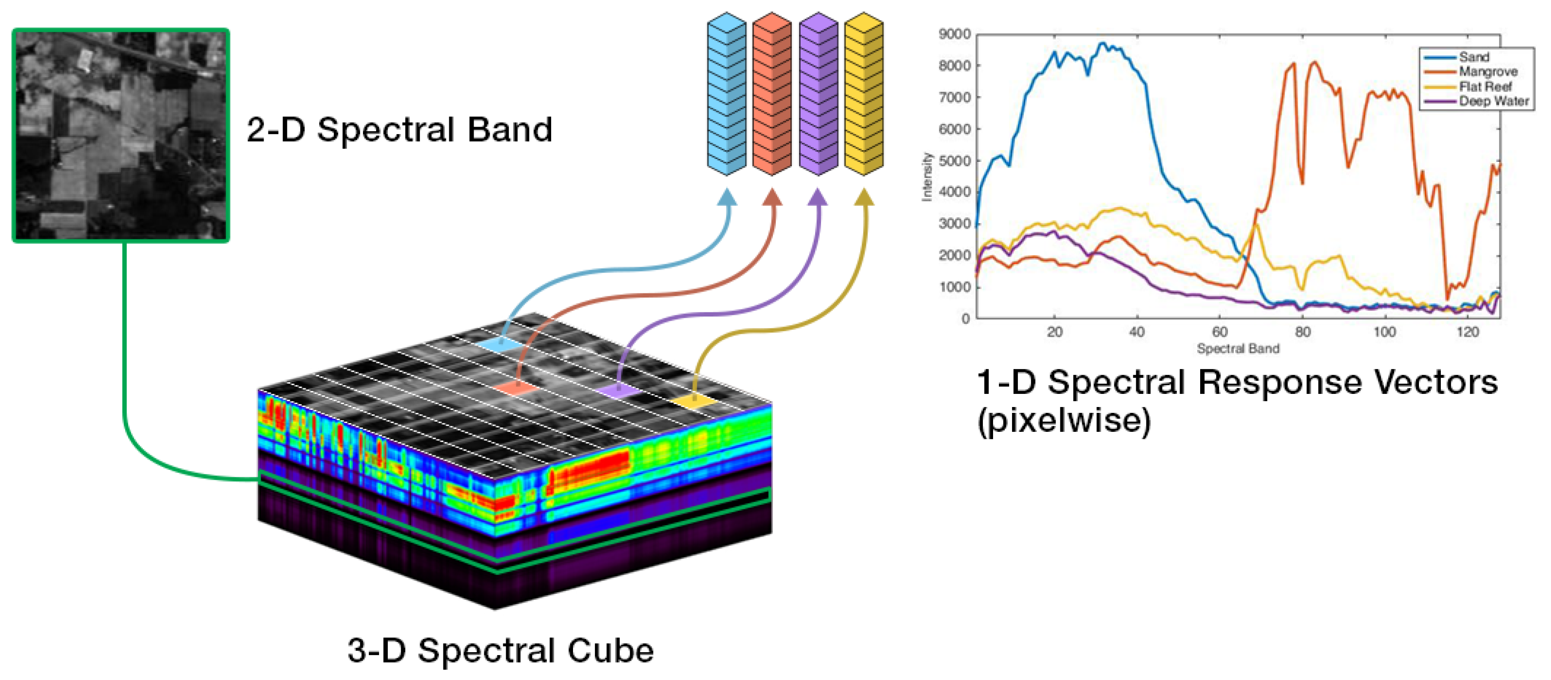
2. Hyperspectral Imaging Fundamentals
3. Sensing Platforms and Data Acquisition
3.1. Satellites
3.2. Manned Aircraft
3.3. Unmanned Aerial Vehicles (UAVs)
3.4. Handheld Devices
4. Data Analysis Techniques and Innovations
4.1. Model-Based vs. Learning-Based Approaches
4.1.1. Model-Based Approaches
4.1.2. Learning-Based Approaches
5. Current Challenges in HSI Implementation
6. Future Directions and Emerging Technologies
7. Policy and Economic Implications
8. Conclusions
- HSI-based HAB detection frequently achieves 70–90% accuracy (or R22 values > 0.7) in moderate conditions, with complex or hybrid algorithms needed for extreme cases of algal concentration or highly mixed species.
- Satellite sensors remain the most popular due to wide coverage and open-access data, yet their spectral limitations and revisit constraints can hamper real-time detection of transient events.
- UAVs and handheld devices excel at fine-scale analysis, but their narrower coverage and logistical requirements restrict broader operational use.
- Both model-based (e.g., spectral indices) and learning-based approaches (e.g., convolutional neural networks) demonstrate substantial potential for HAB monitoring applications, with each showing different sensitivities to data volume and environmental complexity.
- Improved synergy between UAV, satellite, and lab-based HSI data can yield significantly improved cross-scale detection.
- More robust machine learning algorithms need to address domain adaptation, data scarcity, and edge-deployment efficiency for real-time HAB alerts.
- Innovations in hardware miniaturization and cost reduction remain vital for expanding HSI to resource-limited regions.
- Standardization of measurement protocols, data calibration, and reporting formats is critical for consistent inter-study comparison.
Author Contributions
Funding
Data Availability Statement
Acknowledgments
Conflicts of Interest
References
- Shahmohamadloo, R.S.; Frenken, T.; Rudman, S.M.; Ibelings, B.W.; Trainer, V.L. Diseases and disorders in fish due to harmful algal blooms. In Climate Change on Diseases and Disorders of Finfish in Cage Culture; CABI: Wallingford, UK, 2023; pp. 387–429. [Google Scholar]
- Carias, J.; Vásquez-Lavín, F.; Barrientos, M.; Oliva, R.D.P.; Gelcich, S. Economic valuation of Harmful Algal Blooms (HAB): Methodological challenges, policy implications, and an empirical application. J. Environ. Manag. 2024, 365, 121566. [Google Scholar] [CrossRef] [PubMed]
- Alvarez, S.; Brown, C.E.; Diaz, M.G.; O’Leary, H.; Solís, D. Non-linear impacts of harmful algae blooms on the coastal tourism economy. J. Environ. Manag. 2024, 351, 119811. [Google Scholar] [CrossRef]
- Abbas, M.; Dia, S.; Deutsch, E.S.; Alameddine, I. Analyzing eutrophication and harmful algal bloom dynamics in a deep Mediterranean hypereutrophic reservoir. Environ. Sci. Pollut. Res. 2023, 30, 37607–37621. [Google Scholar] [CrossRef]
- Summers, E.J.; Ryder, J.L. A critical review of operational strategies for the management of harmful algal blooms (HABs) in inland reservoirs. J. Environ. Manag. 2023, 330, 117141. [Google Scholar] [CrossRef]
- Devlin, M.; Brodie, J. Nutrients and eutrophication. In Marine Pollution–Monitoring, Management and Mitigation; Springer: Berlin/Heidelberg, Germany, 2023; pp. 75–100. [Google Scholar]
- Hu, Z.; Li, A.; Li, Z.; Mulholland, M.R. The impacts of anthropogenic activity and climate change on the formation of harmful algal blooms (HABs) and its ecological consequence. Front. Mar. Sci. 2024, 11, 1397744. [Google Scholar] [CrossRef]
- Rogers, M.M.; Stanley, R.K. Airborne algae: A rising public health risk. Environ. Sci. Technol. 2023, 57, 5501–5503. [Google Scholar] [CrossRef] [PubMed]
- Mollerup, I.M.; Bjørneset, J.; Krock, B.; Jensen, T.H.; Galatius, A.; Dietz, R.; Teilmann, J.; van den Brand, J.M.; Osterhaus, A.; Kokotovic, B.; et al. Did algal toxin and Klebsiella infections cause the unexplained 2007 mass mortality event in Danish and Swedish marine mammals? Sci. Total Environ. 2024, 914, 169817. [Google Scholar] [CrossRef] [PubMed]
- Tornabene, B.J.; Smalling, K.L.; Hossack, B.R. Effects of Harmful Algal Blooms on Amphibians and Reptiles are Under-Reported and Under-Represented. Environ. Toxicol. Chem. 2024, 43, 1936–1949. [Google Scholar] [CrossRef] [PubMed]
- Gernez, P.; Zoffoli, M.L.; Lacour, T.; Fariñas, T.H.; Navarro, G.; Caballero, I.; Harmel, T. The many shades of red tides: Sentinel-2 optical types of highly-concentrated harmful algal blooms. Remote Sens. Environ. 2023, 287, 113486. [Google Scholar] [CrossRef]
- Cazzaniga, I.; Zibordi, G.; Mélin, F. Spectral features of ocean colour radiometric products in the presence of cyanobacteria blooms in the Baltic Sea. Remote Sens. Environ. 2023, 287, 113464. [Google Scholar] [CrossRef]
- Wu, W.; Zhai, F.; Gu, Y.; Liu, C.; Li, P. Weak local upwelling may elevate the risks of harmful algal blooms and hypoxia in shallow waters during the warm season. Environ. Res. Lett. 2023, 18, 114031. [Google Scholar] [CrossRef]
- Chen, J.; Glibert, P.M.; Cai, W.J.; Huang, D. Eutrophication, algal bloom, hypoxia and ocean acidification in large river estuaries, volume II. Front. Mar. Sci. 2023, 10, 1225903. [Google Scholar] [CrossRef]
- Nugumanova, G.; Ponomarev, E.D.; Askarova, S.; Fasler-Kan, E.; Barteneva, N.S. Freshwater cyanobacterial toxins, cyanopeptides and neurodegenerative diseases. Toxins 2023, 15, 233. [Google Scholar] [CrossRef]
- Belshiasheeela, I.; Ghosh, M. The role of zooplankton in the growth of algal bloom: A mathematical study. Stoch. Anal. Appl. 2024, 42, 591–621. [Google Scholar] [CrossRef]
- Gaul, L. The Impact of Light Intensity on the Growth of Algal Cells and Proposed Control Methods for Harmful Algal Blooms. Chemosphere 2023, 309, 136611. [Google Scholar]
- Hendrawan, D.I.; Rinanti, A.; Fachrul, M.F.; Tazkiaturrizki; Minarti, A.; Marendra, S.M.P.; Zahra, L.A. Addressing Algal Bloom and Other Ecological Issues Caused by Microalgae Biomass Conversion Technology. In Algae as a Natural Solution for Challenges in Water-Food-Energy Nexus: Toward Carbon Neutrality; Springer: Berlin/Heidelberg, Germany, 2024; pp. 373–431. [Google Scholar]
- Zhang, Y.; Whalen, J.K.; Cai, C.; Shan, K.; Zhou, H. Harmful cyanobacteria-diatom/dinoflagellate blooms and their cyanotoxins in freshwaters: A nonnegligible chronic health and ecological hazard. Water Res. 2023, 233, 119807. [Google Scholar] [CrossRef]
- Chen, Y.; Xue, J.; Feng, W.; Du, J.; Wu, H. Bloom forming species transported by ballast water under the management of D-1 and D-2 standards—Implications for current ballast water regulations. Mar. Pollut. Bull. 2023, 194, 115391. [Google Scholar] [CrossRef]
- Oduor, N.A.; Munga, C.N.; Ong’anda, H.O.; Botwe, P.K.; Moosdorf, N. Nutrients and harmful algal blooms in Kenya’s coastal and marine waters: A review. Ocean. Coast. Manag. 2023, 233, 106454. [Google Scholar] [CrossRef]
- Duan, Z.; Gao, W.; Cheng, G.; Zhang, Y.; Chang, X. Warming surface and Lake heatwaves as key drivers to harmful algal Blooms: A case study of Lake Dianchi, China. J. Hydrol. 2024, 632, 130971. [Google Scholar] [CrossRef]
- Díaz, P.A.; Figueroa, R.I. Toxic algal bloom recurrence in the era of global change: Lessons from the Chilean Patagonian fjords. Microorganisms 2023, 11, 1874. [Google Scholar] [CrossRef]
- Chatterjee, S.; More, M. Cyanobacterial harmful algal bloom toxin microcystin and increased vibrio occurrence as climate-change-induced biological co-stressors: Exposure and disease outcomes via their interaction with gut–liver–brain axis. Toxins 2023, 15, 289. [Google Scholar] [CrossRef]
- Li, X.Y.; Yu, R.C.; Richardson, A.J.; Sun, C.; Eriksen, R.; Kong, F.Z.; Zhou, Z.X.; Geng, H.X.; Zhang, Q.C.; Zhou, M.J. Marked shifts of harmful algal blooms in the Bohai Sea linked with combined impacts of environmental changes. Harmful Algae 2023, 121, 102370. [Google Scholar] [CrossRef]
- Paerl, H.W. Climate change, phytoplankton, and HABs. In Climate Change and Estuaries; CRC Press: Boca Raton, FL, USA, 2023; pp. 315–334. [Google Scholar]
- Lim, C.C.; Yoon, J.; Reynolds, K.; Gerald, L.B.; Ault, A.P.; Heo, S.; Bell, M.L. Harmful algal bloom aerosols and human health. EBioMedicine 2023, 93, 104604. [Google Scholar] [CrossRef]
- French, B.W.; Kaul, R.; George, J.; Haller, S.T.; Kennedy, D.J.; Mukundan, D. A Case Series of Potential Pediatric Cyanotoxin Exposures Associated with Harmful Algal Blooms in Northwest Ohio. Infect. Dis. Rep. 2023, 15, 726–734. [Google Scholar] [CrossRef]
- Tan, K.; Sun, Y.; Zhang, H.; Zheng, H. Effects of harmful algal blooms on the physiological, immunity and resistance to environmental stress of bivalves: Special focus on paralytic shellfish poisoning and diarrhetic shellfish poisoning. Aquaculture 2023, 563, 739000. [Google Scholar] [CrossRef]
- Hoagland, P.; Scatasta, S. The economic effects of harmful algal blooms. In Ecology of Harmful Algae; Springer: Berlin/Heidelberg, Germany, 2006; pp. 391–402. [Google Scholar]
- Pierce, R.H.; Henry, M.S. Harmful algal toxins of the Florida red tide (Karenia brevis): Natural chemical stressors in South Florida coastal ecosystems. Ecotoxicology 2008, 17, 623–631. [Google Scholar] [CrossRef]
- Fleming, L.E.; Kirkpatrick, B.; Backer, L.C.; Walsh, C.J.; Nierenberg, K.; Clark, J.; Reich, A.; Hollenbeck, J.; Benson, J.; Cheng, Y.S.; et al. Review of Florida red tide and human health effects. Harmful Algae 2011, 10, 224–233. [Google Scholar] [CrossRef]
- Kirkpatrick, B.; Bean, J.A.; Fleming, L.E.; Kirkpatrick, G.; Grief, L.; Nierenberg, K.; Reich, A.; Watkins, S.; Naar, J. Gastrointestinal emergency room admissions and Florida red tide blooms. Harmful Algae 2010, 9, 82–86. [Google Scholar] [CrossRef] [PubMed]
- Hoagland, P.; Jin, D.; Polansky, L.Y.; Kirkpatrick, B.; Kirkpatrick, G.; Fleming, L.E.; Reich, A.; Watkins, S.M.; Ullmann, S.G.; Backer, L.C. The costs of respiratory illnesses arising from Florida Gulf Coast Karenia brevis blooms. Environ. Health Perspect. 2009, 117, 1239–1243. [Google Scholar] [CrossRef]
- Moeltner, K.; Fanara, T.; Foroutan, H.; Hanlon, R.; Lovko, V.; Ross, S.; Schmale, D., III. Harmful algal blooms and toxic air: The economic value of improved forecasts. Mar. Resour. Econ. 2023, 38, 1–28. [Google Scholar] [CrossRef]
- Ofori, R.O. Willingness to Contribute Time versus Willingness to Pay for the Management of Harmful Algal Blooms. Phycology 2023, 3, 382–393. [Google Scholar] [CrossRef]
- Peng, Y.; Zhang, W.; Yang, X.; Zhang, Z.; Zhu, G.; Zhou, S. Current status and prospects of algal bloom early warning technologies: A Review. J. Environ. Manag. 2024, 349, 119510. [Google Scholar]
- Sagarminaga, Y.; Garcés, E.; Francé, J.; Stern, R.; Revilla, M.; Magaletti, E.; Bresnan, E.; Tsirtsis, G.; Jakobsen, H.H.; Sampedro, N.; et al. New tools and recommendations for a better management of harmful algal blooms under the European Marine Strategy Framework Directive. Front. Ocean. Sustain. 2023, 1, 1298800. [Google Scholar] [CrossRef]
- Caballero, I.; Fernández, R.; Escalante, O.M.; Mamán, L.; Navarro, G. New capabilities of Sentinel-2A/B satellites combined with in situ data for monitoring small harmful algal blooms in complex coastal waters. Sci. Rep. 2020, 10, 8743. [Google Scholar] [CrossRef]
- Morón-López, J.; Rodríguez-Sánchez, M.C.; Carreño, F.; Vaquero, J.; Pompa-Pernía, Á.G.; Mateos-Fernández, M.; Aguilar, J.A.P. Implementation of smart buoys and satellite-based systems for the remote monitoring of harmful algae bloom in inland waters. IEEE Sensors J. 2020, 21, 6990–6997. [Google Scholar] [CrossRef]
- Jain, M. The benefits and pitfalls of using satellite data for causal inference. Rev. Environ. Econ. Policy 2020, 14, 1. [Google Scholar] [CrossRef]
- ElMasry, G.; Sun, D.W. Principles of hyperspectral imaging technology. In Hyperspectral Imaging for Food Quality Analysis and Control; Elsevier: Amsterdam, The Netherlands, 2010; pp. 3–43. [Google Scholar]
- Mehrubeoglu, M.; Teng, M.Y.; Zimba, P.V. Resolving mixed algal species in hyperspectral images. Sensors 2013, 14, 1–21. [Google Scholar] [CrossRef]
- Dierssen, H.; Bracher, A.; Brando, V.; Loisel, H.; Ruddick, K. Data needs for hyperspectral detection of algal diversity across the globe. Oceanography 2020, 33, 74–79. [Google Scholar] [CrossRef]
- Bue, B.D.; Merényi, E.; Csathó, B. Automated labeling of materials in hyperspectral imagery. IEEE Trans. Geosci. Remote Sens. 2010, 48, 4059–4070. [Google Scholar] [CrossRef]
- Xiong, F.; Zhou, J.; Qian, Y. Material based object tracking in hyperspectral videos. IEEE Trans. Image Process. 2020, 29, 3719–3733. [Google Scholar] [CrossRef]
- Landgrebe, D. Hyperspectral image data analysis. IEEE Signal Process. Mag. 2002, 19, 17–28. [Google Scholar] [CrossRef]
- Burger, J.; Gowen, A. Data handling in hyperspectral image analysis. Chemom. Intell. Lab. Syst. 2011, 108, 13–22. [Google Scholar] [CrossRef]
- Ferrari, C.; Foca, G.; Ulrici, A. Handling large datasets of hyperspectral images: Reducing data size without loss of useful information. Anal. Chim. Acta 2013, 802, 29–39. [Google Scholar] [CrossRef]
- Du, Q.; Raksuntorn, N.; Cai, S.; Moorhead, R.J. Color display for hyperspectral imagery. IEEE Trans. Geosci. Remote Sens. 2008, 46, 1858–1866. [Google Scholar] [CrossRef]
- Yu, H.; Li, S. Improved interactive color visualization approach for hyperspectral images. Inf. Vis. 2022, 21, 153–165. [Google Scholar] [CrossRef]
- Palillero-Sandoval, O.; Vazquez-Castrejon, M.A.; Escobedo-Alatorre, J.J.; Márquez-Aguilar, P.A.; Marbán-Salgado, J.A.; Zavala-De Paz, J.P.; Zamudio-Lara, A.; Antúnez-Cerón, E.E.; Castillo-Velasquez, F.A.; Rodríguez-Donate, C. Colorization of Monochrome Hyperspectral Images. Comput. Sist. 2023, 27, 1125–1132. [Google Scholar]
- Marandskiy, K.; Ivanovici, M. Hyperspectral Image Visualization Based on Maximum-Reflectance Wavelength Colorization. In Proceedings of the 2023 17th International Conference on Engineering of Modern Electric Systems (EMES), Oradea, Romania, 9–10 June 2023; pp. 1–4. [Google Scholar]
- Arias, F.X.; Sierra, H.; Arzuaga, E. Improving execution time for supervised sparse representation classification of hyperspectral images using the Moore–Penrose pseudoinverse. J. Appl. Remote Sens. 2019, 13, 026512. [Google Scholar] [CrossRef]
- Tao, S.; Feng, Q.; Li, Z.; Liu, H.; Dou, W.; Zhang, X.; Du, H.; Zhang, X. A lightweight and high-resolution digital integrated LVF spectral imaging system. IEEE Trans. Geosci. Remote Sens. 2024, 62, 5534009. [Google Scholar] [CrossRef]
- Wang, S.; Guan, K.; Zhang, C.; Zhou, Q.; Wang, S.; Wu, X.; Jiang, C.; Peng, B.; Mei, W.; Li, K.; et al. Cross-scale sensing of field-level crop residue cover: Integrating field photos, airborne hyperspectral imaging, and satellite data. Remote Sens. Environ. 2023, 285, 113366. [Google Scholar] [CrossRef]
- O’Shea, R.E.; Pahlevan, N.; Smith, B.; Boss, E.; Gurlin, D.; Alikas, K.; Kangro, K.; Kudela, R.M.; Vaičiūtė, D. A hyperspectral inversion framework for estimating absorbing inherent optical properties and biogeochemical parameters in inland and coastal waters. Remote Sens. Environ. 2023, 295, 113706. [Google Scholar] [CrossRef]
- Lima, T.M.A.d.; Giardino, C.; Bresciani, M.; Barbosa, C.C.F.; Fabbretto, A.; Pellegrino, A.; Begliomini, F.N. Assessment of estimated phycocyanin and chlorophyll-a concentration from PRISMA and OLCI in Brazilian inland waters: A comparison between semi-analytical and machine learning algorithms. Remote Sens. 2023, 15, 1299. [Google Scholar] [CrossRef]
- Logan, R.D.; Torrey, M.A.; Feijó-Lima, R.; Colman, B.P.; Valett, H.M.; Shaw, J.A. UAV-based hyperspectral imaging for river algae pigment estimation. Remote Sens. 2023, 15, 3148. [Google Scholar] [CrossRef]
- Lyu, L.; Song, K.; Wen, Z.; Liu, G.; Fang, C.; Shang, Y.; Li, S.; Tao, H.; Wang, X.; Li, Y.; et al. Remote estimation of phycocyanin concentration in inland waters based on optical classification. Sci. Total Environ. 2023, 899, 166363. [Google Scholar] [CrossRef]
- Anderson, C.; Kudela, R.; Kahru, M.; Chao, Y.; Rosenfeld, L.; Bahr, F.; Anderson, D.; Norris, T.A. Initial Skill Assessment of the California Harmful Algae Risk Mapping (C-HARM) System. Harmful Algae 2016, 59, 1–18. [Google Scholar] [CrossRef]
- Xing, Q.; Hu, C. Mapping Macroalgal Blooms in the Yellow Sea and East China Sea Using HJ-1 and Landsat Data: Application of a Virtual Baseline Reflectance Height Technique. Remote Sens. Environ. 2016, 178, 113–126. [Google Scholar] [CrossRef]
- Kislik, C.; Dronova, I.; Grantham, T.E.; Kelly, M. Mapping algal bloom dynamics in small reservoirs using Sentinel-2 imagery in Google Earth Engine. Ecol. Indic. 2022, 140, 109041. [Google Scholar] [CrossRef]
- King, T.; Hundt, S.; Hafen, K.C.; Stengel, V.; Ducar, S.D. Mapping the Probability of Freshwater Algal Blooms with Various Spectral Indices and Sources of Training Data. J. Remote Sens. 2022, 16, 044522. [Google Scholar] [CrossRef]
- Guo, X.; Liu, H.; Zhong, P.; Hu, Z.; Cao, Z.; Shen, M.; Tan, Z.; Liu, W.; Liu, C.; Li, D.; et al. Remote retrieval of dissolved organic carbon in rivers using a hyperspectral drone system. Int. J. Digit. Earth 2024, 17, 2358863. [Google Scholar] [CrossRef]
- Guan, Y.; Yu, G.; Jia, N.; Han, R.; Huo, D. Spectral characteristics of dissolved organic matter in Plateau Lakes: Identifying eutrophication indicators in Southwest China. Ecol. Inform. 2024, 82, 102703. [Google Scholar] [CrossRef]
- Kim, J.; Jang, W.; Kim, J.H.; Lee, J.; Cho, K.H.; Lee, Y.G.; Chon, K.; Park, S.; Pyo, J.; Park, Y.; et al. Application of airborne hyperspectral imagery to retrieve spatiotemporal CDOM distribution using machine learning in a reservoir. Int. J. Appl. Earth Obs. Geoinf. 2022, 114, 103053. [Google Scholar] [CrossRef]
- Pan, X.; Wang, Z.; Ullah, H.; Chen, C.; Wang, X.; Li, X.; Li, H.; Zhuang, Q.; Xue, B.; Yu, Y. Evaluation of eutrophication in jiaozhou bay via water color parameters determination with UAV-borne hyperspectral imagery. Atmosphere 2023, 14, 387. [Google Scholar] [CrossRef]
- Zhang, Y.; Li, M.; Dong, J.; Yang, H.; Van Zwieten, L.; Lu, H.; Alshameri, A.; Zhan, Z.; Chen, X.; Jiang, X.; et al. A critical review of methods for analyzing freshwater eutrophication. Water 2021, 13, 225. [Google Scholar] [CrossRef]
- Liu, H.; He, B.; Zhou, Y.; Yang, X.; Zhang, X.; Xiao, F.; Feng, Q.; Liang, S.; Zhou, X.; Fu, C. Eutrophication monitoring of lakes in Wuhan based on Sentinel-2 data. GISci. Remote Sens. 2021, 58, 776–798. [Google Scholar] [CrossRef]
- Fournier, C.; Quesada, A.; Cirés, S.; Saberioon, M. Discriminating bloom-forming cyanobacteria using lab-based hyperspectral imagery and machine learning: Validation with toxic species under environmental ranges. Sci. Total Environ. 2024, 932, 172741. [Google Scholar] [CrossRef]
- Chander, S.; Gujrati, A.; Krishna, A.V.; Sahay, A.; Singh, R. Remote sensing of inland water quality: A hyperspectral perspective. In Hyperspectral Remote Sensing; Elsevier: Amsterdam, The Netherlands, 2020; pp. 197–219. [Google Scholar]
- Christensen, V.G.; Crawford, C.J.; Dusek, R.J.; Focazio, M.J.; Fogarty, L.R.; Graham, J.L.; Journey, C.A.; Lee, M.E.; Larson, J.H.; Stackpoole, S.M.; et al. Interdisciplinary Science Approach for Harmful Algal Blooms (HABs) and Algal Toxins—A strategic Science Vision for the US Geological Survey; Technical Report; US Geological Survey: Reston, VA, USA, 2024.
- Goyens, C.; Lavigne, H.; Dille, A.; Vervaeren, H. Using hyperspectral remote sensing to monitor water quality in drinking water reservoirs. Remote Sens. 2022, 14, 5607. [Google Scholar] [CrossRef]
- Rossiter, T.; Furey, T.; McCarthy, T.; Stengel, D.B. UAV-mounted hyperspectral mapping of intertidal macroalgae. Estuar. Coast. Shelf Sci. 2020, 242, 106789. [Google Scholar] [CrossRef]
- Mills, M.S.; Ungermann, M.; Rigot, G.; den Haan, J.; Leon, J.X.; Schils, T. Assessment of the utility of underwater hyperspectral imaging for surveying and monitoring coral reef ecosystems. Sci. Rep. 2023, 13, 21103. [Google Scholar] [CrossRef]
- Qian, S.E. Hyperspectral satellites, evolution, and development history. IEEE J. Sel. Top. Appl. Earth Obs. Remote Sens. 2021, 14, 7032–7056. [Google Scholar] [CrossRef]
- Banerjee, B.P.; Raval, S.; Cullen, P. UAV-hyperspectral imaging of spectrally complex environments. Int. J. Remote Sens. 2020, 41, 4136–4159. [Google Scholar] [CrossRef]
- Arias, F.; Zambrano, M.; Broce, K.; Medina, C.; Pacheco, H.; Nunez, Y. Hyperspectral imaging for rice cultivation: Applications, methods and challenges. AIMS Agric. Food 2021, 6, 273–307. [Google Scholar] [CrossRef]
- Singh, P.; Pandey, P.C.; Petropoulos, G.P.; Pavlides, A.; Srivastava, P.K.; Koutsias, N.; Deng, K.A.K.; Bao, Y. Hyperspectral remote sensing in precision agriculture: Present status, challenges, and future trends. In Hyperspectral Remote Sensing; Elsevier: Amsterdam, The Netherlands, 2020; pp. 121–146. [Google Scholar]
- Sidabutar, T.; Srimariana, E.S.S.; Cappenberg, H.; Wouthuyzen, S. Early Warning System (EWS) for Algal Blooms Using Satellite Imagery in Jakarta Bay. J. Integr. Coast. Zone Manag. 2022, 15, 369–388. [Google Scholar] [CrossRef]
- Clark, J.M.; Schaeffer, B.A.; Darling, J.A.; Urquhart, E.; Johnston, J.M.; Ignatius, A.R.; Myer, M.H.; Loftin, K.; Werdell, P.J.; Stumpf, R.P. Satellite Monitoring of Cyanobacterial Harmful Algal Bloom Frequency in Recreational Waters and Drinking Source Waters. Ecol. Indic. 2017, 80, 84–95. [Google Scholar] [CrossRef]
- Alcantara, E.; Coimbra, K.T.O.; Ogashawara, I.; Rodrigues, T.; Mantovani, J.R.S.; Rotta, L.; Park, E.; Cunha, D.G.F. A satellite-based investigation into the algae bloom variability in large water supply urban reservoirs during COVID-19 lockdown. Remote Sens. Appl. Soc. Environ. 2021, 23, 100555. [Google Scholar] [CrossRef]
- Dierssen, H.; Gierach, M.; Guild, L.; Mannino, A.; Salisbury, J.; Schollaert Uz, S.; Scott, J.; Townsend, P.; Turpie, K.; Tzortziou, M.; et al. Synergies between NASA’s hyperspectral aquatic missions PACE, GLIMR, and SBG: Opportunities for new science and applications. J. Geophys. Res. Biogeosci. 2023, 128, e2023JG007574. [Google Scholar] [CrossRef]
- Verpoorter, C.; Kutser, T.; Tranvik, L. Automated mapping of water bodies using Landsat multispectral data. Limnol. Oceanogr. Methods 2012, 10, 1037–1050. [Google Scholar] [CrossRef]
- Pignatti, S.; Palombo, A.; Pascucci, S.; Romano, F.; Santini, F.; Simoniello, T.; Umberto, A.; Vincenzo, C.; Acito, N.; Diani, M.; et al. The PRISMA hyperspectral mission: Science activities and opportunities for agriculture and land monitoring. In Proceedings of the 2013 IEEE International Geoscience and Remote Sensing Symposium-IGARSS, Melbourne, Australia, 21–26 July 2013; pp. 4558–4561. [Google Scholar]
- Kaufmann, H.; Segl, K.; Chabrillat, S.; Hofer, S.; Stuffler, T.; Mueller, A.; Richter, R.; Schreier, G.; Haydn, R.; Bach, H. EnMAP a hyperspectral sensor for environmental mapping and analysis. In Proceedings of the 2006 IEEE International Symposium on Geoscience and Remote Sensing, Denver, CO, USA, 31 July–4 August 2006; pp. 1617–1619. [Google Scholar]
- Mahlayeye, M.; Darvishzadeh, R.; Jepkosgei, C.; Mlawa, K.; Nelson, A. DESIS Hyperspectral Satellite Data for Cropping Pattern Classification. IEEE J. Sel. Top. Appl. Earth Obs. Remote Sens. 2024, 17, 17917–17929. [Google Scholar] [CrossRef]
- Jia, J.; Chen, J.; Zheng, X.; Wang, Y.; Guo, S.; Sun, H.; Jiang, C.; Karjalainen, M.; Karila, K.; Duan, Z.; et al. Tradeoffs in the Spatial and Spectral Resolution of Airborne Hyperspectral Imaging Systems: A Crop Identification Case Study. IEEE Trans. Geosci. Remote Sens. 2022, 60, 1–18. [Google Scholar] [CrossRef]
- Gevaert, C.; Suomalainen, J.; Tang, J.; Kooistra, L. Generation of Spectral–Temporal Response Surfaces by Combining Multispectral Satellite and Hyperspectral UAV Imagery for Precision Agriculture Applications. IEEE J. Sel. Top. Appl. Earth Obs. Remote Sens. 2015, 8, 3140–3146. [Google Scholar] [CrossRef]
- Ju, S.; Zou, J.; Ma, R. Research progress in unmanned aerial vehicle-borne hyperspectral imaging payload. In Proceedings of the Second International Conference on Geographic Information and Remote Sensing Technology (GIRST 2023), Qingdao, China, 21–23 July 2023; Volume 12797, pp. 522–526. [Google Scholar]
- Sun, L.; Yang, X.; Jia, S.; Jia, C.; Wang, Q.; Liu, X.; Wei, J.; Zhou, X. Satellite data cloud detection using deep learning supported by hyperspectral data. Int. J. Remote Sens. 2020, 41, 1349–1371. [Google Scholar] [CrossRef]
- Mukhopadhyay, S.; Maurer, R.; Guss, P. Newer aerial platform for emergency response by the United States Department of Energy. In Proceedings of the Hard X-Ray, Gamma-Ray, and Neutron Detector Physics XXII, Online, 24 August–4 September 2020; Volume 11494, pp. 44–53. [Google Scholar]
- Ma, Y.; Zhang, J.; Zhang, J. Analysis of Unmanned Aerial Vehicle (UAV) hyperspectral remote sensing monitoring key technology in coastal wetland. In Proceedings of the Selected Papers of the Photoelectronic Technology Committee Conferences, Suzhou, China, 14–19 June 2015; Volume 9796, pp. 721–729. [Google Scholar]
- Wu, D.; Li, R.; Zhang, F.; Liu, J. A review on drone-based harmful algae blooms monitoring. Environ. Monit. Assess. 2019, 191, 1–11. [Google Scholar] [CrossRef]
- Ruiz-Villarreal, M.; Sourisseau, M.; Anderson, P.; Cusack, C.; Neira, P.; Silke, J.; Rodriguez, F.; Ben-Gigirey, B.; Whyte, C.; Giraudeau-Potel, S.; et al. Novel methodologies for providing in situ data to HAB early warning systems in the European Atlantic Area: The PRIMROSE experience. Front. Mar. Sci. 2022, 9, 791329. [Google Scholar] [CrossRef]
- Munghemezulu, C.; Mashaba-Munghemezulu, Z.; Ratshiedana, P.E.; Economon, E.; Chirima, G.; Sibanda, S. Unmanned aerial vehicle (UAV) and spectral datasets in South Africa for precision agriculture. Data 2023, 8, 98. [Google Scholar] [CrossRef]
- Wanasinghe, T.R.; Gosine, R.G.; De Silva, O.; Mann, G.K.; James, L.A.; Warrian, P. Unmanned aerial systems for the oil and gas industry: Overview, applications, and challenges. IEEE Access 2020, 8, 166980–166997. [Google Scholar] [CrossRef]
- Mohsan, S.A.H.; Khan, M.A.; Noor, F.; Ullah, I.; Alsharif, M.H. Towards the unmanned aerial vehicles (UAVs): A comprehensive review. Drones 2022, 6, 147. [Google Scholar] [CrossRef]
- Zhang, Z.; Zhu, L. A review on unmanned aerial vehicle remote sensing: Platforms, sensors, data processing methods, and applications. Drones 2023, 7, 398. [Google Scholar] [CrossRef]
- Copeland, T. Budgetary Unoccupied Aerial Systems for Environmental Surveying: A Social Perspective. Electron. Theses Diss. 2022, 2020, 1467. [Google Scholar]
- Grubesic, T.H.; Nelson, J.R.; Wei, R. UAV Operating Environments. In UAVs for Spatial Modelling and Urban Informatics; Springer: Berlin/Heidelberg, Germany, 2024; pp. 17–32. [Google Scholar]
- Qin, J.; Li, M.; Zhao, J.; Li, D.; Zhang, H.; Zhong, J. Advancing sun glint correction in high-resolution marine UAV RGB imagery for coral reef monitoring. ISPRS J. Photogramm. Remote Sens. 2024, 207, 298–311. [Google Scholar] [CrossRef]
- Yang, Z.; Pu, F.; Chen, H.; He, Y.; Xu, X. IBEWMS: Individual Band Spectral Feature Enhancement Based Waterfront Environment UAV Multispectral Image Stitching. IEEE J. Sel. Top. Appl. Earth Obs. Remote Sens. 2024, 18, 221–240. [Google Scholar] [CrossRef]
- Zhang, Z.; Huang, L.; Wang, Q.; Jiang, L.; Qi, Y.; Wang, S.; Shen, T.; Tang, B.H.; Gu, Y. UAV Hyperspectral Remote Sensing Image Classification: A Systematic Review. IEEE J. Sel. Top. Appl. Earth Obs. Remote Sens. 2024, 18, 3099–3124. [Google Scholar] [CrossRef]
- German, A.; Andreo, V.; Tauro, C.; Scavuzzo, C.M.; Ferral, A. A novel method based on time series satellite data analysis to detect algal blooms. Ecol. Inform. 2020, 59, 101131. [Google Scholar] [CrossRef]
- Hong, S.M.; Baek, S.S.; Yun, D.; Kwon, Y.H.; Duan, H.; Pyo, J.; Cho, K.H. Monitoring the vertical distribution of HABs using hyperspectral imagery and deep learning models. Sci. Total Environ. 2021, 794, 148592. [Google Scholar] [CrossRef]
- Fernandez-Figueroa, E.G.; Wilson, A.E.; Rogers, S.R. Commercially available unoccupied aerial systems for monitoring harmful algal blooms: A comparative study. Limnol. Oceanogr. Methods 2022, 20, 146–158. [Google Scholar] [CrossRef]
- Pyo, J.; Hong, S.M.; Jang, J.; Park, S.; Park, J.; Noh, J.H.; Cho, K.H. Drone-borne sensing of major and accessory pigments in algae using deep learning modeling. GISci. Remote Sens. 2022, 59, 310–332. [Google Scholar] [CrossRef]
- Jang, W.; Park, Y.; Pyo, J.; Park, S.; Kim, J.; Kim, J.H.; Cho, K.H.; Shin, J.K.; Kim, S. Optimal band selection for airborne hyperspectral imagery to retrieve a wide range of cyanobacterial pigment concentration using a data-driven approach. Remote Sens. 2022, 14, 1754. [Google Scholar] [CrossRef]
- Pokrzywinski, K.L.; Morgan, C.; Bourne, S.G.; Reif, M.K.; Matheson, K.B.; Hammond, S.L. A Novel Laboratory Method for the Detection and Identification of Cyanobacteria Using Hyperspectral Imaging: Hyperspectral Imaging for Cyanobacteria Detection; ERDC Library: Vicksburg, MS, USA, 2021. [Google Scholar]
- Slonecker, T.; Bufford, B.; Graham, J.; Carpenter, K.; Opstal, D.; Simon, N.; Hall, N. Hyperspectral reflectance characteristics of cyanobacteria. Adv. Remote Sens. 2021, 10, 66–77. [Google Scholar] [CrossRef]
- Kim, G.S.; Gwon, Y.; Oh, E.J.; Kim, D.; Kwon, J.H.; Kim, Y.D. Classification Technique of Algae Using Hyperspectral Images of Algae Culture Media. Appl. Sci. 2023, 13, 4631. [Google Scholar] [CrossRef]
- Mishra, S.; Stumpf, R.P.; Schaeffer, B.; Werdell, P.J.; Loftin, K.A.; Meredith, A. Evaluation of a satellite-based cyanobacteria bloom detection algorithm using field-measured microcystin data. Sci. Total Environ. 2021, 774, 145462. [Google Scholar] [CrossRef]
- Begliomini, F.N.; Barbosa, C.C.; Martins, V.S.; Novo, E.M.; Paulino, R.S.; Maciel, D.A.; Lima, T.M.; O’Shea, R.E.; Pahlevan, N.; Lamparelli, M.C. Machine learning for cyanobacteria mapping on tropical urban reservoirs using PRISMA hyperspectral data. ISPRS J. Photogramm. Remote Sens. 2023, 204, 378–396. [Google Scholar] [CrossRef]
- Kwon, D.H.; Hong, S.M.; Abbas, A.; Park, S.; Nam, G.; Yoo, J.H.; Kim, K.; Kim, H.T.; Pyo, J.; Cho, K.H. Deep learning-based super-resolution for harmful algal bloom monitoring of inland water. GISci. Remote Sens. 2023, 60, 2249753. [Google Scholar] [CrossRef]
- Joshi, N.; Park, J.; Zhao, K.; Londo, A.; Khanal, S. Monitoring harmful algal blooms and water quality using sentinel-3 OLCI satellite imagery with machine learning. Remote Sens. 2024, 16, 2444. [Google Scholar] [CrossRef]
- Lobo, F.L.; Nagel, G.; Maciel, D.A.; Ferral, A.; Germãn, A.; Carvalho, L.; Martins, V.; Barbosa, C.C.; Novo, E.; Fernandez, M.; et al. Alert System for Algae Bloom Detection in Inland Waters of Latin America: An Ongoing Project. In Proceedings of the 2021 IEEE International Geoscience and Remote Sensing Symposium IGARSS, Brussels, Belgium, 11–16 July 2021; pp. 72–75. [Google Scholar]
- Aranha, T.R.B.T.; Martinez, J.M.; Souza, E.P.; Barros, M.U.; Martins, E.S.P. Remote analysis of the chlorophyll-a concentration using Sentinel-2 MSI images in a semiarid environment in Northeastern Brazil. Water 2022, 14, 451. [Google Scholar] [CrossRef]
- Buchanan, O.R. GIS Analysis of Mangrove Degradation in the Central American Gulf of Fonseca. Honor. Capstone Proj. Theses 2019, 86. [Google Scholar]
- Olivetti, D.; Cicerelli, R.; Martinez, J.M.; Almeida, T.; Casari, R.; Borges, H.; Roig, H. Comparing unmanned aerial multispectral and hyperspectral imagery for harmful algal bloom monitoring in artificial ponds used for fish farming. Drones 2023, 7, 410. [Google Scholar] [CrossRef]
- Zhen, Y.; Yan, Q. Improving Spaceborne GNSS-R Algal Bloom Detection with Meteorological Data. Remote Sens. 2023, 15, 3122. [Google Scholar] [CrossRef]
- Qin, X.; Xia, W.; Hu, X.; Shao, Z. Dynamic variations of cyanobacterial blooms and their response to urban development and climate change in Lake Chaohu based on Landsat observations. Environ. Sci. Pollut. Res. 2022, 29, 33152–33166. [Google Scholar] [CrossRef]
- Coelho Eugenio, F.; Badin, T.L.; Fernandes, P.; Mallmann, C.L.; Schons, C.; Schuh, M.S.; Soares Pereira, R.; Fantinel, R.A.; Pereira da Silva, S.D. Remotely Piloted Aircraft Systems (RPAS) and machine learning: A review in the context of forest science. Int. J. Remote Sens. 2021, 42, 8207–8235. [Google Scholar] [CrossRef]
- Manfreda, S.; Dor, E.B. Remote sensing of the environment using unmanned aerial systems. In Unmanned Aerial Systems for Monitoring Soil, Vegetation, and Riverine Environments; Elsevier: Amsterdam, The Netherlands, 2023; pp. 3–36. [Google Scholar]
- Legleiter, C.J.; King, T.V.; Carpenter, K.D.; Hall, N.C.; Mumford, A.C.; Slonecker, T.; Graham, J.L.; Stengel, V.G.; Simon, N.; Rosen, B.H. Spectral mixture analysis for surveillance of harmful algal blooms (SMASH): A field-, laboratory-, and satellite-based approach to identifying cyanobacteria genera from remotely sensed data. Remote Sens. Environ. 2022, 279, 113089. [Google Scholar] [CrossRef]
- Slonecker, E.T.; Allen, D.W.; Resmini, R.G.; Rand, R.S.; Paine, E. Full-range, solar-reflected hyperspectral microscopy to support earth remote sensing research. J. Appl. Remote Sens. 2018, 12, 026024. [Google Scholar] [CrossRef]
- Maciel, D.A.; Kraus, C.N.; Novo, E.; Paule-Bonnet, M.; Barbosa, C.; Sander de Carvalho, L.; Ciotti, Á.M.; Begliomini, F.N. A New Remote Sensing Algorithm for Unveiling the Amazon Floodplain Lakes’ Phytoplankton Biodiversity from Space. Available online: https://ssrn.com/abstract=4792005 (accessed on 28 January 2025).
- Pandey, P.C.; Balzter, H.; Srivastava, P.K.; Petropoulos, G.P.; Bhattacharya, B. Future perspectives and challenges in hyperspectral remote sensing. In Hyperspectral Remote Sensing; Elsevier: Amsterdam, The Netherlands, 2020; pp. 429–439. [Google Scholar]
- Datta, D.; Mallick, P.K.; Bhoi, A.K.; Ijaz, M.F.; Shafi, J.; Choi, J. Hyperspectral image classification: Potentials, challenges, and future directions. Comput. Intell. Neurosci. 2022, 2022, 3854635. [Google Scholar] [CrossRef]
- Peng, J.; Sun, W.; Li, H.C.; Li, W.; Meng, X.; Ge, C.; Du, Q. Low-rank and sparse representation for hyperspectral image processing: A review. IEEE Geosci. Remote Sens. Mag. 2021, 10, 10–43. [Google Scholar] [CrossRef]
- Douay, F.; Verpoorter, C.; Duong, G.; Spilmont, N.; Gevaert, F. New hyperspectral procedure to discriminate intertidal macroalgae. Remote Sens. 2022, 14, 346. [Google Scholar] [CrossRef]
- Kim, T.H.; Min, J.E.; Lee, H.M.; Kim, K.J.; Yang, C.S. Application of Hyperspectral Image for Monitoring in Coastal Area with Deep Learning: A Case Study of Green Algae on Artificial Structure. J. Mar. Sci. Eng. 2024, 12, 2042. [Google Scholar] [CrossRef]
- Langan, J.J.; Bae, J. Advancements in the Programmable Hyperspectral Seawater Scanner Measurement Technology for Enhanced Detection of Harmful Algal Blooms. J. Mar. Sci. Eng. 2024, 12, 1746. [Google Scholar] [CrossRef]
- Liu, R.; Cui, B.; Dong, W.; Fang, X.; Xiao, Y.; Zhao, X.; Cui, T.; Ma, Y.; Wang, Q. A refined deep-learning-based algorithm for harmful-algal-bloom remote-sensing recognition using Noctiluca scintillans algal bloom as an example. J. Hazard. Mater. 2024, 467, 133721. [Google Scholar] [CrossRef] [PubMed]
- Kim, D.; Lee, K.; Jeong, S.; Song, M.; Kim, B.; Park, J.; Heo, T.Y. Real-time chlorophyll-a forecasting using machine learning framework with dimension reduction and hyperspectral data. Environ. Res. 2024, 262, 119823. [Google Scholar] [CrossRef] [PubMed]
- Kwon, D.Y.; Kwon, D.H.; Lee, J.; Lim, J.; Hong, S. Advancing harmful algal bloom detection with hyperspectral imaging: Correlation of algal organic matter and fouling indices based on deep learning. Desalination 2025, 600, 118505. [Google Scholar] [CrossRef]
- Ahmad, M.; Shabbir, S.; Roy, S.K.; Hong, D.; Wu, X.; Yao, J.; Khan, A.M.; Mazzara, M.; Distefano, S.; Chanussot, J. Hyperspectral image classification—Traditional to deep models: A survey for future prospects. IEEE J. Sel. Top. Appl. Earth Obs. Remote Sens. 2021, 15, 968–999. [Google Scholar] [CrossRef]
- Zhang, L.; Du, B. Recent advances in hyperspectral image processing. Geo-Spat. Inf. Sci. 2012, 15, 143–156. [Google Scholar] [CrossRef]
- Melián, J.M.; Jiménez, A.; Díaz, M.; Morales, A.; Horstrand, P.; Guerra, R.; López, S.; López, J.F. Real-time hyperspectral data transmission for UAV-based acquisition platforms. Remote Sens. 2021, 13, 850. [Google Scholar] [CrossRef]
- Alcolea, A.; Paoletti, M.E.; Haut, J.M.; Resano, J.; Plaza, A. Inference in supervised spectral classifiers for on-board hyperspectral imaging: An overview. Remote Sens. 2020, 12, 534. [Google Scholar] [CrossRef]
- Ullah, F.; Ullah, I.; Khan, R.U.; Khan, S.; Khan, K.; Pau, G. Conventional to deep ensemble methods for hyperspectral image classification: A comprehensive survey. IEEE J. Sel. Top. Appl. Earth Obs. Remote Sens. 2024, 99, 1–41. [Google Scholar] [CrossRef]
- Hu, X.; Xie, C.; Fan, Z.; Duan, Q.; Zhang, D.; Jiang, L.; Wei, X.; Hong, D.; Li, G.; Zeng, X.; et al. Hyperspectral anomaly detection using deep learning: A review. Remote Sens. 2022, 14, 1973. [Google Scholar] [CrossRef]
- Bhatt, J.S.; Joshi, M.V. Deep learning in hyperspectral unmixing: A review. In Proceedings of the IGARSS 2020-2020 IEEE International Geoscience and Remote Sensing Symposium, Waikoloa, HI, USA, 26 September–2 October 2020; pp. 2189–2192. [Google Scholar]
- Guerri, M.F.; Distante, C.; Spagnolo, P.; Bougourzi, F.; Taleb-Ahmed, A. Deep learning techniques for hyperspectral image analysis in agriculture: A review. ISPRS Open J. Photogramm. Remote Sens. 2024, 12, 100062. [Google Scholar] [CrossRef]
- Caba, J.; Díaz, M.; Barba, J.; Guerra, R.; de la Torre, J.A.; López, S. Fpga-based on-board hyperspectral imaging compression: Benchmarking performance and energy efficiency against gpu implementations. Remote Sens. 2020, 12, 3741. [Google Scholar] [CrossRef]
- Rice, L.; Wong, E.; Kolter, Z. Overfitting in adversarially robust deep learning. In Proceedings of the International Conference on Machine Learning, PMLR, Virtual, 13–18 July 2020; pp. 8093–8104. [Google Scholar]
- Lu, N.; Zhang, T.; Niu, G.; Sugiyama, M. Mitigating overfitting in supervised classification from two unlabeled datasets: A consistent risk correction approach. In Proceedings of the International Conference on Artificial Intelligence and Statistics, PMLR, Online, 26–28 August 2020; pp. 1115–1125. [Google Scholar]
- Izadi, M.; Sultan, M.; Kadiri, R.E.; Ghannadi, A.; Abdelmohsen, K. A remote sensing and machine learning-based approach to forecast the onset of harmful algal bloom. Remote Sens. 2021, 13, 3863. [Google Scholar] [CrossRef]
- Wen, J.; Yang, J.; Li, Y.; Gao, L. Harmful algal bloom warning based on machine learning in maritime site monitoring. Knowl.-Based Syst. 2022, 245, 108569. [Google Scholar] [CrossRef]
- Khan, R.M.; Salehi, B.; Mahdianpari, M.; Mohammadimanesh, F.; Mountrakis, G.; Quackenbush, L.J. A meta-analysis on harmful algal bloom (HAB) detection and monitoring: A remote sensing perspective. Remote Sens. 2021, 13, 4347. [Google Scholar] [CrossRef]
- Langer, D.D.; Orlandić, M.; Bakken, S.; Birkeland, R.; Garrett, J.L.; Johansen, T.A.; Sørensen, A.J. Robust and reconfigurable on-board processing for a hyperspectral imaging small satellite. Remote Sens. 2023, 15, 3756. [Google Scholar] [CrossRef]
- Bajpai, S. Low complexity block tree coding for hyperspectral image sensors. Multimed. Tools Appl. 2022, 81, 33205–33232. [Google Scholar] [CrossRef]
- Yang, S.; Kang, R.; Xu, T.; Guo, J.; Deng, C.; Zhang, L.; Si, L.; Kaufmann, H.J. Improving Satellite-Based Retrieval of Maize Leaf Chlorophyll Content by Joint Observation with UAV Hyperspectral Data. Drones 2024, 8, 783. [Google Scholar] [CrossRef]
- Chen, J.; Wang, K.; Zhao, X.; Cheng, X.; Zhang, S.; Chen, J.; Li, J.; Li, X. Satellite Imagery-Estimated Intertidal Seaweed Biomass Using UAV as an Intermediary. Remote Sens. 2023, 15, 4428. [Google Scholar] [CrossRef]
- Zhu, X.; Chen, X.; Ma, L.; Liu, W. UAV and Satellite Synergies for Mapping Grassland Aboveground Biomass in Hulunbuir Meadow Steppe. Plants 2024, 13, 1006. [Google Scholar] [CrossRef] [PubMed]
- Liu, R.; Jia, K.; Li, H.; Zhang, J. Using Unmanned Aerial Vehicle Data to Improve Satellite Inversion: A Study on Soil Salinity. Land 2024, 13, 1438. [Google Scholar] [CrossRef]
- Martins, L.A.; Viel, F.; Seman, L.O.; Bezerra, E.A.; Zeferino, C.A. A real-time SVM-based hardware accelerator for hyperspectral images classification in FPGA. Microprocess. Microsyst. 2024, 104, 104998. [Google Scholar] [CrossRef]
- Palacios, P.; Báscones, D.; González, C.; Mozos, D. A Real-Time FPGA Implementation of the LCMV Algorithm for Target Classification in Hyperspectral Images using LDL Decomposition. IEEE Trans. Geosci. Remote Sens. 2024, 62, 5524814. [Google Scholar] [CrossRef]
- Ghodhbani, R.; Saidani, T.; Horrigue, L.; Algarni, A.M.; Alshammari, M. An FPGA Accelerator for Real Time Hyperspectral Images Compression based on JPEG2000 Standard. Eng. Technol. Appl. Sci. Res. 2024, 14, 13118–13123. [Google Scholar] [CrossRef]
- Li, K.; Zhou, H.; Ren, J.; Liu, X.; Zhang, Z. A Comparative Study of Different Dimensionality Reduction Algorithms for Hyperspectral Prediction of Salt Information in Saline–Alkali Soils of Songnen Plain, China. Agriculture 2024, 14, 1200. [Google Scholar] [CrossRef]
- Tuerxun, N.; Zheng, J.; Wang, R.; Wang, L.; Liu, L. Hyperspectral estimation of chlorophyll content in jujube leaves: Integration of derivative processing techniques and dimensionality reduction algorithms. Front. Plant Sci. 2023, 14, 1260772. [Google Scholar] [CrossRef] [PubMed]
- Kganyago, M.; Adjorlolo, C.; Mhangara, P. Optimizing Sentinel-2 feature space for improved crop biophysical and biochemical variables retrieval using the novel spectral triad feature selection algorithm. Geocarto Int. 2024, 39, 2309174. [Google Scholar] [CrossRef]
- Cherifi, M.; Mesloub, A.; El Korso, M.N.; Touhami, T.; Gharbi, A.H. Dimensionality Reduction for Hyperspectral Image Classification. In Proceedings of the 2024 8th International Conference on Image and Signal Processing and their Applications (ISPA), Biskra, Algeria, 21–22 April 2024; pp. 1–8. [Google Scholar]
- Yao, C.; Zheng, L.; Feng, L.; Yang, F.; Guo, Z.; Ma, M. A Collaborative Superpixelwise Autoencoder for Unsupervised Dimension Reduction in Hyperspectral Images. Remote Sens. 2023, 15, 4211. [Google Scholar] [CrossRef]
- Moharram, M.A.; Sundaram, D.M. Dimensionality reduction strategies for land use land cover classification based on airborne hyperspectral imagery: A survey. Environ. Sci. Pollut. Res. 2023, 30, 5580–5602. [Google Scholar] [CrossRef] [PubMed]
- Kovac, D.; Mucha, J.; Justo, J.A.; Mekyska, J.; Galaz, Z.; Novotny, K.; Pitonak, R.; Knezik, J.; Herec, J.; Johansen, T.A. Deep Learning for In-Orbit Cloud Segmentation and Classification in Hyperspectral Satellite Data. arXiv 2024, arXiv:2403.08695. [Google Scholar]
- Noshiri, N.; Beck, M.A.; Bidinosti, C.P.; Henry, C.J. A comprehensive review of 3D convolutional neural network-based classification techniques of diseased and defective crops using non-UAV-based hyperspectral images. Smart Agric. Technol. 2023, 5, 100316. [Google Scholar] [CrossRef]
- Akewar, M.; Chandak, M. Hyperspectral Imaging Algorithms and Applications: A Review. Authorea Prepr. 2023. [Google Scholar] [CrossRef]
- De Lucia, G.; Lapegna, M.; Romano, D. Unlocking the potential of edge computing for hyperspectral image classification: An efficient low-energy strategy. Future Gener. Comput. Syst. 2023, 147, 207–218. [Google Scholar] [CrossRef]
- Longépé, N.; Petrelli, I.; Kadunc, N.O.; Peressutti, D.; Del Prete, R.; Casaburi, M.; Babkina, I.; Vercruyssen, N.; Luis, E.C.; Elorza, Á.M.; et al. Simulation of multispectral and hyperspectral EO products for onboard Machine Learning application. IEEE J. Sel. Top. Appl. Earth Obs. Remote Sens. 2024, 17, 17651–17665. [Google Scholar] [CrossRef]
- Zahir, M.; Su, Y.; Shahzad, M.I.; Ayub, G.; Rehman, S.U.; Ijaz, J. A review on monitoring, forecasting, and early warning of harmful algal bloom. Aquaculture 2024, 593, 741351. [Google Scholar] [CrossRef]
- Xu, C.; Du, X.; Fan, X.; Giuliani, G.; Hu, Z.; Wang, W.; Liu, J.; Wang, T.; Yan, Z.; Zhu, J.; et al. Cloud-based storage and computing for remote sensing big data: A technical review. Int. J. Digit. Earth 2022, 15, 1417–1445. [Google Scholar] [CrossRef]
- Pham, Q.V.; Ruby, R.; Fang, F.; Nguyen, D.C.; Yang, Z.; Le, M.; Ding, Z.; Hwang, W.J. Aerial computing: A new computing paradigm, applications, and challenges. IEEE Internet Things J. 2022, 9, 8339–8363. [Google Scholar] [CrossRef]
- Wu, H.; Li, X.; Deng, Y. Deep learning-driven wireless communication for edge-cloud computing: Opportunities and challenges. J. Cloud Comput. 2020, 9, 21. [Google Scholar] [CrossRef]
- Haseeb-Ur-Rehman, R.M.A.; Liaqat, M.; Aman, A.H.M.; Ab Hamid, S.H.; Ali, R.L.; Shuja, J.; Khan, M.K. Sensor cloud frameworks: State-of-the-art, taxonomy, and research issues. IEEE Sensors J. 2021, 21, 22347–22370. [Google Scholar] [CrossRef]
- Berthelot, A.; Caron, E.; Jay, M.; Lefèvre, L. Estimating the environmental impact of Generative-AI services using an LCA-based methodology. Procedia CIRP 2024, 122, 707–712. [Google Scholar] [CrossRef]
- Han, Y.; Li, Z.; Feng, T.; Qiu, S.; Hu, J.; Yadav, K.K.; Obaidullah, A.J. Unraveling the impact of digital transformation on green innovation through microdata and machine learning. J. Environ. Manag. 2024, 354, 120271. [Google Scholar] [CrossRef] [PubMed]
- Tornede, T.; Tornede, A.; Hanselle, J.; Mohr, F.; Wever, M.; Hüllermeier, E. Towards green automated machine learning: Status quo and future directions. J. Artif. Intell. Res. 2023, 77, 427–457. [Google Scholar] [CrossRef]
- Wen, J.; Wu, X.; You, D.; Ma, X.; Ma, D.; Wang, J.; Xiao, Q. The main inherent uncertainty sources in trend estimation based on satellite remote sensing data. Theor. Appl. Climatol. 2023, 151, 915–934. [Google Scholar] [CrossRef]
- Robion, L.A. Improving the Temporal Consistency of Satellite-Based Contrail Detections Using Ensemble Kalman Filtering. Ph.D. Thesis, Massachusetts Institute of Technology, Cambridge, MA, USA, 2023. [Google Scholar]
- Xie, Y.; Li, Z.; Bao, H.; Jia, X.; Xu, D.; Zhou, X.; Skakun, S. Auto-CM: Unsupervised deep learning for satellite imagery composition and cloud masking using spatio-temporal dynamics. In Proceedings of the Proceedings of the AAAI Conference on Artificial Intelligence, Montreal, QC, Canada, 8–10 August 2023; Volume 37, pp. 14575–14583. [Google Scholar]
- Dai, K.; Li, X.; Ma, C.; Lu, S.; Ye, Y.; Xian, D.; Tian, L.; Qin, D. Learning spatial-temporal consistency for satellite image sequence prediction. IEEE Trans. Geosci. Remote Sens. 2023, 61, 4104517. [Google Scholar] [CrossRef]
- Pechlivani, E.M.; Papadimitriou, A.; Pemas, S.; Giakoumoglou, N.; Tzovaras, D. Low-Cost Hyperspectral Imaging Device for Portable Remote Sensing. Instruments 2023, 7, 32. [Google Scholar] [CrossRef]
- Davies, B.F.R.; Gernez, P.; Geraud, A.; Oiry, S.; Rosa, P.; Zoffoli, M.L.; Barillé, L. Multi-and hyperspectral classification of soft-bottom intertidal vegetation using a spectral library for coastal biodiversity remote sensing. Remote Sens. Environ. 2023, 290, 113554. [Google Scholar] [CrossRef]
- Salcido, J.M.; Laefer, D.F. Urban hyperspectral reference data availability and reuse: State-of-the-practice review. Photogramm. Rec. 2024, 39, 894–928. [Google Scholar]
- Haut, J.M.; Moreno-Alvarez, S.; Pastor-Vargas, R.; Perez-Garcia, A.; Paoletti, M.E. Cloud-Based Analysis of Large-Scale Hyperspectral Imagery for Oil Spill Detection. IEEE J. Sel. Top. Appl. Earth Obs. Remote Sens. 2023, 17, 2461–2474. [Google Scholar] [CrossRef]
- Naethe, P.; De Sanctis, A.; Burkart, A.; Campbell, P.K.; Colombo, R.; Di Mauro, B.; Damm, A.; El-Madany, T.; Fava, F.; Gamon, J.A.; et al. Towards a standardized, ground-based network of hyperspectral measurements: Combining time series from autonomous field spectrometers with Sentinel-2. Remote Sens. Environ. 2024, 303, 114013. [Google Scholar] [CrossRef]
- Puustinen, S.; Hyttinen, J.; Hisuin, G.; Vrzáková, H.; Huotarinen, A.; Fält, P.; Hauta-Kasari, M.; Immonen, A.; Koivisto, T.; Jääskeläinen, J.E.; et al. Towards clinical hyperspectral imaging (HSI) standards: Initial design for a microneurosurgical HSI database. In Proceedings of the 2022 IEEE 35th International Symposium on Computer-Based Medical Systems (CBMS), Shenzhen, China, 21–22 July 2022; pp. 394–399. [Google Scholar]
- Li, Y.; Wang, M.; Hwang, K.; Li, Z.; Ji, T. LEO Satellite Constellation for Global-Scale Remote Sensing with On-Orbit Cloud AI Computing. IEEE J. Sel. Top. Appl. Earth Obs. Remote Sens. 2023, 16, 9369–9381. [Google Scholar] [CrossRef]
- Tomaszewski, L.; Kołakowski, R. Mobile services for smart agriculture and forestry, biodiversity monitoring, and water management: Challenges for 5G/6G networks. Telecom 2023, 4, 67–99. [Google Scholar] [CrossRef]
- Victor, N.; Maddikunta, P.K.R.; Mary, D.R.K.; Murugan, R.; Chengoden, R.; Gadekallu, T.R.; Rakesh, N.; Zhu, Y.; Paek, J. Remote Sensing for Agriculture in the Era of Industry 5.0—A survey. IEEE J. Sel. Top. Appl. Earth Obs. Remote Sens. 2024, 17, 5920–5945. [Google Scholar] [CrossRef]
- Rathinavel, S.; Kavitha, R.; Gitanjali, J.; Saiprasanth, R. Role of 5G Technology in Enhancing Agricultural Mechanization. Adv. Sci. Technol. Regen. Agric. 2023, 1258, 012010. [Google Scholar] [CrossRef]
- Huang, Y.; Peng, J.; Chen, N.; Sun, W.; Du, Q.; Ren, K.; Huang, K. Cross-scene wetland mapping on hyperspectral remote sensing images using adversarial domain adaptation network. ISPRS J. Photogramm. Remote Sens. 2023, 203, 37–54. [Google Scholar] [CrossRef]
- Rasti, B.; Jain, A.; Fuchs, M.; Ghamisi, P.; Gloaguen, R. Hyperspectral domain adaptation for the detection of material types in recycling streams at the example of electrolyzers. In Proceedings of the IGARSS 2023-2023 IEEE International Geoscience and Remote Sensing Symposium, Pasadena, CA, USA, 16–21 July 2023; pp. 7618–7620. [Google Scholar]
- Swain, R.; Paul, A.; Behera, M.D. Spatio-temporal fusion methods for spectral remote sensing: A comprehensive technical review and comparative analysis. Trop. Ecol. 2023, 65, 356–375. [Google Scholar] [CrossRef]
- Abdulrahman, F.H. Optimized Feature-Level Fusion of Hyperspectral Thermal and Visible Images in Urban Area Classification. J. Indian Soc. Remote Sens. 2023, 51, 613–623. [Google Scholar] [CrossRef]
- Dube, T.; Mupepi, O. Climate management and policy development: An earth observation perspective. In Remote Sensing of Climate; Elsevier: Amsterdam, The Netherlands, 2024; pp. 349–375. [Google Scholar]
- Shaik, R.U.; Periasamy, S.; Zeng, W. Potential assessment of PRISMA hyperspectral imagery for remote sensing applications. Remote Sens. 2023, 15, 1378. [Google Scholar] [CrossRef]
- Baumgärtner, S.; Quaas, M.F. Ecological-economic viability as a criterion of strong sustainability under uncertainty. Ecol. Econ. 2009, 68, 2008–2020. [Google Scholar] [CrossRef]
- Sorrosal, G.; Solabarrieta, L.; Larrauri, J.; Borges, C.; Alonso-Vicario, A. Hyperspectral vision control of environmental impacts in civil works. In Proceedings of the International Conference on Image Processing, Computer Vision, and Pattern Recognition (IPCV), Las Vegas, NV, USA, 29 July–1 August 2016; p. 259. [Google Scholar]
- Pedersen, S.; Pedersen, M.; Ørum, J.; Fountas, S.; Balafoutis, A.; van Evert, F.; van Egmond, F.; Knierim, A.; Kernecker, M.; Mouazen, A. Economic, environmental and social impacts. In Agricultural Internet of Things and Decision Support for Precision Smart Farming; Elsevier: Amsterdam, The Netherlands, 2020; pp. 279–330. [Google Scholar]
- Crandall, P.G.; O’Bryan, C.A.; Wang, D.; Gibson, K.E.; Obe, T. Environmental monitoring in food manufacturing: Current perspectives and emerging frontiers. Food Control 2023, 159, 110269. [Google Scholar] [CrossRef]
- Bagheri, S. Hyperspectral Remote Sensing of Nearshore Water Quality; Springer: Berlin/Heidelberg, Germany, 2016. [Google Scholar]
- Schiavon, E.; Taramelli, A.; Tornato, A.; Lee, C.M.; Luvall, J.C.; Schollaert Uz, S.; Townsend, P.A.; Cima, V.; Geraldini, S.; Nguyen Xuan, A.; et al. Maximizing societal benefit across multiple hyperspectral earth observation missions: A user needs approach. J. Geophys. Res. Biogeosci. 2023, 128, e2023JG007569. [Google Scholar] [CrossRef]

| Study | Year | Location | Sensing Platform | Limitations |
|---|---|---|---|---|
| [82] | 2017 | Florida and Ohio, USA | Satellite | Insufficient spectral information for toxin detection. |
| [106] | 2020 | San Roque reservoir, Argentina | Satellite | Study relies on a previously developed semi-empirical algorithm to retrieve Chl-a. |
| [107] | 2021 | Geum River, Korea | UAV | Further field measurements required for the model to generalize vertical cyanobacteria profiles in other lake environments. |
| [114] | 2021 | 11 States, USA | Satellite | Further data collection required to model variations in toxin extraction protocols and model accuracy. |
| [111] | 2021 | Texas, USA | Handheld | HSI acquisition should be limited to active growth stages for accurate identification due to biological stress variations. |
| [112] | 2021 | Virginia, USA | Handheld | None specified. |
| [108] | 2022 | Alabama, USA | UAV | All four considered sensors were more sensitive to Chl a concentrations than phycocyanin, likely because phycocyanin absorbs light at 620 nm. |
| [110] | 2022 | Geum River, Korea | Manned Aircraft | Using full-dimensionality HSIs may lead to increases in complexity, uncertainty, input noise, and overfitting. |
| [63] | 2022 | Klamath River, California, USA | Satellite | Temporal resolution mismatch, unpredictable cloud cover, insufficient temporal resolution for transient bloom events. |
| [109] | 2022 | Daecheong Lake, Korea | UAV | Further validation required to estimate various secondary pigments to more accurately model algal phenomena. |
| [115] | 2023 | Billings Reservoir, Brazil | Satellite | Spatial resolution of HSI sensor limits the broader applicability of the model. |
| [113] | 2023 | Rivers in Korea | Handheld | Study measured only two types of green algae and blue-green algae. |
| [116] | 2023 | Geum River, Korea | Satellite | Algal bloom-specific indicators based on remote sensing information might require dominant bands of satellite imagery to account for sensitivity factors. |
| [59] | 2023 | UCFR and Gallatin River, Montana | UAV | The results may not be applicable to other times, conditions, and rivers. |
| [71] | 2024 | Madrid, Spain | Handheld | The experiment was carried out with one representative species for each genus. Cultures in the lab do not fully represent natural ecosystems. |
| [117] | 2024 | Western region of Lake Erie, USA | Satellite | Phycocyanin is present in low concentrations. Microcystin has limited spectral sensitivity. Secchi-depth could be influenced by various factors. |
| Study | Year | Object of Study | Water Body | Spectral Range (nm) | Methodology | Evaluation Metric | Metric Value |
|---|---|---|---|---|---|---|---|
| [82] | 2017 | Cyanobacterial harmful algal bloom (cyanoHAB) frequency | Freshwater | 400–900 | Classification; Cyanobacteria Index (CI) | Accuracy | 0.864 |
| [114] | 2021 | CyanoHAB presence/absence | Freshwater | 400–900 | Classification; Cyanobacteria Index (CIcyano) | Accuracy | 0.84 |
| [111] | 2021 | Cyanobacteria detection and identification | Freshwater | 400–1000 | Classification; Spectral Mixture Analysis (SMA); Spectral Angle Mapper (SAM) | Accuracy | Up to 99% |
| [108] | 2022 | Chlorophyll-a and phycocyanin concentrations | Freshwater | 400–900 | Regression; 26 Vegetation Indices | Up to 0.87 | |
| [110] | 2022 | Phycocyanin (PC) and chlorophyll-a (Chl-a) | Freshwater | 400–900 | Regression; Artificial Neural Network (ANN) | Coefficient of Determination () | 0.80 (PC), 0.74 (Chl-a) |
| [132] | 2022 | Microalgae pecies | Saltwater | 400–700 | Classification; Spectral Angle Mapper (SAM) | p-Value | 91–100% |
| [115] | 2023 | Phycocyanin (PC) concentration | Freshwater | 400–900 | Regression; Random Forest; Extreme Gradient Boost; Support Vector Machines | Mean Absolute Error (MAE) | 0.45 |
| [116] | 2023 | Harmful algal bloom (HAB) monitoring | Freshwater | 400–900 | Classification; Super-Resolution Convolutional Neural Network | Peak Signal-to-Noise Ratio (PSNR) | 36.11 dB 1 |
| [59] | 2023 | Chlorophyll-a and phycocyanin standing crops | Freshwater | 400–900 | Regression; Spectral Band Ratios | Up to 0.86 | |
| [121] | 2023 | Chlorophyll-a and cyanobacteria concentration | Freshwater | 600–730 | Regression; Multi-Band Indexes | Root Mean Squared Error (RMSE) | 47.6 µg/L (Chl-a), 35.1 µg/L (cyanobacteria) |
| [71] | 2024 | Cyanobacteria genera discrimination | Freshwater | 400–1000 | Classification; Random Forest | Accuracy | Up to 95% |
| [117] | 2024 | Bloom proxies: chlorophyll-a, microcystin, phycocyanin, secchi-depth | Freshwater | 400–900 | Regression; Random Forest | 0.55 (Chl-a) | |
| [133] | 2024 | Algae classification (dense vs. sparse algae presence) | Saltwater | 400–900 | Classification; SVM, CNN | ||
| [134] | 2024 | Phytoplankton abundance | Saltwater | 400–700 | Regression; Fourth-Derivative Spectral Similarity Index | Correlation Coefficient | 0.542 |
| [135] | 2024 | Algae bloom detection | Saltwater | 450–890 | Classification; HAB-Net | Precision | 0.901 |
| [136] | 2024 | Cholorophyll-a forecasting | Saltwater | 950–100 | Regression; Partial Least Squares | 0.9 | |
| [137] | 2025 | Water Fouling Index estimation | Saltwater | 604–686 | Regression; Random Forest, CNN | Mean Squared Error (MSE) | 435.21 (CNN), 2034.22 (RF) |
Disclaimer/Publisher’s Note: The statements, opinions and data contained in all publications are solely those of the individual author(s) and contributor(s) and not of MDPI and/or the editor(s). MDPI and/or the editor(s) disclaim responsibility for any injury to people or property resulting from any ideas, methods, instructions or products referred to in the content. |
© 2025 by the authors. Licensee MDPI, Basel, Switzerland. This article is an open access article distributed under the terms and conditions of the Creative Commons Attribution (CC BY) license (https://creativecommons.org/licenses/by/4.0/).
Share and Cite
Arias, F.; Zambrano, M.; Galagarza, E.; Broce, K. Mapping Harmful Algae Blooms: The Potential of Hyperspectral Imaging Technologies. Remote Sens. 2025, 17, 608. https://doi.org/10.3390/rs17040608
Arias F, Zambrano M, Galagarza E, Broce K. Mapping Harmful Algae Blooms: The Potential of Hyperspectral Imaging Technologies. Remote Sensing. 2025; 17(4):608. https://doi.org/10.3390/rs17040608
Chicago/Turabian StyleArias, Fernando, Maytee Zambrano, Edson Galagarza, and Kathia Broce. 2025. "Mapping Harmful Algae Blooms: The Potential of Hyperspectral Imaging Technologies" Remote Sensing 17, no. 4: 608. https://doi.org/10.3390/rs17040608
APA StyleArias, F., Zambrano, M., Galagarza, E., & Broce, K. (2025). Mapping Harmful Algae Blooms: The Potential of Hyperspectral Imaging Technologies. Remote Sensing, 17(4), 608. https://doi.org/10.3390/rs17040608