Abstract
Atmospheric correction is essential in remote sensing, as it reduces the effects of light absorption and scattering by suspended particles and gases, enabling accurate surface reflectance computation from the observed Top-of-Atmosphere (TOA) reflectance. Each satellite sensor requires a customized atmospheric correction processor due to its unique system characteristics. Currently, PeruSAT-1, the first Peruvian remote sensing satellite, does not include this capability in its image processing pipeline, which poses challenges for its effectiveness in defense, security, and natural disaster management applications. This research investigated pixel-based machine learning methods for atmospheric correction of PeruSAT-1, using Sentinel-2 harmonized Bottom-of-Atmosphere (BOA) surface reflectance images as a benchmark, alongside additional atmospheric, terrain, and acquisition parameters. A robust dataset was developed to align data across temporal, spatial, geometric, and contextual conditions. Experimental results showed R2 values between 0.886 and 0.938, and RMSE values ranging from 0.009 to 0.025 compared to the benchmarks. Among the models tested, the Feedforward Neural Network (FFNN) using the Leaky ReLU activation function achieved the best overall performance. These findings confirm the robustness of this approach, offering a scalable methodology for satellites with similar characteristics and establishing a foundation for a customized atmospheric correction pipeline for PeruSAT-1. Future work will focus on diversifying the dataset across spectral and seasonal conditions and optimizing the modeling to address challenges in shorter wavelengths and high-reflectance surfaces.
1. Introduction
Atmospheric correction is an essential process in remote sensing, aimed at reducing the effects of scattering and absorption caused by atmospheric gases and aerosols. By converting Top-of-Atmosphere (TOA) to Bottom-of-Atmosphere (BOA), it enables accurate surface reflectance retrieval for applications such as time-series analysis and spectral indices [1,2,3,4,5,6]. The three main atmospheric correction techniques are Radiative Transfer Models (RTMs), which model scattering and absorption using atmospheric variables [7,8]; image-based methods, which rely on specific features in the imagery [9,10]; and hybrid approaches, which combine both techniques to balance accuracy and efficiency [11,12].
Atmospheric correction processors integrate one or more of these techniques and are often tailored to tasks such as monitoring water bodies or terrestrial environments [5,13,14]. However, these processors are sensor-specific, making a universal atmospheric correction method impractical [2,15,16]. While systems like Sentinel-2 (S2) and Landsat include atmospheric correction processors in their production chains, PeruSAT-1 (PER1) lacks this capability. This limitation affects key users in defense, security, and disaster management, who rely on 67% of PER1’s imagery. These sectors operate in complex and high-risk environments that require rapid and continuous data flow for effective decision-making. Additionally, they often lack specialized personnel and equipment to perform atmospheric corrections in the field. Therefore, providing pre-corrected imagery directly from the production center is crucial to meet their operational needs.
Recently, Artificial Intelligence (AI) has demonstrated significant potential for addressing complex remote sensing challenges [17,18,19]. In particular, AI-based methods for atmospheric correction show great promise; however, their adoption remains limited, primarily due to the lack of robust benchmark datasets [20] and the underrepresentation of operational satellite characteristics, such as variable acquisition geometry. To fully realize the potential of AI in this domain, it is crucial to have datasets that encompass a wide range of TOA reflectance, atmospheric conditions, terrain characteristics, and BOA benchmark references. Properly designed, such datasets can replicate the effect of conducting multiple synchronized field campaigns during satellite overpasses.
In AI-based atmospheric correction, Convolutional Neural Networks (CNNs) are widely used but require consistent image dimensions [21,22,23,24]. This requirement poses challenges for PER1, which captures images from varying angles, leading to variable orientation, width, and height across acquisitions. Therefore, a pixel-based approach offers a practical solution to this variability. Additionally, integrating data from multiple sensors enhances interoperability, enabling standardized corrections across platforms and improving dataset usability.
This research develops a pixel-based machine learning method for atmospheric correction, tailored to PER1, using S2 as a benchmark. The study assesses both linear (Multiple Linear Regression, MLR) and nonlinear (Feedforward Neural Network, FFNN) models. The approach is based on three core criteria: applicability, referring to the model’s ability to correct PER1 imagery; practicability, ensuring the availability of resources and auxiliary data; and acceptability, achieving accuracy levels that meet key PER1 user needs.
Given the importance of dataset quality for machine learning accuracy and reliability [25,26,27], this study prioritizes the creation of a robust and aligned dataset. Covering diverse spatial, temporal, and geometrical conditions, the dataset includes PER1 TOA, S2 TOA and BOA reflectances, atmospheric and terrain data, and PER1 acquisition parameters. Extensive processing ensures high-quality, scalable input data from reliable sources, providing a solid foundation for long-term adaptability.
The paper is structured as follows: Section 2 covers the study area, research period, and key features of PER1 and S2. It also describes the dataset creation, preprocessing methodology, and outlines the machine learning experiments. Section 3 presents the results and evaluates the performance of the models and experiments. Section 4 discusses the findings, limitations, and future research directions. Finally, Section 5 concludes with the study’s main findings and potential applications.
2. Materials and Methods
The study area encompasses Peru, a country with 38 microclimates distributed across three main natural regions: the narrow coastal plain, the Andean mountains, and the Amazon basin [28]. This environmental complexity poses significant challenges for machine learning models, requiring a stratified random sampling strategy [29] adapted to the data availability for training and validation. The selected samples span the period from 2016 to 2023, with data sources and specific products detailed in Appendix A. Except for PER1 data and a few missing S2 images, all the data were obtained through Google Earth Engine (GEE).
2.1. Satellite and Data Description
PER1, the first remote sensing satellite operated by the Peruvian Space Agency (CONIDA) [30], is a Very High Spatial Resolution (VHR) system that generates images with ~0.7 m panchromatic (PAN) and ~2.8 m multispectral (MS) pixel sizes in the visible to near-infrared spectrum. Its agility, enabled by roll, pitch, and yaw maneuvers, allows the imaging of any location in Peru within three days but poses challenges for atmospheric correction. Variations in azimuth and zenith angles affect path lengths and illumination geometries, causing reflectance inconsistencies even for the same location across acquisitions. Unlike nadir-pointing systems with fixed geometries that simplify corrections, PER1’s dynamic acquisitions require adaptable methods. Additionally, its swath width varies with geometry, reaching ~14.5 km at nadir, complicating standardization of image dimensions and orientations.
PER1 images are processed at both spectral and geometric levels. Spectrally, they are available as a single PAN band, four MS bands, or a pansharpened (PMS) image. Geometrically, Level 2 (L2) “PRIMARY” images are unprojected and non-georeferenced, while Level 3 (L3) “ORTHO” images are orthorectified and georeferenced in UTM/WGS84. This nomenclature differs from that used in systems such as S2 or Landsat. All PER1 images are provided as Digital Numbers (DNs), representing raw data rather than reflectance values. L3 images offer a geolocation accuracy of 25 m CE90. However, PER1 products do not include cloud coverage or surface classification maps, requiring visual thumbnail reviews. This study used MS L3 PER1 images and their metadata.
The S2 mission by the European Space Agency (ESA) includes satellites S2A and S2B, launched in 2015 and 2017, and a third satellite, S2C, launched in 2024. The onboard Multispectral Instrument (MSI) acquires images in 13 spectral bands across a 290 km swath. ESA provides orthorectified products at two main levels: Level-1C (L1C), containing TOA reflectance, and Level-2A (L2A), containing BOA surface reflectance data. These products are delivered in 100 × 100 km UTM/WGS84 tiles with 10 m, 20 m, and 60 m pixel sizes. The S2 geolocation accuracy is 7.1 m for S2A and 5.6 m for S2B at 95.45% confidence [31,32,33].
S2 does not rely on agility for acquisition, but this satellite constellation achieves global coverage with a 5-day revisit period (10-day orbit cycle for each satellite, S2A and S2B) through a wide field of view and a 180° orbital separation between satellites [31]. By maintaining a nadir-pointing direction, the S2 azimuth and zenith angles for locations within tiles are determined by sensor line-of-sight across the swath width.
S2 was selected as the benchmark due to its high temporal resolution, geometric precision, and spectral similarity with PER1. Both S2 and PER1, developed by Airbus Defense and Space, share technological similarities [30]. The MSI bands B02, B03, B04, and B8A closely align with their respective PER1 bands (Figure A1). Additionally, S2 BOA products generated via the Sen2Cor processor achieve accuracy near or below 5%, making them a reliable standard for atmospheric correction [34].
To ensure dataset consistency, harmonized S2 collections were used. These collections align DN ranges across newer and older scenes, enabling seamless temporal integration, and are accessible via GEE as “COPERNICUS/S2_HARMONIZED” for L1C TOA data [35] and “COPERNICUS/S2_SR_HARMONIZED” for L2A BOA data [36]. For BOA scenes unavailable in GEE, the Sen2Cor processor was applied in a stand-alone configuration using SNAP version 9.0.0, a free software developed by ESA, headquartered in Paris, France. to convert respective TOA scenes, ensuring consistent benchmarks across all sample sets [37].
Sen2Cor, the S2 processor, applies atmospheric corrections using lookup tables derived from the libRadtran Radiative Transfer Model. It addresses adjacency effects, cirrus clouds, and the bidirectional reflectance distribution function (BRDF). While primarily designed for terrestrial surfaces, its performance over water bodies is limited [31]. Despite these constraints, Sen2Cor outputs provide high accuracy for benchmarking atmospheric correction methods. To avoid the impact of Sen2Cor’s limitations on the model’s evaluation, water pixels were excluded from the test dataset.
This study leverages a physics-aware emulation approach [20,21], integrating TOA images from PER1 with complementary atmospheric, climatic, and terrain data benchmarked against S2 BOA generated by Sen2Cor. A total of 13 variables, including aerosol optical depth (AOD), water vapor column (WVC), and ozone (OZ3), were selected for their relevance in atmospheric correction (Table A1). The inclusion of additional factors, such as atmospheric pressure and temperature, remains a subject for future investigation.
2.2. Dataset Creation
The dataset was developed under the assumption that atmospheric and solar illumination conditions remain stable over short intervals [38]. A 15 min empirical threshold ensured temporal comparability between PER1 and S2 at TOA. Temporal differences for MODIS variables (WVC, NBAR) were considered minimal due to the overpass time of TERRA, AQUA, and PER1, which coincide around 10:30 a.m., similar to Aura carrying the OMI sensor for OZ3. For AOD, data retrieval from the Copernicus Atmosphere Monitoring Service (CAMS) via GEE was set to 15:00 UTC (10:00 a.m. in Peru). Other variables shared the S2 TOA time (BOA, SCL).
To identify the spatial, temporal, and geometric TOA coincidences, two initial acquisition lists were used. One, provided by CONIDA, included IDs and central coordinates for PER1 datastrips (DS), while the other, retrieved from GEE, contained IDs and basic metadata for S2 acquisitions. Temporal consistency was achieved by matching acquisition dates and times described in IDs, ensuring a temporal window, while spatial alignment ensured that the central coordinates of each PER1 DS fell within corresponding S2 tiles. Geometric alignment was assessed by comparing acquisition geometries using angular difference thresholds based on Equation (1), following Lacherade et al. [39]. These thresholds aimed to mitigate BRDF effects in cross-calibration, assuming a Lambertian surface:
where represents the zenith angle, and the azimuth angle. Subscripts s and v denote the sun and viewing geometries, respectively, for PER1 and S2.
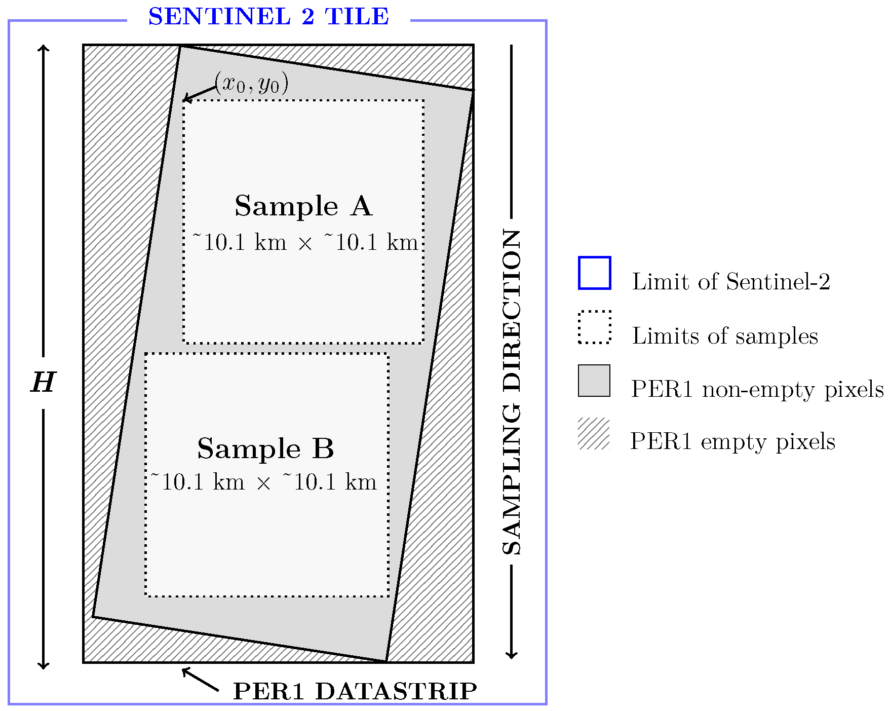
Given the pixel-by-pixel research approach and batch data processing requirements, variations in the dimensions and orientations of the PER1 datastrips (DS) posed significant challenges. Consequently, an algorithmic sampling method was employed to select square samples while accounting for empty pixels and datastrip geometry (Algorithm A1). Figure 1 illustrates this sampling process, addressing the challenges posed by image boundaries and empty pixels, which vary with each acquisition due to changes in geometry caused by operational conditions. This systematic approach enabled the generation of shapefiles, which were subsequently used to retrieve data from Google Earth Engine (GEE) and crop images from complementary sources.
Figure 1.
Sample geometry selection schema.
Additional steps included rasterizing, cropping, and generalizing the Climate Classification Land (CCL) vector data and generating secondary variables detailed in Appendix A. The CCL originally integrates the three Thornthwaite indices [28], but only the Thermic Efficiency Index (TEI) was prioritized for atmospheric correction. Then, the CCL was reclassified to focus solely on TEI, ensuring sufficient samples per class.
After acquiring all the required data, it was necessary to match the relative positions of PER1 and S2 pixels in each corresponding image. PER1 images were converted to TOA reflectance using Equation (2) and resampled to 10 m to match S2 pixels. The Sun-Earth distance correction factor d for this conversion was computed using an approximation approach from Mather and Tso [40]. This procedure was applied to all sample sets:
where are the row, column, and band indices of PER1 pixels; is the TOA reflectance; is the pixel’s Digital Number; and are the radiometric gain and integrated solar irradiance for band b; is the Sun–Earth distance correction factor, calculated using Equation (3); is the Julian date of acquisition; and is the solar zenith angle.
Furthermore, geolocation accuracy differences between PER1 and S2 for each sample set were addressed through a two-step co-registration process. First, the upper-left corner of PER1 images was realigned to match their corresponding S2 images. Second, cross correlation in the frequency domain [41] was applied to refine the internal positions of PER1 pixels using Equation (4). This algorithm optimized alignment by adjusting rows and columns while preserving the geolocation. After alignment, displaced rows and columns were removed, and the datasets were re-cropped to fit the updated geometry. This initial resampling and alignment ensured a global spatial match across sample sets (Figure A2):
where are the PER1 image displacements in x and y directions; F is the Fourier Transform; is the inverse Fourier Transform; and * denotes the complex conjugate.
Despite initial alignment, some images still contained missing values (NaNs) due to incomplete frames, data source limitations, or coverage gaps. Additionally, pixel intensity differences between PER1 and S2 at TOA persisted (Figure A4), caused by distinct spectral response functions, ground sample distances (GSDs), integration times, and minor angular mismatches, affecting pixel-by-pixel comparisons even for the same land class. Therefore, a preprocessing stage was implemented to identify the “most similar” PER1 and S2 pixels at TOA, relying on the high-quality BOA benchmark provided by S2 to approximate the most comparable PER1 pixels.
2.3. Dataset Preprocessing
The preprocessing stage ensured the selection of the most similar PER1 and S2 TOA pixel pairs, along with their ancillary data. Each sample set, defined as a specific subset of data corresponding to a pair of PER1 and S2 coincidences along their with corresponding ancillary data, was converted to the comma-separated values (CSV) format. In this format, rows represented pixels, and columns contained variable values. The global dataset, encompassing all sample sets, retained an index linked to PER1 identifiers and pixel numbers to maintain traceability throughout the subsequent filtering steps.
The initial data cleaning focused on removing rows containing NaNs. Additionally, clouds and cloud shadows (clouded pixels in advance) needed to be masked, as comparisons between clouded and clear pixels were unreliable. Even matching in cloud or shadow between images, multisource pixel values can be inconsistent due to differences in the sensor dynamic range and saturation level. Therefore, extremely saturated and negligible reflectance pixel values were excluded.
To mask cloudy and shadowed pixels, S2’s Scene Classification Land (SCL) map was used; however, PER1 lacked similar classifiers. To address this, a pixel-based neural network (NN) was trained using the analogous S2 TOA bands corresponding to the PER1 bands as inputs and the SCL maps as outputs. Subsequently, PER1 TOA data were normalized using min-max scaling to match S2 and processed with the trained model. Although effective in most cases, the model misclassified some cloudless pixels (Figure A3).
To improve masking, a second approach employed unsupervised k-means clustering with fixed clusters and centroids for each PER1 DS. A reference sample was selected per DS, and k-means was applied to this reference using a fixed number of clusters and centroids. To improve accuracy, a water index was added. Based on the high probability that nearby pixels belong to similar classes, the normalization parameters and centroids from the reference sample were retained to ensure consistent classification across other samples within the same DS (Algorithm A2).
For samples within a DS that displayed land cover notably different from the reference, masks were created by visually inspecting the clusters and selecting those corresponding to clouded-pixel classes. The final mask from both the NN and k-means approaches was added to the global dataset and indexed according to the PER1 initial indices.
After removing rows with missing values and cloud or shadow pixels, an initial outlier removal was conducted. This filtering employed Z-score normalization and the Mahalanobis distance (Equations (5) and (6)), accounting for variance and covariance among all bands to detect and eliminate outliers. This stage focused exclusively on statistical outliers without considering broader contextual factors:
where is the Mahalanobis distance; x is the vector of observations (data point); is the mean vector of the distribution; is the inverse of the covariance matrix S; and T denotes the vector transpose. Z is the normalized data, X the original data, the mean, and the standard deviation of the dataset.
For the secondary cleaning process, recognizing that data quality relies not only on statistical metrics but also on contextual consistency, domain knowledge was integrated into the process [42]. This approach allowed for the consideration of intrinsic relationships and correlations across all bands, moving beyond the assessment of individual pixel values, which is particularly important for batch processing.
In this contextual approach, “most similar” referred to those PER1 and S2 pixel pairs belonging to the same class and exhibiting high similarity across all bands while maintaining consistency within the total scene context. For instance, although two pixels might show high similarity in one or more bands, discrepancies in another band could lead to inconsistencies within the selected pairs (Figure A4). To ensure robustness, all bands for each pixel were required to exhibit closely correlated TOA reflectance, retaining only those pixels with consistent multiband similarity.
This process relied on the nearly simultaneous acquisition and similar geometric conditions of PER1 and S2 images, which suggested a strong linear relationship between their TOA reflectance. To identify the most similar pixels, linear regression without an intercept was applied to the TOA pixel pairs. Subsequently, the Mahalanobis distance was used to detect pixels significantly deviating from this linear relationship, always accounting for the multivariate data context [43].
To further refine the dataset, the Mahalanobis distance probability threshold was iteratively adjusted, removing outliers until the all-band Pearson correlation coefficient for each sample set reached 80%, 85%, 90%, and 95%. This iterative process balanced high correlation with sufficient dataset size, ensuring the remaining data were both highly similar and contextually relevant. The steps for this contextual iterative data cleaning are detailed in Algorithm A3.
Finally, the dataset underwent a final cleaning stage by calculating the absolute error between the predicted and actual values from the linear regression for each sample set. Rows where the error exceeded 2 were removed, as this range corresponds to approximately 95% of the data in a normal distribution, providing a robust threshold for detecting outliers. The linear relationship coefficients derived from TOA comparisons for each sample set were then used to adjust S2 BOA reflectance to match the expected PER1 BOA values. As a result of this process, a final dataset was obtained for subsequent machine learning experiments, ensuring high data quality by removing statistical outliers and retaining only the most relevant pixel pairs.
2.4. Machine Learning Experiments
The machine learning experiments were designed to develop models capable of predicting BOA reflectance based on the independent variables.The study employed both Multiple Linear Regression (MLR) as a linear approach and Feedforward Neural Network (FFNN) techniques for capturing nonlinear relationships. The processed tabular dataset was split into training and validation sets using an 80/20 ratio. Prior to modeling, all variables were normalized using min-max scaling, and the scaler parameters were saved for future predictions to ensure consistency.
The independent variables included the normalized VIS-NIR PER1 TOA reflectance bands, along with related variables such as Aerosol Optical Depth (AOD), Water Vapor Column (WVC), Ozone (OZ3), Nadir Bidirectional Reflectance Distribution Function Adjusted Reflectance (NBAR), Digital Elevation Model (DEM), terrain characteristics (aspect, slope, shadows), and PER1 sun–sensor acquisition geometry values (see Table A1). Additionally, Climate Classification Land (CCL) was included using one-hot encoding. The dependent variable was the S2 BOA reflectance, previously adjusted using linear relationship coefficients derived from TOA comparisons for each sample set.
The objective was to identify the most effective model—or combination of models—for integration into a specific atmospheric correction processor for PER1. The performance of MLR and FFNN was evaluated against four key criteria: accuracy, precision, generalization capability, and coherence with domain knowledge. A detailed discussion of these criteria and the specific metrics used is provided in Section 3.2.3.
2.4.1. Multiple Linear Regression Approach
The MLR model estimates the linear relationship between a dependent variable and multiple independent variables (Equation (7)). MLR was applied to each spectral band separately, using the Ordinary Least Squares (OLS) method to minimize the Mean Squared Error (MSE) between the predicted and actual BOA values. By modeling these linear associations, MLR served as a baseline within a broader strategy to compare the linear and nonlinear techniques, aiming to assess the ability of linear models to capture relationships between variables for atmospheric correction:
where i indexes the observations, is the dependent variable, represents the j-th independent variable for observation i, is the intercept, are the slope coefficients for each independent variable, and is the residual error term.
2.4.2. Feedforward Neural Network Approach
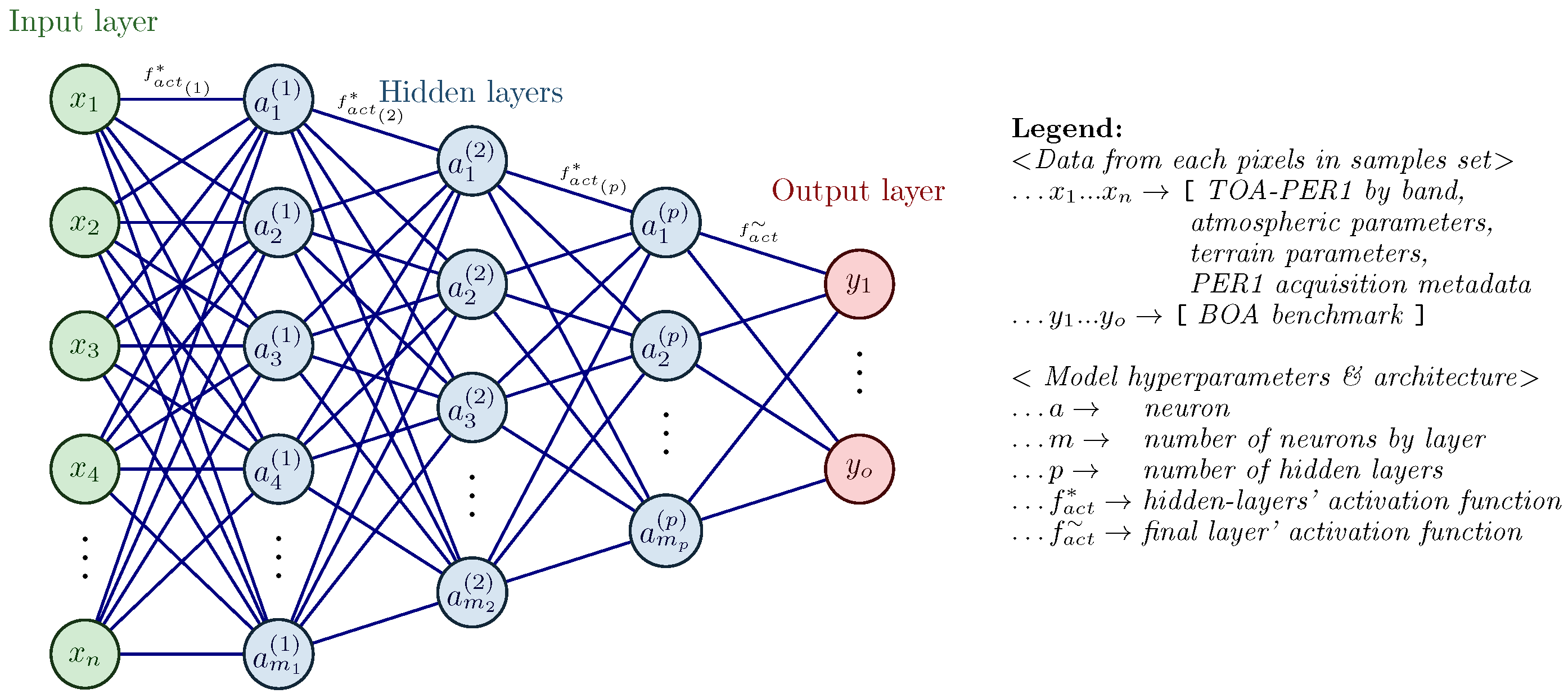
Architectural design and hyperparameter definition are critical factors in neural network modeling. In this study, a fully connected neural network architecture was employed, consisting of an input layer corresponding to the independent variables, followed by hidden layers with decreasing numbers of neurons to capture hierarchical feature representations. This design aimed to reduce complexity in deeper layers and mitigate overfitting by progressively abstracting features. The output layer used a linear activation function to predict continuous BOA reflectance values (a schematic is presented in Figure 2).
Figure 2.
Modeling approach schema for feedforward neural network experiments.
During the initial modeling phase, Keras Tuner was utilized to explore hyperparameters and narrow the search space. Key hyperparameters—such as neuron count, number of hidden layers, batch size, learning rate, and L2 regularization—were evaluated using 5-fold cross-validation on 30% of the dataset. The activation function evaluations at this stage focused solely on assessing the performance of linear (identity) and nonlinear activation functions. This process aimed to identify 2–3 optimal options per hyperparameter, resulting in a manageable set of configurations for further experimentation. Keras Tuner’s grid search and Bayesian optimization methods enabled efficient exploration of promising configurations while managing computational cost.
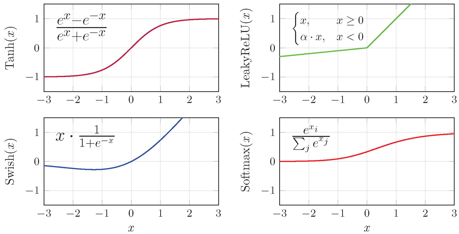
A secondary exploration, based on the previously narrowed hyperparameters, focused on selecting activation functions, as they play a critical role in the model’s ability to learn complex nonlinear relationships and significantly impact overall performance and generalization capacity [44,45,46]. Figure 3 illustrates the activation functions considered in this study, highlighting both monotonic (Tanh and Leaky ReLU) and non-monotonic (Swish and Softmax) behaviors. This stage consisted of two parts: first, evaluating the performance of activation functions under ceteris paribus conditions, and second, testing the best activation functions while combining all narrowed hyperparameters over 50% of the dataset. The objective was to define the top-performing configurations.

Figure 3.
Activation functions tested in the neural network model.
Finally, the top configurations were trained on the entire dataset. Batch normalization was applied to stabilize training and accelerate convergence, while dropout layers acted as a regularization mechanism to mitigate overfitting. The Adam optimizer, combined with the Mean Squared Error (MSE) loss function, ensured efficient weight updates. Additionally, adaptive learning rate scheduling and early stopping were employed to improve convergence and prevent overfitting [47,48,49]. A systematic logging system was implemented to track hyperparameter combinations, ensuring reproducibility and efficient experimentation. By leveraging these techniques, the FFNN approach aimed to capture nonlinear relationships in the data that linear models might overlook.
3. Results
3.1. Final Dataset
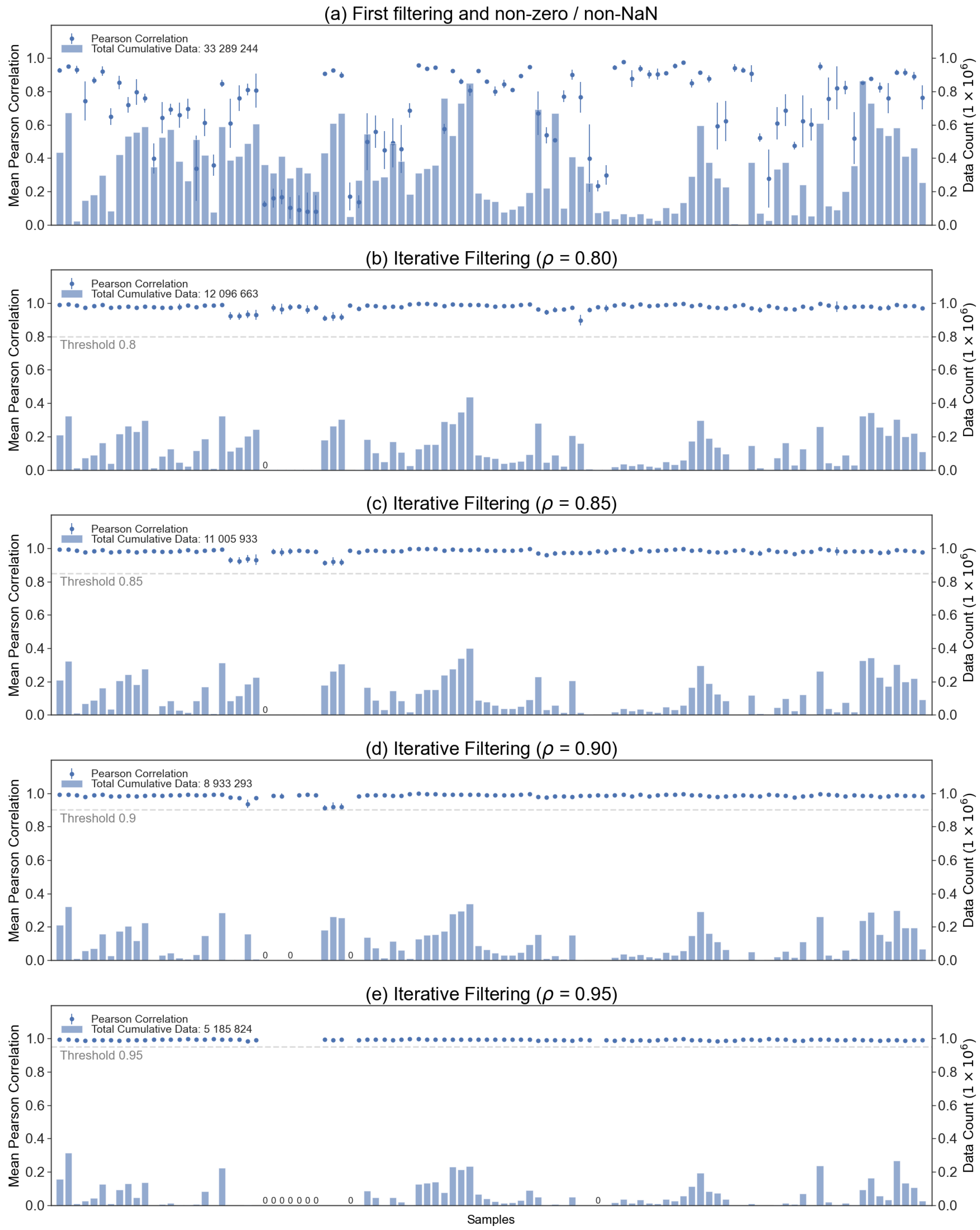
As shown in Figure 4, correlations between PER1 and S2 at TOA initially remained inconsistent across bands, with error bars indicating variability and low mean Pearson Correlation (PC) values. The contextual iterative filtering process improved these correlations by selecting the most similar pixels. Among the tested thresholds, the 90% distance threshold was the most efficient, retaining substantial data while achieving strong correlations for the remaining samples.
Figure 4.
Iterative filtering results.
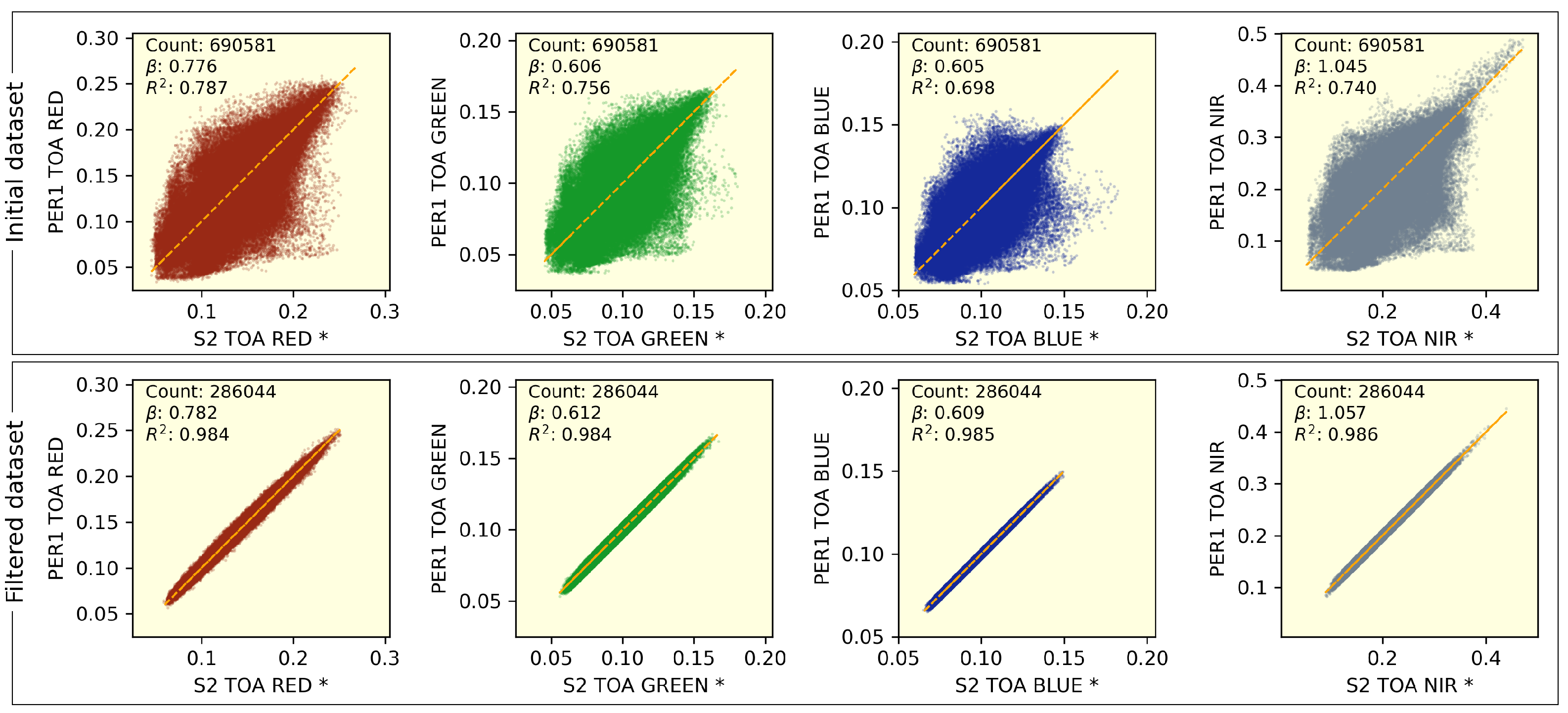
Figure 5 illustrates the band-by-band linear relationship between the TOA reflectances of S2 and PER1 before and after iterative filtering for a representative sample set. Initially, the R2 values ranged from 0.698 to 0.787. After filtering, these values improved significantly, reaching a range of 0.984 to 0.986, indicating a much stronger and more stable linear relationship at both global and band-specific levels. Likewise, the linear adjustment coefficients () showed only slight variations, suggesting that the global trend was preserved.
Figure 5.
Band-by-band linearities of PER1 and S2 TOA reflectances for initial and filtered datasets. The asterisk (*) indicates that the S2 TOA reflectances were “compensated” by multiplying them with the linear regression factor .
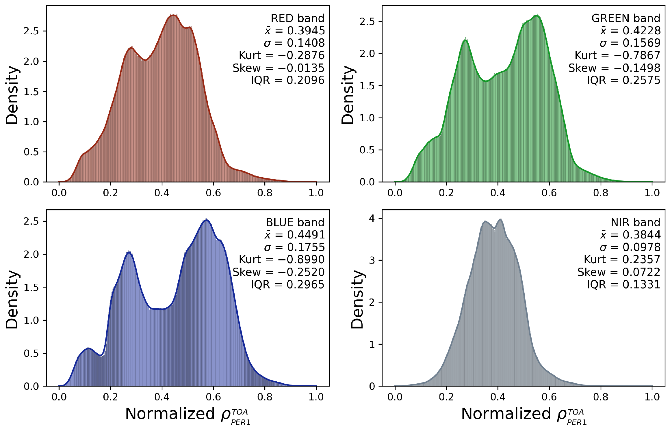
Figure 6 shows histograms of normalized TOA reflectance for each band, highlighting the dataset’s distribution characteristics. The RGB-VIS bands exhibit bimodal distributions, likely representing vegetated and non-vegetated areas, with wide histogram widths that capture the variability across the study area. In contrast, the NIR band shows a narrower and more symmetric distribution, reflecting less variability in this spectral range. Overall, these distributions reveal a diverse and class-heterogeneous final dataset that was employed for the machine learning experiments.
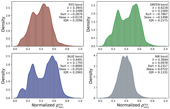
Figure 6.
Normalized PER1 TOA reflectance histograms by band in the final dataset.
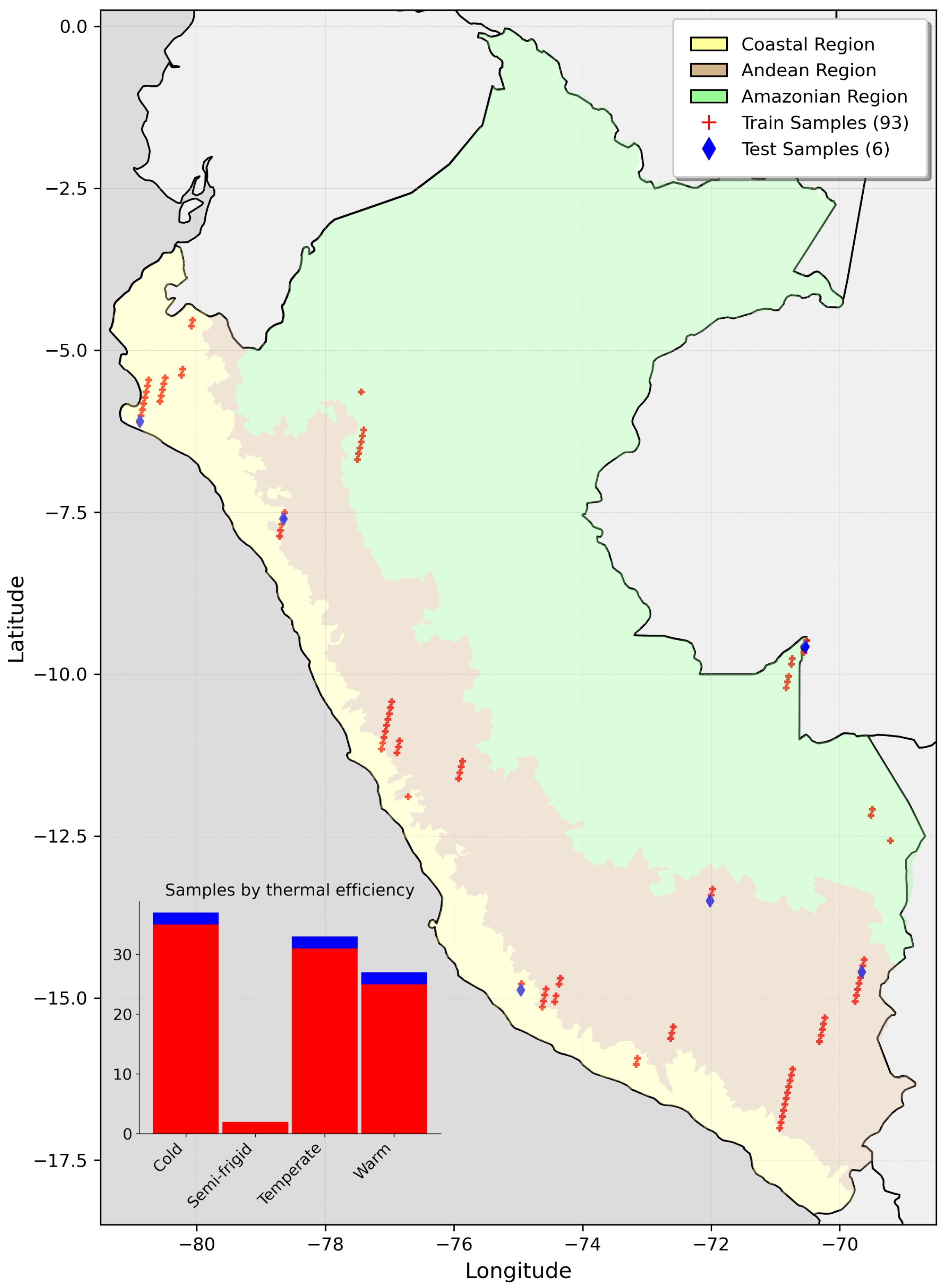
Finally, Figure A5 illustrates the spatial distribution of the final sample sets across Peru’s natural regions and their categorization by surface thermal efficiency. This distribution achieved a reasonably robust coverage across different areas, ensuring that the selected PER1 TOA pixels captured a broad representation. With nearly 9 million sampled pixels, this dataset was well-suited for machine learning experiments, contributing to model robustness and supporting the development of algorithms for atmospheric correction across diverse environmental settings.
3.2. Machine Learning Experiments Results
3.2.1. Multiple Linear Regression Approach
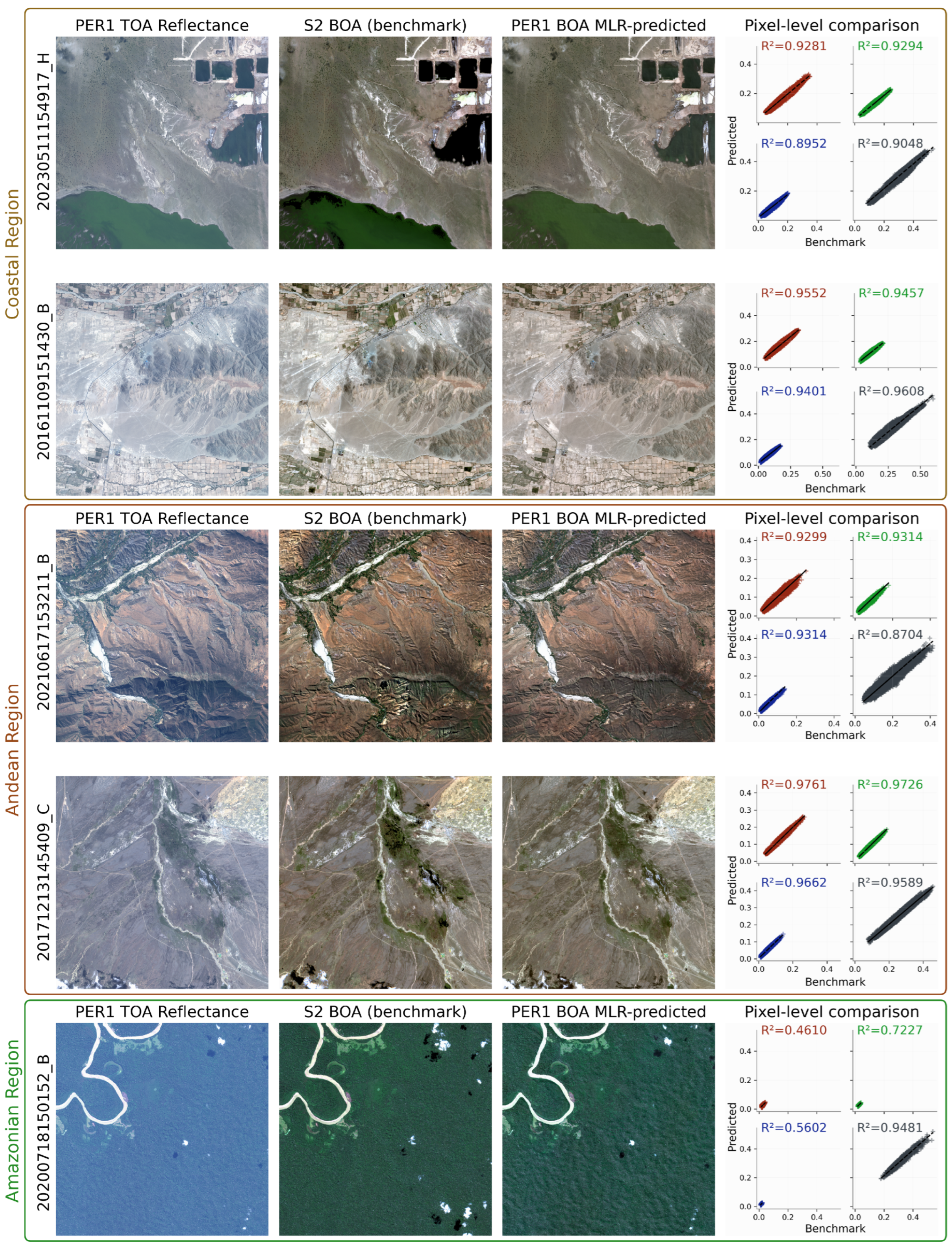
Figure 7 shows the results of MLR, comparing the predicted images and values against the benchmark. Scatter plots by band numerically assess the validation pixels, while, for visual evaluation, the 99th percentile of PER1 TOA reflectance was calculated and used to define a consistent drawing scale. Subsequently, both TOA and predicted values were mapped to this scale, preserving their relative differences. This approach highlights the variation in corrected reflectance with respect to TOA, ensuring comparable visual representations.
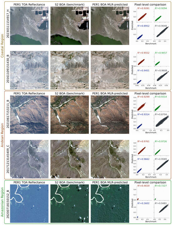
Figure 7.
Results of the Multiple Linear Regression approach.
The MLR model achieved strong performance across most validation samples, with R2 > 0.90 for the red, green, and NIR bands, effectively capturing linear relationships between input variables and BOA predicted reflectance. However, sample 20200718150152_B showed lower R2 values across bands, except for NIR. This case may be attributed to the dominance of dense vegetation in the scene, creating shadows visible in the PER1 TOA and predicted images but less pronounced in the S2 benchmark. These differences, likely due to slight variations in the sensor acquisition angles, warrant further investigation.
Overall, MLR proved to be a robust baseline approach, providing reliable predictions for linear relationships while serving as a reference for evaluating more complex models.
3.2.2. Feedforward Neural Network Regression Approach
Hyperparameter tuning using Keras Tuner identified optimal ranges for the model architecture, as summarized in Table 1. Both linear (identity) and nonlinear activation functions (Leaky ReLU, Tanh, Swish, and Softmax) were tested, with nonlinear functions generally showing superior results. The tuning process defined 2–3 hidden layers as optimal, and while networks of this depth exceed simple neural networks, they do not fully align with the criteria for “deep learning” as commonly defined [50,51,52]. To maintain clarity, this study refers to the explored architectures as Feedforward Neural Networks (FFNNs).

Table 1.
Keras Tuner optimized hyperparameter ranges.
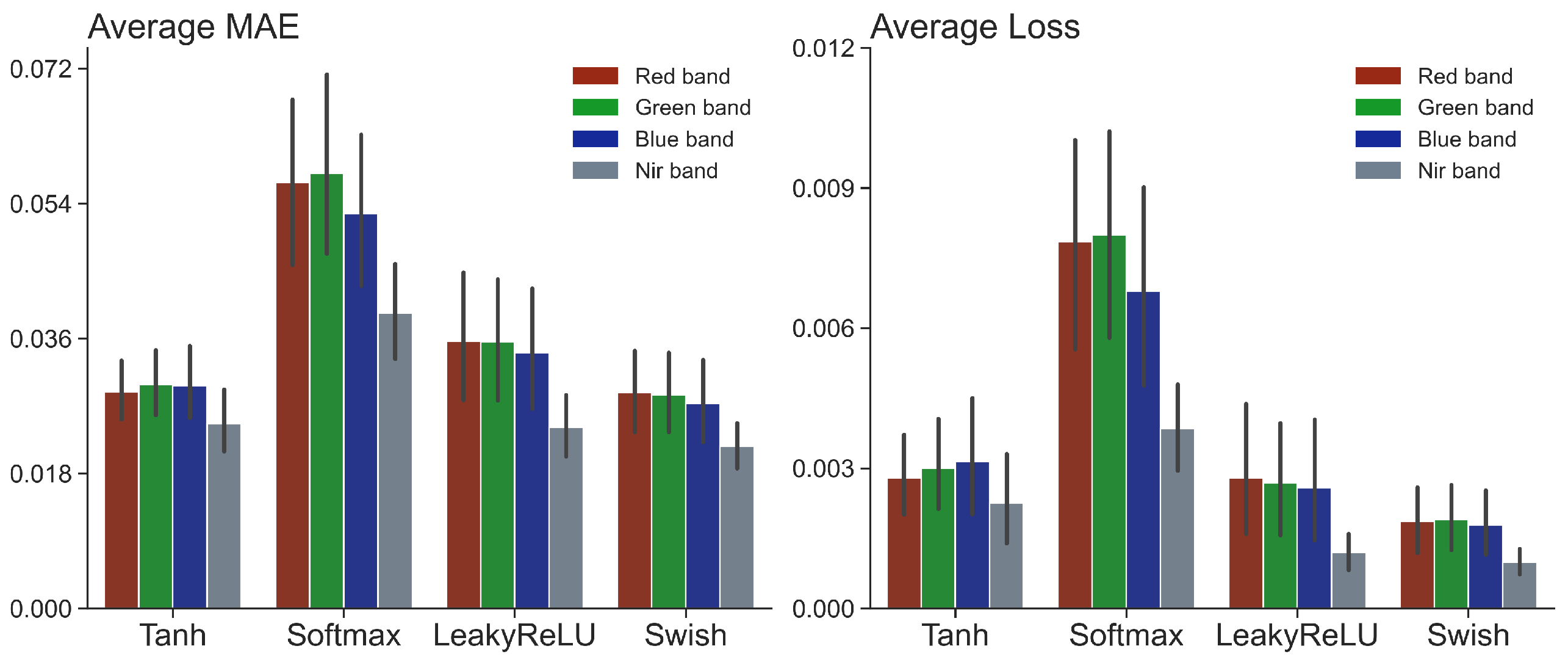
Regarding the selection of appropriate nonlinear activation functions, preliminary tests were conducted using 30% of the dataset to compare monotonic functions (Leaky ReLU and Tanh) with non-monotonic functions (Softmax and Swish) under a ceteris paribus condition. These tests revealed that Softmax exhibited the poorest performance, with significantly higher loss and MAE values, confirming its unsuitability for regression tasks (Figure 8). Consequently, Softmax was excluded from subsequent evaluations. The remaining functions—Swish, Leaky ReLU, and Tanh—were subsequently assessed using 50% of the dataset to identify their optimal configurations.
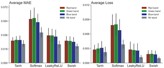
Figure 8.
Comparison of activation functions for regression tasks.
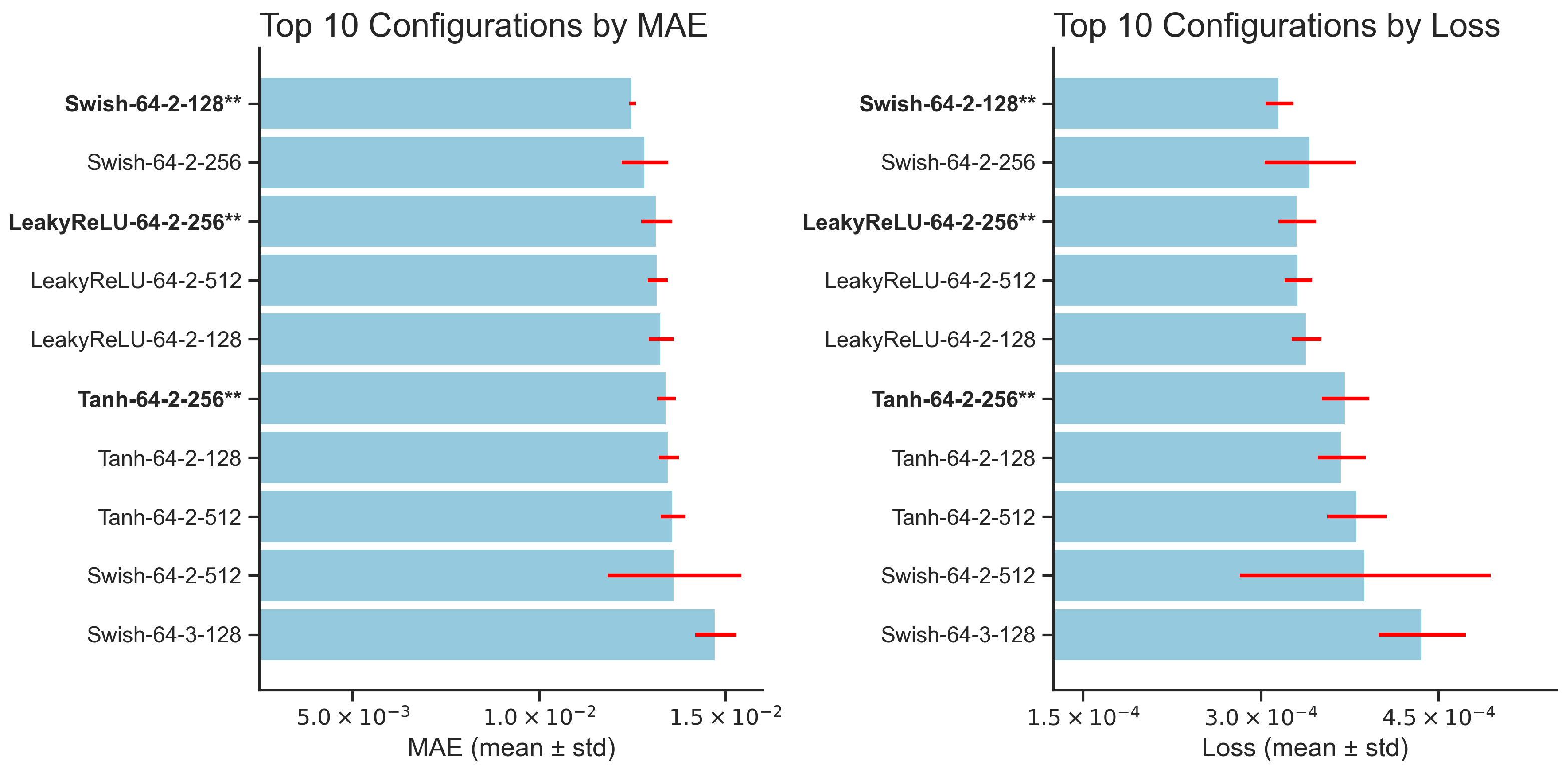
Figure 9 presents the top 10 configurations obtained for the three selected activation functions. Swish achieved slightly better MAE and loss values with its top configuration consisting of 64 neurons, 2 hidden layers, and batch sizes of 128 or 256. However, it exhibited significant variability in loss across configurations, with only its best setup demonstrating stability in MAE. The remaining configurations were notably less stable, which limited its overall reliability.
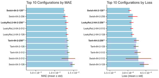
Figure 9.
Final evaluation of neural network architectures based on MAE and loss. The best-performing options for each activation function are highlighted.
Leaky ReLU ranked second in MAE performance but outperformed Swish in stability. Its top three configurations delivered consistently strong and stable results for both MAE and loss, demonstrating reliability across metrics and surpassing Swish in overall robustness. Tanh ranked third, achieving competitive MAE values but showing higher loss variability compared to Leaky ReLU, which limited its applicability in scenarios requiring consistent performance.
Based on this ranking, the best configurations for each activation function (highlighted in bold and marked with asterisks in Figure 9) were selected to train the FFNN models on the complete dataset. Each configuration label includes the activation function name, along with the numeric values for initial neurons, hidden layers, and batch size (e.g., Swish-64-2-128).
Table A2 presents the validation results for each activation function, elucidating their distinct performance characteristics. Swish achieved R2 values exceeding 0.90 in the majority of samples, albeit exhibiting slightly diminished performance in the red and blue bands, particularly in sample 20200718150152_B. This suggests a heightened sensitivity to specific bands in complex scenarios. Leaky ReLU exhibited balanced and reliable performance across all bands and samples, ensuring stable predictions under diverse conditions. Tanh generally attained the highest R2 values but exhibited moderate variability in performance, notably in the blue band, which may limit its applicability in contexts demanding consistency across all bands.
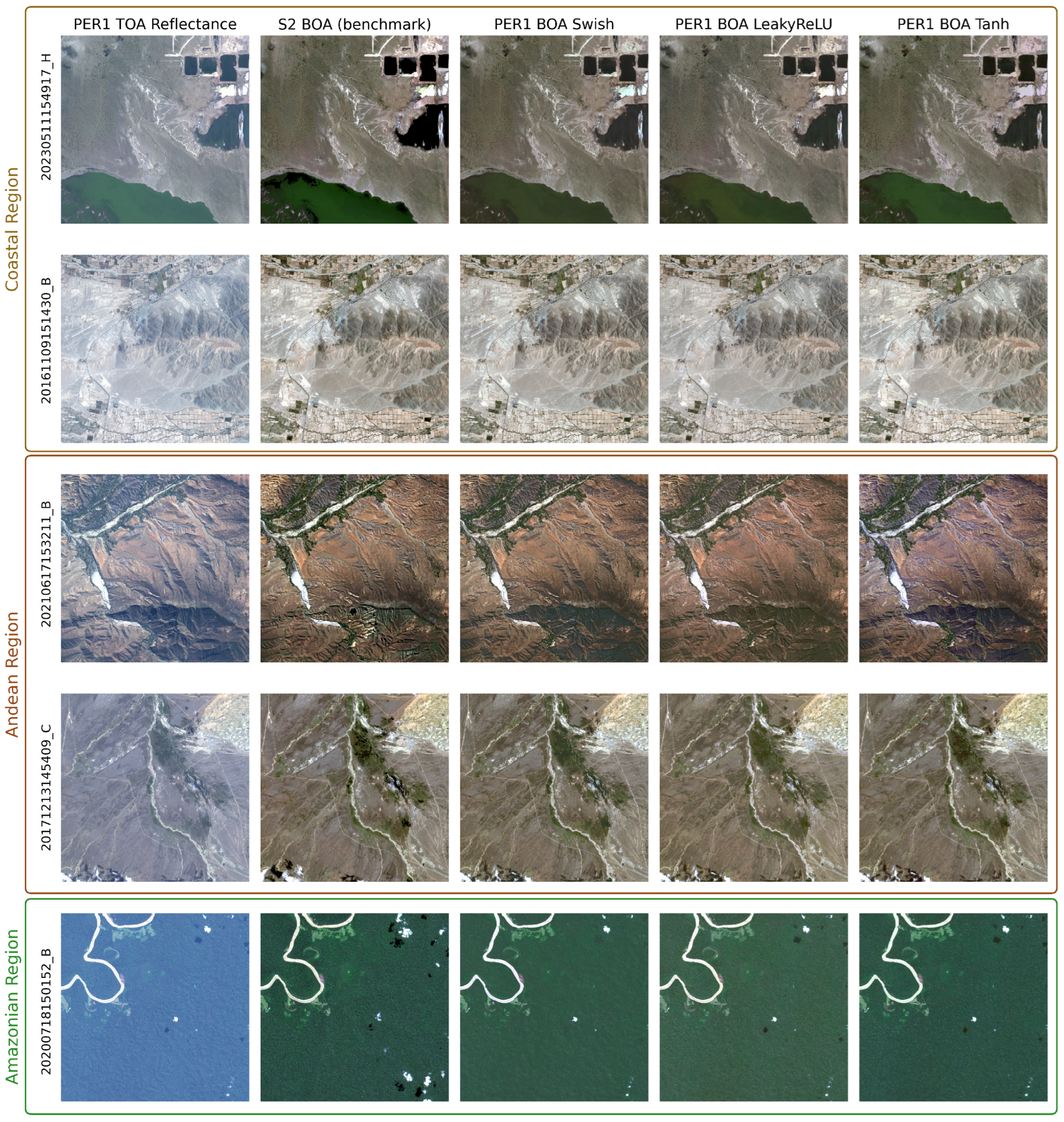
Visually, as depicted in Figure 10, all models yielded satisfactory predictions, albeit exhibiting discernible variations in color representation. As elucidated in Section 3.2.1, the images underwent normalization to the 99th percentile of their respective TOA. The observable variations encompass color saturation: Tanh imparts a reddish hue, particularly evident in sample 20210617153211_B and certain sandy regions of sample 20230511154917_H. Although less pronounced, this effect is also discernible with Swish. Leaky ReLU exhibits diminished green color accuracy in the Amazon region (sample 20200718150152_B), likely attributable to the shadow-induced roughness in this sample, as previously discussed. Notably, it circumvents the saturation issues observed with the other activation functions, providing more consistent color representation despite its limitations in specific scenarios.
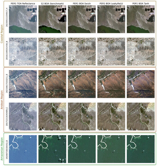
Figure 10.
Visual evaluation of FFNN predictions across different activation functions.
3.2.3. Global Evaluation of Machine Learning Models Performance
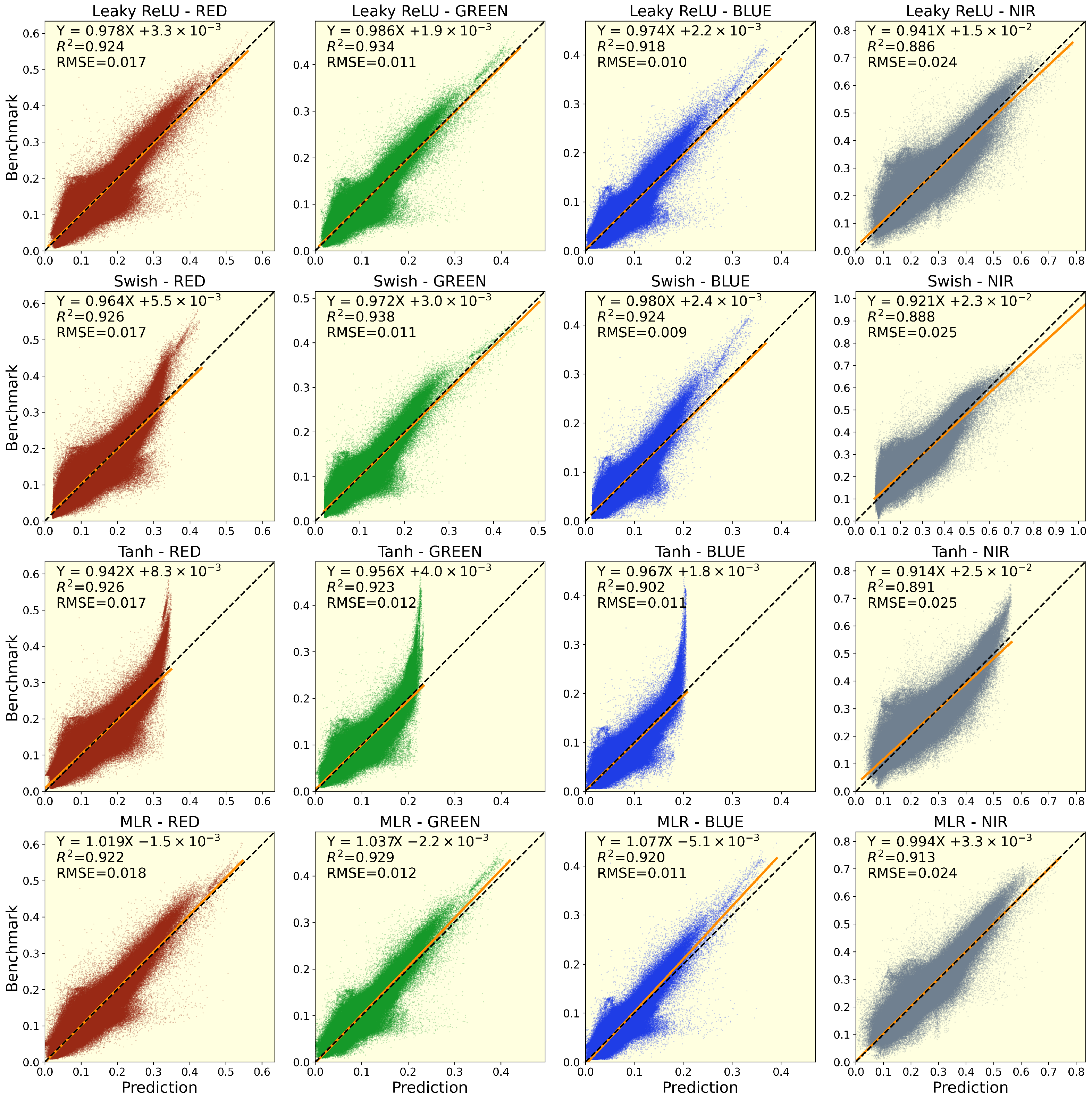
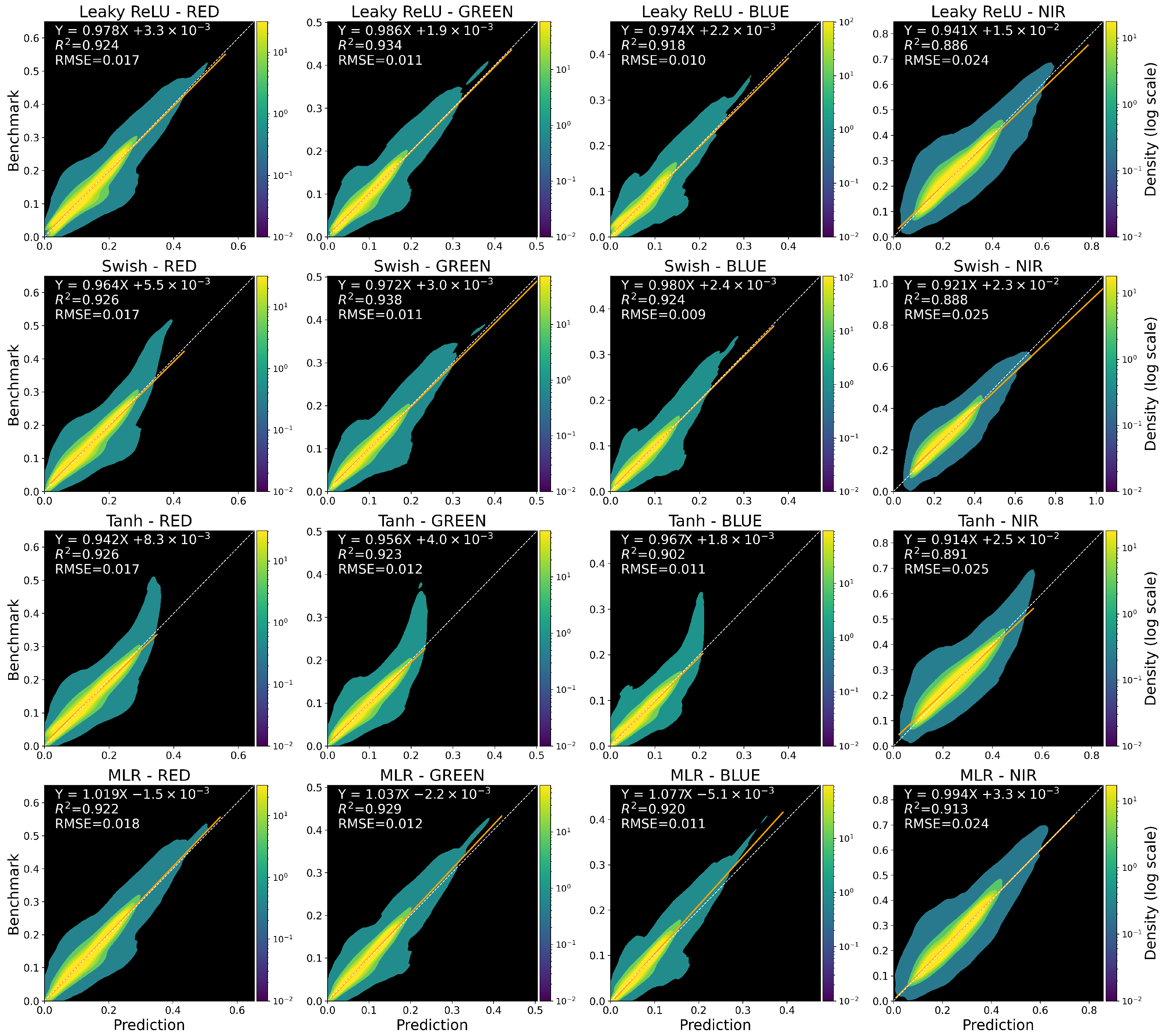
The models’ performance was assessed using four key criteria: precision, accuracy, generalization capacity, and domain-specific knowledge. To visualize these criteria, Figure 11 (scatter plots) and Figure 12 (density plots) illustrate the global performance evaluations, grouped by model type (rows) and spectral band (columns). To reduce bias, the sample 20200718150152_B was excluded, and benchmark pixels classified as water, clouds, and cloud shadows were removed from the test dataset.
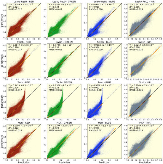
Figure 11.
Scatter plots evaluation of machine learning models for spectral band predictions.
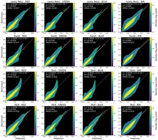
Figure 12.
Density plots evaluation of machine learning models for spectral band predictions.
The regression lines between the predicted and benchmark values, represented by the equation (where is the slope and is the intercept), are shown as orange lines, with a dotted line indicating perfect predictions. Each subplot includes the Coefficient of Determination (R2) and Root Mean Squared Error (RMSE), which help to assess the model’s performance. The scatter distributions, regression fits, and density patterns reveal how each model responds at different reflectance values.
Precision is defined by how tightly the predictions cluster around the trend line. In this study, was used to assess the global dispersion of predictions. Higher values signify greater precision and tighter clustering of predictions around a linear trend, indicating more reliable model behavior.
Accuracy, defined as the numerical proximity between predicted and actual values, is assessed in two ways: Firstly, a value closer to 1 indicates higher accuracy. Secondly, prediction error is evaluated using both global and local approaches. Globally, RMSE measures overall model error, with lower RMSE values indicating higher global accuracy. Locally, the relative error (RE) in percentage terms (Equation (8)) quantifies the proportional error at the pixel level, offering a more refined measure of model performance:
where is the actual values, and is the predicted values.
Numerical metrics alone are inadequate for a complete evaluation, as strong metrics may not always guarantee the overall model performance across diverse scenarios. Therefore, additional criteria are employed. Generalization capacity refers to the model’s ability to predict across the full range of benchmark values, whereas domain-specific knowledge ensures that predictions are realistic and physically plausible, while assessing the model’s adaptability to the specific problem at hand.
Density plots provide additional insights into the distribution of predicted versus actual values. These plots are particularly useful for identifying areas of high concentration that might be obscured by the point cloud dispersion in scatter plots.
Swish exhibited strong numerical performance in terms of precision and accuracy, with coefficients , , , and RMSE ranging from to . However, scatter and density plots revealed irregularities in the red band, including non-uniform distributions at mid-range predictions and deviations at high reflectance. Meanwhile, the green and blue bands performed well, with values of and . Swish’s reliability was reduced due to inconsistent generalization in the red band. Despite this, it remains a promising model with potential for further optimization.
The Tanh function’s generalization capacity was notably limited, particularly at high reflectance levels. Despite respectable coefficients , , , and RMSE ranging from to , its predictions were compressed to ranges near half of the maximum expected values as indicated by scatter and density plots. Consequently, under the proposed approach, Tanh is deemed unsuitable.
Leaky ReLU demonstrated balanced performance across all spectral bands, with coefficients , , , and RMSE values ranging from to . Scatter and density plots revealed consistent clustering around the regression line, ensuring reliability across both low and high reflectance. Except for the NIR band, Leaky ReLU outperformed other models in terms of global accuracy, with minimal RMSE and values closer to 1 for visible bands. In terms of generalization, this model demonstrated robust predictive capability across the entire benchmark range. Focused on the problem at hand, the visible bands (red, green and blue) are relatively more important than NIR for most users of the PER1 system.
MLR demonstrated stable performance with coefficients , , , and RMSE ranging from to . However, except for the NIR band, its coefficients were the furthest from 1 when compared to other models, resulting in the overestimation of reflectance, particularly in the blue band, where high scattering causes nonlinearities that MLR could not fully capture, reducing its accuracy in certain spectral bands. The model’s intercepts () were negative along the visible spectrum, which could lead to physically implausible reflectance predictions. Although the MLR predictions got better precision by clustering along its regression line, being the most consistent in scatter and density plots, its inability to handle nonlinearities prevented it from aligning more closely with the identity line compared to Leaky ReLU. Despite its limitations in the visible spectrum, the MLR model for the NIR band is effective and can be used in conjunction with Leaky ReLU for the atmospheric correction pipeline.
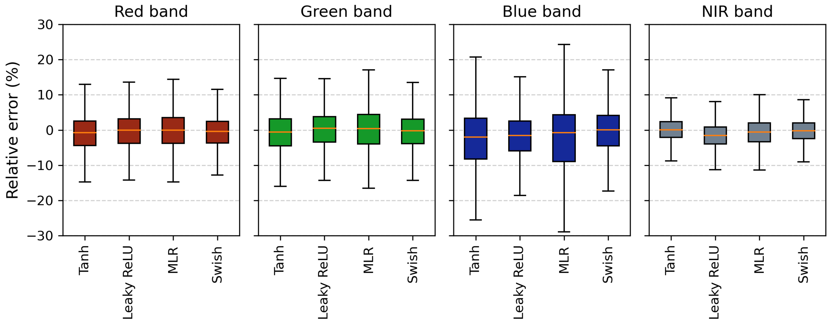
The previous analysis assessed the model performance results in the frame of the four key criteria at the global level. However, RMSE is insufficient due to its minimal differences across bands, with an average of . Additionally, RMSE may be influenced by large data values, which can obscure differences in local performance. Therefore, Figure 13 provides a comparative distribution of percentage relative error across methods and spectral bands. This last metric quantifies the local prediction error without being affected by pixel magnitude. Models with narrower ranges and medians closer to zero indicate higher reliability; conversely, a wider range indicates higher probability of obtaining bigger errors at the pixel-level predictions. In this figure, Swish shows good performance, but it was discarded due to its weak generalization capability. Leaky ReLU is the next activation function with the narrowest error ranges across bands, supporting its RMSE results, while MLR is the model with the poorest performance results for the visible spectrum.

Figure 13.
Relative error distribution across spectral bands for different machine learning models.
At the band level, the NIR band showed the smallest error range and least variability across methods, attributed to the reduced atmospheric scattering at longer wavelengths. In contrast, the blue band exhibited the largest relative error range, particularly for MLR and Tanh, with relative errors reaching up to 30%, highlighting the challenges of correcting shorter wavelengths prone to atmospheric interference. The red and green bands showed similar error distributions for all models, though MLR had slightly higher variability.
Overall, Leaky ReLU was identified as the most reliable method, outperforming others in both accuracy and reliability. Figure 11 and Figure 12 confirm its strong generalization across a wide reflectance range, while Figure 13 highlights its lower local error variability compared to MLR. Swish showed good performance but struggled in mid- to high-reflectance scenarios. Tanh suffered from compressed predictions and larger errors, compromising both precision and accuracy. MLR struggled with nonlinear atmospheric effects at shorter wavelengths but is the best option for the NIR band. Additionally, MLR is the only model with negative intercepts in the visible bands, leading to physically implausible predictions for low-reflectance scenarios. Consequently, Leaky ReLU is the most suitable model for the visible spectrum, while MLR performs better for the NIR band.
4. Discussion
The main objective of this study was to evaluate the efficacy of pixel-based machine learning methods for atmospheric correction by comparing model predictions with a benchmark. The results show that the FFNN with the Leaky ReLU activation function delivers the best overall performance in the visible spectrum, while the MLR model excels in the Near-Infrared (NIR) band.
The assessment of model performance emphasizes the critical role of domain-specific knowledge in ensuring methodological consistency with the physical principles of remote sensing. The narrow relative error range and superior performance of MLR in the NIR band are attributed to reduced atmospheric scattering and more linear relationships at longer wavelengths. In contrast, the FFNN with Leaky ReLU activation outperforms in the visible spectrum due to its enhanced capability to capture complex, nonlinear atmospheric effects. This distinct performance is consistent with the underlying physical phenomena, thereby validating the plausibility of the proposed methodology.
Furthermore, the validation of these methods highlights their potential for scalability and broader application. The developed methodology provides a tailored solution for implementing an atmospheric correction pipeline specific to PER1. Additionally, it holds promise for adaptation to other sensors with similar characteristics, fostering interoperability with widely used systems such as Sentinel-2. By leveraging reliable benchmark data from different sensors, this approach enables dataset enrichment, further enhancing the precision, accuracy, and reliability of atmospheric correction methods using machine learning. Next, some key findings of the research are discussed.
4.1. Dataset Quality and Its Impact on Results
The dataset construction process provided a solid foundation for training the machine learning models. Using a 90% Pearson correlation threshold, a balance between data retention and global correlation quality was achieved during the cleaning and preprocessing stages. Furthermore, the spatial distribution of the final samples reflected a stratified sampling scheme that covered Peru’s main geographic regions and the thermal properties of the sampled surfaces. Key atmospheric variables, such as Aerosol Optical Depth (AOD), Water Vapor Column (WVC), and Ozone (OZ3), were included due to their known relevance in atmospheric correction, ensuring a robust dataset for training.
However, the spectral values in the red, green, and blue bands displayed bimodal distributions with lower normality compared to the NIR band, which exhibited a distribution closer to normality. This disparity may also have contributed to the relative stability of machine learning models in the NIR band compared to the others as evidenced by its lower error variability and consistent performance across all models. Expanding the dataset to include a broader range of samples, including conditions that promote greater spectral normality for all bands, could enhance the models’ performance.
4.2. Machine Learning Model Performances by Spectral Band
The pixel-based machine learning approach proved effective, supporting the development of an atmospheric correction pipeline for PER1. However, local error comparisons revealed variability across spectral bands. The NIR band showed consistent relative error performance across all models, whereas the red, green, and blue bands—particularly the green and blue in the MLR model—exhibited greater error variability.
This variability may result from the previously discussed bimodal distributions and distinct sensitivity to atmospheric effects, such as scattering and background noise, which are more pronounced at shorter wavelengths. Linear models like MLR struggled to account for these nonlinear influences, while the FFNN achieved better results by capturing more complex relationships.
Overall, the findings underscore the significant role of spectral characteristics in atmospheric correction accuracy. They also highlight the importance of considering sensor-specific spectral properties when selecting correction methods. Expanding the dataset to include more diverse samples could further enhance model performance by improving representativeness and enabling better learning from a wider range of surfaces and conditions.
4.3. Effect of Activation Functions on Color
The choice of activation function in Feedforward Neural Network models significantly influenced both numerical accuracy and visual fidelity in atmospheric correction. Leaky ReLU demonstrated balanced performance across all spectral bands, effectively capturing variations without compressing high-reflectance levels. This resulted in stable predictions with precise spectral variability, making it an optimal choice for preserving chromatic fidelity in the visible (RGB) spectrum.
In contrast, Swish exhibited inconsistencies in the red band due to its self-modulating nature, impacting reliability in high-intensity reflectance scenarios. Tanh showed limitations in generalization, particularly for high reflectance values. Its bounded output compressed these levels, leading to subdued bright areas and potential color distortions. This effect was most pronounced in the red band, where reflectance values were compressed to approximately 0.35, but it was also observed in the green and blue bands, where compression occurred at lower levels (around 0.25), making red visually dominant.
These findings emphasize the importance of selecting activation functions suited for atmospheric correction, especially for the visible spectrum, which plays a crucial role in this study. Leaky ReLU offered a balance between flexibility and stability, effectively handling both low and high-reflectance values without significant color distortions. Future models could benefit from hybrid activation functions that combine their strengths or custom designs optimized for atmospheric challenges. Expanding the dataset with more diverse samples or employing more sophisticated architectures, could particularly benefit Swish, as it shows potential for further optimization. In contrast, Tanh’s limitations make it less suitable for significant improvements in this context. These refinements would address current limitations and enhance the performance of neural networks in atmospheric correction tasks.
4.4. Seasonal Effect on Model Precision
Seasonal variations were not explicitly investigated in this study, as reflectance is a relative measure that ideally remains consistency for non-dynamic surfaces. However, slight variations in model performance were observed across semesters. Errors were marginally higher in the second semester for the red, green, and blue bands, with mean absolute errors () ranging from ∼0.003 to ∼0.006 and uncertainties () of ∼0.003 for red, and ∼0.002 for green and blue. In contrast, the NIR band exhibited reductions in both (from ∼0.009 to ∼0.007) and (from ∼0.005 to ∼0.003), suggesting enhanced stability in the second semester. These variations could be attributed to seasonal factors such as changes in solar geometry, intensity, and sensor spectral sensitivities (Signal-to-Noise Ratio).
Due to the scarcity of validated data for all months of the year, it was not feasible to ascertain statistical significance or substantiate consistent trends. Nevertheless, these preliminary findings underscore the potential susceptibility of the models to seasonal variations, particularly under high-illuminated scenarios. Expanding the dataset to encompass samples from all seasons and incorporating a seasonal variable into the models would elucidate these effects. Such enhancements would fortify the model’s robustness under diverse conditions, thereby furnishing a more comprehensive comprehension of atmospheric correction across varying illumination and atmospheric scenarios.
4.5. Final Considerations and Future Directions
The pixel-based machine learning approach developed in this study has shown promising potential for the atmospheric correction of PER1 images by leveraging a robust dataset tailored to the satellite’s unique characteristics. While the models delivered strong results, limitations such as greater variability in the red and blue bands highlight areas for improvement to enhance stability and generalization.
Future research should prioritize optimizing model architectures to address the challenges associated with shorter wavelengths, where atmospheric scattering effects are more pronounced and entropy is higher, leading to more complex nonlinear relationships. Implementing advanced techniques, such as combining activation functions within custom architectures specifically designed for atmospheric correction, could help balance stability and non-linearity. These enhancements may also mitigate inconsistencies in scenarios characterized by high-intensity reflectance.
Expanding the dataset to include a broader range of spectral and seasonal examples, along with additional atmospheric variables like pressure and temperature, could significantly improve the models’ performance. These enhancements would not only strengthen the models’ generalization capabilities but also contribute to the development of a robust and adaptable pipeline tailored to Peru’s diverse landscapes and climatic conditions.
Such advancements would ensure reliable outputs for critical applications, including defense, security, and disaster management, while addressing challenges posed by varying atmospheric conditions. By refining the dataset and exploring complementary variables, future research could further optimize atmospheric correction for operational use across diverse scenarios. However, this may lead to higher computational costs, necessitating a careful trade-off between improved performance and resource requirements.
5. Conclusions
This study demonstrates the feasibility of pixel-based machine learning methods for atmospheric correction of PeruSAT-1 images. By leveraging a dataset specifically tailored to the satellite’s unique characteristics, including its variable viewing angles and non-uniform image dimensions, the proposed approach achieved results consistent with Sentinel-2 accuracy standards. These findings provide a solid foundation for developing an adaptable atmospheric correction pipeline that aligns with the operational needs of PeruSAT-1 users in critical areas such as defense, security, and disaster management, ensuring a balance between accuracy and feasibility.
The methodology is practical and scalable, relying on accessible data sources and enabling continuous dataset expansion. Incorporating additional spectral and seasonal data could further enhance the models’ generalization and robustness under diverse conditions. Furthermore, this approach opens opportunities to adapt the methodology to other satellite systems with similar characteristics, fostering the development of robust atmospheric correction pipelines by integrating data from sensors with high correction accuracy and spectral compatibility with PeruSAT-1.
Author Contributions
Conceptualization, L.S. and Y.T.; methodology, L.S.; formal analysis, L.S.; investigation, L.S.; resources, Y.T.; data curation, L.S.; writing—original draft preparation, L.S.; writing—review and editing, Y.T., N.S. and J.D.; visualization, L.S.; funding acquisition, Y.T. All authors have read and agreed to the published version of the manuscript.
Funding
This research received no external funding.
Data Availability Statement
The dataset generated is available upon request, subject to legal restrictions. Access to PeruSAT-1 original and derived data requires authorization from the Peruvian Space Agency (CONIDA), as outlined on the official website (https://www.gob.pe/8391-consultar-sobre-el-acceso-o-solicitud-de-imagenes-al-sistema-satelital-peruano (accessed on 20 November 2024)). Interested researchers should contact CONIDA for formal requests. Derived data supporting this study may be shared by the corresponding author, contingent on compliance with these regulations.
Acknowledgments
The authors wish to express their sincere gratitude to the Peruvian Space Agency-CONIDA for providing the PeruSAT-1 data. We also extend our appreciation to all institutions and organizations that supplied additional datasets and resources.
Conflicts of Interest
The authors declare no conflicts of interest.
Abbreviations
The following abbreviations are used in this manuscript:
| AOD | Aerosol Optical Depth |
| BOA | Bottom-of-Atmosphere |
| BRDF | Bidirectional Reflectance Distribution Function |
| CCL | Climate Classification Land |
| CNN | Convolutional Neural Network |
| CONIDA | Peruvian Space Agency (Agencia Espacial del Perú) |
| DEM | Digital Elevation Model |
| DS | Datastrip |
| FFNN | Feedforward Neural Network |
| GEE | Google Earth Engine |
| GSD | Ground Sample Distance |
| IGS | Image Ground Segment |
| L1C | Level-1C (Top-of-Atmosphere Sentinel-2 product) |
| L2A | Level-2A (Bottom-of-Atmosphere Sentinel-2 product) |
| L2H | Level-2H (Harmonized Sen2Like product) |
| LST | Local Solar Time |
| MAE | Mean Absolute Error |
| MLR | Multiple Linear Regression |
| MSE | Mean Squared Error |
| MS | Multispectral |
| MSI | Multispectral Instrument (Sentinel-2 sensor) |
| NAOMI | New AstroSat Optical Modular Instrument (PeruSAT-1 sensor) |
| NBAR | Nadir Bidirectional Reflectance Distribution Function-Adjusted Reflectance |
| NIR | Near-Infrared |
| OZ3 | Ozone |
| PAN | Panchromatic |
| PER1 | PeruSAT-1 |
| PC | Pearson Correlation |
| PMS | Pansharpened |
| R2 | Coefficient of Determination |
| RTM | Radiative Transfer Model |
| S2 | Sentinel-2 |
| SCL | Scene Classification Map |
| TOA | Top-of-Atmosphere |
| UTM | Universal Transverse Mercator |
| VHR | Very High Resolution |
| VIS | Visible |
| WGS84 | World Geodetic System 1984 |
| WVC | Water Vapor Column |
Appendix A. Variables and Data Sources Used in the Study
Table A1.
Variables and data sources used in the study.
Table A1.
Variables and data sources used in the study.
| Variables | Data Provider | Product | Data Range | Gridded Data |
|---|---|---|---|---|
| Primary Variables | ||||
| Aerosol Optical Depth (AOD) | ECMWF 1 | CAMS 2: “Total Aerosol Optical Depth at 550 nm” | 9.6 –3.58255 | 0.4° × 0.4° |
| Water Vapor Column (WVC) | NASA | MODIS MCD19A2 | 0–30 (cm) | 1000 m pixel |
| Nadir Bidirectional Reflectance Distribution Function Adjusted Reflectance (NBAR) | NASA | MODIS MCD43A4: - Band 1 (620–670 nm) - Band 2 (841–876 nm) - Band 3 (459–479 nm) - Band 4 (545–565 nm) | 0–3.2766 | 500 m pixel |
| Ozone (OZ3) | NASA | TOMS/MERGED | 73–983 (Dobson) | 1.0° × 1.0° |
| DEM | NASA | SRTM 90 | - | 90 m pixel |
| Climate Classification (CCL) | SENAMHI 3 | Peruvian Climate maps | 1–23 (classes) | - |
| Scene Classification Land (SCL) | ESA 4 | Sentinel-2–L2A SCL | 0–11 (classes) | 20 m pixel |
| TOA reflectance reference | ESA | S2–L1C | 0–1 (dimless) | 10 m pixel |
| BOA reflectance benchmark | ESA | S2–L2H | 0–1 | 10 m pixel |
| PER1 Data | CONIDA 5 | PER1–MS L3 | 0–4096 (DN) | 2.8 m pixel |
| Secondary Variables | ||||
| Terrain—Aspect | From DEM | Aspect map | 0°–360° | 10 m pixel |
| Terrain—Slope | From DEM | Slope map | 0°–90° | 10 m pixel |
| Terrain—Hill Shadows | From DEM | Hill shadows map | 0°–90° | 10 m pixel |
| PER1 Acquisition Geometry | CONIDA | Sensor & Sun Azimuth | 0°–180° | - |
| Sensor & Sun Zenith | 0°–90° |
1 European Center for Medium-Range Weather Forecasts; 2 Copernicus Atmosphere Monitoring Service; 3 National Service of Meteorology and Hydrology of Peru; 4 European Space Agency; 5 Peruvian Space Agency.
Appendix B
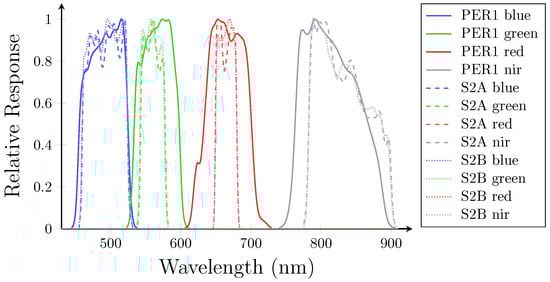
Figure A1.
Spectral response functions of PER1 and Sentinel-2, highlighting compatibility for benchmarking.
Figure A1.
Spectral response functions of PER1 and Sentinel-2, highlighting compatibility for benchmarking.
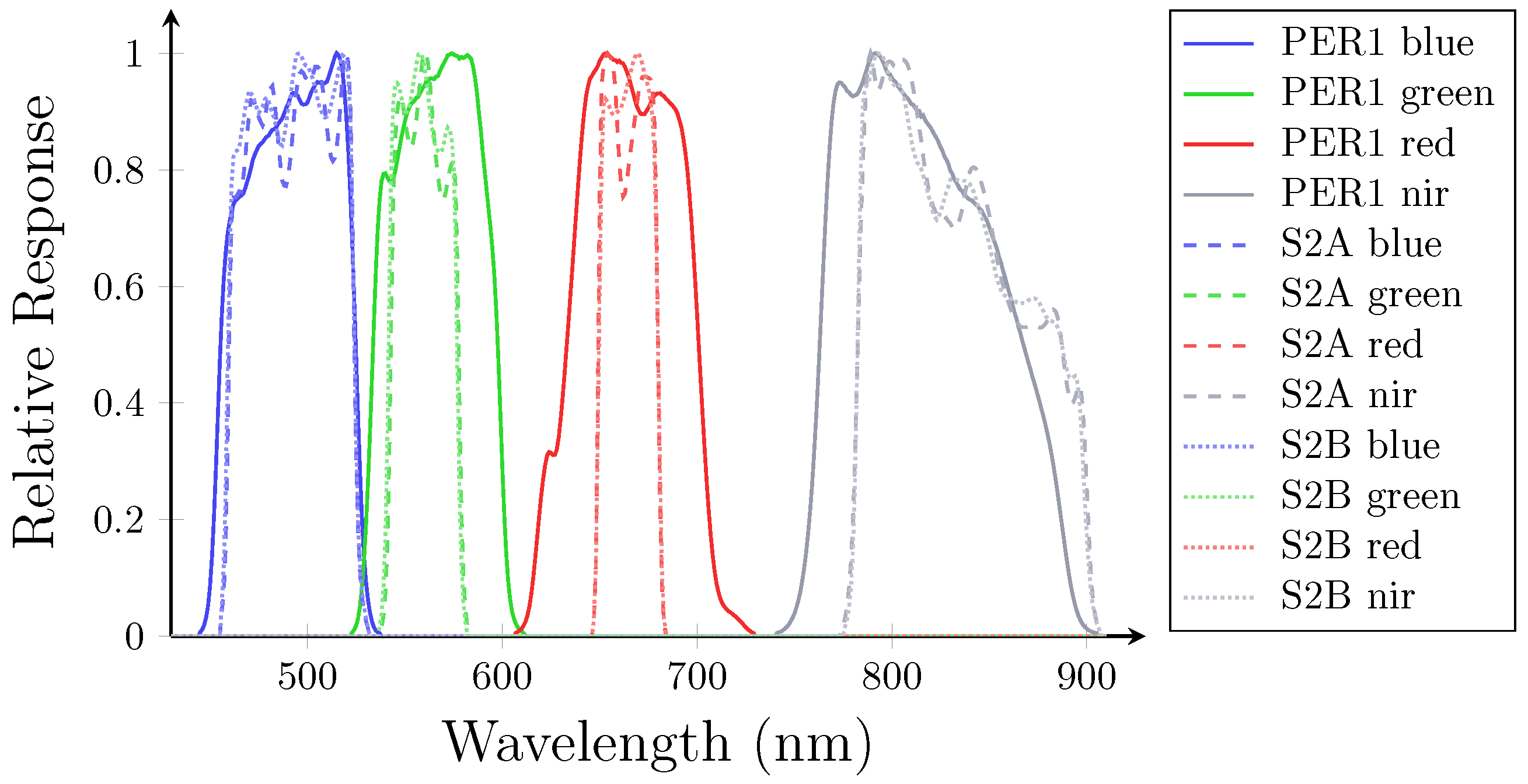
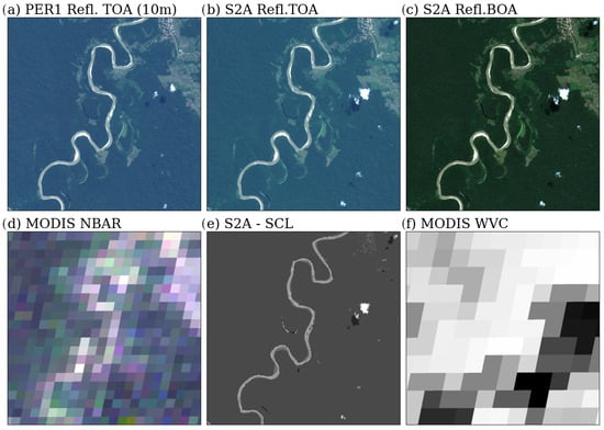
Figure A2.
Composition of some images in a sample set, illustrating spatial alignment.
Figure A2.
Composition of some images in a sample set, illustrating spatial alignment.
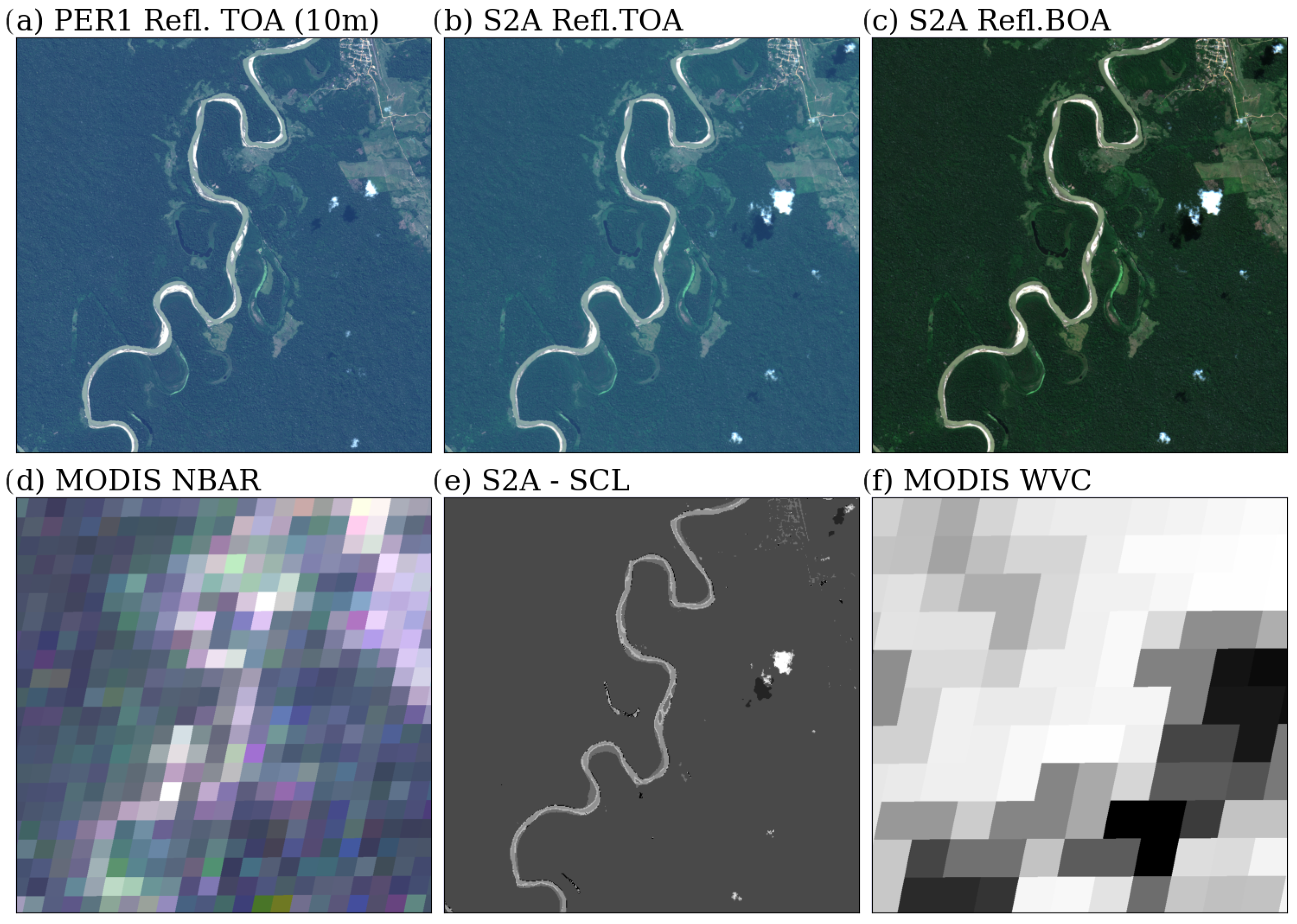
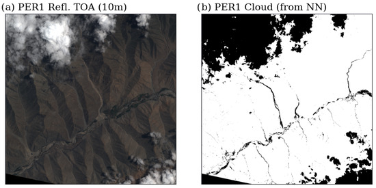
Figure A3.
PER1 cloud classification showing misclassified cloudless dark pixels.
Figure A3.
PER1 cloud classification showing misclassified cloudless dark pixels.
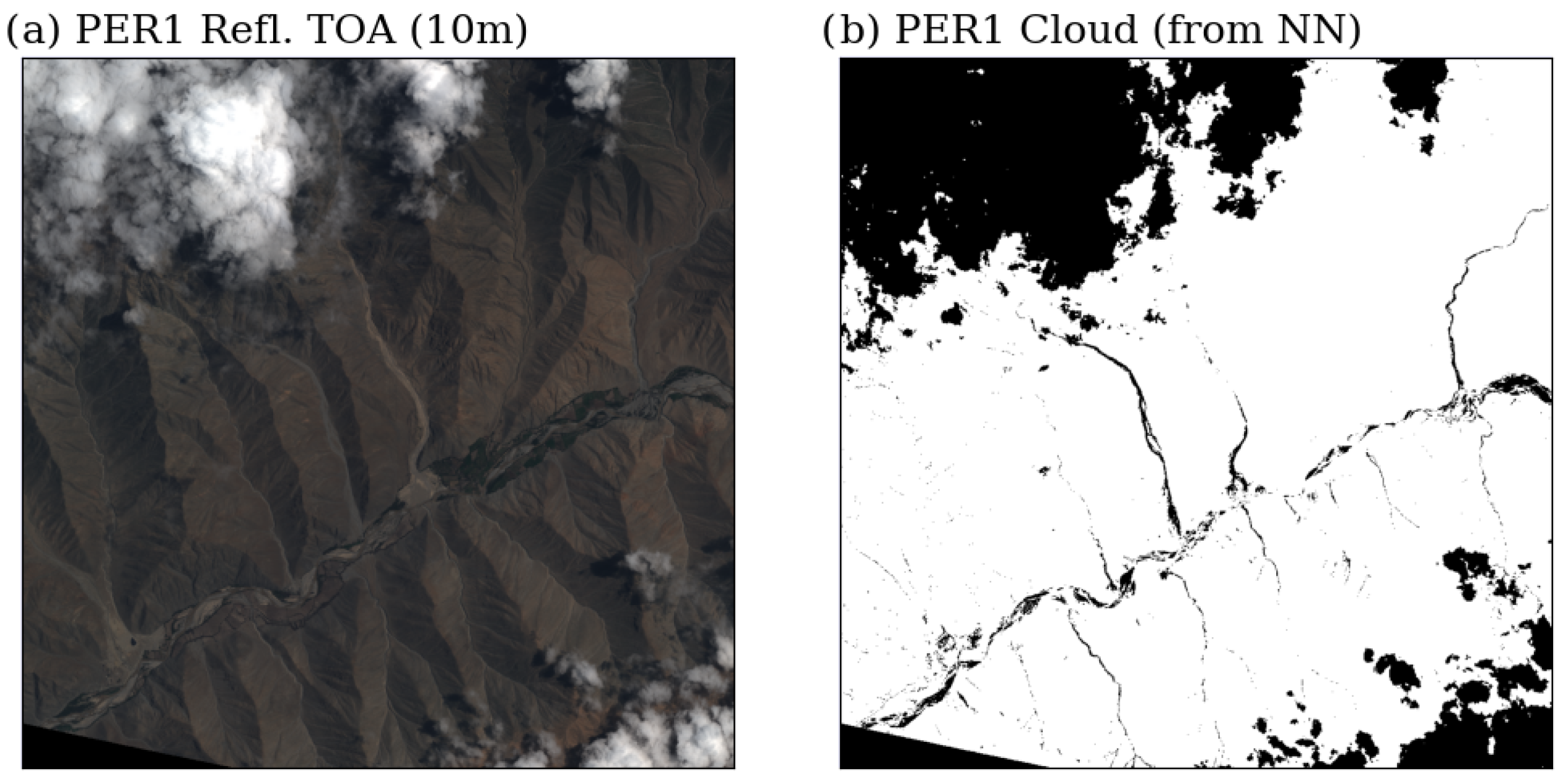
Figure A4.
Pixel-level differences between aligned PER1 and S2 images.
Figure A4.
Pixel-level differences between aligned PER1 and S2 images.
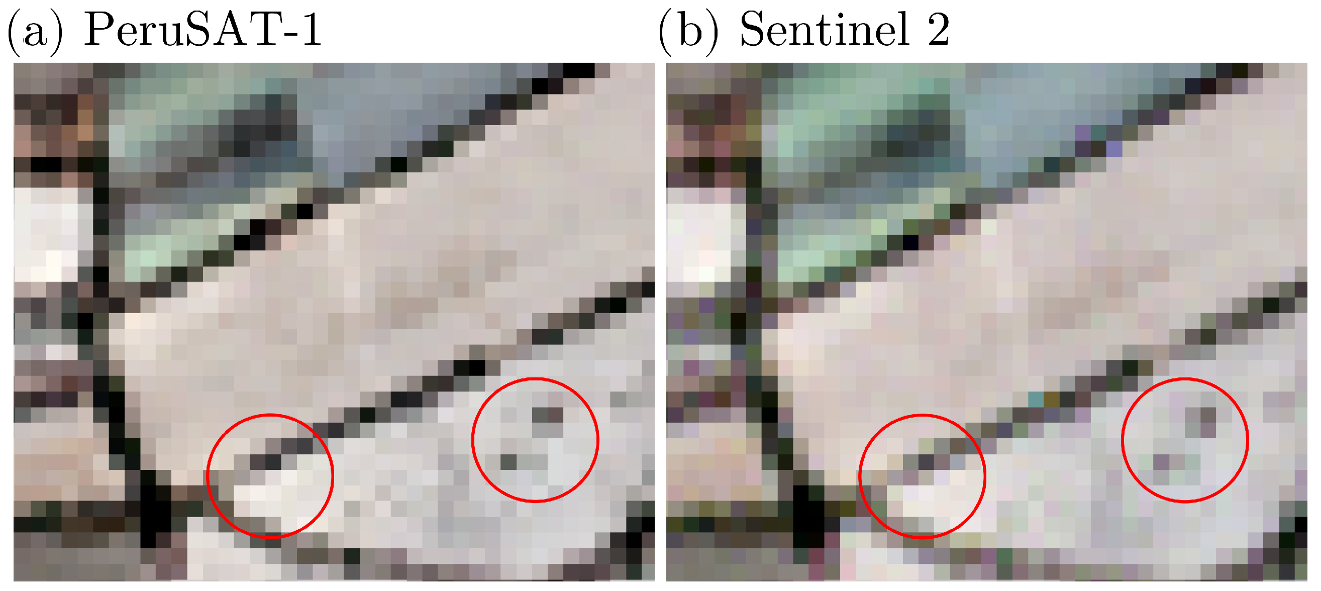
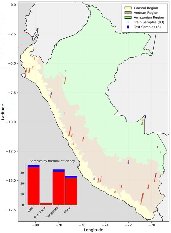
Figure A5.
Location of final sample set sites across Peru.
Figure A5.
Location of final sample set sites across Peru.
Appendix C
Table A2.
Validation results for the best configuration by activation function.
Table A2.
Validation results for the best configuration by activation function.
| Activation Function | Sample | R2 Red | R2 Green | R2 Blue | R2 NIR |
|---|---|---|---|---|---|
| Swish | 20161109151430_B | 0.9646 | 0.9583 | 0.9505 | 0.9819 |
| 20171213145409_C | 0.9778 | 0.9754 | 0.9718 | 0.9750 | |
| 20200718150152_B | 0.7572 | 0.7915 | 0.7400 | 0.9526 | |
| 20210617153211_B | 0.9372 | 0.9336 | 0.9432 | 0.8968 | |
| 20230511154917_H | 0.9311 | 0.9292 | 0.9053 | 0.9114 | |
| Leaky ReLU | 20161109151430_B | 0.9519 | 0.9440 | 0.9431 | 0.9809 |
| 20171213145409_C | 0.9747 | 0.9726 | 0.9546 | 0.9719 | |
| 20200718150152_B | 0.7600 | 0.8708 | 0.7956 | 0.9518 | |
| 20210617153211_B | 0.9357 | 0.9336 | 0.9406 | 0.8965 | |
| 20230511154917_H | 0.9283 | 0.9253 | 0.8976 | 0.8923 | |
| Tanh | 20161109151430_B | 0.9667 | 0.9588 | 0.9499 | 0.9843 |
| 20171213145409_C | 0.9789 | 0.9752 | 0.9731 | 0.9760 | |
| 20200718150152_B | 0.8722 | 0.9087 | 0.8278 | 0.9559 | |
| 20210617153211_B | 0.9401 | 0.9398 | 0.9085 | 0.8987 | |
| 20230511154917_H | 0.9321 | 0.9277 | 0.9058 | 0.9224 |
Appendix D. Algorithmic Frameworks
| Algorithm A1: Geometry extraction for image sample cropping. | |
| 1: Input: (image path), (crop size, default = 3600), GeoTransform (coordinate transformation function) | |
| 2: Output: Shapefiles (SHP) with crop geometry | |
| 3: | ▷ is image matrix; is metadata |
| 4: | ▷ Number of rows (height) |
| 5: | ▷ Number of columns (width) |
| 6: if is not provided then | |
| 7: | ▷ Default crop size |
| 8: end if | |
| 9: | ▷ First row with data |
| 10: function Find_Initial_Row() | |
| 11: for to do | |
| 12: for to 0 do | |
| 13: if then | |
| 14: return y | ▷ Return first non-empty row |
| 15: end if | |
| 16: end for | |
| 17: end for | |
| 18: return H | ▷ Return height if no data is found |
| 19: end function | |
| 20: | ▷ Initial column |
| 21: | ▷ Number of crops |
| 22: for to do | |
| 23: | |
| 24: | |
| 25: | |
| 26: | |
| 27: | |
| 28: | |
| 29: SaveShapeFile(, ) | |
| 30: | ▷ Add separation between crops |
| 31: | |
| 32: end for | |
| 33: return Shapefiles | |
| Algorithm A2: Fixed k-means clustering for consistent classification. | ||
| 1: Input: (PER1 images), k (number of clusters), (excluded classes) | ||
| 2: Output: (binary masks) | ||
| 3: | ▷ Select reference image | |
| 4: | ▷ Compute water index for reference | |
| 5: | ▷ Augment image with water index | |
| 6: | ▷ Normalize augmented image | |
| 7: | ▷ Reshape image data into 2D array | |
| 8: | ▷ Fit k-means to reference image | |
| 9: for each in do | ▷ Iterate over all images | |
| 10: | ▷ Compute water index | |
| 11: | ▷ Augment image with water index | |
| 12: | ▷ Normalize augmented image | |
| 13: | ▷ Reshape image data into 2D array | |
| 14: | ▷ Predict clusters | |
| 15: for to do | ▷ Iterate over all pixels | |
| 16: | ▷ Create binary mask | |
| 17: end for | ||
| 18: end for | ||
| 19: return | ▷ Return binary masks for all images | |
| Algorithm A3: Contextual iterative data cleaning. | |
| 1: Input: (dataset), PER1 (target), S2 (slave), (Pearson correlation (PC) thresholds list), (initial threshold), (threshold step), (target PC values) | |
| 2: Output: (cleaned dataset), (linear coefficients) | |
| 3: | ▷ Filter invalid rows (e.g., NaNs, zeros) |
| 4: for do | ▷ Iterate over PC thresholds |
| 5: | |
| 6: for do | |
| 7: | |
| 8: | |
| 9: | ▷ Mean and covariance for m |
| 10: | |
| 11: while and do | |
| 12: | ▷ Mahalanobis distance |
| 13: | |
| 14: | ▷ Calculate PC |
| 15: if then | |
| 16: | |
| 17: break | |
| 18: else | |
| 19: | |
| 20: | |
| 21: end if | |
| 22: end while | |
| 23: if then | |
| 24: | |
| 25: end if | |
| 26: end for | |
| 27: | |
| 28: end for | |
| 29: return , | ▷ Return cleaned dataset and coefficients |
References
- Vaughan, R.A.; Jones, H.G. Remote Sensing of Vegetation: Principles, Techniques and Applications, 1st ed.; Oxford University Press: Oxford, UK, 2010. [Google Scholar]
- Campbell, J.B.; Wynne, R.H. Introduction to Remote Sensing, 5th ed.; Guilford Press: New York, NY, USA, 2011. [Google Scholar]
- Kaufman, Y.J. Atmospheric effect on spatial resolution of surface imagery. Appl. Opt. 1984, 23, 4164–4172. [Google Scholar] [CrossRef] [PubMed]
- Rech, B.; Hess, J.H. Effects of Atmospheric Correction on NDVI Retrieved From Sentinel 2 Imagery over Different Land Classes. Braz. Symp. Remote Sens. 2023, 20, 968–971. [Google Scholar]
- Wang, D.; Xiang, X.; Ma, R.; Guo, Y.; Zhu, W.; Wu, Z. A Novel Atmospheric Correction for Turbid Water Remote Sensing. Remote Sens. 2023, 15, 2091. [Google Scholar] [CrossRef]
- Zhou, Q.; Wang, S.; Liu, N.; Townsend, P.A.; Jiang, C.; Peng, B.; Verhoef, W.; Guan, K. Towards operational atmospheric correction of airborne hyperspectral imaging spectroscopy: Algorithm evaluation, key parameter analysis, and machine learning emulators. ISPRS J. Photogramm. Remote Sens. 2023, 196, 386–401. [Google Scholar] [CrossRef]
- Berk, A.; Conforti, P.; Kennett, R.; Perkins, T.; Hawes, F.; Van Den Bosch, J. MODTRAN® 6: A major upgrade of the MODTRAN® radiative transfer code. In Proceedings of the 2014 6th Workshop on Hyperspectral Image and Signal Processing: Evolution in Remote Sensing (WHISPERS), Lausanne, Switzerland, 24–27 June 2014; IEEE: Piscataway, NJ, USA, 2014; pp. 1–4. [Google Scholar] [CrossRef]
- Vermote, E.; Tanre, D.; Deuze, J.; Herman, M.; Morcette, J.J. Second Simulation of the Satellite Signal in the Solar Spectrum, 6S: An overview. IEEE Trans. Geosci. Remote Sens. 1997, 35, 675–686. [Google Scholar] [CrossRef]
- Chavez, P.S. An improved dark-object subtraction technique for atmospheric scattering correction of multispectral data. Remote Sens. Environ. 1988, 24, 459–479. [Google Scholar] [CrossRef]
- Bernstein, L.S. Quick atmospheric correction code: Algorithm description and recent upgrades. Opt. Eng. 2012, 51, 111719. [Google Scholar] [CrossRef]
- Gao, B.C.; Montes, M.J.; Davis, C.O.; Goetz, A.F. Atmospheric correction algorithms for hyperspectral remote sensing data of land and ocean. Remote Sens. Environ. 2009, 113, S17–S24. [Google Scholar] [CrossRef]
- Boardman, J.W. Post-ATREM polishing of AVIRIS apparent reflectance data using EFFORT: A lesson in accuracy versus precision. In Proceedings of the Summaries of the Seventh JPL Airborne Earth Science Workshop, Pasadena, CA, USA, 12–16 January 1998; Jet Propulsion Laboratory: Pasadena, CA, USA, 1998; Volume 1, p. 53. [Google Scholar]
- Pereira-Sandoval, M.; Ruescas, A.; Urrego, P.; Ruiz-Verdú, A.; Delegido, J.; Tenjo, C.; Soria-Perpinyà, X.; Vicente, E.; Soria, J.; Moreno, J. Evaluation of Atmospheric Correction Algorithms over Spanish Inland Waters for Sentinel-2 Multi Spectral Imagery Data. Remote Sens. 2019, 11, 1469. [Google Scholar] [CrossRef]
- Plotnikov, D.; Kolbudaev, P.; Matveev, A.; Proshin, A.; Polyanskiy, I. Accuracy Assessment of Atmospheric Correction of KMSS-2 Meteor-M #2.2 Data over Northern Eurasia. Remote Sens. 2023, 15, 4395. [Google Scholar] [CrossRef]
- Doxani, G.; Vermote, E.; Roger, J.C.; Gascon, F.; Adriaensen, S.; Frantz, D.; Hagolle, O.; Hollstein, A.; Kirches, G.; Li, F.; et al. Atmospheric Correction Inter-Comparison Exercise. Remote Sens. 2018, 10, 352. [Google Scholar] [CrossRef] [PubMed]
- Doxani, G.; Vermote, E.F.; Roger, J.C.; Skakun, S.; Gascon, F.; Collison, A.; De Keukelaere, L.; Desjardins, C.; Frantz, D.; Hagolle, O.; et al. Atmospheric Correction Inter-comparison eXercise, ACIX-II Land: An assessment of atmospheric correction processors for Landsat 8 and Sentinel-2 over land. Remote Sens. Environ. 2023, 285, 113412. [Google Scholar] [CrossRef]
- Badhan, M.; Shamsaei, K.; Ebrahimian, H.; Bebis, G.; Lareau, N.P.; Rowell, E. Deep Learning Approach to Improve Spatial Resolution of GOES-17 Wildfire Boundaries Using VIIRS Satellite Data. Remote Sens. 2024, 16, 715. [Google Scholar] [CrossRef]
- Yuan, S.; Zhu, S.; Luo, X.; Mu, B. A deep learning-based bias correction model for Arctic sea ice concentration towards MITgcm. Ocean. Model. 2024, 188, 102326. [Google Scholar] [CrossRef]
- Zhang, W.; Sun, Y.; Wu, Y.; Dong, J.; Song, X.; Gao, Z.; Pang, R.; Guoan, B. A deep-learning real-time bias correction method for significant wave height forecasts in the Western North Pacific. Ocean Model. 2024, 187, 102289. [Google Scholar] [CrossRef]
- Shah, M.; Raval, M. A Deep Learning Model for Atmospheric Correction of Satellite Images. Authorea Prepr. 2022. [Google Scholar] [CrossRef]
- Shah, M.; Raval, M.S.; Divakaran, S. A Deep Learning Perspective to Atmospheric Correction of Satellite Images. In Proceedings of the IGARSS 2022—2022 IEEE International Geoscience and Remote Sensing Symposium, Kuala Lumpur, Malaysia, 17–22 July 2022; IEEE: Piscataway, NJ, USA, 2022; pp. 346–349. [Google Scholar] [CrossRef]
- Basener, A.A.; Basener, B.B. Deep Learning of Radiative Atmospheric Transfer with an Autoencoder. In Proceedings of the 2022 12th Workshop on Hyperspectral Imaging and Signal Processing: Evolution in Remote Sensing (WHISPERS), Rome, Italy, 13–16 September 2022; IEEE: Piscataway, NJ, USA, 2022; pp. 1–7. [Google Scholar] [CrossRef]
- Men, J.; Tian, L.; Zhao, D.; Wei, J.; Feng, L. Development of a Deep Learning-Based Atmospheric Correction Algorithm for Oligotrophic Oceans. IEEE Trans. Geosci. Remote Sens. 2022, 60, 4210819. [Google Scholar] [CrossRef]
- Zhao, X.; Ma, Y.; Xiao, Y.; Liu, J.; Ding, J.; Ye, X.; Liu, R. Atmospheric correction algorithm based on deep learning with spatial-spectral feature constraints for broadband optical satellites: Examples from the HY-1C Coastal Zone Imager. ISPRS J. Photogramm. Remote Sens. 2023, 205, 147–162. [Google Scholar] [CrossRef]
- Hosain, M.T.; Jim, J.R.; Mridha, M.; Kabir, M.M. Explainable AI approaches in deep learning: Advancements, applications and challenges. Comput. Electr. Eng. 2024, 117, 109246. [Google Scholar] [CrossRef]
- Haider, S.N.; Zhao, Q.; Meran, B.K. Automated data cleaning for data centers: A case study. In Proceedings of the 2020 39th Chinese Control Conference (CCC), Shenyang, China, 27–29 July 2020; IEEE: Piscataway, NJ, USA, 2020; pp. 3227–3232. [Google Scholar] [CrossRef]
- Shah, M.; Raval, M.; Divakaran, S.; Patel, P. Study and Impact Analysis of Data Shift in Deep Learning Based Atmospheric Correction. In Proceedings of the IGARSS 2023—2023 IEEE International Geoscience and Remote Sensing Symposium, Pasadena, CA, USA, 16–21 July 2023; IEEE: Piscataway, NJ, USA, 2023; pp. 6728–6731. [Google Scholar] [CrossRef]
- SENAMHI. Climas del Perú: Resumen Ejecutivo [Climates of Peru: Executive Summary]; Government Report; Servicio Nacional de Meteorología e Hidrología del Perú (SENAMHI): Lima, Peru, 2023.
- McCoy, R.M. Field Methods in Remote Sensing; Guilford Press: New York, NY, USA, 2005. [Google Scholar]
- eoPortal Directory. PeruSAT-1 Earth Observation Minisatellite. Satellite Missions Catalogue. 2016. Available online: https://www.eoportal.org/satellite-missions/perusat-1#naomi-new-astrosat-optical-modular-instrument (accessed on 22 August 2024).
- Main-Knorn, M.; Pflug, B.; Louis, J.; Debaecker, V.; Müller-Wilm, U.; Gascon, F. Sen2Cor for Sentinel-2. In Image and Signal Processing for Remote Sensing XXIII, Proceedings of the SPIE Remote Sensing, Warsaw, Poland, 1–14 September 2017; Bruzzone, L., Bovolo, F., Benediktsson, J.A., Eds.; SPIE: Bellingham, WA, USA, 2017; p. 3. [Google Scholar] [CrossRef]
- Pignatale, F. Sen2Cor 2.11.00 Configuration and User Manual; ACRI-ST: Sophia-Antipolis, France, 2022; OMPC.TPZG.SUM.001. [Google Scholar]
- Louis, J.; Devignot, O.; Pessiot, L. Sen2like L2HF Product Definition Document 2022-1.1; Technical Report; European Space Agency (ESA): Paris, France, 2022. [Google Scholar]
- Clerc, S. MPC Team ARGANS. Level 2A Data Quality Report; Technical Report; European Space Agency (ESA): Paris, France, 2022; Issue 2.0, S2-PDGS-MPC-S2L-ATBD. [Google Scholar]
- European Space Agency (ESA). Sentinel-2 Harmonized Level-1C (L1C) Dataset. 2024. Available online: https://developers.google.com/earth-engine/datasets/catalog/COPERNICUS_S2_HARMONIZED#description (accessed on 19 January 2024).
- European Space Agency (ESA). Sentinel-2 Harmonized Level-2A (L2A) Dataset. 2024. Available online: https://developers.google.com/earth-engine/datasets/catalog/COPERNICUS_S2_SR_HARMONIZED#description (accessed on 19 January 2024).
- Louis, J.; Devignot, O.; Pessiot, L. Sen2like Algorithm Theoretical Basis Document 2022-2.0; Technical Report; European Space Agency (ESA): Paris, France, 2022; Issue 2.0, S2-PDGS-MPC-S2L-ATBD. [Google Scholar]
- Sabater, M.M. Development of Atmospheric Correction Algorithms for Very High Spectral and Spatial Resolution Images: Application to SEOSAT and the FLEX/Sentinel-3 Missions. Ph.D. Thesis, Universitat de València, Valencia, Spain, 2018. [Google Scholar]
- Lacherade, S.; Fougnie, B.; Henry, P.; Gamet, P. Cross Calibration Over Desert Sites: Description, Methodology, and Operational Implementation. IEEE Trans. Geosci. Remote Sens. 2013, 51, 1098–1113. [Google Scholar] [CrossRef]
- Mather, P.; Tso, B. Classification Methods for Remotely Sensed Data, 2nd ed.; CRC Press: Boca Raton, FL, USA, 2009. [Google Scholar] [CrossRef]
- Tong, X.; Ye, Z.; Xu, Y.; Gao, S.; Xie, H.; Du, Q.; Liu, S.; Xu, X.; Liu, S.; Luan, K.; et al. Image Registration with Fourier-Based Image Correlation: A Comprehensive Review of Developments and Applications. IEEE J. Sel. Top. Appl. Earth Obs. Remote Sens. 2019, 12, 4062–4081. [Google Scholar] [CrossRef]
- Alipour-Langouri, M.; Zheng, Z.; Chiang, F.; Golab, L.; Szlichta, J. Contextual Data Cleaning. In Proceedings of the 2018 IEEE 34th International Conference on Data Engineering Workshops (ICDEW), Paris, France, 16–20 April 2018; IEEE: Piscataway, NJ, USA, 2018; pp. 21–24. [Google Scholar] [CrossRef]
- Cabana, E.; Lillo, R.E.; Laniado, H. Multivariate outlier detection based on a robust Mahalanobis distance with shrinkage estimators. Stat. Pap. 2021, 62, 1583–1609. [Google Scholar] [CrossRef]
- Ramachandran, P.; Zoph, B.; Le, Q.V. Searching for Activation Functions. arXiv 2017, arXiv:1710.05941. [Google Scholar]
- Glorot, X.; Bengio, Y. Understanding the difficulty of training deep feedforward neural networks. In Proceedings of the Thirteenth International Conference on Artificial Intelligence and Statistics, Sardinia, Italy, 13–15 May 2010; Volume 9, pp. 249–256. [Google Scholar]
- Nwankpa, C.; Ijomah, W.; Gachagan, A.; Marshall, S. Activation Functions: Comparison of trends in Practice and Research for Deep Learning. arXiv 2018, arXiv:1811.03378. [Google Scholar] [CrossRef]
- Srivastava, N.; Hinton, G.; Krizhevsky, A.; Sutskever, I.; Salakhutdinov, R. Dropout: A Simple Way to Prevent Neural Networks from Overfitting. J. Mach. Learn. Res. 2014, 15, 1929–1958. [Google Scholar]
- Montavon, G.; Orr, G.B.; Müller, K.R. (Eds.) Neural Networks: Tricks of the Trade, 2nd ed.; Lecture Notes in Computer Science; Springer: Berlin/Heidelberg, Germany, 2012; Volume 7700. [Google Scholar] [CrossRef]
- Ioffe, S.; Szegedy, C. Batch Normalization: Accelerating Deep Network Training by Reducing Internal Covariate Shift. arXiv 2015, arXiv:1502.03167. [Google Scholar]
- Emmert-Streib, F.; Yang, Z.; Feng, H.; Tripathi, S.; Dehmer, M. An Introductory Review of Deep Learning for Prediction Models with Big Data. Front. Artif. Intell. 2020, 3, 4. [Google Scholar] [CrossRef]
- Emmert-Streib, F.; Dehmer, M. (Eds.) Deep Learning Models; MDPI: Basel, Switzerland, 2020. [Google Scholar]
- Bengio, Y. Learning Deep Architectures for AI. Found. Trends Mach. Learn. 2009, 2, 1–127. [Google Scholar] [CrossRef]
Disclaimer/Publisher’s Note: The statements, opinions and data contained in all publications are solely those of the individual author(s) and contributor(s) and not of MDPI and/or the editor(s). MDPI and/or the editor(s) disclaim responsibility for any injury to people or property resulting from any ideas, methods, instructions or products referred to in the content. |
© 2025 by the authors. Licensee MDPI, Basel, Switzerland. This article is an open access article distributed under the terms and conditions of the Creative Commons Attribution (CC BY) license (https://creativecommons.org/licenses/by/4.0/).