Selecting the Optimal Approach for Individual Tree Segmentation in Euphrates Poplar Desert Riparian Forest Using Terrestrial Laser Scanning
Highlights
- We benchmark six tree segmentation algorithms on TLS data from 507 P. euphratica trees and identify two approaches—deep-learning trunk extraction and leaf–wood separation—as the reliable methods.
- Field validation demonstrates that these two methods accurately extract tree crown structure, enabling a rapid, plot-scale inventory of the desert riparian forests.
- Managers use TLS with trunk-based or leaf–wood-separation pipelines to quickly create accurate tree lists in P. euphratica stands. This approach not only directly im-proves biomass and carbon measurements, health checks, and restoration monitor-ing, but also reduces manual effort.
- Furthermore, trunk-based or leaf–wood-separation-based approaches outperform crown height model methods in clustered, overlapping crowns. This offers clear guidance for an algorithm that can be applied to similar arid riparian forests.
Abstract
1. Introduction
2. Materials and Methods
2.1. Site Characteristics and Data Collection
2.2. Tree Segmentation Methods
- (a)
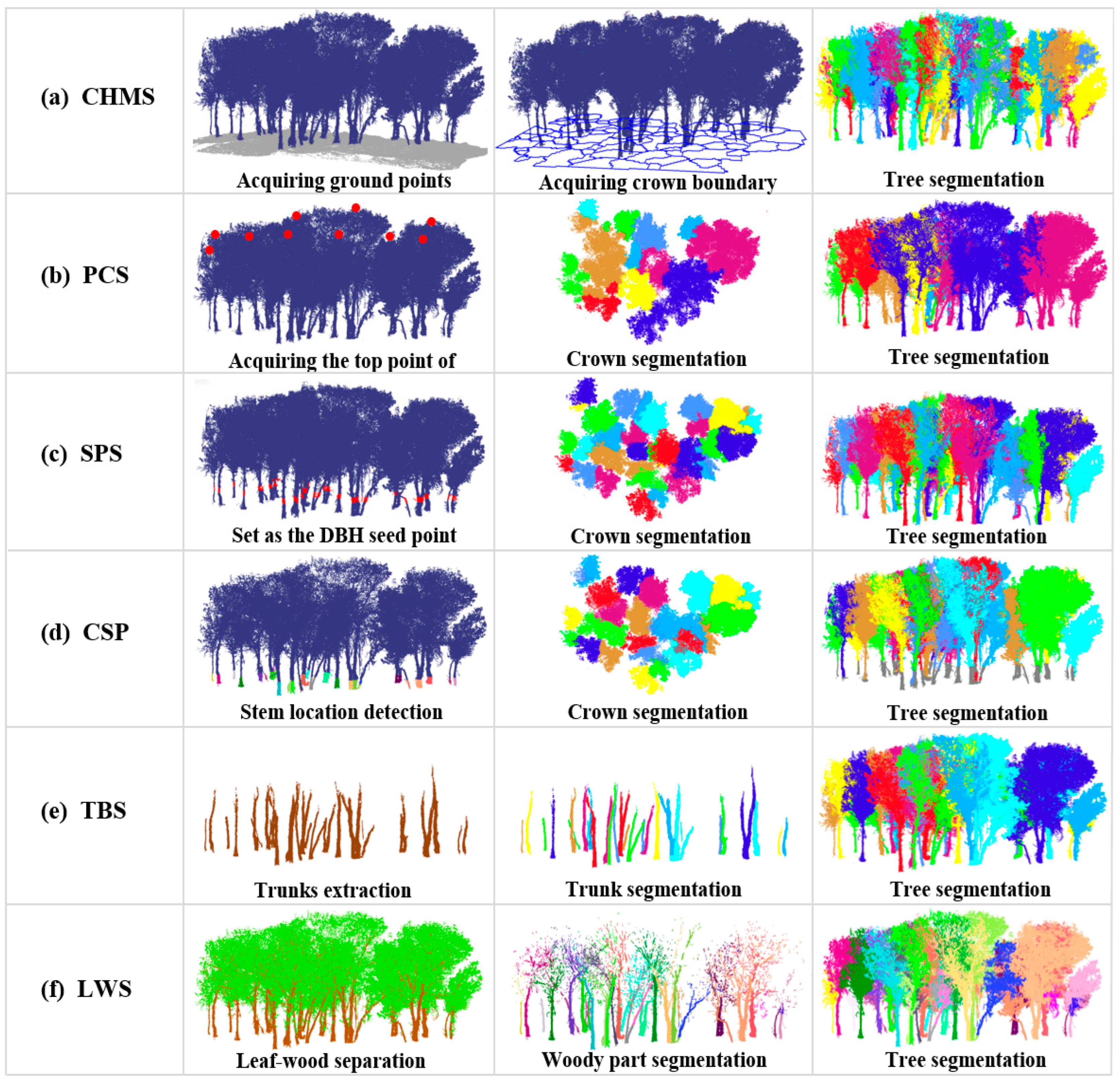
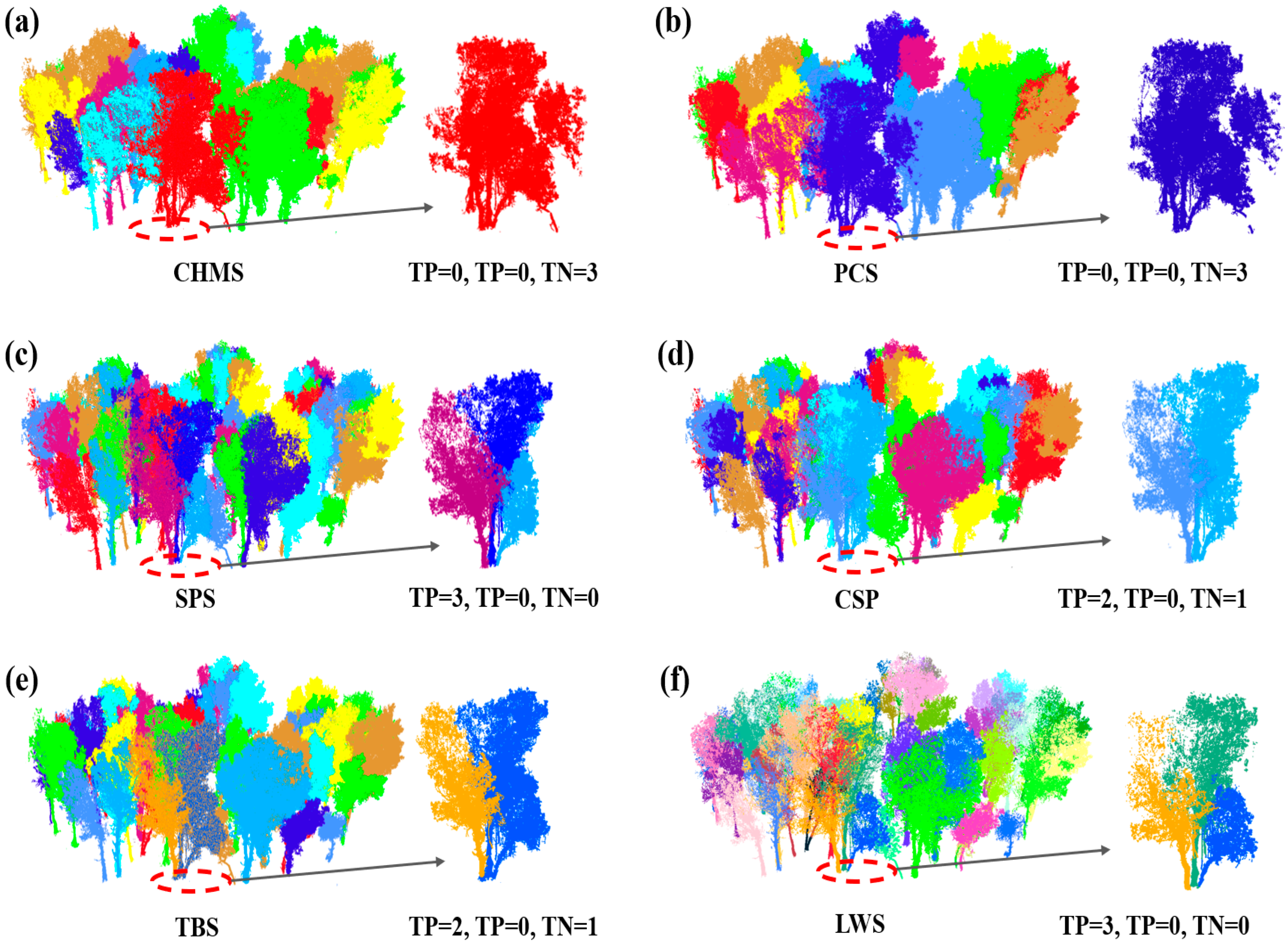
- CHMS method: Typically, trees are identified from Canopy Height Models (CHMs), which are made by creating a surface of the forest canopy from the tallest detected points, and, if possible, adjusting for ground height using a terrain map. For example, Hyyppa et al. [45] used a region-growing technique to identify individual conifer trees in CHMs. In our approach, the CHM was generated following a series of standardized steps. First, the pre-processed point clouds were filtered to separate ground and vegetation points. A digital elevation model (DEM) with a 0.5 m spatial resolution was constructed from ground points, while a corresponding 0.5 m digital surface model (DSM) was derived from the combined vegetation and ground points. The CHM was then obtained by subtracting the DEM from the DSM. To delineate individual tree crowns, we applied a watershed segmentation method [46], which treats local maxima in the CHM as “peaks” and local minima as “valleys”. When simulating the process of water accumulation, adjacent valleys may merge; therefore, watershed lines are imposed to prevent merging and to define crown boundaries. Based on the height characteristics of young P. euphratica, we defined a minimum tree height of 1.5 m for detectable individuals, and initiated crown delineation only above a 1 m height threshold to avoid segmenting low vegetation or ground artefacts (Figure 4a).
- (b)
- PCS method: Li et al. [33] developed a top-down region-growing point-cloud segmentation (PCS) approach for complex mixed forests. The method assumes the presence of inter-tree gaps and uses a gap or spacing threshold to prevent crown merging. Implementation proceeds in several steps: first, the highest unassigned point (canopy apex) is selected as a seed; next, a candidate crown is grown by adding neighboring points that meet distance and height-continuity criteria; crown growth stops when the gap to surrounding points exceeds the spacing threshold; the segmented crown is then removed; and finally, the process repeats from the next highest unassigned apex. Throughout, distances between the current crown and unassigned points are evaluated iteratively to decide membership, enabling step-by-step individual-tree segmentation (Figure 4b).
- (c)
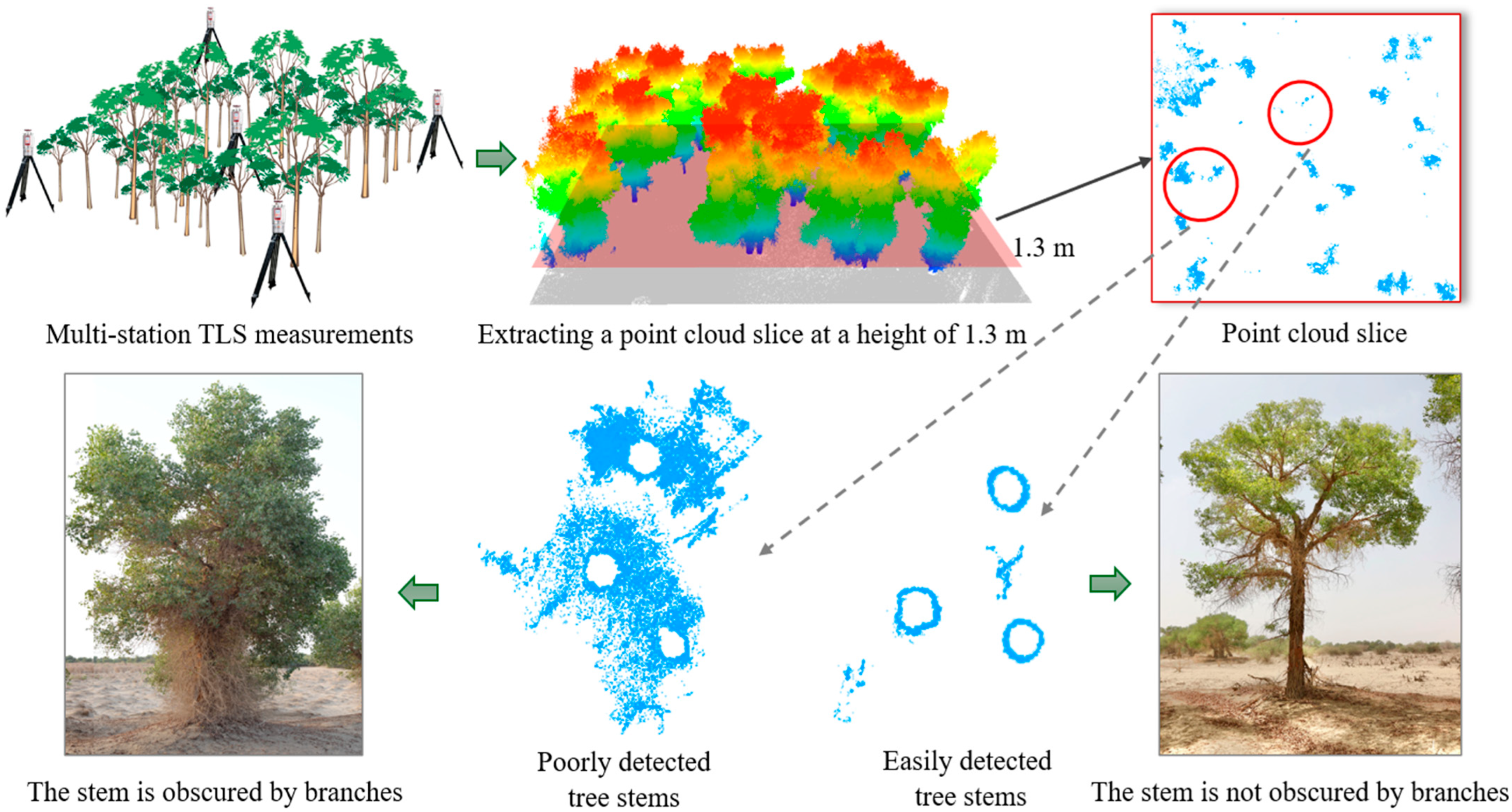
- SPS method: Seed-point segmentation (SPS) generates seeds at breast height. Heights are first normalized to the ground (Figure 4c). A thin horizontal slice at 1.3 m is then extracted. Stem cross-sections are detected using the circular Hough transform [47]. For each detected stem, the center of the circle defines the seed location. The estimated radius initializes the neighborhood. Using the 3D coordinates of these seeds, points within the DBH-based radius—or the nearest point if the slice is sparse—are assigned as the initial seed cluster. This cluster is subsequently grown to delineate the full individual tree. The algorithm searches for points within the DBH-based radius—or the nearest available points when the slice is sparse—around the 3D seed coordinates to form the initial seed-point cluster for subsequent segmentation. In our approach, a clustering threshold of 0.2 m was applied for segmentation.
- (d)
- CSP method: Tao et al. [37] developed the Comparative Short Past (CSP) algorithm to segment tree crowns using terrestrial LiDAR data. CSP runs in two stages. First, it localizes stems using near-ground slices to detect axes. Second, it assigns crowns by comparing the shortest geodesic paths from each stem base or axis to candidate canopy points or voxels. The method is based on metabolic ecology and vascular transport theory. Crown elements of the same tree minimize their transport path length to the stem. Each point is assigned to the stem with the lowest normalized path cost, resulting in individual crown partitions (Figure 4). In this study, the CSP algorithm was implemented with the following parameter settings. A clustering threshold of 0.2 m was applied when aggregating points around detected stem axes. Each stem cluster was required to contain at least 500 points to be retained as a valid stem. The stem-detection slice height was set to 1 m to ensure reliable localization of the main stem structure near the ground. Consistent with the other segmentation methods, a minimum tree height of 1.5 m was imposed to exclude low shrubs and non-tree objects from subsequent crown assignment.
- (e)
- TBS method: This approach has two stages: trunk extraction and crown segmentation. First, trunks are detected in the point cloud using a deep-learning model [48]. Following López-Serrano et al. [48], the normalized point cloud is converted into a series of 2-D raster slices at predefined heights (typically every 0.10–0.20 m, with a ground-plane resolution of 1 cm). Each slice is treated as an input image for a Faster R-CNN detector with an Inception-V2 backbone, trained on manually annotated stem-section datasets sampled from multiple forest plots with diverse stand structures. The training dataset contains thousands of labelled cross-sections (≈5000 for training and ≈1200 for validation), allowing the model to generalize across species, stem forms, and understory conditions. During inference, detections were filtered using a 0.6 confidence threshold and linked vertically based on ≥70% planimetric overlap to reconstruct continuous trunk axes. These reconstructed trunk axes serve as spatial seeds and constraints for crown delineation. Neighboring canopy points are iteratively assigned to the nearest trunk based on 3-D proximity and vertical continuity, allowing each crown to expand outward from its stem and ultimately producing individual-tree segments (Figure 4).
- (f)
- LWS method: Wang et al. [49] developed a leaf–wood segmentation algorithm known as LeWoS. This method recursively partitions the point cloud into small, near-pure clusters using a proximity–normal-verticality graph. It assigns each cluster a leaf/wood probability based on linearity and cluster-size cues, which are evaluated over a grid of decision thresholds. The method was evaluated using a comprehensive dataset of 61 large tropical trees spanning 15 species, ranging from 20,000 to 10 million points per tree, each accompanied by manually labeled leaf–wood references for validation. The algorithm requires only a single tunable parameter—Nz_thres, which defines the permissible difference in point-wise verticality between neighbors during recursive graph segmentation. Sensitivity analysis demonstrated that Nz_thres values between 0.125–0.15 provide the highest point-wise classification accuracy (≈0.91); therefore, in this study, Nz_thres = 0.15 was adopted as the default setting in the original implementation.
2.3. Accuracy Assessment of Segmentation
2.4. Field Measurements
3. Results
4. Discussion
5. Conclusions
Author Contributions
Funding
Data Availability Statement
Acknowledgments
Conflicts of Interest
Abbreviations
| CHMS | Canopy height model-based segmentation |
| PCS | Crown top point cloud segmentation |
| CSP | Comparative short path algorithm segmentation |
| TBS | Deep learning trunk extraction-based segmentation |
| LWS | Leaf–wood separation-based segmentation |
References
- Wang, S.; Chen, B.; Li, H. Euphrates Poplar Forest, 1st ed.; Zhang, X., Ed.; China Environmental Science Press: Beijing, China, 1995; pp. 19–30. [Google Scholar]
- Buras, A.; Thevs, N.; Zerbe, S.; Wilmking, M. Productivity and carbon sequestration of Populus euphratica at the Amu River, Turkmenistan. Forestry 2013, 86, 429–439. [Google Scholar] [CrossRef][Green Version]
- Thomas, F.; Lang, P. Growth and water relations of riparian poplar forests under pressure in Central Asia’s Tarim River Basin. River Res. Appl. 2021, 37, 233–240. [Google Scholar] [CrossRef]
- Li, J.; Yu, B.; Zhao, C.; Nowak, R.S.; Zhao, Z.; Sheng, Y.; Li, J. Physiological and morphological responses of Tamarix ramosissima and Populus euphratica to altered groundwater availability. Tree Physiol. 2013, 33, 57–68. [Google Scholar] [CrossRef]
- Gärtner, P.; Foerster, M.; Kleinschmit, B. The benefit of synthetically generated RapidEye and Landsat 8 data fusion time series for riparian forest disturbance monitoring. Remote Sens. Environ. 2016, 177, 237–247. [Google Scholar] [CrossRef]
- Halik, Ü.; Aishan, T.; Betz, F.; Kurban, A.; Rozi, A. Effectiveness and challenges of ecological engineering for desert riparian forest restoration along China’s largest inland river. Ecol. Eng. 2018, 127, 11–22. [Google Scholar] [CrossRef]
- Keram, A.; Halik, Ü.; Keyimu, M.; Aishan, T.; Mamat, Z.; Rouzi, A. Gap Dynamics of Natural Populus euphratica Floodplain Forests Affected by Hydrological Alteration Along the Tarim River: Implications for Restoration of the Riparian Forests. For. Ecol. Manag. 2019, 438, 103–113. [Google Scholar] [CrossRef]
- Arkin, A.; Yusup, A.; Halik, Ü.; Abliz, A.; Ainiwaer, A.; Tian, A.; Mijiti, M. Unveiling population structure dynamics of Populus euphratica riparian forests along the Tarim River using terrestrial LiDAR. Forests 2025, 16, 368. [Google Scholar] [CrossRef]
- Keyimu, M.; Halik, Ü.; Betz, F.; Dulamsuren, C. Vitality variation and population structure of a riparian forest in the lower reaches of the Tarim River, NW China. J. For. Res. 2017, 29, 749–760. [Google Scholar] [CrossRef]
- Wei, Z.C.; Halik, Ü.; Aishan, T.; Abliz, A.; Welp, M. Spatial distribution patterns of trunk internal decay of Euphrates poplar riparian forest along the Tarim River, northwest China. For. Ecol. Manag. 2022, 522, 120434. [Google Scholar] [CrossRef]
- Peng, Y.; He, G.J.; Wang, G.Z. Spatial–temporal analysis of changes in Populus euphratica distribution in the Tarim National Nature Reserve over the past 60 years. Int. J. Appl. Earth Obs. Geoinf. 2022, 113, 103000. [Google Scholar] [CrossRef]
- Gärtner, P.; Förster, M.; Kurban, A.; Kleinschmit, B. Object-based change detection of Central Asian Tugai vegetation with very high spatial resolution satellite imagery. Int. J. Appl. Earth Obs. Geoinf. 2014, 31, 110–121. [Google Scholar] [CrossRef]
- Ling, H.B.; Zhang, P.; Guo, B.; Xu, H.L.; Ye, M.; Deng, X.Y. Negative feedback adjustment challenges reconstruction study from tree rings: A case study of the response of Populus euphratica to river discontinuous flow and ecological water conveyance. Sci. Total Environ. 2017, 574, 109–119. [Google Scholar] [CrossRef]
- Liu, Q.; Ma, W.; Zhang, J.; Liu, Y.; Xu, D.; Wang, J. Point-cloud segmentation of individual trees in complex natural forest scenes based on a trunk-growth method. J. For. Res. 2021, 32, 2403–2414. [Google Scholar] [CrossRef]
- Wang, D. Unsupervised semantic and instance segmentation of forest point clouds. ISPRS J. Photogramm. Remote Sens. 2020, 165, 86–97. [Google Scholar] [CrossRef]
- Cherlet, W.; Dayal, K.; Chen, S.; Cooper, Z.; Disney, M.; Hanzl, A.; Levick, S.; Nightingale, J.; Origo, N.; Senf, C.; et al. Benchmarking tree instance segmentation of terrestrial laser scanning point clouds. ISPRS J. Photogramm. Remote Sens. 2026, 231, 230–247. [Google Scholar] [CrossRef]
- Mamat, Z.; Halik, Ü.; Keyimu, M.; Keram, A.; Nurmamat, K. Variation of the floodplain forest ecosystem service value in the lower reaches of the Tarim River, China. Land. Degrad. Dev. 2017, 29, 47–57. [Google Scholar] [CrossRef]
- Li, H.; Shi, Q.D.; Wan, Y.B.; Shi, H.B.; Imin, B. Using Sentinel-2 images to map the Populus euphratica distribution based on the spectral difference acquired at the key phenological stage. Forests 2021, 12, 147. [Google Scholar] [CrossRef]
- Ayrey, E.; Fraver, S.; Kershaw, J.; Kenefic, L.; Hayes, D.; Weiskittel, A.; Roth, B. Layer stacking: A novel algorithm for individual forest tree segmentation from LiDAR point clouds. Can. J. Remote Sens. 2017, 43, 16–27. [Google Scholar] [CrossRef]
- Guo, Q.H.; Su, Y.J.; Hu, T.Y. (Eds.) LiDAR Principles, Processing, and Applications in Forest Ecology, 1st ed.; Higher Education Press: Beijing, China, 2018; pp. 111–129. [Google Scholar]
- Reitberger, J.; Schnörr, C.; Krzystek, P.; Stilla, U. 3D segmentation of single trees exploiting full-waveform LiDAR data. ISPRS J. Photogramm. Remote Sens. 2009, 64, 561–574. [Google Scholar] [CrossRef]
- Calders, K.; Adams, J.; Armston, J.; Bartholomeus, H.; Bauwens, S.; Bentley, L.P.; Chave, J.; Danson, F.M.; Demol, M.; Disney, M.; et al. Terrestrial laser scanning in forest ecology: Expanding the horizon. Remote Sens. Environ. 2020, 251, 112102. [Google Scholar] [CrossRef]
- Maeda, E.E.; Brede, B.; Calders, K.; Disney, M.; Herold, M.; Lines, E.R.; Nunes, M.H.; Raumonen, P.; Rautiainen, M.; Saarinen, N.; et al. Expanding forest research with terrestrial LiDAR technology. Nat. Commun. 2025, 16, 8853. [Google Scholar] [CrossRef]
- Yusup, A.; Halik, Ü.; Abliz, A.; Aishan, T.; Keyimu, M.; Wei, J. Population structure and spatial distribution pattern of Populus euphratica riparian forest under environmental heterogeneity along the Tarim River, Northwest China. Front. Plant Sci. 2022, 13, 844819. [Google Scholar] [CrossRef]
- Hu, B.; Li, J.; Jing, L.; Judah, A. Improving the efficiency and accuracy of individual tree crown delineation from high-density LiDAR data. Int. J. Appl. Earth Obs. Geoinf. 2014, 26, 145–155. [Google Scholar] [CrossRef]
- Raumonen, P.; Casella, E.; Calders, K.; Murphy, S.; Åkerblom, M.; Kaasalainen, M. Massive-scale tree modelling from TLS data. ISPRS Ann. Photogramm. Remote Sens. Spat. Inf. Sci. 2015, 2, 189–196. [Google Scholar] [CrossRef]
- Trochta, J.; Krucek, M.; Vrska, T.; Kral, K. 3D Forest: An application for descriptions of three-dimensional forest structures using terrestrial LiDAR. PLoS ONE 2017, 12, e0176871. [Google Scholar] [CrossRef] [PubMed]
- Burt, A.; Disney, M.; Calders, K.; Goslee, S. Extracting individual trees from LiDAR point clouds using treeseg. Methods Ecol. Evol. 2018, 10, 438–445. [Google Scholar] [CrossRef]
- Yrttimaa, T.; Saarinen, N.; Kankare, V.; Liang, X.; Hyyppä, J.; Holopainen, M.; Vastaranta, M. Investigating the feasibility of multi-scan terrestrial laser scanning to characterize tree communities in southern boreal forests. Remote Sens. 2019, 11, 1423. [Google Scholar] [CrossRef]
- Hui, Z.; Jin, S.; Li, D.; Ziggah, Y.Y.; Liu, B. Individual tree extraction from terrestrial LiDAR point clouds based on transfer learning and Gaussian mixture model separation. Remote Sens. 2021, 13, 223. [Google Scholar] [CrossRef]
- Hui, Z.; Cheng, P.; Yang, B.; Zhou, G. Multi-level self-adaptive individual tree detection for coniferous forest using airborne LiDAR. Int. J. Appl. Earth Obs. Geoinf. 2022, 114, 103028. [Google Scholar] [CrossRef]
- Yun, J.; Hou, A.; Chen, J.; Li, X. Rubber tree crown segmentation and property retrieval using ground-based mobile LiDAR after natural disturbances. Remote Sens. 2019, 11, 903. [Google Scholar] [CrossRef]
- Li, W.; Guo, Q.; Jakubowski, M.; Kelly, M. A new method for segmenting individual trees from the LiDAR point cloud. Photogramm. Eng. Remote Sens. 2012, 78, 75–84. [Google Scholar] [CrossRef]
- Tao, S.; Guo, Q.; Li, L.; Xue, B.; Kelly, M.; Li, W.; Xu, G.; Su, Y. Airborne LiDAR-derived volume metrics for aboveground biomass estimation: A comparative assessment for conifer stands. Agric. For. Meteorol. 2014, 198, 24–32. [Google Scholar] [CrossRef]
- Lu, X.; Guo, Q.; Li, W.; Flanagan, J. A bottom-up approach to segment individual deciduous trees using leaf-off LiDAR point cloud data. ISPRS J. Photogramm. Remote Sens. 2014, 94, 1–12. [Google Scholar] [CrossRef]
- Wang, D.; Liang, X.; Mofack, G.; Martin-Ducup, O. Individual tree extraction from terrestrial laser scanning data via graph pathing. For. Ecosyst. 2021, 8, 67. [Google Scholar] [CrossRef]
- Tao, S.; Wu, F.; Guo, Q.; Wang, Y.; Li, W.; Xue, B.; Hu, X.; Li, P.; Tian, D.; Li, C.; et al. Segmenting tree crowns from terrestrial and mobile LiDAR data by exploring ecological theories. ISPRS J. Photogramm. Remote Sens. 2015, 110, 66–76. [Google Scholar] [CrossRef]
- Wiehle, M.; Eusemann, P.; Thevs, N.; Schnittler, M. Root suckering patterns in Populus euphratica (Euphrates poplar, Salicaceae). Trees 2009, 23, 991–1001. [Google Scholar] [CrossRef]
- Hoppe, J.H.; Zhang, X.; Thomas, F.M. Below-ground inter-ramet water transport capacity in Populus euphratica, a Central-Asian desert phreatophyte. Plant Biol. 2019, 21, 1003–1012. [Google Scholar] [CrossRef]
- Kottek, M.; Grieser, J.; Beck, C.; Rudolf, B.; Rubel, F. World map of the Köppen–Geiger climate classification updated. Meteorol. Z. 2006, 15, 259–263. [Google Scholar] [CrossRef] [PubMed]
- Thomas, F.; Jeschke, M.; Zhang, X.; Lang, P. Stand structure and productivity of Populus euphratica along a gradient of groundwater distances at the Tarim River (NW China). J. Plant Ecol. 2016, 10, 753–764. [Google Scholar] [CrossRef]
- Kurban, A.; Xu, H.L.; Halik, Ü.; Wubuli, W.; Jappar, T.; Yang, P.N. Theory and Practice of Ecosystem Restoration in the Lower Tarim River, 1st ed.; Lin, H., Ed.; Xinjiang Science and Technology Press: Urumqi, China, 2019; pp. 50–69. [Google Scholar]
- Yusup, A.; Hu, X.; Halik, Ü.; Aishan, T.; Keyimu, M.; Bai, H.; Tao, S. Developing new allometric models for estimating aboveground woody biomass and volume of Populus euphratica using terrestrial laser scanning. J. Remote Sens. 2025, 5, 0697. [Google Scholar] [CrossRef]
- Yusup, A.; Halik, Ü.; Keyimu, M.; Aishan, T.; Abliz, A.; Dilixiati, B.; Wei, J. Trunk volume estimation of irregular-shaped Populus euphratica riparian forest using TLS point cloud data and multivariate prediction models. For. Ecosyst. 2023, 10, 100082. [Google Scholar] [CrossRef]
- Hyyppa, J.; Kelle, O.; Lehikoinen, M.; Inkinen, M. A segmentation-based method to retrieve stem volume estimates from 3-D tree height models produced by laser scanners. IEEE Trans. Geosci. Remote Sens. 2001, 39, 969–975. [Google Scholar] [CrossRef]
- Chen, Q.; Baldocchi, D.; Gong, P.; Kelly, M. Isolating individual trees in a savanna woodland using small-footprint LiDAR data. Photogramm. Eng. Remote Sens. 2006, 72, 923–932. [Google Scholar] [CrossRef]
- Hough, B.P. Methods and Means for Recognizing Complex Patterns. U.S. Patent US3069654A, 18 December 1962. [Google Scholar]
- López Serrano, F.R.; Rubio, E.; García Morote, F.A.; Andrés Abellán, M.; Picazo Córdoba, M.I.; García Saucedo, F.; Martínez García, E.; Sánchez García, J.M.; Serena Innerarity, J.; Carrasco Lucas, L.; et al. Artificial intelligence-based software (AID-FOREST) for tree detection: A new framework for fast and accurate forest inventorying using LiDAR point clouds. Int. J. Appl. Earth Obs. Geoinf. 2022, 113, 103014. [Google Scholar] [CrossRef]
- Wang, D.; Momo Takoudjou, S.; Casella, E. LeWoS: A universal leaf–wood classification method to facilitate the 3D modelling of large tropical trees using terrestrial LiDAR. Methods Ecol. Evol. 2019, 11, 376–389. [Google Scholar] [CrossRef]
- Wilkes, P.; Disney, M.; Armston, J.; Bartholomeus, H.; Bentley, L.; Brede, B.; Burt, A.; Calders, K.; Chavana-Bryant, C.; Clewley, D.; et al. TLS2trees: A scalable tree segmentation pipeline for TLS data. Methods Ecol. Evol. 2023, 14, 3083–3099. [Google Scholar] [CrossRef]
- Wang, D.; Hollaus, M.; Puttonen, E.; Pfeifer, N. Automatic and self-adaptive stem reconstruction in landslide-affected forests. Remote Sens. 2016, 8, 974. [Google Scholar] [CrossRef]
- Ferraz, A.; Saatchi, S.; Mallet, C.; Meyer, V. LiDAR detection of individual tree size in tropical forests. Remote Sens. Environ. 2016, 183, 318–333. [Google Scholar] [CrossRef]
- Xu, S.; Sun, X.; Yun, J.; Wang, H. A new clustering-based framework to the stem estimation and growth fitting of street trees from MLS data. IEEE J. Sel. Top. Appl. Earth Obs. Remote Sens. 2020, 13, 3240–3250. [Google Scholar] [CrossRef]
- Liang, X.; Hyyppä, J.; Kaartinen, H.; Lehtomäki, M.; Pyörälä, J.; Pfeifer, N.; Holopainen, M.; Brolly, G.; Pirotti, F.; Hackenberg, J.; et al. International benchmarking of terrestrial laser scanning approaches for forest inventories. ISPRS J. Photogramm. Remote Sens. 2018, 144, 137–179. [Google Scholar] [CrossRef]
- Paris, C.; Valduga, D.; Bruzzone, L. A hierarchical approach to three-dimensional segmentation of LiDAR data at single-tree level in a multilayered forest. IEEE Trans. Geosci. Remote Sens. 2016, 54, 4190–4203. [Google Scholar] [CrossRef]
- Yang, Q.; Su, Y.; Jin, S.; Kelly, M.; Hu, T.; Ma, Q.; Li, Y.; Song, S.; Zhang, J.; Xu, G.; et al. The influence of vegetation characteristics on individual tree segmentation methods with airborne LiDAR data. Remote Sens. 2019, 11, 2880. [Google Scholar] [CrossRef]
- Wang, H.Y.; Li, J.L.; Voorde, T.V.; Zhou, C.H.; Philippe, D.M.; Ma, Y.B.; Shen, Z.F. Individual Populus euphratica tree detection in sparse desert forests based on constrained 2-D Bin Packing. IEEE Trans. Geosci. Remote Sens. 2024, 62, 1–19. [Google Scholar] [CrossRef]
- Tucker, C.; Brandt, M.; Hiernaux, P.; Kariryaa, A.; Rasmussen, K.; Small, J.; Igel, C.; Reiner, F.; Melocik, K.; Meyer, J.; et al. Sub-continental-scale carbon stocks of individual trees in African drylands. Nature 2023, 615, 80–86. [Google Scholar] [CrossRef] [PubMed]



| Plot | Size (m2) | Number of Trees | Stand Density (n/hm2) | Min/Max DBH (cm) | Min/Max H (m) | Number of Scans |
|---|---|---|---|---|---|---|
| A1 | 40 × 40 | 73 | 456 | 6.9/47.1 | 2.2/15.1 | 5 |
| A2 | 40 × 40 | 93 | 581 | 12.1/49.3 | 2.6/15.2 | 5 |
| A3 | 40 × 40 | 83 | 519 | 5.3/149.9 | 2.3/14.4 | 5 |
| B1 | 40 × 40 | 104 | 650 | 5.2/42.3 | 2.1/9.4 | 5 |
| B2 | 40 × 40 | 84 | 525 | 4.7/73.1 | 3.4/11.3 | 5 |
| B3 | 40 × 40 | 70 | 438 | 4.5/45.3 | 2.0/9.5 | 5 |
| Equipment | Parameters | Details | Parameters | Details |
|---|---|---|---|---|
| Riegl VZ-1000 | Horizontal view | 0 to 360°; | Minimum range | 1.5 m |
| Vertical view | −30° to 130° | Stationing height | 2 m | |
| Measurement rate | Up to 122,000 measurements/s | Scanning accuracy | 5 mm at 100 m distance | |
| Detection range | Set as 450 m | Laser wave length | Near-infrared | |
| Laser beam divergence | 0.3 mrad | Scanner weight | 10.5 kg |
| Plots | Number of Trees | Segmentation Methods | Number of Segmented Trees | TP | FP | FN | R | P | F |
|---|---|---|---|---|---|---|---|---|---|
| A1 | 73 | CHMS | 48 | 22 | 3 | 23 | 0.49 | 0.88 | 0.63 |
| PCS | 45 | 13 | 1 | 31 | 0.30 | 0.93 | 0.45 | ||
| SPS | 71 | 69 | 0 | 2 | 0.97 | 1.00 | 0.99 | ||
| CSP | 75 | 59 | 13 | 3 | 0.95 | 0.82 | 0.88 | ||
| TBS | 74 | 72 | 1 | 1 | 0.99 | 0.99 | 0.99 | ||
| LWS | 76 | 73 | 3 | 0 | 1.00 | 0.96 | 0.98 | ||
| A2 | 93 | CHMS | 49 | 8 | 4 | 37 | 0.18 | 0.67 | 0.28 |
| PCS | 39 | 7 | 2 | 30 | 0.19 | 0.78 | 0.30 | ||
| SPS | 83 | 81 | 0 | 2 | 0.98 | 1.00 | 0.99 | ||
| CSP | 98 | 86 | 8 | 4 | 0.96 | 0.91 | 0.93 | ||
| TBS | 89 | 87 | 1 | 1 | 0.99 | 0.99 | 0.99 | ||
| LWS | 91 | 89 | 0 | 2 | 0.98 | 1.00 | 0.99 | ||
| A3 | 83 | CHMS | 57 | 31 | 0 | 26 | 0.54 | 1.00 | 0.70 |
| PCS | 89 | 71 | 8 | 10 | 0.88 | 0.90 | 0.89 | ||
| SPS | 81 | 79 | 0 | 2 | 0.98 | 1.00 | 0.99 | ||
| CSP | 78 | 73 | 0 | 5 | 0.94 | 1.00 | 0.97 | ||
| TBS | 83 | 83 | 0 | 0 | 1.00 | 1.00 | 1.00 | ||
| LWS | 80 | 77 | 0 | 3 | 0.96 | 1.00 | 0.98 | ||
| B1 | 104 | CHMS | 79 | 39 | 19 | 21 | 0.65 | 0.67 | 0.66 |
| PCS | 87 | 62 | 8 | 17 | 0.78 | 0.89 | 0.83 | ||
| SPS | 98 | 84 | 6 | 8 | 0.91 | 0.93 | 0.92 | ||
| CSP | 98 | 90 | 2 | 6 | 0.94 | 0.98 | 0.96 | ||
| TBS | 103 | 101 | 1 | 1 | 0.99 | 0.99 | 0.99 | ||
| LWS | 102 | 100 | 0 | 2 | 0.98 | 1.00 | 0.99 | ||
| B2 | 84 | CHMS | 69 | 51 | 8 | 10 | 0.84 | 0.86 | 0.85 |
| PCS | 73 | 63 | 4 | 6 | 0.91 | 0.94 | 0.93 | ||
| SPS | 82 | 80 | 0 | 2 | 0.98 | 1.00 | 0.99 | ||
| CSP | 81 | 78 | 0 | 3 | 0.96 | 1.00 | 0.98 | ||
| TBS | 84 | 84 | 0 | 0 | 1.00 | 1.00 | 1.00 | ||
| LWS | 83 | 83 | 0 | 0 | 1.00 | 1.00 | 1.00 | ||
| B3 | 70 | CHMS | 57 | 44 | 4 | 9 | 0.83 | 0.92 | 0.87 |
| PCS | 63 | 53 | 3 | 7 | 0.88 | 0.95 | 0.91 | ||
| SPS | 69 | 68 | 0 | 1 | 0.99 | 1.00 | 0.99 | ||
| CSP | 68 | 66 | 0 | 2 | 0.97 | 1.00 | 0.99 | ||
| TBS | 70 | 70 | 0 | 0 | 1.00 | 1.00 | 1.00 | ||
| LWS | 70 | 70 | 0 | 0 | 1.00 | 1.00 | 1.00 |
Disclaimer/Publisher’s Note: The statements, opinions and data contained in all publications are solely those of the individual author(s) and contributor(s) and not of MDPI and/or the editor(s). MDPI and/or the editor(s) disclaim responsibility for any injury to people or property resulting from any ideas, methods, instructions or products referred to in the content. |
© 2025 by the authors. Licensee MDPI, Basel, Switzerland. This article is an open access article distributed under the terms and conditions of the Creative Commons Attribution (CC BY) license (https://creativecommons.org/licenses/by/4.0/).
Share and Cite
Yusup, A.; Hu, X.; Halik, Ü.; Abliz, A.; Keyimu, M.; Tao, S. Selecting the Optimal Approach for Individual Tree Segmentation in Euphrates Poplar Desert Riparian Forest Using Terrestrial Laser Scanning. Remote Sens. 2025, 17, 3852. https://doi.org/10.3390/rs17233852
Yusup A, Hu X, Halik Ü, Abliz A, Keyimu M, Tao S. Selecting the Optimal Approach for Individual Tree Segmentation in Euphrates Poplar Desert Riparian Forest Using Terrestrial Laser Scanning. Remote Sensing. 2025; 17(23):3852. https://doi.org/10.3390/rs17233852
Chicago/Turabian StyleYusup, Asadilla, Xiaomei Hu, Ümüt Halik, Abdulla Abliz, Maierdang Keyimu, and Shengli Tao. 2025. "Selecting the Optimal Approach for Individual Tree Segmentation in Euphrates Poplar Desert Riparian Forest Using Terrestrial Laser Scanning" Remote Sensing 17, no. 23: 3852. https://doi.org/10.3390/rs17233852
APA StyleYusup, A., Hu, X., Halik, Ü., Abliz, A., Keyimu, M., & Tao, S. (2025). Selecting the Optimal Approach for Individual Tree Segmentation in Euphrates Poplar Desert Riparian Forest Using Terrestrial Laser Scanning. Remote Sensing, 17(23), 3852. https://doi.org/10.3390/rs17233852


