Validation of Multi-Scale LAI Products in Heterogeneous Terrain-Based UAV Images
Abstract
Highlights
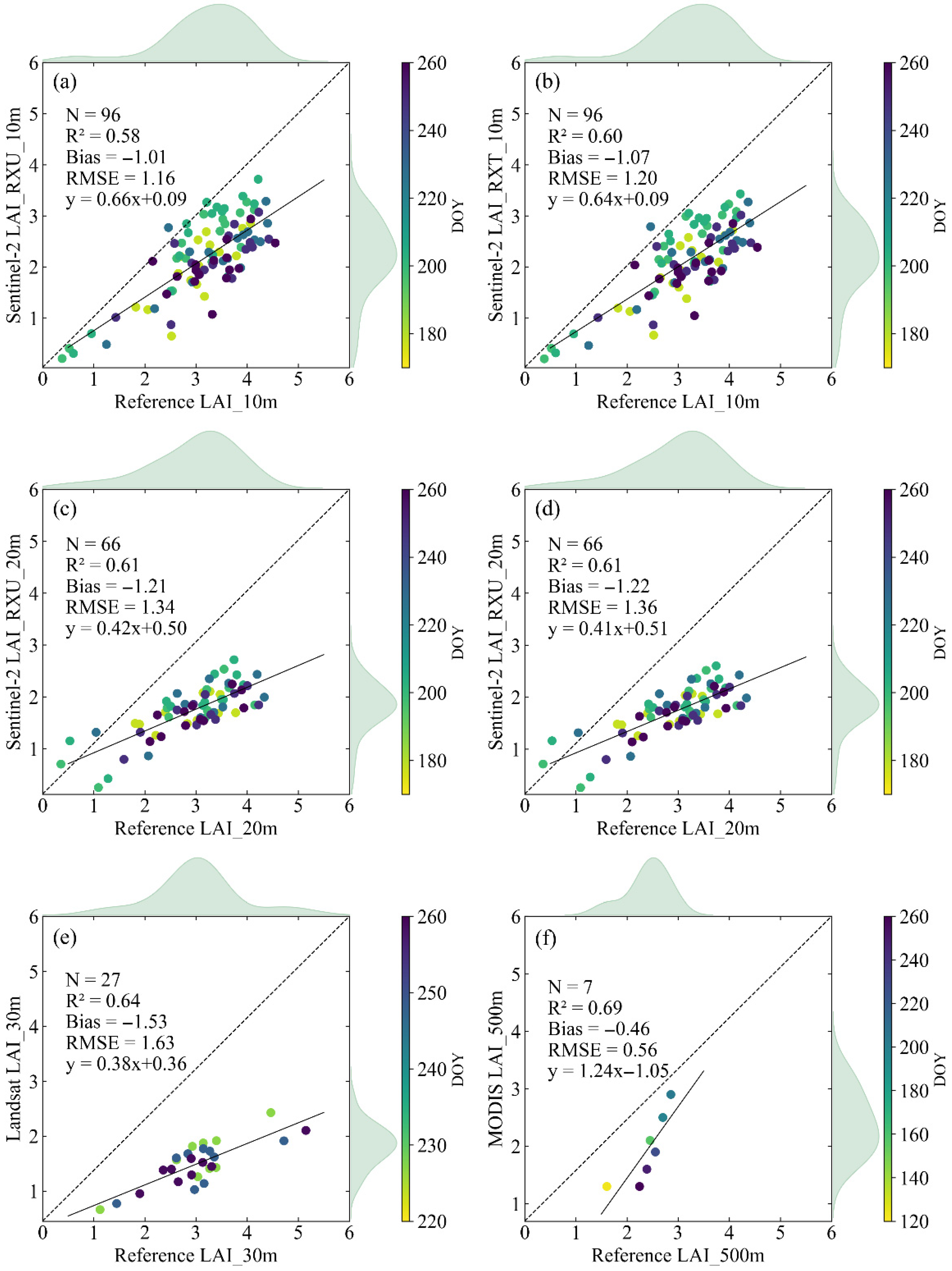
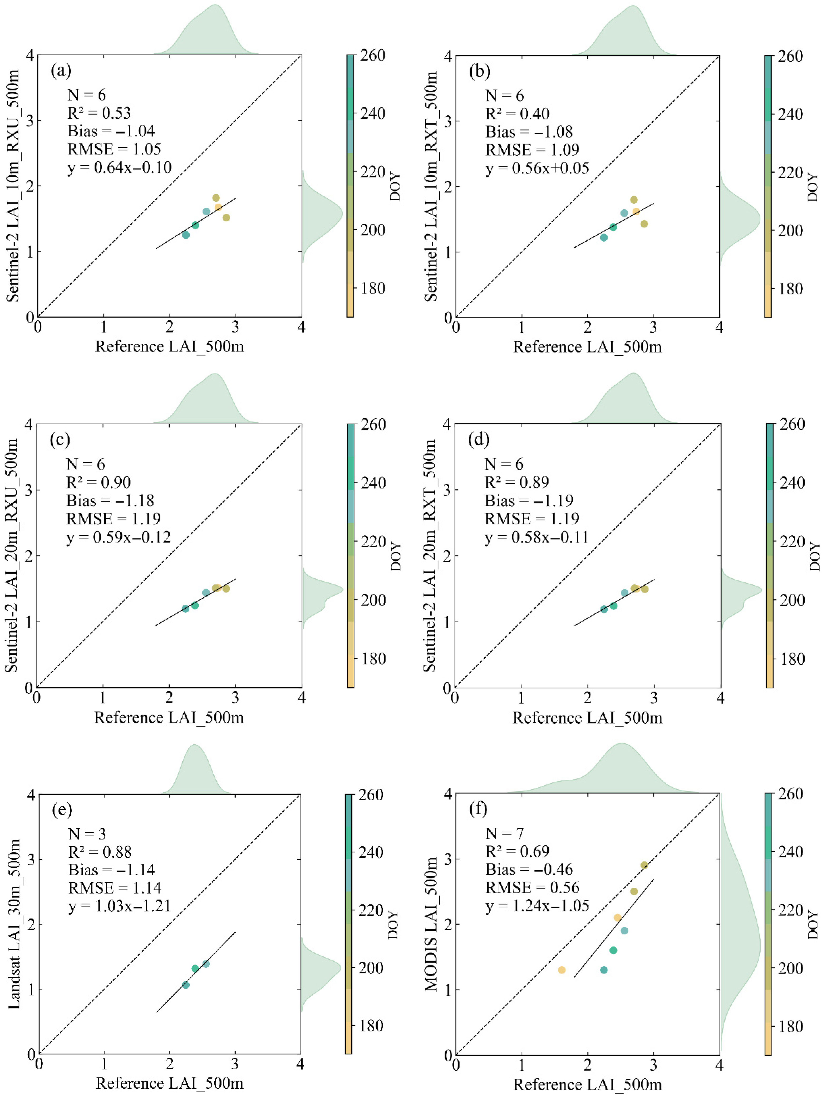
- A systematic underestimation across all the LAI products within the study area.
- The MCD15A3H LAI product gave the highest accuracy (RMSE = 0.56, R2 = 0.69).
- The surface heterogeneity in mountainous areas significantly affects the LAI values and the quality of global LAI products, necessitating a comprehensive accuracy assessment prior to their application in such regions.
- When developing retrieval models, comprehensive consideration should be given to topographic factors and other parameters that affect model accuracy; thereby, establishing a more precise upscaling bridge for validation.
Abstract
1. Introduction
2. Study Area and Data
2.1. Study Area
2.2. Data
2.2.1. Field-Measured LAI
2.2.2. UAV Images
2.2.3. Fine-Resolution LAI Maps
2.2.4. LAI Products
3. Methods
3.1. Exponential Model Fitting of NDVI-LAI
| Date | Fitting Equation | Uncertainty |
|---|---|---|
| 2023/5/3 | LAI = 0.0318 | 0.48 |
| 2023/6/6 | LAI = 0.0141 | 0.57 |
| 2023/6/27 | LAI = 0.1215 | 0.47 |
| 2023/7/17 | LAI = 0.0791 | 0.33 |
| 2023/7/22 | LAI = 0.0592 | 0.40 |
| 2023/8/15 | LAI = 0.1272 | 0.42 |
| 2323/9/5 | LAI = 0.094 | 0.29 |
| 2023/9/15 | LAI = 0.0564 | 0.26 |
3.2. Scale Conversion
4. Results
4.1. Comparison of Predicted and Measured Values
4.2. Hierarchical Validation of Multi-Scale Products
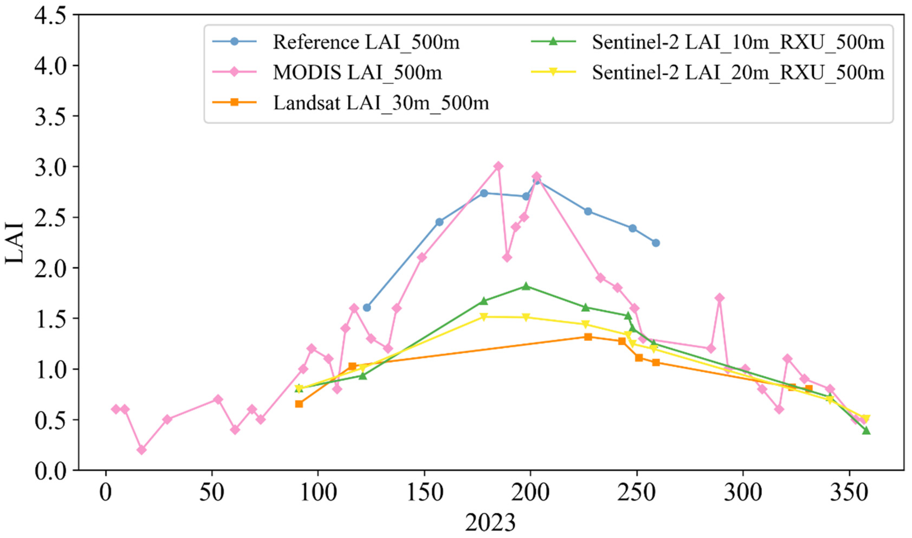
4.3. Temporal Consistency Validation
4.3.1. Temporal Consistency Validation of Products with Reference LAI Maps
4.3.2. Cross-Validation of Temporal Consistency of Remote Sensing Products
4.4. Validation of Sentinel-2 Products for Different Vegetation Types
5. Discussion
6. Conclusions
Author Contributions
Funding
Data Availability Statement
Conflicts of Interest
References
- Chen, J.M.; Black, T.A. Defining Leaf Area Index for Non-Flat Leaves. Plant Cell Environ. 1992, 15, 421–429. [Google Scholar] [CrossRef]
- Badhwar, G.D.; Macdonald, R.B. Satellite-Derived Leaf-Area-Index and Vegetation Maps as Input to Global Carbon Cycle Models-a Hierarchical Approach. Int. J. Remote Sens. 1986, 7, 265–281. [Google Scholar] [CrossRef]
- Stark, S.C.; Leitold, V.; Wu, J.L.; Hunter, M.O.; De Castilho, C.V.; Costa, F.R.C.; McMahon, S.M.; Parker, G.G.; Shimabukuro, M.T.; Lefsky, M.A.; et al. Amazon Forest Carbon Dynamics Predicted by Profiles of Canopy Leaf Area and Light Environment. Ecol. Lett. 2012, 15, 1406–1414. [Google Scholar] [CrossRef] [PubMed]
- Asner, G.P.; Scurlock, J.M.O.; Hicke, J.A. Global Synthesis of Leaf Area Index Observations: Implications for Ecological and Remote Sensing Studies. Glob. Ecol. 2003, 12, 191–205. [Google Scholar] [CrossRef]
- Running, S.W.; Baldocchi, D.D.; Turner, D.P.; Gower, S.T.; Bakwin, P.S.; Hibbard, K.A. A Global Terrestrial Monitoring Network Integrating Tower Fluxes, Flask Sampling, Ecosystem Modeling and EOS Satellite Data. Remote Sens. Environ. 1999, 70, 108–127. [Google Scholar] [CrossRef]
- Bonan, G.B. Land-Atmosphere Interactions for Climate System Models: Coupling Biophysical, Biogeochemical, and Ecosystem Dynamical Processes. Remote Sens. Environ. 1995, 51, 57–73. [Google Scholar] [CrossRef]
- Chen, J.M.; Rich, P.M.; Gower, S.T.; Norman, J.M.; Plummer, S. Leaf Area Index of Boreal Forests: Theory, Techniques, and Measurements. J. Geophys. Res. Atmos. 1997, 102, 29429–29443. [Google Scholar] [CrossRef]
- Justice, C.; Belward, A.; Morisette, J.; Lewis, P.; Privette, J.; Baret, F. Developments in the “validation” of Satellite Sensor Products for the Study of the Land Surface. Int. J. Remote Sens. 2000, 21, 3383–3390. [Google Scholar] [CrossRef]
- Fang, H.; Wang, Y.; Zhang, Y.; Li, S. Long-Term Variation of Global GEOV2 and MODIS Leaf Area Index (LAI) and Their Uncertainties: An Insight into the Product Stabilities. J. Remote Sens. 2021, 2021, 9842830. [Google Scholar] [CrossRef]
- Zeng, Y.; Li, J.; Liu, Q. Global LAI Ground Validation Dataset and Product Validation Framework. Adv. Earth Sci. 2012, 27, 165–174. [Google Scholar]
- Garrigues, S.; Lacaze, R.; Baret, F.; Morisette, J.T.; Weiss, M.; Nickeson, J.E.; Fernandes, R.; Plummer, S.; Shabanov, N.V.; Myneni, R.B.; et al. Validation and Intercomparison of Global Leaf Area Index Products Derived from Remote Sensing Data. J. Geophys. Res. Biogeosci. 2008, 113, 2007JG000635. [Google Scholar] [CrossRef]
- Yin, G.; Li, A.; Jin, H.; Zhao, W.; Bian, J.; Qu, Y.; Zeng, Y.; Xu, B. Derivation of Temporally Continuous LAI Reference Maps through Combining the LAINet Observation System with CACAO. Agric. For. Meteorol. 2017, 233, 209–221. [Google Scholar] [CrossRef]
- Yan, K.; Park, T.; Yan, G.; Liu, Z.; Yang, B.; Chen, C.; Nemani, R.; Knyazikhin, Y.; Myneni, R. Evaluation of MODIS LAI/FPAR Product Collection 6. Part 2: Validation and Intercomparison. Remote Sens. 2016, 8, 460. [Google Scholar] [CrossRef]
- Breda, N.J.J. Ground-Based Measurements of Leaf Area Index: A Review of Methods, Instruments and Current Controversies. J. Exp. Bot. 2003, 54, 2403–2417. [Google Scholar] [CrossRef]
- Fang, H.; Baret, F.; Plummer, S.; Schaepman- Strub, G. An Overview of Global Leaf Area Index (LAI): Methods, Products, Validation, and Applications. Rev. Geophys. 2019, 57, 739–799. [Google Scholar] [CrossRef]
- Yan, G.; Hu, R.; Luo, J.; Weiss, M.; Jiang, H.; Mu, X.; Xie, D.; Zhang, W. Review of Indirect Optical Measurements of Leaf Area Index: Recent Advances, Challenges, and Perspectives. Agric. For. Meteorol. 2019, 265, 390–411. [Google Scholar] [CrossRef]
- Nasahara, K.N.; Muraoka, H.; Nagai, S.; Mikami, H. Vertical Integration of Leaf Area Index in a Japanese Deciduous Broad-Leaved Forest. Agric. For. Meteorol. 2008, 148, 1136–1146. [Google Scholar] [CrossRef]
- Morisette, J.T.; Baret, F.; Privette, J.L.; Myneni, R.B.; Nickeson, J.E.; Garrigues, S.; Shabanov, N.V.; Weiss, M.; Fernandes, R.A.; Leblanc, S.G.; et al. Validation of Global Moderate-Resolution LAI Products: A Framework Proposed within the CEOS Land Product Validation Subgroup. IEEE Trans. Geosci. Remote Sens. 2006, 44, 1804–1817. [Google Scholar] [CrossRef]
- Song, B. Validation of Leaf Area Index Products Over Croplands in China; Aerospace Information Research Institute, Chinese Academy of Sciences: Beijing, China, 2022. [Google Scholar]
- Qu, Y.; Han, W.; Fu, L.; Li, C.; Song, J.; Zhou, H.; Bo, Y.; Wang, J. LAINet—A Wireless Sensor Network for Coniferous Forest Leaf Area Index Measurement: Design, Algorithm and Validation. Comput. Electron. Agric. 2014, 108, 200–208. [Google Scholar] [CrossRef]
- Fang, H.; Zhang, Y.; Wei, S.; Li, W.; Ye, Y.; Sun, T.; Liu, W. Validation of Global Moderate Resolution Leaf Area Index (LAI) Products over Croplands in Northeastern China. Remote Sens. Environ. 2019, 233, 111377. [Google Scholar] [CrossRef]
- Yan, K.; Park, T.; Chen, C.; Xu, B.; Song, W.; Yang, B.; Zeng, Y.; Liu, Z.; Yan, G.; Knyazikhin, Y.; et al. Generating Global Products of LAI and FPAR From SNPP-VIIRS Data: Theoretical Background and Implementation. IEEE Trans. Geosci. Remote Sens. 2018, 56, 2119–2137. [Google Scholar] [CrossRef]
- Verrelst, J.; Camps-Valls, G.; Muñoz-Marí, J.; Rivera, J.P.; Veroustraete, F.; Clevers, J.G.P.W.; Moreno, J. Optical Remote Sensing and the Retrieval of Terrestrial Vegetation Bio-Geophysical Properties—A Review. ISPRS J. Photogramm. Remote Sens. 2015, 108, 273–290. [Google Scholar] [CrossRef]
- Baret, F.; Hagolle, O.; Geiger, B.; Bicheron, P.; Miras, B.; Huc, M.; Berthelot, B.; Niño, F.; Weiss, M.; Samain, O.; et al. LAI, fAPAR and fCover CYCLOPES Global Products Derived from VEGETATION. Remote Sens. Environ. 2007, 110, 275–286. [Google Scholar] [CrossRef]
- Houborg, R.; Soegaard, H.; Boegh, E. Combining Vegetation Index and Model Inversion Methods for the Extraction of Key Vegetation Biophysical Parameters Using Terra and Aqua MODIS Reflectance Data. Remote Sens. Environ. 2007, 106, 39–58. [Google Scholar] [CrossRef]
- Myneni, R.B.; Ramakrishna, R.; Nemani, R.; Running, S.W. Estimation of Global Leaf Area Index and Absorbed Par Using Radiative Transfer Models. IEEE Trans. Geosci. Remote Sens. 1997, 35, 1380–1393. [Google Scholar] [CrossRef]
- Baret, F.; Buis, S. Estimating Canopy Characteristics from Remote Sensing Observations: Review of Methods and Associated Problems. In Advances in Land Remote Sensing; Liang, S., Ed.; Springer: Dordrecht, The Netherlands, 2008; pp. 173–201. ISBN 978-1-4020-6449-4. [Google Scholar] [CrossRef]
- Lemaire, G.; Francois, C.; Soudani, K.; Berveiller, D.; Pontailler, J.; Breda, N.; Genet, H.; Davi, H.; Dufrene, E. Calibration and Validation of Hyperspectral Indices for the Estimation of Broadleaved Forest Leaf Chlorophyll Content, Leaf Mass per Area, Leaf Area Index and Leaf Canopy Biomass. Remote Sens. Environ. 2008, 112, 3846–3864. [Google Scholar] [CrossRef]
- Gitelson, A.A. Wide Dynamic Range Vegetation Index for Remote Quantification of Biophysical Characteristics of Vegetation. J. Plant Physiol. 2004, 161, 165–173. [Google Scholar] [CrossRef]
- Myneni, R.B.; Hall, F.G.; Sellers, P.J.; Marshak, A.L. The Interpretation of Spectral Vegetation Indexes. IEEE Trans. Geosci. Remote Sens. 1995, 33, 481–486. [Google Scholar] [CrossRef]
- Liu, T. Remote Sensing Estimation and Validation of Different Spatial Scales Forest LAI; Northeast Forestry University: Harbin, China, 2019. [Google Scholar]
- Li, D.; Huang, Y.; Xiao, Y.; He, M.; Wen, J.; Li, Y.; Ma, M. Evaluation of the High-Resolution MuSyQ LAI Product over Heterogeneous Land Surfaces. Remote Sens. 2023, 15, 1238. [Google Scholar] [CrossRef]
- Jacquemoud, S.; Baret, F. PROSPECT: A Model of Leaf Optical Properties Spectra. Remote Sens. Environ. 1990, 34, 75–91. [Google Scholar] [CrossRef]
- Djamai, N.; Fernandes, R.; Weiss, M.; McNairn, H.; Goïta, K. Validation of the Sentinel Simplified Level 2 Product Prototype Processor (SL2P) for Mapping Cropland Biophysical Variables Using Sentinel-2/MSI and Landsat-8/OLI Data. Remote Sens. Environ. 2019, 225, 416–430. [Google Scholar] [CrossRef]
- Knight, E.; Kvaran, G. Landsat-8 Operational Land Imager Design, Characterization and Performance. Remote Sens. 2014, 6, 10286–10305. [Google Scholar] [CrossRef]
- Masek, J.G.; Wulder, M.A.; Markham, B.; McCorkel, J.; Crawford, C.J.; Storey, J.; Jenstrom, D.T. Landsat 9: Empowering Open Science and Applications through Continuity. Remote Sens. Environ. 2020, 248, 111968. [Google Scholar] [CrossRef]
- Melnikova, I.; Awaya, Y.; Saitoh, T.; Muraoka, H.; Sasai, T. Estimation of Leaf Area Index in a Mountain Forest of Central Japan with a 30-m Spatial Resolution Based on Landsat Operational Land Imager Imagery: An Application of a Simple Model for Seasonal Monitoring. Remote Sens. 2018, 10, 179. [Google Scholar] [CrossRef]
- Yang, W.; Tan, B.; Huang, D. MODIS Leaf Area Index Products: From Validation to Algorithm Improvement. IEEE Trans. Geosci. Remote Sens. 2006, 44, 1885–1898. [Google Scholar] [CrossRef]
- Jin, H.; Li, A.; Bian, J.; Nan, X.; Zhao, W.; Zhang, Z.; Yin, G. Intercomparison and Validation of MODIS and GLASS Leaf Area Index (LAI) Products over Mountain Areas: A Case Study in Southwestern China. Int. J. Appl. Earth Obs. Geoinf. 2017, 55, 52–67. [Google Scholar] [CrossRef]
- Knyazikhin, Y.; Martonchik, J.V.; Myneni, R.B. Synergistic Algorithm for Estimating Vegetation Canopy Leaf Area Index and Fraction of Absorbed Photosynthetically Active Radiation from MODIS and MISR Data. J. Geophys. Res. Atmos. 1998, 103, 32257–32275. [Google Scholar] [CrossRef]
- Fang, H.; Wei, S.; Liang, S. Validation of MODIS and CYCLOPES LAI Products Using Global Field Measurement Data. Remote Sens. Environ. 2012, 119, 43–54. [Google Scholar] [CrossRef]
- Myneni, R.B.; Hoffman, S.; Knyazikhin, Y.; Privette, J.L.; Glassy, J.; Tian, Y.; Wang, Y.; Song, X. Global Products of Vegetation Leaf Area and Fraction Absorbed PAR from Year One of MODIS Data. Remote Sens. Environ. 2002, 83, 214–231. [Google Scholar] [CrossRef]
- Glenn, E.P.; Huete, A.R.; Nagler, P.L.; Nelson, S.G. Relationship Between Remotely-Sensed Vegetation Indices, Canopy Attributes and Plant Physiological Processes: What Vegetation Indices Can and Cannot Tell Us About the Landscape. Sensors 2008, 8, 2136–2160. [Google Scholar] [CrossRef]
- Brown, L.A.; Meier, C.; Morris, H.; Pastor-Guzman, J.; Bai, G.; Lerebourg, C.; Gobron, N.; Lanconelli, C.; Clerici, M.; Dash, J. Evaluation of Global Leaf Area Index and Fraction of Absorbed Photosynthetically Active Radiation Products over North America Using Copernicus Ground Based Observations for Validation Data. Remote Sens. Environ. 2020, 247, 111935. [Google Scholar] [CrossRef]
- Campos-Taberner, M.; García-Haro, F.J.; Camps-Valls, G.; Grau-Muedra, G.; Nutini, F.; Crema, A.; Boschetti, M. Multitemporal and Multiresolution Leaf Area Index Retrieval for Operational Local Rice Crop Monitoring. Remote Sens. Environ. 2016, 187, 102–118. [Google Scholar] [CrossRef]
- Majasalmi, T.; Rautiainen, M.; Stenberg, P.; Rita, H. Optimizing the Sampling Scheme for LAI-2000 Measurements in a Boreal Forest. Agric. For. Meteorol. 2012, 154–155, 38–43. [Google Scholar] [CrossRef]
- Demarez, V.; Duthoit, S.; Baret, F.; Weiss, M.; Dedieu, G. Estimation of Leaf Area and Clumping Indexes of Crops with Hemispherical Photographs. Agric. For. Meteorol. 2008, 148, 644–655. [Google Scholar] [CrossRef]
- Liu, L. Simulation and Correction of Spatialscaling Effects for Leaf Area Index. J. Remote Sens. 2014, 18, 1158–1168. [Google Scholar] [CrossRef]
- Hu, Q.; Yang, J.; Xu, B.; Huang, J.; Memon, M.S.; Yin, G.; Zeng, Y.; Zhao, J.; Liu, K. Evaluation of Global Decametric-Resolution LAI, FAPAR and FVC Estimates Derived from Sentinel-2 Imagery. Remote Sens. 2020, 12, 912. [Google Scholar] [CrossRef]
- Kganyago, M.; Mhangara, P.; Alexandridis, T.; Laneve, G.; Ovakoglou, G.; Mashiyi, N. Validation of Sentinel-2 Leaf Area Index (LAI) Product Derived from SNAP Toolbox and Its Comparison with Global LAI Products in an African Semi-Arid Agricultural Landscape. Remote Sens. Lett. 2020, 11, 883–892. [Google Scholar] [CrossRef]
- Camacho, F.; Cernicharo, J.; Lacaze, R.; Baret, F.; Weiss, M. GEOV1: LAI, FAPAR Essential Climate Variables and FCOVER Global Time Series Capitalizing over Existing Products. Part 2: Validation and Intercomparison with Reference Products. Remote Sens. Environ. 2013, 137, 310–329. [Google Scholar] [CrossRef]
- Shen, Z.; Liu, Z.; Wu, J. Altitudinal Pattern of Flora on the Eastern of Slope of Mt. Gongga. Biodivers. Sci. 2004, 12, 89. [Google Scholar]
- Campos-Taberner, M.; García-Haro, F.; Busetto, L.; Ranghetti, L.; Martínez, B.; Gilabert, M.A.; Camps-Valls, G.; Camacho, F.; Boschetti, M. A Critical Comparison of Remote Sensing Leaf Area Index Estimates over Rice-Cultivated Areas: From Sentinel-2 and Landsat-7/8 to MODIS, GEOV1 and EUMETSAT Polar System. Remote Sens. 2018, 10, 763. [Google Scholar] [CrossRef]
- Yu, W.; Li, J.; Liu, Q. Extraction and Analysis of Land Cover Heterogeneity over China. Adv. Earth Sci. 2016, 31, 1067–1077. [Google Scholar] [CrossRef]
- Yao, Y.; Liu, Q.; Liu, Q.; Li, X. LAI Inversion Uncertainties in Heterogeneous Surface. J. Remote Sens. 2007, 11, 763–770. [Google Scholar] [CrossRef]
- Brown, L.A.; Ogutu, B.O.; Dash, J. Estimating forest leaf area index and canopy chlorophyll content with Sentinel-2: An evaluation of two hybrid retrieval algorithms. Remote Sens. 2019, 11, 1752. [Google Scholar] [CrossRef]
- Xie, Q.; Dash, J.; Huete, A.; Jiang, A.; Yin, G.; Ding, Y.; Peng, D.; Hall, C.C.; Brown, L.; Shi, Y.; et al. Retrieval of crop biophysical parameters from Sentinel-2 remote sensing imagery. Int. J. Appl. Earth Obs. Geoinf. 2019, 80, 187–195. [Google Scholar] [CrossRef]
- Cheng, Q. Validation and correction of MOD15-LAI using in situ rice LAI in southern China. Commun. Soil Sci. Plant Anal. 2008, 39, 1658–1669. [Google Scholar] [CrossRef]
- Pinty, B.; Andredakis, I.; Clerici, M.; Kaminski, T.; Taberner, M.; Verstraete, M.M.; Gobron, N.; Plummer, S.; Widlowski, J.-L. Exploiting the MODIS albedos with the Two-stream Inversion Package (JRC-TIP): 1. Effective leaf areaindex, vegetation, and soil properties. J. Geophys. Res. 2011, 116, D09105. [Google Scholar] [CrossRef]
- Pasolli, L.; Asam, S.; Castelli, M.; Bruzzone, L.; Wohlfahrt, G.; Zebisch, M.; Notarnicola, C. Retrieval of Leaf Area Index in Mountain grasslands in the Alps from MODIS satellite imagery. Remote Sens. Environ. 2015, 165, 159–174. [Google Scholar] [CrossRef]
- Ma, M.; Che, T.; Li, X.; Xiao, Q.; Zhao, K.; Xin, X. A Prototype Network for Remote Sensing Validation in China. Remote Sens. 2015, 7, 5187–5202. [Google Scholar] [CrossRef]
- Chen, W.; Cao, C. Topographic correction-based retrieval of leaf area index in mountain areas. J. Mt. Sci. 2012, 9, 166–174. [Google Scholar] [CrossRef]



| LAI Products | Sensor | Time Resolution | Spatial Resolution | Inversion Algorithm |
|---|---|---|---|---|
| Sentinel-2 LAI | MSI | 5 days | 10 m/ 20 m | PROSAIL and Neural Networks |
| Landsat-8/9 LAI | OLI | 8 days | 30 m | PROSAIL and Neural Networks |
| MCD15A3H LAI | MODIS | 4 days | 500 m | RTM 3D (LUT)/ NDVI-LAI empirical model |
| Vegetation Types | RMSE | Bias | R2 | |||
|---|---|---|---|---|---|---|
| Sentinel-2 LAI_RXU | Sentinel-2 LAI_RXT | Sentinel-2 LAI_RXU | Sentinel-2 LAI_RXT | Sentinel-2 LAI_RXU | Sentinel-2 LAI_RXT | |
| Forestland | 0.89 | 0.93 | −0.72 | −0.78 | 0.08 | 0.07 |
| Cropland | 1.11 | 1.11 | −0.87 | −0.88 | 0.53 | 0.53 |
| Grassland | 1.19 | 1.24 | −1.07 | −1.14 | 0.24 | 0.26 |
| Shrubland | 1.29 | 1.35 | −1.21 | −1.28 | 0.49 | 0.53 |
Disclaimer/Publisher’s Note: The statements, opinions and data contained in all publications are solely those of the individual author(s) and contributor(s) and not of MDPI and/or the editor(s). MDPI and/or the editor(s) disclaim responsibility for any injury to people or property resulting from any ideas, methods, instructions or products referred to in the content. |
© 2025 by the authors. Licensee MDPI, Basel, Switzerland. This article is an open access article distributed under the terms and conditions of the Creative Commons Attribution (CC BY) license (https://creativecommons.org/licenses/by/4.0/).
Share and Cite
Liu, M.; Yu, W.; Li, D.; Shang, F.; Zhang, L.; Wang, S.; Yang, W.; Zhao, R.; Wang, X. Validation of Multi-Scale LAI Products in Heterogeneous Terrain-Based UAV Images. Remote Sens. 2025, 17, 3393. https://doi.org/10.3390/rs17193393
Liu M, Yu W, Li D, Shang F, Zhang L, Wang S, Yang W, Zhao R, Wang X. Validation of Multi-Scale LAI Products in Heterogeneous Terrain-Based UAV Images. Remote Sensing. 2025; 17(19):3393. https://doi.org/10.3390/rs17193393
Chicago/Turabian StyleLiu, Meng, Wenping Yu, Dandan Li, Fangfang Shang, Longlong Zhang, Shuangjie Wang, Wen Yang, Ruoyi Zhao, and Xuemei Wang. 2025. "Validation of Multi-Scale LAI Products in Heterogeneous Terrain-Based UAV Images" Remote Sensing 17, no. 19: 3393. https://doi.org/10.3390/rs17193393
APA StyleLiu, M., Yu, W., Li, D., Shang, F., Zhang, L., Wang, S., Yang, W., Zhao, R., & Wang, X. (2025). Validation of Multi-Scale LAI Products in Heterogeneous Terrain-Based UAV Images. Remote Sensing, 17(19), 3393. https://doi.org/10.3390/rs17193393


