Highlights
What are the main findings?
- A systematic underestimation across all the LAI products within the study area.
- The MCD15A3H LAI product gave the highest accuracy (RMSE = 0.56, R2 = 0.69).
What are the implications of the main findings?
- The surface heterogeneity in mountainous areas significantly affects the LAI values and the quality of global LAI products, necessitating a comprehensive accuracy assessment prior to their application in such regions.
- When developing retrieval models, comprehensive consideration should be given to topographic factors and other parameters that affect model accuracy; thereby, establishing a more precise upscaling bridge for validation.
Abstract
Significant uncertainties persist across different Leaf Area Index (LAI) products due to multiple factors; therefore, the accuracy assessment of the global LAI products is an indispensable step before their application. In this study, comprehensive validation of multi-scale LAI products including Sentinel-2, Landsat-8/9, and MCD15A3H was implemented utilizing fine-resolution LAI maps which were based on UAV images and field-measured LAI data. The validation results demonstrated a consistent, systematic underestimation across all the LAI products within the study area, the RMSE of these products ranged from 0.56 to 1.63, and the coarse-resolution MCD15A3H LAI product demonstrated highest accuracy (RMSE = 0.56, R2 = 0.69). The Sentinel-2 products exhibited intermediate accuracy among all those products (RMSE: 1.16–1.36). The Landsat-8/9 LAI product showed markedly lower accuracy relative to Sentinel-2; its RMSE (1.63) exceeded that of Sentinel-2 10 m LAI and 20 m LAI by 40.52% and 21.64%, respectively. In addition, all these LAI products showed consistent seasonal variation patterns with the reference LAI maps. Moreover, Sentinel-2 10 m LAI products showed serious underestimation for all vegetation types, with forests providing the highest RMSE = 0.89. This study serves as a valuable reference for the application of multi-scale LAI products in heterogeneous terrain and provides directions for the improvement of fine-resolution LAI retrieval algorithms.
1. Introduction
The Leaf Area Index (LAI) is defined as one half of the total green leaf area per unit ground surface area [1] and serves as a critical biophysical parameter for characterizing both the structure and growth vigor of terrestrial vegetation [2]. LAI is the primary biophysical variable governing the exchanges of carbon dioxide, water vapor, and energy between terrestrial ecosystems and the atmosphere [3,4]. As leaves constitute the primary functional units of plant canopies, the LAI directly governs the capture and utilization of solar radiation; thereby, it is closely linked to carbon cycling, leaf respiration, transpiration, and photosynthesis. It is consequently recognized as the pivotal parameter in terrestrial ecosystem models [5,6]. Existing global LAI remote sensing products with varying spatiotemporal resolutions are derived through different retrieval algorithms. These products have significant applications across multiple domains including ecophysiology, atmosphere–ecosystem interactions, and global change studies [7]. Currently, numerous LAI products have been generated worldwide. Notably, NASA has produced the LAI product series based on MODIS sensor data (2000–present). The European Space Agency (ESA) has released multiple generations of global LAI products (including CYCLOPES, GEOV1, and GEOV2) derived from SPOT/VEGETATION data. Additionally, China has developed domestic LAI products such as GLOBALBNU and MusyQ, further enriching the global LAI product inventory. In the domain of LAI products, China domestically developed an LAI product series (e.g., GLOBALBNU and MusyQ) which have achieved significant advances in both algorithm innovation and validation accuracy. These products have undergone continuous evaluation through global, distributed validation networks (e.g., VALERI, BELMANIP2), providing a scientific basis for product selection across different application scenarios. While these data products establish a fundamental basis for researchers to better analyze our living planet, most remote sensing products are generated at a global scale with spatial resolutions ranging from hundreds of meters to kilometers, making them inadequate for precisely characterizing the detailed features of heterogeneous land surfaces. In areas with heterogeneous surfaces, particularly in fragmented vegetation or ecotone zones, mixed-pixel effects become pronounced, directly compromising the spatial representativeness and retrieval accuracy of the products. Therefore, systematic validation must be conducted prior to the regional or local applications of these remote sensing products to quantitatively assess their accuracy and delineate applicable domains and uncertainty sources.
Validation serves as an essential methodology for assessing the quality of remote sensing retrieval products and verifying whether Earth observation products accurately represent surface truth conditions. In addition, validation aims to systematically quantify the accuracy of remote sensing products for specific study regions using standardized metrics, comparative analysis between remote sensing retrieval products, and reference data representing ground truth values (including but not limited to in situ measurements, airborne observations, and high-resolution remote sensing data), conducted to evaluate the precision and accuracy of remote sensing products, and rigorously analyze error sources and their spatial distribution patterns. Only by understanding accuracy limitations and their origins can these products be utilized as reliable data sources for scientific research [8]. Validated products with well-quantified uncertainty metrics, despite subsequent improved versions becoming available, remain essential for long-term and systematic scientific research [9]. The development of validation protocols and methodologies for regional-to-global scale remote sensing products has evolved in parallel with the standardization of global satellite data production [10]. For LAI product validation specifically, the Land Product Validation (LPV) subgroup under CEOS’s Working Group on Calibration and Validation (WGCV) has established a validation framework incorporating both direct and indirect approaches [11]. The VALERI project, initiated in 2000, formally established a two-level sampling strategy based on Elementary Sampling Units (ESUs), which was subsequently refined into a comprehensive “bottom-up” validation framework through follow-up initiatives. This bottom-up methodology involves several critical steps: quantifying spatial variability through multiple ESUs, where ESU dimensions are typically designed to match high-resolution pixel sizes; developing empirical relationships between ESU-LAI values and high-resolution reflectance/vegetation indices to generate fine-resolution LAI maps; and performing validation through upscaling fine-resolution LAI maps to match the target product’s pixel resolution.
To better characterize the consistencies of current LAI products and their respective uncertainties, most validation activities have been implemented over a typical validation network of sites for direct validation or a regional/global scale for product intercomparison [12], overlooking the impact of topographic effects in mountainous areas [13]. The complexity of mountain terrains and the high degree of landscape fragmentation significantly constrain the quality of LAI products [14]. Moreover, the inversion accuracy of LAI products in mountainous regions is difficult to guarantee as most algorithms do not consider topographic factors [15]. Consequently, LAI product validation becomes particularly challenging in mountainous regions characterized by severe landscape fragmentation, complex terrain variability, and high vegetation spatial heterogeneity. This study, which implemented tailored data collection approaches adapted to the complex surface conditions of the study area with fine-resolution LAI maps derived from centimeter-scale UAV imagery and field-measured LAI serving as the validation benchmark, systematically evaluates multi-resolution LAI products (Sentinel-2 10/20 m, Landsat 30 m, MODIS 500 m) in mountainous terrain, providing methodological references for both product application and algorithm refinement.
This study focuses on a 500 m × 500 m area within the Caoshang Remote Sensing Observation Station in Beibei District, Chongqing. Field-measured LAI measurements were acquired using LAINet instruments deployed through an improved Multi-scale Nested Sampling Methodology (MNSM). Fine-resolution LAI maps were generated by establishing empirical relationships between these LAI measurements and sub-meter resolution NDVI derived from UAV multispectral imagery. Utilizing field-measured LAI data at predetermined ESU scales and acquiring synchronized, co-located high-resolution UAV multispectral data, this study generated fine-resolution LAI maps through LAI-NDVI empirical modeling, which were then upscaled to match the spatial resolution of the target remote sensing products for validation. These reference LAI maps were subsequently employed to validate multiple decameter- and hectometer-scale remote sensing products, assessing their accuracy performance under the complex surface conditions characteristic of southwestern mountainous regions. Furthermore, analysis of Sentinel-2 LAI product performance was carried out across vegetation types based on deployment characteristics.
2. Study Area and Data
2.1. Study Area
The study area is located at the Caoshang Remote Sensing Observation Station (29°47′14″N, 106°26′33″E) in Beibei District, Chongqing. Situated within the mountainous region of the eastern Sichuan parallel ridge-valley system, in the Zhongliangshan Longfeng trough valley area, this site represents a typical karst trough landform characterized by significant topographic relief, fragile ecosystems, and complex terrain. The area experiences a subtropical monsoon humid climate with frequent cloud cover and limited annual sunshine. The land surface composition primarily consists of exposed bedrock, natural vegetation, cultivated land, and buildings. Within a delineated 500 m × 500 m study plot (Figure 1), we implemented an improved Multi-scale Nested Sampling Methodology (MNSM) to establish 18 Elementary Sampling Units (ESUs) measuring 0.5 m × 0.5 m each. The ESU distribution comprised 3 cropland units, 3 forested units, 5 shrubland units, and 7 grassland units. Each ESU was instrumented with LAINet sensors (Beijing Star Viewer Science and Technology Ltd., Beijing, China)to systematically acquire LAI measurements across the Caoshang terrain.
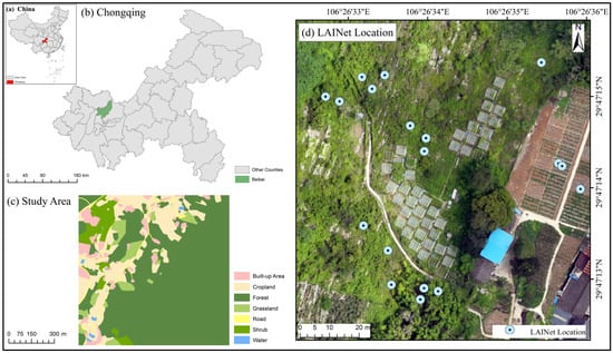
Figure 1.
Study area.
2.2. Data
2.2.1. Field-Measured LAI
Ground-based LAI measurements play a crucial role in monitoring vegetation growth status and serve as essential reference data for the validation of remote sensing products [16,17,18]. Ground-based LAI measurements primarily consist of direct and indirect methods. Direct LAI measurement approaches include destructive sampling, allometric modeling, and litterfall collection techniques [19,20,21]. Indirect measurement methods include optical approaches based on Beer’s Law and the inclined point quadrat method, which derive LAI by quantifying ancillary variables such as gap fraction, light transmission, and contact frequency [20]. This study employed indirect methods for field-measured LAI data acquisition. However, the current LAI measurement instruments exhibit certain limitations when conducting long-term time-series observations and large-area monitoring, primarily manifested in their requirement for manual point-by-point operation during the measurement process [22], which hinders synchronous multi-point and automated monitoring. Therefore, this study uses LAINet instrumentation (Beijing Star Viewer Science and Technology Ltd., Beijing, China) for field-measured LAI observations to enhance measurement efficiency and meet the research requirements for spatiotemporal continuity. LAINet represents an automated measurement system that employs wireless sensor network (WSN) technology to track solar trajectories and acquire multi-angular canopy transmittance data, subsequently deriving crop LAI through inversion of gap fraction models using the obtained multi-angular transmission measurements [23]. The LAINet system mainly consists of distributed below-node (BN) units positioned beneath the canopy to measure transmitted solar radiation, above-node (AN) units installed above the canopy to capture incoming solar radiation, and central node (CN) units that function as data receivers and system controllers [24]. LAINet can be configured according to researchers’ requirements to set the operational time and sampling frequencies, ensuring sufficient operational duration and battery capacity to cover the entire growing season of vegetation in the study area. In this study, 18 LAINet observation nodes were deployed across four vegetation types (shrubland, grassland, woodland, and cropland) using an improved Multi-scale Nested Sampling Method (MNSM) to collect LAI during the 2023 growing season. The nodes were programmed to operate daily from 06:00 to 18:30 local time, acquiring multi-angular canopy transmittance measurements at 10-min intervals. All measurements contributed to daily LAI estimates, which were subsequently averaged across multiple days to generate continuous LAI time series. A 7-day moving window was applied to smooth weather-induced fluctuations in the LAI data.
2.2.2. UAV Images
Due to the spatial resolution mismatch between field-measured data and remote sensing products, the validation of LAI products necessitates the utilization of fine-resolution LAI maps as scaling intermediaries to bridge the spatial resolution gap between field-measured data and remote sensing products. This process involves establishing empirical relationships between field-measured LAI and high-resolution data (e.g., reflectance or vegetation indices) to generate fine-resolution LAI maps, which are subsequently upscaled to match the spatial resolution of the target remote sensing products for comparative accuracy assessment. In previous studies, high-resolution imagery data were predominantly sourced from open-access global decameter-scale remote sensing products (e.g., Landsat Surface Reflectance data). These datasets were utilized to generate fine-resolution LAI maps through appropriate NDVI-LAI model inversion approaches [23]. Furthermore, fine-resolution LAI maps were generated by synergistically using HJ-1 WVC and Landsat 7 ETM+ surface reflectance data through a multi-scale data fusion approach [25]. This study employed higher-precision DJI Phantom 4 Multispectral (P4M) unmanned aerial vehicles (Shenzhen Dajiang Innovation Technology Co., Ltd. Shenzhen, China.) to synchronously acquire centimeter-scale imagery across the study area. The P4M integrates one RGB camera and five multispectral sensors (blue, green, red, red-edge, and near-infrared bands), responsible for visible light imaging and multispectral imaging, respectively. Operating at 200 m flight altitude, the platform captured eight multispectral scenes in 2023 with approximately 0.5 m spatial resolution.
2.2.3. Fine-Resolution LAI Maps
Over the past several decades, the estimation of LAI from remote sensing data has been extensively explored and advanced significantly [26,27,28,29,30]. Remote sensing-based LAI retrieval methods primarily include empirical statistical approaches and physical model-based methods [31]. The most commonly used LAI retrieval approach is based on establishing empirical or semi-empirical statistical models between vegetation indices (i.e., combinations of surface reflectance) and field-measured LAI values [32,33]. Vegetation indices exhibit robust quantitative relationships with LAI, vegetation index-based approaches are designed to maximize sensitivity to vegetation characteristics while minimizing perturbations from atmospheric noise, soil background variations, and observational geometry effects [34]. Numerous vegetation indices have been employed for LAI retrieval, including two-band indices such as the Normalized Difference Vegetation Index (NDVI) and Soil-Adjusted Vegetation Index (SAVI), as well as three-band indices like the Enhanced Vegetation Index (EVI) and Soil and Atmospherically Resistant Vegetation Index (SARVI). Through multispectral measurement data collected in the Beijing region, Song et al. [23] conducted regression modeling analyses between LAI and four vegetation indices (NDVI, SAVI, EVI, and SARVI) and identified that the NDVI demonstrates more robust relationships with LAI compared to other vegetation indices, particularly in heterogeneous environments. Similarly, Liu et al. [35] utilized GF-2, Sentinel-2, and Landsat-8 multispectral data to develop statistical models between field-measured LAI and four vegetation indices (NDVI, SR, SAVI, ARVI) for forest LAI estimation. This study, based on regional characteristics and existing research findings [36] and comparing four fitting models: exponential, polynomial, logarithmic, and linear, revealed that the exponential model demonstrated better performance in retrieval, achieving the highest R2 (0.83) and the smallest RMSE (0.53). Consequently, the exponential model was selected for the retrieval, eight contemporaneous high-resolution NDVI images were selected, and models were constructed using LAI data obtained from continuous LAINet observations in 2023 to retrieve fine-resolution LAI maps. In addition, non-vegetated surfaces, including roads, buildings, and water bodies, were masked and assigned an LAI value of 0 to exclude their influence on vegetation analysis.
2.2.4. LAI Products
With the advancement of remote sensing technologies and the deepening of scientific research, diverse remote sensing products have subsequently emerged. For example, the MODIS sensor has been utilized to generate LAI products continuously since 2000, the VEGETATION sensor onboard SPOT satellites has been used to produce successive LAI product series, CYCLOPES, GEOV1, and GEOV2, as well as domestic products such as GLOBALBNU and MusyQ. This study primarily evaluates the performance of three LAI products in the study area. The following table (Table 1) provides the characteristics of the three LAI products to be validated, including Sentinel-2 LAI, Landsat-8/9 LAI, and MCD15A3H LAI.

Table 1.
Characteristics of the LAI products under study.
The Sentinel-2 high-resolution multispectral imaging constellation, consisting of the Sentinel-2A satellite (launched in 2015) and Sentinel-2B satellite (launched in 2017), carries the Multi-Spectral Instrument (MSI). The MSI sensor covers 13 spectral bands, ranging from visible light and near-infrared to shortwave infrared. Designed for land monitoring, it systematically provides data on terrestrial vegetation growth dynamics, soil cover characteristics, and inland/coastal aquatic environments and other datasets. The revisit period for one satellite is 10 days, and when both the A and B satellites operate simultaneously, a complete Earth imaging cycle for the equatorial region is completed every 5 days. For higher-latitude areas like Europe, the cycle is reduced to 3 days. The sensor captures images in 13 spectral bands, the spatial resolution for these bands is 10 m (blue, green, red, and near-infrared), 20 m (three vegetation red-edge bands, near-infrared narrow bands, and two shortwave infrared bands), and 60 m (coastal aerosol, water vapor, and mid-wave cloud bands). In optical data, Sentinel-2 is the only one with three bands in the red-edge range, which is crucial for monitoring vegetation health. In this study, Sentinel-2 L2A data for the entire year of 2023 were collected from the Sentinel data access center (https://dataspace.copernicus.eu/ (accessed on 31 December 2023)), with 20 cloud-free images covering the study area. All bands were resampled to 10 m and 20 m, then clipped according to the study area. The SL2P algorithm was then used to estimate LAI. SL2P is an ensemble based on a backpropagation Artificial Neural Network (ANN), using a global representative set of canopy radiative transfer (RT) models (PROSAILH: PROSPECT + SAILH) [37] for training [38].
The Landsat series satellites have a 42-year history since the launch of Landsat-1 in 1972, making it the longest-running Earth observation program. Its data are extensively utilized in agriculture, climate change studies, and ecosystem conservation, among other fields. Currently, the operational Landsat satellites are Landsat-8/9. Landsat-8 carries the Operational Land Imager (OLI), which includes eight bands with a 30 m spatial resolution (covering visible light, near-infrared, and shortwave infrared spectral regions) and one band with a 15 m spatial resolution for panchromatic imaging [39], with a revisit cycle of 16 days. Landsat-9, launched on 27 September 2021, carries the second-generation OLI (OLI-2) and provides images with consistent spectral, spatial, radiometric, and geometric quality to Landsat-8 [40], with the same revisit period of 16 days. Compared to previous MSS, TM, or ETM+ sensors, Landsat OLI offers a 30 m spatial resolution and enhanced spectral performance, improving the accuracy of ecosystem structure estimation at the landscape scale [41]. In this study, all cloud-free Collection 2 (C2) Level 2 Science Product (L2SP) data for 2023 were collected from the US Geological Survey (USGS) website (https://espa.cr.usgs.gov/ (accessed on 31 December 2023)), which underwent atmospheric correction based on top-of-atmosphere (TOA) reflectance, providing a total of eight images. All bands were resampled to 30 m and clipped to the study area; then, LAI was calculated using the Biophysical Processor module on the SNAP software (ESA SNAP 10.0.0) platform.
The Terra satellite, launched on 18 December 1999, and the Aqua satellite, launched on 4 May 2002, both carry the Moderate Resolution Imaging Spectroradiometer (MODIS), which has generated numerous LAI products, such as utilizing Terra satellite-derived MOD-series LAI products and Aqua satellite-derived MYD-series LAI products, and the MCD-series LAI products generated by combining data from both satellites. This study selected the MCD15A3H LAI product with a spatial resolution of 500 m and temporal resolution of 4 days for validation purposes. The MODIS retrieval algorithm uses eight vegetation types from the MODIS land cover product (MCD12Q1 type 3) as prior knowledge to constrain the inversion model parameters [42]. The MODIS LAI is based on quality control (QC) indicators, involving the primary algorithm (QC < 64) and backup algorithm (64 ≤ QC < 128) [12]. The primary algorithm for MODIS LAI product generation is based on lookup tables (LUTs) simulated using a three-dimensional (3D) radiative transfer model [43]. When the main algorithm fails, a backup algorithm based on NDVI-LAI empirical relationships derived from 3D radiative transfer model simulations is employed to estimate vegetation LAI [44]. The primary algorithm is generally more reliable than the backup algorithm [45]. This study acquired all cloud-free, high-quality MCD15A3H LAI data for 2023 (totaling 37 scenes) from the ESA official website (https://lpdaac.usgs.gov/ (accessed on 31 December 2023)). The datasets underwent projection transformation and were clipped to the study area extent.
3. Methods
The validation steps (Figure 2) in this study are as follows: (1) Acquisition of field-measured LAI: according to the characteristics of the study area and the product scale, the improved Multi-scale Nested Sampling Method (MNSM) was employed to select spatially representative basic sampling units for the deployment of LAINet and the collection of LAI data in 2023. (2) Fine Resolution LAI maps: this study establishes NDVI-LAI models by integrating continuously monitored LAI data from the LAINet with contemporaneously acquired NDVI imagery to generate fine-resolution LAI maps. (3) Upscaling fine-resolution LAI maps: this study upscales fine-resolution LAI maps to match the target product’s spatial resolution using an averaging aggregation approach. (4) Multi-scale hierarchical validation: this study evaluates product accuracy by comparing reference LAI maps with corresponding satellite products at matched spatial scales.
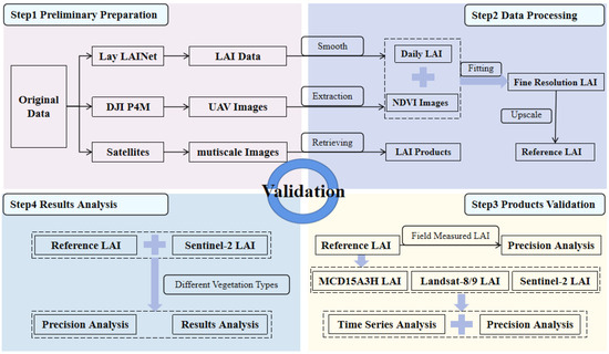
Figure 2.
Technical flowchart.
3.1. Exponential Model Fitting of NDVI-LAI
Vegetation indices (VIs) are typically derived through mathematical combinations of multiple spectral bands, designed to enhance sensitivity to vegetation characteristics while mitigating confounding factors through strategic spectral formulations [46]. Existing studies in this region [36] have demonstrated that the exponential model provides a better fit for the NDVI–LAI relationship compared to linear or other empirical models across this particular study area. Therefore, this study continues to employ an exponential model for LAI-NDVI fitting. Fitted continuous LAINet observational data were collected throughout 2023 with eight synchronized UAV-derived NDVI image acquisitions, with precise estimation of exponential model parameters achieved through leave-one-out cross-validation (LOOCV) and nonlinear least squares curve fitting algorithms. Fine-resolution LAI maps were subsequently generated through inversion of the optimal exponential model selected based on root mean square error minimization criteria. Fine-resolution LAI maps fitting the equations for each growth stage within the study area are summarized in Table 2. Uncertainty was quantified as the product of the mean LAI value from fine-resolution LAI maps and the relative root mean square error (RRMSE) of the retrieval model, to characterize the accuracy of fine-resolution LAI data, defined as follows:
RRMSE represents the relative root mean square error of the inversion value and field-measured LAI for each growth period. In the equation, mean(LAIfield) represents the mean of the field-measured LAI for each growth period, that is the mean of the LAI data obtained from continuous LAINet node observations. LAImean represents the mean of the fine-resolution LAI map within the study area.
Table 2.
Fitting equations for fine-resolution LAI for different time periods.
Table 2.
Fitting equations for fine-resolution LAI for different time periods.
| Date | Fitting Equation | Uncertainty |
|---|---|---|
| 2023/5/3 | LAI = 0.0318 | 0.48 |
| 2023/6/6 | LAI = 0.0141 | 0.57 |
| 2023/6/27 | LAI = 0.1215 | 0.47 |
| 2023/7/17 | LAI = 0.0791 | 0.33 |
| 2023/7/22 | LAI = 0.0592 | 0.40 |
| 2023/8/15 | LAI = 0.1272 | 0.42 |
| 2323/9/5 | LAI = 0.094 | 0.29 |
| 2023/9/15 | LAI = 0.0564 | 0.26 |
Primary error sources of LAI remote sensing products originate from retrieval model errors, input data inaccuracies, scale effects, and ill-posed inversion problems, along with other contributing factors. To quantify the errors introduced by the retrieval model, this study used field-measured LAI measurements to validate fine-resolution LAI maps, and eight fine-resolution LAI maps of the study area were generated through NDVI-LAI model inversion using the equation with minimal root mean square error (RMSE), as shown in Figure 3.
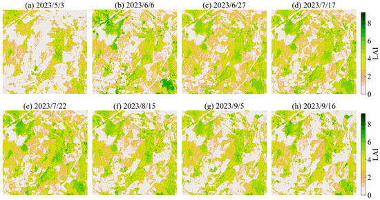
Figure 3.
Fine-resolution LAI data for different periods in the study area.
3.2. Scale Conversion
Substantial research has validated coarse-resolution LAI products using fine-resolution LAI maps [47,48,49,50]. To ensure comparability between fine-resolution LAI maps and medium-to-coarse resolution remote sensing products, scale transformation of the reference maps is required. Liu et al. evaluated the differences between two upscaling approaches, “retrieve-then-average” and “average-then-retrieve”, for assessing scale-dependent discrepancies among remote sensing products at varying resolutions. Generally, the LAI obtained through the “retrieve-then-average” method is considered scale-invariant, whereas the “average-then-retrieve” approach yields scale effects [51]. Building upon fine-resolution LAI maps, this study implemented the “retrieve-then-average” methodology to achieve scale consistency with satellite products through mean aggregation upscaling, ensuring spatial resolution alignment between the reference maps and target product pixels. Subsequently, satellite products and reference LAI maps were compared at the same scale, with product accuracy assessed using metrics including R2, Bias, and RMSE. Temporal consistency was rigorously evaluated through both product-to-reference comparisons and inter-product analyses to evaluate their seasonal variation characteristics across the study area. Furthermore, vegetation type-specific performance assessment was conducted for the high-resolution Sentinel-2 LAI products, examining their accuracy and applicability across distinct land cover classes.
4. Results
4.1. Comparison of Predicted and Measured Values
The field-measured measurements in this study were automatically and continuously acquired by LAINet from May to October 2023, with the raw LAI values subjected to smoothing using a 7-day moving window. By averaging pixel values from fine-resolution LAI maps containing measurement points across multiple time periods, these values served as benchmarks for time-series validation of various LAI products. The comparison between predicted and measured values (Figure 4) demonstrates R2 values ranging from 0.78 to 0.91, Bias values between −0.05 and 0.01, and RMSE values from 0.41 to 0.65. These results confirm the reliability of the fine-resolution LAI data, establishing its suitability as validation benchmarks for LAI products across multiple scales.
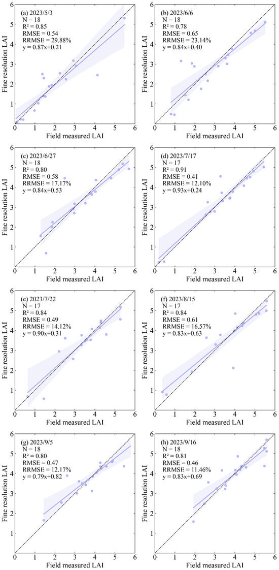
Figure 4.
Comparison of fine-resolution LAI and field-measured LAI data for different time periods.
4.2. Hierarchical Validation of Multi-Scale Products
The fine-resolution LAI maps are upscaled to the scales of the products to be validated in this study, 10 m, 20 m, 30 m, and 500 m, using a mean aggregation method, denoted as Reference LAI_10m, Reference LAI_20m, Reference LAI_30m, and Reference LAI_500m, respectively. These are then compared with the corresponding product scales to obtain the absolute accuracy of the products. Figure 5 and Figure 6 show the accuracy plots of the products in the study area.
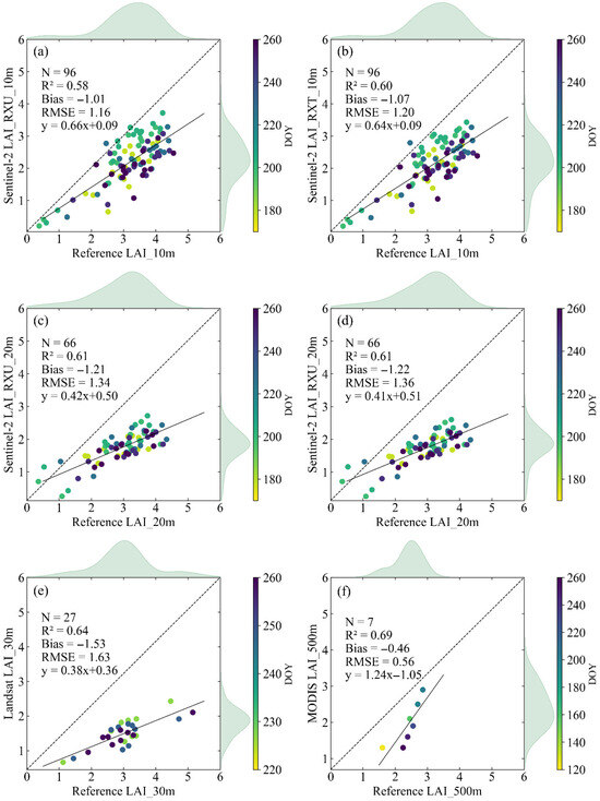
Figure 5.
Comparison of LAI remote sensing products, (a) Sentinel-2 LAI_RXU_10m; (b) Sentinel-2 LAI_RXT_10m; (c) Sentinel-2 LAI_RXU_20m; (d) Sentinel-2 LAI_RXT_20m; (e) Landsat LAI_30m; (f) MODIS LAI_500m with reference LAI maps.
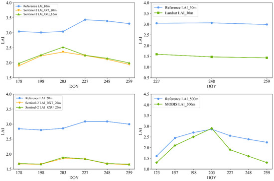
Figure 6.
Temporal consistency validation of LAI remote sensing products with reference LAI.
The comparative analysis between various products and the reference LAI maps (Figure 6) yields the following conclusions: Among Sentinel-2 products, the LAI_RXU_10m demonstrated superior accuracy (RMSE = 1.16) within the study area, followed by LAI_RXT_10m (RMSE = 1.20). The 20 m resolution Sentinel-2 products showed comparatively lower precision, with LAI_RXU_20m yielding an RMSE of 1.34 and LAI_RXT_20m an RMSE of 1.36. Notably, the Landsat LAI_30m product exhibited relatively poorer performance (RMSE = 1.63), significantly underperforming compared to Sentinel-2 LAI products. Of particular importance, despite its coarse spatial resolution (500 m), the MODIS LAI_500m product achieved the lowest RMSE (0.56) among all six evaluated products, demonstrating excellent consistency with the upscaled fine-resolution LAI reference data. These results indicate that the MODIS LAI product outperformed the other five products in this study area, while the Landsat LAI_30m product showed comparatively inferior accuracy characteristics. The respective R2 values for the six products were 0.58, 0.60, 0.61, 0.61, 0.64, and 0.69. The MODIS LAI_500m product achieved the highest value, while the Sentinel-2 LAI_RXU_10m yielded the lowest. Notably, both the Sentinel-2 LAI_RXU_20m and Sentinel-2 LAI_RXT_20m products shared identical R2 values of 0.61. All six products show varying degrees of LAI underestimation, with negative Bias values of −1.01, −1.07, −1.21, −1.22, −1.53, and −0.46. The MODIS LAI_500m product has the smallest deviation, while the largest deviation is seen in the Landsat LAI_30m product.
The two Sentinel-2 images, T48RXU and T48RXT, both cover the study area. Using the SL2P algorithm, the Sentinel-2 LAI products for 10 m and 20 m resolutions are denoted as Sentinel-2 LAI_RXU_10m, Sentinel-2 LAI_RXT_10m, Sentinel-2 LAI_RXU_20m, and Sentinel-2 LAI_RXT_20m. The Sentinel-2 LAI shows moderate consistency with LAINet nodes’ LAI, with negative Bias values and R2 values ranging from 0.58 to 0.61, indicating varying degrees of underestimation. Regardless of whether the resolution is 10 m or 20 m, Sentinel-2 LAI_RXU has better accuracy than Sentinel-2 LAI_RXT. The RMSE for Sentinel-2 LAI_RXT_10m is 1.20, while for Sentinel-2 LAI_RXU_10m, it is 1.16, a reduction of about 3.33%. The RMSE for Sentinel-2 LAI_RXT_20m is 1.36, while for Sentinel-2 LAI_RXU_20m, it is 1.34, a reduction of about 1.47%. Sentinel and LAINet nodes define LAI differently. Sentinel calculates only the green elements of plants, i.e., the Green Area Index (GAI), while LAINet nodes calculates the total Plant Area Index (PAI), which includes both photosynthetically active and non-photosynthetically active elements of the vegetation [24]. Previous studies [38] have shown that Sentinel, based on the SL2P algorithm, achieves high accuracy for crop types but tends to underestimate high LAI values, such as for forests [52]. The observed biases in Sentinel LAI may originate from inherent assumptions within the LAI retrieval algorithm—the Artificial Neural Network (ANN) and Look-Up Tables (LUTs) generated through PROSAIL (PROSPECT+SAIL) radiative transfer model (RTM) simulations, which may lack calibration for local conditions [53]. Therefore, as previous studies have shown, locally calibrated models may be more robust and improve accuracy of products.
The Landsat LAI_30m product demonstrates an RMSE of 1.63, the lowest accuracy among the verification products in this study, with an R2 of 0.64, showing moderate consistency. Like the Sentinel-2 LAI products, it also presents some underestimation of LAI, with a Bias value of −1.53. The Landsat LAI product used in this study, like the Sentinel-2 LAI products, was generated using the SL2P algorithm. The Landsat LAI_30m product demonstrated lower RMSE values compared to the lower-accuracy Sentinel-2 products (LAI_RXT_10m and LAI_RXT_20m) by 35.83% and 19.85%, respectively. When evaluated against the higher-accuracy Sentinel-2 products (LAI_RXU_10m and LAI_RXU_20m), the RMSE reductions were 40.52% and 21.64%, respectively. These results indicate that the SL2P algorithm shows better applicability for Sentinel-2 data in the study area.
4.3. Temporal Consistency Validation
4.3.1. Temporal Consistency Validation of Products with Reference LAI Maps
Figure 7 presents the temporal comparison results between the validated products in this study and the corresponding reference LAI maps at their respective spatial scales. As shown in panel (a), the Sentinel-2 LAI_10m product exhibited a negative correlation with the reference values before DOY 227, followed by a synchronous declining trend in both datasets, with a correlation coefficient (R) reaching 0.99. Overall, the Sentinel-2 LAI_RXU_10m product consistently yielded higher values than Sentinel-2 LAI_RXT_10m across all observation periods. Panel (b) shows that the Sentinel-2 LAI_20m product exhibits good consistency with the reference values, but there is a more significant underestimation overall. Panel (c) demonstrates that the Landsat LAI_30m product follows the same trend as the reference values, but its RMSE is 1.53, indicating lower accuracy compared to the Sentinel-2 LAI products. The MODIS LAI product shows the best consistency with the reference values among the other products, with a correlation coefficient (R) of 0.83. However, previous studies have shown that MODIS LAI products tend to underestimate crop LAI at the end of the growing season [54]. As shown in panel (d), the MODIS LAI severely underestimates LAI values, especially after DOY 203, where the bias is −0.80, compared to −0.21 before DOY 203.
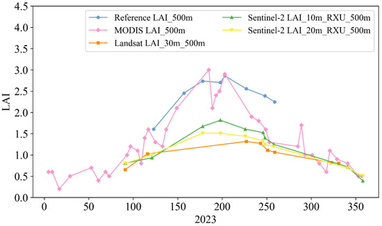
Figure 7.
Cross-validation of temporal consistency of LAI remote sensing products.
4.3.2. Cross-Validation of Temporal Consistency of Remote Sensing Products
Among the validated products, MODIS LAI shows the earliest peak on 4 July. The peaks of Sentinel-2 LAI_10m_RXU and Sentinel-2 LAI_20m_RXU both occur on 17 July, close to the peak period of Reference LAI_500m (22 July). Due to significant data gaps, the peak period of Landsat LAI_30m occurs later, on 15 August. Compared to the reference LAI data, the three high-resolution LAI products severely underestimate vegetation LAI during the growing season, while the coarse-resolution MODIS LAI performs better, showing the highest degree of temporal consistency with the reference LAI.
MODIS LAI, Sentinel-2 LAI, and Landsat-8/9 LAI have 37, 10, and 8 high-quality LAI data points in 2023, respectively. MODIS has the most high-quality data, possibly because the MODIS sensor on the Terra and Aqua satellites can obtain global observation data every 1–2 days, making it easier to obtain cloud-free images of the study area and perform LAI inversion. The revisit period of Landsat-8 and Landsat-9 is 8 days, making it difficult to obtain cloud-free images in the cloudy and foggy southwestern region, resulting in missing source data for LAI inversion. Due to data gaps, the seasonal changes in Landsat-8/9 LAI are not obvious. Although MODIS LAI shows significant seasonal changes, its time-series curve has more abrupt jumps, with some sudden peaks and troughs that do not match the vegetation growth pattern. This may affect the characterization of vegetation phenology, possibly due to the sensitivity of its inversion algorithm to reflectance data noise. In comparison, the Sentinel-2 LAI_RXU curve is the smoothest. Although there are some data gaps, it can still express the characteristics of high LAI in summer and low LAI in winter in the study area.
To quantitatively evaluate the accuracy of the products in the time series, the 500 m daily scale LAI reference data are compared with the LAI products, as shown in Figure 8. Similar to the comparison of LAI products with pixel LAI values, all products show underestimation, with the regression line below the 1:1 line, and MODIS LAI still shows the highest accuracy. However, the least accurate product is Sentinel-2 LAI_20m_RXU, with an RMSE of 1.19, which is 0.05 higher than that of Landsat LAI_30m. The downscaling of LAI generated by the SL2P algorithm to the global product resolution (500 m) includes all errors and noise present in the high-resolution products, which may be one of the reasons for the underestimation of Sentinel-2 LAI and Landsat LAI.
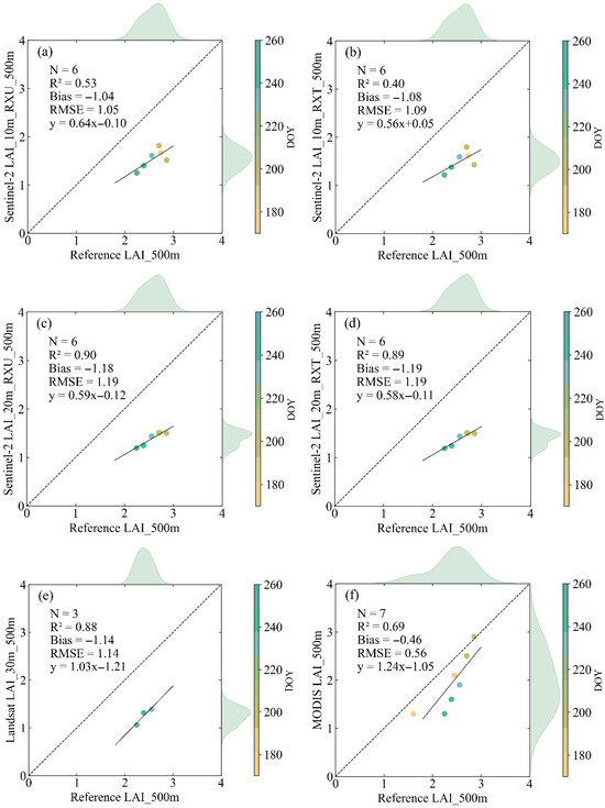
Figure 8.
Comparison of the LAI products with the 500 m daily reference LAI in the study area. (a) Sentinel-2 LAI_10m_RXU_500m; (b) Sentinel-2 LAI_10m _10m_RXT_500m; (c) Sentinel-2 LAI_20m_RXU_500m; (d) Sentinel-2 LAI_20m_RXT_500m; (e) Landsat LAI_30m_500m; (f) MODIS LAI_500m.
4.4. Validation of Sentinel-2 Products for Different Vegetation Types
Surface heterogeneity generally refers to the mixture of multiple land cover types within a given spatial extent [55]. Due to surface heterogeneity within the study area, larger pixel sizes exhibit greater intra-pixel heterogeneity. Under these conditions, validating mixed pixels while distinguishing vegetation types becomes statistically unsound. Therefore, this section focuses exclusively on validating the two 10 m resolution Sentinel-2 products across different vegetation types. The deployment of LAINet instruments covers four vegetation types in the study area. Previous validation exercises have demonstrated that Sentinel-2 LAI frequently meets user requirements over agricultural environments and grassland but underestimates higher LAI values such as those observed over forests [34,49,56,57]. Validation results (Figure 9) demonstrate systematic underestimation across all vegetation types. These findings align with the multi-scale validation results in Section 4.2, where LAI_10m_RXU consistently outperformed LAI_10m_RXT.
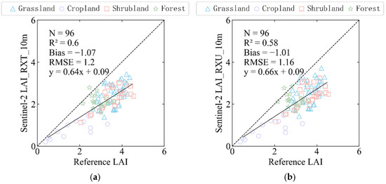
Figure 9.
Validation results of Sentinel-2 LAI_10m products of different vegetation types. (a) Sentinel-2 LAI_RXT_10m; (b) Sentinel-2 LAI_RXU_10m.
Table 3 presents the validation results of the two Sentinel-2 LAI_10m products across different vegetation types. The data reveal systematic underestimation for all vegetation classes, with shrublands exhibiting the most significant bias. Specifically, for shrublands, Sentinel-2 LAI_10m_RXU showed RMSE = 1.29, Bias = −1.21, and R2 = 0.49; Sentinel-2 LAI_10m_RXT showed RMSE = 1.35, Bias = −1.28, and R2 = 0.53.
Table 3.
Sentinel-2 LAI_10m validation results for different vegetation types.
The results show that the accuracy of the product is relatively low, with shrublands exhibiting the most pronounced bias. Both products demonstrated the smallest bias in forested areas, though with relatively low consistency, primarily due to surface heterogeneity and crop characteristics. Taking cropland as an example, LAI values vary significantly across different crop types and growth stages [21]; the poorer performance of LAI products over rice fields has been reported in earlier studies [58]. Therefore, it is essential to fully consider temporal validation and the selection of product pixel size. For subsequent validation of product accuracy across different vegetation types in heterogeneous surface areas, higher-resolution products should be selected to ensure homogeneity within the pixel scale. Additionally, further improvements should be made to enhance the application of retrieval algorithms across different vegetation types.
5. Discussion
In addition to evaluating the accuracy of the products, the causes of product uncertainties are also the focus of researchers’ attention. The uncertainties of LAI products mainly result from data quantification, model imperfection, and scale effect [59]. Due to the spatial scale mismatch between LAI remote sensing products and field-measured data, a fine-resolution LAI map is required as a bridging tool for upscaling. Under conditions of homogeneous land cover, the retrieved value of a coarse-resolution surface parameter should equal the area-weighted average of the fine-resolution retrievals within the corresponding region. Liu et al. [48] found that a systematic underestimation at coarser resolutions, known as the “scale effect”, prevails over most terrestrial vegetated areas, and further demonstrated that the dominant factor contributing to scale effect in remote sensing products is the nonlinearity of the LAI retrieval model, rather than the inherent nonlinearity of the NDVI variable itself. Current empirical statistical methods for estimating LAI are predominantly nonlinear, and such approaches inherently exhibit scale effects. Therefore, during product validation, it is essential to quantify errors induced by scale effects and explore more accurate scale transfer methods.
In terms of inversion models, the high spatial heterogeneity of mountain vegetation may affect the LAI estimation from medium- and coarse-resolution sensors and the quality of global LAI products [60]. Currently, most global-scale LAI remote sensing product generation algorithms do not account for differences between flat and complex topographic areas, and product quality requires extensive ground validation [61]. Future research should focus on optimizing algorithms according to the characteristics of different study regions. In mountainous areas, particular attention should be paid to the influence of topographic factors on inversion accuracy, elevation, slope, aspect, and other topographic factors should be incorporated into the modeling process. Furthermore, topographic correction could be applied to the remote sensing spectral data before using it in the construction of LAI regression models. By comparing the inversion accuracy of LAI before and after topographic correction, the effect and influence of topographic correction can be evaluated [62]. Meanwhile, as this study utilized only a single multispectral sensor for LAI inversion, subsequent research could acquire multiple data from multispectral, hyperspectral, and LiDAR sensors, for model construction and comparison to improve inversion accuracy. Additionally, the accuracy of LAI products varies across different vegetation types; therefore, when validating products over heterogeneous surfaces, the impact of vegetation type differences on the inversion algorithm should be considered. It is also advisable to include various typical ecosystem sample sites rather than limiting product validation to a single type of complex terrain.
6. Conclusions
This study conducted rigorous validation of Sentinel-2, Landsat, and MODIS LAI products. The methodology integrated continuous LAI measurements acquired using an improved MNSM for LAINet deployment with centimeter-resolution UAV multispectral imagery. These datasets enabled generation of fine-resolution LAI maps through NDVI-LAI modeling, which served as scaling intermediaries for validating different resolution LAI products. This study not only reveals performance differences among products over complex terrain but also investigates the consistency of vegetation phenological characteristics across multi-scale products through time-series matching methods, providing scientific guidance for regional-scale LAI product selection and applications. The validation results demonstrate systematic underestimation across all evaluated LAI products. Notably, the coarse-resolution MODIS LAI product exhibited superior accuracy (R2 = 0.69, RMSE = 0.56), outperforming finer-resolution products despite its 500 m spatial resolution. Among Sentinel-2 products, the 10 m resolution LAI_RXU showed better performance (RMSE = 1.16, Bias = −1.01) compared to its 20 m counterpart (RMSE = 1.34, Bias = −1.21). Similarly, the LAI_RXT series displayed resolution-dependent accuracy, with LAI_RXT_10m (RMSE = 1.20, Bias = −1.07) surpassing LAI_RXT_20m (RMSE = 1.36, Bias = −1.22). The Sentinel-2 LAI_RXU product demonstrated superior overall accuracy compared to the Sentinel-2 LAI_RXT product. The Landsat LAI_30m product showed the poorest performance (RMSE = 1.63, Bias = −1.53). The temporal consistency analysis revealed that all products successfully captured the characteristic seasonal dynamics of vegetation LAI in the study area, exhibiting higher values during summer months and lower values in winter. Among them, the MODIS LAI product demonstrated the strongest temporal agreement with the reference LAI data. When evaluated across distinct vegetation types, the Sentinel-2 LAI_10m products exhibited systematic underestimation for all land cover classes, with shrublands displaying the most pronounced bias. A noteworthy observation emerged regarding forested areas: while these regions showed the smallest absolute bias among vegetation types, statistical analysis revealed significantly weaker consistency compared to other land covers. This discrepancy stems primarily from insufficient sampling density (n = 3 forest ESUs), which limits the statistical power to adequately characterize the true LAI distribution in forest ecosystems. The restricted sample size fails to capture the full variability of forest canopy structures, ultimately reducing the explanatory capability of validation models.
Author Contributions
Conceptualization, M.L., W.Y. (Wenping Yu) and D.L.; data curation, D.L., F.S., L.Z., S.W., W.Y. (Wen Yang) and R.Z.; funding acquisition, W.Y. (Wenping Yu) and X.W.; methodology, M.L., W.Y. (Wenping Yu), D.L. and X.W.; software, M.L., D.L. and F.S.; supervision, W.Y. (Wenping Yu) and X.W.; validation, M.L.; writing—original draft, M.L.; writing—review and editing, W.Y. (Wenping Yu), D.L. and X.W. All authors have read and agreed to the published version of the manuscript.
Funding
This study was supported by the National Natural Science Foundation of China (42171338), the Sichuan Science and Technology Program (2023NSFSC1916), and the Fundamental Research Funds for the Central Universities (SWU-KF25023).
Data Availability Statement
The original contributions presented in this study are included in the article; further inquiries can be directed to the corresponding author.
Conflicts of Interest
The authors declare no conflicts of interest.
References
- Chen, J.M.; Black, T.A. Defining Leaf Area Index for Non-Flat Leaves. Plant Cell Environ. 1992, 15, 421–429. [Google Scholar] [CrossRef]
- Badhwar, G.D.; Macdonald, R.B. Satellite-Derived Leaf-Area-Index and Vegetation Maps as Input to Global Carbon Cycle Models-a Hierarchical Approach. Int. J. Remote Sens. 1986, 7, 265–281. [Google Scholar] [CrossRef]
- Stark, S.C.; Leitold, V.; Wu, J.L.; Hunter, M.O.; De Castilho, C.V.; Costa, F.R.C.; McMahon, S.M.; Parker, G.G.; Shimabukuro, M.T.; Lefsky, M.A.; et al. Amazon Forest Carbon Dynamics Predicted by Profiles of Canopy Leaf Area and Light Environment. Ecol. Lett. 2012, 15, 1406–1414. [Google Scholar] [CrossRef] [PubMed]
- Asner, G.P.; Scurlock, J.M.O.; Hicke, J.A. Global Synthesis of Leaf Area Index Observations: Implications for Ecological and Remote Sensing Studies. Glob. Ecol. 2003, 12, 191–205. [Google Scholar] [CrossRef]
- Running, S.W.; Baldocchi, D.D.; Turner, D.P.; Gower, S.T.; Bakwin, P.S.; Hibbard, K.A. A Global Terrestrial Monitoring Network Integrating Tower Fluxes, Flask Sampling, Ecosystem Modeling and EOS Satellite Data. Remote Sens. Environ. 1999, 70, 108–127. [Google Scholar] [CrossRef]
- Bonan, G.B. Land-Atmosphere Interactions for Climate System Models: Coupling Biophysical, Biogeochemical, and Ecosystem Dynamical Processes. Remote Sens. Environ. 1995, 51, 57–73. [Google Scholar] [CrossRef]
- Chen, J.M.; Rich, P.M.; Gower, S.T.; Norman, J.M.; Plummer, S. Leaf Area Index of Boreal Forests: Theory, Techniques, and Measurements. J. Geophys. Res. Atmos. 1997, 102, 29429–29443. [Google Scholar] [CrossRef]
- Justice, C.; Belward, A.; Morisette, J.; Lewis, P.; Privette, J.; Baret, F. Developments in the “validation” of Satellite Sensor Products for the Study of the Land Surface. Int. J. Remote Sens. 2000, 21, 3383–3390. [Google Scholar] [CrossRef]
- Fang, H.; Wang, Y.; Zhang, Y.; Li, S. Long-Term Variation of Global GEOV2 and MODIS Leaf Area Index (LAI) and Their Uncertainties: An Insight into the Product Stabilities. J. Remote Sens. 2021, 2021, 9842830. [Google Scholar] [CrossRef]
- Zeng, Y.; Li, J.; Liu, Q. Global LAI Ground Validation Dataset and Product Validation Framework. Adv. Earth Sci. 2012, 27, 165–174. [Google Scholar]
- Garrigues, S.; Lacaze, R.; Baret, F.; Morisette, J.T.; Weiss, M.; Nickeson, J.E.; Fernandes, R.; Plummer, S.; Shabanov, N.V.; Myneni, R.B.; et al. Validation and Intercomparison of Global Leaf Area Index Products Derived from Remote Sensing Data. J. Geophys. Res. Biogeosci. 2008, 113, 2007JG000635. [Google Scholar] [CrossRef]
- Yin, G.; Li, A.; Jin, H.; Zhao, W.; Bian, J.; Qu, Y.; Zeng, Y.; Xu, B. Derivation of Temporally Continuous LAI Reference Maps through Combining the LAINet Observation System with CACAO. Agric. For. Meteorol. 2017, 233, 209–221. [Google Scholar] [CrossRef]
- Yan, K.; Park, T.; Yan, G.; Liu, Z.; Yang, B.; Chen, C.; Nemani, R.; Knyazikhin, Y.; Myneni, R. Evaluation of MODIS LAI/FPAR Product Collection 6. Part 2: Validation and Intercomparison. Remote Sens. 2016, 8, 460. [Google Scholar] [CrossRef]
- Breda, N.J.J. Ground-Based Measurements of Leaf Area Index: A Review of Methods, Instruments and Current Controversies. J. Exp. Bot. 2003, 54, 2403–2417. [Google Scholar] [CrossRef]
- Fang, H.; Baret, F.; Plummer, S.; Schaepman- Strub, G. An Overview of Global Leaf Area Index (LAI): Methods, Products, Validation, and Applications. Rev. Geophys. 2019, 57, 739–799. [Google Scholar] [CrossRef]
- Yan, G.; Hu, R.; Luo, J.; Weiss, M.; Jiang, H.; Mu, X.; Xie, D.; Zhang, W. Review of Indirect Optical Measurements of Leaf Area Index: Recent Advances, Challenges, and Perspectives. Agric. For. Meteorol. 2019, 265, 390–411. [Google Scholar] [CrossRef]
- Nasahara, K.N.; Muraoka, H.; Nagai, S.; Mikami, H. Vertical Integration of Leaf Area Index in a Japanese Deciduous Broad-Leaved Forest. Agric. For. Meteorol. 2008, 148, 1136–1146. [Google Scholar] [CrossRef]
- Morisette, J.T.; Baret, F.; Privette, J.L.; Myneni, R.B.; Nickeson, J.E.; Garrigues, S.; Shabanov, N.V.; Weiss, M.; Fernandes, R.A.; Leblanc, S.G.; et al. Validation of Global Moderate-Resolution LAI Products: A Framework Proposed within the CEOS Land Product Validation Subgroup. IEEE Trans. Geosci. Remote Sens. 2006, 44, 1804–1817. [Google Scholar] [CrossRef]
- Song, B. Validation of Leaf Area Index Products Over Croplands in China; Aerospace Information Research Institute, Chinese Academy of Sciences: Beijing, China, 2022. [Google Scholar]
- Qu, Y.; Han, W.; Fu, L.; Li, C.; Song, J.; Zhou, H.; Bo, Y.; Wang, J. LAINet—A Wireless Sensor Network for Coniferous Forest Leaf Area Index Measurement: Design, Algorithm and Validation. Comput. Electron. Agric. 2014, 108, 200–208. [Google Scholar] [CrossRef]
- Fang, H.; Zhang, Y.; Wei, S.; Li, W.; Ye, Y.; Sun, T.; Liu, W. Validation of Global Moderate Resolution Leaf Area Index (LAI) Products over Croplands in Northeastern China. Remote Sens. Environ. 2019, 233, 111377. [Google Scholar] [CrossRef]
- Yan, K.; Park, T.; Chen, C.; Xu, B.; Song, W.; Yang, B.; Zeng, Y.; Liu, Z.; Yan, G.; Knyazikhin, Y.; et al. Generating Global Products of LAI and FPAR From SNPP-VIIRS Data: Theoretical Background and Implementation. IEEE Trans. Geosci. Remote Sens. 2018, 56, 2119–2137. [Google Scholar] [CrossRef]
- Verrelst, J.; Camps-Valls, G.; Muñoz-Marí, J.; Rivera, J.P.; Veroustraete, F.; Clevers, J.G.P.W.; Moreno, J. Optical Remote Sensing and the Retrieval of Terrestrial Vegetation Bio-Geophysical Properties—A Review. ISPRS J. Photogramm. Remote Sens. 2015, 108, 273–290. [Google Scholar] [CrossRef]
- Baret, F.; Hagolle, O.; Geiger, B.; Bicheron, P.; Miras, B.; Huc, M.; Berthelot, B.; Niño, F.; Weiss, M.; Samain, O.; et al. LAI, fAPAR and fCover CYCLOPES Global Products Derived from VEGETATION. Remote Sens. Environ. 2007, 110, 275–286. [Google Scholar] [CrossRef]
- Houborg, R.; Soegaard, H.; Boegh, E. Combining Vegetation Index and Model Inversion Methods for the Extraction of Key Vegetation Biophysical Parameters Using Terra and Aqua MODIS Reflectance Data. Remote Sens. Environ. 2007, 106, 39–58. [Google Scholar] [CrossRef]
- Myneni, R.B.; Ramakrishna, R.; Nemani, R.; Running, S.W. Estimation of Global Leaf Area Index and Absorbed Par Using Radiative Transfer Models. IEEE Trans. Geosci. Remote Sens. 1997, 35, 1380–1393. [Google Scholar] [CrossRef]
- Baret, F.; Buis, S. Estimating Canopy Characteristics from Remote Sensing Observations: Review of Methods and Associated Problems. In Advances in Land Remote Sensing; Liang, S., Ed.; Springer: Dordrecht, The Netherlands, 2008; pp. 173–201. ISBN 978-1-4020-6449-4. [Google Scholar] [CrossRef]
- Lemaire, G.; Francois, C.; Soudani, K.; Berveiller, D.; Pontailler, J.; Breda, N.; Genet, H.; Davi, H.; Dufrene, E. Calibration and Validation of Hyperspectral Indices for the Estimation of Broadleaved Forest Leaf Chlorophyll Content, Leaf Mass per Area, Leaf Area Index and Leaf Canopy Biomass. Remote Sens. Environ. 2008, 112, 3846–3864. [Google Scholar] [CrossRef]
- Gitelson, A.A. Wide Dynamic Range Vegetation Index for Remote Quantification of Biophysical Characteristics of Vegetation. J. Plant Physiol. 2004, 161, 165–173. [Google Scholar] [CrossRef]
- Myneni, R.B.; Hall, F.G.; Sellers, P.J.; Marshak, A.L. The Interpretation of Spectral Vegetation Indexes. IEEE Trans. Geosci. Remote Sens. 1995, 33, 481–486. [Google Scholar] [CrossRef]
- Liu, T. Remote Sensing Estimation and Validation of Different Spatial Scales Forest LAI; Northeast Forestry University: Harbin, China, 2019. [Google Scholar]
- Li, D.; Huang, Y.; Xiao, Y.; He, M.; Wen, J.; Li, Y.; Ma, M. Evaluation of the High-Resolution MuSyQ LAI Product over Heterogeneous Land Surfaces. Remote Sens. 2023, 15, 1238. [Google Scholar] [CrossRef]
- Jacquemoud, S.; Baret, F. PROSPECT: A Model of Leaf Optical Properties Spectra. Remote Sens. Environ. 1990, 34, 75–91. [Google Scholar] [CrossRef]
- Djamai, N.; Fernandes, R.; Weiss, M.; McNairn, H.; Goïta, K. Validation of the Sentinel Simplified Level 2 Product Prototype Processor (SL2P) for Mapping Cropland Biophysical Variables Using Sentinel-2/MSI and Landsat-8/OLI Data. Remote Sens. Environ. 2019, 225, 416–430. [Google Scholar] [CrossRef]
- Knight, E.; Kvaran, G. Landsat-8 Operational Land Imager Design, Characterization and Performance. Remote Sens. 2014, 6, 10286–10305. [Google Scholar] [CrossRef]
- Masek, J.G.; Wulder, M.A.; Markham, B.; McCorkel, J.; Crawford, C.J.; Storey, J.; Jenstrom, D.T. Landsat 9: Empowering Open Science and Applications through Continuity. Remote Sens. Environ. 2020, 248, 111968. [Google Scholar] [CrossRef]
- Melnikova, I.; Awaya, Y.; Saitoh, T.; Muraoka, H.; Sasai, T. Estimation of Leaf Area Index in a Mountain Forest of Central Japan with a 30-m Spatial Resolution Based on Landsat Operational Land Imager Imagery: An Application of a Simple Model for Seasonal Monitoring. Remote Sens. 2018, 10, 179. [Google Scholar] [CrossRef]
- Yang, W.; Tan, B.; Huang, D. MODIS Leaf Area Index Products: From Validation to Algorithm Improvement. IEEE Trans. Geosci. Remote Sens. 2006, 44, 1885–1898. [Google Scholar] [CrossRef]
- Jin, H.; Li, A.; Bian, J.; Nan, X.; Zhao, W.; Zhang, Z.; Yin, G. Intercomparison and Validation of MODIS and GLASS Leaf Area Index (LAI) Products over Mountain Areas: A Case Study in Southwestern China. Int. J. Appl. Earth Obs. Geoinf. 2017, 55, 52–67. [Google Scholar] [CrossRef]
- Knyazikhin, Y.; Martonchik, J.V.; Myneni, R.B. Synergistic Algorithm for Estimating Vegetation Canopy Leaf Area Index and Fraction of Absorbed Photosynthetically Active Radiation from MODIS and MISR Data. J. Geophys. Res. Atmos. 1998, 103, 32257–32275. [Google Scholar] [CrossRef]
- Fang, H.; Wei, S.; Liang, S. Validation of MODIS and CYCLOPES LAI Products Using Global Field Measurement Data. Remote Sens. Environ. 2012, 119, 43–54. [Google Scholar] [CrossRef]
- Myneni, R.B.; Hoffman, S.; Knyazikhin, Y.; Privette, J.L.; Glassy, J.; Tian, Y.; Wang, Y.; Song, X. Global Products of Vegetation Leaf Area and Fraction Absorbed PAR from Year One of MODIS Data. Remote Sens. Environ. 2002, 83, 214–231. [Google Scholar] [CrossRef]
- Glenn, E.P.; Huete, A.R.; Nagler, P.L.; Nelson, S.G. Relationship Between Remotely-Sensed Vegetation Indices, Canopy Attributes and Plant Physiological Processes: What Vegetation Indices Can and Cannot Tell Us About the Landscape. Sensors 2008, 8, 2136–2160. [Google Scholar] [CrossRef]
- Brown, L.A.; Meier, C.; Morris, H.; Pastor-Guzman, J.; Bai, G.; Lerebourg, C.; Gobron, N.; Lanconelli, C.; Clerici, M.; Dash, J. Evaluation of Global Leaf Area Index and Fraction of Absorbed Photosynthetically Active Radiation Products over North America Using Copernicus Ground Based Observations for Validation Data. Remote Sens. Environ. 2020, 247, 111935. [Google Scholar] [CrossRef]
- Campos-Taberner, M.; García-Haro, F.J.; Camps-Valls, G.; Grau-Muedra, G.; Nutini, F.; Crema, A.; Boschetti, M. Multitemporal and Multiresolution Leaf Area Index Retrieval for Operational Local Rice Crop Monitoring. Remote Sens. Environ. 2016, 187, 102–118. [Google Scholar] [CrossRef]
- Majasalmi, T.; Rautiainen, M.; Stenberg, P.; Rita, H. Optimizing the Sampling Scheme for LAI-2000 Measurements in a Boreal Forest. Agric. For. Meteorol. 2012, 154–155, 38–43. [Google Scholar] [CrossRef]
- Demarez, V.; Duthoit, S.; Baret, F.; Weiss, M.; Dedieu, G. Estimation of Leaf Area and Clumping Indexes of Crops with Hemispherical Photographs. Agric. For. Meteorol. 2008, 148, 644–655. [Google Scholar] [CrossRef]
- Liu, L. Simulation and Correction of Spatialscaling Effects for Leaf Area Index. J. Remote Sens. 2014, 18, 1158–1168. [Google Scholar] [CrossRef]
- Hu, Q.; Yang, J.; Xu, B.; Huang, J.; Memon, M.S.; Yin, G.; Zeng, Y.; Zhao, J.; Liu, K. Evaluation of Global Decametric-Resolution LAI, FAPAR and FVC Estimates Derived from Sentinel-2 Imagery. Remote Sens. 2020, 12, 912. [Google Scholar] [CrossRef]
- Kganyago, M.; Mhangara, P.; Alexandridis, T.; Laneve, G.; Ovakoglou, G.; Mashiyi, N. Validation of Sentinel-2 Leaf Area Index (LAI) Product Derived from SNAP Toolbox and Its Comparison with Global LAI Products in an African Semi-Arid Agricultural Landscape. Remote Sens. Lett. 2020, 11, 883–892. [Google Scholar] [CrossRef]
- Camacho, F.; Cernicharo, J.; Lacaze, R.; Baret, F.; Weiss, M. GEOV1: LAI, FAPAR Essential Climate Variables and FCOVER Global Time Series Capitalizing over Existing Products. Part 2: Validation and Intercomparison with Reference Products. Remote Sens. Environ. 2013, 137, 310–329. [Google Scholar] [CrossRef]
- Shen, Z.; Liu, Z.; Wu, J. Altitudinal Pattern of Flora on the Eastern of Slope of Mt. Gongga. Biodivers. Sci. 2004, 12, 89. [Google Scholar]
- Campos-Taberner, M.; García-Haro, F.; Busetto, L.; Ranghetti, L.; Martínez, B.; Gilabert, M.A.; Camps-Valls, G.; Camacho, F.; Boschetti, M. A Critical Comparison of Remote Sensing Leaf Area Index Estimates over Rice-Cultivated Areas: From Sentinel-2 and Landsat-7/8 to MODIS, GEOV1 and EUMETSAT Polar System. Remote Sens. 2018, 10, 763. [Google Scholar] [CrossRef]
- Yu, W.; Li, J.; Liu, Q. Extraction and Analysis of Land Cover Heterogeneity over China. Adv. Earth Sci. 2016, 31, 1067–1077. [Google Scholar] [CrossRef]
- Yao, Y.; Liu, Q.; Liu, Q.; Li, X. LAI Inversion Uncertainties in Heterogeneous Surface. J. Remote Sens. 2007, 11, 763–770. [Google Scholar] [CrossRef]
- Brown, L.A.; Ogutu, B.O.; Dash, J. Estimating forest leaf area index and canopy chlorophyll content with Sentinel-2: An evaluation of two hybrid retrieval algorithms. Remote Sens. 2019, 11, 1752. [Google Scholar] [CrossRef]
- Xie, Q.; Dash, J.; Huete, A.; Jiang, A.; Yin, G.; Ding, Y.; Peng, D.; Hall, C.C.; Brown, L.; Shi, Y.; et al. Retrieval of crop biophysical parameters from Sentinel-2 remote sensing imagery. Int. J. Appl. Earth Obs. Geoinf. 2019, 80, 187–195. [Google Scholar] [CrossRef]
- Cheng, Q. Validation and correction of MOD15-LAI using in situ rice LAI in southern China. Commun. Soil Sci. Plant Anal. 2008, 39, 1658–1669. [Google Scholar] [CrossRef]
- Pinty, B.; Andredakis, I.; Clerici, M.; Kaminski, T.; Taberner, M.; Verstraete, M.M.; Gobron, N.; Plummer, S.; Widlowski, J.-L. Exploiting the MODIS albedos with the Two-stream Inversion Package (JRC-TIP): 1. Effective leaf areaindex, vegetation, and soil properties. J. Geophys. Res. 2011, 116, D09105. [Google Scholar] [CrossRef]
- Pasolli, L.; Asam, S.; Castelli, M.; Bruzzone, L.; Wohlfahrt, G.; Zebisch, M.; Notarnicola, C. Retrieval of Leaf Area Index in Mountain grasslands in the Alps from MODIS satellite imagery. Remote Sens. Environ. 2015, 165, 159–174. [Google Scholar] [CrossRef]
- Ma, M.; Che, T.; Li, X.; Xiao, Q.; Zhao, K.; Xin, X. A Prototype Network for Remote Sensing Validation in China. Remote Sens. 2015, 7, 5187–5202. [Google Scholar] [CrossRef]
- Chen, W.; Cao, C. Topographic correction-based retrieval of leaf area index in mountain areas. J. Mt. Sci. 2012, 9, 166–174. [Google Scholar] [CrossRef]
Disclaimer/Publisher’s Note: The statements, opinions and data contained in all publications are solely those of the individual author(s) and contributor(s) and not of MDPI and/or the editor(s). MDPI and/or the editor(s) disclaim responsibility for any injury to people or property resulting from any ideas, methods, instructions or products referred to in the content. |
© 2025 by the authors. Licensee MDPI, Basel, Switzerland. This article is an open access article distributed under the terms and conditions of the Creative Commons Attribution (CC BY) license (https://creativecommons.org/licenses/by/4.0/).