Article

Fire Regions of a Northern Amazonian Landscape Relative to Indigenous Peoples’ Lands

by
Anthony R. Cummings
1,*,
Benjamin J. Kennady
2 and
Adewole M. Adeuga
2
1
Department of Earth and Environmental Sciences, Wesleyan University, Middletown, CT 06439, USA
2
Geospatial Information Sciences, School of Economic, Political and Policy Sciences, University of Texas at Dallas, Richardson, TX 75080, USA
*
Author to whom correspondence should be addressed.
Remote Sens. 2025, 17(19), 3386; https://doi.org/10.3390/rs17193386
Submission received: 23 May 2025 / Revised: 2 September 2025 / Accepted: 1 October 2025 / Published: 9 October 2025

Abstract

Highlights

What are the main findings?
  • There is a strong connection between indigenous peoples’ livelihood practices and fires.
  • Fire distribution patterns allowed for four distinct regions to emerge for Guyana, with the Coastal region hosting the most fires, while the Forest region had the fewest.
What is the implication of the main finding?
  • Fires within the tropical landscapes influenced by indigenous people’s livelihood activities are an important element in maintaining tropical forest cover and diversity.
  • The fire regions uncovered in our work may serve as the basis for examining the size, impacts, and ignition sources of fires rather than ecosystems.

Abstract

Remotely sensed data have been instrumental in improving our understanding of the nature of fires within tropical landscapes. However, most studies have depicted fires in a negative light, highlighting how land-use and land-cover changes make forests more vulnerable to fire damage. In contrast to such fires, indigenous peoples utilize fires as a key part of their livelihood practices, and such relationships have not been extensively examined using remotely sensed data. In this paper, we utilize MODIS Active Fire data to examine the spatial and temporal distribution of fires relative to indigenous lands across Guyana. We employed the DBSCAN clustering algorithm and Voronoi polygons to examine the patterns of fire distribution across the Guyanese landscape. We found that while indigenous territories accounted for approximately 15% of Guyana’s terrestrial landscape, 25% of fires occurred within Amerindian lands, and 71% within 16 km of village boundaries. A strong linear distance decay (R2 = 0.97) was observed between the occurrence of fires and Amerindian village boundaries. Four previously undefined fire regions emerged for Guyana–Coastal, Forest, Forest Edge North, and Forest Edge South–with the Forest Edge regions hosting the second highest number of fires but the highest indigenous peoples’ presence. The spatial distribution of fires relative to each region suggested that Forest Edge indigenous villages had a strong reliance on fires as a part of their toolkit for maintaining the rich ecological processes characteristically observed around their lands.

1. Introduction

Fires are perhaps one of the most important elements that shape the structure and functioning of forested landscapes. In the forested areas of the humid tropics, for example, indigenous and settler communities alike use fires as an agricultural tool [1,2], to prepare land for growing crops and control the regrowth of weeds [3,4,5]. For many communities that lack access to machinery, fertilizer, and pesticides, fires play a critical role in their agricultural management practices [6,7]. In fact, it is estimated that around 300 million people rely on fires as a management tool [8], and hundreds, if not thousands, of cattle ranchers and industrial-scale farmers use fires in their management practices [2]. Fires have been credited for stimulating soil microbial processes [9,10,11,12], promoting seed germination, production, and sprouting of plants [13,14], and altering the structure and composition of soils and vegetation [15,16,17,18]. Fires drive the creation and maintenance of landscape structure, composition, function, and ecological integrity [19,20], influencing the rates and processes of ecological succession and encroachment. Fires have gained increased attention over the past decade or so (see [13,19,20,21,22,23,24,25] for examples). Indigenous peoples within the tropics have derived benefits from fires for centuries [8,19,20,21,22,23,24], yet the question of how fires are distributed relative to their lands remains underexplored.
In the savannah and wetland ecosystems of Amazonia, indigenous peoples use fires to maintain ecosystem services [26,27,28,29], and in traditional livelihood practices, including swidden agriculture [1,30,31,32,33,34,35,36,37,38,39,40,41,42]. In fact, the presence of charcoal or ‘Amazonian dark earths’ (ADE) soils, a product of fires, in Amazonia allows for the conclusion that humans have occupied these forests for centuries [41,43]. ADE soils, created by indigenous peoples hundreds or even thousands of years ago [44], have 70 times more soil organic matter than typical Amazonian soils [45]. Beyond their importance in shaping Amazonian soils, indigenous peoples use fires for domestic activities (cooking, heating, and food preservation), medicinal and healing, hunting and fishing, protection, communication, and craft [30,31]). While indigenous peoples’ fire activities have raised questions on ecological outcomes, non-indigenous actors moving into indigenous spaces have often been associated with undesired ecological outcomes. For instance, selective logging [46,47,48,49], where foresters perforate forests by harvesting or damaging trees, predisposes such forests to fire damage. Further, agriculture and land clearing for cattle farming, where farmers and ranchers deforest land in their drive to prepare for pasture and crops, increase fire fuel load, while reducing the diversity of native plant and animal species [47].
Despite the noted benefits indigenous and other people groups derive, fires are also associated with undesired outcomes for both human and natural systems, including for the global terrestrial, aquatic, and atmospheric systems, and urban settings [2,48,49,50,51,52]. Much of the focus and analysis on fire damage has been skewed towards the predominantly temperate world, with little focus on damage scenarios in tropical landscapes (but see exceptions in [53]). In placing attention to tropical landscapes, ref. [54] summarized the damage of the 1997–1998 El Niño event and its associated fires on the ecosystems of the Brazilian Amazon. In fact, while studies on fire impacts in the tropics have provided significant insights into how both natural and anthropogenic drivers of change impact these landscapes, most of the focus has been at the ecosystem level [53,55,56] with little attention to understanding patterns and distribution of fires at the landscape scale. On the other hand, within the urban settings of the developed world, the focus has been on wildfires and how they impair and endanger human life and property [57,58,59,60]. In urban United States, for instance, the past two to three decades have seen the highest economic costs, including for management and suppression, of fires ever recorded [50]. Events like the Camp Fires in California [61] have also raised concerns for the insurance industry and the costs of fire mitigation and recovery post-fire [62]. For urban-area residents, too, pollutants (e.g., ozone, carbon monoxide, nitrogen dioxide, sulfur dioxide, and particulate matter) emitted by fires impact air quality [63] and raise concerns for human health [64]. Within Earth systems, emissions from fire have direct and significant impacts on atmospheric and biogeochemical cycles and the Earth’s radiative budget [65,66,67,68], and being able to study where fires are distributed can provide insights into where such impacts may likely occur.
Owing to their strong impact on landscapes, fires have long attracted the attention of scholars using remotely sensed data to understand their impacts on landscapes [1,69,70,71,72,73,74]. Remotely sensed data have been used to analyze fires associated with volcanoes [75,76,77], oil and gas flares [78], forests (e.g., [79,80,81,82]), among other situations. Beyond satellite-derived data, unmanned aerial vehicles (UAVs or drones) have also been configured to study fires (see [83,84,85,86]). Remotely sensed datasets have significantly improved our understanding of the nature of fires, including their size, temperature, impacts on forests, and how vegetation recovers post-burning (see [50,85,86,87,88,89]). Indices, such as the normalized burn ratio [74], have been developed to improve our understanding of fire impacts on landscapes.
With the foregoing in mind, this paper’s primary goal was to utilize remotely sensed data to examine fire distribution patterns relative to indigenous peoples’ lands in Northern Amazonia. While most studies on Amazonian fires have been on non-indigenous actors (see [44,45,46,47,51,52]; but see exceptions in [19,20,21,22,23,24,49]), or on fire impacts on specific ecosystems (see [54,55,56]), others, including [33] have highlighted the importance of indigenous peoples-related fires for shaping Amazonia’s forest structure. Further, given that fires have both positive and negative implications for landscapes, being able to determine where studying such impacts will bring the greatest scientific reward is critical. Within the Amazonian context, ref. [51] put forward two conflicting observations: (1) scientists and fire managers in Brazil think farmers indiscriminately use fire, and (2) that most farmers have reasons for why, when, and how they burn. Based on the observations of [51] that farmers know ‘when’ to burn was a primary motivation for this work, as we expected satellite data to provide insights into addressing this question, and that the outcome could provide insights into where fire impacts may be best analyzed.
On the backdrop of the fact that fires associated with climatic events like El Niño trigger an increased number of fires and that most past studies have been at the level of ecosystems within the tropics, two primary questions guided our work. First, using remotely sensed data on fire occurrence, what spatial patterns exist for fire occurrence relative to landscapes influenced by indigenous and non-indigenous peoples? Secondly, given the spatial patterns of fires, what insights do they provide for the “when” fires are burned within indigenous peoples-influenced and non-indigenous spaces? These questions respond directly to [51] observation that farmers know “when” to burn and offer to move beyond the ecosystem level for analyzing fire distribution patterns to fires at the scale of landscapes. We established two objectives to guide this analysis: (1) examine the spatial and temporal relationship between the boundaries of indigenous peoples lands in Guyana and the occurrence of fires as depicted through satellite imagery to understand how fire occurrence relates to indigenous peoples presence, and (2) examine the patterns of fires within the Guyanese landscape to understand how fires relate to indigenous peoples swidden agriculture livelihood practices, the times of year that their swidden agriculture activities are practiced and determine whether climate-related events such as El Niño affect the presence of fires. Our analysis is situated in Guyana, South America, a country where indigenous peoples’ titled lands boundaries are publicly available through spatial databases, and where indigenous peoples’ livelihood practices such as hunting and farming and association with their landscapes, have been documented in the literature. We hypothesized that the presence of indigenous peoples, their landscape realities, and their traditional practices would shape the presence and patterns of fire distribution within their landscapes. More broadly, indigenous peoples in Guyana, like their counterparts in other areas of the Americas, exist within larger communities that reflect colonial histories and realities that collectively affect modern-day fire occurrence. We expected these realities to affect the patterns of fire occurrence and that such patterns would be discernible through spatial analysis of fire occurrence patterns. Our analysis revealed that the presence of indigenous peoples and their significant role in shaping tropical forests may be depicted through fire patterns relative to their lands, and that the occurrence of fires may serve as an important indicator of where future landscape management approaches should incorporate indigenous peoples’ knowledge on fire management.

2. Materials and Methods

2.1. Study Area and Its Fire Sources

To study fire distribution patterns relative to indigenous peoples’ landscapes, a sample of fires from the tropical country of Guyana, South America, was selected. Guyana is South America’s only English-speaking country and lies on the continent’s northeastern coast, bordered by Venezuela, Brazil, and Suriname (Figure 1). Guyana was a suitable site for this study as the country hosts a high population of indigenous and non-indigenous peoples alike that all have connections to fires. The last estimate of Guyana’s population was 746,955 [90], dominated by people of East Indian, African, and mixed heritage. Guyana’s indigenous peoples (referred to as Amerindians) account for around 12% of the national population. Unlike Guyana’s non-Amerindian peoples, who live within or in the suburbs of the nine (9) main municipalities, Amerindians live primarily in 96 legally titled villages and related satellite communities (the term village in the Guyanese context is the legal recognition that indigenous peoples have cultural and spatial ownership over the lands on which they have long-standing historical ties). Nine main Amerindian groups live in Guyana [91], with villages typically located within the forested and forest-edge landscapes of the country. While Amerindians have strong economic connections to the broader Guyanese market economy, a large proportion of the population maintains strong connections to their historical swidden agriculture-influenced landscapes, created by thousands of years of ancestral presence for obtaining subsistence products. To the Amerindian population that practices swidden agriculture, fire is an integral part of their livelihood practices.
Swidden agriculture (see [92,93,94,95,96,97,98,99,100] for an overview) is a crop production system in which the farmer grows crops for periods shorter than the land is fallowed. In this system, an indigenous farmer will cut a manageable portion of forest, typically around 1–2 hectares (see [101]), which is then burned to grow crops. The process of moving from the cleared forest to a farm requires controlled and well-planned fires, and indigenous peoples have developed systems to manage such fires over centuries. In general, indigenous peoples clear the forest in the drier months of the year and burn the felled trees to allow for the cultivation of crops that are synced with the arrival of rains. The highly controlled burning process produces the nutrients necessary for the growth of crops that the farmer and his family will rely upon, including cassava (Manihot esculenta), watermelons, corn, and bananas (see [101]).
While seasonality and events like El Niño were expected to influence fire occurrence, we expected a few country-level realities within the Guyanese landscape would influence the spatial and temporal distribution of fires. First, the distribution of Amerindian villages (see Figure 1) and their associated swidden landscapes will influence where and when fires occur. While the location of Amerindian lands (Figure 1) reflects the legally recognized boundaries of indigenous villages, in reality, the process of recognizing village boundaries is historically ad hoc and may vary from one village to another. By law, a group of Amerindians living on a portion of land for more than twenty-five years has the right to petition the Guyanese state for ownership of said land [102]. However, if the state views a petition favorably, the realities of colonization and the movement of non-indigenous peoples into indigenous influenced landscapes over the years have created complex landscape structures (see [103]). Landscape complexity means that the final boundaries of indigenous villages may not always capture the areas they have traditionally used and requested from the state, including for farming. Furthermore, the development of satellite communities, where a small group of people move away from the larger group towards more suitable farming lands while maintaining connections to the larger group, may result in some members of the village living in areas beyond legally recognized boundaries. Therefore, the location of swidden agriculture plots may not always fall within the confines of the land granted to a village by the state. Scholars [104] have noted that a high proportion of Rupununi Amerindians hunt within their farming areas, with the majority (38%) within 6–12 km, 36% up to 6 km, and 26% greater than 12 km from the center of their villages. While the findings of [104] do not suggest that hunting occurs outside of village boundaries, our analysis expected a correlation between the presence of villages and a distance decay with the occurrence of fires.
The second reality we expected to influence the location and timing of fires in Guyana was the occurrence of the dry and rainy seasons. There are generally two main rainy seasons in Guyana: the May–June rains and the shorter December–January rains. During the May–June rains, large areas of the Guyanese landscape, for example, the Rupununi, become so wet that fires are not typical. We, therefore, expected to observe fewer fires within the landscape during the rainy seasons. Thirdly, beyond indigenous lands, fires may also occur and be triggered by non-indigenous peoples’ activities, as seen elsewhere in Amazonia [47,48,49,100]. In the Guyanese context, sugarcane, rice, and other crop cultivation, ranching, logging, mining, and garbage disposal activities were expected to trigger fires. Sugarcane and rice cultivation-related fires are mainly associated with coastal Guyana, while ranching, logging, and mining-related fires will generally be associated with the forested and forest-edge landscapes of Southern Guyana.

2.2. Data Description

In order to study the distribution of fires across the Guyanese landscape, we used publicly available data as described below.

2.2.1. Fires

The MODIS Active Fire Dataset, located at https://earthdata.nasa.gov/earth-observation-data/near-real-time/firms/active-fire-data, accessed on 30 April 2025, was searched for fires across Guyana. We chose fires covering a sixteen-year period, October 2000–October 2016, as a sample for this analysis. The period was selected as it allowed us to complete a historical analysis of fire occurrence across El Niño periods. The MODIS data are made available to the public for download at a 1 km spatial resolution and provide daily updates on fires. Fire data were downloaded and stored in an ESRI file geodatabase and mapped in ArcGIS for analysis.

2.2.2. Indigenous Peoples’ Lands Location

To analyze the distribution of fires relative to indigenous peoples’ lands, data on Amerindian titled lands were downloaded from the open-source database GuyNode Spatial Data Portal (www.guynode.com) as a shapefile. The shapefile contained polygon(s) for each of the 96 Amerindian villages in Guyana (see Figure 1). We used the presence of an Amerindian village as an indicator and proxy for indigenous peoples’ presence, and by the same logic, the lack of indigenous villages within an area was taken to indicate non-indigenous landscapes.

2.3. Using Spatial and Temporal Distribution of Fires Relative to Indigenous Lands to Create Regions

To study the distribution of fires relative to indigenous lands, we used open-source and ArcGIS tools. The point clustering algorithm, first developed by [105] (see also [106]), Density Based Spatial Clustering of Applications with Noise (DBSCAN) was used to aggregate fire locations based on the distance between points. The DBSCAN algorithm was executed in Python version 3.9.18 using three epsilon (eps) values: 12, 14, and 16 km. The 12 km distance was found to best match the observations of [95] that most indigenous peoples hunted about 12 km away from their village centers. We, therefore, adopted the 12 km distance and assumed that this would be the distance at which most indigenous people’s traditional activities would occur relative to villages. The output clusters from the DBSCAN algorithm were then used to create Voronoi polygons, allowing for the examination of the patterns of clustering associated with the fire occurrence points. The Voronoi polygons allowed for the emergence of fire regions across Guyana. We used a two-step process to create fire regions. First, the distribution of fires within the Voronoi polygons was qualitatively compared using the three epsilon distances (12, 14, and 16 km). The three epsilon distances showed little difference in the patterns of fires, leading to the emergence of primary fire regions. Voronoi polygons with few fires were qualitatively evaluated and merged with polygons having higher numbers of fires based on their distance to a larger cluster. Secondly, the location of indigenous villages relative to Voronoi polygons was used to assess whether there was a relationship between the location of Amerindian lands and fires.
The two-step process resulted in the emergence of four distinct fire regions (see Section 3.1), which were then used to compute and compare the distances between fires and Amerindian villages, as well as non-indigenous areas, across the Guyanese landscape. Non-indigenous areas were mainly along the coast of Guyana, as described later. Computations were completed using the Python library Matplotlib version 3.6.3. The number of fires located within indigenous villages and those located outside the boundary of indigenous villages were compared by computing the Euclidean distance between indigenous land boundaries and fires using the distance calculator (Near Tool) in ArcGIS Pro 3.2. We used the borders of villages, rather than their centers, as data on village centers were not available at the time of analysis. The location of a village’s school was used to represent its center by [104] but these data were not available for our analysis across the Guyanese landscape. In addition to examining the spatial patterns of fire distribution across Guyana, we also examined the time that fires occurred, both relative to each year of data collection (with emphasis on El Niño years) and each of the four fire regions that emerged from our analysis. We further examined the correlation between the occurrence of fires and distance from Amerindian villages using a regression model.

3. Results

The MODIS Active Fire data recorded 28,438 fires across the Guyanese landscape in the ten-year period under consideration. The mean number of fires was 1777 per year with a standard deviation of 607.
The El Niño years accounted for 46.43% of all fires (Table 1) across the study period, with the moderate El Niño of 2002–2003 accounting for the most fires (16.45%). The very strong El Niño period of 2015–2016 accounted for the second-highest proportion of fires (16.25%). Therefore, while there were more fires in the El Niño years, the stronger El Niño did not result in more fires. Of all fires, 25.4% occurred within Amerindian land boundaries, 62% within 12 km, 70.1% within 16 km, and 78% within 22 km (Figure 2). In fact, our analysis revealed a strong linear relationship (R2 = 0.95) between distance and the number of fires that occurred outside the boundary of Amerindian lands.

3.1. Fire Regions

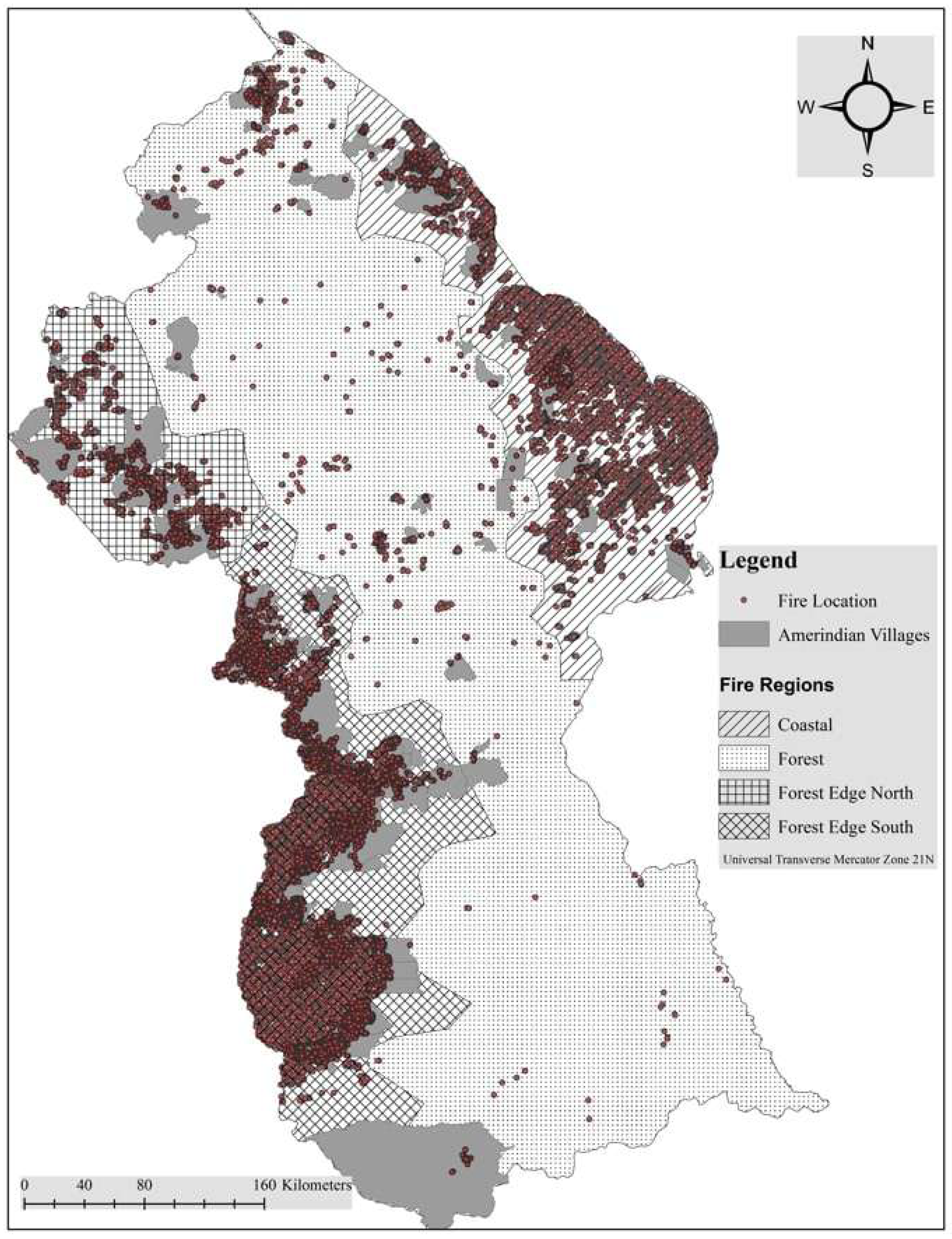
An examination of the DBSCAN cluster outputs and the subsequent Voronoi polygon analysis revealed four main fire regions across Guyana (Figure 3). The first region, referred to here as Coastal, aligns with the distribution of paved roads, coastal villages, sugar cane plantations, rice fields, and other agricultural areas that are crucial to the Guyanese economy. Furthermore, and most critically, the Coastal region intersects with the urban-suburban landscapes of Guyana, where approximately 90% of the population resides. Twenty-two Amerindian villages were associated with the Coastal region, with most situated toward the central part of this region. The second region, referred to here as the Forest region, was situated west of the Coastal region and encompassed the central part of Guyana, extending from the northeast to the southwest of the country (Figure 3). There were twenty-seven Amerindian villages exclusively located within this region, with an additional eight villages having a small portion of their lands in this region (the majority of their lands were in another region). The Forest region separates the Coastal region from the third and fourth regions, which are referred to here as the Forest Edge North and Forest Edge South. The Forest Edge North region is primarily located along the Guyanese border with Venezuela, while the Forest Edge South is situated along the Guyanese border with Brazil. Forty-nine Amerindian villages, nine in the North and forty in the South, were associated with these two regions. One of the villages in the Forest Edge North region has a small area in the Forest region. But when combined, the Forest Edge regions had the highest indigenous peoples’ presence as measured by the number of villages they contained.

3.2. Distribution of Fires Within Regions Relative to Indigenous Lands

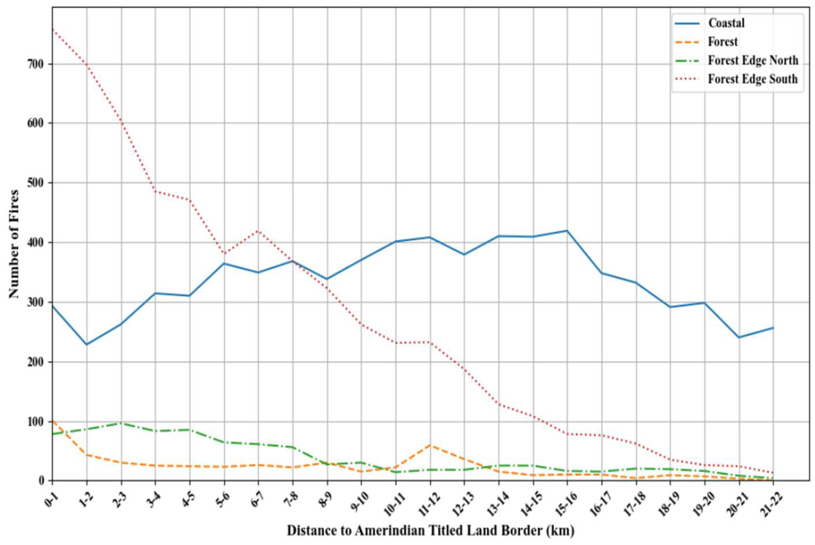
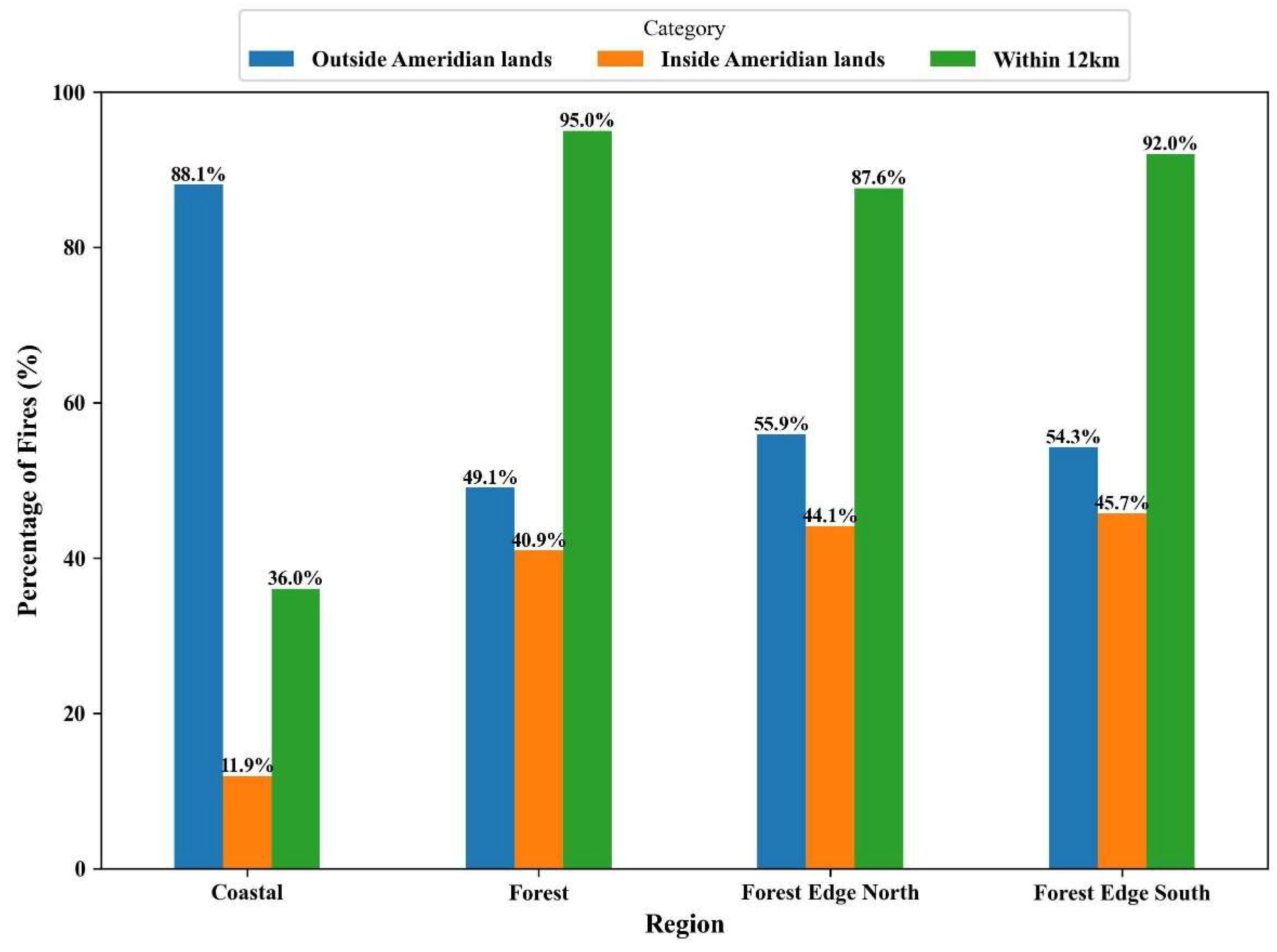
The 28,438 fire locations were distributed primarily between the Coastal (51%) and Forest Edge (44.3%) regions of the Guyanese landscape. The Forest Edge South region accounted for 38.6% of all fires, while the Forest Edge North accounted for 5.6%. The analysis of the number of fires within and outside indigenous village lands showed both predictable and surprising patterns (Figure 4 and Figure 5). Within the Forest Edge regions (north and south), very different patterns of distribution were observed. In the Forest Edge North region, the number of fires peaked at the 2–3 km away from Amerindian villages (Figure 4). For the Forest Edge South region, in contrast, a linear decay in the number of fires as the distance from villages increased was observed. The highest number of fires was observed on the edge of each village and then declined to around 20–22 km away from the villages (Figure 4). The Coastal region showed a gradual increase in the number of fires as the distance from villages increased (Figure 4), peaking between 11 and 12 km and 15–16 km away from villages. The Forest region had the lowest number of fires, with the highest numbers occurring between 1 and 6 km away from villages (Figure 4). For the Forest Edge regions, when the comparison was made between the number of fires inside Amerindian villages and those outside, it was found that 44% occurred within village boundaries (Figure 5). In contrast, 88% of fires within the Coastal region occurred outside of Amerindian lands (Figure 5). In the Forest region, 41% of fires occurred inside Amerindian village boundaries. In the Forest Edge region, 91% of fires occurred within 12 km of Amerindian village boundaries (Figure 4), with 92% in the Forest Edge South region and 87.6% in the Forest Edge North region, respectively. A similar pattern was observed in the Forest region, with 95% of fires detected within 12 km of village boundaries (Figure 5). In contrast, only 36% of fires occurred within 12 km of village boundaries in the Coastal region. Therefore, except for the Coastal region, the 12 km mark away from village boundaries appeared to be important for the distribution of fires relative to indigenous villages (Figure 5). The Coastal region was the only one where fire occurrence appeared more consistent up to the 15–17 km mark and lacked the distinctive distance decay observed up to the 12 km mark in other regions (Figure 4). Non-indigenous peoples and their activities typically trigger fires in the coastal region; hence, the occurrence of fires away from villages followed the pattern we observed.

3.3. Fires in Relation to Time of Year

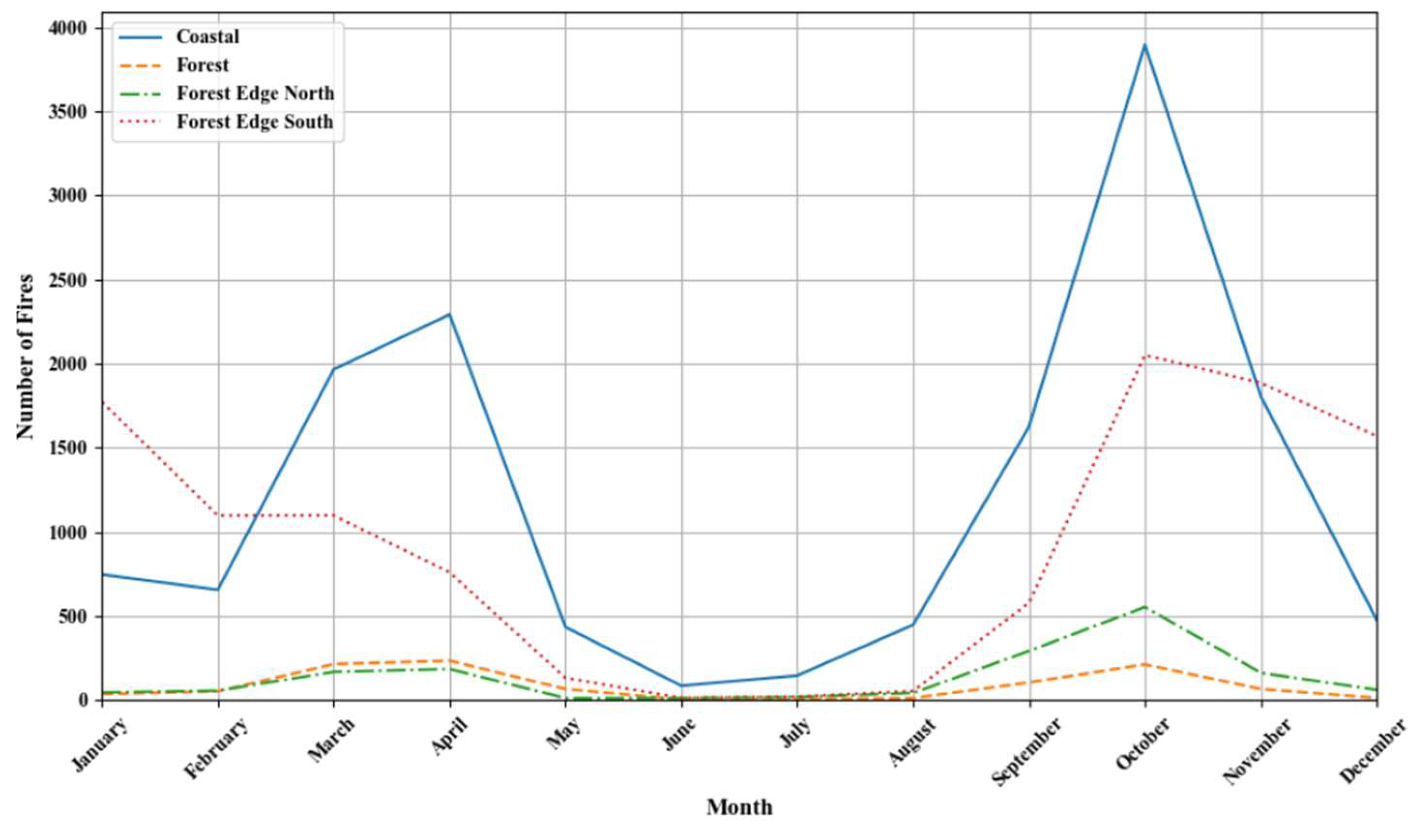
In response to [51] observations that indigenous peoples have patterns of “when” they use fires, our observations (Figure 6) showed some interesting patterns across the four fire regions. In each region (Figure 6), the number of fires observed had a strong connection to the dry and rainy seasons. All regions had the highest number of fires in October, with another smaller peak in April for the Coastal, Forest Edge North, and Forest regions (Figure 6). The highest number of fires occurred during the dry season months of the year, with a notable decrease during the rainy season. The months of October, November, December, March, and April accounted for 69.62% of all fires observed across the Guyanese landscape. The highest number of fires, however, occurred in the month of October, and steadily declined towards the month of February. There was then an increase in March and April. On a month-by-month basis, October accounted for 23.7% of all fires, while March and April each accounted for 12.2%. These observations are consistent with what was expected on swidden agriculture plots, but also, particularly in the case of the Forest Edge regions, the burning of savannah for hunting and cattle-rearing-related activities.
When we analyzed the distribution of fires across the year by the four fire regions, we observed a similar pattern as seen in the Guyanese landscape in the Forest Edges region, but less so in the Forest and Coastal regions within the Amerindian village boundaries. The highest number of fires (20.15%) occurred in October within Amerindian lands, with 14% in April. Overall, the Forest Edge regions showed the most fluctuation in the number of fires within Amerindian villages, with the pattern following the rainy season and the swidden agriculture cycle.
Outside of Amerindian lands, the pattern of fires, although not entirely similar, was more closely aligned with what was observed in the larger Guyanese landscape. Similarly to Amerindian lands, the Forest Edge region exhibited a higher concentration of fires during the months of October to January. The peak number of fires in January was followed by a steady decrease until May. The Forest Edge region showed a marked decrease in the number of fires during the rainy season and a sharp increase from September to October. The Forest region followed a similar pattern as the Coastal region but with much lower counts. The months of June and July accounted for only 1% of all fires across the 10-year period, reflecting the presence of water on the ground during these months.

4. Discussion and Conclusions

This paper’s primary goal was to study the spatial and temporal patterns of fire relative to indigenous peoples’ lands in the tropics. Previous work has examined the distribution of fires within specific ecosystems of the tropics (see, for example, [55]), including the Brazilian Amazon [54]. Here, we presented a different perspective by examining fire distribution relative to indigenous lands. Our analysis considered the Guyanese landscape, which features 96 indigenous villages, and found a strong connection between the presence of indigenous villages and the occurrence of fires. While others have tracked the causes and motivations of fires and the characteristics of the fire regime within tropical landscapes (see the volumes edited by [30,53]), we provide a view of the spatial and temporal patterns surrounding fire occurrence. The MODIS Active Fire dataset allowed us to observe four primary fire regions across Guyana. Three of the four fire regions, Forest, Forest Edge North, and Forest Edge South, coincided with 83% of Amerindian villages. This observation leads one to conclude that fire locations were not a random process but were rather linked to the activities of indigenous peoples within these regions. Our analysis provides some important insights with regard the questions of when and where fires occur, building on the findings of [49], in particular, and provides some validation to the point that indigenous peoples know when and where to burn. Our findings suggest that El Niño events influenced fire patterns, with stronger occurrences during these periods. Whether human or natural ignition sources trigger all fires will remain a question requiring further analysis, and what leads to the increased fires in specific locales needs further investigation.
Yet, the presence of fires within indigenous peoples’ influenced landscapes seemed to follow similar patterns as for other traditional activities, e.g., hunting (see [104]) and keeping plants from which indigenous peoples derive ecosystem services (see [107]). In our case, by using the location of an Amerindian village as a proxy for the indigenous presence, the relationship between indigenous peoples and fires appears well illustrated. Yet, the majority of fires in our study occurred in the Coastal region, an area with a lower indigenous presence than the other regions. The presence of fires in the Coastal region allows for the acknowledgment that other land-use activities occur within the landscape, including commercial agriculture that influences fire distribution. The other land-use activities that may be intersecting with indigenous peoples’ traditional practices are ranching and agricultural activities observed elsewhere in Amazonia (see [2]) primarily in the Forest Edge South and Coastal regions (see Figure 3). Our findings (Figure 2, Figure 3, Figure 4, Figure 5 and Figure 6) indicate that fire regions with the highest indigenous people’s presence (measured by the number of villages) had the most fires within 12 km of village lands, supporting the notion that traditional activities are associated with fires. The connection between indigenous peoples’ landscapes and fires is an observation consistent with the notion that indigenous peoples rely on fires for subsistence livelihood practices (see [1,21,22,23,24,25]). In contrast, the lower proportion (7.96%) of fires inside and within 12 km of indigenous lands in the Coastal (Figure 5) region suggests that these fires may be associated with activities of non-indigenous peoples. Indeed, as the Coastal region accounted for more than 51% of all fires suggests that non-indigenous peoples have an equally strong reliance on fires as do indigenous peoples. These observations raise several questions, including what kind of activities trigger fires within the Coastal and Forest regions of Guyana? What is the difference in the size of fires associated with indigenous versus non-indigenous groups, and what are the ecological impacts of such fires? Future work will seek to better define the boundaries of non-indigenous properties, something that was lacking at the time of writing, and determine the types of activities that are associated with their fires.
Being able to track the activities associated with each of the groups of people that utilized various areas of Guyana’s landscape, their population density, and their relationship to fire were limitations of this current study. It was not possible to ascertain the size of areas burned by fire using optical satellite-borne data due to persistent cloud cover over Guyana. In addition, being able to track where within each region the population is present, population density, and the types of activities they engage in will provide greater insight into understanding the observed patterns of fire. Scholars [51] have provided clues as to the activities that may trigger fires in these areas, but future work needs to ascertain these activities, better map the underlying motivations for them, and understand how they trigger both the spatial and temporal patterns of fires within each region.
Scholars interested in tropical fire ecology have pointed to negative outcomes being associated with non-indigenous actors (see [54]). In our analysis, the lowest number of fires occurred within the Forest region, signaling that uncontrolled forest fires are not a major challenge, at least within this part of the Guyanese landscape. The Forest region recorded the lowest number of fires, despite being the most extensive of the four regions. The exact drivers of fires in the Forest region are unclear at this time, but at this juncture, our results do not appear to mirror observations in other areas of Amazonia, where the activities of ranchers, farmers, and loggers impoverish forests and predispose them to fire (see [32,38,71]). But since indigenous and non-indigenous activities occur within similar spaces in Guyana (see [108]), as is the case for most of Latin America, the regions that emerged from our analysis may serve as lenses to tease apart the impacts of various groups of forest users on fires in their areas of interest. Future analysis will seek to better understand the distribution of fires relative to land-use activities such as gold mining, logging, and ranching, and determine whether they present different spatial and temporal patterns for fire distribution within each of the regions.
The timing or “when” fires occur across Guyana, with most occurring within the drier months of the year, was not a surprising finding. Fires in all regions showed a strong relationship to the seasons and time of year, particularly highlighting the importance of fuel moisture content in leading to ignition. The months of October, November, March, and April had the most fires, a finding that is unsurprising given that these are the driest months of the year. The short rainy season, between December and January, and the presence of water interrupt the burning season in these months and February, and it resumes in March. Some indigenous farmers may have burnt their farms in October or the month before facilitate the growing of crops such as corn and watermelons, and in this case, an incomplete burn will suffice. However, for the growing of the staple cassava crop before the rainy season of May–June, a second burning is necessary to remove remnants of vegetation that were not entirely burned in the October fires. Hence, a second fire in the months of March and April. It is also possible, as observed within the Forest Edge, that some of the fires observed during the latter part of the year may be largely associated with hunting and ranching practices. By burning the savannah, the grass grows back fresh, and indigenous peoples and ranchers alike suggest that this will attract wildlife, such as deer, and act as fodder for livestock (see [3,4,5]). Beyond the annual seasons, El Niño events were associated with the highest numbers of fires. The high number of fires relative to El Niño was not dissimilar from findings in the Brazilian Amazon, where El Niño teleconnections not only triggered droughts and fire events but also led to heavy economic losses (see [54]). The data to track the costs of fire was lacking in our study, but future analysis will examine how El Niño events change fire patterns and impact livelihoods in the Guyanese context.
Perhaps our most important finding is that while other scholars (e.g., [36]) have noted that uncontrolled fires result in major disturbances (see also [51]), our observations suggest that fires within the Guyanese landscape are restricted to the vicinity of indigenous lands, and appear more similar to the moderate disturbance events posited by Sanford et al. [41] that lead to high forest diversity and enhance ecological health. The balance between the population of the coastal Guyana, where 90% of the population reside, and the Forest Edge landscape, which is sparsely populated but has a high indigenous peoples’ population, suggests that while both indigenous and non-indigenous groups rely on fires, indigenous peoples do more so to derive the benefits fires provide, including high levels of biodiversity that support their livelihood activities. Yet, the forests within indigenous peoples’ landscapes have undergone little change, and this raises the question of why this is so. Nevertheless, as climatic and other changes impact the fire regime of the landscape, where both indigenous and non-indigenous communities will be impacted, there is a need to understand what traditional and other activities will be impacted. In this regard, the four fire regions that emerged from our analysis will serve as the basis for examining the implications of such future changes, and will likely provide more meaningful insights than using ecosystems as the basis (see [54]). While ecosystem-level analysis has value for studying ecological processes (see [103]), using fire regions will likely provide more meaningful insights into how people, the ecological processes they rely on, and their activities may, in turn, impact ecological processes. Therefore, future work will assess the spatial extent of fires within regions and describe the sources, causes, sizes, intensities, and periodicities of such fires within the same (see similar ideas in [109]). The fire regions can provide insights into how global-level change processes may impact local systems, and the when, where, and how fires are triggered to bring benefits to humanity, while potentially impairing ecological processes. Similar approaches can be applied to other tropical locales to enhance our understanding of the positive and negative impacts of fires.

Author Contributions

Methodology, B.J.K. and A.M.A.; Formal analysis, B.J.K.; Investigation, B.J.K.; Writing—original draft, A.R.C. All authors have read and agreed to the published version of the manuscript.

Funding

This research was funded by the National Science Foundation grant # 2047940.

Data Availability Statement

The original contributions presented in this study are included in the article. Further inquiries can be directed to the corresponding author.

Acknowledgments

We thank the scientists at the Earth Observing System Data and Information System (EOSDIS) at NASA’s Earth Science Data Systems Program for developing the MODIS Active Fire data and making the dataset freely available for use. We thank four anonymous reviewers who read our manuscript and provided feedback that led to marked improvements in the final paper.

Conflicts of Interest

The authors declare no conflicts of interest.

References

  1. Bowman, D.; Balch, J.K.; Artaxo, P.; Bond, W.J.; Carlson, J.M.; Cochrane, M.A.; Antonio, C.M.; DeFries, S.; Doyle, J.C.; Harrison, S.P.; et al. Fire in the Earth System. Science 2009, 324, 481–484. [Google Scholar] [CrossRef] [PubMed]
  2. Carmenta, R.; Parry, L.; Blackburn, A.; Vermeylen, S.; Barlow, J. Understanding Human-Fire Interactions in Tropical Forest Regions: A Case for Interdisciplinary Research across the Natural and Social Sciences. Ecol. Soc. 2011, 16, 53. [Google Scholar] [CrossRef]
  3. Aragão, L.; Malhi, Y.; Barbier, N.; Lima, A.; Shimabukuro, Y.; Anderson, L.; Saatchi, S. Interactions between Rainfall, Deforestation and Fires during Recent Years in the Brazilian Amazonia. Philos. Trans. R. Soc. Biol. Sci. 2008, 363, 1779–1785. [Google Scholar] [CrossRef] [PubMed]
  4. Eva, H.; Lambin, E. Fires and Land-Cover Change in the Tropics: A Remote Sensing Analysis at the Landscape Scale. J. Biogeogr. 2000, 27, 765–776. [Google Scholar] [CrossRef]
  5. Malingreau, J.; Tucker, C. Largescale Deforestation in the Southeastern Amazon Basin of Brazil. Ambio 1988, 17, 49–55. [Google Scholar]
  6. Pyne, S.J. Fire: A Brief History; University of Washington Press: Seattle, WA, USA, 2001. [Google Scholar]
  7. Kull, C.; Laris, P. Fire Ecology and Fire Politics in Mali and Madagascar. In Tropical Fire Ecology: Climate Change, Land Use and Ecosystem Dynamics; Cochrane, M.A., Ed.; Springer-Praxis Books in Environmental Series; Springer: Chichester, UK, 2009. [Google Scholar]
  8. Brady, N.C. Alternatives to Slash-and-Burn: A Global Imperative. Agric. Ecosyst. Environ. 1996, 58, 3–11. [Google Scholar] [CrossRef]
  9. Borchers, J.; Perry, D. Effects of Prescribed Fire on Soil Organisms. In Natural and Prescribed Fire in Pacific Northwest Forests; Walstad, J.D., Radosevich, S.R., Sandberg, D.V., Eds.; Oregon State University Press: Corvallis, OR, USA, 1990; pp. 143–158. [Google Scholar]
  10. Choromanska, U.; DeLuca, T. Microbial Activity and Nitrogen Mineralization in Forest Mineral Soils Following Heating: Evaluation of Post-Fire Effects. Soil Biol. Biochem. 2002, 34, 263–271. [Google Scholar] [CrossRef]
  11. Poth, M.; Anderson, I.C.; Miranda, H.S.; Miranda, A.C.; Riggan, P.J. The Magnitude and Persistence of Soil NO, N2O, CH4, and CO2 Fluxes from Burned Tropical Savanna in Brazil. Glob. Biochem. Cycles 1995, 9, 503–513. [Google Scholar] [CrossRef]
  12. Wan, S.; Hui, D.; Luo, Y. Fire Effects on Nitrogen Pools and Dynamics in Terrestrial Ecosystems: A Meta-Analysis. Ecol. Appl. 2001, 11, 1349–1365. [Google Scholar] [CrossRef]
  13. Lyon, L.; Stickney, P. Early Vegetal Succession Following Large Northern Rocky Mountain Wildfires. In Proceedings of the Montana Tall Timbers Fire Ecology Conference and Fire and Land Management Symposium, Tall Timbers Research Station, Missoula, MT, USA, 8–10 October 1976. [Google Scholar]
  14. Perez, B.; Moreno, J. Methods for Quantifying Fire Severity in Shrubland-Fires. Plant Ecol. 1998, 139, 91–101. [Google Scholar] [CrossRef]
  15. McHugh, C.; Kolb, T. Ponderosa Pine Mortality Following Fire in Northern Arizona. Int. J. Wildland Fire 2003, 12, 7–22. [Google Scholar] [CrossRef]
  16. Shi, Y.-F.; Shi, S.-H.; Jiang, Y.-S.; Liu, J. A Global Synthesis of Fire Effects on Soil Seed Banks. Glob. Ecol. Conserv. 2022, 36, e02132. [Google Scholar] [CrossRef]
  17. Miller, R.G.; Tangney, R.; Enright, N.J.; Fontaine, J.B.; Merritt, D.J.; Ooi, M.K.J.; Ruthrof, K.X.; Miller, B.P. Mechanisms of Fire Seasonality Effects on Plant Populations. Trends Ecol. Evol. 2019, 34, 1104–1117. [Google Scholar] [CrossRef] [PubMed]
  18. Ryan, K.; Reinhardt, E. Predicting Postfire Mortality of Seven Western Conifers. Can. J. For. Res. 1988, 18, 1291–1297. [Google Scholar] [CrossRef]
  19. Covington, W.; Moore, M. South-Western Ponderosa Pine Forest Structure: Changes since Euro-American Settlement. J. For. 1994, 92, 39–47. [Google Scholar]
  20. Morgan, P.; Hardy, C.C.; Swetnam, T.W.; Rollins, M.G.; Long, D.G. Mapping Fire Regimes across Time and Space: Understanding Coarse and Fine-Scale Fire Patterns. Int. J. Wildland Fire 2001, 10, 329–342. [Google Scholar] [CrossRef]
  21. Neger, C.; Ponce-Calderón, L.P.; Manzo-Delgado, L.D.L.; López-Madrid, M.A. Integrated Fire Management in a Tropical Biosphere Reserve: Achievements and Challenges. Int. J. Disaster Risk Reduct. 2024, 106, 104447. [Google Scholar] [CrossRef]
  22. Smith, W.; Neale, T.; Weir, J.K. Persuasion without Policies: The Work of Reviving Indigenous Peoples’ Fire Management in Southern Australia. Geoforum 2021, 120, 82–92. [Google Scholar] [CrossRef]
  23. Ponce-Calderón, L.P.; Limón-Aguirre, F.; Rodríguez, I.; Rodríguez-Trejo, D.A.; Bilbao, B.A.; Álvarez-Gordillo, G.D.C.; Villanueva-Díaz, J. Fire Management in Pyrobiocultural Landscapes, Chiapas, Mexico. Trop. For. Issues 2022, 61, 53–59. [Google Scholar] [CrossRef]
  24. Bilbao, B.; Mistry, J.; Millán, A.; Berardi, A. Sharing Multiple Perspectives on Burning: Towards a Participatory and Intercultural Fire Management Policy in Venezuela, Brazil, and Guyana. Fire 2019, 2, 39. [Google Scholar] [CrossRef]
  25. Mistry, J.; Schmidt, I.B.; Eloy, L.; Bilbao, B. New Perspectives in Fire Management in South American Savannas: The Importance of Intercultural Governance. Ambio 2019, 48, 172–179. [Google Scholar] [CrossRef] [PubMed]
  26. Eloy, L.; Bilbao, B.A.; Mistry, J.; Schmidt, I.B. From Fire Suppression to Fire Management: Advances and Resistances to Changes in Fire Policy in the Savannas of Brazil and Venezuela. Geogr. J. 2019, 185, 10–22. [Google Scholar] [CrossRef]
  27. Tedim, F.; McCaffrey, S.; Leone, V.; Delogu, G.M.; Castelnou, M.; McGee, T.K.; Aranha, J. What Can We Do Differently about the Extreme Wildfire Problem. In Extreme Wildfire Events and Disasters; Elsevier: Amsterdam, The Netherlands, 2020; pp. 233–263. [Google Scholar] [CrossRef]
  28. Bird, R.B.; Bird, D.W.; Codding, B.F.; Parker, C.H.; Jones, J.H. The “Fire Stick Farming” Hypothesis: Australian Aboriginal Foraging Strategies, Biodiversity, and Anthropogenic Fire Mosaics. Proc. Natl. Acad. Sci. USA 2008, 105, 14796–14801. [Google Scholar] [CrossRef] [PubMed]
  29. McGregor, S.; Lawson, V.; Christophersen, P.; Kennett, R.; Boyden, J.; Bayliss, P.; Liedloff, A.; McKaige, B.; Andersen, A.N. Indigenous Wetland Burning: Conserving Natural and Cultural Resources in Australia’s World Heritage-Listed Kakadu National Park. Hum. Ecol. 2010, 38, 721–729. [Google Scholar] [CrossRef]
  30. Mistry, J.; Bilbao, B.A.; Berardi, A. Community Owned Solutions for Fire Management in Tropical Ecosystems: Case Studies from Indigenous Communities of South America. Philos. Trans. R. Soc. B Biol. Sci. 2016, 371, 1696. [Google Scholar] [CrossRef]
  31. Huffman, M.R. The Many Elements of Traditional Fire Knowledge: Synthesis, Classification, and Aids to Cross-Cultural Problem Solving in Fire Dependent Systems around the World. Ecol. Soc. 2013, 18, 3. [Google Scholar] [CrossRef]
  32. Raish, C.; González-Cabán, A.; Condie, C.J. The Importance of Traditional Fire Use and Management Practices for Contemporary Land Managers in the American Southwest. Glob. Environ. Change Part B Environ. Hazards 2005, 6, 115–122. [Google Scholar] [CrossRef]
  33. Welch, J.; Hetrick, S.; Coimbra, C., Jr.; Brondízio, E. Indigenous Burning as Conservation Practice: Neotropical Savanna Recovery amid Agribusiness Deforestation in Central Brazil. PLoS ONE 2013, 8, e81226. [Google Scholar] [CrossRef]
  34. Williams, G.W. Introduction to Aboriginal Fire Use in North America. Fire Manag. Today 2000, 60, 8–12. [Google Scholar]
  35. Cordeiro, R.C.; Turcq, B.; Suguio, K.; da Silva, A.O.; Sifeddine, A.; Volkmer-Ribeiro, C. Holocene Fires in East Amazonia (Carajás), New Evidences, Chronology and Relation with Paleoclimate. Glob. Planet. Change 2008, 61, 49–62. [Google Scholar] [CrossRef]
  36. Cochrane, M.; Schulze, M. Forest Fires in the Brazilian Amazon. Conserv. Biol. 1998, 12, 948–950. [Google Scholar] [CrossRef]
  37. Cochrane, M.A.; Alencar, A.; Schulze, M.D.; Souza, C.M., Jr.; Nepstad, D.C.; Lefebvre, P.; Davidson, E.A. Positive Feedbacks in the Fire Dynamic of Closed Canopy Tropical Forests. Science 1999, 284, 1832–1835. [Google Scholar] [CrossRef] [PubMed]
  38. Hecht, S.B. Kayapó Savanna Management: Fire, Soils, and Forest Islands in a Threatened Biome. In Amazonian Dark Earths: Wim Sombroek’s Vision; Woods, W.I., Teixeira, W.G., Lehmann, J., Steiner, C., WinklerPrins, A., Rebellato, L., Eds.; Springer Science: New York, NY, USA, 2009; pp. 143–162. [Google Scholar]
  39. Balee, W.; Erickson, C.L. Time and Complexity in Historical Ecology; Columbia University Press: New York, NY, USA, 2006; p. 432. [Google Scholar]
  40. Saldarriaga, J.; West, D. Holocene Fires in the Northern Amazon Basin. Quat. Res. 1986, 26, 358–366. [Google Scholar] [CrossRef]
  41. Sanford, R., Jr.; Saldarriaga, J.; Clark, K.; Uhl, C.; Herrera, R. Amazon Rain-Forest Fires. Science 1985, 227, 53–55. [Google Scholar] [CrossRef] [PubMed]
  42. Woods, W.I.; Teixeira, W.G.; Lehmann, J.; Steiner, C.; WinklerPrins, A.M.G.A. Amazonian Dark Earths: Wim Sombroek’s Vision; Rebellato, L., Ed.; Springer Science: New York, NY, USA, 2009. [Google Scholar]
  43. Wood, W.; Denevan, W. Amazonian Dark Earths: The First Century of Reports. In Amazonian Dark Earths: Wim Sombroek’s Vision; Woods, W.I., Teixeira, W.G., Lehmann, J., Steiner, C., WinklerPrins, A., Rebellato, L., Eds.; Springer Science: New York, NY, USA, 2009; pp. 1–14. [Google Scholar]
  44. Glaser, B.; Woods, W. Amazonian Dark Earths: Explorations in Space and Time; Springer: New York, NY, USA, 2004. [Google Scholar]
  45. Mann, C.C. The Real Dirt on Rainforest Fertility. Science 2002, 297, 920–922. [Google Scholar] [CrossRef]
  46. Uhl, C.; Buschbache, R. A disturbing synergism between cattle ranch burning practices and selective tree harvesting in the Eastern Amazon. Biotropica 1985, 17, 265–268. [Google Scholar] [CrossRef]
  47. Nepstad, D.C.; Verissimo, A.; Alencar, A.; Nobre, C.; Lima, E.; Lefebvre, P.; Schlesinger, P.; Potter, C.; Moutinho, P.; Mendoza, E.; et al. Large-Scale Impoverishment of Amazonian Forests by Logging and Fire. Nature 1999, 398, 505–508. [Google Scholar] [CrossRef]
  48. Souza, C.; Barreto, P., Jr. An Alternative Approach for Detecting and Monitoring Selectively Logged Forests in the Amazon. Int. J. Remote Sens. 2000, 21, 173–179. [Google Scholar] [CrossRef]
  49. Souza, C., Jr.; Silva, L.; Roberts, D.; Firestone, L. Mapping Forest Degradation in the Eastern Amazon from SPOT 4 through Spectral Mixture Models. Remote Sens. Environ. 2003, 87, 494–506. [Google Scholar] [CrossRef]
  50. Lentile, L.B.; Holden, Z.A.; Smith, A.M.; Falkowski, M.J.; Hudak, A.T.; Morgan, P.; Lewis, S.A.; Gessler, P.E.; Benson, N.C. Remote Sensing Techniques to Assess Active Fire Characteristics and Post-Fire Effects. Int. J. Wildland Fire 2006, 15, 319–345. [Google Scholar] [CrossRef]
  51. Mistry, J. Decision Making for Fire Use among Farmers in Savannas: An Exploratory Study in the Distrito Federal, Central Brazil. J. Environ. Manag. 1998, 54, 321–334. [Google Scholar] [CrossRef]
  52. Sunar, F.; Ozkan, C. Forest Fire Analysis with Remote Sensing Data. Int. J. Remote Sens. 2001, 22, 2265–2277. [Google Scholar] [CrossRef]
  53. Cochrane, M.A. Fire in the Tropics; Springer-Praxis Books in Environmental Series; Springer: Chichester, UK, 2009. [Google Scholar]
  54. Cochrane, M.A. Tropical Fire Ecology: Climate Change, Land Use and Ecosystem Dynamics. In Fire, Land Use, Land Cover Dynamics, and Climate Change in the Brazilian Amazon; Springer-Praxis Books in Environmental Series; Springer: Chichester, UK, 2009. [Google Scholar]
  55. Bilbao, B.; Leal, A.; Méndez, C.; Delgado-Cartay, M.D. Tropical Fire Ecology: Climate Change, Land Use and Ecosystem Dynamics. In The Role of Fire in the Vegetation Dynamics of Upland Savannas of the Venezuelan Guayana; Cochrane, M.A., Ed.; Springer-Praxis Books in Environmental Series; Springer: Chichester, UK, 2009; pp. 451–480. [Google Scholar]
  56. Miranda, H.S.; Sato, M.N.; Neto, W.N.; Aires, F.S. Tropical Fire Ecology: Climate Change, Land Use and Ecosystem Dynamics. In Fires in the Cerrado, the Brazilian Savanna; Cochrane, M.A., Ed.; Springer-Praxis Books in Environmental Series; Springer: Chichester, UK, 2009. [Google Scholar]
  57. Bradshaw, W.G. Protection in the Urban/Wildland Interface: Who Plays What Role? Fire Technol. 1988, 24, 195–203. [Google Scholar] [CrossRef]
  58. Beebe, G.S.; Omi, P.N. Wildland Burning: The Perception of Risk. J. For. 1993, 91, 19–24. [Google Scholar] [CrossRef]
  59. Butler, B.; Cohen, J. Firefighter Safety Zones: A Theoretical Model Based on Radiative Heating. Int. J. Wildland Fire 1998, 8, 73–77. [Google Scholar] [CrossRef]
  60. Cohen, J.D. Preventing Disaster: Home Ignitability in the Wildland-Urban Interface. J. For. 2000, 98, 15–21. [Google Scholar] [CrossRef]
  61. Wootson, C.R. The Deadliest, Most Destructive Wildfire in California’s History Has Finally Been Contained. 2018. Available online: https://www.washingtonpost.com/nation/2018/11/25/camp-fire-deadliest-wildfire-californias-history-has-been-contained/?utm_term=.5efcf9fd4cbc (accessed on 29 April 2025).
  62. Dobush, G. Losses from California Wildfires Expected to Top $19 Billion, Further Stressing an Already Struggling Insurance Industry. 2018. Available online: http://fortune.com/2018/11/12/california-wildfire-camp-fire-insurance-cost/ (accessed on 29 April 2025).
  63. Hardy, C.C.; Ottmar, R.D.; Peterson, J.L.; Core, J.E.; Seamon, P. Smoke Management Guide for Prescribed and Wildland Fire; USDA National Wildfire Coordination Group Publication PMS: Ogden, UT, USA, 2001.
  64. Brauer, M. Health Impacts of Biomass Air. In Health Guidelines for Vegetation Fire Events Background Papers; Goh, K.-T., Schwela, D., Goldammer, J.G., Simpson, O., Eds.; WHO/UNEP/WMO: Singapore, 1999; pp. 186–254. [Google Scholar]
  65. Crutzen, P.; Andreae, M. Biomass Burning in the Tropics: Impact on Atmospheric Chemistry and Biogeochemical Cycles. Science 1990, 250, 1669. [Google Scholar] [CrossRef]
  66. McNaughton, S.J.; Stronach, N.R.H.; Georgiadis, N.J. Combustion in Natural Fires and Global Emissions Budgets. Ecol. Appl. 1998, 8, 464–468. [Google Scholar] [CrossRef]
  67. Andreae, M.; Merlet, P. Emission of Trace Gases and Aerosols from Biomass Burning. Glob. Biochem. Cycles 2001, 15, 955–966. [Google Scholar] [CrossRef]
  68. Smith, A.M.S.; Wooster, M.J.; Drake, N.A.; Perry, G.L.W.; Dipotso, F.M. Fire in African Savanna: Testing the Impact of Incomplete Combustion of Pyrogenic Emission Estimates. Ecol. Appl. 2005, 15, 1074–1082. [Google Scholar] [CrossRef]
  69. Chuvieco, E.; Aguado, I.; Yebra, M.; Nieto, H.; Salas, J.; Martín, M.P.; Zamora, R. Development of a Framework for Fire Risk Assessment Using Remote Sensing and Geographic Information System Technologies. Ecol. Model. 2010, 221, 46–58. [Google Scholar] [CrossRef]
  70. Diaz-Delgado, R.; Lloret, F.; Pons, X. Influence of Fire Severity on Plant Regeneration by Means of Remote Sensing Imagery. Int. J. Remote Sens. 2003, 24, 1751–1763. [Google Scholar] [CrossRef]
  71. Hernandez-Leal, P.A.; Arbelo, M.; Gonzalez-Calvo, A. Fire risk assessment using satellite data. Adv. Space Res. 2006, 37, 741–746. [Google Scholar] [CrossRef]
  72. Keane, R.E.; Drury, S.A.; Karau, E.C.; Hessburg, P.F.; Reynolds, K.M. A Method for Mapping Fire Hazard and Risk across Multiple Scales and Its Application in Fire Management. Ecol. Model. 2010, 221, 2–18. [Google Scholar] [CrossRef]
  73. Robinson, J.M. Fire from Space: Global Fire Evaluation Using Infrared Remote Sensing. Int. J. Remote Sens. 1991, 12, 3–24. [Google Scholar] [CrossRef]
  74. Roy, D.P.; Boschetti, B.; Trigg, S.N. Remote Sensing of Fire Severity: Assessing the Performance of the Normalized Burn Ratio. IEEE Geosci. Remote Sens. Lett. 2006, 3, 112–116. [Google Scholar] [CrossRef]
  75. Carn, S.A.; Clarisse, L.; Prata, A.J. Multi-Decadal Satellite Measurements of Global Volcanic Degassing. J. Volcanol. Geotherm. Res. 2016, 311, 99–134. [Google Scholar] [CrossRef]
  76. Naranjo, M.F.; Ebmeier, S.K.; Vallejo, S.; Ramón, P.; Mothes, P.; Biggs, J.; Herrera, F. Mapping and Measuring Lava Volumes from 2002 to 2009 at El Reventador Volcano, Ecuador, from Field Measurements and Satellite Remote Sensing. J. Appl. Volcanol. 2016, 5, 8. [Google Scholar] [CrossRef]
  77. Toyos, G.; Mingari, L.; Pujol, G.C.; Villarosa, G. Investigating the Nature of an Ash Cloud Event in Southern Chile Using Remote Sensing: Volcanic Eruption or Resuspension? Remote Sens. Lett. 2017, 8, 146–155. [Google Scholar] [CrossRef]
  78. Elvidge, C.D.; Zhizhin, M.; Baugh, K.; Hsu, F.C.; Ghosh, T. Methods for Global Survey of Natural Gas Flaring from Visible Infrared Imaging Radiometer Suite Data. Energies 2016, 9, 14. [Google Scholar] [CrossRef]
  79. Liu, Z.; Yang, J.; Dwomoh, F. Mapping Recent Burned Patches in Siberian Larch Forest Using Landsat and MODIS Data. Eur. J. Remote Sens. 2016, 49, 861–887. [Google Scholar] [CrossRef]
  80. Matricardi, E.A.T.; Skole, D.L.; Pedlowski, M.A.; Chomentowski, W.; Fernandes, L.C. Assessment of Tropical Forest Degradation by Selective Logging and Fire Using Landsat Imagery. Remote Sens. Environ. 2010, 114, 1117–1129. [Google Scholar] [CrossRef]
  81. Morton, D.C.; DeFries, R.S.; Nagol, J.; Souza, C.M.; Kasischke, E.S.; Hurtt, G.C.; Dubayah, R. Mapping Canopy Damage from Understory Fires in Amazon Forests Using Annual Time Series of Landsat and MODIS Data. Remote Sens. Environ. 2011, 115, 1706–1720. [Google Scholar] [CrossRef]
  82. Roy, D.; Kumar, S. Multi-Year MODIS Active Fire Type Classification over the Brazilian Tropical Moist Forest Biome. Int. J. Digit. Earth 2017, 10, 54–84. [Google Scholar] [CrossRef]
  83. Allison, R.S.; Johnston, J.M.; Craig, G.; Jennings, S. Airborne Optical and Thermal Remote Sensing for Wildfire Detection and Monitoring. Sensors 2016, 16, 1310. [Google Scholar] [CrossRef]
  84. Ghamry, K.; Zhang, Y. Fault-Tolerant Cooperative Control of Multiple UAVs for Forest Fire Detection and Tracking Mission. In Proceedings of the Conference on Control and Fault-Tolerant Systems, SysTol, Barcelona, Spain, 7–9 September 2016; pp. 133–138. [Google Scholar]
  85. Ghamry, K.A.; Kamel, M.A.; Zhang, Y. Cooperative Forest Monitoring and Fire Detection Using a Team of UAVs-UGVs. In Proceedings of the International Conference on Unmanned Aircraft Systems, ICUAS, Arlington, VA, USA, 7–10 June 2016; pp. 1206–1211. [Google Scholar]
  86. Yuan, C.; Liu, Z.; Zhang, Y. Vision-Based Forest Fire Detection in Aerial Images for Firefighting Using UAVs. In Proceedings of the 2016 International Conference on Unmanned Aircraft Systems (ICUAS), Arlington, VA, USA, 7–10 June 2016; pp. 1200–1205. [Google Scholar]
  87. Chuvieco, E.; Congalton, R.G. Application of Remote Sensing and Geographic Information Systems to Forest Fire Hazard Mapping. Remote Sens. Environ. 1989, 29, 147–159. [Google Scholar] [CrossRef]
  88. Meng, R.; Dennison, P.E.; D’Antonio, C.M.; Moritz, M.A. Remote Sensing Analysis of Vegetation Recovery Following Short-Interval Fires in Southern California Shrublands. PLoS ONE 2014, 9, e110637. [Google Scholar] [CrossRef] [PubMed]
  89. Robinson, D. Development of External Regeneration Models for FVS: Another Wrench in the Toolkit. In Proceedings of the 2008 Third Forest Vegetation Simulator Conference, Fort Collins, CO, USA, 13–15 February 2007; Havis, R.N., Crookston, N.L., Eds.; US Department of Agriculture, Forest Service, Rocky Mountain Research Station: Fort Collins, CO, USA, 2008; pp. 225–234. [Google Scholar]
  90. Statistics, G.B. Population & Housing Census. Bureau of Statistics, Government of Guyana. 2012. Available online: https://statisticsguyana.gov.gy/ (accessed on 29 April 2025).
  91. Bulkan, J. The Struggle for Recognition of the Indigenous Voice: Amerindians in Guyanese Politics. Round Table 2013, 102, 367–380. [Google Scholar] [CrossRef]
  92. Beckerman, S. Does the Swidden Ape the Jungle? Hum. Ecol. 1983, 11, 1–12. [Google Scholar] [CrossRef]
  93. Denevan, W. Semi-Intensive Pre-European Cultivation and the Origins of Anthropogenic Dark Earth in Amazonia. In Amazonian Dark Earths: Explorations in Space and Time; Glaser, B., Woods, W., Eds.; Springer: New York, NY, USA, 2004; pp. 135–143. [Google Scholar]
  94. Denevan, W.M. Pre-European Forest Cultivation in Amazonia. In Time and Complexity in Historical Ecology; Balee, W., Erickson, C.L., Eds.; Columbia University Press: New York, NY, USA, 2006; pp. 153–165. [Google Scholar]
  95. Dove, M. Theories of Swidden Agriculture and the Political Economy of Ignorance. Agrofor. Syst. 1983, 1, 85–99. [Google Scholar] [CrossRef]
  96. Fox, J.; Fujita, Y.; Ngidang, D.; Peluso, N.; Potter, L.; Sakuntaladewi, N.; Sturgeon, J.; Thomas, D. Policies, Political-Economy, and Swidden in Southeast Asia. Hum. Ecol. 2009, 37, 305–322. [Google Scholar] [CrossRef]
  97. Hecht, S.; Anderson, A.; May, P. The Subsidy from Nature: Shifting Cultivation, Successional Palm Forests, and Rural Development. Hum. Organ. 1988, 47, 25–35. [Google Scholar] [CrossRef]
  98. Mertz, O.; Padoch, C.; Fox, J.; Cramb, R.; Leisz, S.J.; Lam, N.T.; Vien, T.D. Swidden Changes in Southeast Asia: Understanding Causes and Consequences. Hum. Ecol. 2009, 37, 259–264. [Google Scholar] [CrossRef]
  99. Posey, D.A. Indigenous Management of Tropical Forest Ecosystems: The Case of the Kayapó Indians of the Brazilian Amazon. Agrofor. Syst. 1985, 3, 139–158. [Google Scholar] [CrossRef]
  100. Uhl, C.; Clark, H.; Clark, K.; Maquirino, P. Successional Patterns Associated with Slash and Burn Agriculture in the Upper Rio Negro Region of the Amazon Basin. Biotropica 1982, 14, 249–254. [Google Scholar] [CrossRef]
  101. Cummings, A.R.; Karale, Y.; Cummings, G.R.; Hamer, E.; Moses, P.; Norman, Z.; Captain, V. UAV-Derived Data for Mapping Change on a Swidden Agriculture Plot: Preliminary Results from a Pilot Study. Int. J. Remote Sens. 2017, 38, 2066–2082. [Google Scholar] [CrossRef]
  102. Act No. 6 of 2006. Amerindian Act 2006. Parliament of Guyana. Available online: https://parliament.gov.gy/documents/acts/4680-act_no_6_of_2006.pdf (accessed on 29 April 2025).
  103. Cummings, A.R.; Read, J.M.; Fragoso, J.M.V. Implications of Forest Type and Landscape Diversity on the Sustainability of Ecosystem Services Provided by Northern Amazonia’s Multiple-Use Tree Species. Landsc. Ecol. 2018, 33, 423–438. [Google Scholar] [CrossRef]
  104. Read, J.M.; Fragoso, J.M.V.; Silvius, K.M.; Luzar, J.B.; Overman, H.; Cummings, A.R.; Giery, S.T.; de Oliveira, L.F.B. Space, Place, and Hunting Patterns among Indigenous Peoples of the Guyanese Rupununi Region. J. Lat. Am. Geogr. 2010, 9, 213–243. [Google Scholar] [CrossRef]
  105. Ester, E.; Kriegel, H.P.; Sander, J.; Xu, X. A Density-Based Algorithm for Discovering Clusters in Large Spatial Databases with Noise. Kdd 1996, 96, 226–231. [Google Scholar]
  106. Xiang, Z.; Yu, Z. Voronoi-Clustering for Plane Data. In Proceedings of the 10th International Conference on Natural Computation, ICNC, Xiamen, China, 19–21 August 2014; pp. 759–763. [Google Scholar] [CrossRef]
  107. Sivasailam, A.; Cummings, A. Does the Location of Amerindian Communities Provide Signals About the Spatial Distribution of Tree and Palm Species? In Advances in Advances in Geocomputation-Geocomputation 2015—The 13th International Conference; Griffith, D.A., Chun, Y., Dean, J.D., Eds.; Springer: Cham, Switzerland, 2017; pp. 169–179. [Google Scholar]
  108. Colchester, M. Guyana: Fragile Frontier; Forest Peoples Programme; World Rainforest Movement: Gloucestershire, UK, 1997. [Google Scholar]
  109. Lafon, C.W.; Hoss, J.A.; Grissino-Mayer, H.D. The Contemporary Fire Regime of the Central Appalachian Mountains and Its Relation to Climate. Phys. Geogr. 2005, 26, 126–146. [Google Scholar] [CrossRef]
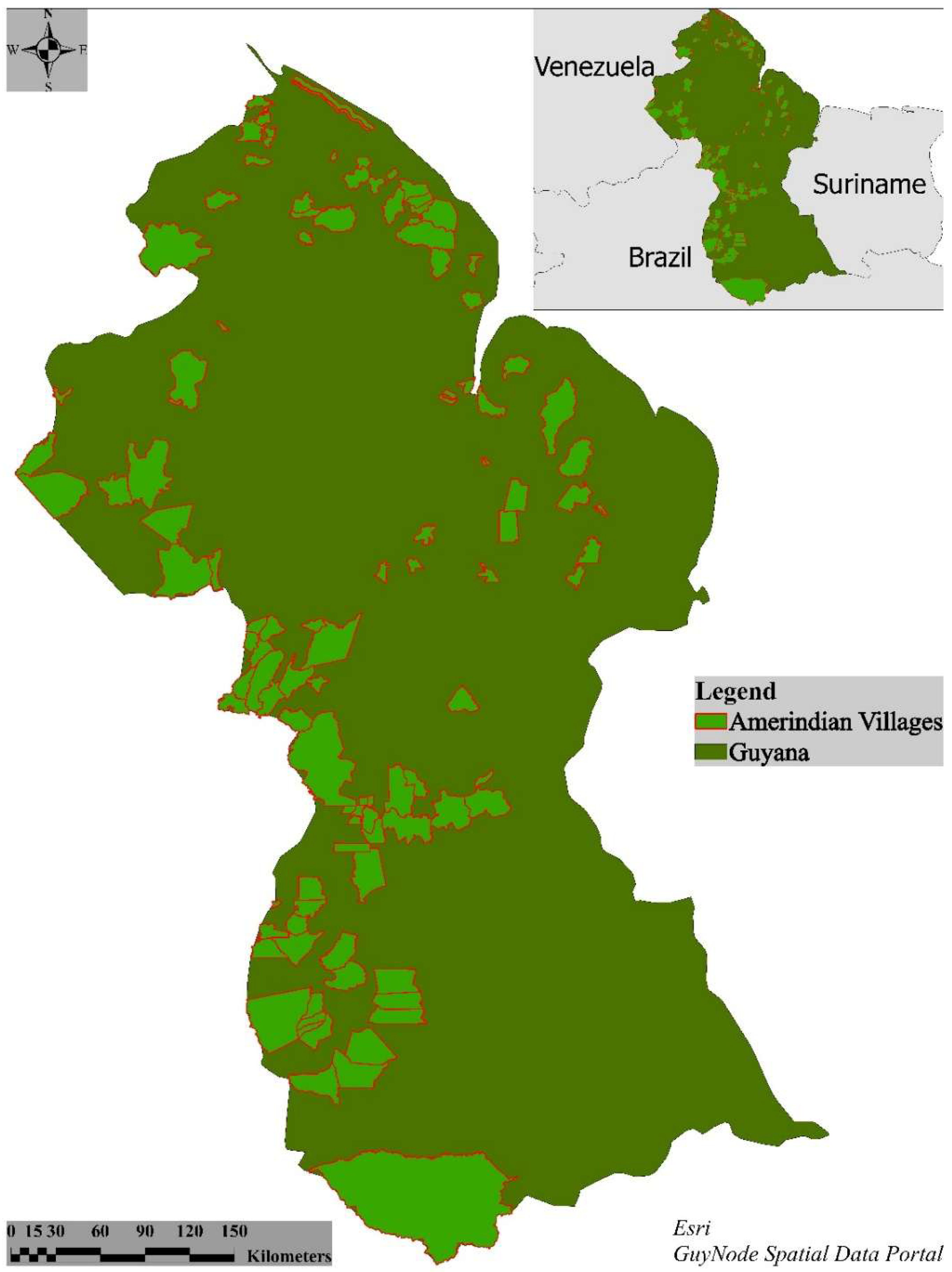
Figure 1. Study area and the distribution of Amerindian lands across the landscape. Data for the map are from ESRI and GuyNode Spatial Data Portal.
Remotesensing 17 03386 g001
Figure 2. The distance of fires relative to Amerindian lands across the Guyanese landscape.
Remotesensing 17 03386 g002
Figure 3. The derived clusters from the analysis of fire distribution and the four fire regions that emerged for the Guyanese landscape.
Remotesensing 17 03386 g003
Figure 4. The distribution of fires relative to Amerindian lands in each of the four fire regions.
Remotesensing 17 03386 g004
Figure 5. Percentage of fires relative to Amerindian lands in each of the four fire regions.
Remotesensing 17 03386 g005
Figure 6. The count of fires per month across the four fire regions.
Remotesensing 17 03386 g006
Table 1. The number of fires reported over the study period relative to El Niño and La Niña events. Moderate and strong El Niño years are bolded.
YearNumber of FiresPercentage of TotalIntensity of El Niño/La Niña
2000840.29Weak La Niña
20019663.39Weak La Niña
200213424.71Moderate El Niño
2003335111.75Moderate El Niño
200418936.64Weak El Niño
200515815.54Weak El Niño
200615415.40Weak El Niño
200713744.82Weak El Niño
200811774.13Weak La Niña
200921417.51Moderate El Niño
201017756.22Moderate El Niño/Strong La Niña
201113254.65Moderate La Niña
201219646.89Moderate La Niña
201314985.25Absent
201418766.58Weak El Niño
201528389.95Very Strong El Niño
201617966.30Very Strong El Niño
Data from https://ggweather.com/enso/oni.htm (accessed on 30 April 2025).
Disclaimer/Publisher’s Note: The statements, opinions and data contained in all publications are solely those of the individual author(s) and contributor(s) and not of MDPI and/or the editor(s). MDPI and/or the editor(s) disclaim responsibility for any injury to people or property resulting from any ideas, methods, instructions or products referred to in the content.