Detection of Small-Scale Potential Landslides in Vegetation-Covered Areas of the Hengduan Mountains Using LT-1 Imagery: A Case Study of the Luding Seismic Zone
Abstract
Highlights
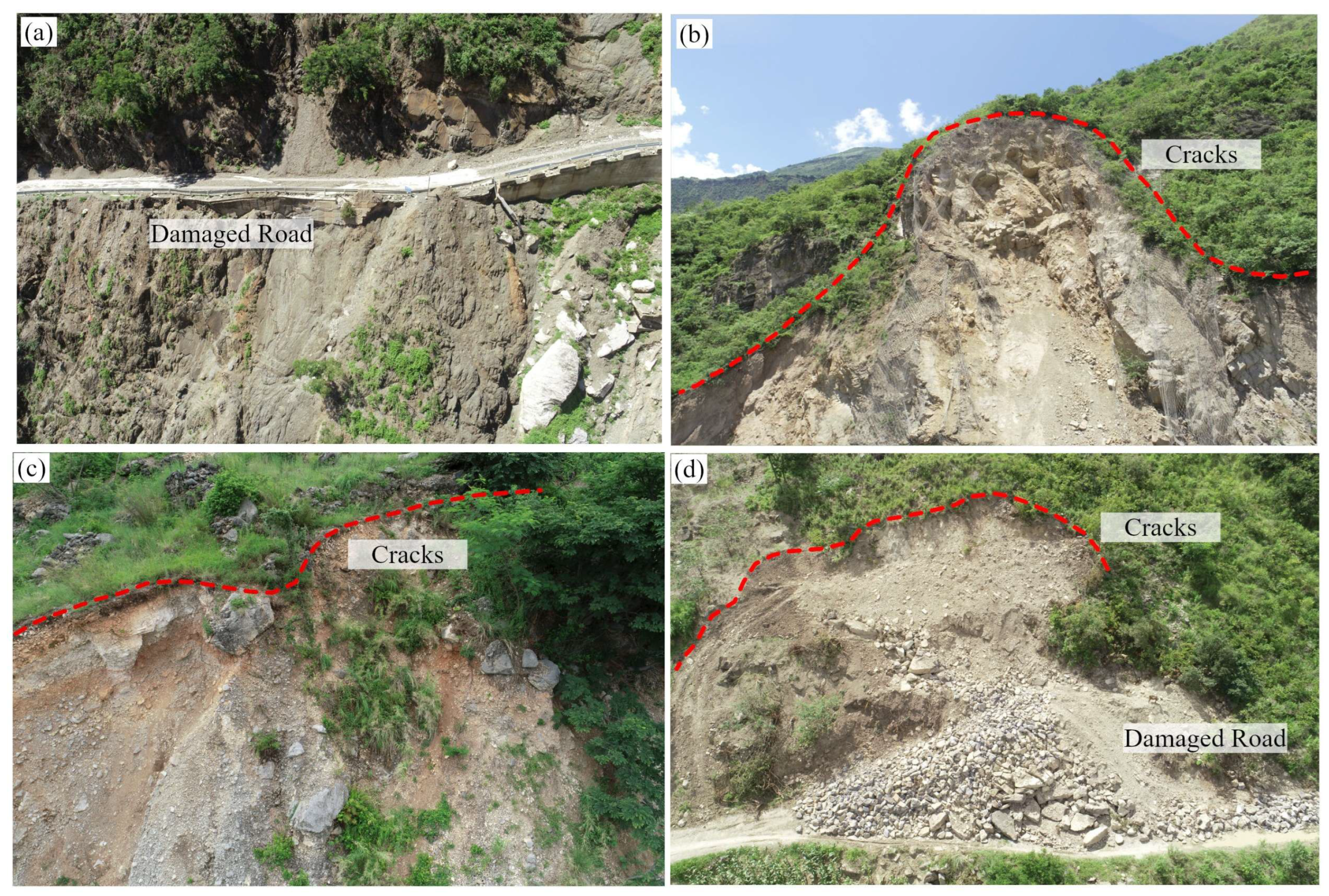
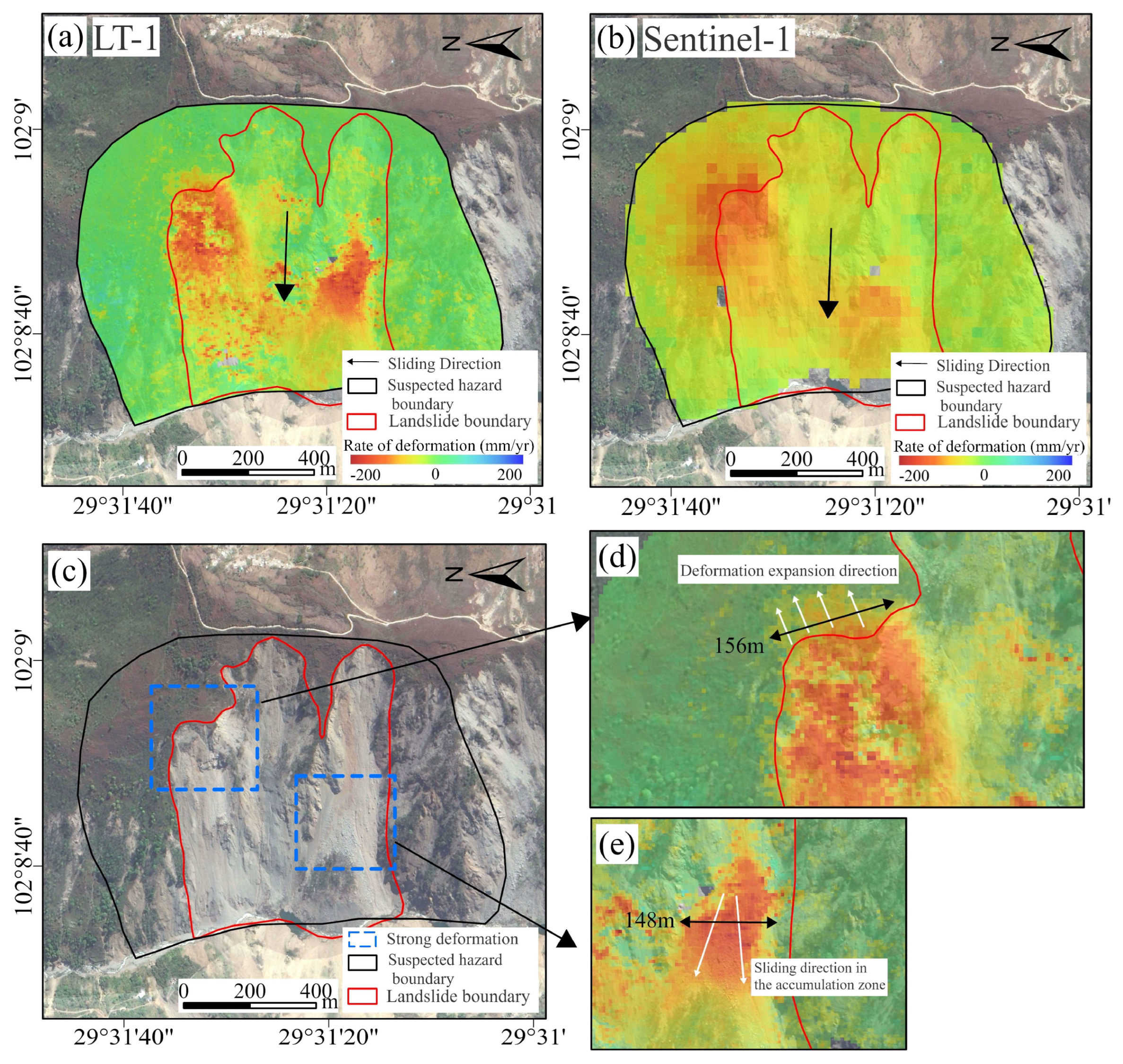
- By conducting Stacking-InSAR monitoring with LT-1 and Sentinel-1 in the Luding seismic zone, a total of 23 landslide hazards were identified, of which 22 were effectively detected by LT-1 and 18 by Sentinel-1. Optical imagery shows that these landslides exhibit distinct geomorphic boundaries and continuous deformation features, indicating that they remain in an unstable state.
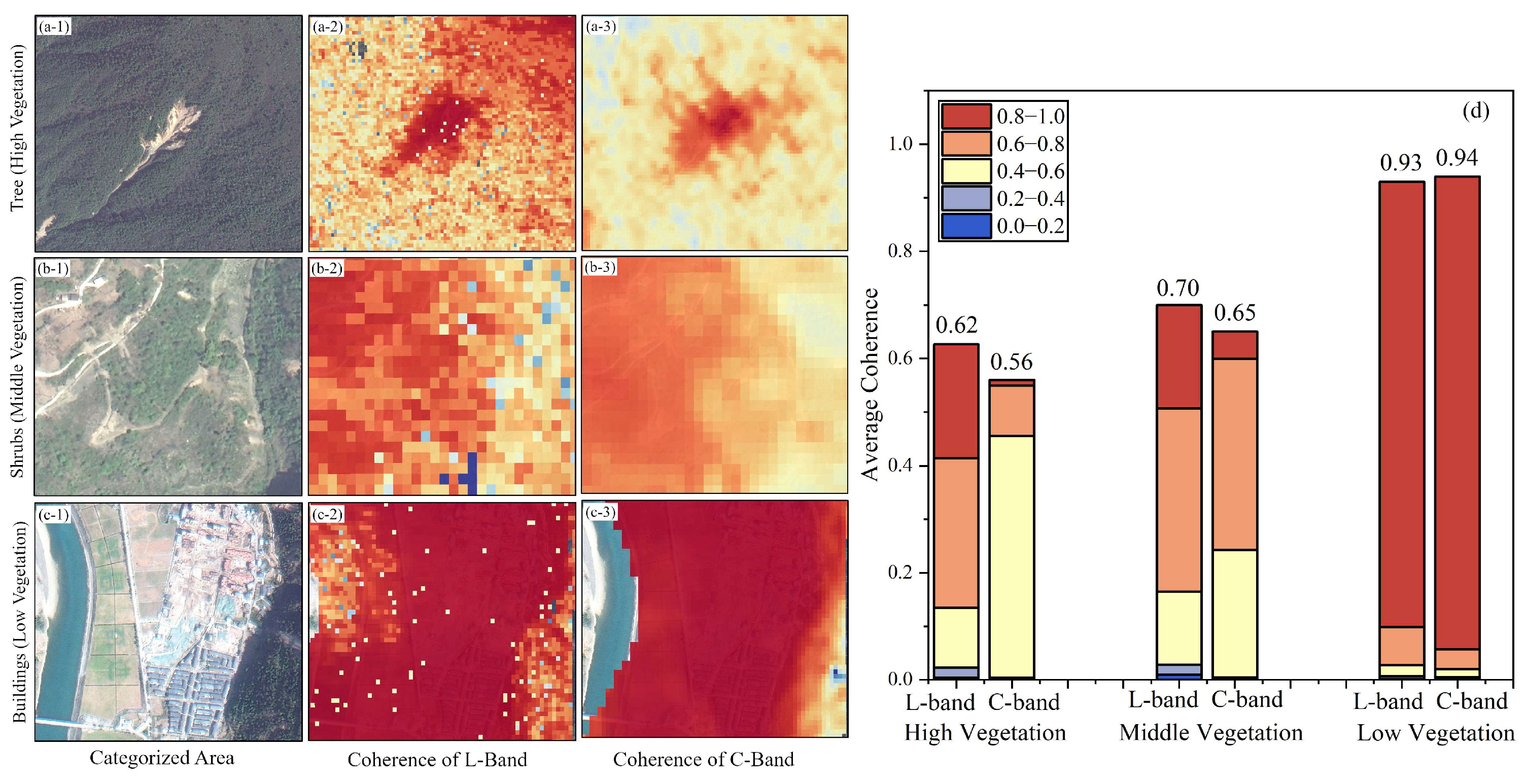
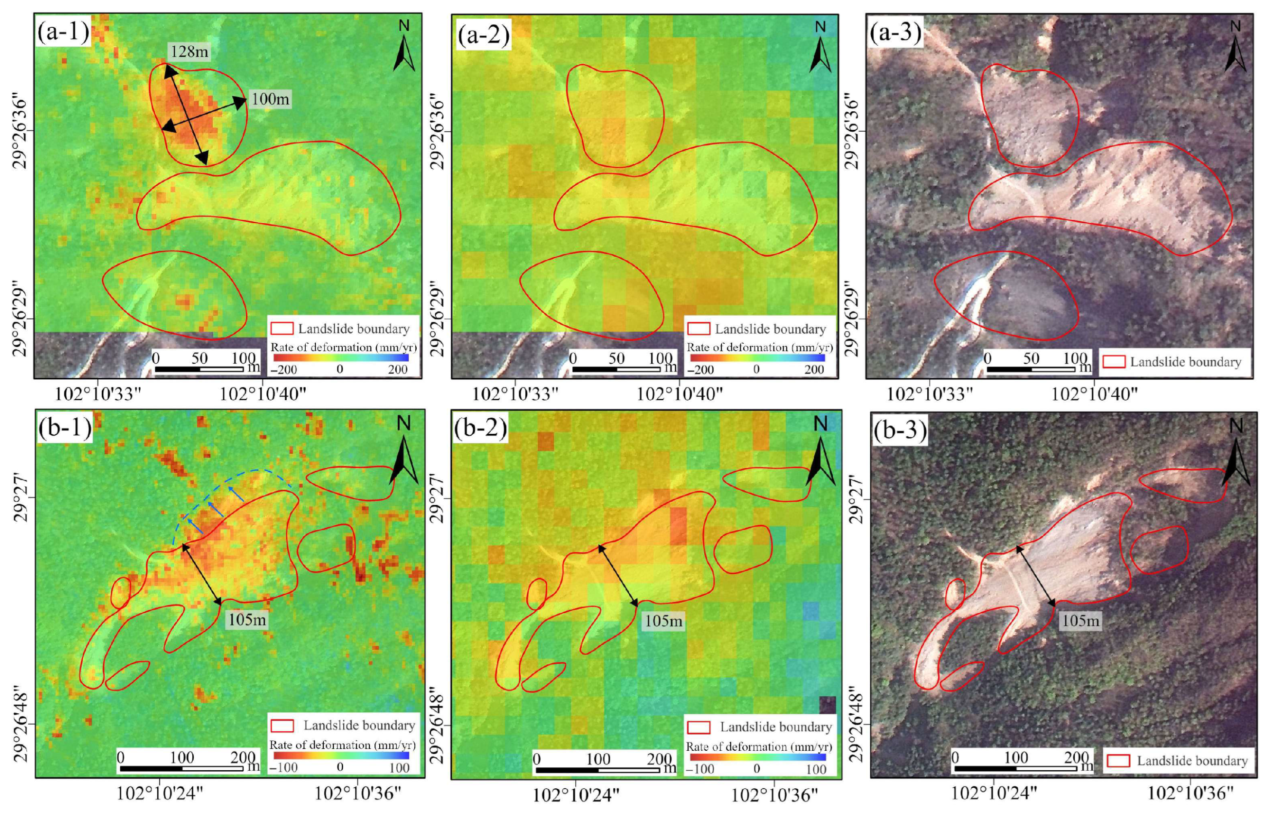
- In complex mountainous and densely vegetated environments, LT-1, with its long-wavelength penetration capability and high spatial resolution, can more accurately delineate the extent, boundaries, and spatial deformation characteristics of small-scale landslides. Moreover, integrating multi-source and multi-orbit satellite monitoring helps mitigate the impact of geometric distortions and enhances the completeness and accuracy of landslide detection.
- The study verifies the advantages of LT-1 in detecting small-scale landslides in complex mountainous and densely vegetated areas, providing new technical support for geological hazard monitoring and risk assessment.
- Future efforts to expand LT-1 archived data, optimize data processing methods, and integrate multi-source satellite monitoring can further enhance the completeness, accuracy, and stability of landslide identification, providing important reference for related research and applications.
Abstract
1. Introduction
2. Study Area and Datasets
2.1. Study Area
2.2. Datasets and Processing
3. Methodology
3.1. Stacking-InSAR Method
3.2. Accuracy Assessment of Deformation Results
3.3. Geometric Distortion Visibility Analysis
4. Results
4.1. Identification of Potential Landslides
- (1)
- Areas of significant surface deformation that do not have the topographic conditions for landslide development.
- (2)
- Areas of significant surface deformation due to human engineering activities.
- (3)
- Areas of significant deformation with landslide development (potential landslide areas).
4.2. Overall Identification Result
4.3. Validation and Analysis of Landslide Detection Results
5. Discussion
5.1. Analysis of Potential Landslide Detection in Densely Vegetated Areas
5.2. Analysis of Small-Scale Potential Landslide Detection
5.3. Limitations and Challenges of LT-1 in Landslide Detection
6. Conclusions
- (1)
- A total of 23 landslide hazards were identified by LT-1 and Sentinel-1, of which 22 were effectively identified by LT-1 and 18 by Sentinel-1. Strong signs of landslide movement and obvious landslide boundaries in the landslide areas can be seen in the optical satellite images, which indicate that these landslides continued to deform during the monitoring period and are still in an unstable state. These active landslides not only exhibit distinct geomorphic boundaries in the optical images but also show significant deformation during the monitoring period, indicating that they are in an unstable state.
- (2)
- In the analysis of landslide characteristics in complex mountainous environments and small-scale environments identified by LT-1, LT-1 performs better than short-wave bands in long-wave band identification and monitoring, especially in environments with vegetation. With its high spatial resolution advantage, LT-1 can more accurately detect the range and boundaries of deformation and more precisely outline the spatial deformation characteristics of landslides.
Author Contributions
Funding
Data Availability Statement
Acknowledgments
Conflicts of Interest
References
- Froude, M.J.; Petley, D.N. Global Fatal Landslide Occurrence from 2004 to 2016. Nat. Hazards Earth Syst. Sci. 2018, 18, 2161–2181. [Google Scholar] [CrossRef]
- Meng, W.; Xu, Y.; Cheng, W.-C.; Arulrajah, A. Landslide Event on 24 June in Sichuan Province, China: Preliminary Investigation and Analysis. Geosciences 2018, 8, 39. [Google Scholar] [CrossRef]
- Bostjančić, I.; Gulam, V.; Pollak, D.; Frangen, T. Comparative Analysis of Slope and Relief Energy for Small-Scale Landslide Susceptibility Mapping: Insights from Croatia. Remote Sens. 2025, 17, 2142. [Google Scholar] [CrossRef]
- Deđanski, V.; Durlević, U.; Kovjanić, A.; Lukić, T. GIS-Based Spatial Modeling of Landslide Susceptibility Using BWM-LSI: A Case Study—City of Smederevo (Serbia). Open Geosci. 2024, 16, 20220688. [Google Scholar] [CrossRef]
- Lv, J.; Zhang, R.; Shama, A.; Hong, R.; He, X.; Wu, R.; Bao, X.; Liu, G. Exploring the Spatial Patterns of Landslide Susceptibility Assessment Using Interpretable Shapley Method: Mechanisms of Landslide Formation in the Sichuan-Tibet Region. J. Environ. Manag. 2024, 366, 121921. [Google Scholar] [CrossRef]
- Suhail, H.A.; Yang, R.; Chen, H.; Rao, G. The Impact of River Capture on the Landscape Development of the Dadu River Drainage Basin, Eastern Tibetan Plateau. J. Asian Earth Sci. 2020, 198, 104377. [Google Scholar] [CrossRef]
- Huang, H.; Ju, S.; Duan, W.; Jiang, D.; Gao, Z.; Liu, H. Landslide Monitoring along the Dadu River in Sichuan Based on Sentinel-1 Multi-Temporal InSAR. Sensors 2023, 23, 3383. [Google Scholar] [CrossRef]
- Huang, R.; Li, W. Post-Earthquake Landsliding and Long-Term Impacts in the Wenchuan Earthquake Area, China. Eng. Geol. 2014, 182, 111–120. [Google Scholar] [CrossRef]
- Ouimet, W.B.; Whipple, K.X.; Granger, D.E. Beyond Threshold Hillslopes: Channel Adjustment to Base-Level Fall in Tectonically Active Mountain Ranges. Geology 2009, 37, 579–582. [Google Scholar] [CrossRef]
- Cook, K.L.; Hovius, N.; Wittmann, H.; Heimsath, A.M.; Lee, Y.-H. Causes of Rapid Uplift and Exceptional Topography of Gongga Shan on the Eastern Margin of the Tibetan Plateau. Earth Planet. Sci. Lett. 2018, 481, 328–337. [Google Scholar] [CrossRef]
- Clark, M.K.; House, M.A.; Royden, L.H.; Whipple, K.X.; Burchfiel, B.C.; Zhang, X.; Tang, W. Late Cenozoic Uplift of Southeastern Tibet. Geology 2005, 33, 525–528. [Google Scholar] [CrossRef]
- McColl, S.T.; Cook, S.J. A Universal Size Classification System for Landslides. Landslides 2024, 21, 111–120. [Google Scholar] [CrossRef]
- Hancox, G.T.; Perrin, N.D.; Dellow, G.D. Recent Studies of Historical Earthquake-Induced Landsliding, Ground Damage, and MM Intensity in New Zealand. Bull. N. Z. Soc. Earthq. Eng. 2002, 35, 59–95. [Google Scholar] [CrossRef]
- Hancox, G.T.; Perrin, N.D. Green Lake Landslide and Other Giant and Very Large Postglacial Landslides in Fiordland, New Zealand. Quat. Sci. Rev. 2009, 28, 1020–1036. [Google Scholar] [CrossRef]
- Zhang, R.; Lv, J.; Yang, Y.; Wang, T.; Liu, G. Analysis of the Impact of Terrain Factors and Data Fusion Methods on Uncertainty in Intelligent Landslide Detection. Landslides 2024, 21, 1849–1864. [Google Scholar] [CrossRef]
- Zhang, R.; Yang, Y.; Wang, T.; Liu, A.; Lv, J.; He, X.; Fu, Y.; Zhang, B.; Dai, K.; Liu, G. Co-Seismic Landslide Susceptibility Mapping for the Luding Earthquake Area Based on Heterogeneous Ensemble Machine Learning Models. Int. J. Digit. Earth 2024, 17, 2409337. [Google Scholar] [CrossRef]
- Liang, X.; Ge, Y.; Zeng, L.; Lyu, L.; Sun, Q.; Sun, Y.; Wang, X. Debris Flow Susceptibility Based on the Connectivity of Potential Material Sources in the Dadu River Basin. Eng. Geol. 2023, 312, 106947. [Google Scholar] [CrossRef]
- Bai, Y.; Wang, Y.; Ge, H.; Tie, Y. Slope Structures and Formation of Rock-Soil Aggregate Landslides in Deeply Incised Valleys. J. Mt. Sci. 2020, 17, 316–328. [Google Scholar] [CrossRef]
- Zhou, X.; Fan, S.; Sun, H.; Tang, L.; Ma, F. Practices of Environmental Protection, Technological Innovation, Economic Promotion and Social Equity in Hydropower Development: A Case Study of Cascade Hydropower Exploitation in China’s Dadu River Basin. Clean Technol. Environ. Policy 2021, 23, 2827–2841. [Google Scholar] [CrossRef]
- Bao, X.; Zhang, R.; Shama, A.; Li, S.; Xie, L.; Lv, J.; Fu, Y.; Wu, R.; Liu, G. Ground Deformation Pattern Analysis and Evolution Prediction of Shanghai Pudong International Airport Based on PSI Long Time Series Observations. Remote Sens. 2022, 14, 610. [Google Scholar] [CrossRef]
- Wang, T.; Zhang, R.; Zhan, R.; Shama, A.; Liao, M. Subsidence Monitoring and Mechanism Analysis of Anju Airport in Suining Based on InSAR and Numerical Simulation. Remote Sens. 2022, 14, 3759. [Google Scholar] [CrossRef]
- Zheng, L.; Zhu, L.; Wang, W.; Guo, L.; Chen, B. Land Subsidence Related to Coal Mining in China Revealed by L-Band InSAR Analysis. Int. J. Environ. Res. Public. Health 2020, 17, 1170. [Google Scholar] [CrossRef] [PubMed]
- Xiang, W.; Zhang, R.; Liu, G.; Wang, X.; Mao, W.; Zhang, B.; Fu, Y.; Wu, T. Saline-Soil Deformation Extraction Based on an Improved Time-Series InSAR Approach. ISPRS Int. J. Geo-Inf. 2021, 10, 112. [Google Scholar] [CrossRef]
- Jiang, H.; Zhang, R.; Zhang, B.; Chen, K.; Liu, A.; Wang, T.; Yu, B.; Deng, L. Liaohe Oilfield Reservoir Parameters Inversion Based on Composite Dislocation Model Utilizing Two-Dimensional Time-Series InSAR Observations. Remote Sens. 2024, 16, 3314. [Google Scholar] [CrossRef]
- Liu, A.; Zhang, R.; Yang, Y.; Wang, T.; Wang, T.; Shama, A.; Zhan, R. Oilfield Reservoir Parameter Inversion Based on 2D Ground Deformation Measurements Acquired by a Time-Series MSBAS-InSAR Method. Remote. Sens. 2023, 16, 154. [Google Scholar] [CrossRef]
- Intrieri, E.; Raspini, F.; Fumagalli, A.; Lu, P.; Del Conte, S.; Farina, P.; Allievi, J.; Ferretti, A.; Casagli, N. The Maoxian Landslide as Seen from Space: Detecting Precursors of Failure with Sentinel-1 Data. Landslides 2018, 15, 123–133. [Google Scholar] [CrossRef]
- Lv, J.; Zhang, R.; Bao, X.; Wu, R.; Hong, R.; He, X.; Liu, G. Time-Series InSAR Landslide Three-Dimensional Deformation Prediction Method Considering Meteorological Time-Delay Effects. Eng. Geol. 2025, 350, 107986. [Google Scholar] [CrossRef]
- Ferretti, A.; Prati, C.; Rocca, F. Permanent Scatterers in SAR Interferometry. IEEE Trans. Geosci. Remote Sens. 2001, 39, 8–20. [Google Scholar] [CrossRef]
- Berardino, P.; Fornaro, G.; Lanari, R.; Sansosti, E. A New Algorithm for Surface Deformation Monitoring Based on Small Baseline Differential SAR Interferograms. IEEE Trans. Geosci. Remote Sens. 2002, 40, 2375–2383. [Google Scholar] [CrossRef]
- Cigna, F.; Tapete, D. Sentinel-1 Big Data Processing with P-SBAS InSAR in the Geohazards Exploitation Platform: An Experiment on Coastal Land Subsidence and Landslides in Italy. Remote Sens. 2021, 13, 885. [Google Scholar] [CrossRef]
- Hooper, A.; Zebker, H.; Segall, P.; Kampes, B. A New Method for Measuring Deformation on Volcanoes and Other Natural Terrains Using InSAR Persistent Scatterers. Geophys. Res. Lett. 2004, 31, 1–5. [Google Scholar] [CrossRef]
- Zhang, L.; Dai, K.; Deng, J.; Ge, D.; Liang, R.; Li, W.; Xu, Q. Identifying Potential Landslides by Stacking-InSAR in Southwestern China and Its Performance Comparison with SBAS-InSAR. Remote Sens. 2021, 13, 3662. [Google Scholar] [CrossRef]
- Liang, J.; Dong, J.; Zhang, S.; Zhao, C.; Liu, B.; Yang, L.; Yan, S.; Ma, X. Discussion on InSAR Identification Effectivity of Potential Landslides and Factors That Influence the Effectivity. Remote. Sens. 2022, 14, 1952. [Google Scholar] [CrossRef]
- Li, Z.; Dai, K.; Deng, J.; Liu, C.; Shi, X.; Tang, G.; Yin, T. Identifying Potential Landslides in Steep Mountainous Areas Based on Improved Seasonal Interferometry Stacking-InSAR. Remote Sens. 2023, 15, 3278. [Google Scholar] [CrossRef]
- Li, T.; Tang, X.; Li, S.; Zhou, X.; Zhang, X.; Xu, Y. Classification of Basic Deformation Products of L-Band Differential Interferometric SAR Satellite. Acta Geod. Cartogr. Sin. 2023, 52, 769. [Google Scholar] [CrossRef]
- Lin, H.; Deng, Y.; Zhang, H.; Liang, D.; Fang, T.; Wang, R. Impacts of Ionospheric Effects on Spaceborne Single-Pass SAR Imaging and Interferometry of LuTan-1. In Proceedings of the 2021 IEEE International Geoscience and Remote Sensing Symposium IGARSS, Brussels, Belgium, 12–16 July 2021; pp. 2282–2285. [Google Scholar]
- Yang, F.; Shi, X.; Dai, K.; Zhang, W.; Yang, S.; Han, J.; Wen, N.; Deng, J.; Li, T.; Yao, Y.; et al. Utilizing LuTan-1 SAR Images to Monitor the Mining-Induced Subsidence and Comparative Analysis with Sentinel-1. Remote. Sens. 2024, 16, 4281. [Google Scholar] [CrossRef]
- Strozzi, T.; Farina, P.; Corsini, A.; Ambrosi, C.; Thüring, M.; Zilger, J.; Wiesmann, A.; Wegmüller, U.; Werner, C. Survey and Monitoring of Landslide Displacements by Means of L-Band Satellite SAR Interferometry. Landslides 2005, 2, 193–201. [Google Scholar] [CrossRef]
- Delgado, F.; Shreve, T.; Borgstrom, S.; León-Ibáñez, P.; Castillo, J.; Poland, M. A Global Assessment of SAOCOM-1 L-Band Stripmap Data for InSAR Characterization of Volcanic, Tectonic, Cryospheric, and Anthropogenic Deformation. IEEE Trans. Geosci. Remote Sens. 2024, 62, 5216821. [Google Scholar] [CrossRef]
- Ji, Y.; Zhang, X.; Li, T.; Fan, H.; Xu, Y.; Li, P.; Tian, Z. Mining Deformation Monitoring Based on Lutan-1 Monostatic and Bistatic Data. Remote Sens. 2023, 15, 5668. [Google Scholar] [CrossRef]
- Li, H.; Li, B.; Li, Y.; Duan, H. The Stability Analysis of Mt. Gongga Glaciers Affected by the 2022 Luding MS 6.8 Earthquake Based on LuTan-1 and Sentinel-1 Data. Remote Sens. 2023, 15, 3882. [Google Scholar] [CrossRef]
- Xiong, J.; Chen, T.; Yang, G.; Wang, R.; Li, M.; Zhao, L.; Chen, C. Discussion on the Effectiveness of Landslide Hazard Identification and Factors Affecting the Effectiveness of LT-1 Satellite Based on InSAR Technology. Geocarto Int. 2025, 40, 2461539. [Google Scholar] [CrossRef]
- Xu, G.; Kamp, P.J.J. Tectonics and Denudation Adjacent to the Xianshuihe Fault, Eastern Tibetan Plateau: Constraints from Fission Track Thermochronology. J. Geophys. Res. Solid Earth 2000, 105, 19231–19251. [Google Scholar] [CrossRef]
- Li, C.; Wang, X.; He, C.; Wu, X.; Kong, Z.; Li, X. China National Digital Geological Map (Public Version at 1:200000 Scale) Spatial Database. Geol. China 2019, 46 (Suppl. S1), 1–10. [Google Scholar]
- Bai, M.; Chevalier, M.-L.; Leloup, P.H.; Li, H.; Pan, J.; Replumaz, A.; Wang, S.; Li, K.; Wu, Q.; Liu, F.; et al. Spatial Slip Rate Distribution Along the SE Xianshuihe Fault, Eastern Tibet, and Earthquake Hazard Assessment. Tectonics 2021, 40, e2021TC006985. [Google Scholar] [CrossRef]
- Bufe, A.; Cook, K.L.; Galy, A.; Wittmann, H.; Hovius, N. The Effect of Lithology on the Relationship between Denudation Rate and Chemical Weathering Pathways—Evidence from the Eastern Tibetan Plateau. Earth Surf. Dyn. 2022, 10, 513–530. [Google Scholar] [CrossRef]
- Li, Z.W.; Ding, X.L.; Huang, C.; Wadge, G.; Zheng, D.W. Modeling of Atmospheric Effects on InSAR Measurements by Incorporating Terrain Elevation Information. J. Atmospheric Sol.-Terr. Phys. 2006, 68, 1189–1194. [Google Scholar] [CrossRef]
- Sandwell, D.T.; Price, E.J. Phase Gradient Approach to Stacking Interferograms. J. Geophys. Res. Solid Earth 1998, 103, 30183–30204. [Google Scholar] [CrossRef]
- Colesanti, C.; Wasowski, J. Investigating Landslides with Space-Borne Synthetic Aperture Radar (SAR) Interferometry. Eng. Geol. 2006, 88, 173–199. [Google Scholar] [CrossRef]
- Novellino, A.; Cigna, F.; Brahmi, M.; Sowter, A.; Bateson, L.; Marsh, S. Assessing the Feasibility of a National InSAR Ground Deformation Map of Great Britain with Sentinel-1. Geosciences 2017, 7, 19. [Google Scholar] [CrossRef]
- Ren, T.; Gong, W.; Bowa, V.M.; Tang, H.; Chen, J.; Zhao, F. An Improved R-Index Model for Terrain Visibility Analysis for Landslide Monitoring with InSAR. Remote Sens. 2021, 13, 1938. [Google Scholar] [CrossRef]
- Dai, K.; Tie, Y.; Xu, Q. Early Identification of Potential Landslide Geohazards in Alpine-Canyon Terrain Based on SAR Interferometry—A Case Study of the Middle Section of Yalong River. J. Radars 2020, 9, 554–568. [Google Scholar] [CrossRef]
- Notti, D.; Herrera, G.; Bianchini, S.; Meisina, C.; García-Davalillo, J.C.; Zucca, F. A methodology for improving landslide PSI data analysis. Int. J. Remote Sens. 2014, 35, 2186–2214. [Google Scholar] [CrossRef]
- Chen, H.; Qin, Z.; Liu, B.; Peng, R.; Yu, Z.; Yao, T.; Yang, Z.; Feng, G.; Wang, W. Assessing the Landslide Identification Capability of LuTan-1 in Hilly Regions: A Case Study in Longshan County, Hunan Province. Remote Sens. 2025, 17, 960. [Google Scholar] [CrossRef]
- Dai, F.C.; Lee, C.F.; Ngai, Y.Y. Landslide Risk Assessment and Management: An Overview. Eng. Geol. 2002, 64, 65–87. [Google Scholar] [CrossRef]
- Iverson, R.M. Landslide Triggering by Rain Infiltration. Water Resour. Res. 2000, 36, 1897–1910. [Google Scholar] [CrossRef]

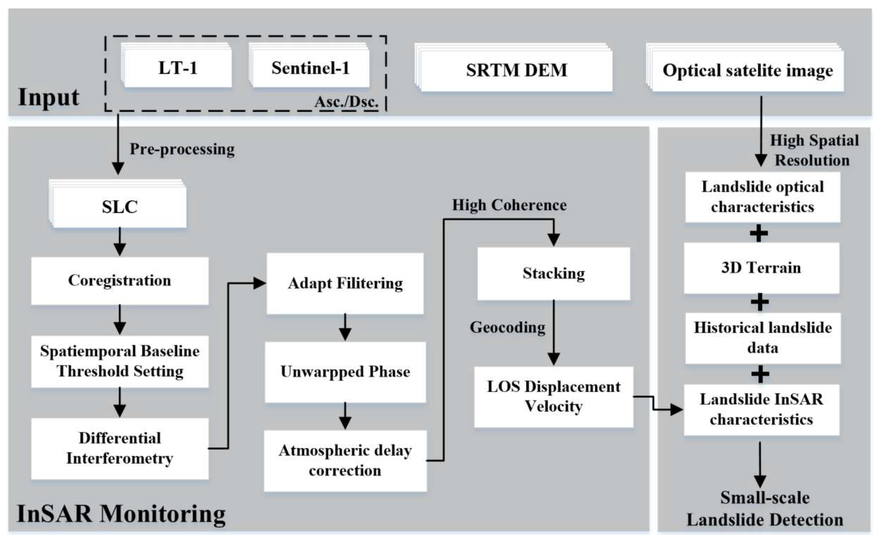


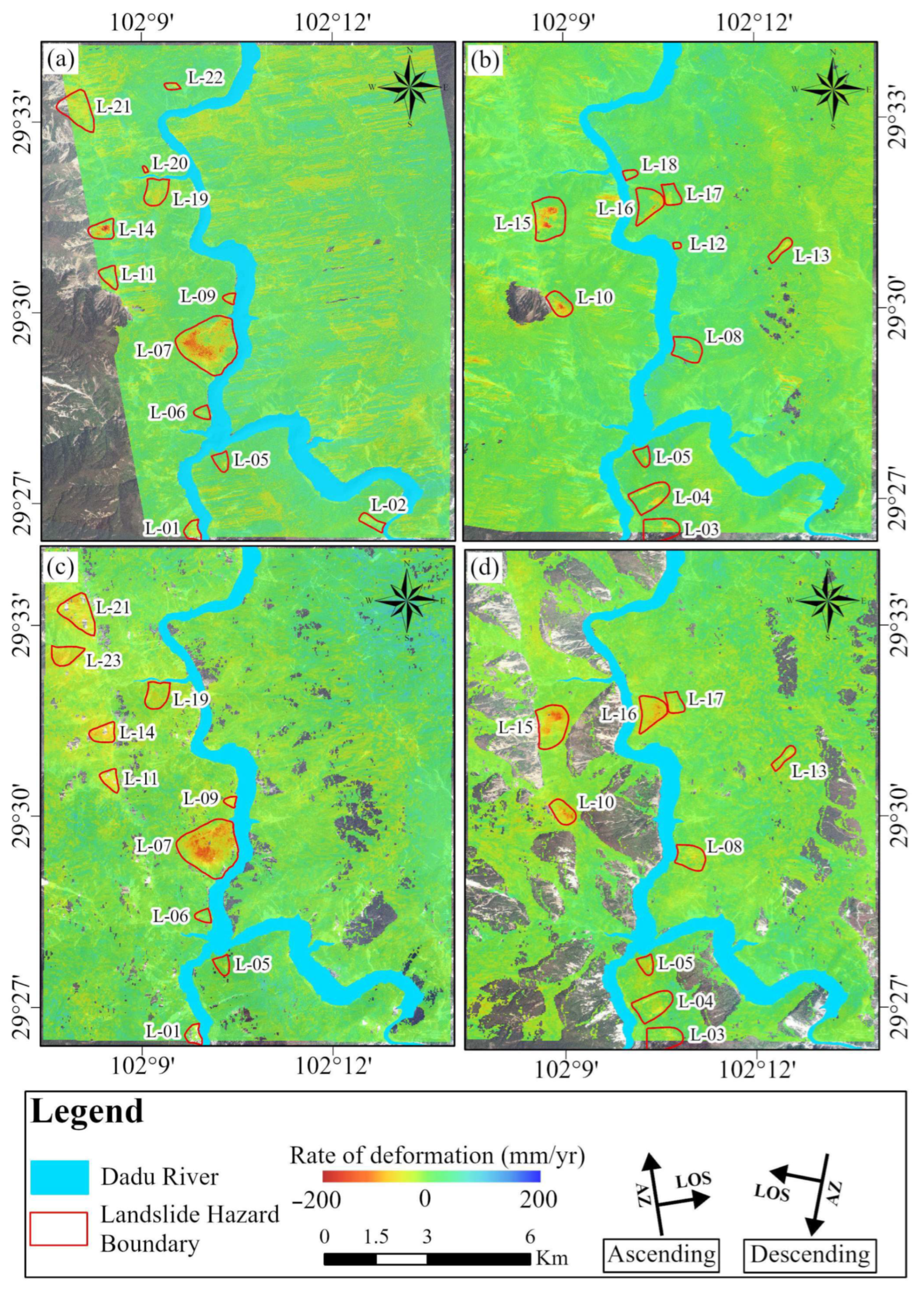
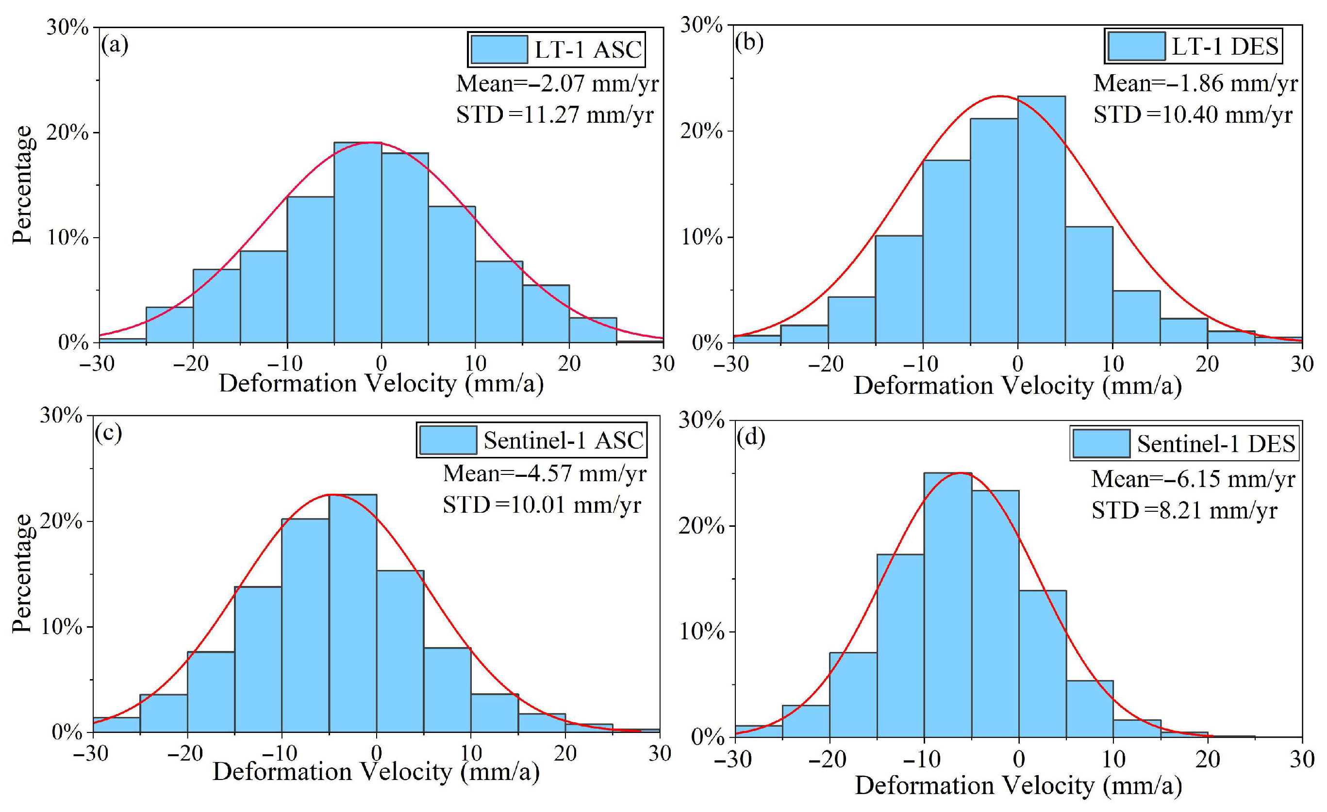

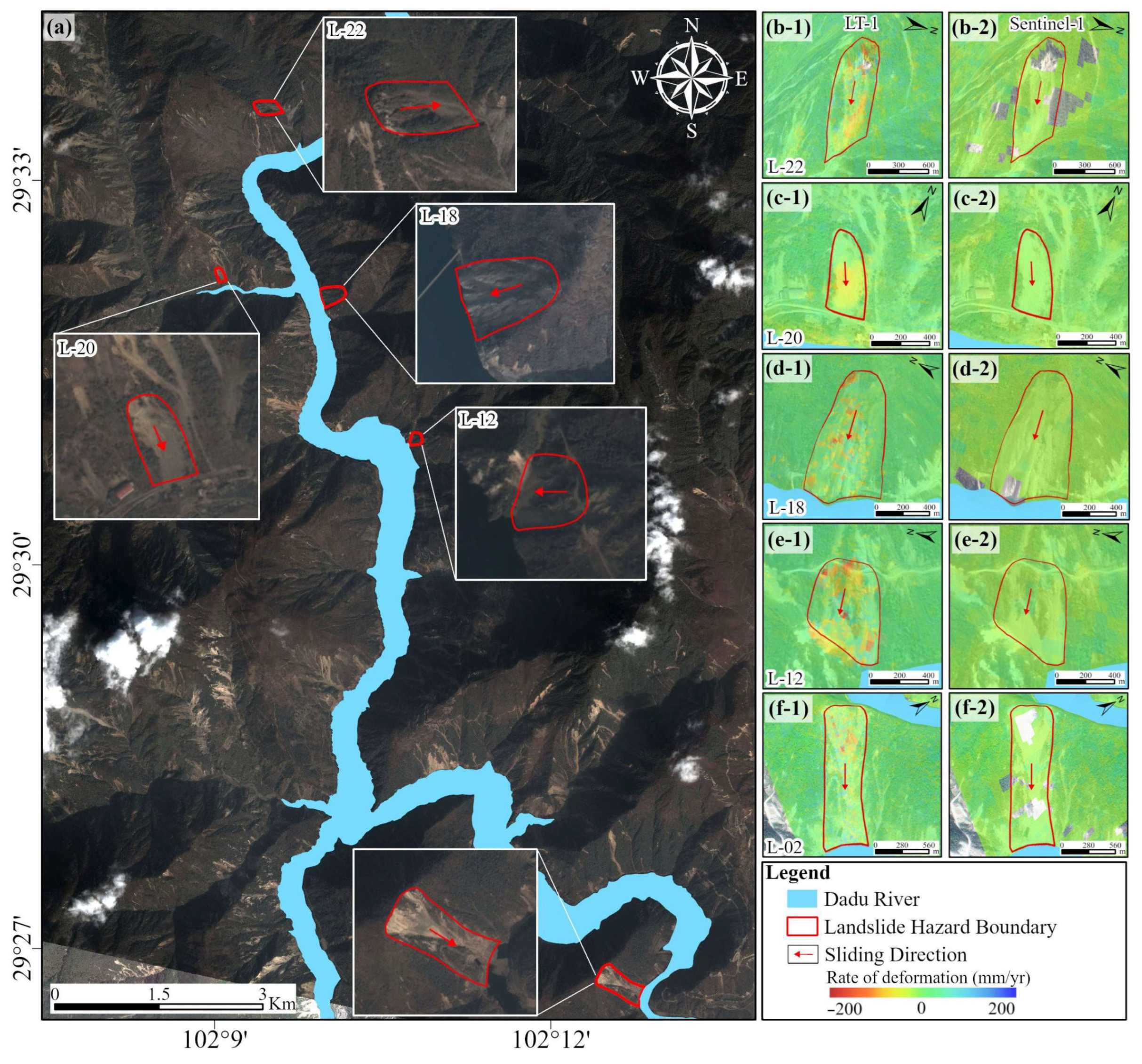


| Parameter | LT-1 | Sentinel-1 | ||
|---|---|---|---|---|
| Orbit direction | Ascending | Descending | Ascending | Descending |
| Band/Wavelength (cm) | L(23.6) | C(5.6) | ||
| Pixel spacing (Azimuth/range m) | 1.7/1.9 | 2.3/13.9 | ||
| Image Mode | STRIP1 | IW | ||
| Image Width (km) | 50 | 250 | ||
| Polarization | HH | VV | ||
| Acquisition time | August 2023–April 2024 | September 2023–April 2024 | January 2023–April 2024 | February 2023–April 2024 |
| Number of data | 9 | 7 | 27 | 31 |
| Landslides | Orbit | Satellite Platform | Longitude (°) | Latitude (°) | Area (km2) | Max Velocity (mm/yr) | Aspect | Elevation (m) |
|---|---|---|---|---|---|---|---|---|
| L-01 | Ascending | LT-1 & S1 | 102°09′40″ | 29°26′31″ | 0.177 | −91 & −71 | E | 1129–1469 |
| L-02 | Ascending | LT-1 | 102°12′25″ | 29°26′46″ | 0.172 | −85 | SE | 961–1576 |
| L-03 | Descending | LT-1 & S1 | 102°10′52″ | 29°26′31″ | 0.525 | −117 & −55 | W | 1239–1725 |
| L-04 | Descending | LT-1 & S1 | 102°10′37″ | 29°27′11″ | 0.584 | −83 & −71 | W | 1247–1769 |
| L-05 | Ascending & Descending | LT-1 & S1 | 102°10′19″ | 29°27′29″ | 0.165 | −90 & −85 | N | 1186–1645 |
| L-06 | Ascending | LT-1 & S1 | 102°09′47″ | 29°28′23″ | 0.117 | −69 & −46 | E | 1153–1447 |
| L-07 | Ascending | LT-1 & S1 | 102°09′29″ | 29°29′31″ | 1.845 | −183 & −148 | E | 1144–2113 |
| L-08 | Descending | LT-1 & S1 | 102°11′10″ | 29°29′17″ | 0.441 | −102 & −83 | W | 1169–1699 |
| L-09 | Ascending | LT-1 & S1 | 102°10′16″ | 29°30′11″ | 0.071 | −80 & −75 | E | 1121–1345 |
| L-10 | Descending | LT-1 & S1 | 102°09′04″ | 29°29′53″ | 0.319 | −160 & −131 | NW | 1743–2133 |
| L-11 | Ascending | LT-1 & S1 | 102°08′17″ | 29°30′40″ | 0.204 | −93 & −86 | E | 1518–1877 |
| L-12 | Descending | LT-1 | 102°10′52″ | 29°30′58″ | 0.031 | −65 | W | 1148–1306 |
| L-13 | Descending | LT-1 & S1 | 102°12′32″ | 29°31′01″ | 0.174 | −86 & −72 | SW | 2063–2643 |
| L-14 | Ascending | LT-1 & S1 | 102°08′06″ | 29°31′16″ | 0.283 | −196 & −102 | E | 1391–1811 |
| L-15 | Descending | LT-1 & S1 | 102°09′04″ | 29°31′30″ | 0.810 | −191 & −134 | W | 1371–1888 |
| L-16 | Descending | LT-1 & S1 | 102°07′05″ | 29°37′05″ | 0.495 | −138 & −114 | W | 1231–1698 |
| L-17 | Descending | LT-1 & S1 | 102°10′44″ | 29°31′37″ | 0.144 | −105 & −90 | N | 1370–1777 |
| L-18 | Descending | LT-1 | 102°10′08″ | 29°32′06″ | 0.079 | −69 | W | 1140–1467 |
| L-19 | Ascending | LT-1 & S1 | 102°09′11″ | 29°31′41″ | 0.389 | −88 & −71 | N | 1183–1756 |
| L-20 | Ascending | LT-1 | 102°09′04″ | 29°32′17″ | 0.017 | −66 | N | 1204–1378 |
| L-21 | Ascending | LT-1 & S1 | 102°07′37″ | 29°33′11″ | 0.674 | −111 & −101 | E | 1608–2242 |
| L-22 | Ascending | LT-1 | 102°09′22″ | 29°33′32″ | 0.063 | −101 | SE | 1388–1696 |
| L-23 | Ascending | S1 | 102°07′41″ | 29°32′20″ | 0.339 | −87 | N | 1492–2054 |
| SAR Satellite | Orbit Direction | Azimuth Angle | Heading Angle | Incidence Angle |
|---|---|---|---|---|
| LT-1 | Ascending | 79.43° | 349.28° | 30.38° |
| Descending | 289.93° | 189.93° | 41.86° | |
| Sentinel-1 | Ascending | 77.43° | 347.43° | 39.27° |
| Descending | 282.65° | 192.65° | 33.89° |
| Landslides | Landslide Hazard Area | Historical Landslide Area | Overlap Rate | Landslides | Landslide Hazard Area | Historical Landslide Area | Overlap Rate |
|---|---|---|---|---|---|---|---|
| L-01 | 0.18 km2 | 0.13 km2 | 73.0% | L-13 | 0.17 km2 | 0.05 km2 | 26.9% |
| L-02 | 0.17 km2 | 0.15 km2 | 87.1% | L-14 | 0.28 km2 | 0.18 km2 | 63.8% |
| L-03 | 0.53 km2 | 0.07 km2 | 13.3% | L-15 | 0.86 km2 | 0.58 km2 | 67.4% |
| L-04 | 0.58 km2 | 0.11 km2 | 18.0% | L-16 | 0.50 km2 | 0.05 km2 | 9.2% |
| L-05 | 0.16 km2 | 0.02 km2 | 12.1% | L-17 | 0.22 km2 | 0.05 km2 | 22.7% |
| L-06 | 0.12 km2 | 0.07 km2 | 57.1% | L-18 | 0.08 km2 | 0.07 km2 | 87.3% |
| L-07 | 1.85 km2 | 0.53 km2 | 28.8% | L-19 | 0.39 km2 | 0.11 km2 | 28.7% |
| L-08 | 0.44 km2 | 0.10 km2 | 22.4% | L-20 | 0.02 km2 | 0.01 km2 | 80.3% |
| L-09 | 0.07 km2 | 0.06 km2 | 89.1% | L-21 | 0.67 km2 | 0.35 km2 | 52.5% |
| L-10 | 0.32 km2 | 0.21 km2 | 64.7% | L-22 | 0.06 km2 | 0.04 km2 | 62.5% |
| L-11 | 0.20 km2 | 0.17 km2 | 83.3% | L-23 | 0.34 km2 | 0.13 km2 | 38.8% |
| L-12 | 0.03 km2 | 0.02 km2 | 51.2% |
Disclaimer/Publisher’s Note: The statements, opinions and data contained in all publications are solely those of the individual author(s) and contributor(s) and not of MDPI and/or the editor(s). MDPI and/or the editor(s) disclaim responsibility for any injury to people or property resulting from any ideas, methods, instructions or products referred to in the content. |
© 2025 by the authors. Licensee MDPI, Basel, Switzerland. This article is an open access article distributed under the terms and conditions of the Creative Commons Attribution (CC BY) license (https://creativecommons.org/licenses/by/4.0/).
Share and Cite
Jiang, H.; Yang, X.; Wen, H.; Wang, X.; Lei, C.; Zhang, R. Detection of Small-Scale Potential Landslides in Vegetation-Covered Areas of the Hengduan Mountains Using LT-1 Imagery: A Case Study of the Luding Seismic Zone. Remote Sens. 2025, 17, 3225. https://doi.org/10.3390/rs17183225
Jiang H, Yang X, Wen H, Wang X, Lei C, Zhang R. Detection of Small-Scale Potential Landslides in Vegetation-Covered Areas of the Hengduan Mountains Using LT-1 Imagery: A Case Study of the Luding Seismic Zone. Remote Sensing. 2025; 17(18):3225. https://doi.org/10.3390/rs17183225
Chicago/Turabian StyleJiang, Hang, Xianhua Yang, Hui Wen, Xiaogang Wang, Chuanyang Lei, and Rui Zhang. 2025. "Detection of Small-Scale Potential Landslides in Vegetation-Covered Areas of the Hengduan Mountains Using LT-1 Imagery: A Case Study of the Luding Seismic Zone" Remote Sensing 17, no. 18: 3225. https://doi.org/10.3390/rs17183225
APA StyleJiang, H., Yang, X., Wen, H., Wang, X., Lei, C., & Zhang, R. (2025). Detection of Small-Scale Potential Landslides in Vegetation-Covered Areas of the Hengduan Mountains Using LT-1 Imagery: A Case Study of the Luding Seismic Zone. Remote Sensing, 17(18), 3225. https://doi.org/10.3390/rs17183225


