Abstract
Atmospheric pollution constitutes one of the key environmental challenges hindering Atmospheric pollution is a key environmental challenge constraining the sustainable development of Gansu Province’s land-based Belt and Road corridor and its regional ecological barrier function. The spatiotemporal heterogeneity of aerosol optical depth (AOD) profoundly impacts regional environmental quality. Based on MODIS AOD, NCEP reanalysis, and emission data, this study employed trend analysis (Mann–Kendall test) and attribution analysis (multiple linear regression combined with LMG and Spearman correlation) to investigate the spatiotemporal evolution of AOD over Gansu Province during 2009–2019 and its meteorological and emission drivers. Key findings include the following: (1) AOD exhibited significant spatial heterogeneity, with high values concentrated in the Hexi Corridor and central regions; monthly variation showed a unimodal pattern (peak value of 0.293 in April); and AOD generally declined slowly province-wide during 2009–2019 (52.8% of the area showed significant decreases). (2) Following the implementation of the Air Pollution Prevention and Control Action Plan in 2013 (2014–2019), AOD trends stabilized or declined in 99.8% of the area, indicating significant improvement. (3) Meteorological influences displayed distinct regional-seasonal specificity—the Hexi Corridor (arid zone) was characterized by strong negative correlations with relative humidity (RH2) and wind speed (WS) year-round, and positive correlations with temperature (T2) in spring but negative in summer in the north; the Hedong region (industrial zone) featured strong positive correlations with planetary boundary layer height (PBLH) in summer (r > 0.6) and with T2 in spring/summer; and the Gannan Plateau (alpine zone) showed positive WS correlations in spring and weak positive RH2 correlations in spring/autumn, highlighting the decisive regulatory role of underlying surface properties. (4) Emission factors (PM2.5, , , , OM, and BC) dominated (>50% relative contribution) in 80% of seasonal scenarios, prevailing in most regions (Hexi: 71–95% year-round; Hedong: 68–80% year-round; and Gannan: 69–72% in spring/summer). Key components included BC (contributing > 30% in 11 seasons, e.g., 52.5% in Hedong summer), + (>57% in Hexi summer/autumn), and OM (20.3% in Gannan summer, 19.0% province-wide spring). Meteorological factors were the primary driver exclusively in Gannan winter (82%, T2-dominated) and province-wide summer (67%, RH2 + WS-dominated). In conclusion, Gansu’s AOD evolution is co-driven by emission factors (dominant province-wide) and meteorological factors (regionally and seasonally specific). Post-2013 environmental policies effectively promoted regional air quality improvement, providing a scientific basis for differentiated aerosol pollution control in arid, industrial, and alpine zones.
1. Introduction
Atmospheric aerosol optical depth (AOD), a key parameter characterizing atmospheric aerosol loading, serves as a crucial metric for studying its radiative climatic effects [1,2,3] and assessing atmospheric environmental pollution [4,5,6]. Aerosols influence the Earth–atmosphere system balance through direct and indirect radiative effects, significantly impacting greenhouse gas concentrations, the water cycle, and environmental health [7,8,9,10]. Satellite remote sensing (e.g., MODIS), leveraging its large-scale coverage advantage, has become an effective means for regional AOD monitoring [11]. Its data have demonstrated strong applicability in spatiotemporal studies across multiple global regions, including Yunnan–Guizhou–Sichuan, East Asia, and India [12,13,14,15,16].
Gansu Province, situated as a core land corridor of the “Belt and Road Initiative” and an arid-semi-arid ecological transition zone, features complex topography. It acts as a critical hub for the eastward transport of Eurasian dust and the cross-border transport of regional pollutants. The spatiotemporal evolution of AOD in this region is not only vital for local, precise air pollution prevention and control but also provides strategic evidence for clarifying the aerosol transboundary transport mechanisms along the Silk Road Economic Belt and evaluating the impact of dust on air quality in urban clusters along the route. However, the existing ground-based observation network (e.g., CARSNET) suffers from extreme sparsity of stations (only four stations province-wide: Dunhuang, Jiuquan, Minqin, and Lanzhou), resulting in severely inadequate spatial representativeness [17,18]. This limitation impedes comprehensive province-scale research. Although progress has been made in aerosol source apportionment within the arid Northwest region [19], a systematic understanding of the long-term spatiotemporal heterogeneity patterns of AOD in this strategic corridor of Gansu and their response mechanisms to meteorological factors remains lacking. This knowledge gap constrains regional atmospheric collaborative governance and the optimization of ecological security barrier functions.
Therefore, this study integrates MODIS MOD04_L2 AOD products (Raytheon Space Systems, Santa Barbara, CA, USA) and NCEP reanalysis data from 2009 to 2019. It aims to reveal the spatial patterns and temporal trends of AOD across Gansu Province at monthly, seasonal, and annual scales, and to quantitatively analyze the influence mechanisms of meteorological and emission factors on its spatial distribution. This approach seeks to elucidate the long-term, large-scale variation patterns. The research outcomes are expected to provide scientific support for predicting dust transport pathways along the Belt and Road, implementing cross-border pollution joint prevention and control, and conducting ecological protection and restoration in arid regions.
2. Study Area, Data, and Methodology
2.1. Study Area
The topography of Gansu Province is shown in Figure 1. Located in the inland northwest of China, Gansu Province spans approximately 32°11′–42°57′N and 92°13′–108°46′E, stretching over 1600 km from east to west. The region features a long, narrow, and complex topography, including mountains, plateaus, plains, valleys, deserts, and the Gobi. The terrain slopes from southwest to northeast, situated at the convergence of the Tibetan Plateau, the Loess Plateau, and the Inner Mongolian Plateau. Most areas have elevations between 1500 m and 3000 m, characterized as a mountainous plateau. This complex topography results in diverse climate types, encompassing subtropical monsoon, temperate monsoon, temperate continental (arid), and plateau alpine climates. However, most areas within the province are dry, with arid and semi-arid regions accounting for 75% of the total area.
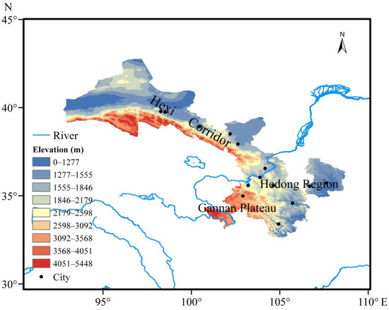
Figure 1.
Overview map of the study area.
2.2. Data Sources and Preprocessing
MODIS aerosol data (instrument manufactured by Raytheon Space Systems, Santa Barbara, CA, USA; data processed by NASA Goddard Space Flight Center, Greenbelt, MD, USA), NASA’s Level 2 aerosol optical depth product, is widely used in atmospheric sciences to retrieve atmospheric aerosol optical properties over global oceans and land. The product used in this study is MOD04_L2 from Collection 6 (C6), with a spatial resolution of 10 km. In our previous work [20], using ground-based sun photometer AOD observations, we systematically evaluated the accuracy of MODIS Collection 6 (C6) Deep Blue (DB) algorithm and DB-Dark Target (DT) merged algorithm AOD products over Gansu Province. The validation covered overall regional accuracy, accuracy over different underlying surface types (including valley cities, deserts/Gobi, and ecologically fragile areas), and seasonal accuracy (Figure 2). Validation results indicated that for overall regional accuracy, the DB algorithm dataset (correlation coefficient R = 0.920 with ground observations, RMSE = 0.182) generally outperformed the DB-DT-Merge algorithm dataset. For underlying surface validation, the DB algorithm demonstrated high accuracy in Lanzhou (valley city surface, R = 0.929, RMSE = 0.179), Dunhuang (desert/Gobi surface, R = 0.929, RMSE = 0.171), and Minqin (ecologically fragile area, R = 0.933, RMSE = 0.182). Seasonal validation revealed that both algorithms exhibited relatively lower retrieval accuracy in summer (R range: 0.683–0.868; RMSE range: 0.195–0.277), while the DB algorithm showed higher accuracy in spring (R = 0.938; RMSE = 0.161), autumn (R = 0.896, RMSE = 0.170), and winter (R = 0.917; RMSE = 0.186). The DB-DT-Merge algorithm outperformed the DB algorithm only in winter (R = 0.945, RMSE = 0.153; DB: R = 0.917, RMSE = 0.186). Based on these comprehensive accuracy assessment results, this study selected the MODIS DB algorithm AOD dataset for subsequent analysis.
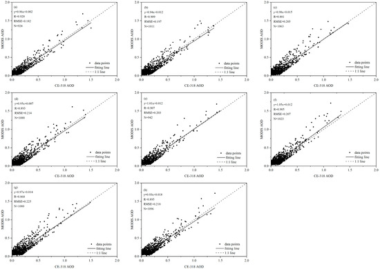
Figure 2.
Comparison of the accuracy of MODIS AOD products and ground-based observation data: (a). DB-30 km
30 km, (b). DB-50 km 50 km, (c). DB-70 km 70 km, (d). DB-90 km 90 km, (e). DB-DT-Combined-30 km 30 km, (f). DB-DT-Combined-50 km 50 km, (g). DB-DT-Combined-70 km 70 km, (h). DB-DT-Combined-90 km 90 km (cited from the paper by Huang et al. [20]).
MODIS data preprocessing involved (1) using the HDF-EOS To GeoTIFF Conversion Tool (HEG) to batch process raw MODIS data for mosaicking and coordinate reprojection, generating TIFF files in a standard geographic projection; (2) calculating daily mean values based on ArcGIS. Through time series analysis of daily data, monthly mean, seasonal mean, and annual mean AOD datasets were further computed; (3) visualizing spatial distributions across multiple temporal scales using ArcMap software (version 10.2). To enhance spatial matching accuracy, AOD data were resampled to a 0.1° × 0.1° spatial resolution using the bilinear interpolation method.
Meteorological data were sourced from the NCEP (National Centers for Environmental Prediction; College Park, MD, USA) FNL (Final) Operational Global Analysis data, produced and archived by NOAA/NCEP and NOAA/NCEI (Asheville, NC, USA). The selected parameters included 2 m air temperature (T2), 2 m relative humidity (RH2), planetary boundary layer height (PBLH), and 10 m wind speed (WS, calculated from U and V wind components). The original dataset has a spatial resolution of 0.25° and a temporal resolution of 6 h. To ensure spatiotemporal consistency with the AOD data, the spatial resolution of the meteorological variables was first uniformly adjusted to 0.1° using bilinear interpolation. Subsequently, daily and monthly mean values matching the AOD data temporal scale were calculated.
Emission data were sourced from Tracking Air Pollution in China (TAP). The selected parameters include PM2.5 and its components (, , , OM, and BC). The spatial resolution is 10 km, and the temporal resolution is daily. Processing methods were similar to those used for meteorological data.
A three-stage quality control procedure was applied to all data: (1) Range check: Outliers were removed based on physical characteristic thresholds for each parameter. (2) Missing value processing: Gaps were filled using nearest-neighbor pixel interpolation or marked as invalid. (3) Spatiotemporal consistency check: A sliding window method was used to detect abrupt anomalies in both spatial and temporal dimensions. After this quality control, a standardized analysis dataset with complete spatiotemporal information was formed, providing a reliable data foundation for subsequent research.
2.3. Methodology
Considering seasonal variation characteristics, analyses were conducted separately for spring (March–May), summer (June–August), autumn (September–November), and winter (December–February). The time span covered the entire study period (2009–2019) and two sub-periods (2009–2013 and 2014–2019). Spatial analysis was confined within the administrative boundaries of Gansu Province (90–110°E, 30–45°N).
This study employed the Mann–Kendall (MK) non-parametric test to analyze the statistical significance of trends in AOD time series. The MK test evaluates trend significance by calculating the standardized statistic Z and the corresponding p-value, with a confidence level set at 90% (α = 0.1). For pixels exhibiting a significant trend (p < 0.1), the Theil–Sen slope estimator was used to quantify the trend magnitude. The specific methodologies are implemented as follows:
2.3.1. Mann–Kendall Trend Test
For a time series X = {x1, x2,…, xn} containing n observations, the MK test statistic S is calculated as
where the sign function is defined as
When n ≥ 10, S is approximately normally distributed, with its variance given by
where m is the number of tied groups in the data, and is the length of the k-th tied group. The standardized test statistic Z is calculated as
At the significance level α = 0.1 (90% confidence level), if , the null hypothesis of no trend is rejected; Z > 0 indicates an increasing trend and Z < 0 indicates a decreasing trend.
2.3.2. Theil–Sen Slope Estimator
For significant trends identified by the MK test (p < 0.1), we used the Theil–Sen method to estimate the trend slope β:
where β represents the change in AOD per unit time.
2.3.3. Trend Classification Rules
Based on the MK test results and Theil–Sen slope, the trend for each pixel was classified into three categories: significant decrease, significant increase, and essentially unchanged.
- Significant decrease: p < 0.1 and β ≤ −0.005 (≤−0.5%/yr)Significant increase: p < 0.1 and β ≥ 0.005 (≥0.5%/yr)Essentially unchanged: p ≥ 0.1 or −0.005 < β < 0.005
2.3.4. Lindeman–Merenda–Gold (LMG) Method
This study employed multiple linear regression (MLR) combined with the improved Lindeman–Merenda–Gold (LMG) method to quantitatively decompose the relative contributions of meteorological and emission factors to AOD variations. First, a standardized MLR model was established:
where includes planetary boundary layer height (PBLH), 2 m air temperature (T2), relative humidity (RH2), and wind speed (WS); includes PM2.5 and its chemical components (, , , OM, and BC).
Based on the LMG framework, the following hierarchical decomposition method was proposed.
- Between-group contribution: Calculate the relative contribution of the meteorological group and the emission group to the model’s explained variance (R2):where K is the number of permutations (K = 10,000).
- Within-group contribution: Allocate the relative importance of each factor within its group using the LMG method:
3. Results and Analysis
3.1. Analysis of Spatial Variation and Trends in AOD
Figure 3 shows the interannual mean spatial distribution of AOD in Gansu Province from 2009 to 2019. It reveals significant regional differences in AOD spatial distribution. Gannan Plateau, and the central and northern parts of the Hexi Corridor were low-AOD areas, while Hedong Region and the western Hexi Corridor were high-AOD areas. Additionally, relatively high values were observed in the Jiuquan and Wuwei regions. This indicates that the spatial distribution of AOD in Gansu is closely related to elevation and landform conditions. Areas with higher elevation generally exhibit lower AOD, while lower elevation areas show higher AOD. The primary reasons for this pattern are (1) Elevation effect: Altitude influences AOD by affecting atmospheric thickness. Lower pressure and temperature at higher altitudes typically constrain the formation and development of the atmospheric boundary layer, resulting in lower boundary layer height (BLH). BLH is positively correlated with dust intensity [21,22]. (2) Topography and landform: Regions like Jiuquan and Wuwei at the western end of the Hexi Corridor are covered by extensive deserts and Gobi, where spring dust events readily generate large aerosol particles. (3) Human activities: Central regions have higher urban population density and economic development levels.
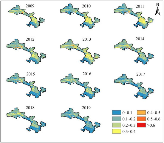
Figure 3.
Interannual mean spatial distribution of AOD from 2009 to 2019.
The annual mean AOD in Gansu Province from 2009 to 2019 exhibited significant changes. The high-value areas were mainly concentrated in the Hexi Corridor and Hedong region, while the low-value areas were distributed over the Qilian Mountains and Gannan Plateau. Before 2013, the high-AOD areas were larger, with regions exceeding 0.4 being more extensive; the AOD values in parts of the Hexi Corridor could reach over 0.6. After 2014, the provincial AOD values decreased significantly, and the low-value areas expanded continuously. Except for the western Hexi Corridor, the AOD values in other regions dropped to around 0.2.
The monthly mean AOD distribution (Figure 4) shows that high values primarily occurred from January to May, with the most extensive coverage in spring (March–April). Sparse vegetation, low precipitation, and high wind speeds during winter and spring easily trigger dust events. Additionally, coal burning during the heating season and the stable atmospheric conditions in the Hedong region during winter, which hinder pollutant dispersion, favor the formation of fine-mode aerosols. Consequently, high AOD values emerged in central Hedong from December, intensified in January, and peaked and expanded province-wide in April. After May, with increasing precipitation and vegetation coverage, the high AOD areas gradually diminished, and no significant high-value zones were evident from July to November.
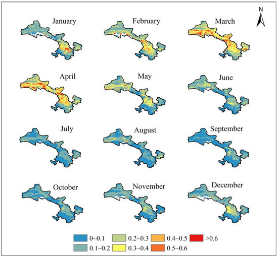
Figure 4.
Monthly mean spatial distribution of AOD from 2009 to 2019.
Simultaneously, AOD displayed significant seasonal differences. Spring exhibited the highest AOD, followed by winter, while summer and autumn were generally lower (both ≤0.4), with autumn being the lowest throughout the year. In spring, AOD was commonly ≥0.4 in the Hexi Corridor, central and eastern Hedong, with localized areas in the Hexi Corridor exceeding 0.6. The low-value areas were mainly located in the Qilian Mountains and Gannan Plateau. The prevalence of deserts and Gobi underlying surfaces in the Hexi Corridor, situated between the Qilian Mountains and the Beishan Mountains, leads to frequent spring dust storms, resulting in the accumulation of coarse dust aerosols [23,24], which is the primary reason for the high values. Furthermore, the characteristics of low precipitation and high wind speeds in winter affect soil moisture and surface roughness the following spring, further exacerbating dust aerosol concentrations [25,26]. In summer, weakened dust influence significantly reduced the extent of high AOD areas, mainly confined to the western Hexi Corridor. Larger particle sizes dominated central and eastern Hedong, while reduced dust events, increased precipitation, higher humidity, and greater vegetation coverage collectively contributed to lower AOD. Autumn had low dust frequency, with no significant high values in the Hexi Corridor; only central Hedong, characterized by dense population and developed economy, showed high-value areas with AOD ≤ 0.3. The lower AOD in summer and autumn is related to precipitation scavenging and relatively stable meteorological conditions. In winter, specific meteorological and geographical conditions, coupled with human activities, led to increased fine particulate matter; the valley topography in central Hedong facilitates pollutant accumulation, and stable atmospheric conditions hinder dispersion [27,28], resulting in heavier pollution in this region. Therefore, the natural background of sparse vegetation and high wind speeds, superimposed with anthropogenic factors like coal burning during the heating season, jointly cause the Hexi Corridor and central Hedong to be high AOD zones (locally >0.6).
Analysis based on the Mann–Kendall trend test and Theil–Sen slope estimator (Figure 5, Table 1) revealed regional differences in AOD changes across Gansu Province from 2009 to 2019. Overall, the vast majority of areas showed either a significant decreasing trend or no significant change. Areas with significant decrease accounted for 52.8%, and areas with no significant change accounted for 47.1%, mainly distributed across central Hexi Corridor, the Hedong region, eastern Gannan Plateau, northern Hexi Corridor, and Gannan Plateau. Areas showing an increasing trend were extremely limited (only 0.1%). Between 2009 and 2013, AOD generally showed no significant change or a significant increasing trend. Increasing areas (4.8%) expanded notably in eastern Hedong and the Hexi Corridor, primarily attributed to rapid economic development, sharp population density increases, and weak atmospheric environmental management. Since the implementation of the “Air Pollution Prevention and Control Action Plan” in September 2013, air quality has continuously improved province-wide, with decreasing particulate matter concentrations. From 2014 to 2019, AOD decreased significantly across the province, with areas showing no significant change or significant decrease accounting for 99.8%. The decreasing areas continued to expand, particularly significantly in the Hexi Corridor and eastern Hedong.
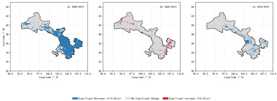
Figure 5.
Annual spatial variation trend of AOD in different stages.

Table 1.
Annual and seasonal trend change rates of AOD at different stages.
Seasonal trend analysis (Figure 6, Table 1) indicated that from 2009 to 2019, the vast majority of areas (>94%) in each season exhibited either no significant change or a decreasing trend in AOD, but with seasonal differences. Spring had the highest proportion of areas with a significant decrease (52.6%), mainly located in the central Hexi Corridor, most of Hedong, and eastern Gannan Plateau. Summer, autumn, and winter were predominantly characterized by areas with no significant change (accounting for 57.7%, 75.9%, and 77.9%, respectively). Among these, summer had the second-highest proportion of significant decrease (41.8%) after spring, concentrated in the eastern Hexi Corridor and most of Hedong. Autumn saw some expansion of increasing areas (4.6%), primarily distributed in the northern Hexi Corridor. Examining sub-periods, during 2009–2013, increasing areas expanded significantly in spring and autumn. Spring increases (4.3%) were distributed in the western Hexi Corridor, central-eastern Hedong, and western Gannan Plateau; autumn increases (5.7%) were found in most of the Hexi Corridor, central Hedong, and central Gannan Plateau. Decreasing areas expanded in summer (9.1%), but scattered increasing areas (0.5%) remained in the Hexi Corridor and Gannan Plateau. Winter was overwhelmingly dominated by no significant change (96.5%), with only scattered increases (0.4%) in the western Hexi Corridor. During 2014–2019, the spring increasing areas drastically decreased to 0.2%, scattered in the western Gannan Plateau, while no significant change (86.8%) and significant decrease (13.0%) dominated. In summer, only scattered increases (0.2%) occurred in the central Hexi Corridor, with 98.8% of the area showing a decrease or no change. Autumn had 95.4% of the area with no significant change, with only localized increases (1.0%). Winter had 99.5% of the area showing no significant change or decrease.
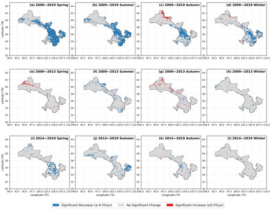
Figure 6.
Seasonal spatial variation trend of AOD in different stages.
3.2. Temporal Characteristics of AOD
Figure 7 shows that the annual mean AOD in Gansu Province from 2009 to 2019 fluctuated between 0.119 and 0.185. The highest value occurred in 2010 (0.185) and the lowest in 2019 (0.119). Overall, a slow decreasing trend is evident, with an annual decrease rate of 0.006, although the decreasing trend was not statistically significant (p > 0.05). Figure 6 also depicts the trend of seasonal mean AOD over the study period. All seasons exhibited decreasing trends. Spring and winter showed more pronounced fluctuations, with spring having the most significant decrease (annual rate: −0.013, R2 = 0.75). Autumn showed the gentlest decrease (annual rate: −0.002, R2 = 0.35). Spring AOD was significantly higher than other seasons, followed by winter, with autumn having the lowest values. This is related to frequent dust events in winter/spring and increased aerosol particles from coal burning during the heating period.
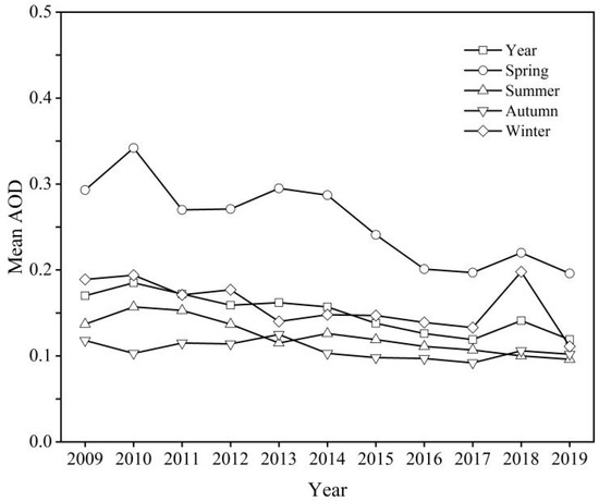
Figure 7.
Characteristics of interannual and seasonal variations in AOD from 2009 to 2019.
Figure 8 shows the monthly mean AOD trend from 2009 to 2019. Monthly AOD fluctuated between 0.091 and 0.293, exhibiting a “single-peak” pattern with seasonal periodicity. The maximum AOD occurred in April (0.293), while the minimum occurred in September (0.091). Values from February to May were higher than the annual mean (0.161), representing months with higher AOD. Other months had relatively low values. This pattern is associated with the dominance of large dust aerosols in Gansu, with spring being the peak season for dust events.
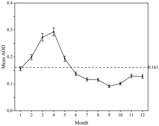
Figure 8.
Characteristics of monthly variations in AOD from 2009 to 2019.
3.3. Spatial Correlation Analysis Between AOD and Meteorological Factors
Figure 9 illustrates the spatial distribution of seasonal correlation coefficients between AOD and four meteorological factors in Gansu Province: planetary boundary layer height (PBLH), relative humidity at 2 m (RH2), temperature at 2 m (T2), and wind speed (WS). The results indicate that the spatiotemporal distribution of AOD in Gansu Province is closely related to meteorological factors, exhibiting distinct seasonal characteristics in spatial correlation.
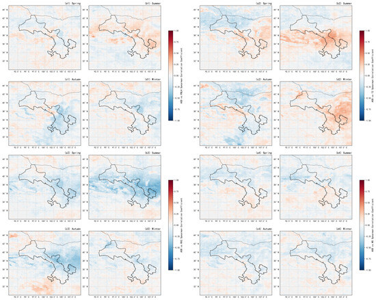
Figure 9.
Distribution maps of spatial correlation coefficients between AOD and meteorological factors across seasons (where (a1,b1,c1,d1) represent AOD vs. PBLH; (a2,b2,c2,d2) represent AOD vs. T2; (a3,b3,c3,d3) represent AOD vs. RH2; (a4,b4,c4,d4) represent AOD vs. WS).
Figure 9(a1,b1,c1,d1) show that in spring, AOD and PBLH exhibit a weak negative correlation over most of the province, with a weak positive correlation in the Qilian Mountains and western Gannan Plateau. In the Hexi Corridor, strong westerly winds and dry surfaces cause elevated PBLH to accelerate vertical dispersion of dust, thereby diluting aerosols. Conversely, in the Qilian Mountains and western Gannan Plateau, changes in surface albedo during snowmelt increase sensible heat flux, leading to local thermal uplift that retains dust [29]. In summer, the correlation shifts to positive over large areas (significantly so in the eastern tip of the Hexi Corridor and eastern Hedong), potentially due to the radiative effects of light-absorbing aerosols emitted from urban clusters in Hedong during summer, which suppress boundary layer development, forming a positive feedback loop [30]. Meanwhile, the Qilian Mountains and southwestern Gannan Plateau maintain a negative correlation due to weakened convection associated with lower temperatures. In autumn, negative correlation prevails in Hedong, Gannan Plateau, and northern Hexi Corridor, while the Qilian Mountains show weak positive correlation. Winter is characterized by weak negative correlation over most areas, with stronger negative correlation in the central Hexi Corridor, possibly related to basin topography enhancing temperature inversions, where compressed PBLH couples with heating emissions [31].
Figure 9(a2,b2,c2,d2) indicate that AOD and T2 exhibit mainly positive correlation in spring, summer, and winter, but predominantly negative correlation in autumn. In spring, positive correlation occurs in the central Hexi Corridor, Qilian Mountains, Hedong, and Gannan Plateau (strongest in the central Hexi Corridor), possibly due to surface warming triggering dust release from saline-alkali lands [32], while the northern Hexi Corridor shows negative correlation. In summer, high temperatures in Hedong’s industrial zones promote photochemical reactions, accelerating the formation of secondary organic aerosols (SOAs) from VOCs and NOx [33]. Coupled with topographical confinement (valleys/basins) facilitating SOA accumulation, this leads to increased AOD. Strong positive correlation is seen in Hedong, the eastern tip of Hexi Corridor, and eastern Qilian Mountains, with weak negative correlation in northern Hexi Corridor and southern Hedong. Autumn shows a negative correlation everywhere except for a weak positive in the Qilian Mountains. Winter patterns resemble summer but with weaker intensity. In autumn, cold air sinking into Qilian valleys creates shallow inversions hindering pollutant dispersion (AOD accumulation), while inversion weakening during cooling favors scavenging. In low-altitude areas (Hexi Corridor, Hedong), rapid surface cooling in autumn compared to the atmosphere increases vertical temperature gradients, triggering thermal turbulence. Simultaneously, temperature increases enhance convective mixing depth, accelerating aerosol vertical dispersion, resulting in a negative correlation. In winter, under low temperatures, a surge in anthropogenic heat emissions (heating/industry) coupled with boundary layer compression causes AOD to rise concurrently with temperature increases, forming a positive feedback loop [34].
Figure 9(a3,b3,c3,d3) reveal that AOD and RH2 exhibit predominantly negative correlation throughout the year. In spring and autumn, negative correlation is widespread (strongest in the central Hexi Corridor), except for weak positive correlation in the Gannan Plateau and northern Hexi Corridor. Summer shows province-wide negative correlation, most significant in the central Hexi Corridor, Qilian Mountains, and Hedong region. Winter negative correlation weakens but remains dominant. The perennial aridity in the central Hexi Corridor means humidity increases mainly accompany precipitation events, where wet deposition scavenging dominates the strong AOD-RH2 negative correlation [35]. Conversely, high humidity in the Gannan Plateau during spring and autumn promotes hygroscopic growth of sulfates, leading to localized positive correlation. In summer, the eastern Qilian Mountains, influenced by the northern edge of the East Asian monsoon, experience enhanced orographic precipitation, expanding the scope of wet scavenging. In winter, temperature inversions in Hedong inhibit water vapor diffusion, with a weak negative correlation reflecting reduced scavenging efficiency under low humidity [36].
Figure 9(a4,b4,c4,d4) show that AOD and WS exhibit predominantly negative correlation throughout the year. In spring, negative correlation dominates the Hexi Corridor and central-eastern Hedong, while the Gannan Plateau shows positive correlation. Summer features widespread negative correlation in the Hexi Corridor, with weak positive correlation in central Hedong and the Gannan Plateau. Autumn shows a negative correlation everywhere except for a weak positive in the Gannan Plateau. Winter exhibits a significant negative correlation in the Hexi Corridor, with weak correlation elsewhere. In spring, increased wind speed over the Gannan Plateau (grassland surface) lifts soil particles, causing a dust emission effect leading to AOD-WS positive correlation [37]. Conversely, strong winds in the Hexi Corridor (Gobi background) dilute anthropogenic emissions (negative correlation). In summer, topographical convergence in central Hedong causes weak wind perturbations within the inversion layer, briefly elevating AOD and creating positive correlation anomalies. In winter, the “canyon effect” on the northern slopes of the Qilian Mountains enhances wind speeds, with cold air drainage accelerating pollutant dispersion (strong negative correlation), while loess hills in southeastern Hedong weaken northwesterly winds, with weak correlation reflecting topographical obstruction of dynamics.
3.4. Relative Contributions of Local Emissions and Meteorological Factors to Seasonal AOD Variation
The seasonal variation in AOD in Gansu Province exhibits a significant dominance by emission factors (Figure 10a–d). Analysis based on multiple regression and LMG contribution decomposition indicates that in 80% of seasonal scenarios (13/16), emission factor components (PM2.5, , , , OM, and BC) contributed over 50% relative to AOD. Specifically, the Hexi Corridor is emission-dominated year-round (winter: 71%, spring: 51%, summer: 81%, and autumn: 95%). The Hedong region is also consistently controlled by emissions (winter: 68%, spring: 67%, summer: 80%, and autumn: 80%). The Gannan Plateau is emission-dominated in spring (69%) and summer (72%). Intra-group contribution decomposition of emission factors shows the following: Black Carbon (BC) contributed over 30% in 11 seasons, peaking in Hedong summer (52.5%) and Gannan Plateau summer (46.2%). Nitrate () and ammonium () synergistically contributed over 57% in Hexi Corridor summer and autumn (summer: 36.3%, 36.3%; autumn: 21.3%). Organic Matter (OM) was significant in the Gannan Plateau summer (20.3%) and province-wide spring (19.0%). In contrast, meteorological factors dominated only in specific regions and seasons: Gannan Plateau winter (82% contribution, T2: 65.8%, RH2: 20.8%) and autumn (61% contribution, T2: 78.1%), and Gansu Province summer (67% contribution, RH2: 63.2%, WS: 20.7%).
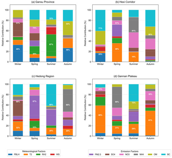
Figure 10.
Relative contribution rates of meteorological factors and emission factors to AOD across regions and seasons.
The apparent dominance of emission factors fundamentally stems from the coupling of dust and anthropogenic emissions. Firstly, dust, as a physical substrate, directly contributes 30–68% to PM2.5 mass (e.g., Hexi spring: 68 ± 5%, autumn: 57 ± 4%). Since dust is categorized as a broad “emission factor” in the analysis, its contribution is statistically included, rather than representing the true anthropogenic contribution (e.g., dust contributed 44.3% to PM2.5 in Hexi spring) [38]. Secondly, dust mineral surfaces (e.g., α-Fe2O3) can catalyze heterogeneous reactions (e.g., ), increasing formation rates by 5–8 times in summer [39], resulting in a hidden increment exceeding 15%. Furthermore, dust interacts with anthropogenic pollutants to form composite particles: (1) BC-dust core–shell structures can reduce single-scattering albedo [40], enhancing boundary layer heating (e.g., contributing 58.9% to PBLH in Hexi winter), thereby suppressing pollutant dispersion; (2) Under relative humidity >60%, dust particles loaded with and can swell upon deliquescence [41], leading to a doubling of extinction efficiency. Regional differences reflect varying coupling intensities: the Hexi Corridor uses dust as a perennial substrate (>48% of PM2.5 mass), carrying agricultural (spring: 13.7%) and industrial BC (autumn: 33.9%). The high emission intensity in Hedong surpasses the scavenging capacity of meteorology, while also relying on long-range dust transport and its interfacial catalysis, forming an emission-dominated pattern year-round. The Gannan Plateau, with high vegetation coverage (>60%), weakens dust influence (<35% of PM2.5 mass), primarily dominated by BC-OM from biomass burning (summer: combined 66.5%). Meteorological factors indirectly regulate these processes by modulating dust activity: high summer humidity province-wide promotes liquid water content, accelerating secondary particle formation via aerosol aqueous-phase reactions; low winter temperatures in the Gannan Plateau weaken turbulent exchange, combined with a shallow boundary layer (PBLH < 500 m), forming an inversion cap that traps local biomass burning emissions (BC/) [42].
Given the differing contributions of natural (dust) and anthropogenic sources to AOD variation, governance strategies require region-specific approaches: (1) Dust-Dependent Regions (Hexi Corridor): Focus on disrupting the dust-pollutant interaction chain. Promote farmland mulching and spraying Fe3+ chelating agents during spring sowing to inhibit SO2 heterogeneous reactions on dust surfaces [39]. Implement straw return during autumn harvest to reduce soil dust resuspension. (2) Anthropogenically Dominated Regions (Hedong): Prioritize source emission reduction. Upgrade industrial coal-burning dust removal facilities and promote clean fuel alternatives in the summer. Promote slow-release fertilizers and precision fertilization techniques in autumn to reduce NH3 volatilization. (3) Ecologically Fragile Regions (Gannan Plateau): Develop efficient, clean combustion technologies for biomass stoves to reduce BC and OM emissions. Implement drought-tolerant shrub reseeding on degraded grasslands to improve surface coverage.
Future research needs to establish a “natural–anthropogenic” dual-track attribution model to precisely identify true anthropogenic components (e.g., industrial BC in Hedong) and dust-dependent anthropogenic components (e.g., on dust carriers in Hexi), providing a scientific basis for regionally differentiated governance.
4. Discussion
The spatial pattern of AOD in Gansu Province distinctly presents a dichotomy of “high values in Hexi Corridor-Central vs. low values in Qilian Mountains-South,” profoundly reflecting the coupling of topographic gradients (altitude difference > 3000 m) and human activity intensity [43]. The province-wide expansion of high-value areas in spring stems from dual drivers: frequent dust events triggered by westerly circulation in the Hexi Corridor (contributing 72 ± 8% of annual dust AOD during March–May), and overlapping emissions from delayed heating seasons and industrial resumption in the Hedong region. The retreat of high-value areas in summer and autumn confirms the synergistic effect of monsoon precipitation scavenging and enhanced boundary layer convection [8]. The “unimodal” evolution of AOD at the monthly scale further reveals the dominance of climatic system rhythms—winter inversion layers compressing diffusion space, dry and windy spring conditions facilitating dust uplift, and enhanced summer precipitation scavenging collectively form a phase-locked annual cycle framework [44].
The turning point in AOD trends from 2009 to 2019 highlights the effect of policy intervention. Before 2013, the stage of extensive economic growth led to significant AOD increases in the Hedong industrial zone and Hexi energy corridor [45]. Following the implementation of the “Air Pollution Prevention and Control Action Plan”, province-wide emission reduction projects drove a surge in the proportion of AOD-decreasing areas to 99.8% during 2014–2019, notably in central Hexi and eastern Hedong. Significantly, the highest proportion of significant decrease areas in spring (52.6%) is directly linked to dust control achievements: farmland coverage and dust suppression projects in mining areas implemented in the Hexi region reduced the contribution of dust AOD. The localized increase phenomenon in autumn (4.6%) exposes shortcomings in agricultural ammonia emission control, as straw burning and fertilizer application enhance the formation of secondary ammonium salt aerosols [46].
Meteorological factors modulate AOD spatial differentiation through “dynamic–thermodynamic–chemical” pathways. In the arid zone (Hexi Corridor), the strong negative RH2 correlation year-round highlights the core role of wet deposition, while the positive T2 correlation in spring reflects surface warming triggering dust release from saline-alkali lands. The strong negative WS correlation in winter and spring reflects the dispersion advantage of pollutants under strong winds, but the local dust-raising effect leads to a positive WS correlation on the Gannan Plateau in spring. In the industrial zone (Hedong), the summer PBLH positive feedback arises from a dual mechanism: the radiative effect of light-absorbing BC suppresses boundary layer development, while high temperatures accelerate photochemical oxidation, generating secondary sulfates [33]. The uniqueness of the alpine zone (Gannan Plateau) lies in the following: winter low temperatures (T2 contribution 65.8%) promote local accumulation of BC-OM from biomass burning by weakening turbulent exchange and compressing the boundary layer; weak positive RH2 correlations in spring and autumn are attributed to hygroscopic growth of sulfate increasing extinction efficiency. The apparent dominance of emission factors requires disentanglement from natural source interference: dust contributes 48–68% to PM2.5 in Hexi, and its mineral surfaces catalyze heterogeneous reactions, increasing summer formation rates by 5–8 times [39], leading to systematic overestimation of anthropogenic contributions. Core anthropogenic components exhibit regional specificity: summer BC contribution reached 52.5% in Hedong industrial zone, stemming from coal-fired power plants and heavy-duty diesel trucks; synergistic – contributions > 57% in Hexi agricultural belt summer/autumn are linked to fertilizer application and livestock NH3 release; and biomass burning on the Gannan Plateau drives summer BC-OM peaks (together accounting for 66.5%). Meteorological dominance occurs only in sensitive region–season combinations: winter low temperatures on the Gannan Plateau (T2 contribution 65.8%) double the accumulation efficiency of local biomass burning emissions by inhibiting turbulent diffusion and enhancing inversion capping; province-wide summer high humidity (RH2 contribution 63.2%) amplifies the mass fraction of secondary inorganic particles through aerosol aqueous-phase reactions.
The distinct spatial pattern of AOD in Gansu Province revealed in this study—characterized by high values in the Hexi Corridor and central regions versus low values in the Qilian Mountains and southern areas—aligns closely with the findings of Chen et al. [47] for Lanzhou and its surroundings. Their retrieval using a custom aerosol model identified a persistent AOD high-value center (>0.35) over the Xigu industrial zone, while ecological areas like Xinglong Mountain and Liujiaxia Reservoir exhibited consistently low values (<0.15), confirming the dual regulation of industrial emissions and topographic shielding on aerosol spatial heterogeneity. However, this study further elucidates the seasonal expansion mechanism of high-value zones: the spring high-AOD area covered 83% of the province, significantly exceeding the localized scope (within ~100 km of Lanzhou) observed by Chen et al. This discrepancy is attributed to the synergistic effects of cross-regional dust transport (Hexi) and industrial emissions (Hedong).
Regarding temporal variations, the unimodal monthly AOD pattern observed here (peak value of 0.293 in April) corroborates the results of Zhao et al. [48] based on MODIS C6 data for Northwest China, who also noted an April peak (0.35 ± 0.038) and autumn minimum across the region. However, our study finds that the spring peak intensity in Gansu (0.293) is significantly lower than in the Taklimakan Desert source region (0.35), highlighting the gradient in aerosol loading between dust source and non-source areas. Notably, the post-2013 annual decline rate of AOD in Gansu (0.32%/yr) exceeds the 0.26%/yr trend reported by Zhao et al. for Northwest China (2010–2015), indicating that Gansu’s improvement rate surpassed other parts of the region following the implementation of the Air Pollution Prevention and Control Action Plan.
Concerning driving mechanisms, Zhang et al. [49] previously emphasized that the correlation between AOD and the Air Pollution Index (API) in Lanzhou required correction for humidity and aerosol scale height. This study deepens this understanding: through quantitative decomposition of emission and meteorological contributions, we found that BC contributed up to 52.5% to AOD in the Hedong industrial zone during summer—substantially higher than their earlier estimate of 30–35%. This difference arises from enhanced chemical formation of secondary organic aerosols (SOAs) under high temperatures, a pathway insufficiently considered in earlier models. Furthermore, this work is the first to reveal the dominant role of winter temperature (T2) in regulating AOD over the Gannan Plateau (82% contribution), moving beyond previous studies focused solely on anthropogenic emissions and providing new insights for pollution control in alpine regions.
This study has certain limitations in data and methodology, such as the lack of aerosol vertical profiles and the coarse spatial resolution of NCEP data. In future work, we will employ vertical observation data and the HYSPLIT backward trajectory model to analyze pollution transport pathways and potential source regions. We will further integrate CALIPSO observations with WRF-Chem simulations to quantify transboundary transport fluxes, and combine isotope fingerprinting with machine learning attribution models to quantify the implicit contribution of anthropogenic components adsorbed onto dust carriers. These approaches aim to provide targeted pathways for cross-regional joint prevention and control.
5. Conclusions
Utilizing MODIS AOD data and NCEP reanalysis data from 2009 to 2019, this study investigated the spatial distribution characteristics and trends of AOD over Gansu Province at monthly, seasonal, and annual scales, while quantitatively analyzing the influence of meteorological and emission factors on its distribution. The main conclusions are as follows:
- (1)
- Influenced by altitude, topography, and human activities, the spatial distribution of AOD in Gansu Province exhibits distinct regional differences. High AOD values are mainly concentrated in the Hexi Corridor and central regions, while low values are distributed in the Qilian Mountains and southern regions. The spatial extent of high AOD values is largest in spring, essentially recedes in summer and autumn, and begins to expand gradually in winter. Monthly mean distributions show that a high AOD center forms in southeastern Gansu in January, expands northward in February, covers almost the entire province by March, peaks in April, begins to shrink in May, and forms a relatively high-value area in central and eastern regions by December.
- (2)
- AOD changes in Gansu Province from 2009 to 2019 exhibited significant regional and temporal differences. Overall, AOD across the province was dominated by significant decreases (52.8%) or remained essentially unchanged (47.1%), with increasing areas accounting for only 0.1%, mainly distributed in the central Hexi Corridor, Hedong region, and eastern Gannan Plateau. By period, during 2009–2013, AOD was generally stable or significantly increasing (increasing areas accounted for 4.8%, concentrated in eastern Hedong and the Hexi Corridor), and attributed to rapid economic growth, sharp population density increase, and weak atmospheric environmental management. After the implementation of the “Air Pollution Prevention and Control Action Plan” in September 2013, air quality continuously improved from 2014 to 2019, with AOD significantly decreasing (99.8% stable or decreasing). Decreasing areas expanded persistently in the Hexi Corridor and eastern Hedong region. Seasonally, AOD remained stable or decreased in the vast majority of areas (>94%) in all seasons. However, the proportion of areas with significant decreases was highest in spring (52.6%), while increasing areas expanded somewhat in autumn (4.6%). The sub-period analyses showed that during 2009–2013, increasing areas expanded significantly in spring and autumn (4.3% and 5.7%, respectively), decreasing areas expanded in summer (9.1%), and stable conditions dominated in winter (96.5%). In contrast, during 2014–2019, increasing areas plummeted to less than 1.0% in all seasons, with stable or decreasing trends overwhelmingly dominant (95.4–99.5%), indicating that policy intervention effectively promoted stable regional air quality improvement.
- (3)
- From 2009 to 2019, AOD in Gansu Province ranged between 0.119 and 0.185, showing an overall slow decreasing trend. Spring AOD was generally higher than in other seasons, but its decreasing trend was also the most pronounced. Monthly mean AOD fluctuated between 0.091 and 0.293, exhibiting a “unimodal” variation pattern.
- (4)
- Spatially, the Hexi Corridor is characterized by strong negative RH2 correlations year-round, strong negative WS correlations in winter and spring, significant positive T2 correlation in spring, and negative T2 correlation in the north in summer. The Hedong region is marked by a prominent positive PBLH correlation in summer, strong positive T2 correlations in spring and summer, and consistently negative RH2 correlations. The Gannan Plateau exhibits positive WS correlation in spring, weak positive RH2 correlations in spring and autumn, positive T2 correlation in spring, and negative T2 correlation in autumn. Seasonally, PBLH showed weak negative correlations over most areas in spring (local positive correlations in Qilian Mountains and Gannan Plateau), shifted to significant positive correlation in Hedong but negative in Hexi/Gannan in summer, and was mostly negative in autumn and winter. RH2 was predominantly negatively correlated year-round, but showed weak positive correlations in the Gannan Plateau during spring and autumn. T2 showed mainly positive correlations in spring and summer (strong positive in central Hexi spring and strong positive in Hedong summer), shifted to mostly negative in autumn (except weak positive in Qilian Mountains), and showed a weak positive correlation in winter. WS showed negative correlations dominating year-round, but a positive correlation in the Gannan Plateau spring, weak positive in summer, strong negative in the Hexi winter, and weak correlations elsewhere. Overall, the association between AOD and meteorological factors exhibits distinct gradient differentiation across the arid zone (Hexi), industrial zone (Hedong), and alpine zone (Gannan). Notably, PBLH positive correlation occurs only in summer Hedong, T2 negative correlation concentrates in autumn, and WS positive correlation is limited to the warm season in Gannan, highlighting the decisive regulatory role of regional underlying surface properties on meteorological effects.
- (5)
- In 80% of seasonal scenarios (13 out of 16), emission factors (PM2.5, , , , OM, and BC) contributed over 50% to AOD. Emissions dominated year-round in the Hexi Corridor (71% to 95%) and Hedong region (68% to 80%), and in spring (69%) and summer (72%) on the Gannan Plateau. Regarding component contributions, BC contributed over 30% in 11 seasons (e.g., 52.5% in Hedong summer and 46.2% in Gannan summer); and synergistically contributed over 57% in Hexi summer and autumn; and OM played a significant role in Gannan summer (20.3%) and province-wide spring (19.0%). Meteorological factors dominated only in specific scenarios: Gannan Plateau winter (82%) and autumn (61%), dominated by T2; and province-wide summer (67%), dominated by RH2 and WS.
Author Contributions
Methodology, F.H. and C.G.; software, F.H., B.Z. and H.L.; data analysis, F.H., C.J. and C.Z.; writing—original draft, F.H., J.F. and X.Z.; writing—review and editing, F.H. and W.M.; funding acquisition, C.G. and X.Z. All authors have read and agreed to the published version of the manuscript.
Funding
This research was funded by the National Natural Science Foundation of China (NSFC) General Program (42375085 and U2242208); Gansu Provincial Natural Science Foundation (22JR5RA749); Open Research Projects of Key Laboratory of Atmospheric Chemistry, China Meteorological Administration (2024B02).
Data Availability Statement
The original contributions presented in the study are included in the article, further inquiries can be directed to the corresponding author.
Acknowledgments
We are grateful to the anonymous reviewers and editors for appraising our manuscript and offering instructive comments. We acknowledge NASA for providing MODIS aerosol products (https://ladsweb.modaps.eosdis.nasa.gov/, accessed on 10 July 2023) and the National Centers for Environmental Prediction (NCEP) for the FNL reanalysis data (https://rda.ucar.edu/datasets/ds083.3/, accessed on 8 May 2024). We sincerely thank the scientific teams for their efforts in producing and distributing these datasets.
Conflicts of Interest
The authors declare no conflicts of interest.
References
- Li, C.; Mao, J.; Lau, A.K.H. Remote Sensing Aerosol with MODIS and the Application of MODIS Aerosol Products. Acta Sci. Nat. Univ. Pekin. 2003, 39, 108–117. [Google Scholar] [CrossRef]
- Ramanathan, V.; Li, F.; Ramana, M.V.; Praveen, P.S.; Kim, D.; Corrigan, C.E.; Nguyen, H.; Stone, E.A.; Schauer, J.J.; Carmichael, G.R.; et al. Atmospheric brown clouds: Hemispherical and regional variations in long-range transport, absorption, and radiative forcing. J. Gephysical Res. Atmos. 2007, 112, D22S21. [Google Scholar] [CrossRef]
- Li, Z.Q.; Niu, F.; Fan, J.W.; Liu, Y.G.; Rosenfeld, D.; Ding, Y.N. Long-term impacts of aerosols on the vertical development of clouds and precipitation. Nat. Geosci. 2019, 12, 888–894. [Google Scholar] [CrossRef]
- Liu, H.; Gao, X.M.; Xie, Z.Y.; Li, T.T.; Zhang, W.J. Spatio-temporal characteristics of aerosol optical depth over Beijing-Tianjin-Hebei-Shanxi-Shandong region during 2000–2013. Acta Sci. Circumstantiae 2015, 35, 1506–1511. [Google Scholar] [CrossRef]
- Zhang, S.; Wu, J.; Fan, W.X.; Yang, Q.D.; Zhao, D.M. Review of aerosol optical depth retrieval using visibility data. Earth-Sci. Rev. 2020, 200, 102986. [Google Scholar] [CrossRef]
- Stefanie, H.I.; Radovici, A.; Mereuta, A.; Arghius, V.; Camarasan, H.; Costin, D.; Botezan, C.; Ginsca, C.; Ajtai, N. Variation of Aerosol Optical Properties over Cluj-Napoca, Romania, Based on 10 Years of AERONET Data and MODIS MAIAC AOD Product. Remote Sens. 2023, 15, 3072. [Google Scholar] [CrossRef]
- Gui, K.; Che, H.Z.; Chen, Q.; Zeng, Z.; Zheng, Y.; Long, Q.; Sun, T.; Liu, X.; Wang, Y.; Liao, T. Water vapor variation and the effect of aerosols in China. Atmos. Environ. 2017, 165, 322–335. [Google Scholar] [CrossRef]
- Luo, Y.X.; Zheng, X.B.; Zhao, T.L.; Chen, J. Climatology of aerosol optical depth over China from recent 10 years of MODIS remote sensing data. Ecol. Environ. Sci. 2012, 21, 876–883. [Google Scholar] [CrossRef]
- Tie, X.X.; Wu, D.; Brasseur, G. Lung cancer mortality and exposure to atmospheric aerosol particles in Guangzhou, China. Atmos. Environ. 2009, 43, 2375–2377. [Google Scholar] [CrossRef]
- Schäfer, K.; Thomas, W.; Peters, A.; Ries, L.; Obleitner, F.; Schnelle-Kreis, J.; Birmili, W.; Diemer, J.; Fricke, W.; Junkermann, W.; et al. Influences of the 2010 Eyjafjallajökull volcanic plume on air quality in the northern Alpine region. Atmos. Chem. Phys. 2011, 11, 8555–8575. [Google Scholar] [CrossRef]
- Chen, X.F.; de Leeuw, G.; Arola, A.; Liu, S.M.; Li, Z.Q.; Zhang, K.N. Joint retrieval of the aerosol fine mode fraction and optical depth using MODIS spectral reflectance over northern and eastern China: Artificial neural network method. Remote Sens. Environ. 2020, 249, 112006. [Google Scholar] [CrossRef]
- Zhang, Y.; Xiao, Z.Y. Temporal-Spatial Variations Characteristics of Aerosol Optical Thickness using Satellite Remote Sensing over Yunnan Province, China. Environ. Monit. China 2016, 32, 127–133. [Google Scholar] [CrossRef]
- Wang, C.Y.; He, M.Q.; Chen, J.H.; Liu, Z.H. Temporal and Spatial Variation Characteristics of MODIS Aerosol Optical Depth in Sichuan Basin from 2006 to 2017. Res. Environ. Sci. 2020, 33, 54–62. [Google Scholar] [CrossRef]
- Zhang, M.; Wang, Y.; Ma, Y.Y.; Wang, L.C.; Gong, W.; Liu, B.M. Spatial distribution and temporal variation of aerosol optical depth and radiative effect in South China and its adjacent area. Atmos. Environ. 2018, 188, 120–128. [Google Scholar] [CrossRef]
- Wang, W.B.; Zhu, D.Y.; Jing, C.S.; Guo, X.G.; Chen, L. Spatial distribution and temporal variation of aerosol optical depth in the Western Pacific Ocean. Dyn. Atmos. Ocean. 2022, 99, 101303. [Google Scholar] [CrossRef]
- Seema, R.; Rajesh, K. Spatial distribution of aerosol optical depth over India during COVID-19 lockdown phase-1. Spat. Inf. Res. 2022, 30, 417–426. [Google Scholar] [CrossRef]
- Che, H.Z.; Xia, X.G.; Zhao, H.J.; Li, L.; Gui, K.; Zheng, Y.; Song, J.J.; Qi, B.; Zhu, J.; Miao, Y.C.; et al. Aerosol optical and radiative properties and their environmental effects in China: A review. Earth-Sci. Rev. 2024, 248, 104634. [Google Scholar] [CrossRef]
- Zhang, X.; Li, L.; Che, H.; Dubovik, O.; Derimian, Y.; Holben, B.; Gupta, P.; Eck, T.F.; Lind, E.S.; Toledano, C. Aerosol Components Derived from Global AERONET Measurements by GRASP: A New Value-Added Aerosol Component Global Dataset and Its Application. Bull. Am. Meteorol. Soc. 2024, 105, E1822–E1848. [Google Scholar] [CrossRef]
- Mayila, R.; Ding, J.L.; Zhang, Z.; Zhang, Z.H.; Chen, X.Y.; Liu, S.Y. Spatiotemporal distribution characteristics and potential sources of aerosol optical depth in Urumqi. Acta Sci. Circumstantiae 2020, 40, 1611–1620. [Google Scholar]
- Huang, F.F.; Ma, W.Q.; Wang, S.C.; Feng, C.; Kong, X.Y.; Liu, H. Analysis and Validation of the Aerosol Optical Depth of MODIS Products in Gansu Province, Northwest China. Remote Sens. 2023, 15, 2972. [Google Scholar] [CrossRef]
- Li, Y.Y.; Zhang, A.P.; Li, H.Y.; Wang, F.; Chen, Y.; Zeng, T. Relationship between Boundary Layer Height and Wind-sand Intensities over Hexi Corridor, China. J. Desert Res. 2019, 39, 11–20. [Google Scholar] [CrossRef]
- Ren, G.P.; Wei, Y.P.; Ke, W.; Qiao, G.; Wan, Z.X.; Liang, X.G. Characteristics of Atmospheric-boundary-layer Height and Its Relationship with Sand-dust Weather in Jiuquan of Gansu Province. J. Arid. Meteorol. 2020, 38, 979–986. [Google Scholar] [CrossRef]
- Huang, Y.; Chen, B.; Dong, L.; Zhang, Z.J. Analysis of a Dust Weather Process over East Asia in MAY 2019 Based on Satellite and Ground-Based Lidar. Chin. J. Atmos. Sci. 2021, 45, 524–538. [Google Scholar] [CrossRef]
- Li, Y.Y.; Zhang, C.Y.; Zhang, A.P.; Yang, J.P.; Chen, Y.; Nie, X. Vertical structure characteristics of atmospheric boundary layer in spring sandstorm over Hexi Corridor. Meteormon 2022, 48, 1171–1185. [Google Scholar] [CrossRef]
- Zhang, J.; Guo, N.; Di, X.H. Analysis on Precipitation in Winter and Relation with Sand Days in Northwest Region. J. Desert Res. 2004, 5, 87–90. [Google Scholar]
- Ding, K.; Liu, J.P. Spatial distribution dynamic changes of sand storm in northern China in recent 50 years. J. Arid. Land Resour. Environ. 2011, 25, 116–120. [Google Scholar] [CrossRef]
- Zhang, X.Y. Characteristics of the chemical components of aerosol particles in the various regions over China. Acta Meteoroligica Sin. 2014, 72, 1108–1117. [Google Scholar] [CrossRef]
- Li, M.Q. Formation Potential and Pollution Characteristics of Secondary Organic Aerosol in Lanzhou, China. Master’s Thesis, Lanzhou University, Lanzhou, China, 2021. [Google Scholar] [CrossRef]
- Li, J.C.; Pang, G.J.; Wang, X.J.; Liu, F.; Zhang, Y.T. Spatiotemporal Dynamics of Land Surface Albedo and Its Influencing Factors in the Qilian Mountains, Northeastern Tibetan Plateau. Remote Sens. 2022, 14, 1922. [Google Scholar] [CrossRef]
- Cheng, Z.G.; Pan, Y.B.; Li, J.; Jia, X.C.; Zhang, X.Y.; Ma, P.K.; Wang, Q.Q.; Dou, J.X.; Zhang, J.J.; Quan, J.N. Assessing the Influence of Aerosol on Radiation and Its Roles in Planetary Boundary Layer Development. J. Meteorol. Res. 2021, 35, 384–392. [Google Scholar] [CrossRef]
- Sha, B.N.; Yang, Y.H.; Huang, F.J.; Ye, M. Spatial and temporal distribution characteristics of the temperature inversion in Northwest China. Arid. Zone Res. 2025, 42, 397–408. [Google Scholar] [CrossRef]
- Chen, S.; Huang, J.; Kang, L.; Wang, H.; Ma, X.; He, Y.; Yuan, T.; Yang, B.; Huang, Z.; Zhang, G. Emission, transport, and radiative effects of mineral dust from the Taklimakan and Gobi deserts: Comparison of measurements and model results. Atmos. Chem. Phys. 2017, 17, 1–43. [Google Scholar] [CrossRef]
- Ning, Q.; He, M.; Ji, Y.Y.; Yin, H.; Li, J.D.; Shang, F.Y.; Zhang, K. Characteristics and Formation of Complex Air Pollution and Sources of VOCs in the Yellow River Delta Region. Res. Environ. Sci. 2024, 37, 439–454. [Google Scholar] [CrossRef]
- Chen, B.; Wu, C.; Liu, X.; Chen, L.; Wu, J.; Yang, H.; Luo, T. Seasonal climatic effects and feedbacks of anthropogenic heat release due to global energy consumption with CAM5. Clim. Dyn. 2019, 52, 6377–6390. [Google Scholar] [CrossRef]
- Zhang, F. Factors Influencing the Spatio–Temporal Variability of Aerosol Optical Depth over the Arid Region of Northwest China. Atmos. 2024, 15, 54. [Google Scholar] [CrossRef]
- Lv, X.H.; Tang, Z.Y.; Lv, W.W.; Tang, Y.Q.; Xie, X.H.; Tan, D.Q. Climate Characteristics Analysis and Forecast of Fog and Haze over Shaoyang in the Past 70 Years. Clim. Change Res. Lett. 2018, 7, 102–109. [Google Scholar] [CrossRef]
- Sayer, A.M.; Smirnov, A.; Hsu, N.C.; Holben, B.N. A pure marine aerosol model, for use in remote sensing applications. J. Geophys. Res. Atmos. 2012, 117, D05213. [Google Scholar] [CrossRef]
- Guo, C.Y.; Wang, Y.; Liu, H.; Liu, Y.; Wang, S.T.; Li, B. Spatial and temporal distribution characteristics and transport path analysis of regional particulate matter over Gansu Province. China Environ. Sci. 2021, 41, 3990–4000. [Google Scholar]
- Cui, H.X.; Cheng, T.T.; Yu, X.N.; Chen, J.M.; Xu, Y.F.; Fang, W. Laboratory simulation of SO2 heterogeneous reactions on hematite surface under different SO2 concentrations. J. Environ. Sci. 2009, 21, 1103–1107. [Google Scholar] [CrossRef]
- Tiwari, P.; Cohen, J.B.; Wang, X.Y.; Wang, S.; Qin, K. Radiative Forcing Bias Calculation Based on COSMO (Core—Shell MIE model Optimization) and AERONET data. NPJ Clim. Atmos. Sci. 2023, 6, 193. [Google Scholar] [CrossRef]
- Wu, C.; Zhang, S.; Wang, G.H.; Lv, S.J.; Li, D.P.; Liu, L.; Li, J.J.; Liu, S.J.; Du, W.; Meng, J.J. Efficient Heterogeneous Formation of Ammonium Nitrate on the Saline Mineral Particle Surface in the Atmosphere of East Asia during Dust Storm Periods. Environ. Sci. Technol. 2020, 54, 15622–15630. [Google Scholar] [CrossRef]
- Zhang, Y.L.; Zuo, H.C.; Gao, X.Q.; Fan, G.Z.; Lv, S.H.; Hua, W.; Dong, L.X. Evolution Characteristics of the Flows Around the Tibetan Plateau and the Relationship with the Climate in China in Winter. Front. Earth Sci. 2022, 10, 978995. [Google Scholar] [CrossRef]
- Yin, Z.L.; Feng, Q.; Zhu, R.; Wang, L.G.; Chen, Z.X.; Fang, C.S.; Lu, R. Analysis and prediction of the impact of land use/cover change on ecosystem services value in Gansu province, China. Ecol. Indic. 2023, 154, 110868. [Google Scholar] [CrossRef]
- Anquetin, S.; Guilbaud, C.; Chollet, J.P. Thermal valley inversion impact on the dispersion of a passive pollutant in a complex mountainous area. Atmos. Environ. 1999, 33, 3953–3959. [Google Scholar] [CrossRef]
- Liu, Z.; Zhang, H.; Zhang, Y.J.; Zhu, T.T. How does industrial policy affect the eco-efficiency of industrial sector? Evidence from China. Applied Energy 2020, 272, 115206. [Google Scholar] [CrossRef]
- Yi, W.Y.; Liu, G.P.; Wang, M.; Wang, J.; Chen, D.L.; Shen, J.L. Increased nitrogen deposition and airborne particulate matter pollution in the vicinity of intensive animal farms caused by ammonia emissions. Agric. Ecosyst. Environ. 2025, 387, 109634. [Google Scholar] [CrossRef]
- Chen, Y.; Sun, J.Z.; Zhang, W.; Meng, X.W.; Wang, J.; Sun, J.Z. Research on the correlation between MODIS aerosol optical depth and air pollution index over Lanzhou area. J. Lanzhou Univ. 2013, 49, 765–772. [Google Scholar] [CrossRef]
- Zhao, S.W.; Gao, X.Q. Study of aerosol optical depth and angstrom exponent in the northwest of China based on MODIS product. J. Atmos. Environ. Opt. 2017, 12, 321–331. [Google Scholar] [CrossRef]
- Zhang, X.H.; Zhang, W.; Chen, Y.; Feng, J.J.; Bi, J.R.; Shi, J.S.; Zhang, B.D.; Huang, J.P. Retrieval of aerosol optical depth with a custom aerosol model over Lanzhou and its surroundings. Plateau Meteorol. 2013, 32, 402–410. [Google Scholar] [CrossRef]
Disclaimer/Publisher’s Note: The statements, opinions and data contained in all publications are solely those of the individual author(s) and contributor(s) and not of MDPI and/or the editor(s). MDPI and/or the editor(s) disclaim responsibility for any injury to people or property resulting from any ideas, methods, instructions or products referred to in the content. |
© 2025 by the authors. Licensee MDPI, Basel, Switzerland. This article is an open access article distributed under the terms and conditions of the Creative Commons Attribution (CC BY) license (https://creativecommons.org/licenses/by/4.0/).