1. Introduction
Recently, the acceleration of climate change has brought various environmental issues to the forefront. Issues such as sea level rise and an increased frequency of extreme climatic events are among the prominent consequences, and are significantly affecting ecological systems [
1,
2,
3]. For example, sea level rise and temperature increases are contributing to elevated salinity in coastal regions, thereby inducing ecological shifts [
4,
5]. These changes are especially detrimental to mangrove ecosystems, which are highly sensitive to salinity fluctuations. Furthermore, climate change is leading to a progressive reduction in both the abundance and spatial extent of tree species that are native to high-altitude environments [
6]. As the effects of climate change intensify, the role of carbon sequestration has gained growing attention as a key mitigation strategy [
7,
8]. Globally, the significance of carbon sequestration is increasingly acknowledged. Forest, marine, and coastal ecosystems serve as the primary environments for carbon uptake, making critical contributions to both carbon storage and sequestration processes [
9]. Notably, marine and coastal ecosystems are especially vital. Mangroves, coral reefs, and seagrasses are now widely seen as key blue-carbon sinks. Protecting these ecosystems has become one of the leading strategies in the fight against climate change [
10,
11].
Mangroves establish distinct ecological systems and exhibit superior carbon sequestration capabilities compared to many other tree species. As such, they are recognized worldwide as one of the most prominent contributors to blue-carbon storage [
12]. At the 2015 United Nations Framework Convention on Climate Change (UNFCCC), several key developing nations formally committed to employing mangrove ecosystem restoration and conservation as a climate change mitigation measure [
13]. The total carbon storage of mangroves worldwide is estimated to be approximately 11.7 Pg C, with about 84% of this amount being stored in soil organic carbon [
14]. Mangrove ecosystems in tropical regions sequester an average of 1023 Mg of carbon per hectare (ha) in both vegetation and soil, a figure that exceeds the carbon storage capacity of typical tropical forests more than threefold [
15]. Furthermore, mangrove ecosystems are integral in mitigating the adverse effects of climate change, serving to protect coastal zones from storm surges and counteracting sea level rise through the accumulation of organic material [
16]. Mangrove ecosystems support 790 bird species, 40 mammal species, 20 reptile species, and 3 amphibian species. Of these, 48 bird species, 14 reptile species, 1 amphibian species, and 6 mammal species are heavily reliant on mangroves for their habitat and survival [
17]. Mangrove ecosystems are presently facing ongoing degradation. The global extent of mangrove ecosystems was estimated to be approximately 152,604 km
2 in 2020. Over the 24-year period from 1996 to 2020, approximately 3.4% of mangrove cover was lost due to coastal erosion, aquaculture expansion, oil palm plantations, logging, and land-use conversion [
18]. The degradation of mangrove ecosystems results in reduced carbon storage, a loss of biodiversity, and heightened flood risks from rising sea levels, among other problems, thereby necessitating urgent conservation efforts [
19].
However, due to the high density and coastal habitat of mangrove forests, access by humans is often difficult. To overcome this challenge, various remote sensing-based studies have been conducted to analyze mangroves and build spatial data for these ecosystems [
20,
21,
22]. Thus, remote sensing via satellites, drones, and aircraft makes it possible to map the spatial distribution of mangroves over large and often inaccessible areas. However, while high-resolution data are essential for the effective conservation and management of mangrove forests in developing countries, access to costly commercial satellite imagery is often limited [
23]. In these situations, open-access satellite imagery datasets such as Landsat and Sentinel-2 are essential tools for researchers and policy developers in developing nations [
24]. These open datasets are easy to access, regularly updated, and include past satellite records, thus making it possible to conduct time-series analysis. In addition, new techniques for the enhanced analysis and application of remote sensing data are continually being developed.
Recently, machine learning and deep learning approaches have been widely applied in remote sensing studies, particularly for land cover classification and tree species identification. Machine learning, which uses data-driven algorithms to simulate human iterative learning, has seen significant advances in terms of both accuracy and efficiency over the past few decades. The artificial neural network (ANN) has further developed into deep learning algorithms with remarkable capability in handling large-scale datasets and identifying intricate patterns [
25]. Various deep learning architectures have been developed, including the convolutional neural network (CNN), fully convolutional network (FCN), and U-Net. These architectures exhibit unique features and advantages, and the selection of an appropriate model should be guided by the specific analysis goals and data characteristics. For instance, CNNs are particularly effective for feature extraction from images, which makes them suitable for tasks such as classification and detection. They are widely used in image classification and object detection applications. Meanwhile, FCN and U-Net architectures are more adept at pixel-level prediction, which makes them highly effective for image segmentation and satellite image analysis [
26].
The present study is aimed at assessing the spatial distribution of mangrove habitats in the Solomon Islands by combining remote sensing and deep learning techniques. By utilizing open-source data, the study aims to provide more accurate information than that found in existing datasets, thereby facilitating the development of more precise protection strategies. In particular, the study utilizes freely available resources such as Sentinel-2 satellite imagery and ESA WorldCover to create mangrove detection data for the Solomon Islands with improved accuracy compared to previous global-scale mangrove detection datasets. The study provides an effective analytical methodology for use in developing countries and delivers essential scientific spatial information for the identification of priority mangrove protection areas via hotspot analysis. The study’s objective is to propose a methodology for the selection of priority mangrove protection areas. It is anticipated that the findings will contribute to mangrove protection policies in the Solomon Islands and other similar Pacific Island nations.
4. Discussion
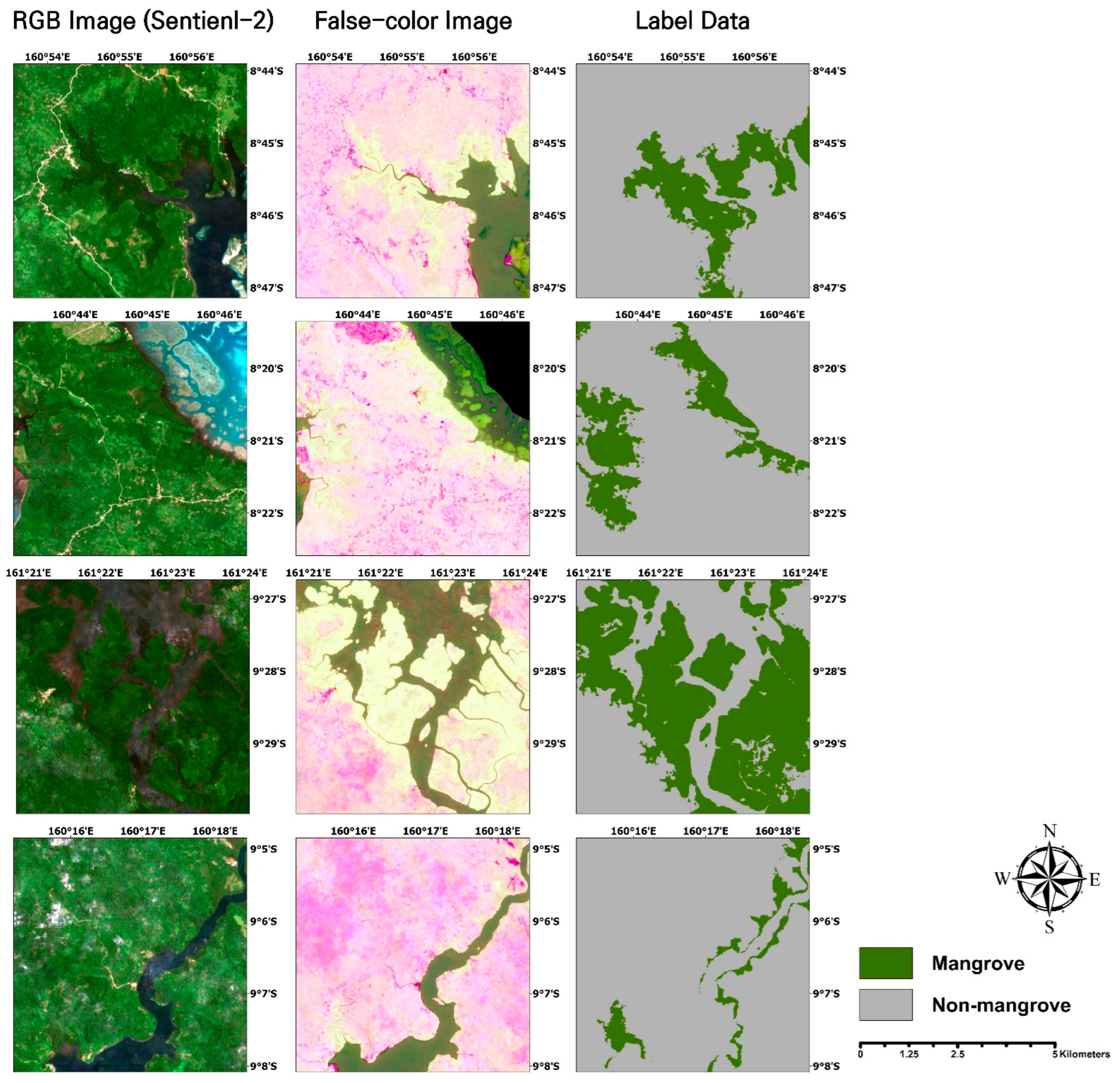
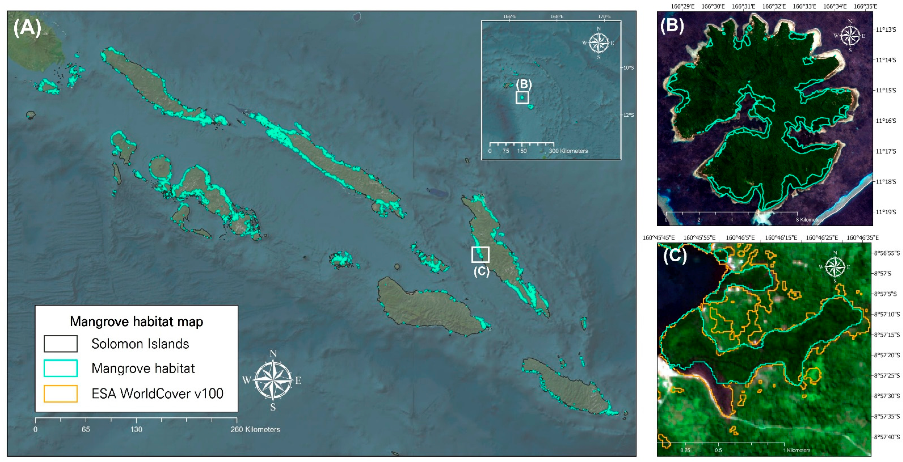
The mangrove habitat mapping results obtained through the application of the proposed analytical methodology achieved an overall accuracy of 0.96, thereby outperforming the ESA WorldCover v100 and Global Mangrove Watch v3.0 datasets, which were found to have overall accuracies of 0.744 and 0.931, respectively. Additionally, the proposed model identified mangrove habitat areas that were not detected by ESA WorldCover v100, thus highlighting its superior mapping performance [
18,
61]. This can be attributed to the integration of open-source satellite data and labeled ground truth data, and the application of mangrove indices that reflect local ecological characteristics.
While ESA WorldCover v100 applies a globally standardized classification framework using a CatBoost-based gradient boosting model trained on over 130 features derived from Sentinel-1 Synthetic Aperture Radar and Sentinel-2 time series, along with additional variables such as DEM, vegetation indices, and ecoregions, the WorldCover product also incorporates expert rules and auxiliary datasets during post-processing to refine its predictions. ESA WorldCover v100 applies a standardized classification algorithm globally, while the present study adopted a localized approach using open-source resources, thereby enabling optimized analysis in data-scarce regions such as developing countries. In contrast, the mangrove habitat detection model is based on a U-Net convolutional neural network trained on false-color composite imagery generated from three mangrove-specific indices, which enhances mangrove-specific spectral signals but does not utilize the same volume of multi-source input data or expert-driven post-processing as WorldCover. These results demonstrate that the proposed methodology provides a cost-efficient and effective tool for environmental management and protection efforts, including mangrove distribution analysis, by leveraging open-source data. Given that it does not rely on expert-driven rule-based post-processing or additional datasets, the approach holds significant potential for application in regions with limited data and resources. However, since this study focused exclusively on the Solomon Islands, additional cross-validation with datasets from other geographic regions and varying ecological conditions is essential to assess the generalizability and robustness of the proposed methodology.
The study utilized multiple evaluation metrics to assess the model performance and classification accuracy. Specifically, precision, recall, and F1-score were applied to evaluate the detection capability of the model, while the mangrove classification map was validated using a comprehensive set of metrics, including the above three along with the overall accuracy, mean IoU, QD, and AD. The adoption of diverse evaluation criteria ensured that the performance assessment was not biased by a single metric, thereby allowing for an objective evaluation of the model’s accuracy.
Despite the overall effectiveness of the proposed model, a notable limitation is its relatively low detection accuracy for mangrove areas compared to non-mangrove areas. This discrepancy is primarily attributed to an imbalance in the training data, as mangrove samples were underrepresented. Specifically, mangrove areas account for only about 2.47% of the total land area in the Solomon Islands, resulting in a significantly smaller proportion of mangrove pixels during the training data generation process. As a result, the model was exposed to far fewer mangrove samples, which likely contributed to the lower model performance observed for the mangrove class. Additionally, the lower performance of the mangrove class compared to the non-mangrove class led to the underestimation of mangrove extent relative to non-mangrove areas.
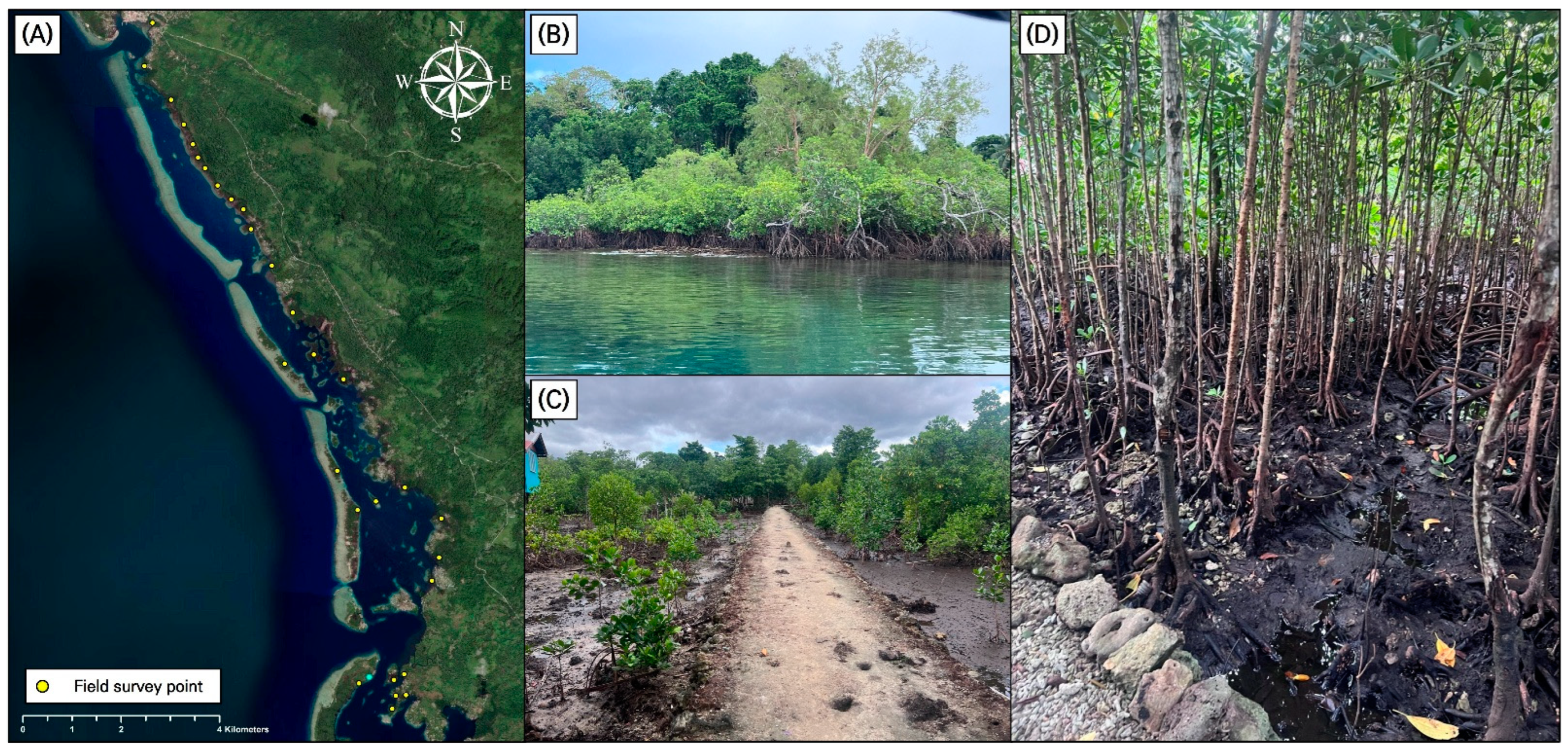
Although field surveys were conducted to supplement the validation data with ground truth data, the data collection was confined to the Langa Langa Lagoon, and no ground truth data were available for other regions of the Solomon Islands. Furthermore, due to the lack of sufficient field survey data, ground truth could not be incorporated into the training dataset. This limitation hindered our ability to validate the model comprehensively across the entire study area. To date, a comprehensive national-scale vegetation survey has not been conducted in the Solomon Islands, and obtaining sufficient ground truth data remains challenging due to the significant time and resource requirements. To overcome this limitation, local-community-based mapping is proposed as a practical alternative that leverages the knowledge and participation of local communities to facilitate data collection and validation in a cost- and time-efficient manner [
62]. This approach is particularly suitable for regions where access to conventional field surveys is limited. Through this approach, it will be necessary to secure additional ground truth data in the future to improve model performance by addressing the imbalance in the training dataset.
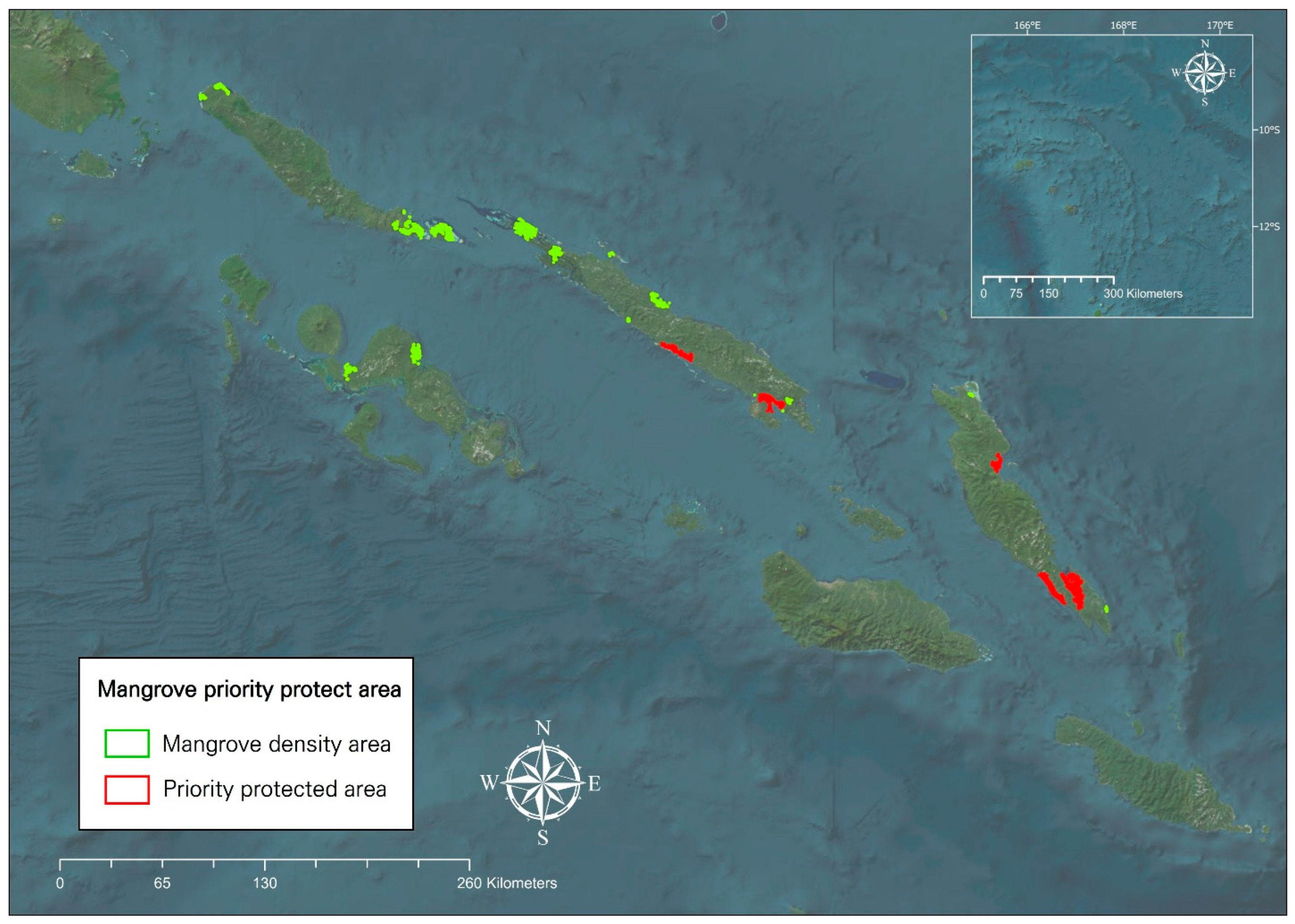
To designate mangrove priority protection areas and support policy decision-making processes, the present study conducted an analysis using a scientific approach based on optimized hotspot analysis, including the proximity to roads and built-up areas, and the total mangrove area. The analysis confirmed the presence of densely distributed mangrove regions in specific areas. Notably, all identified high-density mangrove zones were located in close proximity to roads, thereby indicating a heightened vulnerability to human disturbance. Considering that mangrove degradation in the Solomon Islands is predominantly driven by anthropogenic factors, it is imperative that these areas be prioritized for protection in order to mitigate further loss. The outcomes of this research offer valuable insights for the formulation of effective protection strategies and may serve as a baseline for future protection planning and policy development. However, the analysis presented herein relied solely on mangrove classification data, without incorporating additional dimensions such as biodiversity, ecosystem services, or socio-demographic variables, which remains a limitation of the present study.
In recent years, there has been growing interest in the development of simplified and accessible methodologies for rapid environmental assessments in developing countries [
63,
64,
65]. The approach proposed herein does not rely on costly remote sensing sources such as aerial imagery, drones, or high-resolution satellite data; instead, it is based on freely available open-source datasets and utilizes a time-efficient model architecture. This demonstrates the potential for practical application of the methodology in protection planning and coastal management within resource-limited settings. The optimized hotspot analysis conducted herein identified potential mangrove protection areas across the Solomon Islands. Currently, mangroves in the Solomon Islands cover approximately 71,348.27 ha, corresponding to about 2.47% of the country’s territory. These mangrove ecosystems are primarily concentrated in Choiseul, Isabel, and Malaita Provinces, as confirmed by the hotspot analysis. However, there are no designated mangrove protection areas in the Solomon Islands. While mangroves are nominally protected under the Resources and Timber Utilization Act, they are increasingly exploited for firewood, timber, boat construction, fish traps, and roofing materials. This has resulted in ongoing degradation driven by overexploitation and urban expansion [
29]. These results suggest the urgent need for the establishment of nationally managed mangrove protection areas and comprehensive coastal management regulations, supported by continuous monitoring and conservation efforts.
Unlike many previous studies that relied on traditional machine learning techniques, this study applied a deep learning-based U-Net model for mangrove habitat detection [
66,
67,
68]. In addition, unlike approaches that used vegetation indices, this study enhanced classification performance by utilizing a composite image derived from three mangrove-specific indices [
69,
70]. This approach enabled the model to detect mangrove areas more precisely, which are often difficult to identify using global mangrove datasets. Furthermore, rather than relying on expensive data sources such as high-resolution satellite imagery or UAVs, the proposed framework is built on freely accessible open-source datasets [
71,
72]. This cost-efficient approach provides a practical alternative that is suitable for application in developing countries where technical and financial resources are limited. These methodological distinctions offer a foundation for developing effective conservation strategies even in data- and resource-constrained settings.
Building on the methodology proposed herein, future research may focus on developing more refined conservation strategies for the Solomon Islands by incorporating a climate-change based mangrove habitat suitability analysis. The mid- to long-term designation of mangrove protection areas and the establishment of coastal management policies could be significantly enhanced by accounting for projected sea level rise, temperature variation, and shifts in precipitation patterns under different climate change scenarios. As these environmental factors directly influence the spatial distribution of mangrove habitats, their integration into habitat modeling frameworks will be crucial for informed decision-making processes. The prediction of future mangrove distributions based on climate change projections and the tailoring of protection strategies to regional conditions will be essential for effective and sustainable conservation planning.


