
Fine-Grained Land Use Remote Sensing Mapping in Karst Mountain Areas Using Deep Learning with Geographical Zoning and Stratified Object Extraction

Abstract
1. Introduction
2. Materials
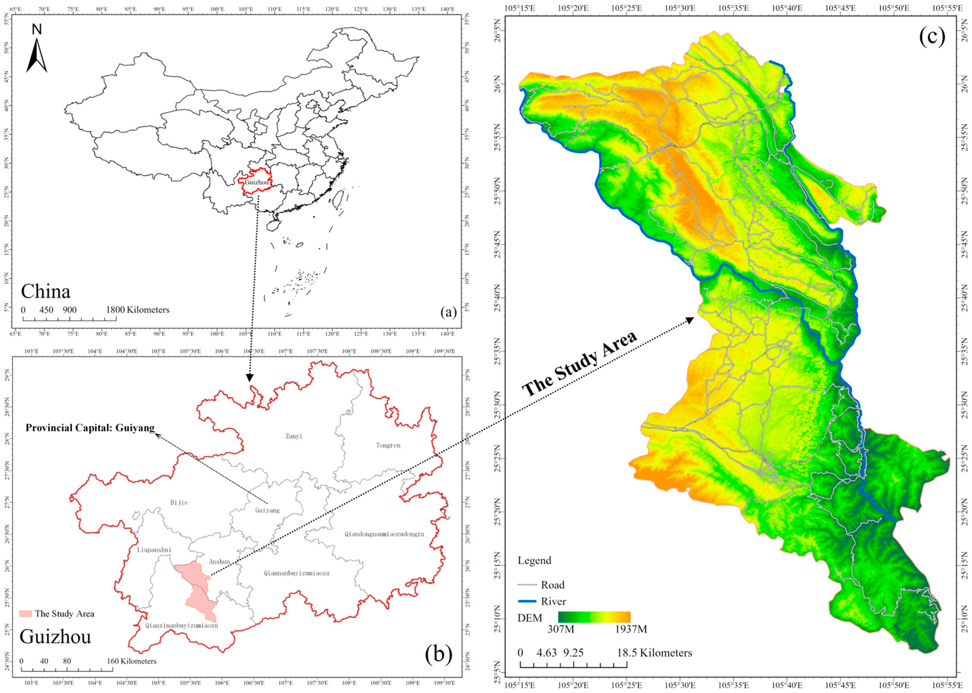
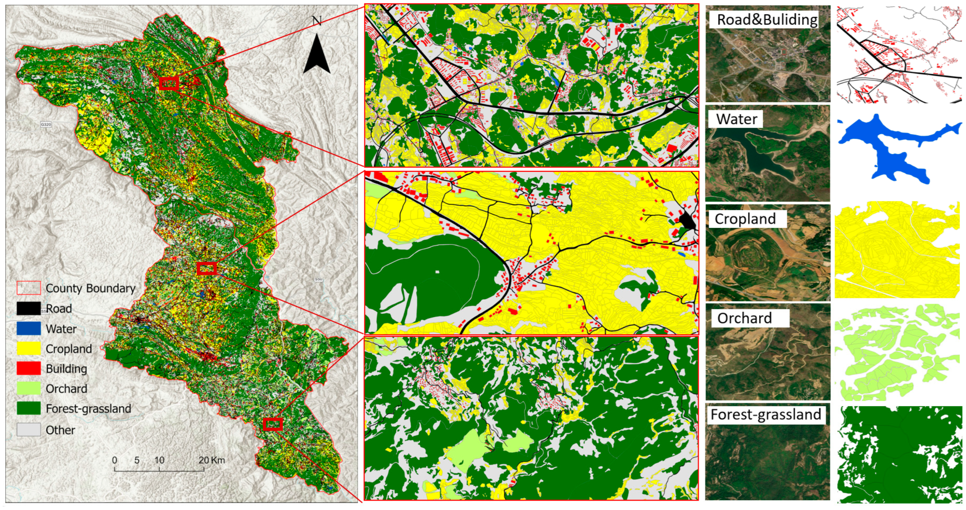
2.1. Study Area
2.2. Datasets
3. Methods and Experiment
3.1. Methods
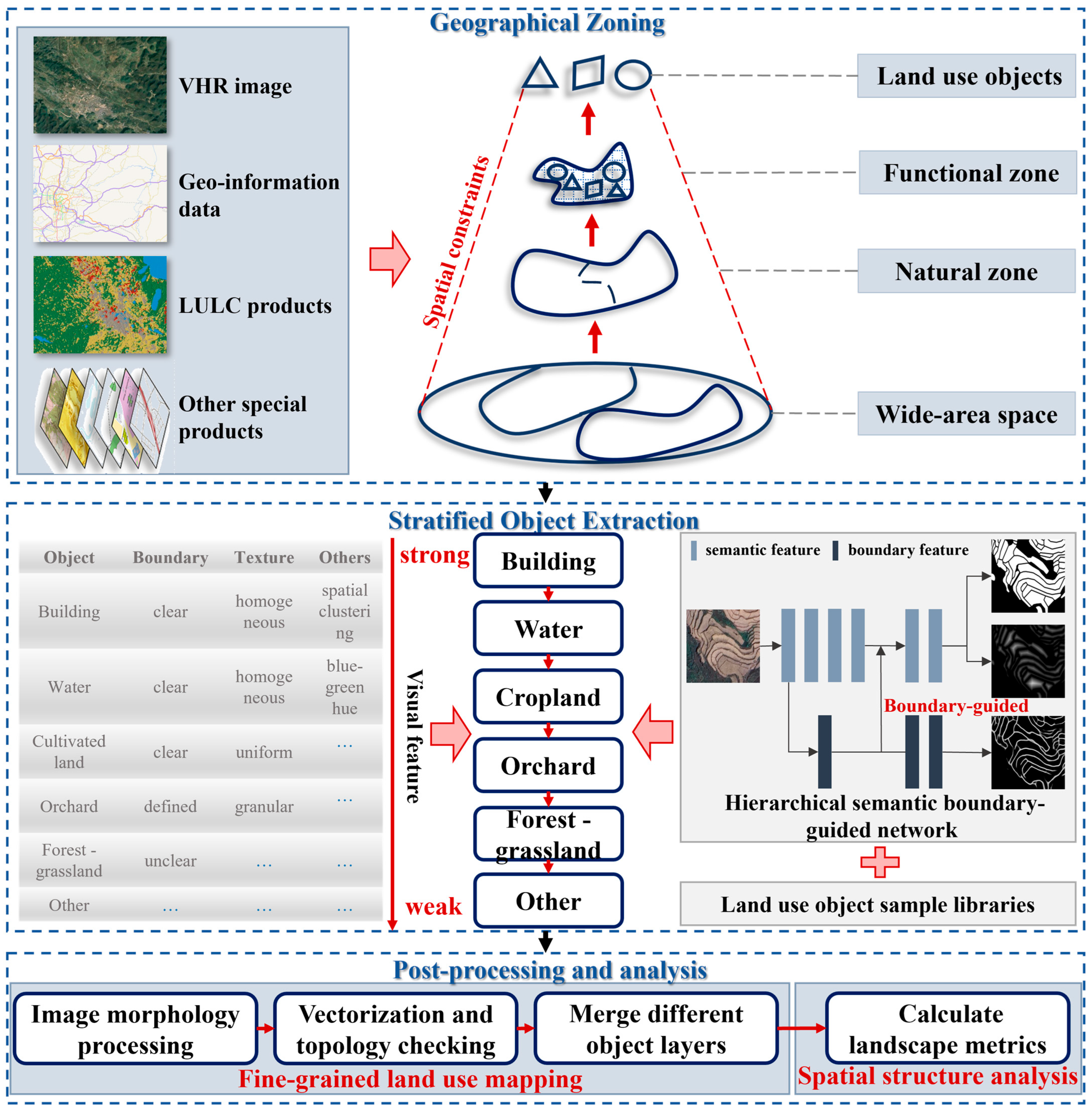
3.1.1. Geographical Zoning
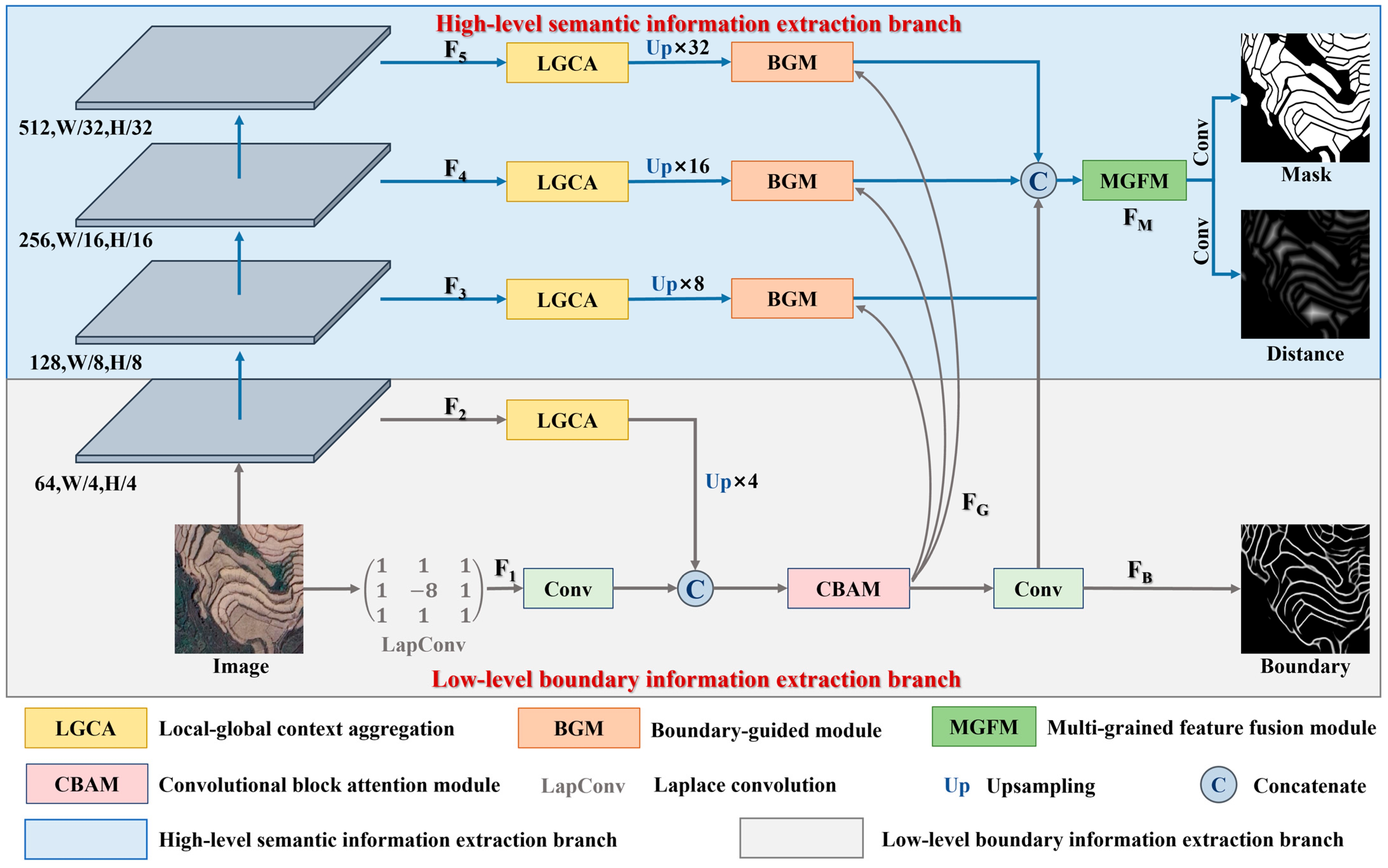
3.1.2. Stratified Object Extraction
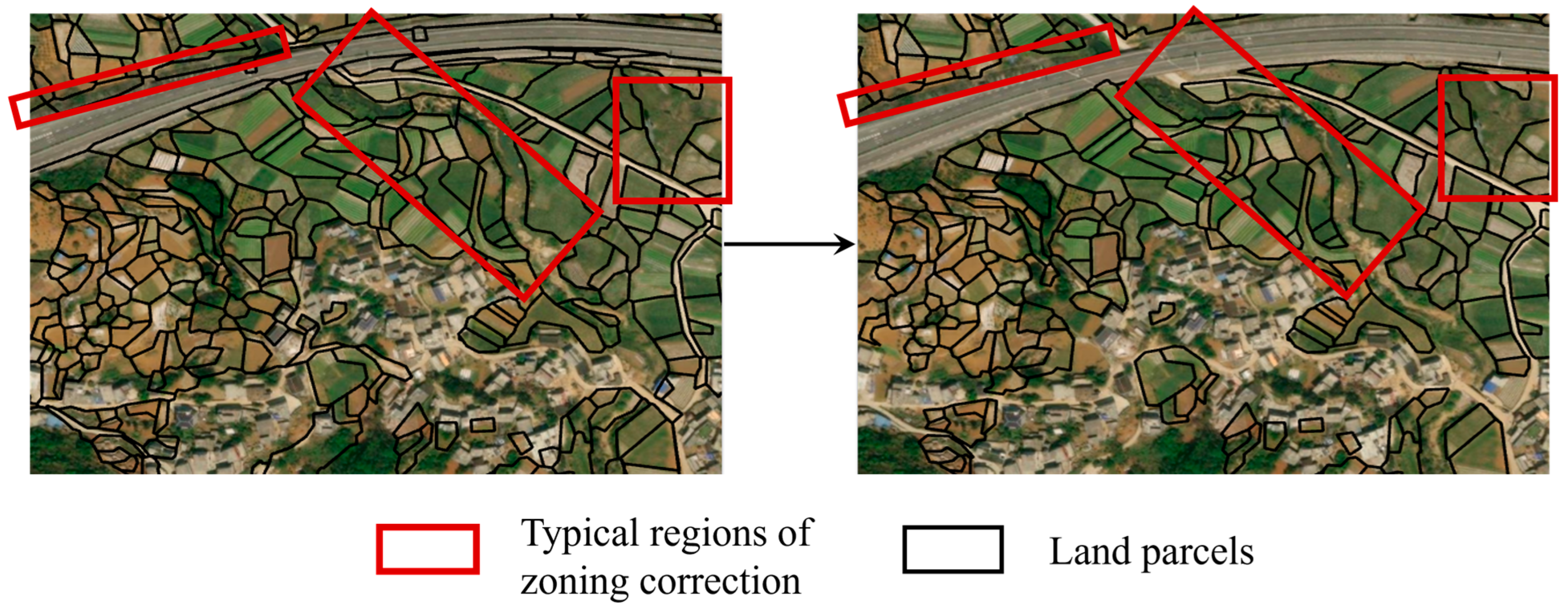
3.1.3. Post-Processing and Analysis
3.2. Experiment
4. Results and Analysis
4.1. Accuracy Evaluation Analysis
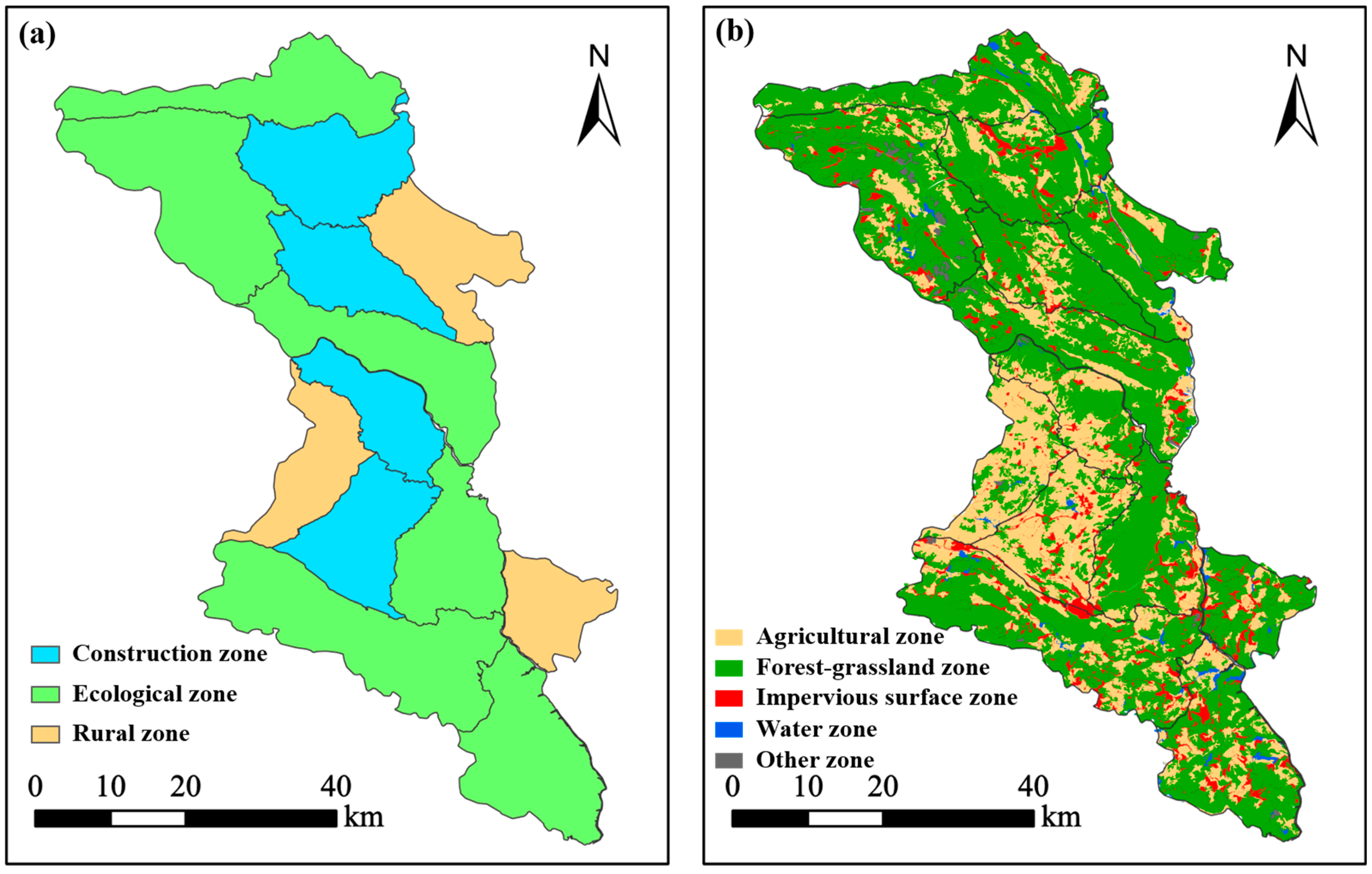
4.2. Spatial Structure Analysis
5. Discussions
5.1. Comparative Analysis
5.2. The Value of Mapping Results
6. Conclusions
Author Contributions
Funding
Data Availability Statement
Acknowledgments
Conflicts of Interest
Abbreviations
| VHR | Very high resolution |
| RS | Remote sensing |
| DL | Deep learning |
References
- Ford, D.; Williams, P. Karst Hydrogeology and Geomorphology; John Wiley & Sons, Inc.: New Jersey, NJ, USA, 2007; ISBN 978-7-5625-3784-7. [Google Scholar]
- Tang, J.; Tang, X.; Qin, Y.; He, Q.; Yi, Y.; Ji, Z. Karst Rocky Desertification Progress: Soil Calcium as a Possible Driving Force. Sci. Total Environ. 2019, 649, 1250–1259. [Google Scholar] [CrossRef]
- Wang, K.; Zhang, C.; Chen, H.; Yue, Y.; Zhang, W.; Zhang, M.; Qi, X.; Fu, Z. Karst Landscapes of China: Patterns, Ecosystem Processes and Services. Landsc. Ecol. 2019, 34, 2743–2763. [Google Scholar] [CrossRef]
- Hu, Z.; Wang, S.; Bai, X.; Luo, G.; Li, Q.; Wu, L.; Yang, Y.; Tian, S.; Li, C.; Deng, Y. Changes in Ecosystem Service Values in Karst Areas of China. Agric. Ecosyst. Environ. 2020, 301, 107026. [Google Scholar] [CrossRef]
- Chen, J.; Yu, J.; Bai, X.; Zeng, Y.; Wang, J. Fragility of Karst Ecosystem and Environment: Long-Term Evidence from Lake Sediments. Agric. Ecosyst. Environ. 2020, 294, 106862. [Google Scholar] [CrossRef]
- Liu, S.; Wang, Z.; Wu, W.; Yu, L. Effects of Landscape Pattern Change on Ecosystem Services and its Interactions in Karst Cities: A Case Study of Guiyang City in China. Ecol. Indic. 2022, 145, 109646. [Google Scholar] [CrossRef]
- Li, Q.; Bao, Y.; Wang, Z.; Chen, X.; Lin, X. Trade-Offs and Synergies of Ecosystem Services in Karst Multi-Mountainous Cities. Ecol. Indic. 2024, 159, 111637. [Google Scholar] [CrossRef]
- Zhou, Z.; Wang, L.; Chen, Q.; Luo, J.; Zhao, X.; Zhang, S.; Zhang, W.; Liao, J.; Lyu, Z. Abandoned Land Identification in Karst Mountain Area Based on Time Series SAR Characteristics at Geo-Parcels Scale. J. Mt. Sci. 2023, 20, 792–809. [Google Scholar] [CrossRef]
- Blaschke, T. Object Based Image Analysis for Remote Sensing. ISPRS J. Photogramm. Remote Sens. 2010, 65, 2–16. [Google Scholar] [CrossRef]
- Wang, Z.; Yang, X.; Liu, Y.; Liu, B.; Zhang, J.; Liu, X.; Meng, D.; Gao, K.; Zeng, X.; Ding, Y. Geographical Principles of Remote Sensing Image Analysis and the Hierarchical Patch Model Based Analysis Framework. Natl. Remote Sens. Bull. 2024, 28, 1412–1424. [Google Scholar] [CrossRef]
- Zhao, H.; Wu, B.; Zhang, M.; Long, J.; Tian, F.; Xie, Y.; Zeng, H.; Zheng, Z.; Ma, Z.; Wang, M.; et al. A Large-Scale VHR Parcel Dataset and a Novel Hierarchical Semantic Boundary-Guided Network for Agricultural Parcel Delineation. ISPRS J. Photogramm. Remote Sens. 2025, 221, 1–19. [Google Scholar] [CrossRef]
- Lu, R.; Zhang, Y.; Huang, Q.; Zeng, P.; Shi, Z.; Ye, S. A Refined Edge-Aware Convolutional Neural Networks for Agricultural Parcel Delineation. Int. J. Appl. Earth Obs. Geoinf. 2024, 133, 104084. [Google Scholar] [CrossRef]
- Long, J.; Li, M.; Wang, X.; Stein, A. Delineation of Agricultural Fields Using Multi-Task BsiNet from High-Resolution Satellite Images. Int. J. Appl. Earth Obs. Geoinf. 2022, 112, 102871. [Google Scholar] [CrossRef]
- Hossain, M.D.; Chen, D. Performance Comparison of Deep Learning (DL)-Based Tabular Models for Building Mapping Using High-Resolution Red, Green, and Blue Imagery and the Geographic Object-Based Image Analysis Framework. Remote Sens. 2024, 16, 878. [Google Scholar] [CrossRef]
- He, T.; Chen, J.; Kang, L.; Zhu, Q. Evaluation of Global-Scale and Local-Scale Optimized Segmentation Algorithms in GEOBIA with SAM on Land Use and Land Cover. IEEE J. Sel. Top. Appl. Earth Obs. Remote Sens. 2024, 17, 6721–6738. [Google Scholar] [CrossRef]
- Huang, Z.; Yang, X.; Liu, Y.; Wang, Z.; Ma, Y.; Jing, H.; Liu, X. Multi-Type Change Detection and Distinction of Cropland Parcels in High-Resolution Remote Sensing Images Based on Segment Anything Model. Remote Sens. 2025, 17, 787. [Google Scholar] [CrossRef]
- Hossain, M.D.; Chen, D. Segmentation for Object-Based Image Analysis (OBIA): A Review of Algorithms and Challenges from Remote Sensing Perspective. ISPRS J. Photogramm. Remote Sens. 2019, 150, 115–134. [Google Scholar] [CrossRef]
- Ez-zahouani, B.; Teodoro, A.; El Kharki, O.; Jianhua, L.; Kotaridis, I.; Yuan, X.; Ma, L. Remote Sensing Imagery Segmentation in Object-Based Analysis: A Review of Methods, Optimization, and Quality Evaluation over the Past 20 Years. Remote Sens. Appl. Soc. Environ. 2023, 32, 101031. [Google Scholar] [CrossRef]
- Minaee, S.; Boykov, Y.; Porikli, F.; Plaza, A.; Kehtarnavaz, N.; Terzopoulos, D. Image Segmentation Using Deep Learning: A Survey. IEEE Trans. Pattern Anal. Mach. Intell. 2022, 44, 3523–3542. [Google Scholar] [CrossRef]
- Zhang, X.; Xiao, P.; Feng, X. Object-Specific Optimization of Hierarchical Multiscale Segmentations for High-Spatial Resolution Remote Sensing Images. ISPRS J. Photogramm. Remote Sens. 2020, 159, 308–321. [Google Scholar] [CrossRef]
- Ma, L.; Liu, Y.; Zhang, X.; Ye, Y.; Yin, G.; Johnson, B.A. Deep Learning in Remote Sensing Applications: A Meta-Analysis and Review. ISPRS J. Photogramm. Remote Sens. 2019, 152, 166–177. [Google Scholar] [CrossRef]
- Aleissaee, A.A.; Kumar, A.; Anwer, R.M.; Khan, S.; Cholakkal, H.; Xia, G.-S.; Khan, F.S. Transformers in Remote Sensing: A Survey. Remote Sens. 2023, 15, 1860. [Google Scholar] [CrossRef]
- Yi, Y.; Zhang, Z.; Zhang, W.; Zhang, C.; Li, W.; Zhao, T. Semantic Segmentation of Urban Buildings from VHR Remote Sensing Imagery Using a Deep Convolutional Neural Network. Remote Sens. 2019, 11, 1774. [Google Scholar] [CrossRef]
- Chen, X.; Jiang, W.; Qi, H.; Liu, M.; Ma, H.; Yu, P.L.H.; Wen, Y.; Han, Z.; Zhang, S.; Cao, G. Adaptive Meta-Knowledge Transfer Network for Few-Shot Object Detection Very High-Resolution Remote Sensing Images. Int. J. Appl. Earth Obs. Geoinf. 2024, 127, 103675. [Google Scholar] [CrossRef]
- Sharma, S.; Gosain, A. Addressing Class Imbalance in Remote Sensing Using Deep Learning Approaches: A Systematic Literature Review. Evol. Intell. 2025, 18, 23. [Google Scholar] [CrossRef]
- Zhang, Z.; Jing, W.; Li, H.; Tao, C.; Zhang, Y. GFCNet: Contrastive Learning Network with Geography Feature Space Joint Negative Sample Correction for Land Cover Classification. Remote Sens. 2023, 15, 5056. [Google Scholar] [CrossRef]
- Shen, Y.; Yu, Y.; Wei, Y.; Guo, H.; Rui, X. Spatially Constrained Technology Applications in Information Extraction from Remote Sensing Images. Natl. Remote Sens. Bull. 2024, 28, 843–859. [Google Scholar] [CrossRef]
- Xu, L.; Ming, D.; Du, T.; Chen, Y.; Dong, D.; Zhou, C. Delineation of Cropland Parcels Based on Deep Convolutional Networks and Geographical Thematic Scene Division of Remotely Sensed Images. Comput. Electron. Agric. 2022, 192, 106611. [Google Scholar] [CrossRef]
- Zhang, J.; Wu, T.; Luo, J.; Hu, X.; Wang, L.; Li, M.; Lu, X.; Li, Z. Toward Agricultural Cultivation Parcels Extraction in the Complex Mountainous Areas Using Prior Information and Deep Learning. IEEE Trans. Geosci. Remote Sens. 2025, 63, 4402414. [Google Scholar] [CrossRef]
- Jiao, S.; Hu, D.; Shen, Z.; Wang, H.; Dong, W.; Guo, Y.; Li, S.; Lei, Y.; Kou, W.; Wang, J.; et al. Parcel-Level Mapping of Horticultural Crop Orchards in Complex Mountain Areas Using VHR and Time-Series Images. Remote Sens. 2022, 14, 2015. [Google Scholar] [CrossRef]
- Liu, W.; Wang, J.; Luo, J.; Wu, Z.; Chen, J.; Zhou, Y.; Sun, Y.; Shen, Z.; Xu, N.; Yang, Y. Farmland Parcel Mapping in Mountain Areas Using Time-Series SAR Data and VHR Optical Images. Remote Sens. 2020, 12, 3733. [Google Scholar] [CrossRef]
- Zhao, X.; Zhou, Z.; Wu, G.; Long, Y.; Luo, J.; Huang, X.; Chen, J.; Wu, T. High-Resolution Dynamic Monitoring of Rocky Desertification of Agricultural Land Based on Spatio-Temporal Fusion. Land 2024, 13, 2173. [Google Scholar] [CrossRef]
- Wang, L.; Chen, Q.; Zhou, Z.; Zhao, X.; Luo, J.; Wu, T.; Sun, Y.; Liu, W.; Zhang, S.; Zhang, W. Crops Planting Structure and Karst Rocky Desertification Analysis by Sentinel-1 Data. Open Geosci. 2021, 13, 867–879. [Google Scholar] [CrossRef]
- Wang, Z.; Yang, X.; Zhang, J.; Liu, X.; Li, L.; Dong, W.; He, W. A Remote Sensing Intelligent Interpretation Framework Through Geo-Science Zoning for Complex Nature Scenes and its Preliminary Experiments. Geo-Inf. Sci. 2025, 27, 305–330. [Google Scholar] [CrossRef]
- Liu, X.; Wang, Z.; Yang, X.; Chen, W.; Zhang, J.; Liu, Y.; Liu, B.; Meng, D.; Zeng, X. Remotely-sensed Phenology Pattern Regionalization for Land Cover Classification of Natural Scenes: A Case Study in China. Acta Geogr. Sin. 2024, 79, 2206–2229. [Google Scholar] [CrossRef]
- Otsu, N. A Threshold Selection Method from Gray-Level Histograms. IEEE Trans. Syst. Man Cybern. 1979, 9, 62–66. [Google Scholar] [CrossRef]
- Li, M.; Long, J.; Stein, A.; Wang, X. Using a Semantic Edge-Aware Multi-Task Neural Network to Delineate Agricultural Parcels from Remote Sensing Images. ISPRS J. Photogramm. Remote Sens. 2023, 200, 24–40. [Google Scholar] [CrossRef]
- Ronneberger, O.; Fischer, P.; Brox, T. U-Net: Convolutional Networks for Biomedical Image Segmentation. arXiv 2015, arXiv:1505.04597. [Google Scholar] [CrossRef]
- Chen, L.; Zhu, Y.; Papandreou, G.; Schroff, F.; Adam, H. Encoder-Decoder with Atrous Separable Convolution for Semantic Image Segmentation. arXiv 2018, arXiv:1802.02611. [Google Scholar] [CrossRef]
- Zhang, Y.; Tian, Y.; Li, Y.; Wang, D.; Tao, J.; Yang, Y.; Lin, J.; Zhang, Q.; Wu, L. Machine Learning Algorithm for Estimating Karst Rocky Desertification in a Peak-Cluster Depression Basin in Southwest Guangxi, China. Sci. Rep. 2022, 12, 19121. [Google Scholar] [CrossRef]
- Dai, Q.; Zhou, Z.; Huang, D.; Yang, Y.; Lu, H.; Li, Y. Response of Land Cover to Multi-Scale Spatial Effects in Complex Karst Mountainous Areas. Geocarto Int. 2025, 40, 2513520. [Google Scholar] [CrossRef]


| Extraction Order | Land Use Objects | Image Characteristics | Representative Sample |
|---|---|---|---|
| 1 | Building | Regular shape, significant spatial clustering, large-scale independent monoliths with clear geometric boundaries in urban areas, and small-scale dense and continuous distribution in rural areas |  |
| 2 | Water | Homogeneous texture with blue-green hue, various shapes and sizes |  |
| 3 | Cropland | Clear boundaries, uniform texture, and limited adjacent class combinations | 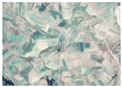 |
| 4 | Orchard | Granular texture and defined boundaries | 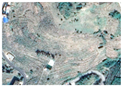 |
| 5 | Forest-grassland | Complex vegetation cover characteristics, various shapes, and indistinct boundaries | 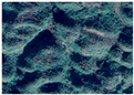 |
| 6 | Other | Bare land, wasteland, etc. | 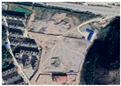 |
| Land Use Type | OA | Kappa | F1 | mIoU ± SD |
|---|---|---|---|---|
| Cropland | 0.918 | 0.831 | 0.901 | 0.819 ± 0.627 |
| Orchard | 0.981 | 0.917 | 0.927 | 0.864 ± 0.639 |
| Water | 0.992 | 0.929 | 0.933 | 0.874 ± 0.363 |
| Building | 0.985 | 0.758 | 0.765 | 0.620 ± 0.437 |
| Forest-grassland | 0.888 | 0.690 | 0.760 | 0.613 ± 0.531 |
| Other | 0.865 | 0.435 | 0.502 | 0.335 ± 0.836 |
| Overall | 0.815 | 0.750 | 0.798 | 0.688 ± 0.572 |
| Land Use Type | Area (km2) | PD | MPS (km2) | LSI |
|---|---|---|---|---|
| Cropland | 465.2 | 1580.29 | 0.00063 | 1.27 |
| Orchard | 105.6 | 188.15 | 0.00531 | 1.33 |
| Water | 4.3 | 222.09 | 0.00447 | 1.14 |
| Building | 30.3 | 4025.97 | 0.00025 | 1.09 |
| Forest-grassland | 1625.2 | 3.37 | 0.29646 | 4.32 |
| Mode | OA | Kappa | F1 | mIoU |
|---|---|---|---|---|
| Unified extraction by a single model | 0.787 | 0.675 | 0.745 | 0.603 |
| Stratified extraction by independent models | 0.815 | 0.750 | 0.798 | 0.688 |
Disclaimer/Publisher’s Note: The statements, opinions and data contained in all publications are solely those of the individual author(s) and contributor(s) and not of MDPI and/or the editor(s). MDPI and/or the editor(s) disclaim responsibility for any injury to people or property resulting from any ideas, methods, instructions or products referred to in the content. |
© 2025 by the authors. Licensee MDPI, Basel, Switzerland. This article is an open access article distributed under the terms and conditions of the Creative Commons Attribution (CC BY) license (https://creativecommons.org/licenses/by/4.0/).
Share and Cite
Li, B.; Zhou, Z.; Wu, T.; Luo, J. Fine-Grained Land Use Remote Sensing Mapping in Karst Mountain Areas Using Deep Learning with Geographical Zoning and Stratified Object Extraction. Remote Sens. 2025, 17, 2368. https://doi.org/10.3390/rs17142368
Li B, Zhou Z, Wu T, Luo J. Fine-Grained Land Use Remote Sensing Mapping in Karst Mountain Areas Using Deep Learning with Geographical Zoning and Stratified Object Extraction. Remote Sensing. 2025; 17(14):2368. https://doi.org/10.3390/rs17142368
Chicago/Turabian StyleLi, Bo, Zhongfa Zhou, Tianjun Wu, and Jiancheng Luo. 2025. "Fine-Grained Land Use Remote Sensing Mapping in Karst Mountain Areas Using Deep Learning with Geographical Zoning and Stratified Object Extraction" Remote Sensing 17, no. 14: 2368. https://doi.org/10.3390/rs17142368
APA StyleLi, B., Zhou, Z., Wu, T., & Luo, J. (2025). Fine-Grained Land Use Remote Sensing Mapping in Karst Mountain Areas Using Deep Learning with Geographical Zoning and Stratified Object Extraction. Remote Sensing, 17(14), 2368. https://doi.org/10.3390/rs17142368