
Estimation of Forest Aboveground Biomass Using Sentinel-1/2 Synergized with Extrapolated Parameters from LiDAR Data and Analysis of Its Ecological Driving Factors

 ,
,
Abstract
1. Introduction
- (1)
- Can the integration of Sentinel-1, Sentinel-2, and airborne LiDAR data achieve high-accuracy forest AGB prediction?
- (2)
- What are the effects of forest attributes such as forest origin (plantation/natural forest), stand age, and degree of species mixing on the spatial distribution and temporal accumulation patterns of forest AGB?
2. Study Area and Data
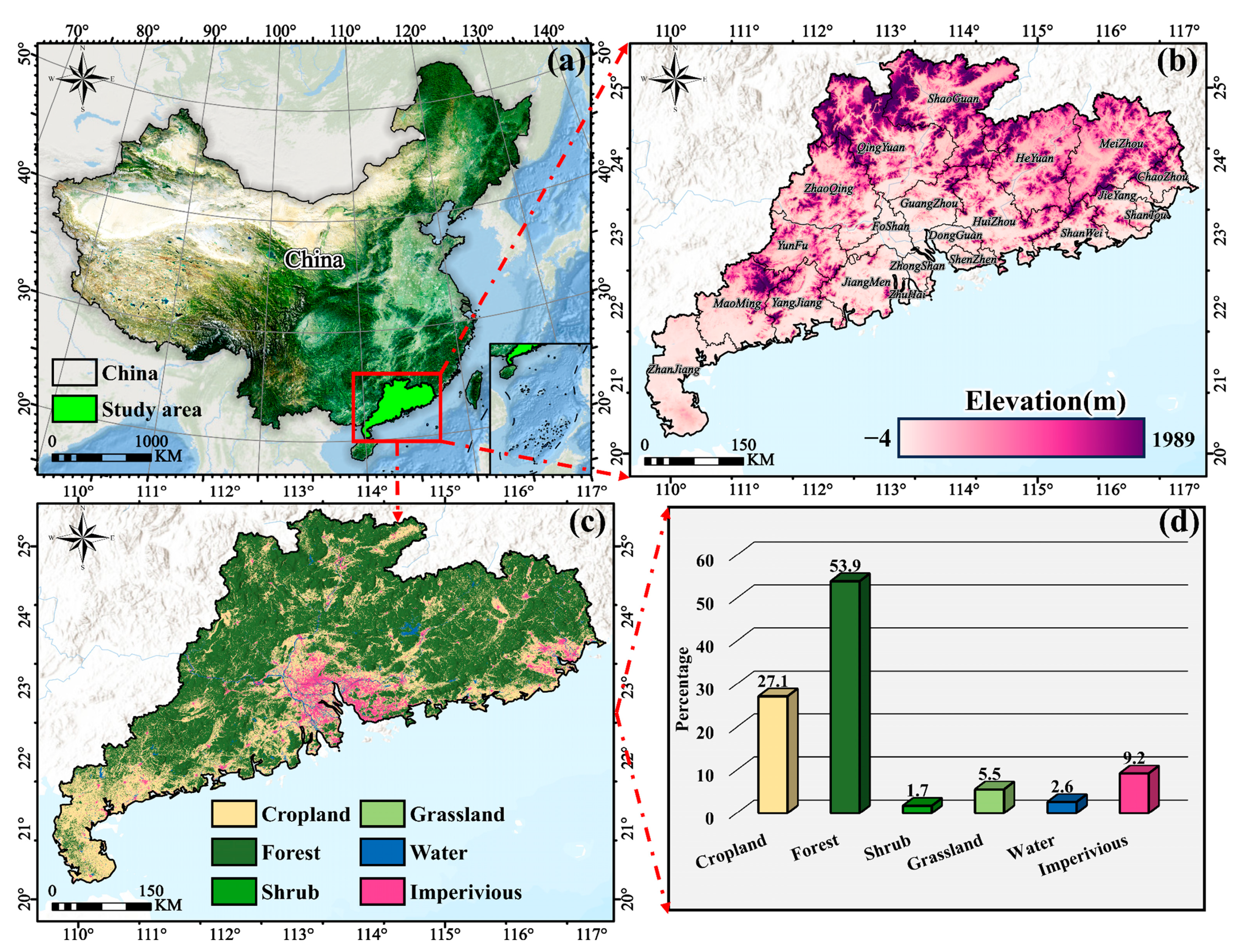
2.1. Study Area
2.2. Data
2.2.1. Sentinel-2 Data
2.2.2. Sentinel-1 Data
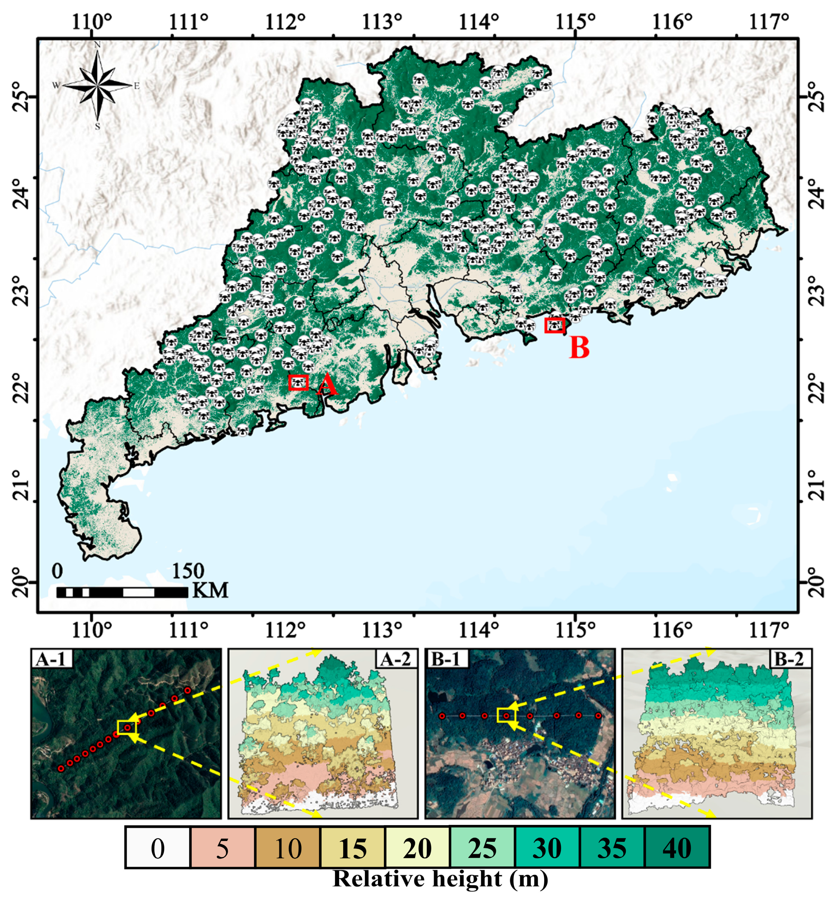
2.2.3. Laser Point Cloud Data
2.2.4. Forest Reference Data
3. Method
3.1. Extrapolation of Laser Point Cloud Derivative Parameters
3.2. Forest AGB Prediction
3.3. Forest Attribute Variable Acquisition
3.4. Validation of the Relationship Between Forest AGB and Forest Attribute Variables
4. Results
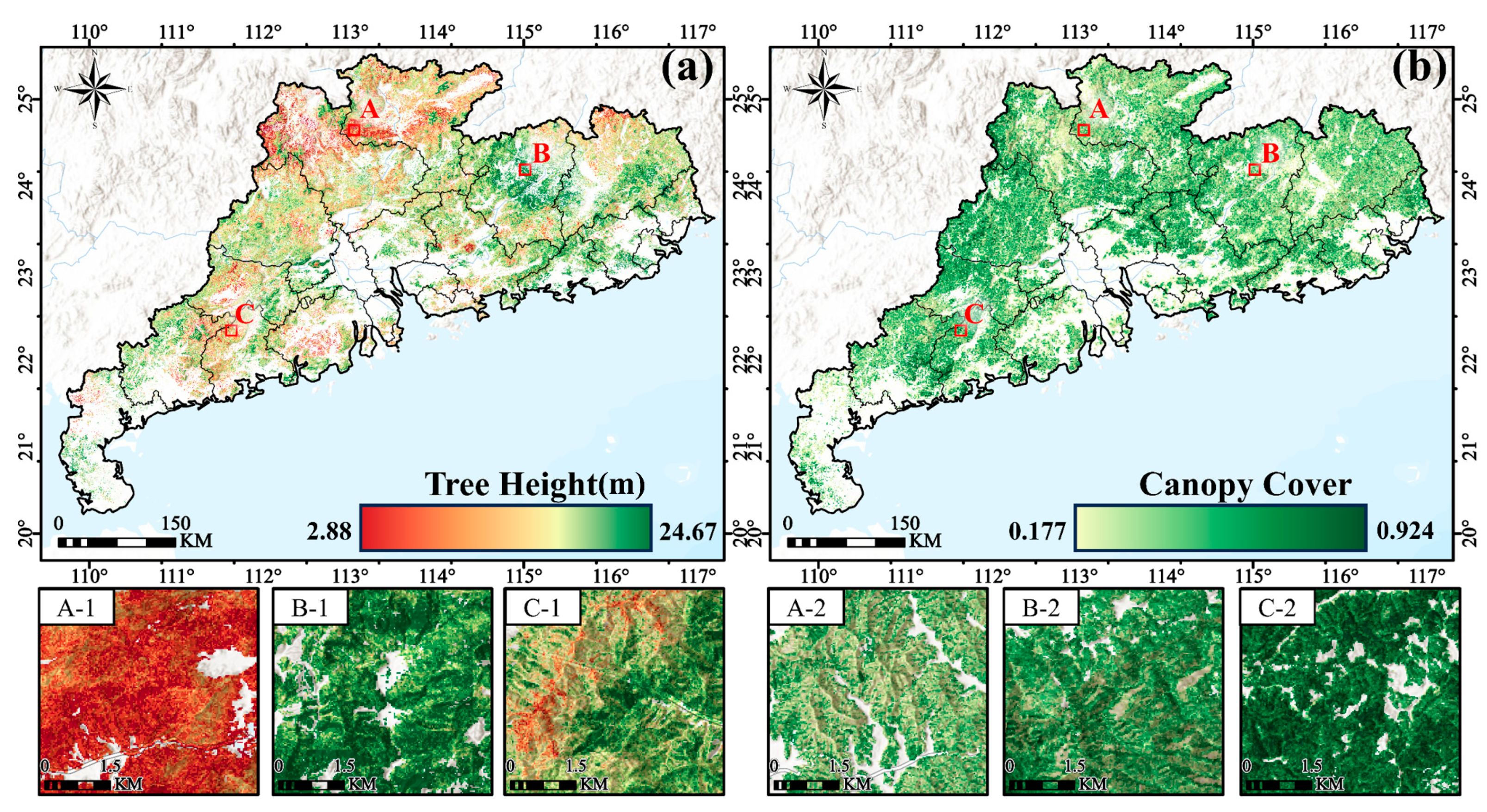
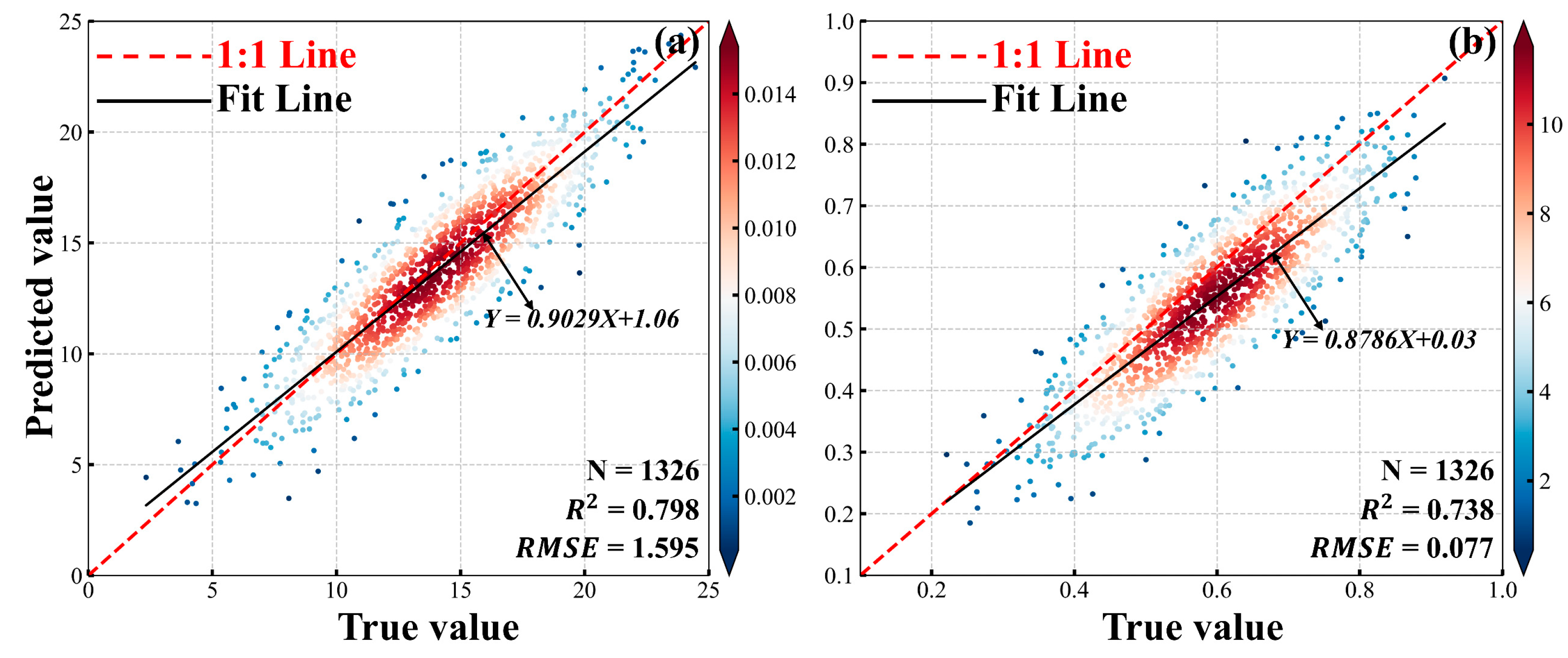
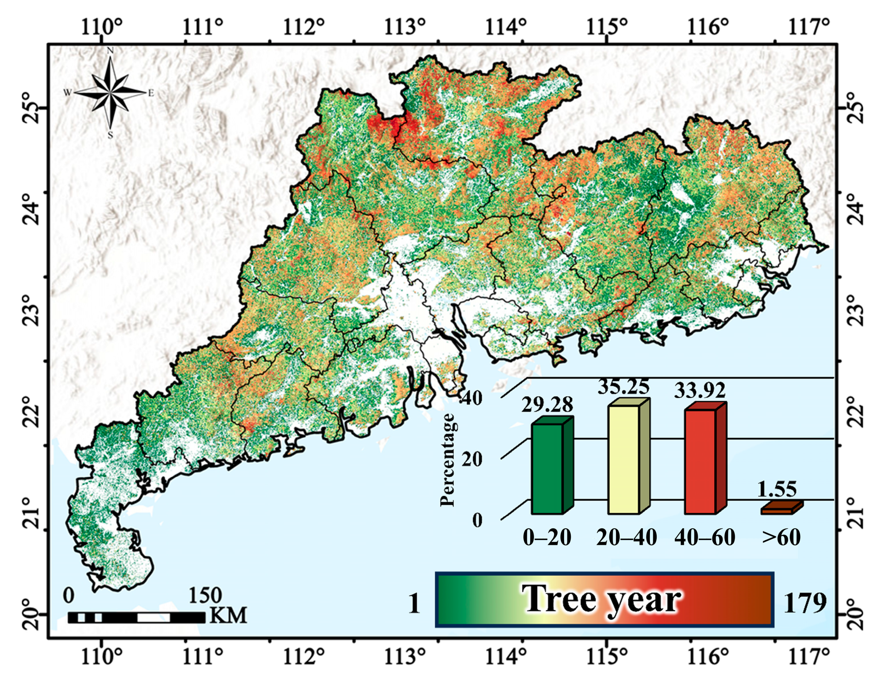
4.1. The Extrapolation Results of the Derived Parameters from the Laser Point Cloud
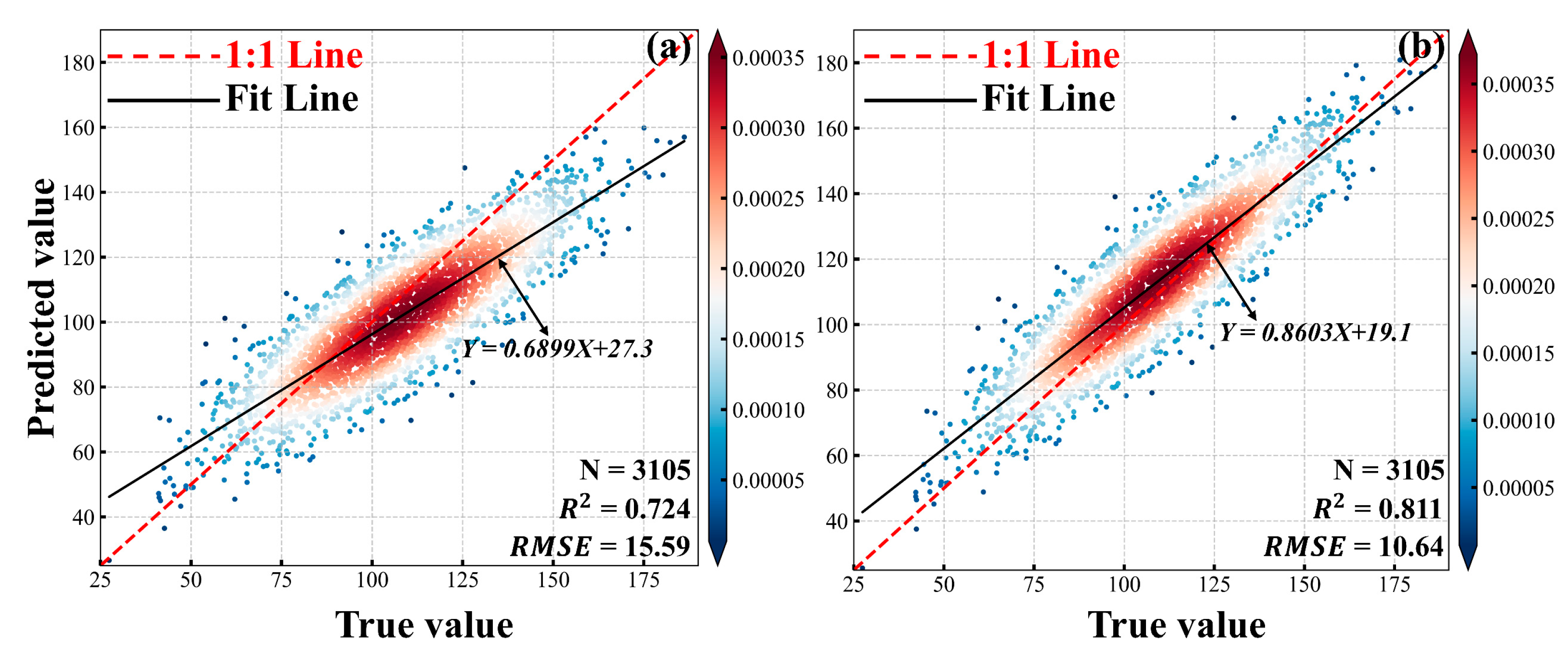
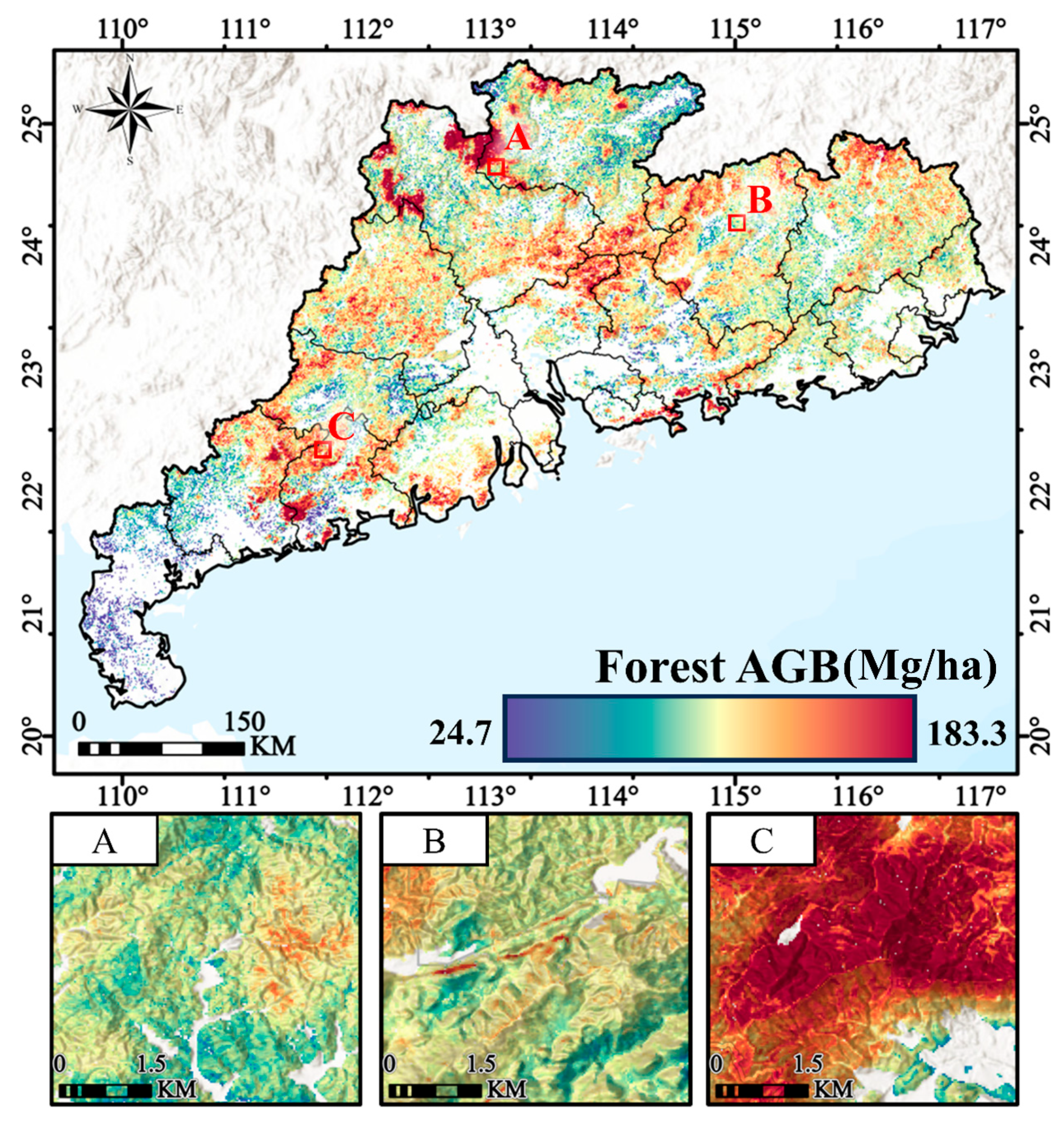
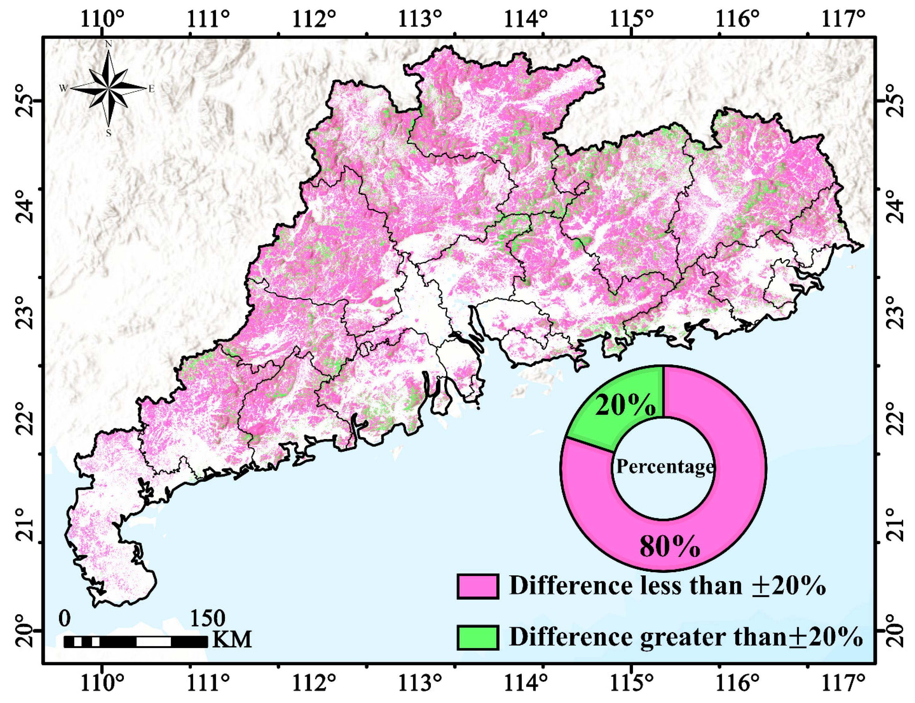
4.2. Forest AGB Prediction Results
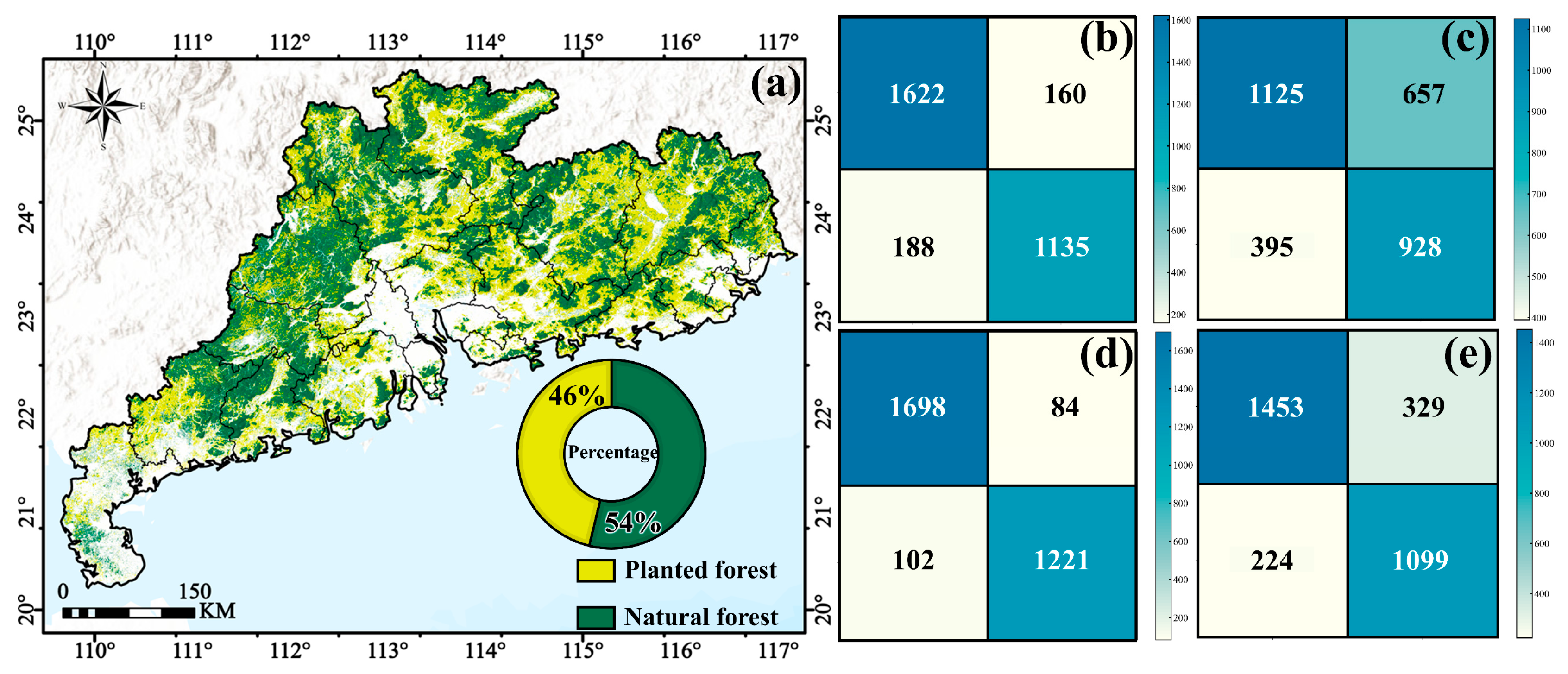
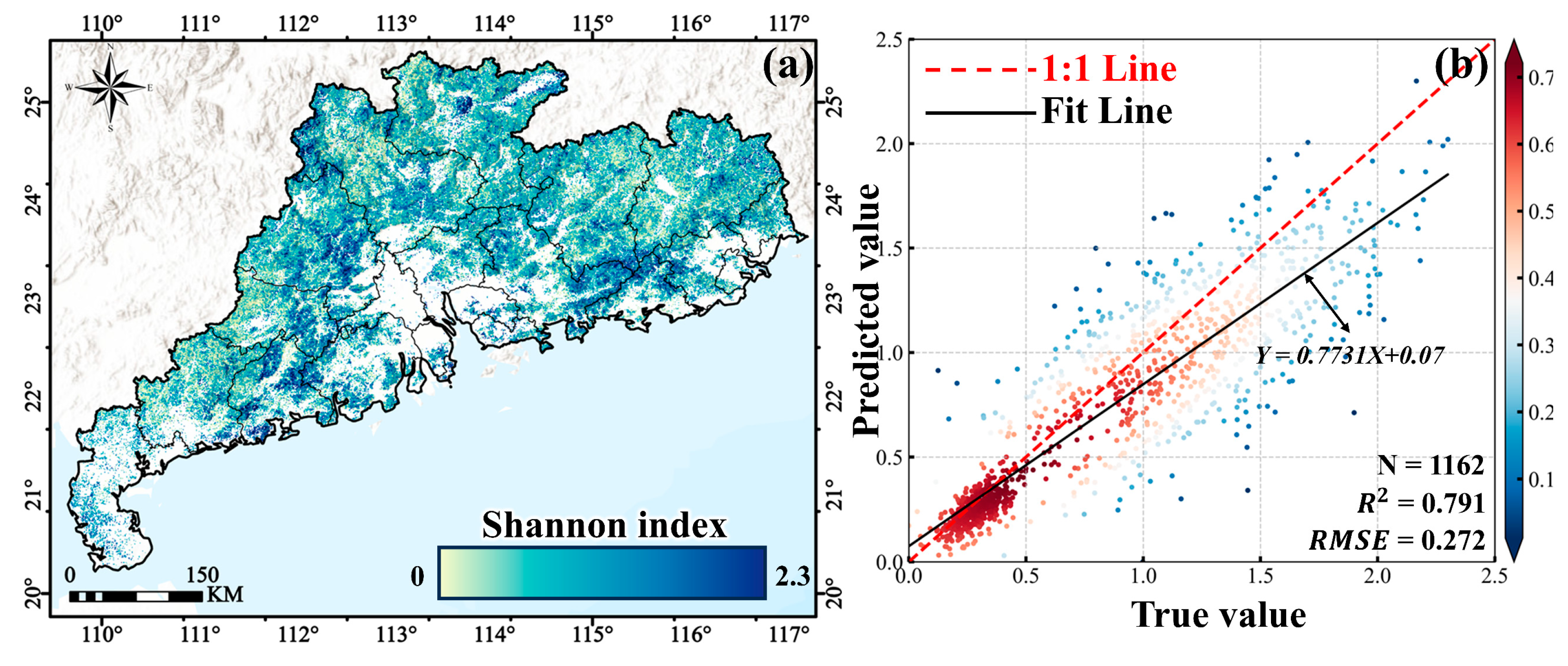
4.3. Prediction Results of Various Forest Attribute Variables
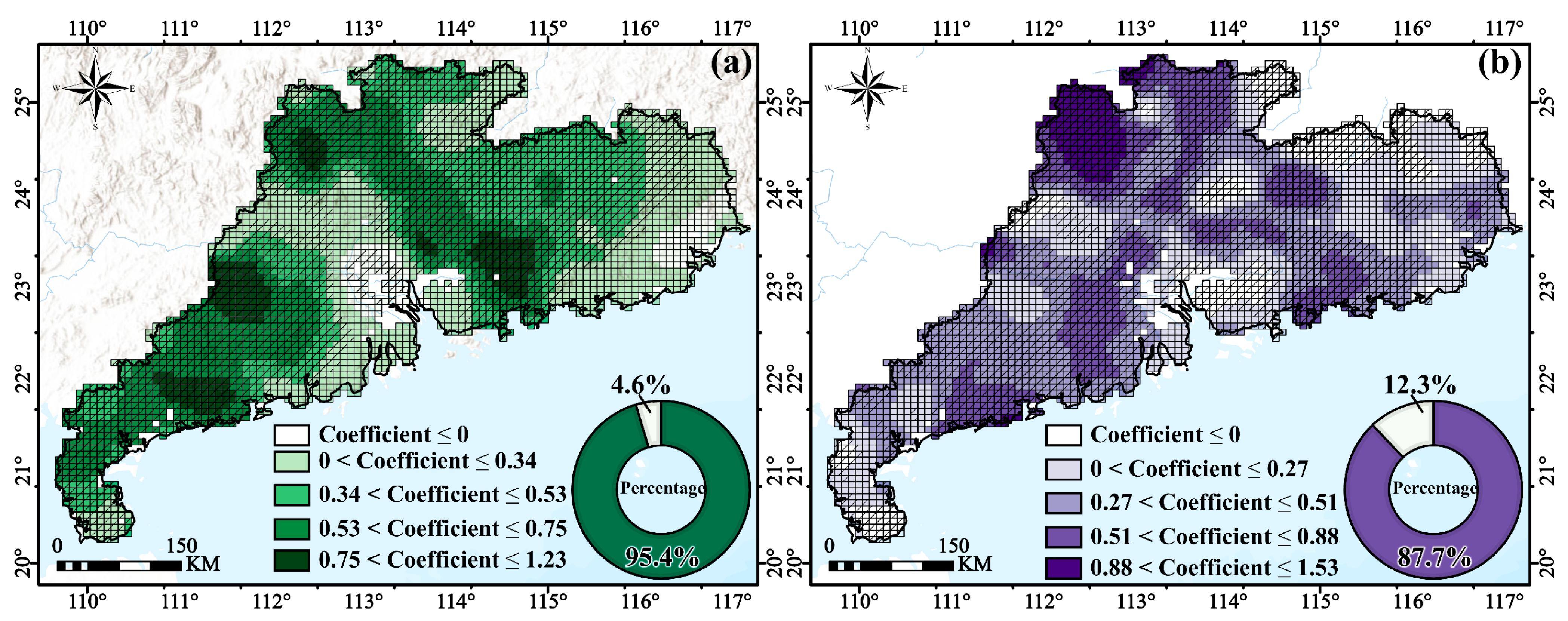
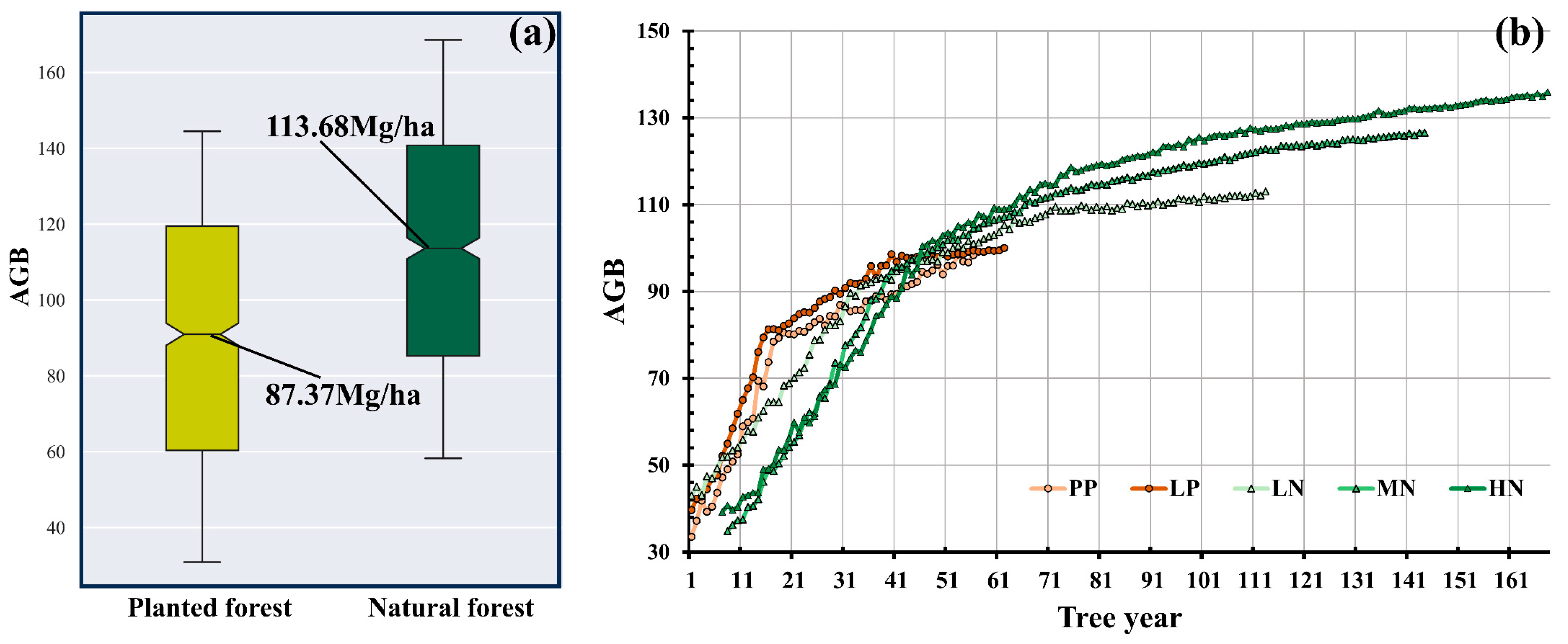
4.4. The Relationship Between Various Forest Variables and Forest AGB
5. Discussion
5.1. Uncertainty in the Elimination Process of Saturation Effects
5.2. Potential Constraints in the Construction of Forest Ecological Attribute Sets
5.3. Uncertainty About the Drivers of AGB Spatial Heterogeneity and Accumulation Patterns
6. Conclusions
Author Contributions
Funding
Data Availability Statement
Acknowledgments
Conflicts of Interest
References
- Piao, S.; Yue, H.; Wang, X.; Chen, F. Estimation of China’s terrestrial ecosystem carbon sink: Methods, progress and prospects. Sci. China Earth Sci. 2022, 65, 641–651. [Google Scholar] [CrossRef]
- Van der Werf, G.R.; Morton, D.C.; DeFries, R.S.; Olivier, J.G.; Kasibhatla, P.S.; Jackson, R.B.; Collatz, G.J.; Randerson, J.T. CO2 emissions from forest loss. Nat. Geosci. 2009, 2, 737–738. [Google Scholar]
- Pan, Y.; Birdsey, R.A.; Fang, J.; Houghton, R.; Kauppi, P.E.; Kurz, W.A.; Phillips, O.L.; Shvidenko, A.; Lewis, S.L.; Canadell, J.G. A large and persistent carbon sink in the world’s forests. Science 2011, 333, 988–993. [Google Scholar] [PubMed]
- Shendryk, Y. Fusing GEDI with earth observation data for large area aboveground biomass mapping. Int. J. Appl. Earth Obs. Geoinf. 2022, 115, 103108. [Google Scholar]
- Lu, D.; Chen, Q.; Wang, G.; Liu, L.; Li, G.; Moran, E. A survey of remote sensing-based aboveground biomass estimation methods in forest ecosystems. Int. J. Digit. Earth 2016, 9, 63–105. [Google Scholar]
- Torre-Tojal, L.; Bastarrika, A.; Boyano, A.; Lopez-Guede, J.M.; Grana, M. Above-ground biomass estimation from LiDAR data using random forest algorithms. J. Comput. Sci. 2022, 58, 101517. [Google Scholar]
- Powell, S.L.; Cohen, W.B.; Healey, S.P.; Kennedy, R.E.; Moisen, G.G.; Pierce, K.B.; Ohmann, J.L. Quantification of live aboveground forest biomass dynamics with Landsat time-series and field inventory data: A comparison of empirical modeling approaches. Remote Sens. Environ. 2010, 114, 1053–1068. [Google Scholar]
- Soenen, S.A.; Peddle, D.R.; Hall, R.J.; Coburn, C.A.; Hall, F.G. Estimating aboveground forest biomass from canopy reflectance model inversion in mountainous terrain. Remote Sens. Environ. 2010, 114, 1325–1337. [Google Scholar]
- Gizachew, B.; Solberg, S.; Næsset, E.; Gobakken, T.; Bollandsås, O.M.; Breidenbach, J.; Zahabu, E.; Mauya, E.W. Mapping and estimating the total living biomass and carbon in low-biomass woodlands using Landsat 8 CDR data. Carbon Balance Manag. 2016, 11, 13. [Google Scholar]
- Pasquarella, V.J.; Holden, C.E.; Woodcock, C.E. Improved mapping of forest type using spectral-temporal Landsat features. Remote Sens. Environ. 2018, 210, 193–207. [Google Scholar]
- Hościło, A.; Lewandowska, A. Mapping forest type and tree species on a regional scale using multi-temporal Sentinel-2 data. Remote Sens. 2019, 11, 929. [Google Scholar]
- Sibanda, M.; Mutanga, O.; Rouget, M. Discriminating rangeland management practices using simulated hyspIRI, landsat 8 OLI, sentinel 2 MSI, and VENµs spectral data. IEEE J. Sel. Top. Appl. Earth Obs. Remote Sens. 2016, 9, 3957–3969. [Google Scholar]
- Wan, L.; Ryu, Y.; Dechant, B.; Hwang, Y.; Feng, H.; Kang, Y.; Jeong, S.; Lee, J.; Choi, C.; Bae, J. Correcting confounding canopy structure, biochemistry and soil background effects improves leaf area index estimates across diverse ecosystems from Sentinel-2 imagery. Remote Sens. Environ. 2024, 309, 114224. [Google Scholar] [CrossRef]
- Mandl, L.; Viana-Soto, A.; Seidl, R.; Stritih, A.; Senf, C. Unmixing-based forest recovery indicators for predicting long-term recovery success. Remote Sens. Environ. 2024, 308, 114194. [Google Scholar] [CrossRef]
- Zeug, G.; Immitzer, M.; Neuwirth, M.; Atzberger, C. Machbarkeitsstudie zur Nutzung von Satellitenfernerkundungsdaten (Copernicus) für Zwecke der Ableitung Ökologischer Belastungsgrenzen und der Verifizierung von Indikatoren der Deutschen Anpassungsstrategie an den Klimawandel: Feasibility Study on the Use of Earth Observation Data for the Purpose of Determining Ecological Exposure Limits and for the Verification of Indicators of the German Adaptation Strategy to Climate Change; Terranea UG: Geltendorf, Germany, 2018. [Google Scholar]
- Majasalmi, T.; Rautiainen, M. The potential of Sentinel-2 data for estimating biophysical variables in a boreal forest: A simulation study. Remote Sens. Lett. 2016, 7, 427–436. [Google Scholar]
- Woodhouse, I.H.; Mitchard, E.T.A.; Brolly, M.; Maniatis, D.; Ryan, C.M. Radar backscatter is not a ‘direct measure’ of forest biomass. Nat. Clim. Change 2012, 2, 556–557. [Google Scholar]
- Mitchard, E.T.; Saatchi, S.S.; White, L.J.; Abernethy, K.A.; Jeffery, K.J.; Lewis, S.L.; Collins, M.; Lefsky, M.A.; Leal, M.E.; Woodhouse, I.H. Mapping tropical forest biomass with radar and spaceborne LiDAR in Lopé National Park, Gabon: Overcoming problems of high biomass and persistent cloud. Biogeosciences 2012, 9, 179–191. [Google Scholar]
- Su, Y.; Guo, Q.; Xue, B.; Hu, T.; Alvarez, O.; Tao, S.; Fang, J. Spatial distribution of forest aboveground biomass in China: Estimation through combination of spaceborne lidar, optical imagery, and forest inventory data. Remote Sens. Environ. 2016, 173, 187–199. [Google Scholar] [CrossRef]
- Zhao, P.; Lu, D.; Wang, G.; Wu, C.; Huang, Y.; Yu, S. Examining Spectral Reflectance Saturation in Landsat Imagery and Corresponding Solutions to Improve Forest Aboveground Biomass Estimation. Remote Sens. 2016, 8, 469. [Google Scholar]
- Minh, D.H.T.; Le Toan, T.; Rocca, F.; Tebaldini, S.; Villard, L.; Réjou-Méchain, M.; Phillips, O.L.; Feldpausch, T.R.; Dubois-Fernandez, P.; Scipal, K. SAR tomography for the retrieval of forest biomass and height: Cross-validation at two tropical forest sites in French Guiana. Remote Sens. Environ. 2016, 175, 138–147. [Google Scholar]
- Lucas, R.M.; Mitchell, A.L.; Armston, J. Measurement of forest above-ground biomass using active and passive remote sensing at large (subnational to global) scales. Curr. For. Rep. 2015, 1, 162–177. [Google Scholar]
- Popescu, S.C.; Zhao, K.; Neuenschwander, A.; Lin, C. Satellite lidar vs. small footprint airborne lidar: Comparing the accuracy of aboveground biomass estimates and forest structure metrics at footprint level. Remote Sens. Environ. 2011, 115, 2786–2797. [Google Scholar] [CrossRef]
- May, P.B.; Schlund, M.; Armston, J.; Kotowska, M.M.; Brambach, F.; Wenzel, A.; Erasmi, S. Mapping aboveground biomass in Indonesian lowland forests using GEDI and hierarchical models. Remote Sens. Environ. 2024, 313, 114384. [Google Scholar] [CrossRef]
- Xi, Y.; Tian, Q.; Zhang, W.; Zhang, Z.; Tong, X.; Brandt, M.; Fensholt, R. Quantifying understory vegetation density using multi-temporal Sentinel-2 and GEDI LiDAR data. GISci. Remote Sens. 2022, 59, 2068–2083. [Google Scholar]
- Qiuyue, F.; shan, Z.; Su, H.; Chongyu, Y.; Dongming, F.; Tingting, M.; Guomo, Z. Above-ground biomass of Moso bamboo forests in China influenced by climate, soil and topography: A meta-analysis. Adv. Bamboo Sci. 2024, 8, 100091. [Google Scholar] [CrossRef]
- Xu, M.; Ji, H.; Zhuang, S. Carbon stock of Moso bamboo (Phyllostachys pubescens) forests along a latitude gradient in the subtropical region of China. PLoS ONE 2018, 13, e0193024. [Google Scholar]
- Bai, J.; Ren, C.; Shi, X.; Xiang, H.; Zhang, W.; Jiang, H.; Ren, Y.; Xi, Y.; Wang, Z.; Mao, D. Tree species diversity impacts on ecosystem services of temperate forests. Ecol. Indic. 2024, 167, 112639. [Google Scholar] [CrossRef]
- Laclau, J.-P.; Ranger, J.; de Moraes Gonçalves, J.L.; Maquère, V.; Krusche, A.V.; M’Bou, A.T.; Nouvellon, Y.; Saint-André, L.; Bouillet, J.-P.; de Cassia Piccolo, M. Biogeochemical cycles of nutrients in tropical Eucalyptus plantations: Main features shown by intensive monitoring in Congo and Brazil. For. Ecol. Manag. 2010, 259, 1771–1785. [Google Scholar]
- Felipe-Lucia, M.R.; Soliveres, S.; Penone, C.; Manning, P.; van der Plas, F.; Boch, S.; Prati, D.; Ammer, C.; Schall, P.; Gossner, M.M. Multiple forest attributes underpin the supply of multiple ecosystem services. Nat. Commun. 2018, 9, 4839. [Google Scholar]
- Indirabai, I.; Nilsson, M. Estimation of above ground biomass in tropical heterogeneous forests in India using GEDI. Ecol. Inform. 2024, 82, 102712. [Google Scholar] [CrossRef]
- Sun, H.; Terhonen, E.; Koskinen, K.; Paulin, L.; Kasanen, R.; Asiegbu, F.O. Bacterial diversity and community structure along different peat soils in boreal forest. Appl. Soil Ecol. 2014, 74, 37–45. [Google Scholar]
- Qu, Z.; Liu, B.; Ma, Y.; Sun, H. Differences in bacterial community structure and potential functions among Eucalyptus plantations with different ages and species of trees. Appl. Soil Ecol. 2020, 149, 103515. [Google Scholar] [CrossRef]
- Tucker, C.J. Red and photographic infrared linear combinations for monitoring vegetation. Remote Sens. Environ. 1979, 8, 127–150. [Google Scholar] [CrossRef]
- Bolyn, C.; Michez, A.; Gaucher, P.; Lejeune, P.; Bonnet, S. Forest mapping and species composition using supervised per pixel classification of Sentinel-2 imagery. Biotechnol. Agron. Soc. Environ. 2018, 22, 172–187. [Google Scholar]
- Jordan, C.F. Derivation of Leaf-Area Index from Quality of Light on the Forest Floor. Ecology 1969, 50, 663–666. [Google Scholar] [CrossRef]
- Badgley, G.; Field, C.B.; Berry, J.A. Canopy near-infrared reflectance and terrestrial photosynthesis. Sci. Adv. 2017, 3, e1602244. [Google Scholar] [CrossRef]
- Martimort, P.; Fernandez, V.; Kirschner, V.; Isola, C.; Meygret, A. Sentinel-2 MultiSpectral imager (MSI) and calibration/validation. In Proceedings of the 2012 IEEE International Geoscience and Remote Sensing Symposium, Munich, Germany, 22–27 July 2012; pp. 6999–7002. [Google Scholar]
- Huete, A.; Didan, K.; Miura, T.; Rodriguez, E.P.; Gao, X.; Ferreira, L.G. Overview of the radiometric and biophysical performance of the MODIS vegetation indices. Remote Sens. Environ. 2002, 83, 195–213. [Google Scholar] [CrossRef]
- Qi, Y.; Coops, N.C.; Daniels, L.D.; Butson, C.R. Comparing tree attributes derived from quantitative structure models based on drone and mobile laser scanning point clouds across varying canopy cover conditions. ISPRS J. Photogramm. Remote Sens. 2022, 192, 49–65. [Google Scholar] [CrossRef]
- Yang, Q.; Niu, C.; Liu, X.; Feng, Y.; Ma, Q.; Wang, X.; Tang, H.; Guo, Q. Mapping high-resolution forest aboveground biomass of China using multisource remote sensing data. GISci. Remote Sens. 2023, 60, 2203303. [Google Scholar]
- Shang, R.; Lin, X.; Chen, J.M.; Liang, Y.; Fang, K.; Xu, M.; Yan, Y.; Ju, W.; Yu, G.; He, N.; et al. China’s annual forest age dataset at 30 m spatial resolution from 1986 to 2022. Earth Syst. Sci. Data Discuss. 2025, 2025, 1–31. [Google Scholar] [CrossRef]
- Shang, R.; Chen, J.M.; Xu, M.; Lin, X.; Li, P.; Yu, G.; He, N.; Xu, L.; Gong, P.; Liu, L.; et al. China’s current forest age structure will lead to weakened carbon sinks in the near future. Innovation 2023, 4, 100515. [Google Scholar] [CrossRef] [PubMed]
- Zolkos, S.G.; Goetz, S.J.; Dubayah, R. A meta-analysis of terrestrial aboveground biomass estimation using lidar remote sensing. Remote Sens. Environ. 2013, 128, 289–298. [Google Scholar] [CrossRef]
- Liu, L.; Zeng, F.; Song, T.; Wang, K.; Du, H. Stand structure and abiotic factors modulate karst forest biomass in Southwest China. Forests 2020, 11, 443. [Google Scholar] [CrossRef]
- Liu, L.; Chang, S.X.; Huang, C.; Zhi, Y.; Jie, Y.; Yu, X.; Jiang, P. Enhancement of phytolith-occluded carbon accumulation of Moso bamboo response to temperatures elevation and different fertilization. Front. Plant Sci. 2023, 14, 1144961. [Google Scholar]
- Waite, O.J.M.; Coops, N.C.; Grubinger, S.; Isaac-Renton, M.; Degner, J.; King, J.; Liu, A. Responses of spectral indices to heat and drought differ by tree size in Douglas-fir. Sci. Remote Sens. 2025, 11, 100193. [Google Scholar] [CrossRef]
- Marias, D.E.; Meinzer, F.C.; Woodruff, D.R.; McCulloh, K.A. Thermotolerance and heat stress responses of Douglas-fir and ponderosa pine seedling populations from contrasting climates. Tree Physiol. 2017, 37, 301–315. [Google Scholar]
- Wang, S.; Zuo, X.; Zhao, X.; Awada, T.; Luo, Y.; Li, Y.; Qu, H. Dominant plant species shape soil bacterial community in semiarid sandy land of northern China. Ecol. Evol. 2018, 8, 1693–1704. [Google Scholar]
- Rodrigues, A.C.; Villa, P.M.; Ferreira-Júnior, W.G.; Schaefer, C.E.R.G.; Neri, A.V. Effects of topographic variability and forest attributes on fine-scale soil fertility in late-secondary succession of Atlantic Forest. Ecol. Process. 2021, 10, 62. [Google Scholar] [CrossRef]

| Spectral Indices | Description | Formula |
|---|---|---|
| NDVI [34] | Normalized Difference Vegetation Index | (B8 − B4)/(B8 + B4) |
| SAVI [35] | Soil-Adjusted Vegetation Index | (1 + 0.2) × float (B8 − B4)/(B8 + B4 + 0.2) |
| RVI [36] | Ratio Vegetation Index | B4/B8 |
| NIRV [37] | Near-Infrared Reflection of Vegetation | |
| REIP [38] | Red-Edge Inflection Point Index | ((B4 + B7)/2 − (B5/B6) − B5) |
| EVI [39] | Enhanced Vegetation Index | 2.5 × (B8 − B4)/(B8 + 6 × B4 − 7.5 × B2 + 1) |
| Model | OA | Kappa Coefficient |
|---|---|---|
| RF | 89% | 0.77 |
| SVM | 79% | 0.57 |
| XGB | 93% | 0.85 |
| MLC | 82% | 0.64 |
Disclaimer/Publisher’s Note: The statements, opinions and data contained in all publications are solely those of the individual author(s) and contributor(s) and not of MDPI and/or the editor(s). MDPI and/or the editor(s) disclaim responsibility for any injury to people or property resulting from any ideas, methods, instructions or products referred to in the content. |
© 2025 by the authors. Licensee MDPI, Basel, Switzerland. This article is an open access article distributed under the terms and conditions of the Creative Commons Attribution (CC BY) license (https://creativecommons.org/licenses/by/4.0/).
Share and Cite
Xu, X.; Yang, J.; Qi, S.; Ma, Y.; Liu, W.; Li, L.; Lu, X.; Liu, Y. Estimation of Forest Aboveground Biomass Using Sentinel-1/2 Synergized with Extrapolated Parameters from LiDAR Data and Analysis of Its Ecological Driving Factors. Remote Sens. 2025, 17, 2358. https://doi.org/10.3390/rs17142358
Xu X, Yang J, Qi S, Ma Y, Liu W, Li L, Lu X, Liu Y. Estimation of Forest Aboveground Biomass Using Sentinel-1/2 Synergized with Extrapolated Parameters from LiDAR Data and Analysis of Its Ecological Driving Factors. Remote Sensing. 2025; 17(14):2358. https://doi.org/10.3390/rs17142358
Chicago/Turabian StyleXu, Xu, Jingyu Yang, Shanze Qi, Yue Ma, Wei Liu, Luanxin Li, Xiaoqiang Lu, and Yan Liu. 2025. "Estimation of Forest Aboveground Biomass Using Sentinel-1/2 Synergized with Extrapolated Parameters from LiDAR Data and Analysis of Its Ecological Driving Factors" Remote Sensing 17, no. 14: 2358. https://doi.org/10.3390/rs17142358
APA StyleXu, X., Yang, J., Qi, S., Ma, Y., Liu, W., Li, L., Lu, X., & Liu, Y. (2025). Estimation of Forest Aboveground Biomass Using Sentinel-1/2 Synergized with Extrapolated Parameters from LiDAR Data and Analysis of Its Ecological Driving Factors. Remote Sensing, 17(14), 2358. https://doi.org/10.3390/rs17142358