Article

Theoretical Potential of TanSat-2 to Quantify China’s CH4 Emissions

1
Carbon Neutrality Research Center, Institute of Atmospheric Physics, Chinese Academy of Sciences, Beijing 100029, China
2
University of Chinese Academy of Sciences, Beijing 100049, China
3
School of GeoSciences, University of Edinburgh, Edinburgh EH9 3FF, UK
4
National Centre for Earth Observation, University of Edinburgh, Edinburgh EH9 3FF, UK
5
Innovation Academy for Microsatellites, Chinese Academy of Sciences, Shanghai 201306, China
6
State Key Laboratory of Atmospheric Environment and Extreme Meteorology, Institute of Atmospheric Physics, Chinese Academy of Sciences, Beijing 100029, China
*
Author to whom correspondence should be addressed.
Remote Sens. 2025, 17(13), 2321; https://doi.org/10.3390/rs17132321
Submission received: 2 May 2025 / Revised: 21 June 2025 / Accepted: 1 July 2025 / Published: 7 July 2025

Abstract

Satellite-based monitoring of atmospheric column-averaged dry-air mole fraction (XCH4) is essential for quantifying methane (CH4) emissions, yet uncharacterized spatially varying biases in XCH4 observations can cause misattribution in flux estimates. This study assesses the potential of the upcoming TanSat-2 satellite mission to estimate China’s CH4 emission using a series of Observing System Simulation Experiments (OSSEs) based on an Ensemble Kalman Filter (EnKF) inversion framework coupled with GEOS-Chem on a 0.5° × 0.625° grid, alongside an evaluation of current TROPOMI-based products against Total Carbon Column Observing Network (TCCON) observations. Assuming a target precision of 8 ppb, TanSat-2 could achieve an annual national emission estimate accuracy of 2.9% ± 4.2%, reducing prior uncertainty by 84%, with regional deviations below 5.0% across Northeast, Central, East, and Southwest China. In contrast, limited coverage in South China due to persistent cloud cover leads to a 26.1% discrepancy—also evident in pseudo TROPOMI OSSEs—highlighting the need for complementary ground-based monitoring strategies. Sensitivity analyses show that satellite retrieval biases strongly affect inversion robustness, reducing the accuracy in China’s total emission estimates by 5.8% for every 1 ppb increase in bias level across scenarios, particularly in Northeast, Central and East China. We recommend expanding ground-based XCH4 observations in these regions to support the correction of satellite-derived biases and improve the reliability of satellite-constrained inversion results.

1. Introduction

Atmospheric methane (CH4) is the most important greenhouse gas after carbon dioxide (CO2), with current concentrations reaching 265% of pre-industrial levels [1]. It has contributed approximately 0.5 °C to global warming since the pre-industrial era [2]. The substantial global warming potential (~80 times that of CO2 over a 20-year period on a molar basis) and comparatively short atmospheric lifetime (~10 years) make CH4 mitigation a key strategy for achieving the Paris Agreement’s 1.5 °C target [3,4]. Atmospheric inversion methods that assimilate satellite-derived column-averaged dry-air mole fraction (XCH4) observations are increasingly essential for quantifying emissions and monitoring mitigation progress, owing to their improved temporal resolution and broad spatial coverage [5,6].
Global CH4 monitoring has advanced significantly with the deployment of satellite instruments such as GOSAT (2009–present; 10 km circular pixels separated by ~270 km), which supports long-term trend analysis [7,8,9,10,11], and TROPOMI (2018–present; 5.5 × 7 km2 pixel size), which enables finer-scale detection of emission sources [12,13,14,15]. However, systematic errors in the XCH4 retrievals, particularly spatially varying biases, remain a key challenge [16,17]. These biases can propagate through atmospheric inversion processes and significantly affect the accuracy of regional CH4 flux estimates. Even small retrieval biases have been shown to significantly impact regional flux inversion accuracy [18,19]. In China, such biases may be an important cause of the discrepancies in estimated methane emissions, with reported magnitudes ranging from 52 to 65 Tg CH4 yr−1 and trends between 0.36 and 0.73 Tg CH4 yr−2 during the 2010s [11,14,20,21,22,23].
Previous global evaluations using TCCON (Total Carbon Column Observing Network) ground-based measurements [24] have shown that GOSAT full-physics XCH4 products exhibit station-to-station biases of 2.7–6.0 ppb [25,26], while the proxy method yields biases below 4 ppb [18,27]. TROPOMI biases were initially ~9.5 ppb due to surface albedo effects [28], although corrections have reduced these to 4.4–6.7 ppb [28,29,30]. However, the performance of these products over Asia—where surface and atmospheric conditions vary widely—remains insufficiently assessed. Therefore, the first objective of this study is to evaluate four widely used GOSAT and TROPOMI XCH4 products against TCCON observations across Asia.
China’s second-generation greenhouse gas satellite, TanSat-2, is scheduled for launch in 2026 into a medium Earth orbit (MEO). It configures with a swath width of 1500 km and a pixel size of 2 × 2 km2, targeting a high precision of 8 ppb (including both systematically bias and random errors) for XCH4 measurements. Here, we developed several hypothetical XCH4 bias scenarios following Zhu et al. (2025) [31]. Using an established ensemble Kalman filter (EnKF) inversion framework coupled with GEOS-Chem chemistry and transport model, we performed a series of Observing System Simulation Experiments (OSSEs) on a 0.5° × 0.625° (latitude × longitude) grid. These experiments assess the theoretical potential of TanSat-2 to constrain CH4 emission estimates for China.

2. Materials and Methods

2.1. Assessment of XCH4 Products

Table 1 summarizes four XCH4 products, including (1) version 9.0 University of Leicester GOSAT proxy retrieval (OCPR), as published and updated by Parker et al. (2020) [27]; (2) version 14_449 TROPOMI operational retrieval from the Netherlands Institute for Space Research (SRON), utilizing the RemoTec full-physics algorithm [28]; (3) version 1.8 the TROPOMI methane retrieval from the University of Bremen, based on the Weighting Function Modified Differential Optical Absorption Spectroscopy (WFMD) algorithm [29]; and (4) a blended TROPOMI+GOSAT dataset, developed through the application of a machine learning model (LightGBM) [30].
GOSAT measures the atmospheric absorption of backscattered solar radiation in the 1.65 μm spectral band with a spectral resolution of 0.06 nm, enabling accurate retrieval of XCH4 through the proxy approach, which exploits concurrent CO2 absorption within the same band. This technique effectively mitigates retrieval biases associated with surface reflectivity and atmospheric aerosols. The latest GOSAT proxy XCH4 retrievals demonstrate a variable bias of only 3.9 ppb when referenced to TCCON data [27]. This bias is further reduced to 2.9 ppb through the application of unified averaging kernels and consistent prior vertical profiles, confirming it as a high-quality XCH4 product [18]. TROPOMI provides global daily coverage with a data density exceeding that of GOSAT by more than two orders of magnitude. Operating in the 2.3 μm spectral band, TROPOMI does not support the proxy retrieval approach; instead, it employs a full-physics method at a spectral resolution of 0.25 nm. While this approach enables detailed characterization of methane, it is more susceptible to scattering-related artifacts, particularly over regions with low shortwave infrared (SWIR) surface albedo [12,32,33]. Nevertheless, methodological advancements have led to significant improvements in retrieval accuracy, with spatially variable bias reduced to 5.1, 5.2 and 4.4 ppb across three TROPOMI XCH4 products, as summarized in Table 1.
Figure 1a–d depicts the XCH4 distribution from GOSAT OCPR, TROPOMI SRON, TROPOMI WFMD and Blended TROPOMI+GOSAT products over Eastern and Southern Asia (ES Asia, longitude: 60°E–90°E; latitude: 10°S–55°N), averaged from June 2018 to May 2021. All four datasets consistently show elevated XCH4 concentrations over Central and South China, the North Indian Plain, and Bangladesh, with lower concentrations over the Qinghai–Tibet Plateau and equatorial land regions. Compared to the GOSAT proxy dataset, the TROPOMI retrievals provide denser spatial coverage. However, substantial discrepancies exist among the three TROPOMI-based products in terms of both spatial coverage and mean XCH4 concentrations. The TROPOMI SRON product shows sparse observations in the northern Qinghai–Tibet Plateau and Xinjiang province, in contrast to the TROPOMI WFMD and the blended TROPOMI+GOSAT datasets. Additionally, the WFMD and blended products differ in their mean spatial distributions, particularly over the northern Qinghai–Tibet Plateau and the Sichuan Basin. These discrepancies are driven by both XCH4 retrieval biases and seasonal variations in data availability (Figure 1g,h).
Figure 1e–h present the seasonal distribution of XCH4 retrieval counts across major regions of China. The GOSAT proxy product yields an average of 18,362 observations per year over China, spread unevenly throughout the year. North China accounts for 12% of the total observations—2 to 4 times higher than other regions excluding the Northwest (Figure 1e). In contrast, South China records the fewest observations (~540 annually), primarily due to interference from water vapor and cloud cover. This limitation is particularly evident in spring and summer, when monthly observations fall below 35. TROPOMI-based XCH4 products provide 1 to 2 orders of magnitude more observations over China, ranging from 0.5 to 6.9 million per year, with the TROPOMI WFMD product offering the highest data density (Figure 1g). However, these observations are unevenly distributed geographically, with 77% located in Northwest China and less than 1% in southern regions (Southwest and South China), despite substantial methane emissions from rice paddies and waste in those areas [14]. Despite this imbalance, observation counts in southern regions remain 1.4 times higher than those from the TROPOMI SRON product, which predominantly samples Northeast China—a spatial pattern distinct from the other retrievals (Figure 1f).
Overall, the spatial distribution of XCH4 observations shows an inverse relationship with distribution of methane emission. The highest sampling densities are found in Northwest China, a region with relatively low methane emissions, while the southeastern regions—where emissions are highest—receive significantly fewer observations. Additionally, the temporal distribution of observations is seasonally skewed, with greater data availability during the colder months and reduced coverage in warmer seasons (Figure 1e–h). This seasonal sampling pattern is misaligned with China’s methane emission cycle, which typically peaks during the warmer months.
We resampled four XCH4 products onto a 0.5° × 0.625° (latitude × longitude) grid and selected consistent locations across all products for comparison. Relative to the GOSAT proxy dataset, the mean XCH4 discrepancies for the TROPOMI SRON, TROPOMI WFMD, and blended TROPOMI+GOSAT products are −7.3 ± 16.7 ppb, −2.9 ± 15.9 ppb, and −11.6 ± 13.7 ppb, respectively, based on co-located observations from all four datasets. To further assess the performance of these satellite retrievals, we compared them with ground-based XCH4 measurements from six Asian stations of TCCON [34,35,36,37,38,39]. Table 2 summarizes the validation results with scatter plots shown in Figure S1. The corresponding mean biases are 9.1 ppb for GOSAT OCPR, 7.2 ppb for TROPOMI SRON, 5.8 ppb for TROPOMI WFMD, and −3.0 ppb for the blended TROPOMI+GOSAT product.
Notably, TROPOMI SRON exhibits a higher spatially variable bias over ES Asia (8.9 ppb) compared to its global performance, whereas GOSAT OCPR, TROPOMI WFMD, and the blended TROPOMI+GOSAT product show lower variable biases of 3.3 ppb, 2.1 ppb, and 3.6 ppb, respectively (Table 1 and Table 2). Among these, TROPOMI WFMD demonstrates the lowest variability in station-to-station bias and the highest data availability, indicating it is the most suitable dataset for high-resolution methane inversion studies across ES Asia.

2.2. Pseudo Satellite XCH4 Observations

2.2.1. TanSat-2 Mission and Pseudo XCH4 Observations

The TanSat-2 mission, successor to the first TanSat [40,41,42,43,44,45,46,47], will operate in a medium Earth orbit (MEO) with an apogee of 7840 km, a perigee of 522 km, and a 1500 km across-track swath, achieving a 2 km × 2 km pixel resolution. Equipped with a hyperspectral grating spectrometer, TanSat-2 will cover multiple spectral bands, including the O2-A band (0.747–0.777 μm), O2-B band (0.672–0.702 μm), the CO2 weak band (1.590–1.620 μm), the CH4 band (1.63–1.67 μm), the CO2 strong band (1.990–2.095 μm), and an ultraviolet–visible band (0.4–0.5 μm) for NO2 measurements. Additionally, the mission will feature a new Cloud and Aerosol Polarization Imager (CAPI) to reduce uncertainties from aerosol and cloud interference. The precision benchmarks for CO2 and CH4 are established at 1 ppm and 8 ppb, respectively [48].
Errors in satellite retrievals can be classified into systematic and random components. Systematic errors ( μ ) primarily stem from calibration-related biases, including spectral drift and sensor degradation [49], as well as atmospheric interference effects. Key sources of atmospheric interference involve misinterpretation of surface albedo spectral characteristics, inaccurate characterization of clouds and aerosols, and stray light contamination from adjacent reflective surfaces [50,51]. Random noise (σ) in satellite XCH4 retrievals arises from various stochastic factors, such as intrinsic instrument noise, environmental variability, signal interference, and processing-related uncertainties [52,53,54].
In this work, the systematic errors component μ was parameterized as a function of the total aerosol and cloud optical depth (τ), using data from the MERRA-2 v5.12.4 dataset (M2T1NXAER and M2T3NVCLD). Following the method of Zhu et al. (2025) [31], a linear relationship was defined as μ = α ∙ (20 ∙ τ), where α is a scaling coefficient and μ is expressed in ppb. The σ was estimated based on measurement geometry and surface albedo, using the MERRA-2 M2TUNXRAD product. A nadir-view baseline of 8 ppb was assumed, with σ increasing by 2 ppb under solar zenith angles ranging from 0° to 70°. To align with real satellite data constraints, all OSSEs employed an AOD@550 nm threshold of <0.5 across land and ocean pseudo scenes.
To simulate realistic pseudo-observed XCH4 ( y o b s ) under the orbital configuration of TanSat-2 (Figure 2a), random perturbations ( y ~   N μ , σ 2 ) were applied to the “true” flux-derived XCH4 values ( y t r u e ). Following Zhu et al. (2025) [31], we adopted globally representative systematic and random error parameters, with μ = 1.3 ± 1.0 ppb and σ = 6.9 ± 1.6 ppb. These values were applied to generate pseudo XCH4 observations ( y o b s ), which define the baseline scenario for the control inversion test, hereafter referred to as INV_CTL.
y o b s = y t r u e + y = y t r u e + R a n d   1 2 π   σ e x p ( Y μ 2 2 σ 2 )
The probability distributions of μ , σ , and y under pseudo on-orbit over ES Asia on 1 July 2017 are presented in Figure 2, with spatial distribution for μ depicted in Figure 3a (Seasonal pattern provided in Figure S2). In this region, higher systematic errors ( μ = 1.7 ± 1.3 ppb) lead to increased perturbations ( y = 1.7 ± 7.0 ppb), exceeding the global averages reported in Zhu et al. (2025) ( μ   = 1.5 ± 1.0 ppb, y = 1.5 ± 7.1 ppb; see Table 2) [31].

2.2.2. Configuration of Pseudo XCH4 Error Scenarios

To assess the sensitivity of the inverted CH4 flux to μ in XCH4 retrievals, we designed four regional μ scenarios by scaling the median μ value in INV_CTL (1.7 ± 1.3 ppb) by factors of 0.0, 0.5, 2.0, and 4.0. These scenarios represent a range of potential bias μ magnitudes: an ideal case with no bias (Bias_zero), and three biased cases referred to as Bias_low (0.9 ± 0.7 ppb), Bias_high (3.4 ± 2.6 ppb), and Bias_ext (6.8 ± 5.1 ppb), as summarized in Table 3. The corresponding perturbations applied to the “true” XCH4 fields ( y ) are 0.9 ± 7.0 ppb, 3.4 ± 7.3 ppb, and 6.8 ± 8.6 ppb, respectively. Probability distributions for each case are presented in Figure 3c.
To evaluate the observational representativeness of these scenarios, we sampled the perturbed pseudo-observations at six ES Asian TCCON sites and computed the mean bias and variable bias, defined respectively as the spatial mean and standard deviation of the temporally averaged differences between the y o b s and the y t r u e . The resulting biases for each scenario were then compared with those from existing satellite retrievals, including GOSAT OCPR, TROPOMI SRON, TROPOMI WFMD, and the blended TROPOMI+GOSAT product (Figure 1d). The Bias_ext scenario showed bias characteristics similar to GOSAT OCPR (mean bias: 9.1 ppb; variable bias: 3.3 ppb), while the Bias_high case nearly matched the performance of TROPOMI WFMD (mean bias: 5.8 ppb; variable bias: 2.1 ppb).
To further isolate the effects of XCH4 bias and spatial coverage on the CH4 flux inversions, we generated a set of pseudo TROPOMI WFMD XCH4 observations under the Bias_high scenario (WFMD_high), based on the actual temporal and spatial coverage in 2020. The resulting bias μ is 3.7 ± 2.8 ppb, leading to discrepancies of 3.7 ± 9.6 ppb between the pseudo and “true” XCH4 retrievals, as summarized in Table 4. To separate the effect of spatial coverage from that of XCH4 bias, a parallel experiment was conducted with the identical TROPOMI WFMD coverage but under the INV_CTL configuration (WFMD_med). In this case, the μ values in pseudo TROPOMI retrievals are 1.8 ± 1.4 ppb, almost consistent with the values in the TanSat-2 INV_CTL test.

2.3. Inversion Framework for OSSEs

The framework of the TanSat-2 XCH4 OSSEs is illustrated in Figure 4. Building on our previous work, we employed an observation operator ( H ) to interpret the “true” ( X t ) and the a priori CH4 flux ( X f = 1.8   X t ) into the corresponding XCH4 values: the “true” flux-derived XCH4 ( y t r u e ) and the a priori modeled XCH4 ( H X f ). The observation operator H consists of three components: (1) a modeling process using GEOS-Chem (v12.5.0, http://www.geos-chem.org, The International GEOS-Chem User Community, 2019 [55]) to simulate 4-dimensional CH4 concentration on a 0.5° × 0.625° grid based on surface fluxes; (2) a sampling procedure that converts CH4 concentration fields along the pseudo TanSat-2 orbit tracks to 2-dimensional CH4 profiles; (3) integration of these vertical profiles to derive column-averaged dry-air mole fractions XCH4. In this process, we also constructed a Jacobian matrix linking perturbations in CH4 emissions ( Δ X f ) to corresponding changes in XCH4 concentrations ( H Δ X f ). This was carried out with a weekly temporal resolution and a four-week lag window. The spatial sub-regions used for emission perturbations are illustrated in Figure S3b. In the OSSEs, boundary conditions for regional nested forward CH4 simulations were generated using global GEOS-Chem simulations (2.0° × 2.5°) driven by the prescribed “true” flux.
Based on an Ensemble Kalman Filter (EnKF) framework [10,56,57], the a posteriori flux ( X a ) and the a posteriori error covariance ( P a ) were derived using the following formulas:
  X a = X f + K y o b s H X f
K = P f H T H P f H T + R 1
P a = I K H P f
In Equation (2), the a priori flux X f   comprises emissions from coil mining, the oil and gas industry, livestock, rice cultivation, landfills, biomass burning, and wetlands. The spatial distribution of the total a priori emissions is shown in Figure S4a. The Kalman gain matrix K , used to optimize the a posteriori flux, is calculated according to Equation (3). Here, we introduce an ensemble of perturbation states Δ X f = Δ c 1 f ,   Δ c 2 f ,   , Δ c n e f     to approximate P f ( P f   Δ X f ( Δ X f ) T ). Spatial correlations are incorporated using an exponentially decaying function based on the distance between emission grid cells, with a correlation length of 300 km.
The observation error covariance matrix R includes measurement and model errors. In this study, we focus solely on the influence of systematic errors in XCH4 retrievals, assuming no model errors and the perfect boundary conditions for ES Asia (longitude: 60°E–90°E; latitude: 10°S–55°N). Furthermore, since systematic errors μ in y o b s can theoretically be corrected through post-processing and calibration adjustments prior to inversion, only the random error σ is treated as the observation error. The analysis is centered on the year 2017; however, all inversion experiments span from October 2016 to April 2018 to mitigate edge effects.
To evaluate the theoretical performance of TanSat-2 XCH4 observations in improving the a priori estimates of regional CH4 emissions, we defined the relative precision of the a posteriori fluxes (Fc). This metric quantifies the relative deviation of the a posteriori estimates from the “true” emissions.
F c = X a X t X t × 100 %
In addition, we used an error reduction metric ( γ ) to assess the improvement in flux uncertainties after assimilating satellite observations:
γ = 1 σ a σ f
Here, σ f and σ a are the diagonal elements of the a priori and a posteriori error covariance matrices P f and P a , respectively. A higher value of γ indicates a greater reduction in the uncertainty, signifying improved constraints on CH4 emission estimates provided by the satellite observations.

3. Results

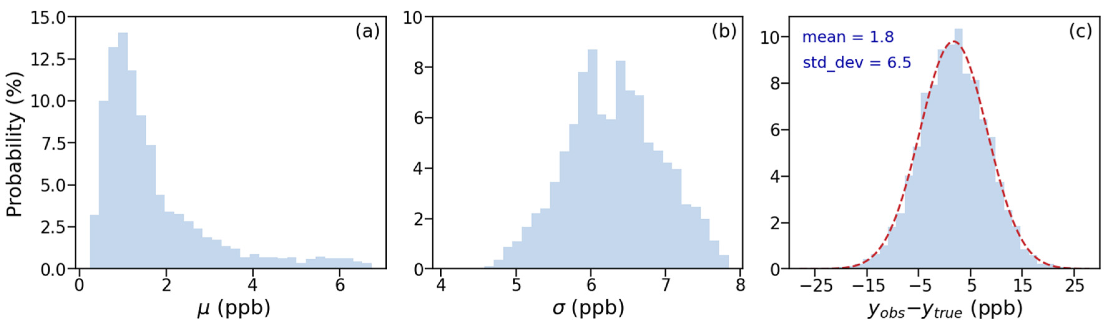
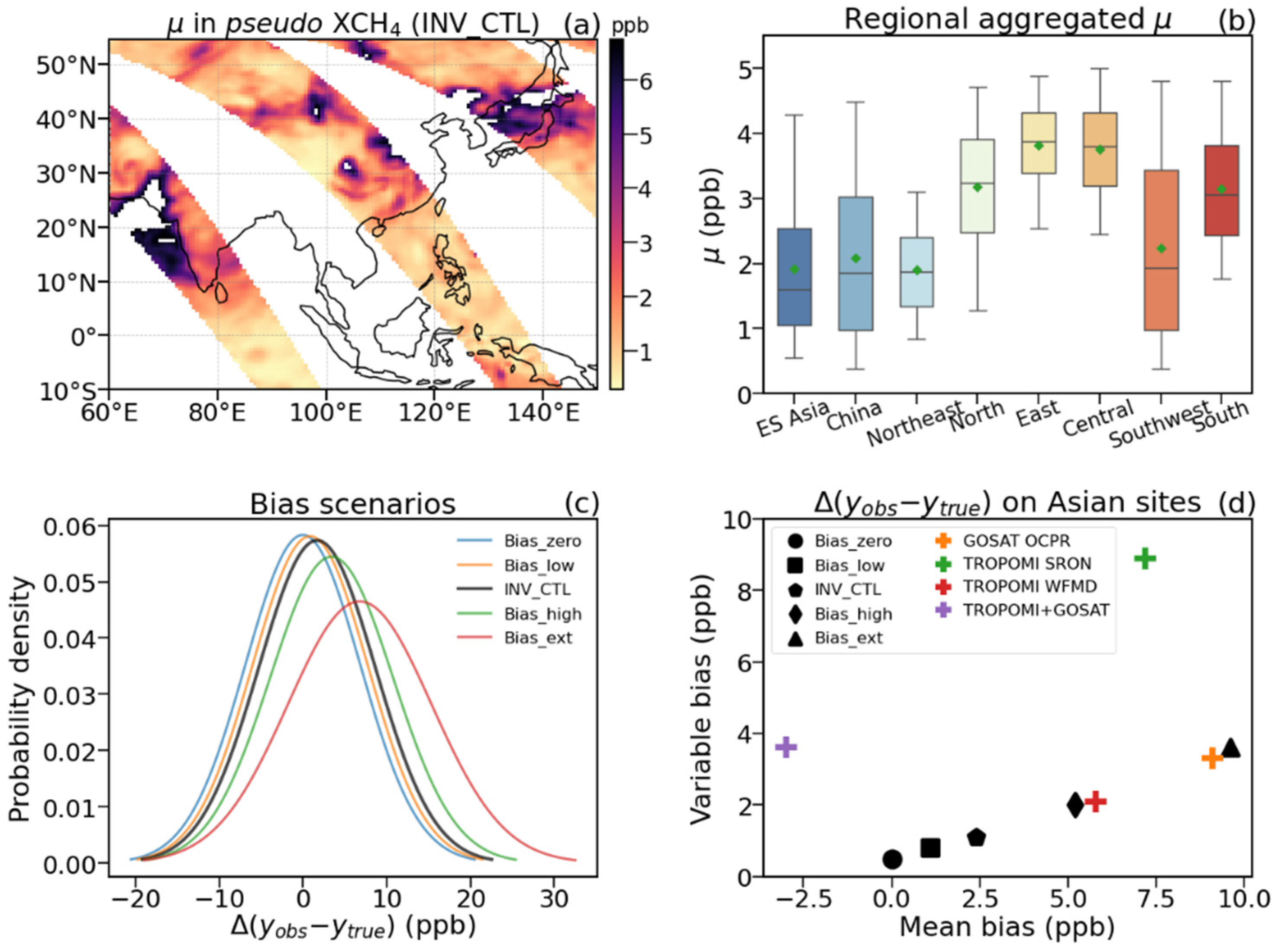
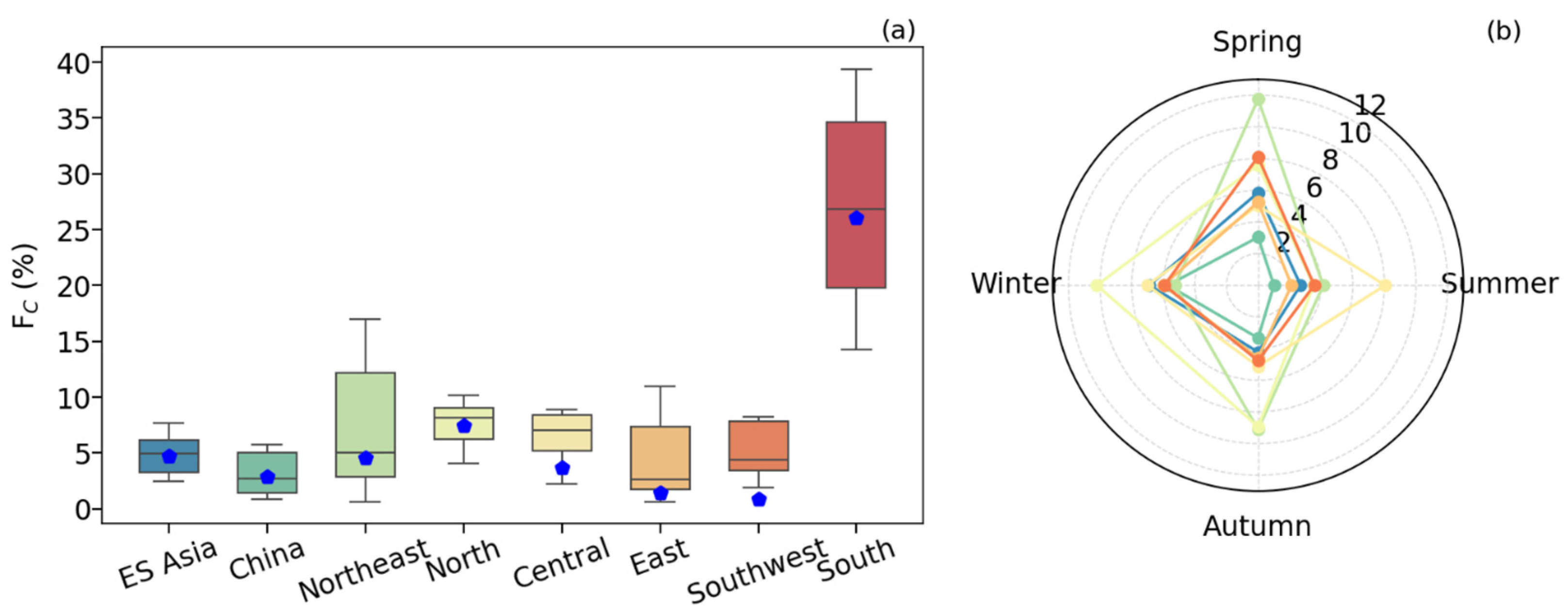
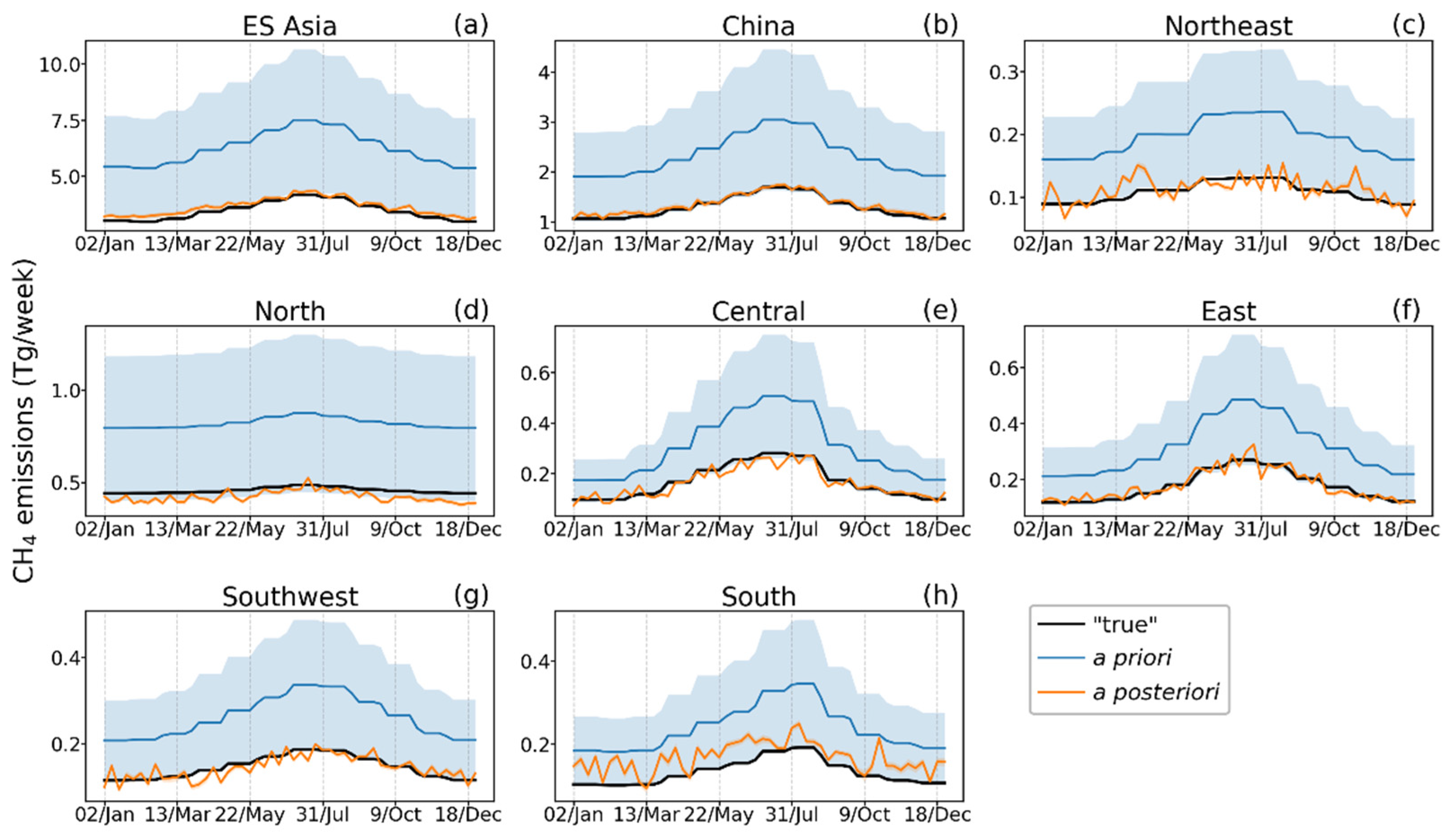
3.1. Control Experiment

The boxplot in Figure 5a illustrates the distribution of relative accuracy ( F c ) for weekly inverted CH4 fluxes under the INV_CTL scenario, aggregated by month. Blue pentagons indicate F c values for annual totals. At the regional scale across ES Asia, the annual a posteriori estimate achieves a relative accuracy of 4.7% ± 3.1% compared to the “true” emissions, improving substantially from a priori estimates with a F c of 80%, corresponding to an 86% reduction in a priori uncertainty. Over China (Figure 5a), inversion accuracy is even higher, with an annual F c of 2.9% ± 4.2% ( γ = 0.84). This improvement is largely attributed to enhanced observational sensitivity in the mid-latitudes of the Northern Hemisphere, enabled by TanSat-2’s elliptical medium Earth orbit (MEO) configuration (Figure 3a). Weekly a posteriori flux estimates over these two regions (ES Asia and China) also closely align with the “true” values (Figure 6a,b), demonstrating TanSat-2’s high potential for quantifying CH4 emissions at this regional scale under finer temporal resolutions.
Among the six major methane-emitting regions in China (Figure 5a), South China shows the largest discrepancy between a posteriori and “true” CH4 emissions, with an annual Fc of 26.1% ± 6.7%. As shown in Figure 6h, the a posteriori estimates are systematically biased upward, exceeding the “true” values by 26.9% [13.7–45.5%], where the range in brackets represents the 5th–95th percentile in monthly F c values. This indicates a partial but incomplete correction of the a priori biases. In contrast, North China displays consistent negative biases in the a posteriori estimates, particularly in winter (Figure 6d), resulting in an annual F c of 7.4% ± 2.4%, with winter values exceeding 10% (Figure 5b).
In comparison, other regions demonstrate high inversion accuracy in annual estimates, with F c values below 4.6% ± 4.8% (Northeast China) and as low as 0.9% ± 4.6% in Southwest China. However, this accuracy declines at finer temporal resolutions (Figure 6c,g): in Southwest China, F c increases to 4.4% [1.9–10.4%] at the monthly scale (Figure 5a), primarily due to fluctuations in a posteriori estimates relative to the “true” fluxes (Figure 6g). Similar patterns are observed in Central China (annual F c = 3.6% ± 3.5%) and East China (1.4% ± 3.9%), where greater variability at finer temporal resolutions leads to elevated F c values (Figure 5a). Notably, these adjacent regions exhibited anti-phase weekly peaks in a posteriori estimates—particularly in July—highlighting potential inconsistencies in capturing weekly flux dynamics (Figure 6e,f).
Overall, inversion results under the INV_CTL scenario show that annual a posteriori estimates are highly accurate ( F c < 5%) across most regions in China, except North China and South China. While TanSat-2’s elliptical orbit (Figure 3a) enables robust weekly flux estimates at the national scale, three key limitations are evident: (1) persistent positive biases in South China; (2) reduced accuracy at finer temporal resolutions, as seen in Southwest China; (3) a seesaw pattern in weekly CH4 emissions between adjacent regions (e.g., Central and East China), reflecting the limited capacity for TanSat-2 to simultaneously resolve sub-weekly and sub-regional CH4 variability.

3.2. Sensitivity of a Posteriori Flux Estimates to XCH4 Systematic Errors

To assess the sensitivity of F c in the regional a posteriori estimates to XCH4 bias, we applied scaling factors of 0.0, 0.5, 2.0, and 4.0 to the median bias levels in the INV_CTL scenario. Across ES Asia, the regional bias was found to be approximately 1.7 times higher than the global levels, ranging from 0.0 ± 0.0 ppb under ideal conditions to 6.8 ± 5.1 ppb under extreme bias scenarios. Over ES Asia, the sensitivity of annual F c estimate to bias is 5.0% ppb−1, with spring exhibiting the strongest sensitivity at 7.0% ppb−1 (Figure 7). For China, inversion accuracy in annual CH4 emission estimates declines by 5.8% for every 1 ppb increase in global bias level across scenarios (Figure 7a), with winter showing the largest sensitivity (a decline rate of 8.7% ppb−1; Figure 7b).
The sensitivity to XCH4 bias varies substantially across different regions of China. The a posteriori estimates over Northeast and East China exhibit higher sensitivity to XCH4 bias, with Fc declining by 11.1% ppb−1 and 8.7% ppb−1, respectively. Northeast China shows the highest seasonal sensitivity in spring, with F c decreasing by 17.3% ppb−1, while East China is most sensitive in winter, with a decline rate of 17.2% ppb−1. Similarly, Central China also exhibits notable sensitivity during winter, with F c decreasing by 12.9% ppb−1. In contrast, South China shows consistently low inversion accuracy (~26% annually) due to the limited availability of valid XCH4 observations, resulting in weak sensitivity to bias across all scenarios.

3.3. Comparison with the Pseudo Situation of TROPOMI WFMD

The validation results (Table 2 and Figure 3d) show that the mean and variable biases in the TROPOMI WFMD XCH4 product over ES Asia closely align with those of the Bias_high scenario used in this study. To further evaluate the potential performance of TanSat-2 relative to current satellite capabilities, we conducted inversion experiments using pseudo TROPOMI WFMD XCH4 observations, following the configurations outlined in Table 4 (see Section 3.2 for details).
Figure 8 presents the annual F c values and corresponding γ results derived from pseudo TROPOMI observations under the WFMD_high (high bias) and WFMD_med (median bias) scenarios, alongside those from pseudo TanSat-2 observations under the INV_CTL (median bias) scenario. Across ES Asia, TanSat-2 achieves an annual emission accuracy of 4.7% ± 3.1%, outperforming TROPOMI WFMD-based estimates, which show accuracies of 11.2% ± 8.9% and 11.3% ± 8.9% under the WFMD_med and WFMD_high scenarios, respectively. Similarly, for China, smaller discrepancies in a posteriori emission estimates are found under the INV_CTL experiment compared to both WFMD_med (6.7% ± 8.2%) and WFMD_high (10.5% ± 8.9%) scenarios.
Regional analysis reveals that, relative to the WFMD_high scenario, TanSat-2 significantly improves inversion accuracy over Northeast, Central, East, Southwest, and South China. Under the WFMD_med scenario, the inversion accuracies for Central, East, and Southwest China improve and approach the performance levels of TanSat-2 (green cross in Figure 8), suggesting that these regions are particularly sensitive to XCH4 bias in current satellite retrievals. In contrast, even under median bias conditions, Northeast and South China continue to show larger discrepancies compared to the INV_CTL experiment. This highlights the advantages of TanSat-2’s finer spatial resolution (2 km × 2 km), which reduces cloud contamination and enhances the spatial coverage of valid XCH4 observations.
Further, incorporating seven pseudo near-surface CH4 observations (site locations from Zhang et al. (2022) [58]) under the WFMD_high scenario (Figure S5) leads to substantial improvements in inversion accuracy for Northeast and Central China. However, improvements in East and Southwest China are limited, indicating that existing near-surface observation networks are still insufficient for these regions. In South China, where no in situ measurements are available, the inversion accuracy remains low ( F c > 60%) across both WFMD scenarios. Even under the INV_CTL experiment (less affected by clouds), the annual F c for South China remains at 26.1%, underscoring an urgent need for additional in situ CH4 monitoring in this region.

4. Discussion and Conclusions

Satellite retrievals, characterized by high spatial density and global coverage, provide invaluable data for quantifying the global and regional methane budgets. However, biases in satellite XCH4 retrievals—especially spatially heterogeneous biases that are challenging to characterize and remove—can lead to the misattribution of methane emissions [18,19]. This challenge is particularly critical for China, the world’s largest anthropogenic CH4 emitter [22]. In this study, we employed a series of OSSEs based on the forthcoming TanSat-2 mission configuration, using an EnKF-based inversion framework coupled with the GEOS-Chem atmospheric chemistry transport model, to evaluate its potential for constraining CH4 emissions across different regions in China, as well as its robustness in XCH4 retrieval biases. Additionally, based on the assessment of four XCH4 products using TCCON observations, the pseudo-TROPOMI scenarios are set to evaluate the possible ability for national and regional emission optimization currently.
With a target precision of 8 ppb (INV_CTL), TanSat-2 could theoretically achieve an accuracy of 2.9% ± 4.2% in annual CH4 emission estimates over China, corresponding to an 84% reduction in a priori uncertainty. TanSat-2 demonstrates particularly strong performance over Northeast, Central, East, and Southwest China, where a posteriori estimates deviate by less than 5.0% from the “true” emissions. However, in South China, persistent cloud cover substantially limits observational coverage, resulting in larger discrepancies (26.1%). Similar limitations are evident in pseudo TROPOMI-based experiments, highlighting the need of enhanced ground-based CH4 monitoring to complement satellite observations [59,60].
Despite the high overall performance under the INV_CTL scenario, sensitivity analyses reveal that inversion accuracy in Northeast, Central, and East China remains vulnerable to XCH4 retrieval biases. The accuracy in China’s total emissions degrades by 5.8% for every 1 ppb increase in global bias levels across scenarios (Table 3). Notably, the regional bias over ES Asia is approximately 1.7 times higher than global levels. This regional vulnerability is independently confirmed through additional pseudo TROPOMI-based experiments. While incorporating near-surface CH4 observations from the China Meteorological Administration network [58] improves inversion accuracy in Northeast and Central China, the improvements in East China remain limited. This spatial heterogeneity aligns with findings by Zhang et al. (2023) [61], who highlighted critical monitoring gaps in Central and Eastern China. Our results suggest that expanding ground-based XCH4 measurements in these sensitive regions would reduce the satellite-observed XCH4 biases and improve the robustness of inversion results.
Overall, our OSSEs demonstrate that TanSat-2 has significant potential for optimizing annual and seasonal CH4 emission estimates across major source regions in China apart from South China, although its ability to capture sub-weekly and sub-regional variability remains limited (Figure 6). While our study focuses primarily on uncertainties arising from cloud and aerosol interference, additional atmospheric factors may further influence inversion accuracy. In addition, inversion configurations such as non-uniform spatiotemporal errors in a priori inventories and temporal resolution during inversion—beyond the scope of this work—may also influence performance and need future investigation. Despite these challenges, the finer spatial resolution and improved retrieval precision of TanSat-2 are expected to make significant advancements for satellite-based CH4 flux estimation. Continued evaluation of real TanSat-2 XCH4 observations will be crucial for fully realizing their practical utility in methane emission monitoring.

Supplementary Materials

The following supporting information can be downloaded at: https://www.mdpi.com/article/10.3390/rs17132321/s1, Figure S1: Scatterplot comparisons of XCH4 between satellite products—GOSAT OCPR v9.0, TROPOMI SRON 19_446, TROPOMI WFMD v1.8, and the blended TROPOMI+GOSAT product—and TCCON observations at six sites across ES Asia; Figure S2: Seasonal distribution of systematic errors (unit: ppb) in pseudo XCH4 over ES Aisa from the INV_CTL test; Figure S3: (a) Spatial distribution of the annual mean “true” CH4 flux (unit: g/m2/d) in OSSEs, and (b) regional division map used for estimating CH4 emissions; Figure S4: Distribution of difference between (a) the a priori estimates and the “true” state, and between (b) the a posteriori CH4 fluxes and the “true” state in INV_CTL scenario; Figure S5: (a) Relative accuracy (Fc) of annual inverted CH4 fluxes over ES Asia, China, and six key-emitting regions. (b) Corresponding error reduction metrics (weekly mean γ). Blue squares indicate results from the Bias_high scenario under pseudo TROPOMI WFMD XCH4 coverage. Green crosses show results from the same scenario with the addition of seven pseudo ground-based site near-surface CH4 recordings from the China Meteorology Administration network (site locations detailed in Table S3 of Zhang et al. (2022) [58]). Orange diamonds represent results from the CTL_INV scenario based on pseudo TanSat-2 XCH4 coverage.

Author Contributions

Conceptualization, D.Y. and S.Z.; methodology, S.Z. and L.F.; data curation, D.Y.; visualization, S.Z.; formal analysis, S.Z. and D.Y.; funding acquisition, D.Y. and S.Z.; writing—original draft preparation, S.Z. and D.Y.; writing—review and editing, S.Z., D.Y., L.T., L.F., Y.L., J.C., M.Z., Z.C., K.W. and P.I.P. All authors have read and agreed to the published version of the manuscript.

Funding

This work was supported by the National Key R&D Program of China (grant no. 2023YFB3907405), the Chinese Academy of Sciences Project for Young Scientists in Basic Research (YSBR-037), and the China Postdoctoral Science Foundation (E3442418). L.F. and P.I.P. received support from the UK National Centre for Earth Observation funded by the National Environment Research Council (grant no. NE/R016518/1).

Data Availability Statement

Aerosol and cloud data are available from https://gmao.gsfc.nasa.gov/reanalysis/MERRA-2/ (accessed on 23 May 2024). The community-led GEOS-Chem model of atmospheric chemistry is maintained centrally by Harvard University (geoschem.github.io) and is available on request. The ensemble Kalman filter code is publicly available at https://github.com/Rainbow1994/EnKF_CH4.git (accessed on 12 March 2024).

Acknowledgments

We thank the GEOS-Chem community, in particular the Harvard University team which helps maintain the GEOS-Chem model, and the NASA Global Modeling and Assimilation Office (GMAO) for providing the MERRA2 data product.

Conflicts of Interest

The authors declare no conflicts of interest.

References

  1. WMO. W.M. No. 20–28 October 2024. Available online: https://library.wmo.int/records/item/69057-no-20-28-october-2024 (accessed on 13 November 2024).
  2. Canadell, J.; Monteiro, P.; Costa, M.; Cotrim da Cunha, L.; Cox, P.; Eliseev, A.; Henson, S.; Ishii, M.; Jaccard, S.; Koven, C.; et al. Global Carbon and Other Biogeochemical Cycles and Feedbacks; IPCC: Geneva, Switzerland, 2021. [Google Scholar]
  3. Nisbet, E.G.; Manning, M.R.; Dlugokencky, E.J.; Fisher, R.E.; Lowry, D.; Michel, S.E.; Myhre, C.L.; Platt, S.M.; Allen, G.; Bousquet, P.; et al. Very Strong Atmospheric Methane Growth in the 4 Years 2014–2017: Implications for the Paris Agreement. Glob. Biogeochem. Cycles 2019, 33, 318–342. [Google Scholar] [CrossRef]
  4. Ganesan, A.L.; Schwietzke, S.; Poulter, B.; Arnold, T.; Lan, X.; Rigby, M.; Vogel, F.R.; van der Werf, G.R.; Janssens-Maenhout, G.; Boesch, H.; et al. Advancing Scientific Understanding of the Global Methane Budget in Support of the Paris Agreement. Glob. Biogeochem. Cycles 2019, 33, 1475–1512. [Google Scholar] [CrossRef]
  5. Palmer, P.I.; Feng, L.; Lunt, M.F.; Parker, R.J.; Bösch, H.; Lan, X.; Lorente, A.; Borsdorff, T. The Added Value of Satellite Observations of Methane Forunderstanding the Contemporary Methane Budget. Philos. Trans. R. Soc. A Math. Phys. Eng. Sci. 2021, 379, 20210106. [Google Scholar] [CrossRef]
  6. Jacob, D.J.; Varon, D.J.; Cusworth, D.H.; Dennison, P.E.; Frankenberg, C.; Gautam, R.; Guanter, L.; Kelley, J.; McKeever, J.; Ott, L.E.; et al. Quantifying Methane Emissions from the Global Scale down to Point Sources Using Satellite Observations of Atmospheric Methane. Atmos. Chem. Phys. 2022, 22, 9617–9646. [Google Scholar] [CrossRef]
  7. Yokota, T.; Yoshida, Y.; Eguchi, N.; Ota, Y.; Tanaka, T.; Watanabe, H.; Maksyutov, S. Global Concentrations of CO2 and CH4 Retrieved from GOSAT: First Preliminary Results. Sola 2009, 5, 160–163. [Google Scholar] [CrossRef]
  8. Imasu, R.; Matsunaga, T.; Nakajima, M.; Yoshida, Y.; Shiomi, K.; Morino, I.; Saitoh, N.; Niwa, Y.; Someya, Y.; Oishi, Y.; et al. Greenhouse Gases Observing SATellite 2 (GOSAT-2): Mission Overview. Prog. Earth Planet. Sci. 2023, 10, 33. [Google Scholar] [CrossRef]
  9. Feng, L.; Palmer, P.I.; Zhu, S.; Parker, R.J.; Liu, Y. Tropical Methane Emissions Explain Large Fraction of Recent Changes in Global Atmospheric Methane Growth Rate. Nat. Commun. 2022, 13, 1378. [Google Scholar] [CrossRef]
  10. Feng, L.; Palmer, P.I.; Bösch, H.; Parker, R.J.; Webb, A.J.; Correia, C.S.C.; Deutscher, N.M.; Domingues, L.G.; Feist, D.G.; Gatti, L.V.; et al. Consistent Regional Fluxes of CH4 and CO2 Inferred from GOSAT Proxy XCH4: XCO2 Retrievals, 2010–2014. Atmos. Chem. Phys. 2017, 17, 4781–4797. [Google Scholar] [CrossRef]
  11. Zhang, Y.; Jacob, D.J.; Lu, X.; Maasakkers, J.D.; Scarpelli, T.R.; Sheng, J.-X.; Shen, L.; Qu, Z.; Sulprizio, M.P.; Chang, J.; et al. Attribution of the Accelerating Increase in Atmospheric Methane during 2010–2018 by Inverse Analysis of GOSAT Observations. Atmos. Chem. Phys. 2021, 21, 3643–3666. [Google Scholar] [CrossRef]
  12. Lorente, A.; Borsdorff, T.; Butz, A.; Hasekamp, O.; aan de Brugh, J.; Schneider, A.; Wu, L.; Hase, F.; Kivi, R.; Wunch, D.; et al. Methane Retrieved from TROPOMI: Improvement of the Data Product and Validation of the First 2 Years of Measurements. Atmos. Meas. Tech. 2021, 14, 665–684. [Google Scholar] [CrossRef]
  13. Lunt, M.F.; Palmer, P.I.; Lorente, A.; Borsdorff, T.; Landgraf, J.; Parker, R.J.; Boesch, H. Rain-Fed Pulses of Methane from East Africa during 2018–2019 Contributed to Atmospheric Growth Rate. Environ. Res. Lett. 2021, 16, 024021. [Google Scholar] [CrossRef]
  14. Chen, Z.; Jacob, D.J.; Nesser, H.; Sulprizio, M.P.; Lorente, A.; Varon, D.J.; Lu, X.; Shen, L.; Qu, Z.; Penn, E.; et al. Methane Emissions from China: A High-Resolution Inversion of TROPOMI Satellite Observations. Atmos. Chem. Phys. 2022, 22, 10809–10826. [Google Scholar] [CrossRef]
  15. Hachmeister, J.; Schneising, O.; Buchwitz, M.; Burrows, J.P.; Notholt, J.; Buschmann, M. Zonal Variability of Methane Trends Derived from Satellite Data. Atmos. Chem. Phys. 2024, 24, 577–595. [Google Scholar] [CrossRef]
  16. Houweling, S.; Bergamaschi, P.; Chevallier, F.; Heimann, M.; Kaminski, T.; Krol, M.; Michalak, A.M.; Patra, P. Global Inverse Modeling of CH4 Sources and Sinks: An Overview of Methods. Atmos. Chem. Phys. 2017, 17, 235–256. [Google Scholar] [CrossRef]
  17. Jacob, D.J.; Turner, A.J.; Maasakkers, J.D.; Sheng, J.; Sun, K.; Liu, X.; Chance, K.; Aben, I.; McKeever, J.; Frankenberg, C. Satellite Observations of Atmospheric Methane and Their Value for Quantifying Methane Emissions. Atmos. Chem. Phys. 2016, 16, 14371–14396. [Google Scholar] [CrossRef]
  18. Qu, Z.; Jacob, D.J.; Shen, L.; Lu, X.; Zhang, Y.; Scarpelli, T.R.; Nesser, H.; Sulprizio, M.P.; Maasakkers, J.D.; Bloom, A.A.; et al. Global Distribution of Methane Emissions: A Comparative Inverse Analysis of Observations from the TROPOMI and GOSAT Satellite Instruments. Atmos. Chem. Phys. 2021, 21, 14159–14175. [Google Scholar] [CrossRef]
  19. Stavert, A.R.; Saunois, M.; Canadell, J.G.; Poulter, B.; Jackson, R.B.; Regnier, P.; Lauerwald, R.; Raymond, P.A.; Allen, G.H.; Patra, P.K.; et al. Regional Trends and Drivers of the Global Methane Budget. Glob. Change Biol. 2022, 28, 182–200. [Google Scholar] [CrossRef]
  20. Miller, S.M.; Michalak, A.M.; Detmers, R.G.; Hasekamp, O.P.; Bruhwiler, L.M.P.; Schwietzke, S. China’s Coal Mine Methane Regulations Have Not Curbed Growing Emissions. Nat. Commun. 2019, 10, 303. [Google Scholar] [CrossRef]
  21. Yin, Y.; Chevallier, F.; Ciais, P.; Bousquet, P.; Saunois, M.; Zheng, B.; Worden, J.; Bloom, A.A.; Parker, R.J.; Jacob, D.J.; et al. Accelerating Methane Growth Rate from 2010 to 2017: Leading Contributions from the Tropics and East Asia. Atmos. Chem. Phys. 2021, 21, 12631–12647. [Google Scholar] [CrossRef]
  22. Sheng, J.; Tunnicliffe, R.; Ganesan, A.L.; Maasakkers, J.D.; Shen, L.; Prinn, R.G.; Song, S.; Zhang, Y.; Scarpelli, T.; Bloom, A.A.; et al. Sustained Methane Emissions from China after 2012 despite Declining Coal Production and Rice-Cultivated Area. Environ. Res. Lett. 2021, 16, 104018. [Google Scholar] [CrossRef]
  23. Liang, R.; Zhang, Y.; Chen, W.; Zhang, P.; Liu, J.; Chen, C.; Mao, H.; Shen, G.; Qu, Z.; Chen, Z.; et al. East Asian Methane Emissions Inferred from High-Resolution Inversions of GOSAT and TROPOMI Observations: A Comparative and Evaluative Analysis. Atmos. Chem. Phys. 2023, 23, 8039–8057. [Google Scholar] [CrossRef]
  24. Wunch, D.; Toon, G.; Blavier, J.-F.; Washenfelder, R.; Notholt, J.; Connor, B.; Griffith, D.; Sherlock, V.; Wennberg, P. The Total Carbon Column Observing Network. Philos. Trans. Ser. A Math. Phys. Eng. Sci. 2011, 369, 2087–2112. [Google Scholar] [CrossRef] [PubMed]
  25. Dils, B.; Buchwitz, M.; Reuter, M.; Schneising, O.; Boesch, H.; Parker, R.; Guerlet, S.; Aben, I.; Blumenstock, T.; Burrows, J.P.; et al. The Greenhouse Gas Climate Change Initiative (GHG-CCI): Comparative Validation of GHG-CCI SCIAMACHY/ENVISAT and TANSO-FTS/GOSAT CO2 and CH4 Retrieval Algorithm Products with Measurements from the TCCON. Atmos. Meas. Tech. 2014, 7, 1723–1744. [Google Scholar] [CrossRef]
  26. Reuter, M.; Buchwitz, M.; Schneising, O.; Noël, S.; Bovensmann, H.; Burrows, J.P.; Boesch, H.; Di Noia, A.; Anand, J.; Parker, R.J.; et al. Ensemble-Based Satellite-Derived Carbon Dioxide and Methane Column-Averaged Dry-Air Mole Fraction Data Sets (2003–2018) for Carbon and Climate Applications. Atmos. Meas. Tech. 2020, 13, 789–819. [Google Scholar] [CrossRef]
  27. Parker, R.J.; Webb, A.; Boesch, H.; Somkuti, P.; Barrio Guillo, R.; Di Noia, A.; Kalaitzi, N.; Anand, J.S.; Bergamaschi, P.; Chevallier, F.; et al. A Decade of GOSAT Proxy Satellite CH4 Observations. Earth Syst. Sci. Data 2020, 12, 3383–3412. [Google Scholar] [CrossRef]
  28. Lorente, A.; Borsdorff, T.; Martinez-Velarte, M.C.; Landgraf, J. Accounting for Surface Reflectance Spectral Features in TROPOMI Methane Retrievals. Atmos. Meas. Tech. 2023, 16, 1597–1608. [Google Scholar] [CrossRef]
  29. Schneising, O.; Buchwitz, M.; Hachmeister, J.; Vanselow, S.; Reuter, M.; Buschmann, M.; Bovensmann, H.; Burrows, J.P. Advances in Retrieving XCH4 and XCO from Sentinel-5 Precursor: Improvements in the Scientific TROPOMI/WFMD Algorithm. Atmos. Meas. Tech. 2023, 16, 669–694. [Google Scholar] [CrossRef]
  30. Balasus, N.; Jacob, D.J.; Lorente, A.; Maasakkers, J.D.; Parker, R.J.; Boesch, H.; Chen, Z.; Kelp, M.M.; Nesser, H.; Varon, D.J. A Blended TROPOMI+GOSAT Satellite Data Product for Atmospheric Methane Using Machine Learning to Correct Retrieval Biases. Atmos. Meas. Tech. 2023, 16, 3787–3807. [Google Scholar] [CrossRef]
  31. Zhu, S.; Yang, D.; Feng, L.; Tian, L.; Liu, Y.; Cao, J.; Wu, K.; Cai, Z.; Palmer, P.I. Towards the Optimization of TanSat-2: Assessment of a Large-Swath Methane Measurement. Remote Sens. 2025, 17, 543. [Google Scholar] [CrossRef]
  32. Hu, H.; Landgraf, J.; Detmers, R.; Borsdorff, T.; de Brugh, J.A.; Aben, I.; Butz, A.; Hasekamp, O. Toward Global Mapping of Methane With TROPOMI: First Results and Intersatellite Comparison to GOSAT. Geophys. Res. Lett. 2018, 45, 3682–3689. [Google Scholar] [CrossRef]
  33. Schneising, O.; Buchwitz, M.; Reuter, M.; Bovensmann, H.; Burrows, J.P.; Borsdorff, T.; Deutscher, N.M.; Feist, D.G.; Griffith, D.W.T.; Hase, F.; et al. A Scientific Algorithm to Simultaneously Retrieve Carbon Monoxide and Methane from TROPOMI Onboard Sentinel-5 Precursor. Atmos. Meas. Tech. 2019, 12, 6771–6802. [Google Scholar] [CrossRef]
  34. Zhou, M.; Wang, P.; Nan, W.; Yang, Y.; Kumps, N.; Hermans, C.; De Mazière, M. TCCON Data from Xianghe, China; Release GGG2020R0. TCCON Data Archive, Hosted by CaltechDATA; California Institute of Technology: Pasadena, CA, USA, 2022. [Google Scholar]
  35. Liu, C.; Wang, W.; Sun, Y.; Shan, C. TCCON Data from Hefei, China; Release GGG2020R0; TCCON Data Archive, Hosted by CaltechDATA; California Institute of Technology: Pasadena, CA, USA, 2023. [Google Scholar]
  36. Shiomi, K.; Kawakami, S.; Ohyama, H.; Arai, K.; Okumura, H.; Ikegami, H.; Usami, M. TCCON Data from Saga, Japan; Release GGG2020R0. TCCON Data Archive, Hosted by CaltechDATA; California Institute of Technology: Pasadena, CA, USA, 2022. [Google Scholar]
  37. Morino, I.; Ohyama, H.; Hori, A.; Ikegami, H. TCCON Data from Rikubetsu, Hokkaido, Japan; Release GGG2020R0. TCCON Data Archive, Hosted by CaltechDATA; California Institute of Technology: Pasadena, CA, USA, 2022. [Google Scholar]
  38. Morino, I.; Ohyama, H.; Hori, A.; Ikegami, H. TCCON Data from Tsukuba, Ibaraki, Japan, 125HR; Release GGG2020R0. TCCON Data Archive, Hosted by CaltechDATA; California Institute of Technology: Pasadena, CA, USA, 2022. [Google Scholar]
  39. Morino, I.; Velazco, V.A.; Hori, A.; Uchino, O.; Griffith, D.W.T. TCCON Data from Burgos, Philippines; Release GGG2020R0. TCCON Data Archive, Hosted by CaltechDATA; California Institute of Technology: Pasadena, CA, USA, 2022. [Google Scholar]
  40. Liu, Y.; Wang, J.; Yao, L.; Chen, X.; Cai, Z.; Yang, D.; Yin, Z.; Gu, S.; Tian, L.; Lu, N.; et al. The TanSat Mission: Preliminary Global Observations. Sci. Bull. 2018, 63, 1200–1207. [Google Scholar] [CrossRef]
  41. Yang, D.; Liu, Y.; Cai, Z.; Chen, X.; Yao, L.; Lu, D. First Global Carbon Dioxide Maps Produced from TanSat Measurements. Adv. Atmos. Sci. 2018, 35, 621–623. [Google Scholar] [CrossRef]
  42. Ran, Y. TanSat: A New Star in Global Carbon Monitoring from China. Sci. Bull. 2019, 64, 284–285. [Google Scholar] [CrossRef] [PubMed]
  43. Yang, D.; Boesch, H.; Liu, Y.; Somkuti, P.; Cai, Z.; Chen, X.; Di Noia, A.; Lin, C.; Lu, N.; Lyu, D.; et al. Toward High Precision XCO2 Retrievals from TanSat Observations: Retrieval Improvement and Validation Against TCCON Measurements. J. Geophys. Res. Atmos. 2020, 125, e2020JD032794. [Google Scholar] [CrossRef]
  44. Yang, D.; Liu, Y.; Boesch, H.; Yao, L.; Di Noia, A.; Cai, Z.; Lu, N.; Lyu, D.; Wang, M.; Wang, J.; et al. A New TanSat XCO2 Global Product towards Climate Studies. Adv. Atmos. Sci. 2021, 38, 8–11. [Google Scholar] [CrossRef]
  45. Yao, L.; Yang, D.; Liu, Y.; Wang, J.; Liu, L.; Du, S.; Cai, Z.; Lu, N.; Lyu, D.; Wang, M.; et al. A New Global Solar-Induced Chlorophyll Fluorescence (SIF) Data Product from TanSat Measurements. Adv. Atmos. Sci. 2021, 38, 341–345. [Google Scholar] [CrossRef]
  46. Wang, H.; Jiang, F.; Liu, Y.; Yang, D.; Wu, M.; He, W.; Wang, J.; Wang, J.; Ju, W.; Chen, J.M. Global Terrestrial Ecosystem Carbon Flux Inferred from TanSat XCO2 Retrievals. J. Remote Sens. 2022, 2022, 9816536. [Google Scholar] [CrossRef]
  47. Yang, D.; Hakkarainen, J.; Liu, Y.; Ialongo, I.; Cai, Z.; Tamminen, J. Detection of Anthropogenic CO2 Emission Signatures with TanSat CO2 and with Copernicus Sentinel-5 Precursor (S5P) NO2 Measurements: First Results. Adv. Atmos. Sci. 2023, 40, 1–5. [Google Scholar] [CrossRef]
  48. Wu, K.; Yang, D.; Liu, Y.; Cai, Z.; Zhou, M.; Feng, L.; Palmer, P.I. Evaluating the Ability of the Pre-Launch TanSat-2 Satellite to Quantify Urban CO2 Emissions. Remote Sens. 2023, 15, 4904. [Google Scholar] [CrossRef]
  49. Buchwitz, M.; Reuter, M.; Schneising, O.; Boesch, H.; Guerlet, S.; Dils, B.; Aben, I.; Armante, R.; Bergamaschi, P.; Blumenstock, T.; et al. The Greenhouse Gas Climate Change Initiative (GHG-CCI): Comparison and Quality Assessment of near-Surface-Sensitive Satellite-Derived CO2 and CH4 Global Data Sets. Remote Sens. Environ. 2015, 162, 344–362. [Google Scholar] [CrossRef]
  50. Aben, I.; Hasekamp, O.; Hartmann, W. Uncertainties in the Space-Based Measurements of CO2 Columns Due to Scattering in the Earth’s Atmosphere. J. Quant. Spectrosc. Radiat. Transf. 2007, 104, 450–459. [Google Scholar] [CrossRef]
  51. Butz, A.; Hasekamp, O.P.; Frankenberg, C.; Vidot, J.; Aben, I. CH4 Retrievals from Space-based Solar Backscatter Measurements: Performance Evaluation against Simulated Aerosol and Cirrus Loaded Scenes. J. Geophys. Res. 2010, 115, 2010JD014514. [Google Scholar] [CrossRef]
  52. Chander, G.; Hewison, T.J.; Fox, N.; Wu, X.; Xiong, X.; Blackwell, W.J. Overview of Intercalibration of Satellite Instruments. IEEE Trans. Geosci. Remote Sens. 2013, 51, 1056–1080. [Google Scholar] [CrossRef]
  53. von Clarmann, T.; Degenstein, D.A.; Livesey, N.J.; Bender, S.; Braverman, A.; Butz, A.; Compernolle, S.; Damadeo, R.; Dueck, S.; Eriksson, P.; et al. Overview: Estimating and Reporting Uncertainties in Remotely Sensed Atmospheric Composition and Temperature. Atmos. Meas. Tech. 2020, 13, 4393–4436. [Google Scholar] [CrossRef]
  54. Kiefer, M.; von Clarmann, T.; Funke, B.; García-Comas, M.; Glatthor, N.; Grabowski, U.; Kellmann, S.; Kleinert, A.; Laeng, A.; Linden, A.; et al. IMK/IAA MIPAS Temperature Retrieval Version 8: Nominal Measurements. Atmos. Meas. Tech. 2021, 14, 4111–4138. [Google Scholar] [CrossRef]
  55. The International GEOS-Chem User Community Geoschem/Geos-Chem: GEOS-Chem 12.5.0. 2019. Available online: http://www.geos-chem.org (accessed on 14 December 2019).
  56. Feng, L.; Palmer, P.; Boesch, H.; Dance, S. Estimating Surface CO2 Fluxes from Space-Borne CO2 Dry Air Mole Fraction Observations Using an Ensemble Kalman Filter. Atmos. Chem. Phys. 2009, 9, 2619–2633. [Google Scholar] [CrossRef]
  57. Zhu, S.; Feng, L.; Liu, Y.; Wang, J.; Yang, D. Decadal Methane Emission Trend Inferred from Proxy GOSAT XCH4 Retrievals: Impacts of Transport Model Spatial Resolution. Adv. Atmos. Sci. 2022, 39, 1343–1359. [Google Scholar] [CrossRef]
  58. Zhang, Y.; Fang, S.; Chen, J.; Lin, Y.; Chen, Y.; Liang, R.; Jiang, K.; Parker, R.J.; Boesch, H.; Steinbacher, M.; et al. Observed Changes in China’s Methane Emissions Linked to Policy Drivers. Proc. Natl. Acad. Sci. USA 2022, 119, e2202742119. [Google Scholar] [CrossRef]
  59. Yang, D.; Zhao, T.; Yao, L.; Guo, D.; Fan, M.; Ren, X.; Li, M.; Wu, K.; Wang, J.; Cai, Z.; et al. Toward Establishing a Low-Cost UAV Coordinated Carbon Observation Network (LUCCN): First Integrated Campaign in China. Adv. Atmos. Sci. 2024, 41, 1–7. [Google Scholar] [CrossRef]
  60. Zhao, T.; Yang, D.; Guo, D.; Wang, Y.; Yao, L.; Ren, X.; Fan, M.; Cai, Z.; Wu, K.; Liu, Y. Low-Cost UAV Coordinated Carbon Observation Network: Carbon Dioxide Measurement with Multiple UAVs. Atmos. Environ. 2024, 332, 120609. [Google Scholar] [CrossRef]
  61. Zhang, X.; Zhou, C.; Zhang, Y.; Lu, X.; Xiao, X.; Wang, F.; Song, J.; Guo, Y.; Leung, K.K.M.; Cao, J.; et al. Where to Place Methane Monitoring Sites in China to Better Assist Carbon Management. Npj Clim. Atmos. Sci. 2023, 6, 32. [Google Scholar] [CrossRef]
Figure 1. Spatial distributions of XCH4 from (a) GOSAT OCPR, (b) TROPOMI SRON, (c) TROPOMI WFMD, and (d) Blended TROPOMI+GOSAT products, averaged over the period from June 2018 to May 2021 on a 0.5° × 0.625° (latitude × longitude) grid. Panels (eh) show boxplots of monthly XCH4 retrieval counts across four seasons (2018–2021), aggregated over six key methane-emitting regions (outlined in panel (a)). In each boxplot, the box represents the interquartile range (IQR; 25th–75th percentiles), the midline indicates the median, green markers denote the mean, and whiskers extend to the 5th and 95th percentile (defined as Q1 − 1.5 × IQR and Q3 + 1.5 × IQR, respectively). Note that different y-ranges are used in panels (eh).
Remotesensing 17 02321 g001
Figure 2. Probability distribution of (a) systematic errors, (b) random errors in pseudo XCH4, and (c) differences between pseudo and the “true” XCH4 observations over ES Aisa (longitude: 60°E–90°E; latitude: 10°S–55°N) on 1 July 2017. Note the differences in y-ranges. The red dashed line in panel (c) represents normal distribution curve fitted to the difference ( y ), parameterized by μ of 1.8 ppb, and σ of 6.5 ppb.
Remotesensing 17 02321 g002
Figure 3. (a) Spatial distribution of systematic errors ( μ ) in pseudo XCH4 retrievals under cloud- and aerosol-free conditions (AOD@550 nm < 0.5) on 1 July 2017, averaged on 0.5° × 0.625° (latitude × longitude) grid for TanSat-2 elliptical MEOs. (b) Boxplot of μ values aggregated over ES Asia, China, and six key methane-emitting regions (outlined in Figure 1a). The interpretation of the box, midline, markers, and whiskers follows the same convention as in Figure 1e–h. (c) Probability distribution of the differences between pseudo and the “true” XCH4 observations over Eastern and Southern Aisa (longitude: 60°E–90°E; latitude: 10°S–55°N) under five bias scenarios. (d) Mean and variable bias when pseudo-observations are sampled to six Asian TCCON stations, along with corresponding values for GOSAT OCPR, TROPOMI SRON, TROPOMI WFMD, and the blended TROPOMI+GOSAT datasets, as summarized in Table 2.
Remotesensing 17 02321 g003
Figure 4. Schematic of OSSEs. The left column (blue arrows) outlines the generation of pseudo-observation ( y o b s ) using the observation operator ( H ), which maps the “true” flux ( X t ) to observed XCH4. R represents the observation error. The right column (green arrows) denotes the model forecast process based on the a priori estimate ( X f ), which is 80% larger than X t , along with the associated error. The middle column (black arrows) represents the iterative assimilation process based on the EnKF algorithm to generate the a posteriori estimate ( X a ) and its uncertainties ( P a ). The black boxes indicate variables, and the shaded areas denote calculation processes within the OSSEs [31].
Remotesensing 17 02321 g004
Figure 5. Relative precision ( F c ) of a posteriori CH4 emissions under the INV_CTL scenario, incorporating median systematic ( μ = 1.7 ± 1.3 ppb) and random ( σ = 6.8 ± 0.7 ppb) errors in XCH4 retrievals. (a) Boxplot of monthly F c values and corresponding annual totals (blue pentagon) for ES Asia, China, and six major methane-emitting regions. In each boxplot, the box represents the interquartile range (IQR; 25th–75th percentiles), the midline indicates the median, and whiskers extend to the 5th and 95th percentile. (b) Radar chart of seasonal patterns in F c values across all regions except South China.
Remotesensing 17 02321 g005
Figure 6. Regional variations in CH4 emissions across ES Asia, China, and six major methane-emitting regions under the INV_CTL scenario, incorporating median systematic ( μ = 1.7 ± 1.3 ppb) and random ( σ = 6.8 ± 0.7 ppb) errors in XCH4 retrievals. The blue line shows the a priori emissions, the orange line denotes the a posteriori estimates, and the black line illustrates the “true” emissions. Shaded areas around the blue and orange lines depict the associated uncertainties of the a priori and a posteriori estimates, respectively. Note the differences in y-ranges.
Remotesensing 17 02321 g006
Figure 7. Sensitivity of F c in the a posteriori CH4 emissions estimates to varying XCH4 bias levels. (a) Boxplots showing the distribution of slopes (% ppb−1) of the monthly F c values, along with corresponding annual totals (blue pentagon), for ES Asia, China, and six major methane-emitting regions. In each boxplot, the box represents the interquartile range (IQR; 25th–75th percentiles), the midline indicates the median, and whiskers extend to the 5th and 95th percentile. (b) Radar chart depicting the seasonal patterns of slopes in F c values across regions.
Remotesensing 17 02321 g007
Figure 8. (a) Relative accuracy ( F c ) of annual inverted CH4 fluxes over ES Asia, China, and six key-emitting regions. (b) Corresponding error reduction metrics (weekly mean γ ). Blue squares and green crosses indicate results from the Bias_high scenario and Bias_median (CTL_INV) scenario under pseudo TROPOMI WFMD XCH4 coverage. Orange diamonds represent results from the CTL_INV scenario based on pseudo TanSat-2 XCH4 coverage.
Remotesensing 17 02321 g008
Table 1. Overview of GOSAT OCPR, TROPOMI SRON and TROPOMI WFMD XCH4 products.
GOSAT OCPRTROPOMI SRONTROPOMI WFMDBlended
TROPOMI+GOSAT
Product versionv9.0v19_446v1.8TROPOMI v02.04.00 b GOSAT proxy v9.0 b
Local over pass time13:0013:3013:30/
Pixel size10.5 km diameter5.5 × 7 km2 c5.5 × 7 km2 c/
Return time3 d1 d1 d/
Retrieval band1.65 μm2.3 μm2.3 μm/
Retrieval algorithmCO2 proxyRemoTeCWFMDMachine learning–LightGBM d
Mean bias (ppb) a0.0 e−5.3/−2.9
Variable bias (ppb) a3.95.15.24.4
Single-retrieval precision (ppb) a17.411.912.411.9
PeriodApril 2009–December 2019March 2018–December 2020October 2017–April 2022January 2018–December 2021
Reference fParker et al. (2020) [27]Lorente et al. (2023) [28]Schneising et al. (2023) [29]Balasus et al. (2023) [30]
a Mean bias and variable bias denote the spatial mean and standard deviation of the temporally averaged differences relative to individual TCCON XCH4 recordings. Precision refers to the standard deviation of the differences between co-located satellite and TCCON XCH4 pairs. b Only observations flagged with a quality flag of 0 in the GOSAT proxy dataset are used. For TROPOMI data, only albedo bias-corrected data (“methane-mixing_ratio_bias_corrected”) with a quality assurance value of 1 are included. c At nadir, with a pixel size of 7 × 7 km2 before 6 August 2019. d The blended TROPOMI+GOSAT product is generated by training a machine learning model (LigthGBM) to predict the difference Δ (TROPOMI − GOSAT) between co-located GOSAT and TROPOMI XCH4 retrievals. The correction is applied by subtracting the predict difference from the complete operational TROPOMI v02.04.00 dataset. e A global bias of 9.06 ppb has been removed from the GOAST OCPR dataset. f The GGG2014 algorithm is used for TCOON XCH4 validation of GOSAT OCPR, TROPOMI SRON and TROPOMI WFMD products, while GGG2020 is used for the blended TROPOMI+GOSAT product.
Table 2. Overview of the validation results of the co-located GOSAT OCPR, TROPOMI SRON, and TROPOMI WFMD XCH4 measurements with the TCCON sites XCH4 recordings over Asia for the period from June 2018 to May 2021.
TCCON Site, Lat-lon Coord. (°)GOSAT OCPR a,bTROPOMI SRON a,cTROPOMI WFMD a,dBlended
TROPOMI+GOSAT a
No. of PointsBias
(ppb)
Standard Deviation
(ppb)
No. of PointsBias
(ppb)
Standard Deviation
(ppb)
No. of PointsBias
(ppb)
Standard Deviation
(ppb)
No. of PointsBias
(ppb)
Standard Deviation
(ppb)
Xianghe [34]
(39.8, 116.96)
1067.713.449−5.812.95676.515.1468−6.611.7
Hefei [35]
(31.9, 119.17)
0//488.912.9542.316.349−2.712.3
Saga [36]
(33.24, 130.29)
10411.29.23719.613.61838.911.81203.311.3
Rikubetsu [37]
(43.46, 143.77)
2214.113.7450.421.2617.116.7131−1.110.8
Tsukuba [38]
(36.05, 140.12)
595.69.11303.510.11475.79.5142−3.28.3
Burgos [39]
(18.53, 120.65)
427.15.71016.818.4254.012.168−7.49.1
station-to-station statistics 9.1 ± 3.310.2 ± 3.0 7.2 ± 8.914.8 ± 3.8 5.8 ± 2.113.6 ± 2.6 −3.0 ± 3.610.6 ± 1.4
a All four datasets are resampled to a 0.5° × 0.625° (latitude × longitude) grid for analysis. b The GOSAT OCPR v9.0 dataset includes only observations with a quality flag of 0. c The TROPOMI SRON dataset (14_446) includes only albedo bias-corrected data with a quality assurance value of 1. d The TROPOMI WFMD v1.8 dataset is filtered for observations with a quality flag of 0, apparent albedo above 0.02, surface roughness below 80, and XCH4 uncertainty under 14 ppb.
Table 3. Configurations of pseudo TanSat-2 XCH4 observations for OSSEs.
Sensitivity ExperimentsObservation Error (ppb) y o b s y t r u e (ppb)Sampled to TCCON Site (ppb)
μ σ Mean BiasVariable Bias
INV_CTL1.7 ± 1.36.8 ± 0.71.7 ± 7.02.41.1
Bias_zero0.0 ± 0.0/ a0.0 ± 6.80.00.5
Bias_low0.9 ± 0.7/0.9 ± 6.91.10.8
Bias_high3.4 ± 2.6/3.4 ± 7.35.22.0
Bias_ext6.8 ± 5.1/6.8 ± 8.69.63.6
a / represent the same configuration with it in INV_CTL.
Table 4. Configurations of pseudo TanSat-2 and TROPOMI XCH4 observations for OSSEs.
Sensitivity
Experiments
Spatial
Coverage
Bias
Scenario
Observation Error (ppb) y o b s y t r u e (ppb)
μ σ
WFMD_highTROPOMIBias_high3.7 ± 2.89.0 ± 1.83.7 ± 9.6
WFMD_medTROPOMIINV_CTL1.8 ± 1.49.0 ± 1.81.9 ± 9.3
INV_CTLTanSat-2INV_CTL1.7 ± 1.36.8 ± 0.71.7 ± 7.0
Disclaimer/Publisher’s Note: The statements, opinions and data contained in all publications are solely those of the individual author(s) and contributor(s) and not of MDPI and/or the editor(s). MDPI and/or the editor(s) disclaim responsibility for any injury to people or property resulting from any ideas, methods, instructions or products referred to in the content.

