1. Introduction
Lakes represent critical freshwater reservoirs that sustain industrial, agricultural, and domestic activities across diverse regions of the world’s terrestrial surface [
1]. However, the increasing frequency and severity of cyanobacterial blooms have emerged as a pressing global environmental issue, threatening aquatic ecosystems and posing significant public health risks [
2]. In China, rapid economic development and land-use change have accelerated eutrophication, particularly in freshwater lakes, where cyanobacterial blooms are becoming increasingly widespread. These events not only degrade aesthetic water quality but also release potent cyanotoxins that endanger human and animal health. Under certain conditions, large-scale cyanobacterial die-offs can deplete dissolved oxygen, resulting in hypoxia, black water, and offensive odors [
3].
Aquatic macrophytes are essential components of lake ecosystems, functioning as primary producers and providing critical habitat, food, and spawning grounds for fish, birds, and benthic organisms [
4]. By stabilizing sediments and limiting internal nutrient loading, macrophytes suppress phytoplankton growth through both resource competition and allelopathic interactions, thereby supporting ecological stability. A decline in aquatic vegetation can disrupt this balance, triggering abrupt regime shifts from clear, vegetation-dominated states to turbid, bloom-dominated conditions.
Monitoring the spatiotemporal dynamics of cyanobacterial blooms and aquatic vegetation is essential for effective ecological assessment and lake management. Traditional in situ surveys, while accurate, are often constrained by high costs and limited spatial coverage. In contrast, satellite remote sensing provides an efficient and scalable alternative, enabling timely and continuous monitoring across broad and inaccessible regions [
5].
Despite these advantages, most remote sensing studies have focused on detecting either cyanobacterial blooms or aquatic vegetation independently, with limited attention to their coexistence or spatial interactions [
6].
Numerous spectral indices have been developed for each target. For instance, the Maximum Chlorophyll Index (MCI) [
7], Spectral Shape Index (SS) [
8], Floating Algae Index (FAI) [
9], Adjusted FAI (AFAI) [
10], and the Commission Internationale de l’Éclairage Chromaticity Algorithm (CIE) [
11] have been widely used to map cyanobacterial blooms. The CIE-based method, in particular, has demonstrated promising capability in distinguishing algal blooms from aquatic vegetation in optically complex waters by leveraging colorimetric transformations [
12]. Concurrently, indices such as the Normalized Difference Vegetation Index (NDVI) [
13], Water Adjusted Vegetation Index (WAVI) [
14], and Submerged Vegetation Spectral Index (SVSI) [
15] have been proposed for aquatic vegetation detection. However, in optically complex inland waters where both cyanobacteria and macrophytes may co-occur, their similar spectral signatures often result in considerable classification uncertainty [
16]. Recently, Luo et al. [
17] developed a classification framework that distinguishes among algal blooms, floating-leaved, and submerged vegetation using Sentinel-2 data, offering a valuable reference for high-resolution aquatic ecosystem mapping. However, the method exhibits limitations in temporal stability, with reduced separation accuracy when applied to long-term time series data under varying environmental conditions.
One mitigation strategy assumes spatial segregation between the two components. In Lake Taihu, for example, cyanobacterial blooms are concentrated in the western basin, whereas aquatic vegetation dominates the eastern region [
18]. This spatial separation enables regionalized classification based on dominant features. However, such approaches rely heavily on prior ecological knowledge and may not generalize to more dynamic or heterogeneous systems [
19].
A more robust approach involves leveraging temporal dynamics. Aquatic macrophytes typically exhibit stable spatial distribution during their growing season, whereas cyanobacterial blooms fluctuate more significantly in both space and time [
20]. Building on this distinction, we introduce a novel Vegetation Frequency Index that captures the temporal persistence of aquatic vegetation during peak growth periods. By analyzing long-term satellite observations, this index enables effective separation of vegetation and bloom signals using optimized frequency thresholds.
Many satellite platforms are limited by coarse spatial resolution, infrequent revisit intervals, and narrow spectral ranges. These constraints reduce their effectiveness for monitoring small- and medium-sized lakes, where bloom and vegetation patches are often highly localized [
21,
22]. The Sentinel-2 satellite, equipped with the MultiSpectral Instrument (MSI), overcomes many of these limitations, offering high spatial resolution (10 m), frequent revisit intervals (≤5 days), and 13 spectral bands spanning the visible to shortwave infrared regions. These attributes make Sentinel-2 MSI particularly well-suited for detailed monitoring of inland waters.
Despite these technological advancements, conventional remote sensing workflows remain constrained by large data volumes, long processing times, and high storage demands—factors that hinder long-term, automated environmental monitoring. Recently, cloud-based platforms have emerged as promising solutions for efficiently managing large-scale satellite data processing [
23].
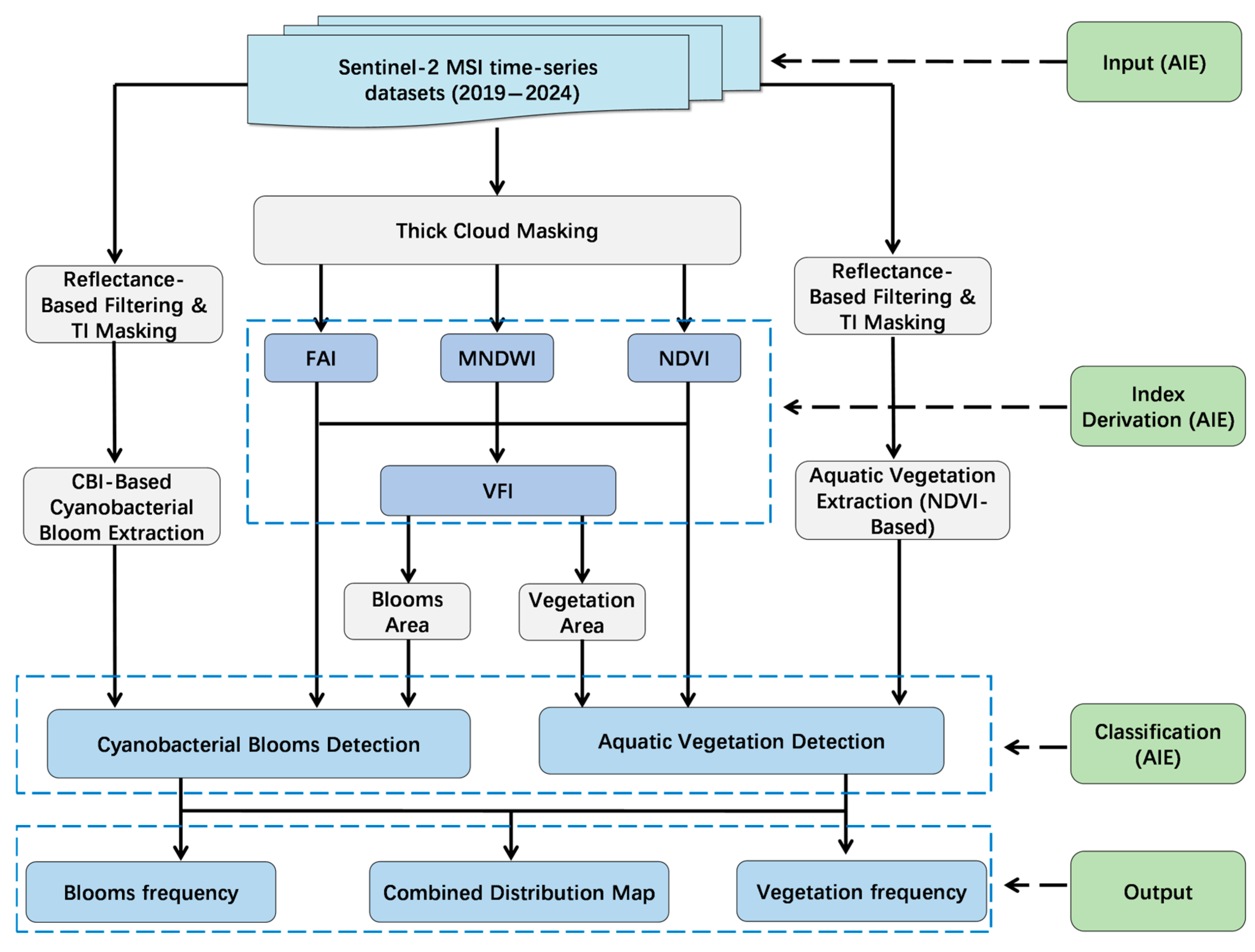
In this study, we integrate Sentinel-2 MSI data with the AI Earth (AIE) platform—a publicly accessible, cloud-based geospatial analysis system developed by Alibaba DAMO Academy—to establish a fully automated, long-term monitoring system for cyanobacterial blooms and aquatic vegetation. The AIE platform hosts petabytes of openly available remote sensing data (e.g., from Terra, Aqua, Landsat, and Sentinel satellites) and provides built-in online tools for data querying, preprocessing, visualization, and large-scale geospatial computation. Users can access the platform through its public interface (
https://aiearth.aliyun.com (accessed on 3 July 2025)) without the need for local downloads or manual intervention [
24].
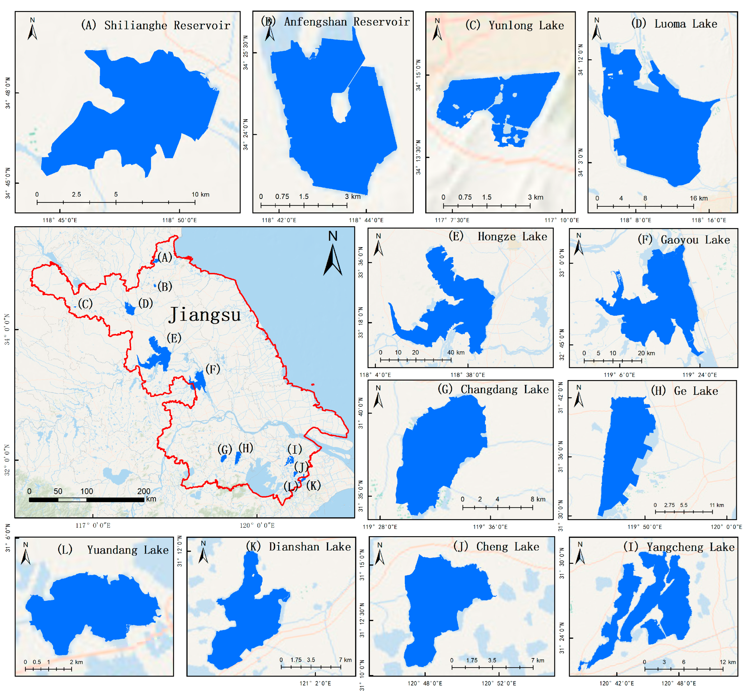
In accordance with the Notice on Strengthening the Prevention and Control of Algal Blooms in Key Lakes and Reservoirs in 2024 issued by the Ministry of Ecology and Environment of China (Document No. 78 [2024]), 42 key lakes and reservoirs in Jiangsu Province—excluding Lake Taihu—have been identified as high-priority areas for bloom control. Many of these lakes are small and poorly monitored by coarse-resolution sensors such as MODIS. To address this gap, we developed a cloud-based, interactive monitoring system that integrates Sentinel-2 imagery and the AIE platform to enable high-resolution, automated tracking of bloom and vegetation dynamics.
This system was applied to conduct a spatiotemporal analysis of 12 high-risk lakes in Jiangsu Province. The results offer critical insights to inform water quality assessment, support ecological restoration, and guide decision-making on the health and management of aquatic ecosystems.
3. Results
3.1. Verifying the Accuracy of Cyanobacterial Blooms and Aquatic Vegetation Extraction
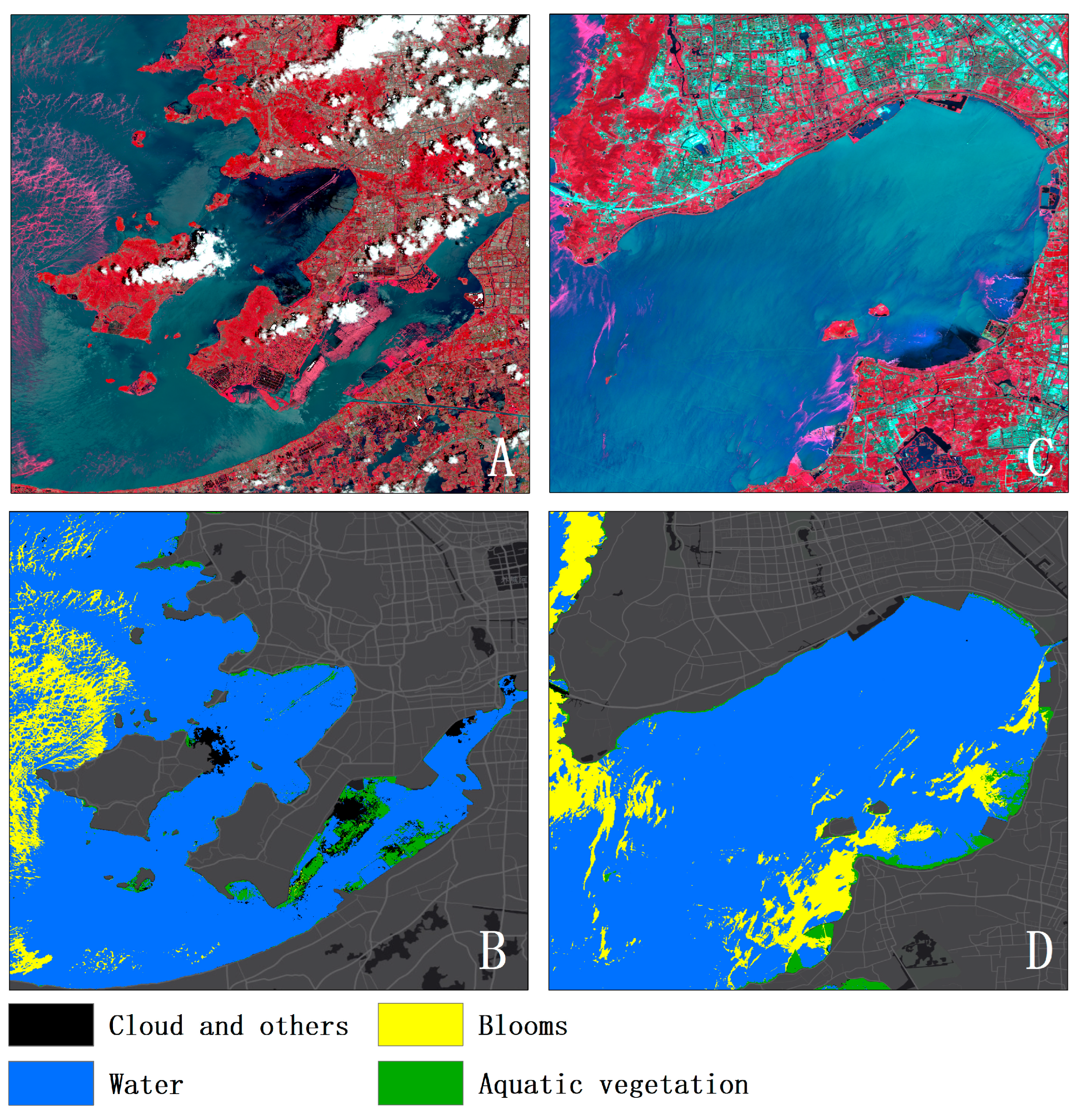
The accuracy of Cyanobacterial bloom extraction was assessed using ground truth data provided by the Wuxi Environmental Monitoring Center, derived from routine field surveys conducted across Taihu Lake between 2019 and 2024. A total of 523 validation samples were matched with satellite observations. Of these, 81 were identified as true positives (TP) and 428 as true negatives (TN), while 8 and 6 samples were misclassified as false positives (FP) and false negatives (FN), respectively. Based on these values, the precision, recall, F1-score, and Intersection over Union (IoU) were calculated as 0.910, 0.931, 0.920, and 0.853, respectively.
For aquatic vegetation classification, an additional 58 validation samples were obtained from targeted field campaigns conducted in May, September, and December 2023. Among them, 39 were true positives and 13 true negatives, with 2 false positives and 4 false negatives. The corresponding precision, recall, F1-score, and IoU were 0.951, 0.907, 0.929, and 0.867, respectively. These results highlight the robustness and high accuracy of the proposed algorithm in detecting cyanobacterial blooms and delineating aquatic vegetation in a large, dynamic freshwater ecosystem. It is important to note that the validation samples for aquatic vegetation primarily included floating and emergent macrophytes. Submerged vegetation, especially that located at greater depths, was excluded from validation due to difficulties in precise field geolocation and low spectral contrast under optically complex water conditions. Consequently, the reported accuracy metrics may not fully represent the algorithm’s performance in detecting submerged vegetation.
Figure 3 presents a comparison between the extraction results for cyanobacterial blooms and aquatic vegetation, demonstrating the effectiveness of the proposed method in distinguishing between the two classes. However, in certain areas of the lake, submerged vegetation was only partially extracted, revealing limitations in detecting submerged features under optically complex conditions. Despite these challenges, the high classification precision highlights the robustness of the method and its strong potential for practical application in aquatic ecosystem monitoring.
3.2. Spatiotemporal Dynamics of Cyanobacterial Blooms
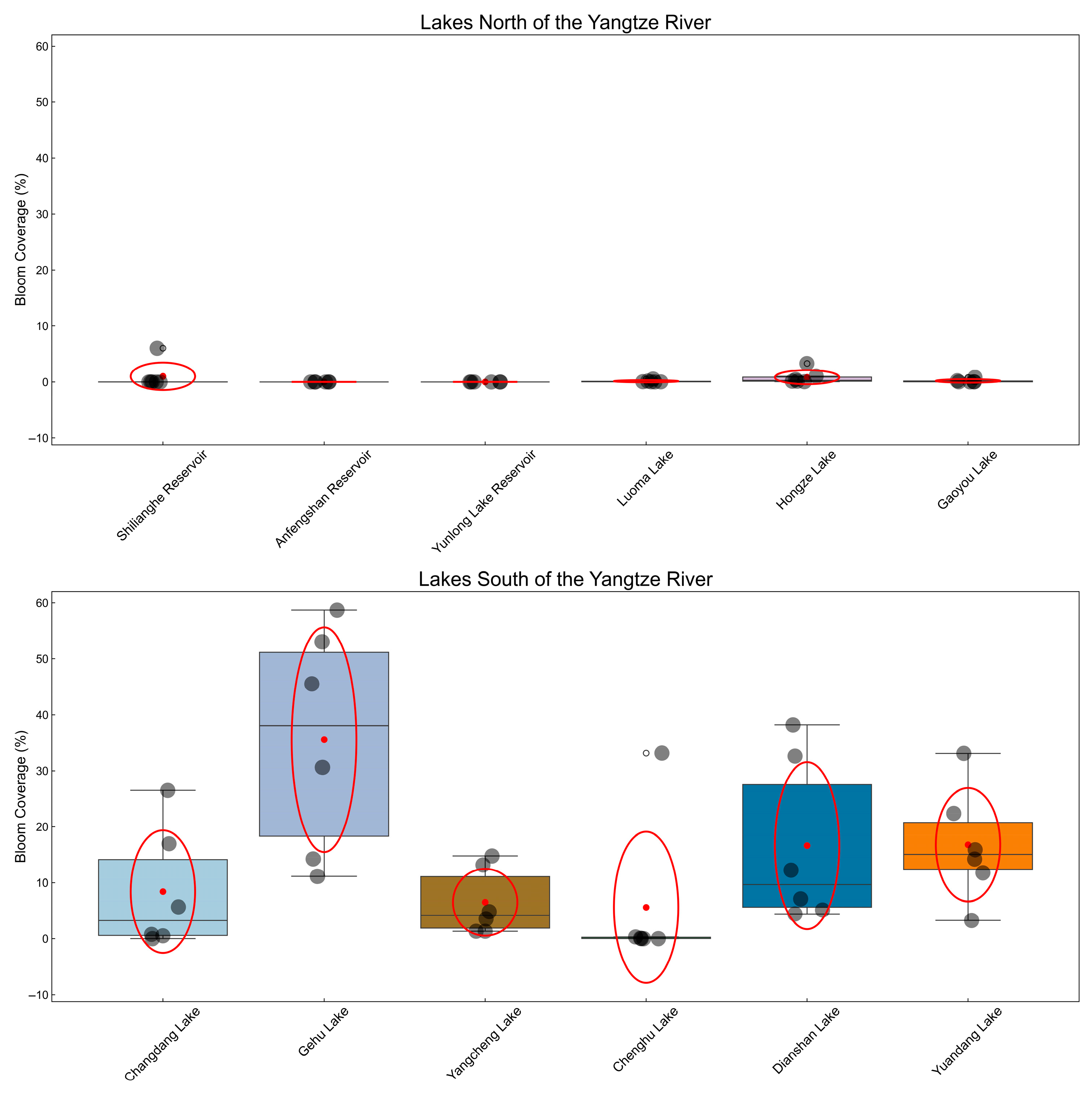
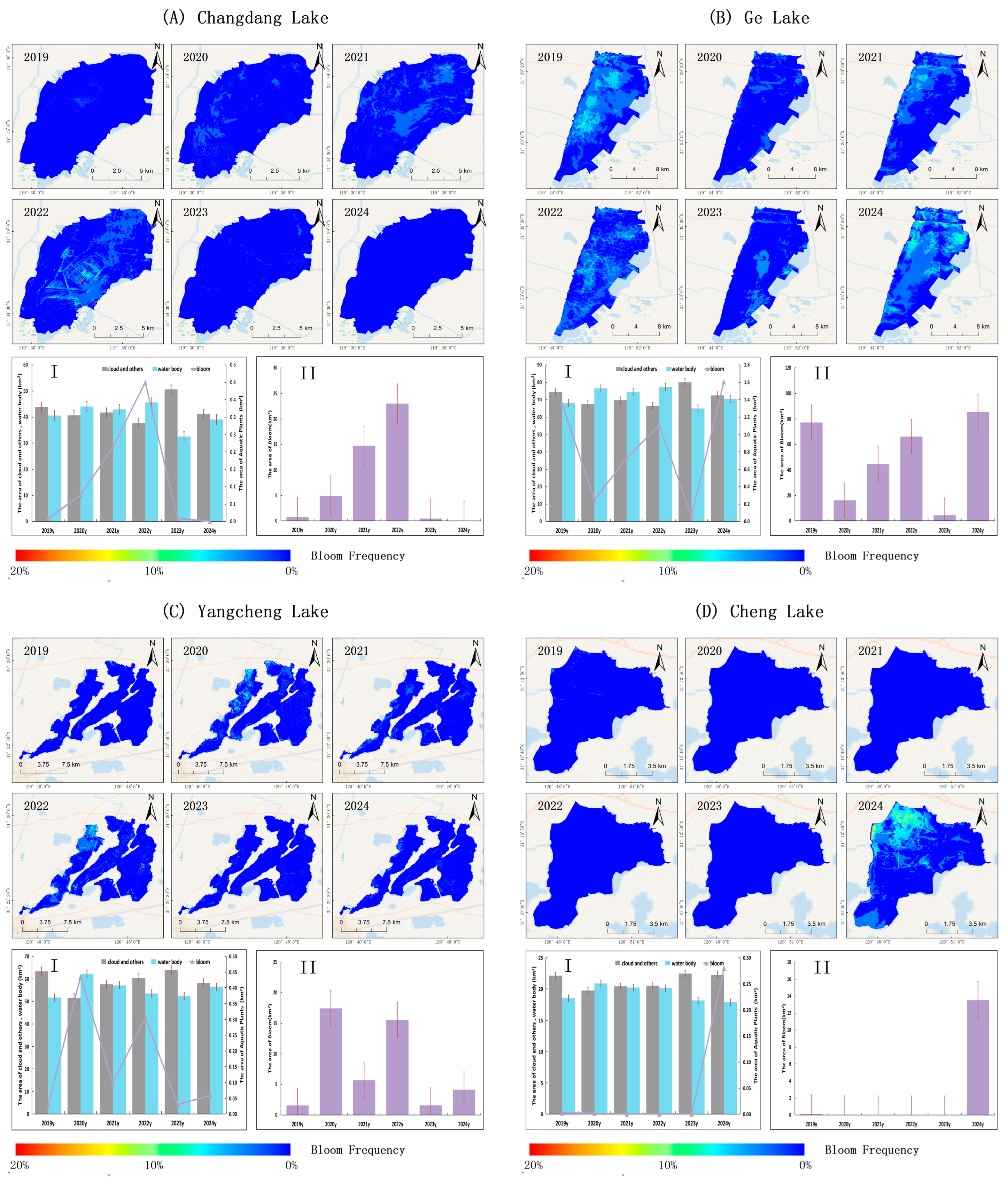
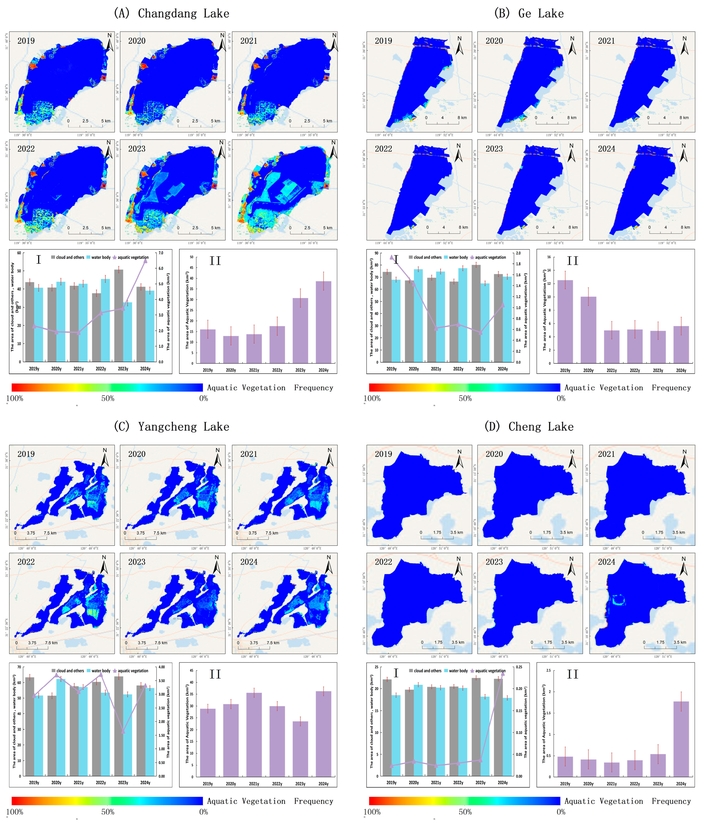
Figure 4 illustrates interannual variations in the extent of cyanobacterial bloom coverage across 12 major lakes and reservoirs in Jiangsu Province from 2019 to 2024. Gehu, Dianshan, Yuandang, Changdang, Yangcheng, and Chenghu lakes—located south of the Yangtze River—exhibited markedly higher bloom coverage than other water bodies. Gehu recorded the highest average proportion of bloom-affected area (33.68%), followed by Yuandang (16.77%), Dianshan (16.62%), Changdang (8.41%), Yangcheng (6.50%), and Chenghu (5.60%). This spatial clustering suggests a heightened vulnerability to recurrent and severe bloom events in the southern region.
Notably, Chenghu Lake exhibited no detectable bloom activity between 2019 and 2023, but in 2024, its bloom-affected area abruptly increased to 33.16%. This marked the first large-scale bloom event recorded at the site during the study period and may reflect a sudden ecological shift requiring urgent attention.
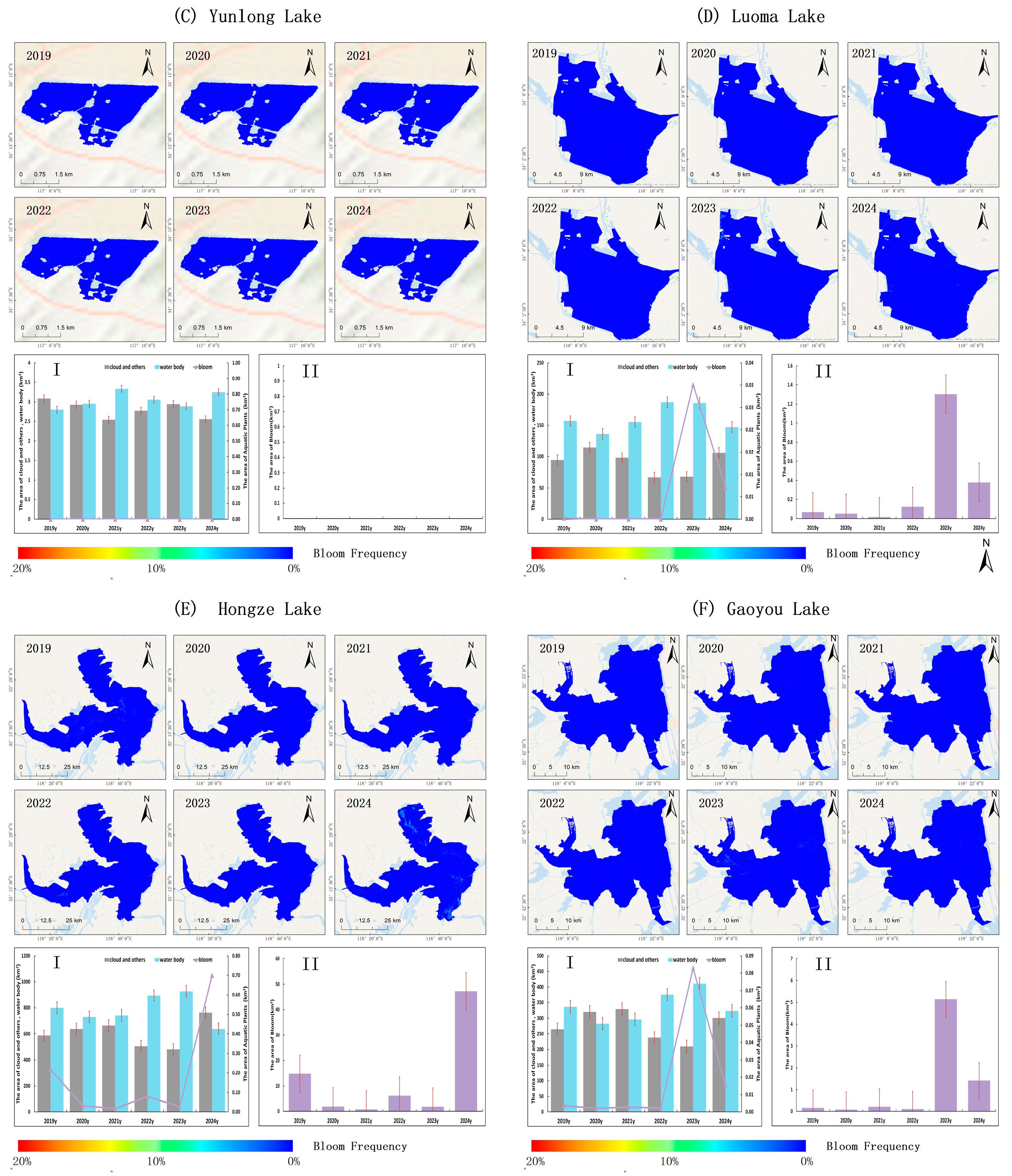
In contrast, lakes situated north of the Yangtze River—namely Hongze (0.84%), Gaoyou (0.19%), Luoma (0.13%), and Shilianghe Reservoir (1.01%)—remained largely unaffected throughout the observation window. No bloom events were detected in Anfengshan Reservoir or Yunlong Lake. These findings underscore strong spatial heterogeneity in cyanobacterial bloom dynamics across the province.
Figure 5 shows the frequency of cyanobacterial bloom outbreaks from 2019 to 2024 in six major lakes and reservoirs located north of the Yangtze River in Jiangsu Province. The data were derived from binarized image classification and integrated monitoring records using Equation (9). The figure also summarizes the annual mean areas of three pixel categories—cloud/other, water, and blooms—as well as the interannual variability in bloom-affected areas.
Figure 6 presents the corresponding results for six lakes south of the Yangtze River, facilitating a spatial comparison of bloom occurrence and extent between northern and southern lake groups.
As shown in
Figure 5 and
Figure 6, from 2019 to 2024, the six lakes located south of the Yangtze River in Jiangsu Province consistently exhibited higher cyanobacterial bloom–affected areas than their northern counterparts, with substantial interannual variability. Changdang Lake exhibited a marked increase in bloom-affected area from 0.68 km
2 in 2019 to a peak of 22.997 km
2 in 2022, followed by a sharp decline to 0.448 km
2 in 2023 and a further decrease to just 0.006 km
2 in 2024. This fluctuation may reflect hydrological disturbances associated with earlier wetland restoration.
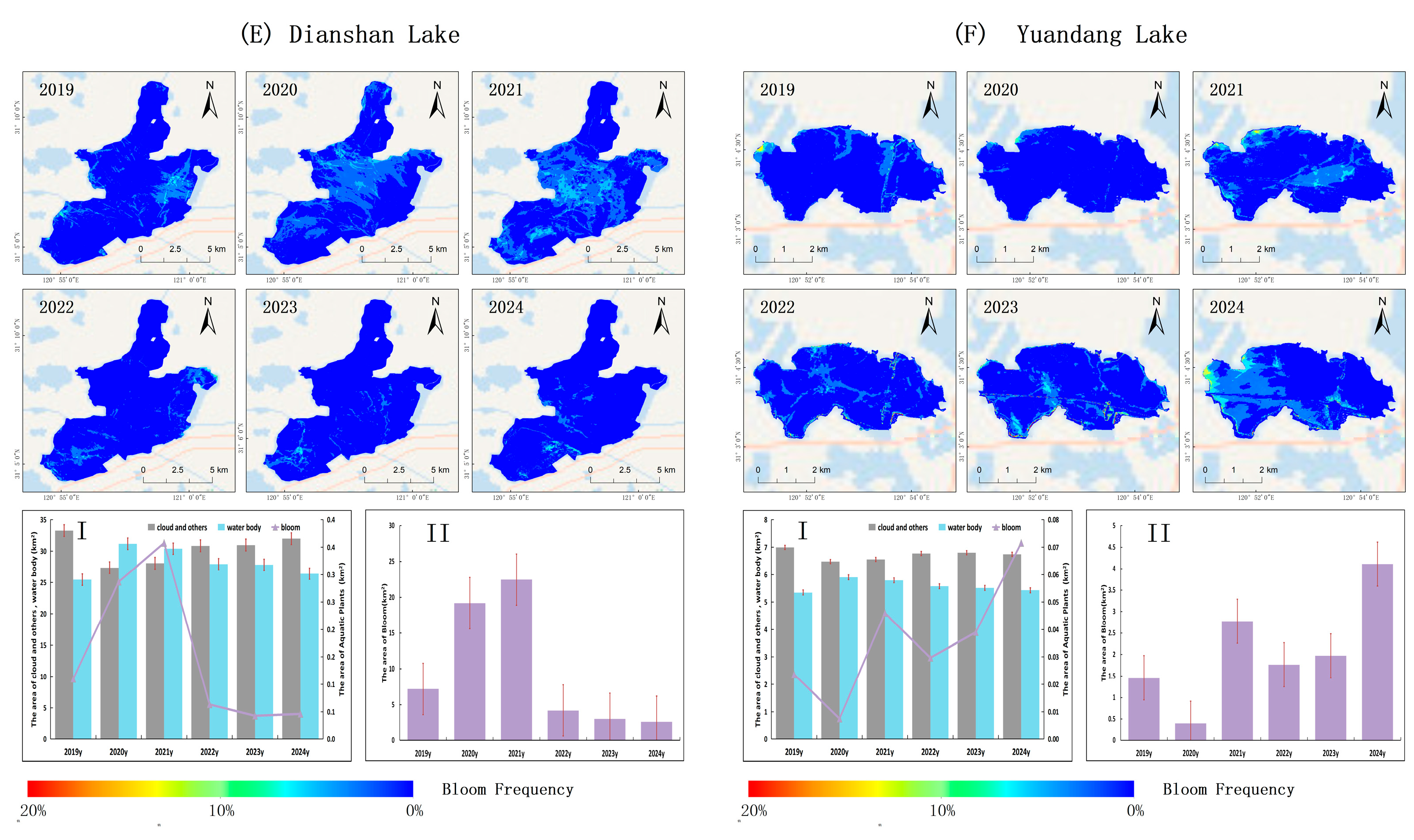
Gehu Lake showed even greater variability, with bloom-affected area peaking at 77.25 km2 in 2019, decreasing to 16.21 km2 in 2020, rising again to 66.32 km2 in 2022, falling to 4.44 km2 in 2023, and surging to 85.49 km2 in 2024. Yangcheng Lake followed a similar oscillating pattern, increasing from 1.57 km2 in 2019 to 17.43 km2 in 2020, reaching 15.55 km2 in 2022, declining to 1.59 km2 in 2023, and rebounding to 4.17 km2 in 2024. Dianshan Lake exhibited a rise-and-fall trajectory, with the affected area expanding from 7.20 km2 in 2019 to 22.48 km2 in 2021, before falling to 3.02 km2 in 2023 and 2.60 km2 in 2024.
Yuandang Lake showed a moderate increase in bloom-affected area from 1.46 km2 in 2019 to 2.78 km2 in 2021, followed by a decrease to 1.97 km2 in 2023 and a sharp rise to 4.11 km2 in 2024. Chenghu Lake recorded negligible bloom activity from 2019 to 2023 (maximum of 0.13 km2), but experienced a sudden surge to 13.50 km2 in 2024—its first large-scale bloom event in six years. Notably, both Yuandang and Chenghu lakes exhibited abrupt increases in bloom-affected area in 2024, resembling the 2022 spike observed in Changdang Lake, and may similarly be linked to hydrological disturbances induced by recent ecological restoration efforts.
In contrast, northern lakes and reservoirs exhibited generally lower bloom impact, although localized events occurred in some years. In Hongze Lake, the affected area was 14.79 km2 in 2019, dropped to 1.99 km2 in 2020, and rose to 47.28 km2 in 2024. Gaoyou and Luoma lakes recorded bloom-affected areas of 5.14 km2 and 1.30 km2, respectively, in 2023, followed by 1.42 km2 and 0.38 km2 in 2024. Shilianghe Reservoir experienced bloom activity only in 2021 (2.98 km2). No blooms were detected in Anfengshan Reservoir or Yunlong Lake during the observation period.
3.3. Spatiotemporal Dynamics of Aquatic Vegetation
Between 2018 and 2024, spatial patterns of aquatic vegetation coverage in 12 major lakes and reservoirs across Jiangsu Province revealed a pronounced north–south disparity (
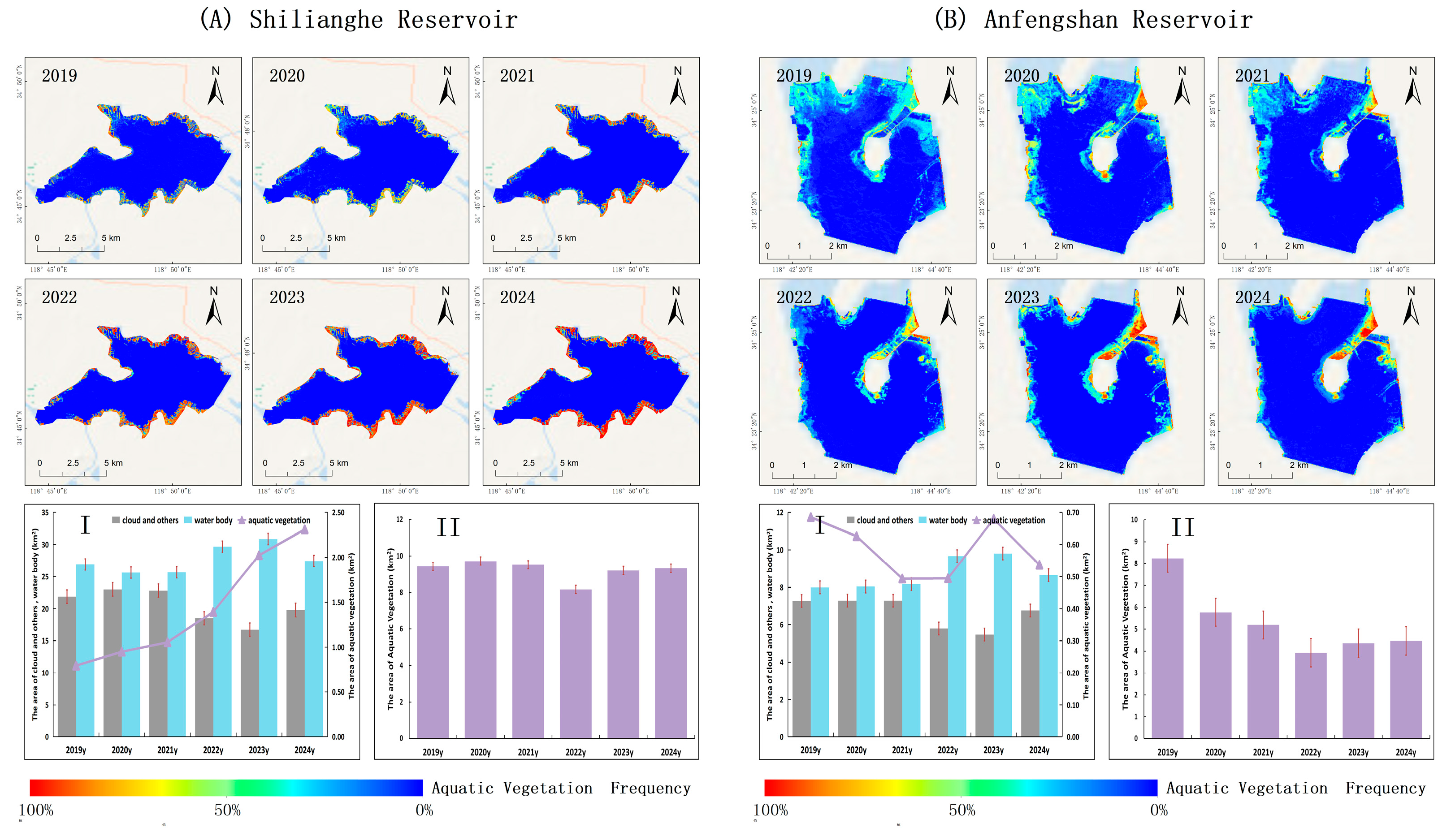
Figure 7), with higher coverage consistently observed in water bodies north of the Yangtze River. Anfengshan Reservoir (33.39%) and Gaoyou Lake (31.38%) exhibited the highest multi-year average coverage, followed by Hongze Lake (17.87%) and Shilianghe Reservoir (18.62%). In contrast, Yunlong Lake (10.08%) and Luoma Lake (6.53%) showed comparatively lower levels.
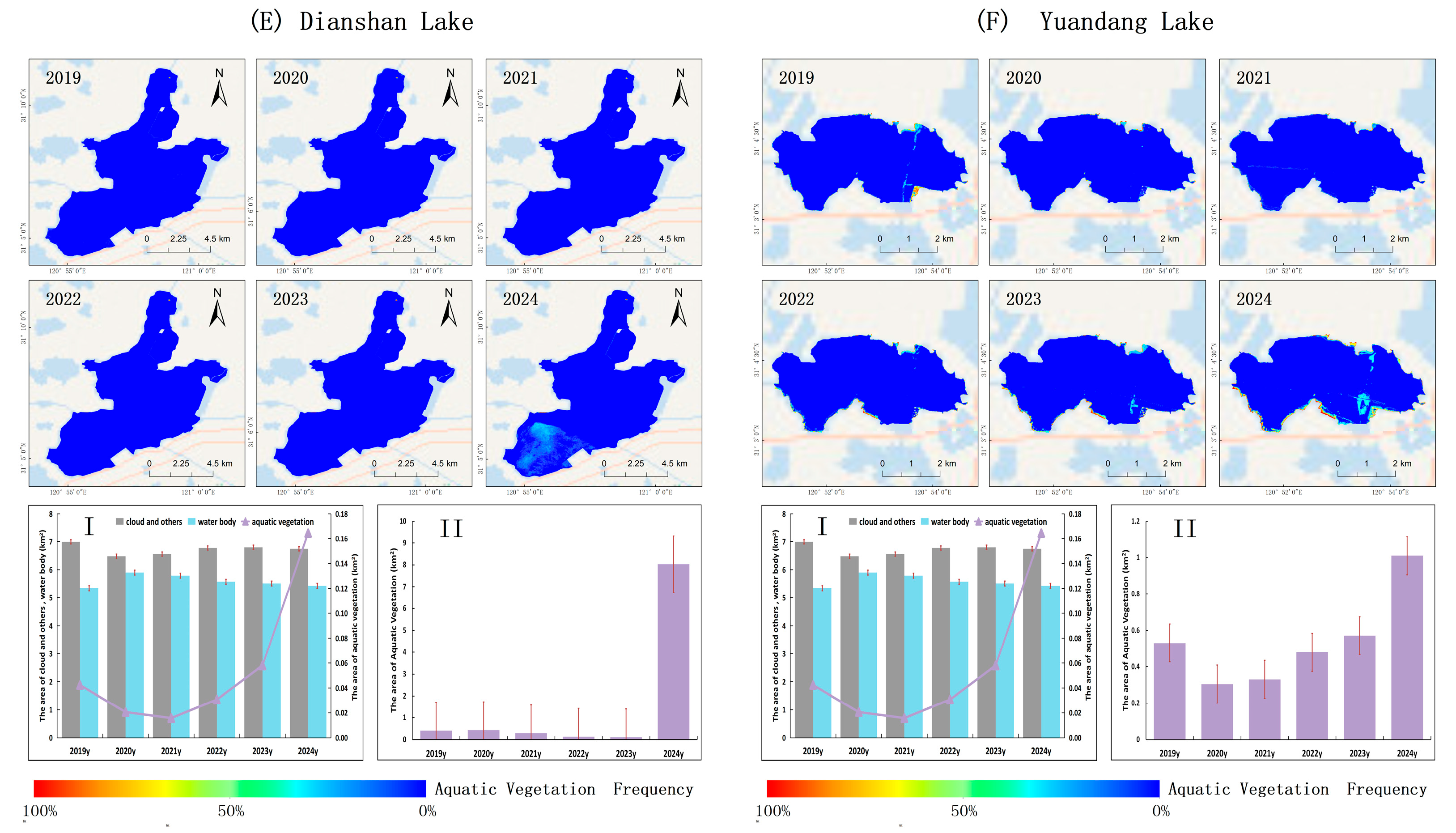
South of the Yangtze River, Yangcheng Lake (26.14%) and Changdang Lake (24.92%) displayed relatively high coverage, with a notable upward trend in Changdang Lake in recent years. Ge Lake remained consistently low (4.95%). Although Cheng Lake (1.61%), Dianshan Lake (2.67%), and Yuandang Lake (4.33%) recorded low long-term averages, all three experienced marked increases in 2024, reaching 4.35%, 13.66%, and 8.14%, respectively.
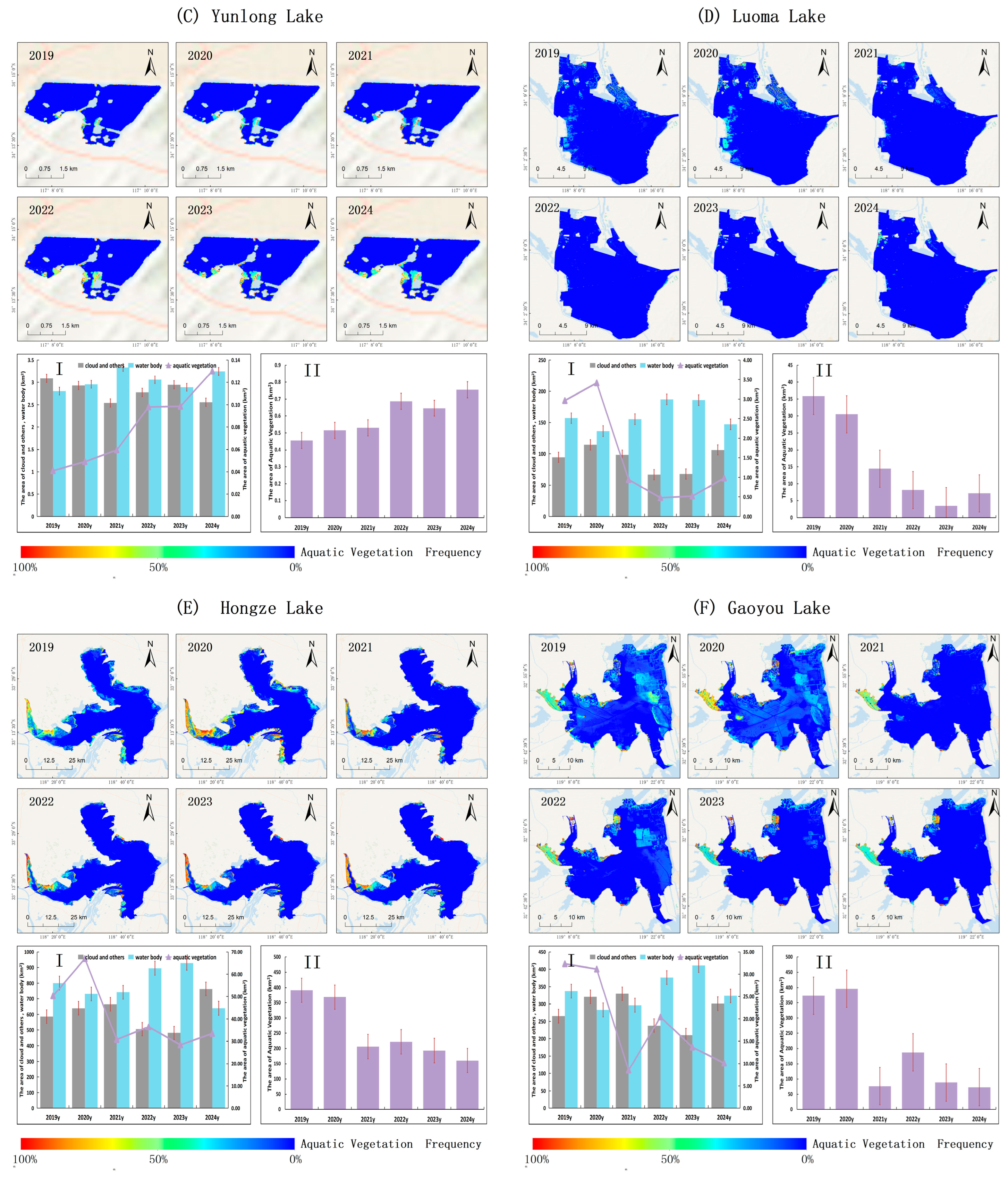
Figure 8 illustrates the frequency of aquatic vegetation occurrence from 2019 to 2024 across six major lakes and reservoirs north of the Yangtze River in Jiangsu Province. The data were derived from binarized image classification and integrated monitoring records using Equation (10). The figure also summarizes the annual mean areas of three pixel classes—cloud/other, water, and aquatic vegetation—and the interannual variability in vegetation-covered areas.
Figure 9 presents the corresponding results for six lakes located south of the Yangtze River, allowing for spatial comparisons of aquatic vegetation distribution and extent between northern and southern lake groups.
As shown in
Figure 8 and
Figure 9, aquatic vegetation coverage across twelve major lakes and reservoirs in Jiangsu Province displayed marked spatial and temporal variability between 2019 and 2024. Among the six northern water bodies (
Figure 7), Yunlong Lake exhibited a consistent increase in vegetation extent, expanding from 0.46 km
2 in 2019 to 0.75 km
2 in 2024. In contrast, Shilianghe Reservoir remained largely stable, with only minor interannual variation observed during the study period.
In contrast, Hongze Lake, Gaoyou Lake, and Anfengshan Reservoir exhibited an early expansion phase followed by a substantial decline. Hongze Lake peaked at 390.72 km2 in 2019, decreasing to 160.56 km2 by 2024, with vegetation along the eastern shoreline nearly lost. Gaoyou Lake reached 396.27 km2 in 2020, then sharply declined to 72.79 km2 in 2024, primarily due to the collapse of submerged macrophytes in the central basin. Anfengshan Reservoir declined from 8.24 km2 in 2019 to 4.47 km2 in 2024, with the northern region showing the greatest reduction. Luoma Lake recorded the most substantial loss, shrinking by nearly 80%, from 35.87 km2 in 2019 to 7.16 km2 in 2024, leaving only sparse vegetation in littoral zones.
Among the six southern lakes, Cheng Lake, Yuandang Lake, and Dianshan Lake historically exhibited low vegetation coverage (<1 km2). In 2024, all three showed marked increases, likely linked to recent ecological restoration efforts. Coverage in Cheng Lake rose to 1.77 km2, and in Yuandang Lake to 1.01 km2, both coinciding with a notable increase in cyanobacterial blooms, potentially driven by sediment disturbance and nutrient release, suggesting a short-term trade-off between vegetation recovery and bloom control. By contrast, Dianshan Lake expanded to 8.03 km2, primarily due to the proliferation of submerged vegetation in the southern basin, without a corresponding rise in bloom intensity.
Yangcheng Lake and Ge Lake followed a typical growth–decline trajectory. Yangcheng Lake peaked at 35.57 km2 in 2021 and declined to 23.51 km2 by 2023, with the central region most affected. Ge Lake showed a similar pattern, decreasing from 12.54 km2 in 2019 to 5.62 km2 in 2024, particularly in the southeastern embayments.
In contrast, Changdang Lake exhibited sustained growth throughout the study period, increasing from 16.06 km2 in 2019 to 38.68 km2 in 2024—a 140.8% increase. This long-term expansion likely reflects the success of large-scale ecological interventions, including wetland rehabilitation and aquatic vegetation reintroduction.
4. Discussion
4.1. Analysis of Extraction Accuracy Deviations for Cyanobacterial Blooms and Aquatic Vegetation
Validation results indicate that the proposed workflow achieves high accuracy in automated, integrated, and rapid monitoring. Nonetheless, several inherent sources of error persist. Cloud interference remains a primary source of deviation, particularly in pixels affected by thin cloud cover. Although these areas can be manually identified and incorporated into final cyanobacterial bloom estimates, the strict cloud-masking protocol applied in this study may exclude them, potentially leading to an underestimation of bloom extent.
Submerged macrophytes present a significant challenge due to their weak spectral signatures and high sensitivity to environmental factors such as water depth and turbidity, which hinder their detection via remote sensing. As a result, they were not separately extracted in this study, potentially leading to underestimation in areas dominated by submerged vegetation. Furthermore, validation efforts primarily targeted floating and emergent macrophytes. Given the difficulties of field verification and the low spectral contrast of submerged species in turbid waters, these plants were excluded from the validation dataset. Consequently, the reported accuracy metrics for aquatic vegetation may not fully represent the method’s performance in environments where submerged macrophytes predominate.
An additional limitation is the adjacency effect at land–water interfaces, where high reflectance from nearby terrestrial pixels can elevate near-infrared signals in adjacent water pixels. This may compromise the accuracy of vegetation indices, such as the Floating Algae Index (FAI), and lead to misclassification of nearshore waters as either cyanobacterial blooms or aquatic vegetation. The effect can extend several hundred meters from the shoreline.
This approach also has limitations when applied beyond the specific context of freshwater ecosystems. For instance, it cannot detect red tides caused by dinoflagellates in marine environments. The method is specifically designed for detecting cyanobacterial blooms in freshwater ecosystems and may therefore not be effective for monitoring other types of marine algae. Similarly, diatom blooms in certain freshwater lakes may not be accurately detected due to their distinct spectral properties compared to cyanobacteria.
Despite its limitations, the proposed method offers distinct advantages over existing approaches. By integrating temporal frequency analysis with spatial refinement techniques, it enhances the discrimination of co-occurring cyanobacterial blooms and aquatic vegetation in optically complex waters. Additionally, its implementation on the cloud-based AIE platform enables scalable and automated processing, greatly improving the efficiency and practicality of long-term monitoring at regional to continental scales. Future enhancements may involve incorporating machine learning or deep learning methods capable of leveraging multi-source data and modeling non-linear relationships to improve the detection of submerged macrophytes. For instance, models trained on multi-temporal, hyperspectral, or bathymetric datasets could increase classification accuracy in optically complex and spatially heterogeneous freshwater environments.
Finally, although Sentinel-2 MSI has lower temporal resolution compared to sensors like MODIS or the Geostationary Ocean Color Imager (GOCI), its 10-m spatial resolution provides a distinct advantage for monitoring aquatic vegetation in small- and medium-sized lakes and reservoirs.
4.2. North-South Differences in Cyanobacterial Blooms and Influencing Factors
Nutrient dynamics are widely recognized as a primary driver of cyanobacterial bloom formation due to their strong influence on algal growth and photosynthetic efficiency [
28,
29]. Nutrient limitation can constrain carbohydrate accumulation and photosynthetic output in phytoplankton, ultimately reducing biomass production and suppressing bloom development. Spatiotemporal patterns derived from satellite-based monitoring of 12 key lakes and reservoirs in Jiangsu Province (2019–2024) reveal pronounced regional differences in bloom activity, with southern water bodies generally exhibiting more frequent and intense blooms than their northern counterparts.
Several factors contribute to the elevated bloom intensity observed in southern lakes. Firstly, the warmer climate in these regions promotes conditions conducive to cyanobacterial growth. Additionally, the hydrological characteristics of southern lakes—shallower depths and more fluctuating water levels—further facilitate cyanobacterial proliferation. Moreover, anthropogenic pressures, such as intensified agricultural activity and higher population density, contribute to increased nutrient loading, exacerbating bloom formation. Lakes such as Ge Lake, Dianshan Lake, and Yuandang Lake, for instance, experience compounded nutrient inputs and heightened human activity, resulting in sustained high bloom intensity.
In contrast, lakes situated north of the Yangtze River, typically characterized by lower temperatures and more stable hydrological conditions, generally experience lower bloom intensity. However, recent climatic shifts—marked by rising temperatures and land-use changes—have led to an increase in bloom frequency and severity in some northern lakes. Notably, post-2023, Hongze Lake and Gaoyou Lake have shown an increase in bloom frequency, with Hongze Lake’s bloom coverage surging to 3.29% in 2024. These trends highlight the growing threats posed by climate change and land-use alterations, which are influencing bloom dynamics in northern lakes.
In southern lakes, socio-economic pressures, including agricultural runoff, urbanization, and intensified fishing and tourism, contribute to nutrient enrichment and higher bloom frequencies. While ecological restoration efforts have successfully promoted aquatic vegetation recovery in some lakes, they have sometimes inadvertently disturbed sediments or released nutrients, exacerbating bloom intensity. For example, Cheng Lake and Yuandang Lake both exhibited heightened bloom intensity in 2024, likely due to transient ecological imbalances induced by restoration activities such as sediment disruption or nutrient release from re-flooded zones.
Furthermore, the implementation of fishing bans in northern lakes has altered grazing pressure, affecting both aquatic vegetation growth and bloom dynamics. Lakes such as Luoma and Gaoyou have experienced long-term declines in vegetation cover, possibly linked to increased fish biomass and grazing pressure. In 2023, both lakes experienced severe cyanobacterial blooms, potentially driven by the reduction in submerged vegetation.
These findings suggest that the north-south differences in bloom intensity cannot be attributed solely to nutrient inputs and hydrological conditions, but are also influenced by climate change, socio-economic activities, and the success of ecological restoration efforts. As such, effective regional management strategies must account for these multifaceted factors to improve water quality and mitigate cyanobacterial bloom formation.
4.3. Aquatic Vegetation Dynamics and Ecological Restoration
Macrophytes are integral to maintaining the stability and resilience of lake ecosystems. Their restoration improves water transparency, reduces wind-driven disturbances, inhibits sediment resuspension, and curtails the release of internal nutrients. Additionally, they provide essential habitat and spawning grounds for zooplankton, benthic organisms, and fish populations [
30]. Modifications in fish community composition can exert top-down control within the food web, thereby limiting phytoplankton proliferation [
31]. However, an imbalance in the food web structure can compromise its regulatory capacity. For example, an increase in the biomass of fish that feed on benthic and planktonic organisms may paradoxically hinder the suppression of algal growth [
32].
Recent evidence indicates that abrupt degradation of macrophyte communities can trigger irreversible regime shifts, where cyanobacteria gain ecological dominance [
33]. Once vegetation coverage falls below a critical threshold, positive feedback mechanisms—such as light attenuation, allelopathic suppression, and trophic disruptions—can further amplify cyanobacterial proliferation, hindering macrophyte recovery. These regime shifts often follow non-linear trajectories and exhibit ecological hysteresis, making reversal particularly challenging and necessitating long-term, intensive intervention. Aquatic systems with abundant macrophyte coverage are generally more resilient to external nutrient inputs and maintain low phytoplankton biomass. In contrast, declines in vegetation cover—whether due to nutrient over-enrichment, abrupt water level fluctuations, or increased populations of benthivorous fish—can accelerate internal nitrogen and phosphorus release, stimulating phytoplankton growth and heightening the risk of cyanobacterial bloom formation.
Our findings indicate that, although aquatic vegetation cover in Cheng Lake, Dianshan Lake, and Yuandang Lake remained low in most years, all three exhibited substantial increases in 2024. These changes likely reflect regional wetland restoration initiatives or the natural expansion of submerged macrophyte communities. Shilianghe Reservoir and Yunlong Lake maintained relatively stable vegetation coverage, while Changdang Lake displayed a sustained upward trend, likely driven by ongoing inlet wetland rehabilitation efforts.
By contrast, six lakes that initially supported higher vegetation coverage exhibited progressive declines over multiple years. Notably, Gaoyou Lake, Hongze Lake, and Luoma Lake experienced persistent losses, potentially linked to increased fish biomass and heightened grazing pressure following the implementation of fishing bans, particularly impacting submerged vegetation. In 2023, both Luoma Lake and Gaoyou Lake experienced severe cyanobacterial blooms, possibly associated with reductions in aquatic vegetation abundance.
These results further emphasize the foundational role of macrophytes in maintaining the stability and resilience of lake ecosystems. Robust aquatic vegetation not only supports biodiversity and provides critical habitat but also acts as a critical barrier against cyanobacterial encroachment. Strengthening efforts to restore macrophytes and ensure long-term stewardship is essential to prevent irreversible ecological regime shifts, particularly as pressures from eutrophication and hydrological disturbances intensify. Enhancing the resilience of macrophytes provides both structural integrity and functional resistance to the initiation of blooms. By expanding vegetation coverage, ecosystems can buffer against nutrient perturbations, reduce internal nutrient mobilization, and inhibit phytoplankton overgrowth—thereby mitigating the risk of cyanobacterial dominance and preserving ecological equilibrium.
4.4. Future Outlook
This study provides a preliminary assessment of the spatiotemporal dynamics of cyanobacterial blooms and aquatic vegetation across 12 key lakes and reservoirs in Jiangsu Province. It explores the potential roles of meteorological conditions, nutrient loading, and biological factors in driving their expansion and decline. Given the relatively short observation period, the underlying ecological mechanisms remain only partially understood. Sustained long-term monitoring is therefore essential to identify the primary drivers of these dynamics.
To support automated, standardized, and efficient monitoring, we developed an intelligent detection and assessment system based on Sentinel-2 MSI data, deployed on the AIE platform (
http://www.zgwxsj.com:8509 (accessed on 3 July 2025)). The system supports real-time updates, historical data archiving, and information sharing, offering robust technical support for dynamic lake monitoring and integrated ecological assessment. Its implementation aims to inform evidence-based management and targeted intervention for cyanobacterial bloom control and aquatic vegetation regulation.
In line with enhancing management strategies, future ecological management should prioritize the development of more efficient and timely early warning systems for cyanobacterial blooms. Currently, satellite data processing via cloud-based platforms is subject to a delay of approximately 10 h. To improve the timeliness of bloom forecasts, we propose the implementation of a localized automated processing system utilizing API-based satellite data downloads. By processing data locally, response times could be reduced to 1–2 h, facilitating more rapid and precise early warnings. This would enable stakeholders to take swift, informed actions to mitigate the impact of blooms.
Furthermore, sediment resuspension and its link to the emergence of cyanobacteria were not explicitly addressed in the present remote sensing framework, but these processes hold significant ecological relevance. Disturbance of benthic sediments can increase turbidity, mobilizing cyanobacterial propagules into the water column, potentially initiating surface bloom formation. Recognizing this pathway as a critical precursor to bloom events, future research should incorporate sediment–water interactions to improve detection accuracy and predictive capacity.
For further enhancement of bloom monitoring and prediction, future research should focus on improving the integration of multi-source data. Combining satellite imagery, water quality sensors, meteorological data, and other environmental variables will offer a more comprehensive understanding of the factors driving bloom dynamics. Developing advanced algorithms, such as machine learning models, can optimize the integration of these datasets, increasing prediction accuracy. Additionally, refining detection algorithms for smaller-scale blooms and distinguishing between different cyanobacterial species could lead to more precise and tailored management strategies.
On the ecological management front, we recommend advancing integrated watershed-scale strategies, including pollution source control, ecological dredging, and wetland restoration. Accelerated remediation of inflowing river channels, improved governance, and enhanced regulatory oversight are also critical. Adopting a macro-ecological perspective is necessary to systematically investigate the long-term evolution of lake–reservoir ecosystems. This includes elucidating the interactions among algal communities, aquatic vegetation, zooplankton, benthic fauna, and water quality, and identifying the key processes and drivers involved. Particular attention should be given to the role of food web structure and trophic cascades in bloom regulation, and to evaluating the ecological impacts of fishery bans. These insights will provide a scientific foundation for more effective and adaptive lake ecosystem management strategies.
5. Conclusions
This study introduces the development of an automated system for identifying cyanobacterial blooms and aquatic vegetation in small- and medium-sized lakes. The system is based on phenological principles and utilizes Sentinel-2 MSI satellite imagery via the AIE platform developed by Alibaba DAMO Academy. It was applied to assess the spatiotemporal dynamics of 12 key lakes and reservoirs in Jiangsu Province, all of which are susceptible to cyanobacterial bloom events. The study also evaluated potential sources of classification errors. These include limited detectability of submerged vegetation, adjacency effects causing nearshore pixel misclassification, and cloud interference affecting image accuracy. Despite these challenges, the system demonstrated robust performance and broad applicability.
The results reveal significant regional variations in bloom activity coverage. Lakes south of the Yangtze River consistently exhibited higher bloom frequency and intensity, particularly in Ge Lake, Dianshan Lake, and Yuandang Lake, with average bloom coverage from 2019 to 2025 of 33.7%, 16.6%, and 16.8%, respectively. In contrast, bloom activity in Changdang Lake and Yangcheng Lake has notably declined in recent years, suggesting that ongoing nutrient reduction and water quality improvement efforts are yielding positive results. Notably, in 2024, bloom frequency in Cheng Lake and Yuandang Lake sharply increased, with Cheng Lake’s bloom coverage rising from 0.3% in 2019 to 33.2%, and Yuandang Lake’s increasing from 11.8% to 33.1%. These increases may be linked to short-term ecological disturbances during wetland restoration, such as sediment disturbance or nutrient release, emphasizing the need to monitor potential unintended consequences during ecological rehabilitation. Northern lakes exhibited low bloom risk throughout the study period, with no significant bloom events recorded in Shilianghe Reservoir, Anfengshan Reservoir, or Yunlong Lake. However, since 2023, bloom intensity has increased in Hongze Lake, Gaoyou Lake, and Luoma Lake, particularly in Hongze Lake, where bloom coverage rose from 1.0% in 2019 to 3.3% in 2024. This trend suggests emerging ecosystem instability, highlighting the urgent need for proactive and targeted management measures.
Aquatic vegetation patterns exhibited distinct heterogeneous trends. In 2024, significant increases in vegetation coverage were observed in Cheng Lake, Dianshan Lake, and Yuandang Lake, with increases of 3.2%, 13.0%, and 3.5%, respectively, compared to 2023. These lakes, historically characterized by low vegetation abundance, may have experienced this increase due to ecological restoration efforts or the natural expansion of submerged macrophytes. Conversely, the vegetation coverage in Shilianghe Reservoir and Yunlong Lake remained stable. Cheng Lake, however, showed a continuous upward trend under ongoing wetland rehabilitation, with coverage rising from 18.5% in 2019 to 44.6% in 2024. Meanwhile, six lakes that had historically supported higher vegetation coverage experienced a persistent decline, particularly in Gaoyou Lake, Luoma Lake, and Hongze Lake, where coverage decreased by 11.28%, 16.02%, and 47.32%, respectively, from 2019 to 2024. These declines are likely associated with increased fish biomass and intensified grazing pressure following fishing bans, which may have reduced the suppressive effect of aquatic vegetation on cyanobacterial blooms.
In conclusion, this study provides a detailed analysis of the spatiotemporal dynamics and ecological drivers of cyanobacterial blooms and aquatic vegetation in major lakes and reservoirs across Jiangsu Province. The remote sensing monitoring system developed herein represents a significant advancement in aquatic ecosystem observation and water quality management. By incorporating state-of-the-art remote sensing technologies, the system offers a robust, standardized, and scalable solution for long-term ecological assessment. Its modular design and cloud-based deployment further enhance its adaptability for use in other eutrophication-affected lake regions. Nonetheless, the detection of submerged macrophytes remains a limitation due to their weak spectral signals and the complexity of aquatic environments. Improving detection accuracy will require higher-frequency satellite observations, the integration of machine learning techniques, and enhanced ground-truth validation.
This system not only enables accurate tracking of key ecological indicators but also facilitates the development of evidence-based strategies for ecosystem restoration and adaptive lake management. Looking forward, the integration of satellite data with in-situ water quality measurements, sediment dynamics, and biological interactions will be crucial for enhancing the predictive power and ecological relevance of monitoring frameworks. Overall, the findings of this study provide valuable insights and establish a transferable technical foundation for the future protection and sustainable management of freshwater ecosystems.


