
Scalable Hyperspectral Enhancement via Patch-Wise Sparse Residual Learning: Insights from Super-Resolved EnMAP Data


Abstract

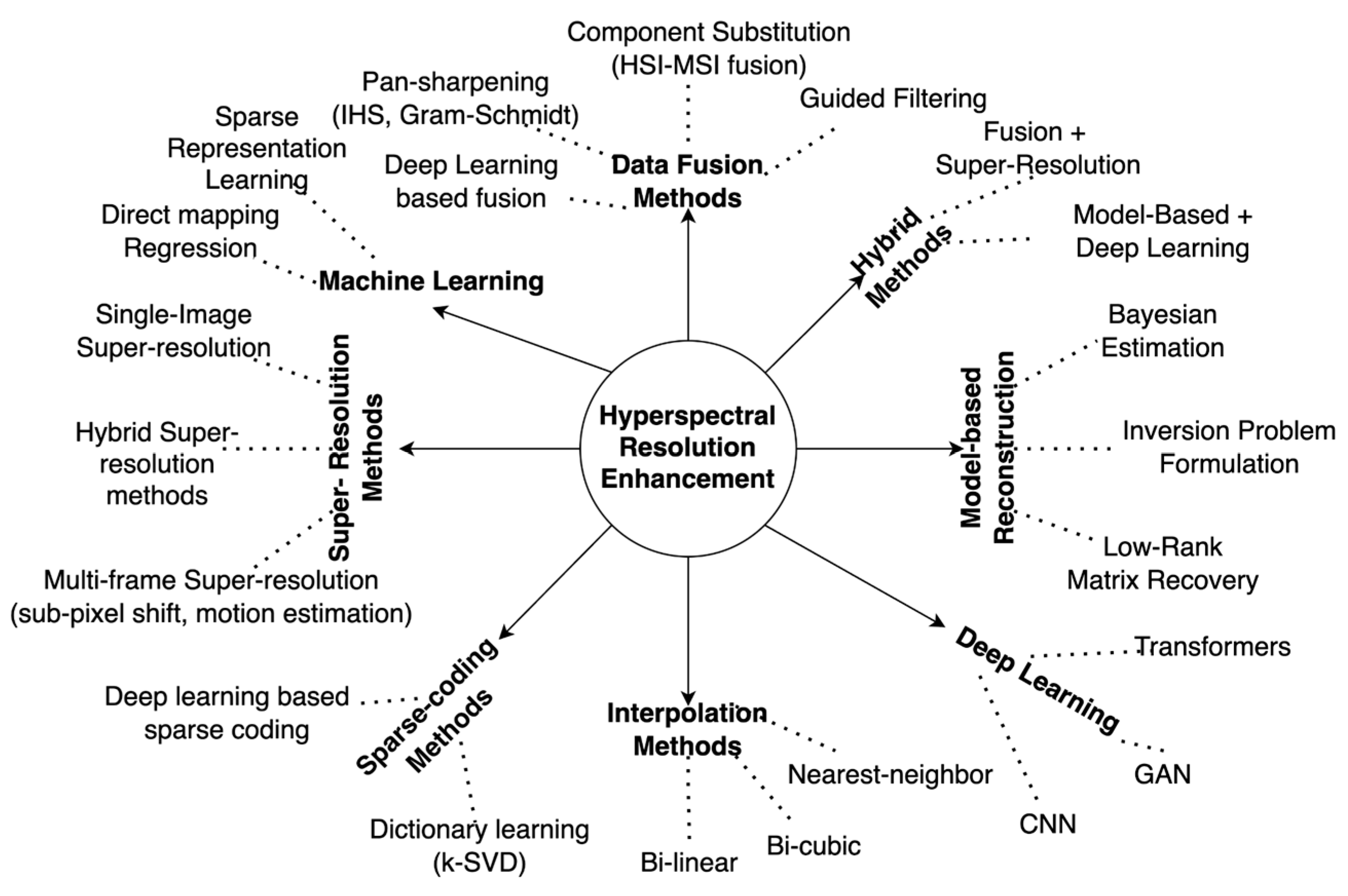
1. Introduction
2. Study Areas and Dataset Description
2.1. Study Areas
2.2. Multi-Modal Benchmark Dataset
2.3. Satellite and Airborne Remote Sensing Datasets for the Test Sites
3. Proposed Method and Experimental Setup
3.1. Parallel Patch-Wise Sparse Residual Learning (P2SR) Method
3.2. Experimental Setup and Evaluation Strategies
4. Results
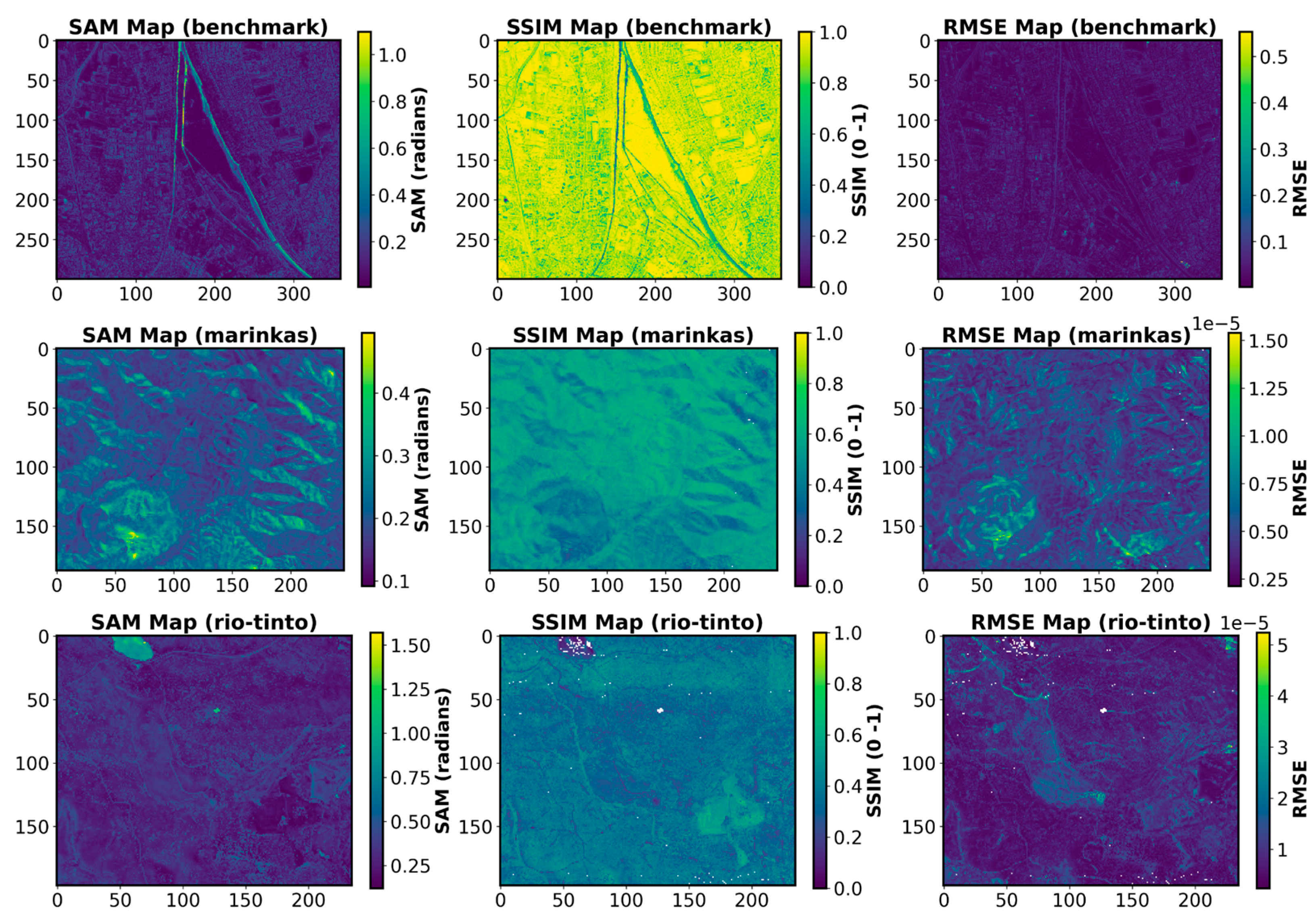
4.1. Metrics-Based Assessment of Enhanced Hyperspectral Products
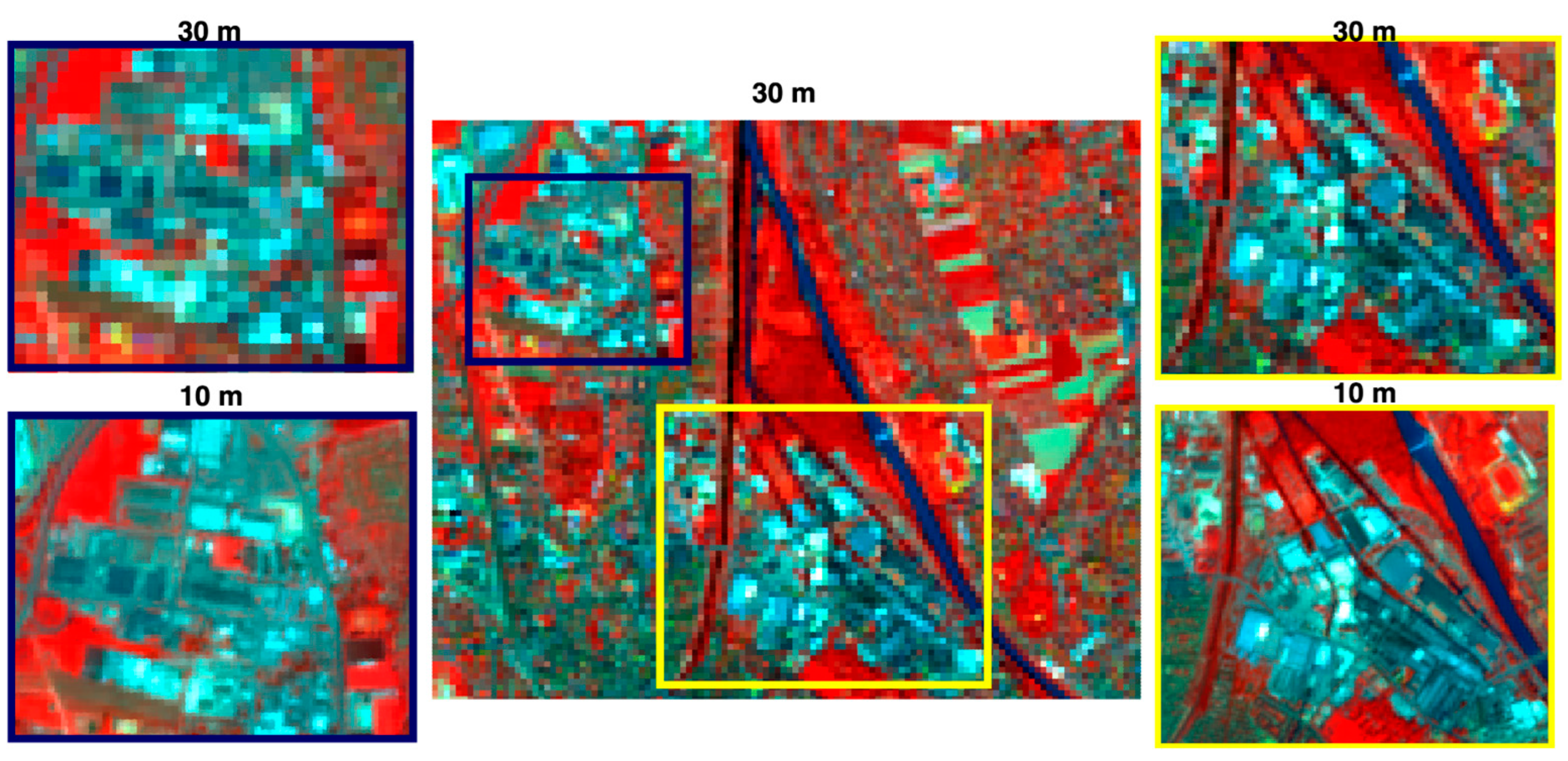
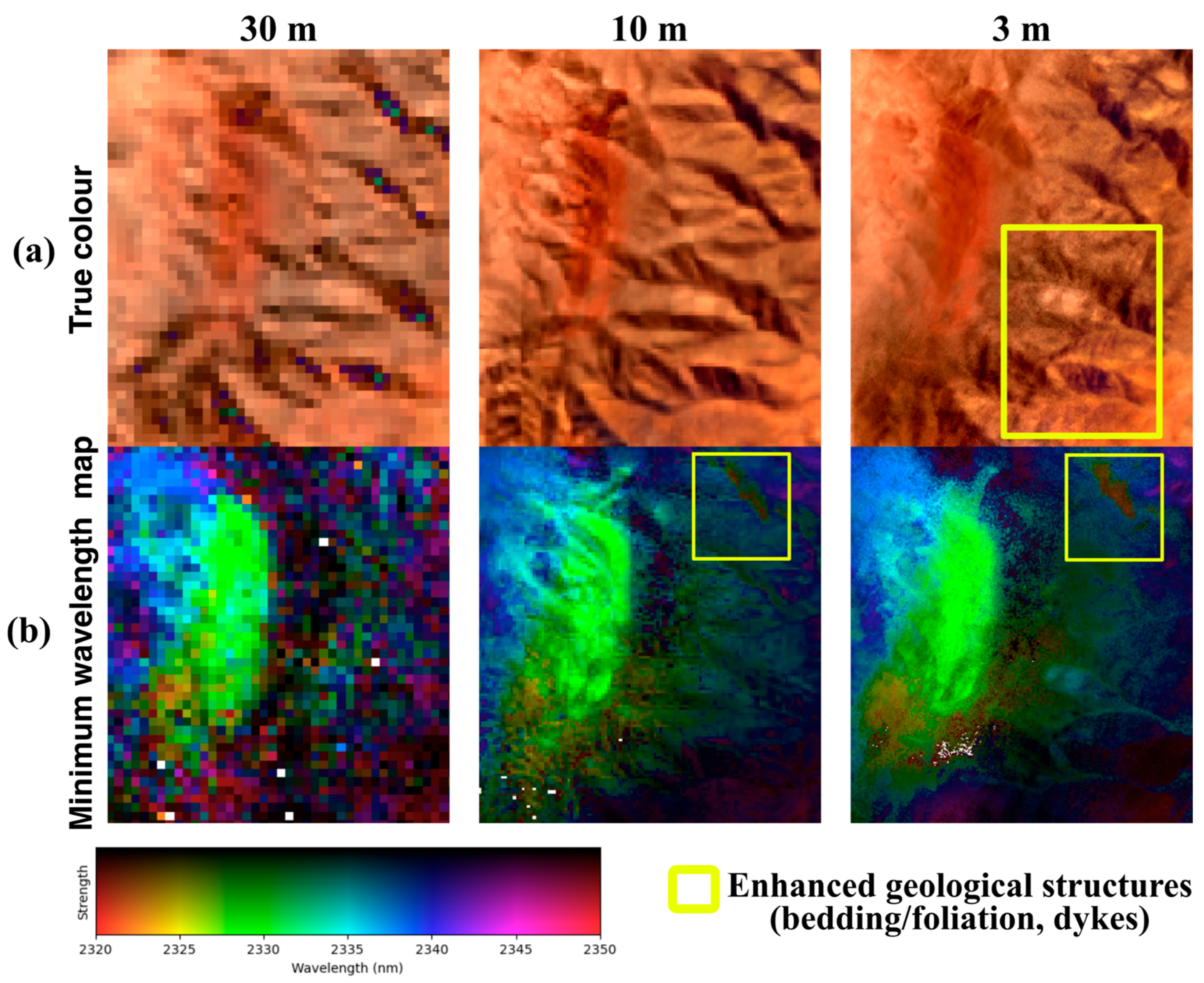
4.2. Qualitative Spatial Assessment of Enhanced Hyperspectral Products
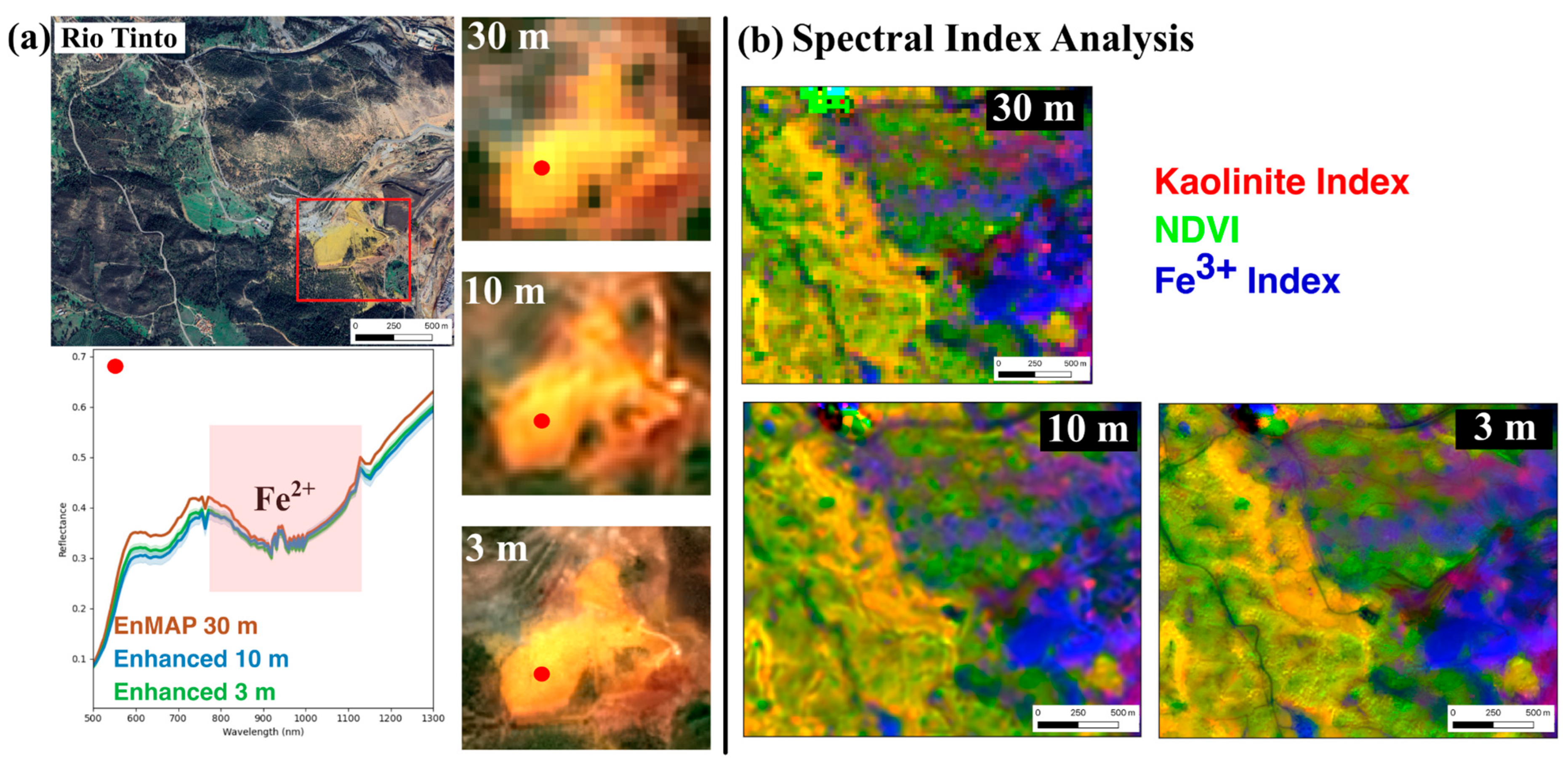
4.3. Application-Oriented Assessment of Enhanced HSI Products
5. Discussion
5.1. Significant Contributions to Hyperspectral Resolution Enhancement
5.2. Comparative Analysis with Deep Learning Based Approaches
5.3. Limitations and Future Scope
6. Conclusions
Author Contributions
Funding
Data Availability Statement
Acknowledgments
Conflicts of Interest
Appendix A
| Algorithm A1 For parallel patchwise spare residual learning method (P2SR) |
| 1. Input: : Multispectral data, , : Hyperspectral data, 2. Pre-processing: Normalize each band to [0, 1] Set Set If 3. Patch Processing: Compute Scaling factor f = Downsample MSI by factor f, = zoom(, f) :
Sparse Coding using FISTA with ‘’ regularization Given a dictionary , use FISTA iterations to minimize
|
| 5. Selection of MSI-guide bands and injection of high-frequency details Select three suitable MSI-guide bands: Extract high-frequency details: Inject high-frequency details: For each band 6. Guided Filtering with MSI-guide bands ) 7. Output: Enhanced Hyperspectral, |
References
- Zhukov, B.; Oertel, D.; Lanzl, F.; Reinhackel, G. Unmixing-Based Multisensor Multiresolution Image Fusion. IEEE Trans. Geosci. Remote Sens. 1999, 37, 1212–1226. [Google Scholar] [CrossRef]
- Eismann, M.T.; Hardie, R.C. Application of the Stochastic Mixing Model to Hyperspectral Resolution Enhancement. IEEE Trans. Geosci. Remote Sens. 2004, 42, 1924–1933. [Google Scholar] [CrossRef]
- Shah, V.P.; Younan, N.H.; King, R.L. An Efficient Pan-Sharpening Method via a Combined Adaptive PCA Approach and Contourlets. IEEE Trans. Geosci. Remote Sens. 2008, 46, 1323–1335. [Google Scholar] [CrossRef]
- Jelének, J.; Kopačková, V.; Koucká, L.; Mišurec, J. Testing a Modified PCA-Based Sharpening Approach for Image Fusion. Remote Sens. 2016, 8, 794. [Google Scholar] [CrossRef]
- Dalla Mura, M.; Vivone, G.; Restaino, R.; Addesso, P.; Chanussot, J. Global and Local Gram-Schmidt Methods for Hyperspectral Pansharpening. In Proceedings of the 2015 IEEE International Geoscience and Remote Sensing Symposium (IGARSS), Milan, Italy, 26–31 July 2015. [Google Scholar] [CrossRef]
- Qu, J.; Li, Y.; Dong, W. A New Hyperspectral Pansharpening Method Based on Guided Filter. In Proceedings of the 2017 IEEE International Geoscience and Remote Sensing Symposium (IGARSS), Fort Worth, TX, USA, 23–28 July 2017; pp. 5125–5128. [Google Scholar] [CrossRef]
- Dong, W.; Xiao, S.; Li, Y. Hyperspectral Pansharpening Based on Guided Filter and Gaussian Filter. J. Vis. Commun. Image Represent. 2018, 53, 171–179. [Google Scholar] [CrossRef]
- Yokoya, N.; Yairi, T.; Iwasaki, A. Coupled Nonnegative Matrix Factorization Unmixing for Hyperspectral and Multispectral Data Fusion. IEEE Trans. Geosci. Remote Sens. 2012, 50, 528–537. [Google Scholar] [CrossRef]
- Simoes, M.; Bioucas-Dias, J.; Almeida, L.B.; Chanussot, J. A Convex Formulation for Hyperspectral Image Superresolution via Subspace-Based Regularization. IEEE Trans. Geosci. Remote Sens. 2015, 53, 3373–3388. [Google Scholar] [CrossRef]
- Irmak, H.; Akar, G.B.; Yuksel, S.E. A MAP-Based Approach for Hyperspectral Imagery Super-Resolution. IEEE Trans. Image Process. 2018, 27, 2942–2951. [Google Scholar] [CrossRef]
- Irmak, H.; Akar, G.B.; Yuksel, S.E.; Aytaylan, H. Super-Resolution Reconstruction of Hyperspectral Images via an Improved MAP-Based Approach. In Proceedings of the 2016 IEEE International Geoscience and Remote Sensing Symposium (IGARSS), Beijing, China, 10–15 July 2016; pp. 7244–7247. [Google Scholar] [CrossRef]
- Akgun, T.; Altunbasak, Y.; Mersereau, R.M. Super-Resolution Reconstruction of Hyperspectral Images. IEEE Trans. Image Process. 2005, 14, 1860–1875. [Google Scholar] [CrossRef]
- Zhang, H.; Zhang, L.; Shen, H. A Super-Resolution Reconstruction Algorithm for Hyperspectral Images. Signal Process. 2012, 92, 2082–2096. [Google Scholar] [CrossRef]
- Huang, H.; Christodoulou, A.G.; Sun, W. Super-Resolution Hyperspectral Imaging with Unknown Blurring by Low-Rank and Group-Sparse Modeling. In Proceedings of the 2014 IEEE International Conference on Image Processing (ICIP), Paris, France, 27–30 October 2014; pp. 2155–2159. [Google Scholar] [CrossRef]
- Xu, X.; Tong, X.; Li, J.; Xie, H.; Zhong, Y.; Zhang, L.; Song, D. Hyperspectral Image Super Resolution Reconstruction with a Joint Spectral-Spatial Sub-Pixel Mapping Model. In Proceedings of the 2016 IEEE International Geoscience and Remote Sensing Symposium (IGARSS), Beijing, China, 10–15 July 2016; pp. 6129–6132. [Google Scholar] [CrossRef]
- He, S.; Zhou, H.; Wang, Y.; Cao, W.; Han, Z. Super-Resolution Reconstruction of Hyperspectral Images via Low Rank Tensor Modeling and Total Variation Regularization. In Proceedings of the 2016 IEEE International Geoscience and Remote Sensing Symposium (IGARSS), Beijing, China, 10–15 July 2016; pp. 6962–6965. [Google Scholar] [CrossRef]
- Wang, L.; Bi, T.; Shi, Y. A Frequency-Separated 3D-CNN for Hyperspectral Image Super-Resolution. IEEE Access 2020, 8, 86367–86379. [Google Scholar] [CrossRef]
- Ma, X.; Hong, Y.; Song, Y.; Chen, Y. A Super-Resolution Convolutional-Neural-Network-Based Approach for Subpixel Mapping of Hyperspectral Images. IEEE J. Sel. Top. Appl. Earth Obs. Remote Sens. 2019, 12, 4930–4939. [Google Scholar] [CrossRef]
- Liu, W.; Lee, J. An Efficient Residual Learning Neural Network for Hyperspectral Image Superresolution. IEEE J. Sel. Top. Appl. Earth Obs. Remote Sens. 2019, 12, 1240–1253. [Google Scholar] [CrossRef]
- Wang, C.; Liu, Y.; Bai, X.; Tang, W.; Lei, P.; Zhou, J. Deep Residual Convolutional Neural Network for Hyperspectral Image Super-Resolution. In Image and Graphics, Proceedings of the 9th International Conference, ICIG 2017, Shanghai, China, 13–15 September 2017; Lecture Notes in Computer Science; Springer: Berlin/Heidelberg, Germany, 2017; pp. 370–380. [Google Scholar] [CrossRef]
- Zhu, Z.; Hou, J.; Chen, J.; Zeng, H.; Zhou, J. Hyperspectral Image Super-Resolution via Deep Progressive Zero-Centric Residual Learning. IEEE Trans. Image Process. 2021, 30, 1423–1438. [Google Scholar] [CrossRef] [PubMed]
- Wang, B.; Zhang, S.; Feng, Y.; Mei, S.; Jia, S.; Du, Q. Hyperspectral Imagery Spatial Super-Resolution Using Generative Adversarial Network. IEEE Trans. Comput. Imaging 2021, 7, 948–960. [Google Scholar] [CrossRef]
- Wang, J.; Zhu, X.; Jing, L.; Tang, Y.; Li, H.; Xiao, Z.; Ding, H. HyperGAN: A Hyperspectral Image Fusion Approach Based on Generative Adversarial Networks. Remote Sens. 2024, 16, 4389. [Google Scholar] [CrossRef]
- Hu, J.; Liu, Y.; Kang, X.; Fan, S. Multilevel Progressive Network with Nonlocal Channel Attention for Hyperspectral Image Super-Resolution. IEEE Trans. Geosci. Remote Sens. 2022, 60, 5543714. [Google Scholar] [CrossRef]
- Hu, J.-F.; Huang, T.-Z.; Deng, L.-J.; Jiang, T.-X.; Vivone, G.; Chanussot, J. Hyperspectral Image Super-Resolution via Deep Spatiospectral Attention Convolutional Neural Networks. IEEE Trans. Neural Netw. Learn. Syst. 2022, 33, 7251–7265. [Google Scholar] [CrossRef]
- Zhang, M.; Zhang, C.; Zhang, Q.; Guo, J.; Gao, X.; Zhang, J. ESSAformer: Efficient Transformer for Hyperspectral Image Super-Resolution. In Proceedings of the 2023 IEEE/CVF International Conference on Computer Vision (ICCV), Paris, France, 2–3 October 2023; pp. 23016–23027. [Google Scholar] [CrossRef]
- Liu, Y.; Hu, J.; Kang, X.; Luo, J.; Fan, S. Interactformer: Interactive Transformer and CNN for Hyperspectral Image Super-Resolution. IEEE Trans. Geosci. Remote Sens. 2022, 60, 5531715. [Google Scholar] [CrossRef]
- Gao, L.; Li, J.; Zheng, K.; Jia, X. Enhanced Autoencoders with Attention-Embedded Degradation Learning for Unsupervised Hyperspectral Image Super-Resolution. IEEE Trans. Geosci. Remote Sens. 2023, 61, 5509417. [Google Scholar] [CrossRef]
- Fang, Y.; Liu, Y.; Chi, C.-Y.; Long, Z.; Zhu, C. CS2DIPs: Unsupervised HSI Super-Resolution Using Coupled Spatial and Spectral DIPs. IEEE Trans. Image Process. 2024, 33, 3090–3101. [Google Scholar] [CrossRef] [PubMed]
- Jia, S.; Zhu, S.; Wang, Z.; Xu, M.; Wang, W.; Guo, Y. Diffused Convolutional Neural Network for Hyperspectral Image Super-Resolution. IEEE Trans. Geosci. Remote Sens. 2023, 61, 5504615. [Google Scholar] [CrossRef]
- Li, S.; Tian, Y.; Wang, C.; Wu, H.; Zheng, S. Hyperspectral Image Super-Resolution Network Based on Cross-Scale Nonlocal Attention. IEEE Trans. Geosci. Remote Sens. 2023, 61, 5509615. [Google Scholar] [CrossRef]
- Bieniarz, J.; Cerra, D.; Avbelj, J.; Reinartz, P.; Müller, R. Hyperspectral Image Resolution Enhancement Based On Spectral Unmixing and Information Fusion. Int. Arch. Photogramm. Remote Sens. Spat. Inf. Sci. 2012, XXXVIII–4/W19, 33–37. [Google Scholar] [CrossRef]
- Li, L.; He, H.; Chen, N.; Kang, X.; Wang, B. SLRCNN: Integrating Sparse and Low-Rank with a CNN Denoiser for Hyperspectral and Multispectral Image Fusion. Int. J. Appl. Earth Obs. Geoinf. 2024, 134, 104227. [Google Scholar] [CrossRef]
- Liu, X.; Liu, Q.; Wang, Y. Remote Sensing Image Fusion Based on Two-Stream Fusion Network. Inf. Fusion 2020, 55, 1–15. [Google Scholar] [CrossRef]
- Xiao, J.; Li, J.; Yuan, Q.; Jiang, M.; Zhang, L. Physics-Based GAN With Iterative Refinement Unit for Hyperspectral and Multispectral Image Fusion. IEEE J. Sel. Top. Appl. Earth Obs. Remote Sens. 2021, 14, 6827–6841. [Google Scholar] [CrossRef]
- Booysen, R.; Jackisch, R.; Lorenz, S.; Zimmermann, R.; Kirsch, M.; Nex, P.A.; Gloaguen, R. Detection of REEs with lightweight UAV-based hyperspectral imaging. Sci. Rep. 2020, 10, 17450. [Google Scholar] [CrossRef]
- Thiele, S.T.; Lorenz, S.; Kirsch, M.; Acosta, I.C.C.; Tusa, L.; Herrmann, E.; Möckel, R.; Gloaguen, R. Multi-scale, multi-sensor data integration for automated 3-D geological mapping. Ore Geol. Rev. 2021, 136, 104252. [Google Scholar] [CrossRef]
- Smithies, R.H.; Marsh, J.S. The Marinkas Quellen Carbonatite Complex, southern Namibia; carbonatite magmatism with an uncontaminated depleted mantle signature in a continental setting. Chem. Geol. 1998, 148, 201–212. [Google Scholar] [CrossRef]
- Salkield, L.U. A Technical History of the Rio Tinto Mines: Some Notes on Exploitation from Pre-Phoenician Times to the 1950s; Cahalan, M.J., Ed.; Springer: Dordrecht, The Netherlands, 1987. [Google Scholar] [CrossRef]
- Hu, J.; Liu, R.; Hong, D.; Camero, A.; Yao, J.; Schneider, M.; Kurz, F.; Segl, K.; Zhu, X.X. MDAS: A New Multimodal Benchmark Dataset for Remote Sensing. Earth Syst. Sci. Data 2023, 15, 113–131. [Google Scholar] [CrossRef]
- Mairal, J.; Ponce, J.; Sapiro, G.; Zisserman, A.; Bach, F. Supervised Dictionary Learning. In Advances in Neural Information Processing Systems; Koller, D., Schuurmans, D., Bengio, Y., Bottou, L., Eds.; MIT Press: Cambridge, MA, USA, 2008; Volume 21. [Google Scholar]
- Beck, A.; Teboulle, M. A Fast Iterative Shrinkage-Thresholding Algorithm for Linear Inverse Problems. SIAM J. Imaging Sci. 2009, 2, 183–202. [Google Scholar] [CrossRef]
- Zhang, X.; Huang, W.; Wang, Q.; Li, X. SSR-NET: Spatial–Spectral Reconstruction Network for Hyperspectral and Multispectral Image Fusion. IEEE Trans. Geosci. Remote Sens. 2021, 59, 5953–5965. [Google Scholar] [CrossRef]
- Chakraborty, R.; Thiele, S.; Naik, P.; Gloaguen, R. Evaluation of Spectral and Spatial Reconstruction in Resolution-Enhanced Hyperspectral Data for Effective Mineral Mapping. In Proceedings of the IGARSS 2025—2025 IEEE International Geoscience and Remote Sensing Symposium, Brisbane, Australia, 3–8 August 2025. [Google Scholar] [CrossRef]
- Liu, Z.; Wang, W.; Ma, Q.; Liu, X.; Jiang, J. Rethinking 3D-CNN in Hyperspectral Image Super-Resolution. Remote Sens. 2023, 15, 2574. [Google Scholar] [CrossRef]
- Fu, Y.; Liang, Z.; You, S. Bidirectional 3D Quasi-Recurrent Neural Network for Hyperspectral Image Super-Resolution. IEEE J. Sel. Top. Appl. Earth Obs. Remote Sens. 2021, 14, 2674–2688. [Google Scholar] [CrossRef]
- Wu, H.; Wang, C.; Lu, C.; Zhan, T. HCT: A Hybrid CNN and Transformer Network for Hyperspectral Image Super-Resolution. Multimed. Syst. 2024, 30, 185. [Google Scholar] [CrossRef]
- Fotiadou, K.; Tsagkatakis, G.; Tsakalides, P. Spectral Super Resolution of Hyperspectral Images via Coupled Dictionary Learning. IEEE Trans. Geosci. Remote Sens. 2019, 57, 2777–2797. [Google Scholar] [CrossRef]
- Li, J.; Yuan, Q.; Shen, H.; Meng, X.; Zhang, L. Hyperspectral Image Super-Resolution by Spectral Mixture Analysis and Spatial–Spectral Group Sparsity. IEEE Geosci. Remote Sens. Lett. 2016, 13, 1250–1254. [Google Scholar] [CrossRef]
- PV, A.; Krishna Mohan, B.; Porwal, A. Spatial-Spectral Feature Based Approach towards Convolutional Sparse Coding of Hyperspectral Images. Comput. Vis. Image Underst. 2019, 188, 102797. [Google Scholar] [CrossRef]
- Chiang, C.-K.; Su, T.-F.; Yen, C.; Lai, S.-H. Multi-Attributed Dictionary Learning for Sparse Coding. In Proceedings of the 2013 IEEE International Conference on Computer Vision, Sydney, Australia, 1–8 December 2013; pp. 1137–1144. [Google Scholar] [CrossRef]
- Planet Team. Planet Application Program Interface: In Space for Life on Earth. San Francisco, CA, USA. 2025. Available online: https://api.planet.com (accessed on 24 January 2025).


| Datasets | Area of Acquisition | Spatial Resolution (m) | Spectral Range (nm) | No. of Spectral Bands |
|---|---|---|---|---|
| HySpex (airborne HSI) | Benchmark, Rio-Tinto | 2 | 416–2498 | 416 |
| HyMap (airborne HSI) | Marinkas | 5 | 450–2480 | 125 |
| EnMAP (satellite HSI) | All sites * | 30 | 418–2445 | 224 |
| Sentinel-2 (satellite MSI) | All sites | 10 | 442–2202 | 10 |
| PlanetScope (satellite MSI) | Marinkas, Rio-Tinto | 3 | 431–885 | 8 |
| Methods | Dataset | PSNR ↑ | SAM ↓ | ERGAS ↓ | Q2n ↑ |
|---|---|---|---|---|---|
| Bicubic | Benchmark | 27.5781 | 7.8388 | 8.0238 | 0.5161 |
| Marinkas | 18.6866 | 16.2178 | 9.0665 | 0.4973 | |
| Rio-Tinto | 27.6162 | 19.7070 | 12.0446 | 0.4168 | |
| Average | 24.6269 | 14.5878 | 9.7116 | 0.4767 | |
| c-Hysure | Benchmark | 16.5403 | 61.1513 | 28.3078 | 0.3218 |
| Marinkas | 9.9804 | 16.1053 | 18.5097 | 0.4786 | |
| Rio-Tinto | 19.3073 | 74.2513 | 27.3184 | 0.2615 | |
| Average | 15.2760 | 50.5026 | 24.7119 | 0.3539 | |
| CNMF | Benchmark | 28.4535 | 7.3729 | 7.3467 | 0.6561 |
| Marinkas | 17.4397 | 27.8083 | 27.8083 | 0.2932 | |
| Rio-Tinto | 26.8105 | 23.1117 | 21.7775 | 0.1504 | |
| Average | 24.2345 | 19.4309 | 18.9775 | 0.3665 | |
| ResTFNet | Benchmark | 16.3690 | 18.9499 | 27.8768 | 0.5499 |
| Marinkas | 8.9582 | 12.3331 | 25.5877 | 0.3832 | |
| Rio-Tinto | 23.9273 | 18.3529 | 15.6876 | 0.3935 | |
| Average | 16.4181 | 16.5453 | 23.0507 | 0.4422 | |
| SSR-NET | Benchmark | 16.3689 | 21.8292 | 27.8770 | 0.3946 |
| Marinkas | 8.9345 | 13.5766 | 25.4453 | 0.3681 | |
| Rio-Tinto | 25.2540 | 22.1869 | 14.8889 | 0.4647 | |
| Average | 16.8524 | 19.1974 | 22.7370 | 0.4091 | |
| P2SR (proposed) | Benchmark | 28.7581 | 7.1787 | 6.9932 | 0.6670 |
| Marinkas | 19.3302 | 12.1016 | 8.0017 | 0.5151 | |
| Rio-Tinto | 27.5418 | 18.0825 | 11.7936 | 0.3649 | |
| Average | 25.2100 | 12.4542 | 8.9295 | 0.5156 |
Disclaimer/Publisher’s Note: The statements, opinions and data contained in all publications are solely those of the individual author(s) and contributor(s) and not of MDPI and/or the editor(s). MDPI and/or the editor(s) disclaim responsibility for any injury to people or property resulting from any ideas, methods, instructions or products referred to in the content. |
© 2025 by the authors. Licensee MDPI, Basel, Switzerland. This article is an open access article distributed under the terms and conditions of the Creative Commons Attribution (CC BY) license (https://creativecommons.org/licenses/by/4.0/).
Share and Cite
Naik, P.; Chakraborty, R.; Thiele, S.; Gloaguen, R. Scalable Hyperspectral Enhancement via Patch-Wise Sparse Residual Learning: Insights from Super-Resolved EnMAP Data. Remote Sens. 2025, 17, 1878. https://doi.org/10.3390/rs17111878
Naik P, Chakraborty R, Thiele S, Gloaguen R. Scalable Hyperspectral Enhancement via Patch-Wise Sparse Residual Learning: Insights from Super-Resolved EnMAP Data. Remote Sensing. 2025; 17(11):1878. https://doi.org/10.3390/rs17111878
Chicago/Turabian StyleNaik, Parth, Rupsa Chakraborty, Sam Thiele, and Richard Gloaguen. 2025. "Scalable Hyperspectral Enhancement via Patch-Wise Sparse Residual Learning: Insights from Super-Resolved EnMAP Data" Remote Sensing 17, no. 11: 1878. https://doi.org/10.3390/rs17111878
APA StyleNaik, P., Chakraborty, R., Thiele, S., & Gloaguen, R. (2025). Scalable Hyperspectral Enhancement via Patch-Wise Sparse Residual Learning: Insights from Super-Resolved EnMAP Data. Remote Sensing, 17(11), 1878. https://doi.org/10.3390/rs17111878