Spatial Prediction of Soil Texture in Low-Relief Agricultural Areas Using Rice and Wheat Growth Information with Spatiotemporal Stability
Abstract
1. Introduction
2. Materials and Methods
2.1. Study Area
2.2. Data Collection and Analysis
2.3. Methodology
2.4. Spatiotemporal Stable Peak (SSP) Maps Generations
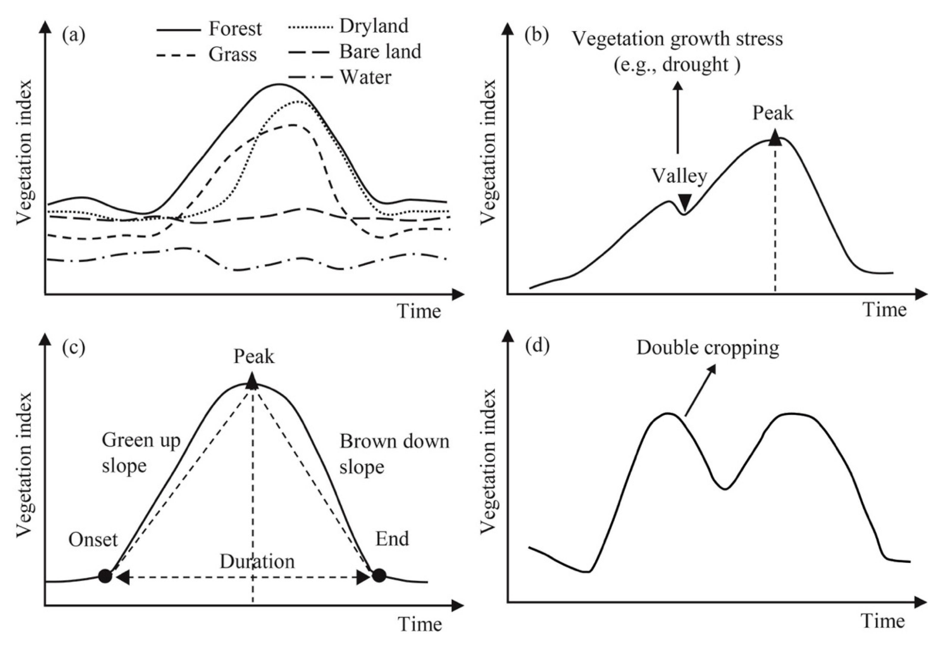
2.4.1. Estimation of the Peak Values in an RVI Time-Series Curve
2.4.2. Selection for the Peak Maps with Similarity
2.4.3. Filling of Missing Pixels in Peak Maps
2.4.4. Abnormal Pixels Removals in Peak Maps
2.5. Soil Texture Prediction and Accuracy Assessment
3. Results
3.1. Statistical Soil Texture Characteristics
3.2. SSP Maps Characteristics
3.3. Relationship Between SSP and Soil Texture
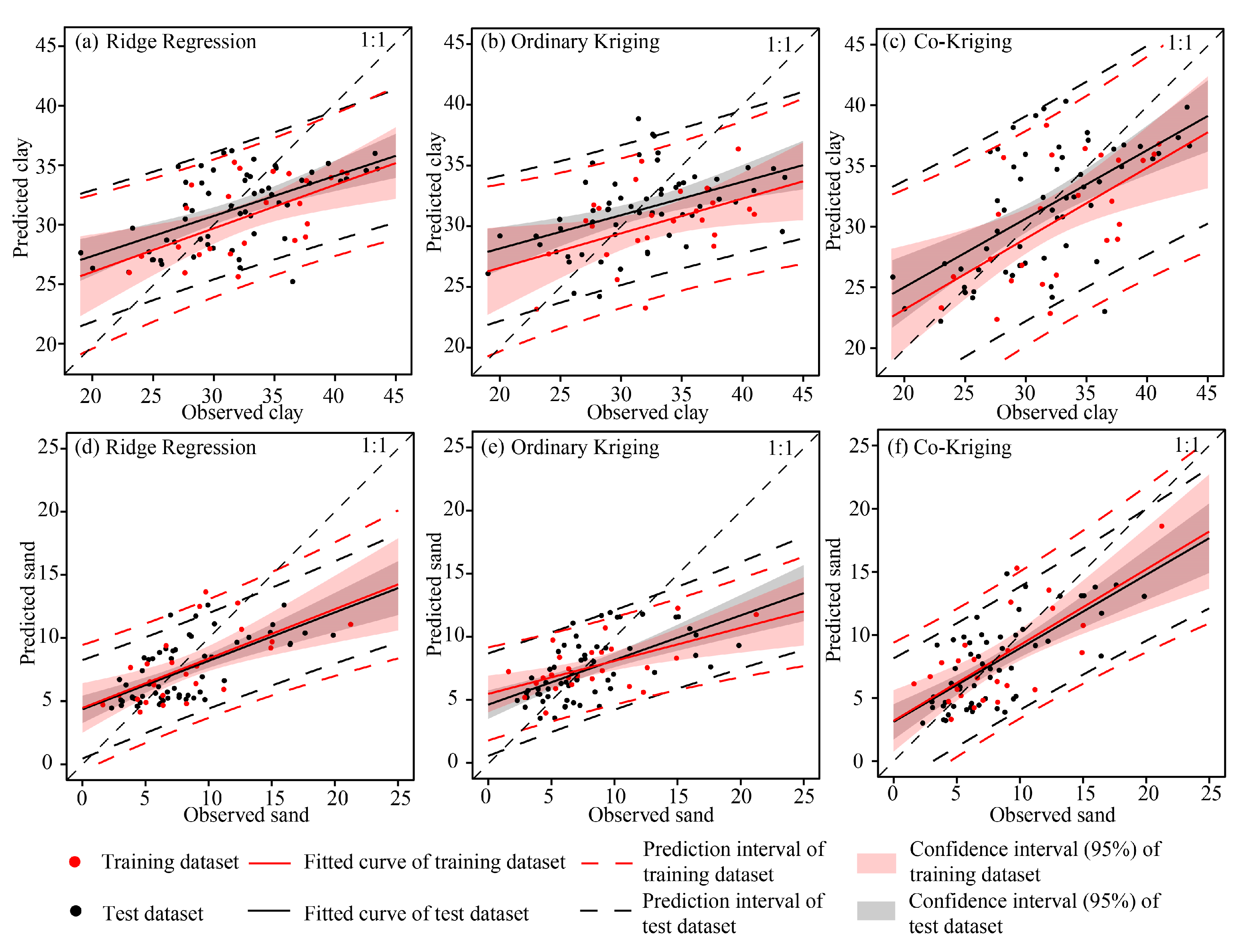
3.4. Soil Texture Prediction Results
4. Discussion
4.1. Model Performance
4.2. Comparison of SSP with Vegetation Variables
4.3. SSP Applicability and Limitations in Predicting Soil Texture
5. Conclusions
Author Contributions
Funding
Data Availability Statement
Acknowledgments
Conflicts of Interest
References
- Chen, X.; Zhang, X.; Wei, Y.; Zhang, S.; Cai, C.; Guo, Z.; Wang, J. Assessment of soil quality in a heavily fragmented micro-landscape induced by gully erosion. Geoderma 2023, 431, 116369. [Google Scholar] [CrossRef]
- Cimusa Kulimushi, L.; Bigabwa Bashagaluke, J.; Prasad, P.; Heri-Kazi, A.B.; Lal Kushwaha, N.; Masroor, M.; Choudhari, P.; Elbeltagi, A.; Sajjad, H.; Mohammed, S. Soil erosion susceptibility mapping using ensemble machine learning models: A case study of upper Congo river sub-basin. CATENA 2023, 222, 106858. [Google Scholar] [CrossRef]
- McBratney, A.B.; Mendonça Santos, M.L.; Minasny, B. On digital soil mapping. Geoderma 2003, 117, 3–52. [Google Scholar] [CrossRef]
- Minasny, B.; McBratney, A.B. Digital soil mapping: A brief history and some lessons. Geoderma 2016, 264, 301–311. [Google Scholar] [CrossRef]
- Ma, Y.; Minasny, B.; Malone, B.P.; McBratney, A.B. Pedology and digital soil mapping (DSM). Eur. J. Soil Sci. 2019, 70, 216–235. [Google Scholar] [CrossRef]
- Zhu, A.X.; Liu, F.; Li, B.; Pei, T.; Qin, C.; Liu, G.; Wang, Y.; Chen, Y.; Ma, X.; Qi, F.; et al. Differentiation of Soil Conditions over Low Relief Areas Using Feedback Dynamic Patterns. Soil Sci. Soc. Am. J. 2010, 74, 861–869. [Google Scholar] [CrossRef]
- Pahlavan-Rad, M.R.; Akbarimoghaddam, A. Spatial variability of soil texture fractions and pH in a flood plain (case study from eastern Iran). CATENA 2018, 160, 275–281. [Google Scholar] [CrossRef]
- Kaya, F.; Başayiğit, L.; Keshavarzi, A.; Francaviglia, R. Digital mapping for soil texture class prediction in northwestern Türkiye by different machine learning algorithms. Geoderma Reg. 2022, 31, e00584. [Google Scholar] [CrossRef]
- Wälder, K.; Wälder, O.; Rinklebe, J.; Menz, J. Estimation of soil properties with geostatistical methods in floodplains. Arch. Agron. Soil Sci. 2008, 54, 275–295. [Google Scholar] [CrossRef]
- Delbari, M.; Afrasiab, P.; Loiskandl, W. Geostatistical analysis of soil texture fractions on the field scale. Soil Water Res. 2011, 6, 173–189. [Google Scholar] [CrossRef]
- Reza, S.K.; Nayak, D.C.; Chattopadhyay, T.; Mukhopadhyay, S.; Singh, S.K.; Srinivasan, R. Spatial distribution of soil physical properties of alluvial soils: A geostatistical approach. Arch. Agron. Soil Sci. 2015, 62, 972–981. [Google Scholar] [CrossRef]
- Li, J.; Wan, H.; Shang, S. Comparison of interpolation methods for mapping layered soil particle-size fractions and texture in an arid oasis. Catena 2020, 190, 104514. [Google Scholar] [CrossRef]
- Mulder, V.L.; de Bruin, S.; Schaepman, M.E.; Mayr, T.R. The use of remote sensing in soil and terrain mapping-A review. Geoderma 2011, 162, 1–19. [Google Scholar] [CrossRef]
- Castaldi, F.; Palombo, A.; Santini, F.; Pascucci, S.; Pignatti, S.; Casa, R. Evaluation of the potential of the current and forthcoming multispectral and hyperspectral imagers to estimate soil texture and organic carbon. Remote Sens. Environ. 2016, 179, 54–65. [Google Scholar] [CrossRef]
- Zhang, G.L.; Liu, F.; Song, X.D. Recent progress and future prospect of digital soil mapping: A review. J. Integr. Agric. 2017, 16, 2871–2885. [Google Scholar] [CrossRef]
- Mgohele, R.N.; Massawe, B.H.J.; Shitindi, M.J.; Sanga, H.G.; Omar, M.M. Prediction of soil texture using remote sensing data. A systematic review. Front. Remote Sens. 2024, 5, 1461537. [Google Scholar] [CrossRef]
- Odeh, I.; McBratney, A.B. Using AVHRR Images for Spatial Prediction of Clay Content in the Lower Namoi Valley of eastern Australia. Geoderma 2000, 97, 237–254. [Google Scholar] [CrossRef]
- Chagas, C.d.S.; de Carvalho Junior, W.; Bhering, S.B.; Calderano Filho, B. Spatial prediction of soil surface texture in a semiarid region using random forest and multiple linear regressions. CATENA 2016, 139, 232–240. [Google Scholar] [CrossRef]
- Shahriari, M.; Delbari, M.; Afrasiab, P.; Pahlavan-Rad, M.R. Predicting regional spatial distribution of soil texture in floodplains using remote sensing data: A case of southeastern Iran. CATENA 2019, 182, 104149. [Google Scholar] [CrossRef]
- Swain, S.R.; Chakraborty, P.; Panigrahi, N.; Vasava, H.B.; Reddy, N.N.; Roy, S.; Majeed, I.; Das, B.S. Estimation of soil texture using Sentinel-2 multispectral imaging data: An ensemble modeling approach. Soil Tillage Res. 2021, 213, 105134. [Google Scholar] [CrossRef]
- Lagacherie, P.; Baret, F.; Feret, J.B.; Madeira Netto, J.; Robbez-Masson, J.M. Estimation of soil clay and calcium carbonate using laboratory, field and airborne hyperspectral measurements. Remote Sens. Environ. 2008, 112, 825–835. [Google Scholar] [CrossRef]
- Castaldi, F.; Casa, R.; Castrignanò, A.; Pascucci, S.; Palombo, A.; Pignatti, S. Estimation of soil properties at the field scale from satellite data: A comparison between spatial and non-spatial techniques. Eur. J. Soil Sci. 2014, 65, 842–851. [Google Scholar] [CrossRef]
- Zribi, M.; Kotti, F.; Lili-Chabaane, Z.; Baghdadi, N.; Issa, N.B.; Amri, R.; Amri, B.; Chehbouni, A. Soil Texture Estimation Over a Semiarid Area Using TerraSAR-X Radar Data. IEEE Geosci. Remote Sens. Lett. 2012, 9, 353–357. [Google Scholar] [CrossRef]
- Niang, M.A.; Nolin, M.C.; Jego, G.; Perron, I. Digital Mapping of Soil Texture Using RADARSAT-2 Polarimetric Synthetic Aperture Radar Data. Soil Sci. Soc. Am. J. 2014, 78, 673–684. [Google Scholar] [CrossRef]
- Benedet, L.; Faria, W.M.; Silva, S.H.G.; Mancini, M.; Demattê, J.A.M.; Guilherme, L.R.G.; Curi, N. Soil texture prediction using portable X-ray fluorescence spectrometry and visible near-infrared diffuse reflectance spectroscopy. Geoderma 2020, 376, 114553. [Google Scholar] [CrossRef]
- Bellinaso, H.; Silvero, N.E.Q.; Ruiz, L.F.C.; Accorsi Amorim, M.T.; Rosin, N.A.; Mendes, W.d.S.; Sousa, G.P.B.d.; Sepulveda, L.M.A.; Queiroz, L.G.d.; Nanni, M.R.; et al. Clay content prediction using spectra data collected from the ground to space platforms in a smallholder tropical area. Geoderma 2021, 399, 115116. [Google Scholar] [CrossRef]
- Andrade, R.; Mancini, M.; Teixeira, A.F.d.S.; Silva, S.H.G.; Weindorf, D.C.; Chakraborty, S.; Guilherme, L.R.G.; Curi, N. Proximal sensor data fusion and auxiliary information for tropical soil property prediction: Soil texture. Geoderma 2022, 422, 115936. [Google Scholar] [CrossRef]
- Naimi, S.; Ayoubi, S.; Di Raimo, L.A.D.L.; Dematte, J.A.M. Quantification of some intrinsic soil properties using proximal sensing in arid lands: Application of Vis-NIR, MIR, and pXRF spectroscopy. Geoderma Reg. 2022, 28, e00484. [Google Scholar] [CrossRef]
- Chang, D.H.; Kothari, R.; Islam, S. Classification of soil texture using remotely sensed brightness temperature over the Southern Great Plains. IEEE Trans. Geosci. Remote Sens. 2003, 41, 664–674. [Google Scholar] [CrossRef]
- Liu, F.; Zhu, A.X.; Li, B.L.; Pei, T.; Qin, C.Z.; Liu, G.H.; Wang, Y.J.; Zhou, C.H. Identification of spatial difference of soil types using land surface feedbacks dynamic patterns. Chin. J. Soil Sci. 2009, 40, 501–508. (In Chinese) [Google Scholar]
- Liu, F.; Geng, X.; Zhu, A.X.; Fraser, W.; Waddell, A. Soil texture mapping over low relief areas using land surface feedback dynamic patterns extracted from MODIS. Geoderma 2012, 171, 44–52. [Google Scholar] [CrossRef]
- Zeng, C.; Zhu, A.X.; Liu, F.; Yang, L.; Rossiter, D.G.; Liu, J.; Wang, D. The impact of rainfall magnitude on the performance of digital soil mapping over low-relief areas using a land surface dynamic feedback method. Ecol. Indic. 2017, 72, 297–309. [Google Scholar] [CrossRef]
- Wang, D.C.; Zhang, G.L.; Pan, X.Z.; Zhao, Y.G.; Zhao, M.S.; Wang, G.F. Mapping Soil Texture of a Plain Area Using Fuzzy-c-Means Clustering Method Based on Land Surface Diurnal Temperature Difference. Pedosphere 2012, 22, 394–403. [Google Scholar] [CrossRef]
- Liu, F.; Rossiter, D.G.; Song, X.D.; Zhang, G.L.; Wu, H.; Zhao, Y. An approach for broad-scale predictive soil properties mapping in low-relief areas based on responses to solar radiation. Soil Sci. Soc. Am. J. 2020, 84, 144–162. [Google Scholar] [CrossRef]
- Ben-Dor, E. Quantitative remote sensing of soil properties. Adv. Agron. 2002, 75, 173–243. [Google Scholar]
- Timsina, J.; Connor, D.J. Productivity and management of rice–wheat cropping systems: Issues and challenges. Field Crops Res. 2001, 69, 93–132. [Google Scholar] [CrossRef]
- Guo, L.; Fu, P.; Shi, T.; Chen, Y.; Zhang, H.; Meng, R.; Wang, S. Mapping field-scale soil organic carbon with unmanned aircraft system-acquired time series multispectral images. Soil Tillage Res. 2020, 196, 104477. [Google Scholar] [CrossRef]
- Guo, L.; Sun, X.; Fu, P.; Shi, T.; Dang, L.; Chen, Y.; Linderman, M.; Zhang, G.; Zhang, Y.; Jiang, Q. Mapping soil organic carbon stock by hyperspectral and time-series multispectral remote sensing images in low-relief agricultural areas. Geoderma 2021, 398, 115118. [Google Scholar] [CrossRef]
- Zhang, Y.; Guo, L.; Chen, Y.; Shi, T.; Luo, M.; Ju, Q.; Zhang, H.; Wang, S. Prediction of soil organic carbon based on Landsat 8 monthly NDVI data for the Jianghan Plain in Hubei Province, China. Remote Sens. 2019, 11, 1683. [Google Scholar] [CrossRef]
- Sainju, U.M.; Senwo, Z.N.; Nyakatawa, E.Z.; Tazisong, I.A.; Reddy, K.C. Soil carbon and nitrogen sequestration as affected by long-term tillage, cropping systems, and nitrogen fertilizer sources. Agric. Ecosyst. Environ. 2008, 127, 234–240. [Google Scholar] [CrossRef]
- Sombrero, A.; de Benito, A. Carbon accumulation in soil. Ten-year study of conservation tillage and crop rotation in a semi-arid area of Castile-Leon, Spain. Soil Tillage Res. 2010, 107, 64–70. [Google Scholar] [CrossRef]
- Tong, X.; Xu, M.; Wang, X.; Bhattacharyya, R.; Zhang, W.; Cong, R. Long-term fertilization effects on organic carbon fractions in a red soil of China. CATENA 2014, 113, 251–259. [Google Scholar] [CrossRef]
- Xu, J.; Han, H.; Ning, T.; Li, Z.; Lal, R. Long-term effects of tillage and straw management on soil organic carbon, crop yield, and yield stability in a wheat-maize system. Field Crops Res. 2019, 233, 33–40. [Google Scholar] [CrossRef]
- Yuan, G.; Huan, W.; Song, H.; Lu, D.; Chen, X.; Wang, H.; Zhou, J. Effects of straw incorporation and potassium fertilizer on crop yields, soil organic carbon, and active carbon in the rice–wheat system. Soil Tillage Res. 2021, 209, 104958. [Google Scholar] [CrossRef]
- Dong, L.; Wang, H.; Shen, Y.; Wang, L.; Zhang, H.; Shi, L.; Lu, C.; Shen, M. Straw type and returning amount affects SOC fractions and Fe/Al oxides in a rice-wheat rotation system. Appl. Soil Ecol. 2023, 183, 104736. [Google Scholar] [CrossRef]
- Yang, L.; Song, M.; Zhu, A.X.; Qin, C.; Zhou, C.; Qi, F.; Li, X.; Chen, Z.; Gao, B. Predicting soil organic carbon content in croplands using crop rotation and Fourier transform decomposed variables. Geoderma 2019, 340, 289–302. [Google Scholar] [CrossRef]
- Yang, L.; He, X.; Shen, F.; Zhou, C.; Zhu, A.X.; Gao, B.; Chen, Z.; Li, M. Improving prediction of soil organic carbon content in croplands using phenological parameters extracted from NDVI time series data. Soil Tillage Res. 2020, 196, 104465. [Google Scholar] [CrossRef]
- He, X.; Yang, L.; Li, A.; Zhang, L.; Shen, F.; Cai, Y.; Zhou, C. Soil organic carbon prediction using phenological parameters and remote sensing variables generated from Sentinel-2 images. CATENA 2021, 205, 105442. [Google Scholar] [CrossRef]
- Wu, Z.; Liu, Y.; Han, Y.; Zhou, J.; Liu, J.; Wu, J. Mapping farmland soil organic carbon density in plains with combined cropping system extracted from NDVI time-series data. Sci. Total Environ. 2021, 754, 142120. [Google Scholar] [CrossRef]
- Huang, C.Y. Soil Science; Higher Education Press: Beijing, China, 2000. [Google Scholar]
- Cao, W.X.; He, J.S.; Ding, Y.F. Crop Science; Higher Education Press: Beijing, China, 2001. [Google Scholar]
- Blume, H.P.; Brümmer, G.W.; Fleige, H.; Horn, R.; Kandeler, E.; Kögel-Knabner, I.; Kretzschmar, R.; Stahr, K.; Wilke, B.M. Soil-Plant Relations. In Scheffer/Schachtschabel Soil Science; Springer: Berlin/Heidelberg, Germany, 2016; pp. 409–484. [Google Scholar]
- Barbosa, L.C.; Souza, Z.M.d.; Franco, H.C.J.; Otto, R.; Rossi Neto, J.; Garside, A.L.; Carvalho, J.L.N. Soil texture affects root penetration in Oxisols under sugarcane in Brazil. Geoderma Reg. 2018, 13, 15–25. [Google Scholar] [CrossRef]
- Chinese National Soil Survey Office. Chinese Soil Taxonomy System; Chinese National Soil Survey Office: Beijing, China, 1992.
- FAO; ISRIC; ISSS. World Reference Base for Soil Resources. In World Soil Resources Reports; FAO: Rome, Italy, 1998; p. 84. [Google Scholar]
- Zhang, G.L.; Gong, Z.T. Soil Survey Laboratory Methods; Science Press: Beijing, China, 2012. [Google Scholar]
- Tucker, C.J. Red and photographic infrared linear combinations for monitoring vegetation. Remote Sens. Environ. 1979, 8, 127–150. [Google Scholar] [CrossRef]
- Gu, Y.; Wylie, B.K.; Howard, D.M.; Phuyal, K.P.; Ji, L. NDVI saturation adjustment: A new approach for improving cropland performance estimates in the Greater Platte River Basin, USA. Ecol. Indic. 2013, 30, 1–6. [Google Scholar] [CrossRef]
- Nielsen, D.R.; Bouma, J. Soil Spatial Variability; Center Agricultural Pub & Document: Wageningen, The Netherlands, 1985; p. 174. [Google Scholar]
- Weil, R.; Brady, N. The Nature and Properties of Soils, 15th ed.; Pearson Press: London, UK, 2017; pp. 152–158. [Google Scholar]
- Webster, R.; Oliver, M. Geostatistics for Environmental Scientists, 2nd ed.; John Wiley and Sons: Chichester, UK, 2007. [Google Scholar]
- Li, J.; Heap, A.D. A review of comparative studies of spatial interpolation methods in environmental sciences: Performance and impact factors. Ecol. Inform. 2011, 6, 228–241. [Google Scholar] [CrossRef]
- Li, J.; Heap, A.D. Spatial interpolation methods applied in the environmental sciences: A review. Environ. Model. Softw. 2014, 53, 173–189. [Google Scholar] [CrossRef]
- Grunwald, S. Multi-criteria characterization of recent digital soil mapping and modeling approaches. Geoderma 2009, 152, 195–207. [Google Scholar] [CrossRef]
- Sullivan, D.G.; Shaw, J.N.; Rickman, D. IKONOS Imagery to Estimate Surface Soil Property Variability in Two Alabama Physiographies. Soil Sci. Soc. Am. J. 2005, 69, 1789–1798. [Google Scholar] [CrossRef]
- Liao, K.; Xu, S.; Wu, J.; Zhu, Q. Spatial estimation of surface soil texture using remote sensing data. Soil Sci. Plant Nutr. 2013, 59, 488–500. [Google Scholar] [CrossRef]
- Wang, D.C.; Zhang, Y.M.; Bi, H.T.; Sun, W. Prediction and mapping of soil texture variations using Vis-NIR reflectance spectral information and Co-Kriging. Chin. J. Soil Sci. 2015, 46, 837–842. [Google Scholar]
- Wu, C.; Wu, J.; Luo, Y. Spatial prediction of soil organic matter content using cokriging with remotely sensed data. Soil Sci. Soc. Am. J. 2009, 73, 1202–1208. [Google Scholar] [CrossRef]
- Schillaci, C.; Acutis, M.; Lombardo, L.; Lipani, A.; Fantappiè, M.; Märker, M.; Saia, S. Spatio-temporal topsoil organic carbon mapping of a semi-arid Mediterranean region: The role of land use, soil texture, topographic indices and the influence of remote sensing data to modelling. Sci. Total Environ. 2017, 601, 821–832. [Google Scholar] [CrossRef]
- Wang, S.; Zhuang, Q.; Wang, Q.; Jin, X.; Han, C. Mapping stocks of soil organic carbon and soil total nitrogen in Liaoning Province of China. Geoderma 2017, 305, 250–263. [Google Scholar] [CrossRef]
- Zhou, Y.; Hartemink, A.E.; Shi, Z.; Liang, Z.; Lu, Y. Land use and climate change effects on soil organic carbon in North and Northeast China. Sci. Total Environ. 2019, 647, 1230–1238. [Google Scholar] [CrossRef] [PubMed]
- Lozano-García, D.; Fernandez, R.N.; Johannsen, C.J. Assessment of regional biomass-soil relationships using vegetation indexes. IEEE Trans. Geosci. Remote Sens. 1991, 29, 331–339. [Google Scholar] [CrossRef]
- Taylor, J.A.; Jacob, F.; Galleguillos, M.; Prévot, L.; Guix, N.; Lagacherie, P. The utility of remotely-sensed vegetative and terrain covariates at different spatial resolutions in modelling soil and watertable depth (for digital soil mapping). Geoderma 2013, 193, 83–93. [Google Scholar] [CrossRef]
- Araya, S.; Lyle, G.; Lewis, M.; Ostendorf, B. Phenologic metrics derived from MODIS NDVI as indicators for Plant Available Water-holding Capacity. Ecol. Indic. 2016, 60, 1263–1272. [Google Scholar] [CrossRef]






| Date | Sensor | Date | Sensor | Date | Sensor |
|---|---|---|---|---|---|
| 24/02/2013 | LE07 | 04/11/2016 | GW4 | 04/10/2018 | S2A |
| 07/04/2013 | LC08 | 15/03/2017 | GW2 | 14/03/2019 | GW1 |
| 12/05/2013 | GW1 | 02/04/2017 | S2A | 31/03/2019 | GW2 |
| 16/03/2014 | GW2 | 29/04/2017 | GW2 | 17/04/2019 | GW4 |
| 10/04/2014 | GW3 | 28/05/2017 | GW3 | 23/05/2019 | GW1 |
| 30/04/2014 | GW2 | 29/07/2017 | LE07 | 31/07/2019 | S2A |
| 26/05/2014 | LC08 | 14/09/2017 | HJ1B | 13/09/2019 | LC08 |
| 12/03/2015 | GW3 | 09/10/2017 | LC08 | 19/10/2019 | S2A |
| 14/04/2015 | GW3 | 25/10/2017 | LC08 | 05/03/2020 | GW1 |
| 22/04/2015 | GW3 | 13/03/2018 | S2B | 14/03/2020 | GW4 |
| 20/05/2015 | GW1 | 28/03/2018 | S2B | 07/04/2020 | GW2 |
| 12/03/2016 | LC08 | 07/04/2018 | S2B | 15/04/2020 | GW1 |
| 28/03/2016 | LC08 | 17/04/2018 | S2B | 23/05/2020 | GW4 |
| 29/04/2016 | GW2 | 23/05/2018 | GW2 | 16/08/2020 | GW2 |
| 16/05/2016 | GW4 | 28/07/2018 | GW2 | 24/08/2020 | S2A |
| 18/08/2016 | GW3 | 30/08/2018 | S2B | 06/09/2020 | GW3 |
| 12/09/2016 | GW4 | 09/09/2018 | S2B | 23/10/2020 | S2A |
| No. | Minimum (%) | Maximum (%) | Median (%) | Mean (%) | Standard Deviation | Coefficient of Variation (%) | Skewness | Kurtosis | |
|---|---|---|---|---|---|---|---|---|---|
| Clay content | 83 | 19.04 | 43.49 | 32.09 | 31.96 | 5.34 | 16.70 | 0.03 | −0.31 |
| Silt content | 83 | 47.70 | 68.39 | 59.62 | 60.01 | 4.34 | 7.23 | −0.13 | −0.23 |
| Sand content | 83 | 1.61 | 21.24 | 7.03 | 8.02 | 4.16 | 51.90 | 1.11 | 0.96 |
| Model | Environmental Covariates | Training Dataset | Test Dataset | |||||
|---|---|---|---|---|---|---|---|---|
| MAE | RMSE | R2 | MAE | RMSE | R2 | |||
| Clay content | Ridge Regression | Rice SSP + Wheat SSP | 3.63 | 4.44 | 0.33 | 3.95 | 4.57 | 0.32 |
| Clay content | Ordinary Kriging | 3.98 | 4.83 | 0.22 | 4.45 | 5.19 | 0.20 | |
| Clay content | Co-Kriging | Rice SSP + Wheat SSP | 3.76 | 4.74 | 0.36 | 4.19 | 4.99 | 0.34 |
| Sand content | Ridge Regression | Rice SSP + Wheat SSP | 2.54 | 3.14 | 0.42 | 2.65 | 3.45 | 0.39 |
| Sand content | Ordinary Kriging | 2.44 | 3.28 | 0.36 | 2.69 | 3.64 | 0.34 | |
| Sand content | Co-Kriging | Rice SSP + Wheat SSP | 2.28 | 2.92 | 0.50 | 2.61 | 3.17 | 0.50 |
Disclaimer/Publisher’s Note: The statements, opinions and data contained in all publications are solely those of the individual author(s) and contributor(s) and not of MDPI and/or the editor(s). MDPI and/or the editor(s) disclaim responsibility for any injury to people or property resulting from any ideas, methods, instructions or products referred to in the content. |
© 2025 by the authors. Licensee MDPI, Basel, Switzerland. This article is an open access article distributed under the terms and conditions of the Creative Commons Attribution (CC BY) license (https://creativecommons.org/licenses/by/4.0/).
Share and Cite
Wang, F.; Zhang, P.; Chen, S.; Shao, T.; Lu, W.; Fang, Z.; Zhu, C.; Liu, F.; Pan, J. Spatial Prediction of Soil Texture in Low-Relief Agricultural Areas Using Rice and Wheat Growth Information with Spatiotemporal Stability. Remote Sens. 2025, 17, 1865. https://doi.org/10.3390/rs17111865
Wang F, Zhang P, Chen S, Shao T, Lu W, Fang Z, Zhu C, Liu F, Pan J. Spatial Prediction of Soil Texture in Low-Relief Agricultural Areas Using Rice and Wheat Growth Information with Spatiotemporal Stability. Remote Sensing. 2025; 17(11):1865. https://doi.org/10.3390/rs17111865
Chicago/Turabian StyleWang, Fei, Peiyu Zhang, Shaomei Chen, Tianyun Shao, Wenhao Lu, Zihan Fang, Changda Zhu, Feng Liu, and Jianjun Pan. 2025. "Spatial Prediction of Soil Texture in Low-Relief Agricultural Areas Using Rice and Wheat Growth Information with Spatiotemporal Stability" Remote Sensing 17, no. 11: 1865. https://doi.org/10.3390/rs17111865
APA StyleWang, F., Zhang, P., Chen, S., Shao, T., Lu, W., Fang, Z., Zhu, C., Liu, F., & Pan, J. (2025). Spatial Prediction of Soil Texture in Low-Relief Agricultural Areas Using Rice and Wheat Growth Information with Spatiotemporal Stability. Remote Sensing, 17(11), 1865. https://doi.org/10.3390/rs17111865


