High Resolution Crop Type and Rotation Mapping in Farming–Pastoral Ecotone in China Using Multi-Satellite Imagery and Google Earth Engine
Abstract
:1. Introduction
2. Study Area and Data Sources
2.1. Study Area
2.2. Data Sources
2.2.1. Satellite Data
2.2.2. Field Crop Samples
2.2.3. Phenological Data
2.2.4. Ancillary Data
3. Methods
| Indicators | Formula | Reference |
|---|---|---|
| Normalized Difference Vegetation Index (NDVI) | [46] | |
| Land Surface Water Index (LSWI) | [13] | |
| Enhanced Vegetation Index (EVI) | [47] | |
| Ratio Vegetation Index (RVI) | [48] | |
| Green Chlorophyll Vegetation Index (GCVI) | [49] | |
| Soil-Adjusted Vegetation Index (SAVI) Normalized | [17] | |
| Normalized Difference Built-up Index (NDBI) | [50] | |
| Green Ratio Vegetation Index (GRVI) | [51] | |
| Normalized Difference Water Index (NDWI) | [52] |
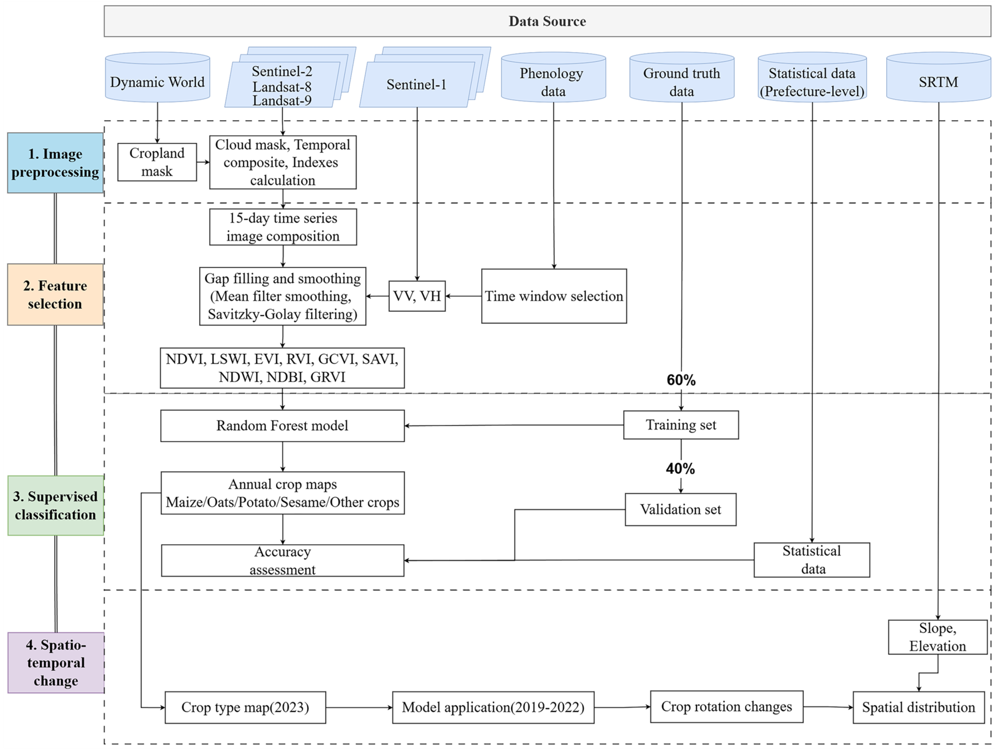
3.1. Construction of Vegetation Index Curves of Crops
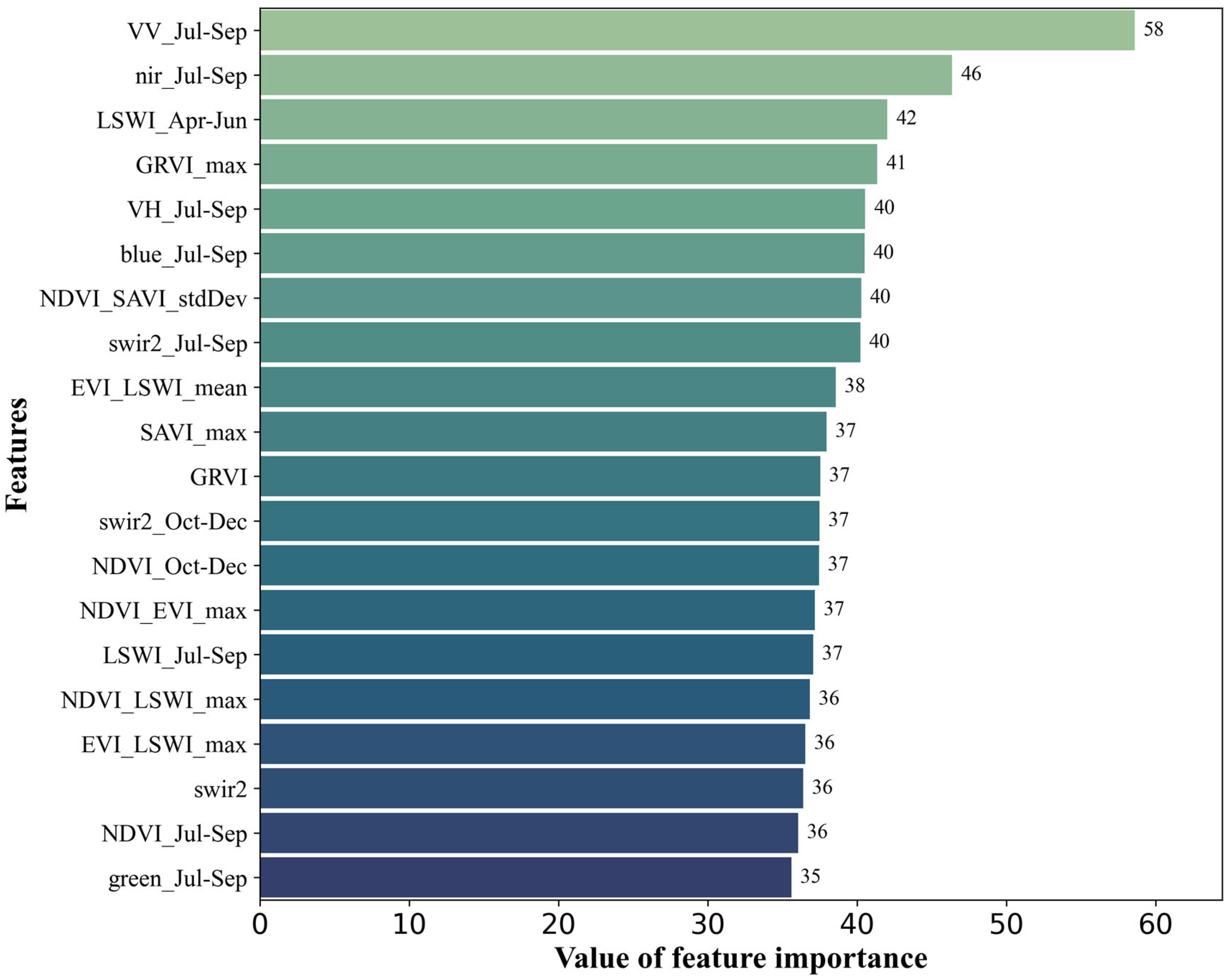
3.2. Crop-Type Mapping Algorithms and Parameter Setting
3.3. Accuracy Assessment
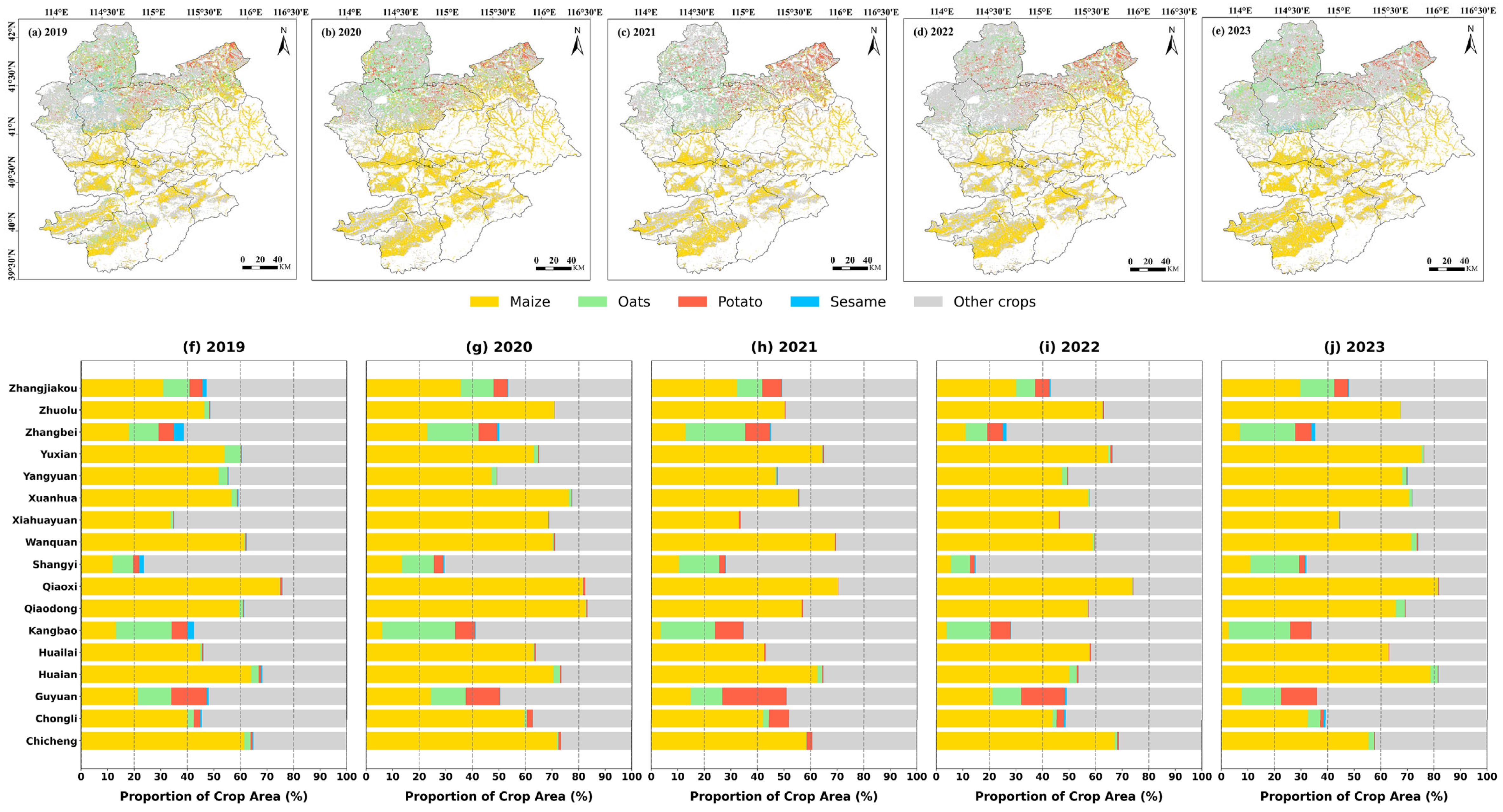
4. Results
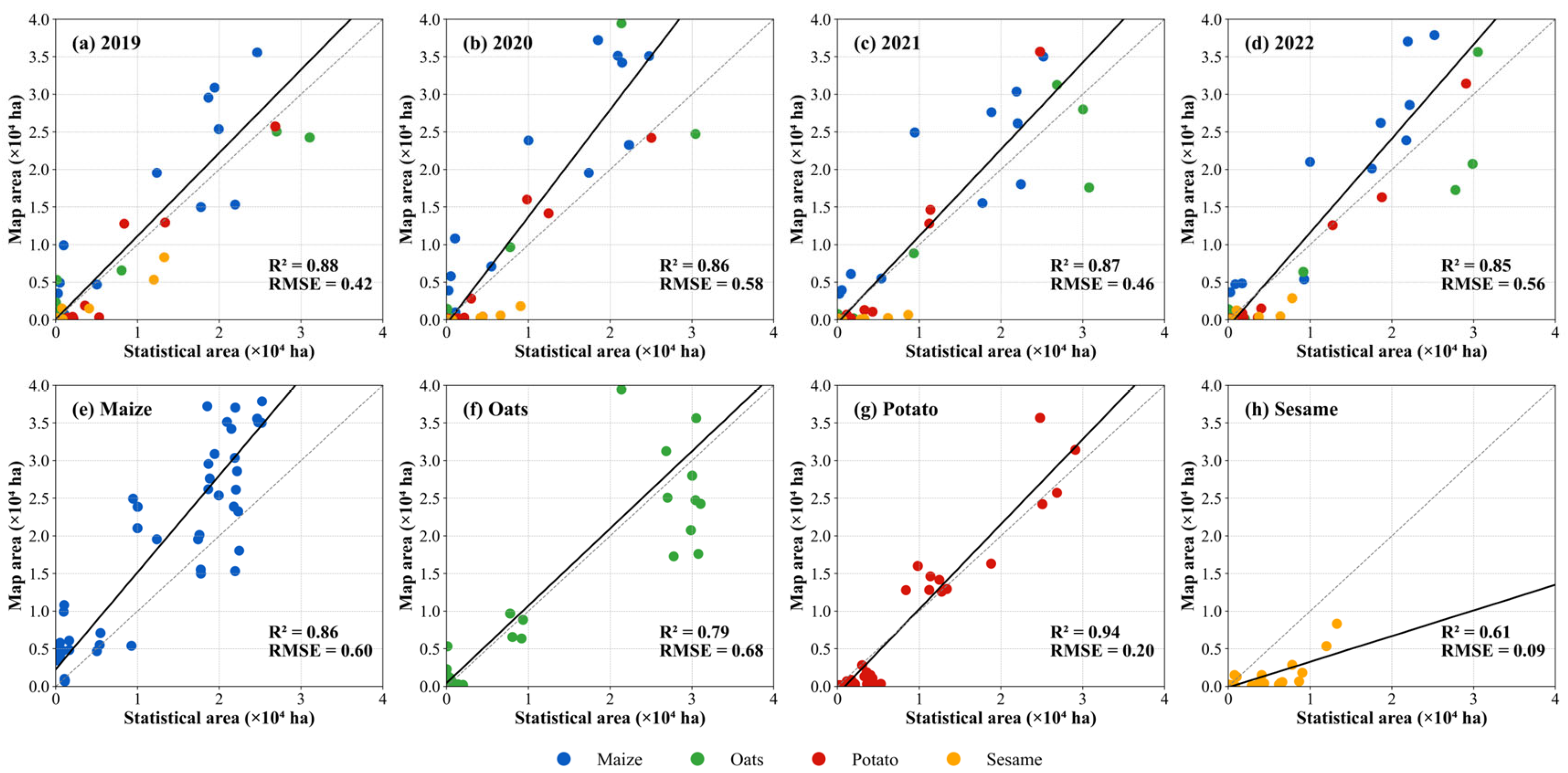
4.1. Classification Accuracy
4.2. Crop Distribution Patterns in Relation to Elevation and Slope
4.3. Analysis of Crop Rotation
5. Discussion
5.1. Factor Analysis of Changes in Crop Rotation Patterns
5.2. Innovations in Multi-Sensor Mapping of Crop Distribution in the FPEC
5.3. Limitations and Future Directions for Crop Classification and Rotation Analysis
6. Conclusions
Author Contributions
Funding
Data Availability Statement
Conflicts of Interest
Abbreviations
| FPEC | the farming–pastoral ecotone of China |
| SAR | Synthetic Aperture Radar |
| GEE | Google Earth Engine |
| RF | Random Forest |
References
- Shen, H.; He, Y.; Hu, W.; Geng, S.; Han, X.; Zhao, Z.; Li, H. The Temporal Evolution of Soil Erosion for Corn and Fallow Hillslopes in the Typical Mollisol Region of Northeast China. Soil Tillage Res. 2019, 186, 200–205. [Google Scholar] [CrossRef]
- Zhou, J.; Zhang, F.; Xu, Y.; Gao, Y.; Xie, Z. Evaluation of Land Reclamation and Implications of Ecological Restoration for Agro-Pastoral Ecotone: Case Study of Horqin Left Back Banner in China. Chin. Geogr. Sci. 2017, 27, 772–783. [Google Scholar] [CrossRef]
- Ali, A.; Hassan, M.U.; Kaul, H. Broad Scope of Site-Specific Crop Management and Specific Role of Remote Sensing Technologies Within It—A Review. J. Agron. Crop Sci. 2024, 210, e12732. [Google Scholar] [CrossRef]
- Li, S.; An, P.; Pan, Z.; Wang, F.; Li, X.; Liu, Y. Farmers’ Initiative on Adaptation to Climate Change in the Northern Agro-Pastoral Ecotone. Int. J. Disaster Risk Reduct. 2015, 12, 278–284. [Google Scholar] [CrossRef]
- Wuyun, D.; Sun, L.; Sun, Z.; Chen, Z.; Hou, A.; Teixeira Crusiol, L.G.; Reymondin, L.; Chen, R.; Zhao, H. Mapping Fallow Fields Using Sentinel-1 and Sentinel-2 Archives over Farming-Pastoral Ecotone of Northern China with Google Earth Engine. GISci. Remote Sens. 2022, 59, 333–353. [Google Scholar] [CrossRef]
- Chen, H.; Zhao, Y.; Fu, X.; Tang, M.; Guo, M.; Zhang, S.; Zhu, Y.; Qu, L.; Wu, G. Impacts of Regional Land-Use Patterns on Ecosystem Services in the Typical Agro-Pastoral Ecotone of Northern China. Ecosyst. Health Sustain. 2022, 8, 2110521. [Google Scholar] [CrossRef]
- Maestre, F.T.; Le Bagousse-Pinguet, Y.; Delgado-Baquerizo, M.; Eldridge, D.J.; Saiz, H.; Berdugo, M.; Gozalo, B.; Ochoa, V.; Guirado, E.; García-Gómez, M.; et al. Grazing and Ecosystem Service Delivery in Global Drylands. Science 2022, 378, 915–920. [Google Scholar] [CrossRef]
- Estel, S.; Kuemmerle, T.; Levers, C.; Baumann, M.; Hostert, P. Mapping Cropland-Use Intensity across Europe Using MODIS NDVI Time Series. Environ. Res. Lett. 2016, 11, 024015. [Google Scholar] [CrossRef]
- Zhou, Y.; Luo, J.; Feng, L.; Yang, Y.; Chen, Y.; Wu, W. Long-Short-Term-Memory-Based Crop Classification Using High-Resolution Optical Images and Multi-Temporal SAR Data. GISci. Remote Sens. 2019, 56, 1170–1191. [Google Scholar] [CrossRef]
- Pan, L.; Xia, H.; Zhao, X.; Guo, Y.; Qin, Y. Mapping Winter Crops Using a Phenology Algorithm, Time-Series Sentinel-2 and Landsat-7/8 Images, and Google Earth Engine. Remote Sens. 2021, 13, 2510. [Google Scholar] [CrossRef]
- Chen, Y.; Lu, D.; Moran, E.; Batistella, M.; Dutra, L.V.; Sanches, I.D.; da Silva, R.F.B.; Huang, J.; Luiz, A.J.B.; de Oliveira, M.A.F. Mapping Croplands, Cropping Patterns, and Crop Types Using MODIS Time-Series Data. Int. J. Appl. Earth Obs. Geoinf. 2018, 69, 133–147. [Google Scholar] [CrossRef]
- Wang, C.; Zhang, X.; Wang, W.; Wei, H.; Wang, J.; Li, Z.; Li, X.; Wu, H.; Hu, Q. Understanding the Potentials of Early-Season Crop Type Mapping by Using Landsat-8, Sentinel-1/2, and GF-1/6 Data. Comput. Electron. Agric. 2024, 224, 109239. [Google Scholar] [CrossRef]
- Wang, J.; Xiao, X.; Liu, L.; Wu, X.; Qin, Y.; Steiner, J.L.; Dong, J. Mapping Sugarcane Plantation Dynamics in Guangxi, China, by Time Series Sentinel-1, Sentinel-2 and Landsat Images. Remote Sens. Environ. 2020, 247, 111951. [Google Scholar] [CrossRef]
- Shen, Y.; Zhang, X.; Yang, Z. Mapping Corn and Soybean Phenometrics at Field Scales over the United States Corn Belt by Fusing Time Series of Landsat 8 and Sentinel-2 Data with VIIRS Data. ISPRS J. Photogramm. Remote Sens. 2022, 186, 55–69. [Google Scholar] [CrossRef]
- Ashourloo, D.; Shahrabi, H.S.; Azadbakht, M.; Rad, A.M.; Aghighi, H.; Radiom, S. A Novel Method for Automatic Potato Mapping Using Time Series of Sentinel-2 Images. Comput. Electron. Agric. 2020, 175, 105583. [Google Scholar] [CrossRef]
- Maponya, M.G.; van Niekerk, A.; Mashimbye, Z.E. Pre-Harvest Classification of Crop Types Using a Sentinel-2 Time-Series and Machine Learning. Comput. Electron. Agric. 2020, 169, 105164. [Google Scholar] [CrossRef]
- Blickensdörfer, L.; Schwieder, M.; Pflugmacher, D.; Nendel, C.; Erasmi, S.; Hostert, P. Mapping of Crop Types and Crop Sequences with Combined Time Series of Sentinel-1, Sentinel-2 and Landsat 8 Data for Germany. Remote Sens. Environ. 2022, 269, 112831. [Google Scholar] [CrossRef]
- Ibrahim, E.S.; Rufin, P.; Nill, L.; Kamali, B.; Nendel, C.; Hostert, P. Mapping Crop Types and Cropping Systems in Nigeria with Sentinel-2 Imagery. Remote Sens. 2021, 13, 3523. [Google Scholar] [CrossRef]
- Chen, S.; Useya, J.; Mugiyo, H. Decision-Level Fusion of Sentinel-1 SAR and Landsat 8 OLI Texture Features for Crop Discrimination and Classification: Case of Masvingo, Zimbabwe. Heliyon 2020, 6, e05358. [Google Scholar] [CrossRef]
- Fracastoro, G.; Magli, E.; Poggi, G.; Scarpa, G.; Valsesia, D.; Verdoliva, L. Deep Learning Methods For Synthetic Aperture Radar Image Despeckling: An Overview Of Trends And Perspectives. IEEE Geosci. Remote Sens. Mag. 2021, 9, 29–51. [Google Scholar] [CrossRef]
- Mercier, A.; Betbeder, J.; Baudry, J.; Le Roux, V.; Spicher, F.; Lacoux, J.; Roger, D.; Hubert-Moy, L. Evaluation of Sentinel-1 & 2 Time Series for Predicting Wheat and Rapeseed Phenological Stages. ISPRS J. Photogramm. Remote Sens. 2020, 163, 231–256. [Google Scholar] [CrossRef]
- Waldhoff, G.; Lussem, U.; Bareth, G. Multi-Data Approach for Remote Sensing-Based Regional Crop Rotation Mapping: A Case Study for the Rur Catchment, Germany. Int. J. Appl. Earth Obs. Geoinf. 2017, 61, 55–69. [Google Scholar] [CrossRef]
- Hufnagel, J.; Reckling, M.; Ewert, F. Diverse Approaches to Crop Diversification in Agricultural Research. A Review. Agron. Sustain. Dev. 2020, 40, 14. [Google Scholar] [CrossRef]
- Orynbaikyzy, A.; Gessner, U.; Conrad, C. Crop Type Classification Using a Combination of Optical and Radar Remote Sensing Data: A Review. Int. J. Remote Sens. 2019, 40, 6553–6595. [Google Scholar] [CrossRef]
- Luo, Y.; Zhang, Z.; Li, Z.; Chen, Y.; Zhang, L.; Cao, J.; Tao, F. Identifying the Spatiotemporal Changes of Annual Harvesting Areas for Three Staple Crops in China by Integrating Multi-Data Sources. Environ. Res. Lett. 2020, 15, 074003. [Google Scholar] [CrossRef]
- Qiu, B.; Hu, X.; Chen, C.; Tang, Z.; Yang, P.; Zhu, X.; Yan, C.; Jian, Z. Maps of Cropping Patterns in China during 2015–2021. Sci. Data 2022, 9, 479. [Google Scholar] [CrossRef]
- Du, G.; Yao, L.; Hou, D. The Spatio-Temporal Changes of Cropping Patterns in the Black Soil Area of China: Lessons from Wangkui County. Front. Environ. Sci. 2022, 10, 981721. [Google Scholar] [CrossRef]
- Yang, Z.; Chu, L.; Wang, C.; Pan, Y.; Su, W.; Qin, Y.; Cai, C. What Drives the Spatial Heterogeneity of Cropping Patterns in the Northeast China: The Natural Environment, the Agricultural Economy, or Policy? Sci. Total Environ. 2023, 905, 167810. [Google Scholar] [CrossRef]
- Liu, Z.; Liu, Y.; Dong, J.; Baig, M.H.A.; Chi, W.; Peng, L.; Wang, J. Patterns and Causes of Winter Wheat and Summer Maize Rotation Area Change over the North China Plain. Environ. Res. Lett. 2022, 17, 044056. [Google Scholar] [CrossRef]
- Li, J.; Lei, H. Tracking the Spatio-Temporal Change of Planting Area of Winter Wheat-Summer Maize Cropping System in the North China Plain during 2001–2018. Comput. Electron. Agric. 2021, 187, 106222. [Google Scholar] [CrossRef]
- He, Y.; Dong, J.; Liao, X.; Sun, L.; Wang, Z.; You, N.; Li, Z.; Fu, P. Examining Rice Distribution and Cropping Intensity in a Mixed Single- and Double-Cropping Region in South China Using All Available Sentinel 1/2 Images. Int. J. Appl. Earth Obs. Geoinf. 2021, 101, 102351. [Google Scholar] [CrossRef]
- Pan, L.; Xia, H.; Yang, J.; Niu, W.; Wang, R.; Song, H.; Guo, Y.; Qin, Y. Mapping Cropping Intensity in Huaihe Basin Using Phenology Algorithm, All Sentinel-2 and Landsat Images in Google Earth Engine. Int. J. Appl. Earth Obs. Geoinf. 2021, 102, 102376. [Google Scholar] [CrossRef]
- Chen, X.; Zhang, G.; Jin, Y.; Mao, S.; Laakso, K.; Sanchez-Azofeifa, A.; Jiang, L.; Zhou, Y.; Zhao, H.; Yu, L.; et al. Evaluating the Farmland Use Intensity and Its Patterns in a Farming—Pastoral Ecotone of Northern China. Remote Sens. 2021, 13, 4304. [Google Scholar] [CrossRef]
- Hu, Y.; Zeng, H.; Tian, F.; Zhang, M.; Wu, B.; Gilliams, S.; Li, S.; Li, Y.; Lu, Y.; Yang, H. An Interannual Transfer Learning Approach for Crop Classification in the Hetao Irrigation District, China. Remote Sens. 2022, 14, 1208. [Google Scholar] [CrossRef]
- Qi, H.; Qian, X.; Shang, S.; Wan, H. Multi-Year Mapping of Cropping Systems in Regions with Smallholder Farms from Sentinel-2 Images in Google Earth Engine. GISci. Remote Sens. 2024, 61, 2309843. [Google Scholar] [CrossRef]
- Li, G.; Cui, J.; Han, W.; Zhang, H.; Huang, S.; Chen, H.; Ao, J. Crop Type Mapping Using Time-Series Sentinel-2 Imagery and U-Net in Early Growth Periods in the Hetao Irrigation District in China. Comput. Electron. Agric. 2022, 203, 107478. [Google Scholar] [CrossRef]
- Chen, X.; An, P.; Laakso, K.; Arturo Sanchez-Azofeifa, G.; Wang, F.; Zhang, G.; Jiang, L.; Zhou, Y.; Lun, F.; Zou, L.; et al. Satellite-Based Observations of the Green Depressing Cropping System in a Farming-Pastoral Ecotone of Northern China. Int. J. Appl. Earth Obs. Geoinf. 2021, 98, 102312. [Google Scholar] [CrossRef]
- Yu, Q.; Hu, Q.; van Vliet, J.; Verburg, P.H.; Wu, W. GlobeLand30 Shows Little Cropland Area Loss but Greater Fragmentation in China. Int. J. Appl. Earth Obs. Geoinf. 2018, 66, 37–45. [Google Scholar] [CrossRef]
- Dong, Q.; Chen, X.; Chen, J.; Zhang, C.; Liu, L.; Cao, X.; Zang, Y.; Zhu, X.; Cui, X. Mapping Winter Wheat in North China Using Sentinel 2A/B Data: A Method Based on Phenology-Time Weighted Dynamic Time Warping. Remote Sens. 2020, 12, 1274. [Google Scholar] [CrossRef]
- Li, X.; Sun, C.; Meng, H.; Ma, X.; Huang, G.; Xu, X. A Novel Efficient Method for Land Cover Classification in Fragmented Agricultural Landscapes Using Sentinel Satellite Imagery. Remote Sens. 2020, 14, 2045. [Google Scholar] [CrossRef]
- Zurqani, H.A.; Post, C.J.; Mikhailova, E.A.; Schlautman, M.A.; Sharp, J.L. Geospatial Analysis of Land Use Change in the Savannah River Basin Using Google Earth Engine. Int. J. Appl. Earth Obs. Geoinf. 2018, 69, 175–185. [Google Scholar] [CrossRef]
- Mohammed, I.; Marshall, M.; de Bie, K.; Estes, L.; Nelson, A. A Blended Census and Multiscale Remote Sensing Approach to Probabilistic Cropland Mapping in Complex Landscapes. ISPRS J. Photogramm. Remote Sens. 2020, 161, 233–245. [Google Scholar] [CrossRef]
- Foerster, S.; Kaden, K.; Foerster, M.; Itzerott, S. Crop Type Mapping Using Spectral–Temporal Profiles and Phenological Information. Comput. Electron. Agric. 2012, 89, 30–40. [Google Scholar] [CrossRef]
- Brown, C.F.; Brumby, S.P.; Guzder-Williams, B.; Birch, T.; Hyde, S.B.; Mazzariello, J.; Czerwinski, W.; Pasquarella, V.J.; Haertel, R.; Ilyushchenko, S.; et al. Dynamic World, Near Real-Time Global 10 m Land Use Land Cover Mapping. Sci. Data 2022, 9, 251. [Google Scholar] [CrossRef]
- Phalke, A.R.; Özdoğan, M.; Thenkabail, P.S.; Erickson, T.; Gorelick, N.; Yadav, K.; Congalton, R.G. Mapping Croplands of Europe, Middle East, Russia, and Central Asia Using Landsat, Random Forest, and Google Earth Engine. ISPRS J. Photogramm. Remote Sens. 2020, 167, 104–122. [Google Scholar] [CrossRef]
- Zhang, H.; Du, H.; Zhang, C.; Zhang, L. An Automated Early-Season Method to Map Winter Wheat Using Time-Series Sentinel-2 Data: A Case Study of Shandong, China. Comput. Electron. Agric. 2021, 182, 105962. [Google Scholar] [CrossRef]
- Wei, P.; Ye, H.; Qiao, S.; Liu, R.; Nie, C.; Zhang, B.; Song, L.; Huang, S. Early Crop Mapping Based on Sentinel-2 Time-Series Data and the Random Forest Algorithm. Remote Sens. 2023, 15, 3212. [Google Scholar] [CrossRef]
- Obour, A.K.; Silveira, M.L.; Vendramini, J.M.B.; Jawitz, J.; O’Connor, G.A.; Sollenberger, L.E. A Phosphorus Budget for Bahiagrass Pastures Growing on a Typical Florida Spodosol. Agron. J. 2011, 103, 611–616. [Google Scholar] [CrossRef]
- Zhang, H.; Xiao, F.; He, W.; Chai, Z.; Ewe, H.-T. Multiyear Automated Mapping and Price Analysis of Garlic in Main Planting Areas of China Using Time-Series Remote Sensing Images. IEEE J. Sel. Top. Appl. Earth Obs. Remote Sens. 2022, 15, 5222–5233. [Google Scholar] [CrossRef]
- Zha, Y.; Gao, J.; Ni, S. Use of Normalized Difference Built-up Index in Automatically Mapping Urban Areas from TM Imagery. Int. J. Remote Sens. 2003, 24, 583–594. [Google Scholar] [CrossRef]
- Motohka, T.; Nasahara, K.N.; Oguma, H.; Tsuchida, S. Applicability of Green-Red Vegetation Index for Remote Sensing of Vegetation Phenology. Remote Sens. 2010, 2, 2369–2387. [Google Scholar] [CrossRef]
- Gumma, M.K.; Thenkabail, P.S.; Panjala, P.; Teluguntla, P.; Yamano, T.; Mohammed, I. Multiple Agricultural Cropland Products of South Asia Developed Using Landsat-8 30 m and MODIS 250 m Data Using Machine Learning on the Google Earth Engine (GEE) Cloud and Spectral Matching Techniques (SMTs) in Support of Food and Water Security. GISci. Remote Sens. 2022, 59, 1048–1077. [Google Scholar] [CrossRef]
- Griffiths, P.; Nendel, C.; Hostert, P. Intra-Annual Reflectance Composites from Sentinel-2 and Landsat for National-Scale Crop and Land Cover Mapping. Remote Sens. Environ. 2019, 220, 135–151. [Google Scholar] [CrossRef]
- Savitzky, A.; Golay, M.J.E. Smoothing and Differentiation of Data by Simplified Least Squares Procedures. Anal. Chem. 1964, 36, 1627–1639. [Google Scholar] [CrossRef]
- Hudait, M.; Patel, P.P. Crop-Type Mapping and Acreage Estimation in Smallholding Plots Using Sentinel-2 Images and Machine Learning Algorithms: Some Comparisons. Egypt. J. Remote Sens. Space Sci. 2022, 25, 147–156. [Google Scholar] [CrossRef]
- Wang, H.; Magagi, R.; Goïta, K.; Trudel, M.; McNairn, H.; Powers, J. Crop Phenology Retrieval via Polarimetric SAR Decomposition and Random Forest Algorithm. Remote Sens. Environ. 2019, 231, 111234. [Google Scholar] [CrossRef]
- You, N.; Dong, J.; Huang, J.; Du, G.; Zhang, G.; He, Y.; Yang, T.; Di, Y.; Xiao, X. The 10-m Crop Type Maps in Northeast China during 2017–2019. Sci. Data 2021, 8, 41. [Google Scholar] [CrossRef]
- Zhang, J.; Feng, L.; Yao, F. Improved Maize Cultivated Area Estimation over a Large Scale Combining MODIS–EVI Time Series Data and Crop Phenological Information. ISPRS J. Photogramm. Remote Sens. 2014, 94, 102–113. [Google Scholar] [CrossRef]
- Pelletier, C.; Valero, S.; Inglada, J.; Champion, N.; Dedieu, G. Assessing the Robustness of Random Forests to Map Land Cover with High Resolution Satellite Image Time Series over Large Areas. Remote Sens. Environ. 2016, 187, 156–168. [Google Scholar] [CrossRef]
- Foody, G.M. Status of Land Cover Classification Accuracy Assessment. Remote Sens. Environ. 2002, 80, 185–201. [Google Scholar] [CrossRef]
- Huang, X.; Huang, J.; Li, X.; Shen, Q.; Chen, Z. Early Mapping of Winter Wheat in Henan Province of China Using Time Series of Sentinel-2 Data. GISci. Remote Sens. 2022, 59, 1534–1549. [Google Scholar] [CrossRef]
- Zhang, G.; Chen, X.; Zhou, Y.; Zhao, H.; Jin, Y.; Luo, Y.; Chen, S.; Wu, X.; Pan, Z.; An, P. Land Use/Cover Changes and Subsequent Water Budget Imbalance Exacerbate Soil Aridification in the Farming-Pastoral Ecotone of Northern China. J. Hydrol. 2023, 624, 129939. [Google Scholar] [CrossRef]
- Yang, Y.; Wang, K.; Liu, D.; Zhao, X.; Fan, J. Effects of Land-Use Conversions on the Ecosystem Services in the Agro-Pastoral Ecotone of Northern China. J. Clean. Prod. 2020, 249, 119360. [Google Scholar] [CrossRef]
- Chen, X.; Jiang, L.; Zhang, G.; Meng, L.; Pan, Z.; Lun, F.; An, P. Green-Depressing Cropping System: A Referential Land Use Practice for Fallow to Ensure a Harmonious Human-Land Relationship in the Farming-Pastoral Ecotone of Northern China. Land Use Policy 2021, 100, 104917. [Google Scholar] [CrossRef]
- Liu, Y.; Xiao, X.; Li, J.; Wang, X.; Chen, B.; Sun, C.; Wang, J.; Tian, P.; Zhang, H. Tracking Changes in Coastal Land Cover in the Yellow Sea, East Asia, Using Sentinel-1 and Sentinel-2 Time-Series Images and Google Earth Engine. ISPRS J. Photogramm. Remote Sens. 2023, 196, 429–444. [Google Scholar] [CrossRef]
- Peng, Q.; Shen, R.; Li, X.; Ye, T.; Dong, J.; Fu, Y.; Yuan, W. A Twenty-Year Dataset of High-Resolution Maize Distribution in China. Sci. Data 2023, 10, 658. [Google Scholar] [CrossRef]

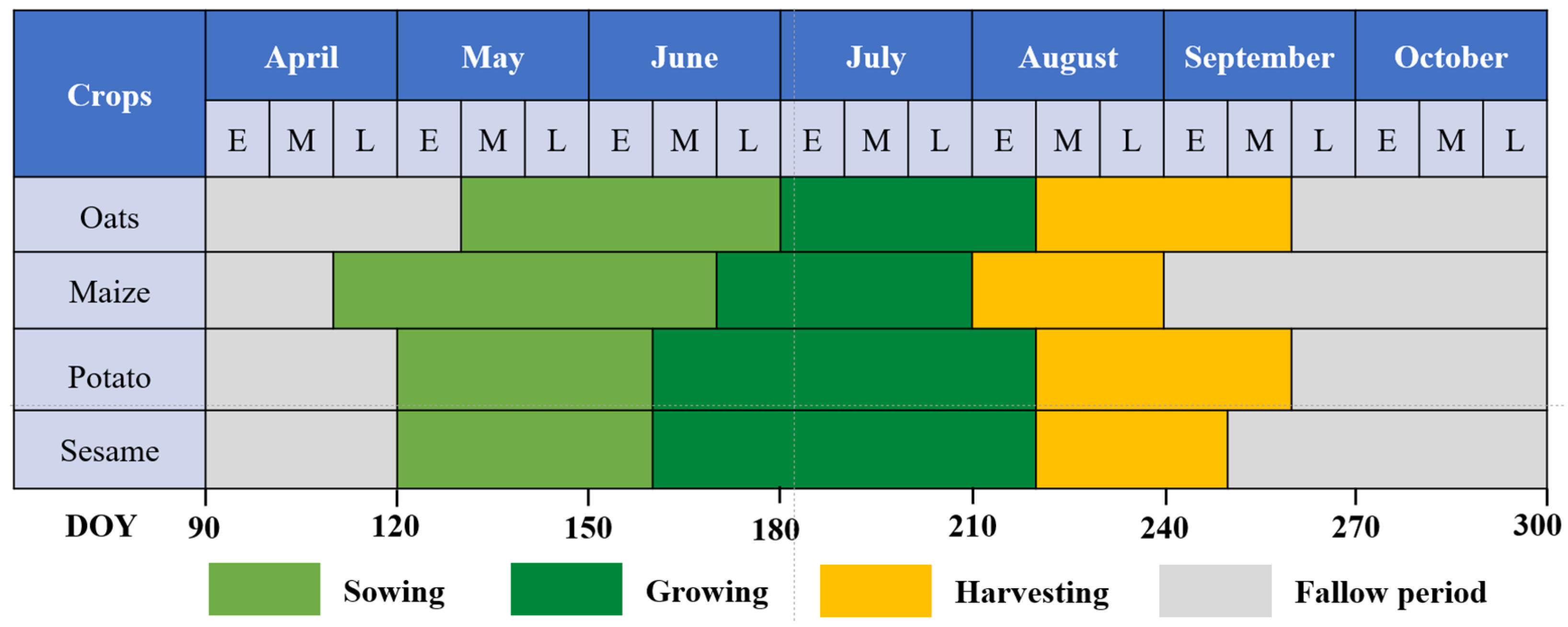
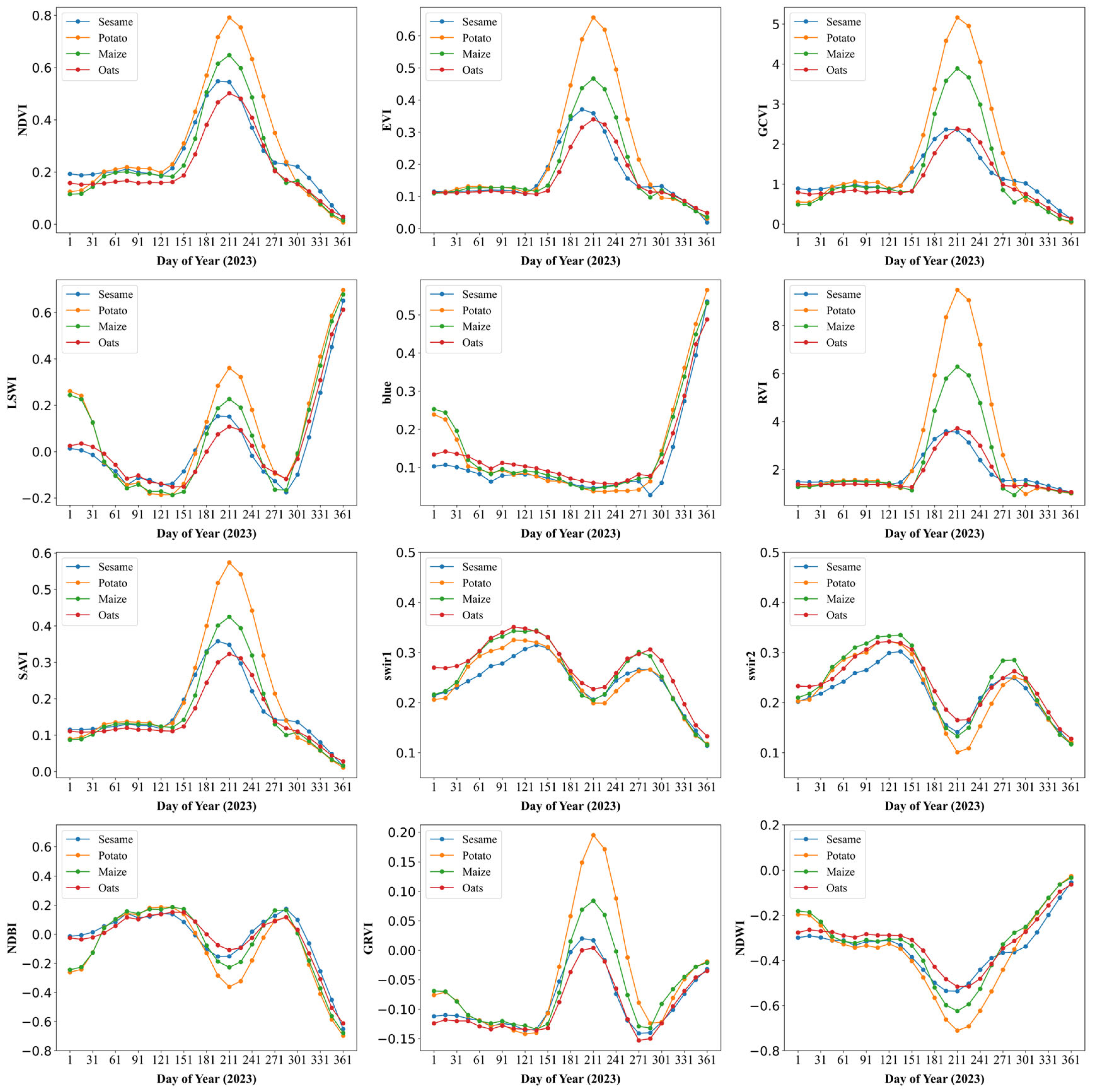
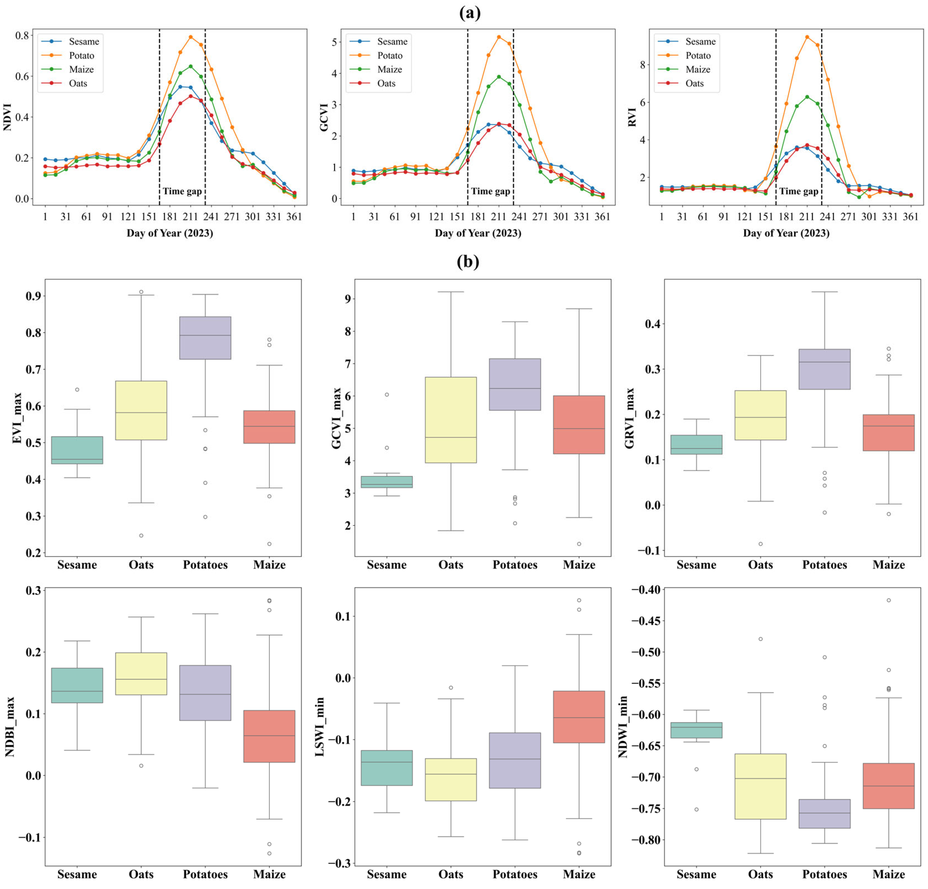


| Data | Time | Resolution | Data Access | Last Access (dd/mm/yyyy) |
|---|---|---|---|---|
| Sentinel-2 MSI | 2019, 2020, 2021, 2022, 2023 | 10 m | https://developers.google.com/earth-engine/datasets/catalog/COPERNICUS_S2 | 08 January 2025 |
| Landsat8/9 | 2019, 2020, 2021, 2022, 2023 | 30 m | https://developers.google.com/earth-engine/datasets/catalog/LANDSAT_LC08_C02_T1_L2; https://developers.google.com/earth-engine/datasets/catalog/LANDSAT_LC09_C02_T1_L2 | 08 January 2025 |
| Sentinel-1 SAR | 2019, 2020, 2021, 2022, 2023 | 10 m | https://developers.google.com/earth-engine/datasets/catalog/COPERNICUS_S1_GRD | 08 January 2025 |
| The Shuttle Radar Topography Mission (SRTM) | 2023 | 30 m | https://developers.google.com/earth-engine/datasets/catalog/USGS_SRTMGL1_003 | 08 January 2025 |
| Dynamic World | 2019, 2020, 2021, 2022, 2023 | 10 m | https://developers.google.com/earth-engine/datasets/catalog/GOOGLE_DYNAMICWORLD_V1 | 16 October 2024 |
| Agricultural statistics data | 2019–2022 | County | https://www.zjk.gov.cn | 05 December 2024 |
| Field survey sites | July 2023–August 2023 | In-situ | Field survey | July–August 2023 |
| Year | Crops | Maize | Oats | Potato | Sesame | Other Crops | Producer’s Acc. | F1 Score | Overall Acc. | Kappa |
|---|---|---|---|---|---|---|---|---|---|---|
| 2023 | Maize | 218 | 1 | 0 | 0 | 3 | 98.19 | 99.09 | 97.35 | 0.95 |
| Oats | 0 | 164 | 2 | 0 | 8 | 94.25 | 94.25 | |||
| Potato | 0 | 3 | 131 | 0 | 6 | 93.57 | 95.97 | |||
| Sesame | 0 | 6 | 0 | 19 | 2 | 70.37 | 82.60 | |||
| Other crops | 0 | 0 | 0 | 0 | 611 | 1 | 98.46 | |||
| User’s Acc. | 1 | 94.25 | 98.49 | 1 | 96.98 | |||||
| 2022 | Maize | 222 | 2 | 0 | 0 | 0 | 99.11 | 99.11 | 96.44 | 94.51 |
| Oats | 0 | 230 | 0 | 1 | 15 | 93.49 | 94.26 | |||
| Potato | 0 | 0 | 6 | 0 | 2 | 75 | 85.71 | |||
| Sesame | 0 | 1 | 0 | 5 | 0 | 83.33 | 83.33 | |||
| Other crops | 2 | 9 | 0 | 0 | 404 | 97.35 | 96.65 | |||
| User’s Acc. | 99.11 | 95.04 | 100 | 83.33 | 95.96 | |||||
| 2021 | Maize | 213 | 6 | 0 | 0 | 0 | 97.26 | 97.04 | 95.75 | 93.18 |
| Oats | 4 | 72 | 0 | 0 | 10 | 83.72 | 87.80 | |||
| Potato | 1 | 0 | 3 | 0 | 0 | 75 | 85.71 | |||
| Sesame | 0 | 0 | 0 | 1 | 0 | 100 | 100 | |||
| Other crops | 2 | 0 | 0 | 0 | 229 | 99.13 | 97.45 | |||
| User’s Acc. | 96.82 | 92.31 | 100 | 100 | 95.81 |
| Pattern in Cropping System | Crop Rotation | 2019–2020 | 2020–2021 | 2021–2022 | 2022–2023 | Average |
|---|---|---|---|---|---|---|
| Potato-dominated | P-P | 31.86 | 33.40 | 27.97 | 32.54 | 31.44 |
| P-O | 12.23 | 8.64 | 11.22 | 10.43 | 10.63 | |
| P-M | 20.56 | 9.18 | 17.53 | 12.30 | 14.89 | |
| P-S | 1.38 | 2.45 | 1.32 | 1.30 | 1.61 | |
| P-OC | 33.96 | 46.33 | 41.95 | 43.43 | 41.42 | |
| Oats-dominated | O-P | 7.12 | 10.58 | 6.83 | 10.75 | 8.82 |
| O-O | 40.63 | 30.59 | 21.79 | 40.78 | 33.45 | |
| O-M | 25.66 | 6.26 | 12.21 | 12.64 | 14.19 | |
| O-S | 1.10 | 3.11 | 1.80 | 1.52 | 1.88 | |
| O-OC | 25.49 | 49.45 | 57.37 | 34.3 | 41.65 | |
| Maize-dominated | M-P | 3.11 | 4.91 | 2.44 | 2.57 | 3.26 |
| M-O | 5.48 | 5.61 | 3.10 | 5.43 | 4.91 | |
| M-M | 77.4 | 60.20 | 78.11 | 75.56 | 72.82 | |
| M-S | 0.86 | 1.45 | 1.03 | 1.15 | 1.12 | |
| M-OC | 13.15 | 27.82 | 15.32 | 15.3 | 17.90 | |
| Sesame-dominated | S-P | 5.19 | 7.67 | 6.36 | 5.07 | 6.07 |
| S-O | 20.67 | 9.72 | 7.30 | 12.92 | 12.65 | |
| S-M | 27.31 | 11.1 | 14.36 | 16.95 | 17.43 | |
| S-S | 4.79 | 5.60 | 3.50 | 9.39 | 5.82 | |
| S-OC | 42.03 | 65.91 | 68.47 | 55.67 | 58.02 | |
| Other crops-dominated | OC-P | 4.73 | 6.25 | 4.29 | 3.93 | 4.80 |
| OC-O | 7.95 | 5.20 | 4.53 | 9.43 | 6.78 | |
| OC-M | 14.42 | 5.69 | 9.08 | 10.64 | 9.96 | |
| OC-S | 1.87 | 2.11 | 1.16 | 1.48 | 1.66 | |
| OC-OC | 71.03 | 80.74 | 80.95 | 74.53 | 76.81 |
Disclaimer/Publisher’s Note: The statements, opinions and data contained in all publications are solely those of the individual author(s) and contributor(s) and not of MDPI and/or the editor(s). MDPI and/or the editor(s) disclaim responsibility for any injury to people or property resulting from any ideas, methods, instructions or products referred to in the content. |
© 2025 by the authors. Licensee MDPI, Basel, Switzerland. This article is an open access article distributed under the terms and conditions of the Creative Commons Attribution (CC BY) license (https://creativecommons.org/licenses/by/4.0/).
Share and Cite
Hou, Z.; Chen, B.; Liu, Y.; Zang, H.; Manevski, K.; Chen, F.; Yang, Y.; Ge, J.; Zeng, Z. High Resolution Crop Type and Rotation Mapping in Farming–Pastoral Ecotone in China Using Multi-Satellite Imagery and Google Earth Engine. Remote Sens. 2025, 17, 1707. https://doi.org/10.3390/rs17101707
Hou Z, Chen B, Liu Y, Zang H, Manevski K, Chen F, Yang Y, Ge J, Zeng Z. High Resolution Crop Type and Rotation Mapping in Farming–Pastoral Ecotone in China Using Multi-Satellite Imagery and Google Earth Engine. Remote Sensing. 2025; 17(10):1707. https://doi.org/10.3390/rs17101707
Chicago/Turabian StyleHou, Zhenwei, Bangqian Chen, Yaqun Liu, Huadong Zang, Kiril Manevski, Fangmiao Chen, Yadong Yang, Junyong Ge, and Zhaohai Zeng. 2025. "High Resolution Crop Type and Rotation Mapping in Farming–Pastoral Ecotone in China Using Multi-Satellite Imagery and Google Earth Engine" Remote Sensing 17, no. 10: 1707. https://doi.org/10.3390/rs17101707
APA StyleHou, Z., Chen, B., Liu, Y., Zang, H., Manevski, K., Chen, F., Yang, Y., Ge, J., & Zeng, Z. (2025). High Resolution Crop Type and Rotation Mapping in Farming–Pastoral Ecotone in China Using Multi-Satellite Imagery and Google Earth Engine. Remote Sensing, 17(10), 1707. https://doi.org/10.3390/rs17101707


