Article

Performance Analysis of Multi-GNSS Real-Time PPP-AR Positioning Considering SSR Delay

College of Geological Engineering and Geomatics, Chang’an University, Xi’an 710054, China
*
Author to whom correspondence should be addressed.
Remote Sens. 2024, 16(7), 1213; https://doi.org/10.3390/rs16071213
Submission received: 16 January 2024 / Revised: 27 March 2024 / Accepted: 28 March 2024 / Published: 29 March 2024

Abstract

:
For real-time (RT) precise point positioning (PPP), the state space representation (SSR) information is often delayed due to possible communication delays and specific broadcast intervals. In this case, the positioning results will diverge and re-converge due to the increase of SSR products extrapolation errors. In addition, RT orbit and clock offset accuracy, as well as their extrapolation errors, will vary in different systems and satellites. We propose a PPP with ambiguity resolution (PPP-AR) method that combines a time-differenced carrier phase (TDCP) model, in which the characteristics of the orbit and clock are considered. Under normal communication, the PPP-AR solution is obtained by fixing satellites with small SSR product errors. When the communication is abnormal, the TDCP model is utilized to extrapolate user coordinates by considering different extrapolation error characteristics of satellites. The experimental results show that GPS and Galileo SSR products have better accuracy than BDS, with signal-in-space user ranger errors (SISREs) of 2.7, 2.2, and 8.6 cm, respectively. Optimizing the PPP stochastic model based on SISREs can effectively reduce the convergence time. Under 5 min SSR delay, SISREs caused by clock and orbit extrapolation for GPS/Galileo/BDS are 3.5, 1.4, and 2.6 cm, respectively. After optimizing the TDCP stochastic model based on extrapolation errors, the horizontal and vertical positioning accuracies can be maintained at 0.7 cm and 5.0 cm. For multi-GNSS, the combination of the TDCP and PPP-AR can overcome the influence of short delay. After optimizing the stochastic model, the GPS/Galileo/BDS positioning accuracy can be maintained at about 2.4 cm under 3 min delay, showing an accuracy improvement rate of 59.3% compared with the traditional method using only PPP. Additionally, the rapid PPP convergence results can be obtained by inheriting previous filter state information when the communication recovers normally.

1. Introduction

The global satellite navigation system (GNSS) can provide high-quality positioning, navigation, and timing services for users around the world, with unique advantages in many fields of geoscientific research and applications [1,2]. Precise point positioning (PPP) technology has gradually developed into a research front in the field of satellite navigation and positioning due to its own advantages and characteristics, demonstrating broad application prospects. In real-time (RT) positioning, PPP with ambiguity resolution (PPP-AR) highly relies on the support of external organizations, which provide precise products or broadcast correction information [3,4]. Regardless of the communication mode, RT-PPP generally requires the user to receive correction information from the server continuously in real time, imposing rigorous requirements on the accuracy and timeliness of provided products [5,6]. In order to address the high precision and real-time application needs of the global satellite navigation system, the international GNSS service (IGS) established the real-time working group in 2001. Subsequently, in 2007, the organization officially started the real-time service (RTS) to provide RT corrections based on state space representation (SSR). Indeed, corrections from the server are not broadcast all the times but are updated at a specific interval. SSR corrections are typically broadcast at intervals of 5 s or more. This implies that the correction information received by the client is not exactly “real-time” but rather possesses a certain data age. Moreover, there will be a certain delay in the corrections generated from the server sent to the user due to possible communication instability. The data age of SSR incorporates both the effects of delay and update frequency. In this case, the delay includes communication, computation, and broadcasting delay. The primary challenge in RT-PPP lies in maintaining the continuity and real-time performance of positioning, which is adversely affected by delays in receiving precise orbit and clock corrections. It is very common for synchronous precise orbit and clock offset corrections to be unattainable due to unstable communication links in practical applications [7,8].
The large SSR delay can directly lead to jumping and the re-convergence of PPP-AR results, failing to meet the demands of highly time-efficient and accurate applications. For this reason, in most studies, the effectiveness of RT-PPP results is preserved by forecasting predictions of precise orbit and clock offsets when communication delays occur. Yang et al. [9] proposed satellite clock prediction for different update intervals and applied it to RT-PPP. If a sudden communication break takes place, the interruption period for receiving orbit and clock corrections may extend from a few minutes to hours. El-Mowafy et al. [10,11] adopted prediction products with a specific method based on short- and long-term interruptions to address disruptions of precise orbit and clock corrections in RT-PPP applications. The three-dimensional (3D) accuracy of the method is maintained within a decimeter when such a break occurs. At the same time, positioning results in different scenarios also entirely proved the effectiveness of this method. Nie et al. [12] constructed a clock prediction model that eliminates the need to store received RTS clock offset corrections. This model facilitates clock offset prediction even with just one epoch of RTS data, addressing interruptions in the reception of RTS products. Different from the previous method of directly predicting orbits and clocks, Zhao et al. [13] proposed an alternative method that utilizes broadcast ephemeris to generate comprehensive corrections including orbit errors, satellite clock errors, and receiver correlation errors. Additionally, PPP-AR can also provide solutions by extrapolation using previous SSR information during communication interruptions. But, it is prone to the re-convergence phenomenon for data recovery, which affects the high precision and continuity of real-time positioning.
Therefore, it is important to overcome the problem of abnormal results caused by SSR delay in order to promote the application of RT-PPP. The time-differenced carrier phase (TDCP) method proposed by related scholars can overcome such problems to some extent. The TDCP is a method for accurate velocity estimation, while also obtaining accurate relative positional information during the calculation process [14,15,16]. Similar to PPP, the time-differenced carrier phase (TDCP) is a method for accurate position estimation using only one receiver and can theoretically be combined with PPP. It can be used directly to estimate precise velocity without fixing the ambiguity, demonstrating nice positioning performance. Some studies have applied it to high-precision real-time earthquake monitoring [17,18]. The PPP method, based on the mixed use of time-differenced and undifferenced carrier phase observations, can effectively improve positioning accuracy and computational efficiency, which has significant advantages in high-speed positioning [19]. Using the TDCP model to extrapolate the receiver’s position during SSR delay can protect the PPP filter from large orbit and clock errors. Consequently, PPP can converge rapidly by inheriting the previous state information when communication returns to normal.
Along with the development of a new generation of navigation satellite systems, such as BDS and Galileo, multi-GNSS has become the predominant trend in current high-precision positioning. Combined observations significantly increase the number of visible satellites, enhance space geometry configurations, and provide valuable advantages for high-precision positioning. Nonetheless, it is important to note that the accuracy of orbits and clocks for different satellites in multi-GNSS systems can vary significantly, which introduces complexities and challenges in error modeling and the reduction in positioning errors. For RT PPP-AR, the positioning performance highly relies on precise product quality as well as extrapolation errors under SSR delay [20].
As a result, this study proposes the PPP-AR method that takes into account differences in the performance of RT products to further enhance positioning reliability. In this study, the PPP-AR method considering the accuracy and extrapolation errors of precise products was introduced first. When SSR delay occurs, the method uses the TDCP model for positioning. Then, the quality of RT multi-GNSS precise products from the Centre National D’Etudes Spatiales (CNES) was evaluated, and the stochastic model was optimized based on signal-in-space user ranger errors (SISREs). Finally, by utilizing high-frequency observation data from the Multi-GNSS Experiment (MGEX), it has been verified that the proposed method is effective in avoiding abnormal positioning solutions and improving the positioning accuracy when the SSR delay occurs.

2. Methodology

In the data processing of real-time PPP-AR, orbit, and clock errors are important factors affecting positioning performance. Once the communication link is blocked, the accuracy of the calculated orbit and clock will degrade, and positioning results will diverge. In this study, we propose an RT multi-GNSS PPP-AR method that takes into account SSR delay, in which the characteristics of the orbit and clock themselves and their extrapolation errors are carefully considered.

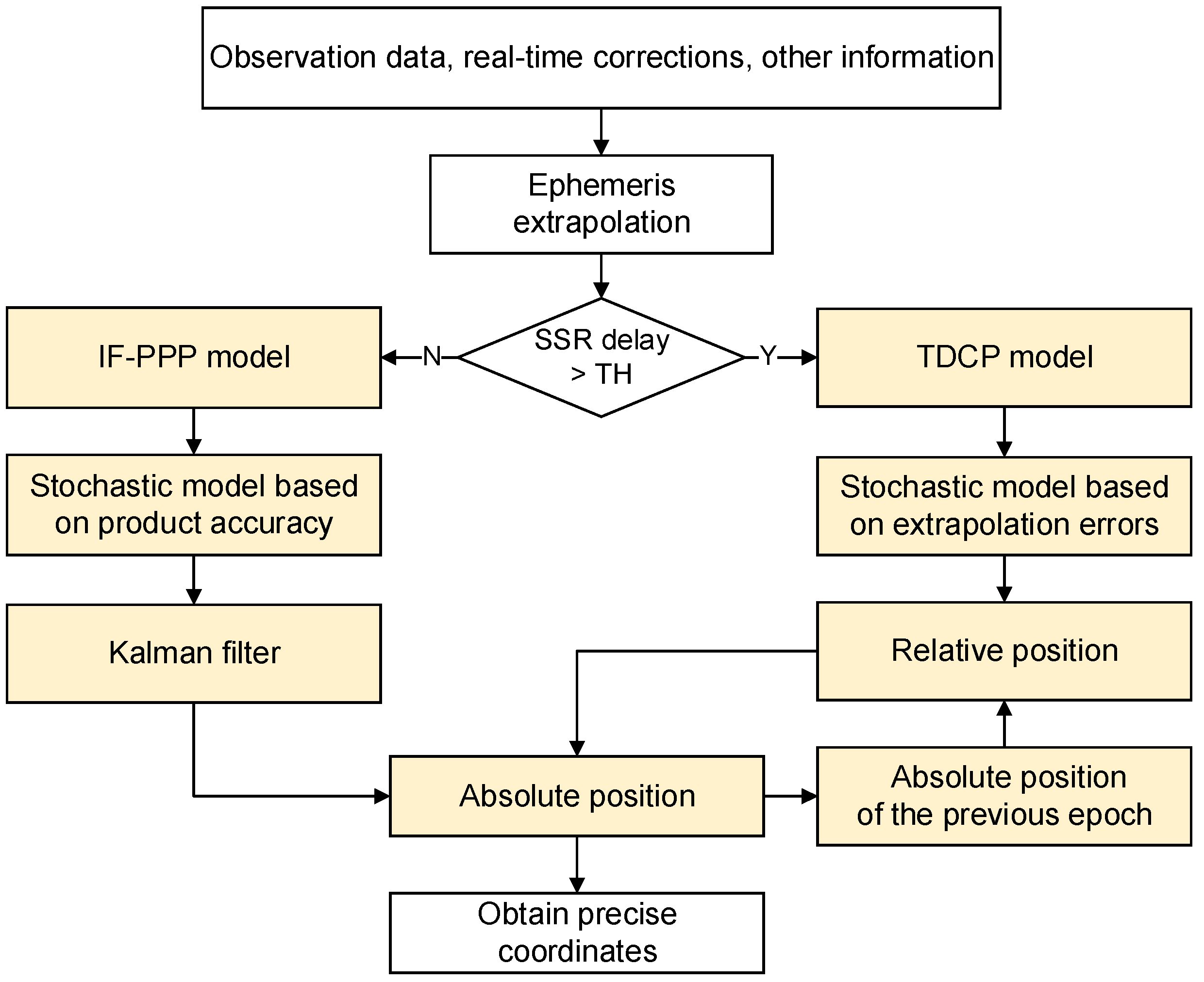
2.1. General Idea on PPP-AR Considering SSR Delay

The general thought of this method is shown in Figure 1. When the communication is normal, the receiver position is solved by the ionosphere-free (IF) PPP-AR model, and the stochastic model is optimized by considering the accuracy of multi-GNSS orbit and clock products. When the SSR delay occurs, the TDCP model is used to acquire relative coordinates, and the stochastic model is optimized based on extrapolation errors of multi-GNSS products. Note that the SSR corrections are updated within specific intervals. Even if there is no communication delay, the orbit and clock will be frequently extrapolated with the fresh SSR corrections. As a result, the TDCP model will be started only when the time delay exceeds a certain threshold value. Also, it should be noted that the accuracy of coordinates derived by both the TDCP and PPP models will decrease with an increase in communication latency. However, using the TDCP model can protect the PPP model from large orbit and clock errors. Inheriting the previous filter state information, such as troposphere and ambiguity parameters, enables the PPP filter to recover and converge rapidly when communication becomes normal.

2.2. Multi-GNSS PPP Aided with the TDCP Model

The dual-frequency IF combination is one of the commonly used PPP models [21]. This model combines dual-frequency pseudo-ranges and carrier phases, respectively, to eliminate the impact of the ionosphere. The IF pseudo-range and carrier phase measurements can be expressed as follows:
P I F , r s , n = ρ r s , n + c δ t r s + d I F , r s c δ t s , n + d I F s , n + d o r b s , n + T r s , n + ε P I F , r s , n L I F , r s , n = ρ r s , n + c δ t r s + d I F , r s c δ t s , n + d I F s , n + d o r b s , n + T r s , n + λ I F N I F , r s , n + b I F , r s b I F s , n c d I F , r s d I F s , n + ε L I F , r s , n
where P and L denote pseudo-range and carrier phase observations, respectively; superscripts s and n refer to the GNSS system and the satellite pseudo-random noise (PRN), respectively; subscript r refers to the receiver; f is the frequency, i and j are different frequency points; ρ r s , n denotes the geometric distance between the satellite and receiver; c is the speed of light; δ t r s and δ t s , n are the satellite and receiver clock offset; d o r b s , n is the orbit error; T r s , n is the tropospheric delay; d I F , r s ,   d I F s , n , b I F , r s , and b I F s , n are the uncalibrated pseudo-range and phase delays for the receiver and satellite, respectively; λ I F is the IF combination wavelength; N I F , r s , n is the integer phase ambiguity; ε L I F , r s , n and ε L I F , r s , n are the sum of other unmodeled errors and noise for pseudo-range and carrier phase measurements. This observation equation is also applicable to multi-GNSS PPP. At this point, the number of receiver clock offset parameters is the number of participating systems [22].
The satellite clock offset and pseudo-range hardware delays can be corrected with the IGS clock products. The receiver clock offset and ambiguity can be re-parameterized as follows:
δ t ^ r s = δ t r s + d I F , r s λ I F s B I F , r s , n = λ I F s b I F , r s c d I F , r s + c d I F , r s , n λ I F s b I F , r s , n + λ I F s N I F , r s , n
The slant troposphere wet delay for all satellites can be represented by one zenith troposphere parameter with mapping coefficients. The parameters to be estimated in the equation are as follows:
X = x , c δ t ^ r s , d t r o p , r , B I F , r s , 1 , , B I F , r s , m T
where x is the receiver coordinates; δ t ^ r s is the receiver clock offset; d t r o p , r is the zenith tropospheric wet delay; and B I F , r s , represents the ambiguity (assuming m satellites are observed). The IF ambiguity is commonly divided into wide-lane and narrow-lane ambiguities, each of which is individually fixed to restore the integer properties of the IF ambiguity.
When an SSR delay occurs, the receiver coordinates x t , y t , z t at the current epoch can be obtained by following equations:
x t = x t 0 + Δ r u x y t = y t 0 + Δ r u y z t = z t 0 + Δ r u z
where x t 0 , y t 0 , z t 0 denotes the last absolute coordinates obtained by PPP at the moment before the SSR delay occurs; the term Δ r u * represents the relative position derived from the TDCP model. In Equation (1), the carrier phase TDCP model between two epochs t 0 and t can be expressed as follows:
Δ L I F , r s , n = L I F , r s , n t L I F , r s , n t 0 = Δ ρ r s , n + c Δ δ t r s Δ δ t s , n + Δ T r s , n + λ I F Δ N I F , r s , n + Δ ε
where Δ represents the differencing operation. For example, Δ ρ r s , n = ρ r s , n t ρ r s , n t 0 represents the change in geometric distance between two epochs, and other terms in Equation (5) are defined accordingly. The ionospheric delay has been eliminated through the IF combination. In the absence of cycle jumps, ambiguities are also eliminated, along with the majority of common model errors that change gradually within a limited sampling rate [23]. The unified expression of this model is as follows:
Δ L I F , r s , n = Δ ρ r s , n + c Δ δ t r s + Δ ε
where Δ ε primarily represents receiver noise and minimal uncanceled errors. The linearization of the equation above can be written as follows:
Δ L I F , r s , n = e x   e y   e z   1 Δ x r Δ y r Δ z r c Δ δ t r s + Δ ε
where e x   e y   e z   1 is the matrix of coefficients. Δ x r , Δ y r , Δ z r , and Δ δ t r s represent the change components of the receiver position and clock between two epochs.

2.3. Methods for Evaluating Orbit and Clock Errors

Multi-GNSS positioning can further increase the number of visible satellites and optimize the geometric configuration of constellations [24,25]. In the conventional stochastic model of the multi-GNSS PPP and TDCP, satellite elevation angles are utilized to characterize the random properties of observations. The altitude angle stochastic model represents a functional model that defines the weight–ratio relationship among observations, considering the variations in observation quality with the satellite altitude. The typical expression for the stochastic model based on satellite elevation angles is as follows [26]:
σ u e e 2 = σ 0 2 sin 2 E l
where σ u e e 2 represents receiver-side observation noise; E l represents the satellite elevation angle; and σ 0 2 denotes the reference variance of observations.
The PPP performance of the terminal is closely associated with the accuracy of the clock and orbit products broadcasted by the server. Due to factors such as satellite constellation characteristics, solar elevation angles, and orbit types, there are differences in the clock and orbit products and their extrapolation errors among different systems [27,28]. By addressing errors in satellite clocks and orbits, optimizing the stochastic model can significantly reduce conventional errors and enhance convergence speed [29]. The SISRE is not only the primary parameter describing spatial signal accuracy but also a critical indicator that affects GNSS positioning services’ performance. This index reflects the combined impact of orbit and clock errors within the broadcast ephemeris on users ranging under specific data age conditions. It provides a more comprehensive assessment of system performance [30,31]. We can optimize the stochastic models of the PPP and TDCP based on the calculated SISRE, which can be expressed as follows:
σ 2 = σ u e e 2 + σ S I S R E s , n 2
where σ u e e 2 represents receiver-side observation noise; σ S I S R E s , n 2 signifies the SISRE; and superscripts s and n refer to the GNSS system and the satellite PRN, respectively. During normal communication, the PPP model is used, and the stochastic model can be optimized based on the SISRE value of precise products themselves. The term σ S I S R E s , n 2 specifically represents the SISRE derived from orbit and clock offset errors. The TDCP performance is primarily influenced by the geometric distribution of satellites and the accuracy in extrapolating real-time precise ephemeris data [32,33]. When SSR messages are delayed, the TDCP model is used, introducing additional extrapolation errors into the calculations of orbit and clock offset. The stochastic model can be optimized based on the SISRE value for extrapolation errors. The term σ S I S R E s , n 2 represents the SISRE derived from orbit and clock extrapolation during SSR delay.
The clock-only and orbit-only contributions to SISREs can be expressed as follows [34,35]:
S I S R E c l k = R M S c o c l k S I S R E o r b = α 2 R M S o R 2 + R M S o A 2 + R M S o C 2 / β
where o c l k denotes the clock offset error and o R , o A , o C represent orbit errors in the radial, along-track, and cross-track directions, respectively. The calculation coefficients α and β depend on the altitude of the satellite, with values for different systems provided in Table 1. Taking into account the influence of both clock offset and orbit errors, the SISRE can be expressed as follows:
S I S R E = α R M S o R R M S c o c l k 2 + R M S o A 2 + R M S o C 2 / β
The root-mean-square (RMS) errors in Equations (10) and (11) can be derived as follows:
R M S o P = i = 1 N o P t i 2 / N
where P = R , A , C , c l k ; o P t i denotes the clock offset or orbit error at time t i ; and N denotes the number of samples.
o P is calculated differently for the two cases of normal communication and the occurrence of SSR delay in Equations (10) and (11). Taking clock offset as an example, under normal communication, the clock error is calculated following the restoration of the real-time clock offset with SSR corrections as follows:
o c l k t = d t r t s t d t r t r e f t d t p o s t s t d t p o s t r e f t
where d t t denotes the satellite clock offset at time t ; superscripts s and r e f indicate a satellite and a reference satellite, respectively; and subscripts r t and p o s t are for real-time and post-precise products, respectively. When SSR messages are delayed, additional extrapolation errors are introduced into the clock offset calculation. The term o c l k can be determined by the following equation:
o c l k t t 0 = d t r t , t 0 s t d t r t , t 0 s t 0 d t p o s t s t d t p o s t s t 0
where t and t 0 denote the current time and the time stamp of the newest SSR messages, respectively; t t 0 means the time delay of SSR messages; d t r t , t 0 s t is the extrapolated clock offset at time t , which is calculated by the newest SSR messages; d t r t , t 0 s t 0 is the clock offset at time t 0 computed through the broadcast ephemeris and SSR corrections; and d t p o s t s t and d t p o s t s t 0 represent the clock offsets of post-precise product at times t and t 0 , respectively.

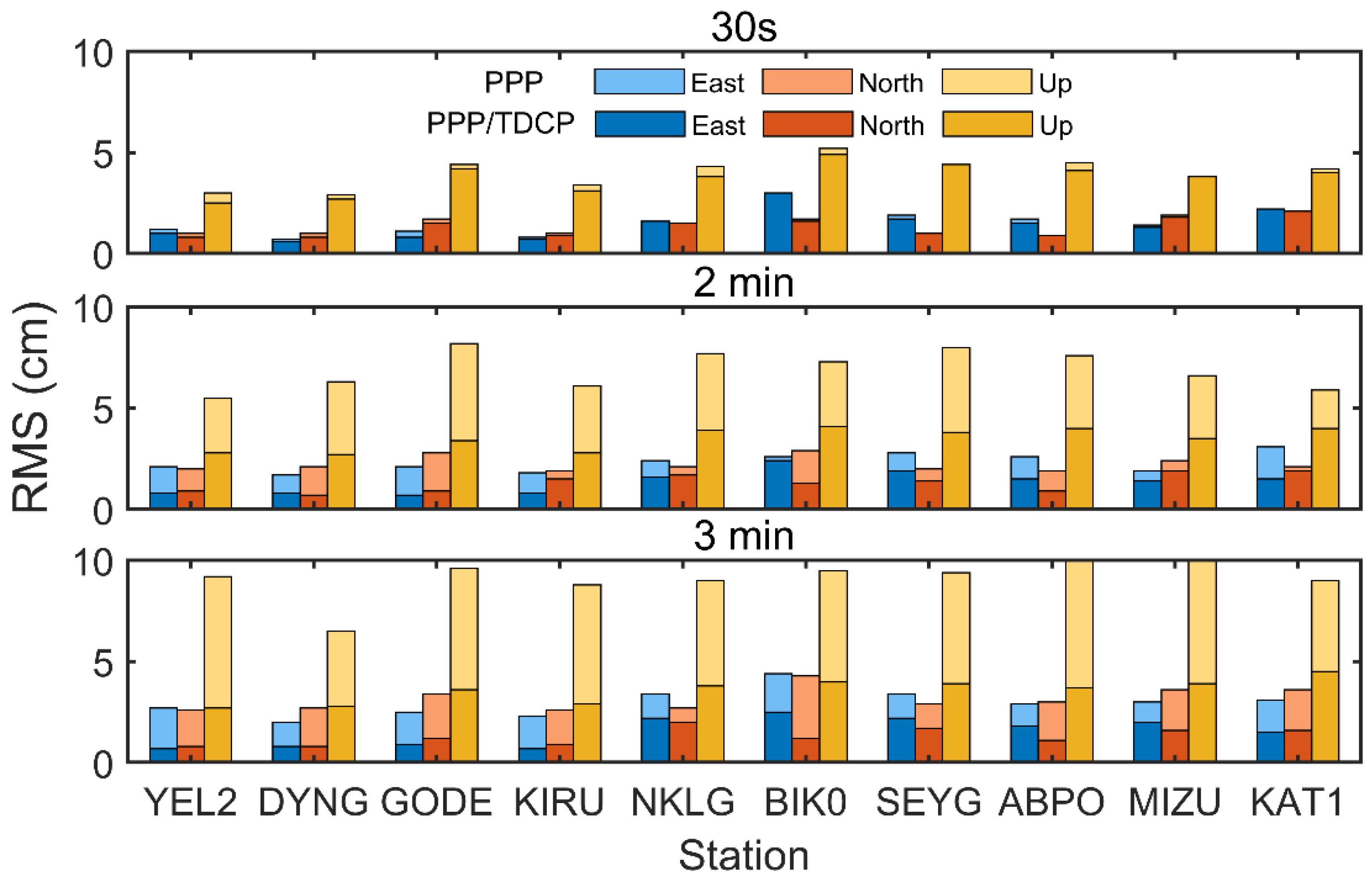
3. Experiment and Analysis

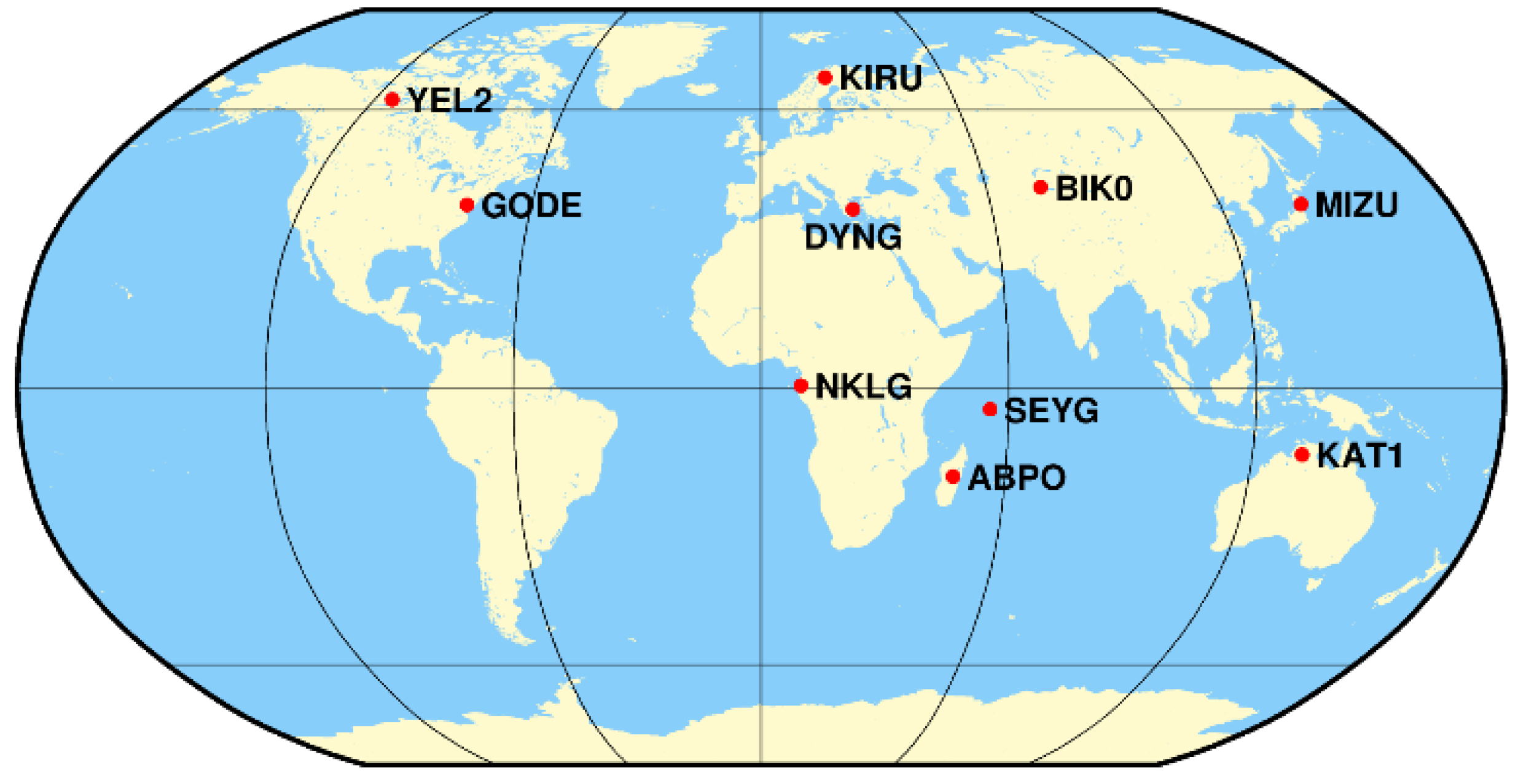
3.1. Data Collection and Processing Strategies

As depicted in Figure 2, observation data from 10 MGEX stations during DOY 121-127, 2022, were utilized to assess the positioning performance under SSR delay. All the receivers were equipped to receive dual-frequency signals from GPS, Galileo, and BDS, with a data sample interval of 1 s. RT precise orbit, clock, and observable-specific signal bias (OSB) products for the same period were also acquired from the CNES. The sample intervals for orbit, clock, and OSB data were 5 min, 5 s, and 30 s, respectively. To evaluate the SISRE of precise products, post-precise products from Wuhan University were used as the reference. In order to assess the effectiveness of the proposed model under varying delays, SSR delay was simulated from 1 s to 300 s in this study. For the PPP-AR model, the processing strategies and data settings are outlined in Table 2. The TDCP also uses the IF combination to eliminate the impact of ionospheric delay during the positioning process.

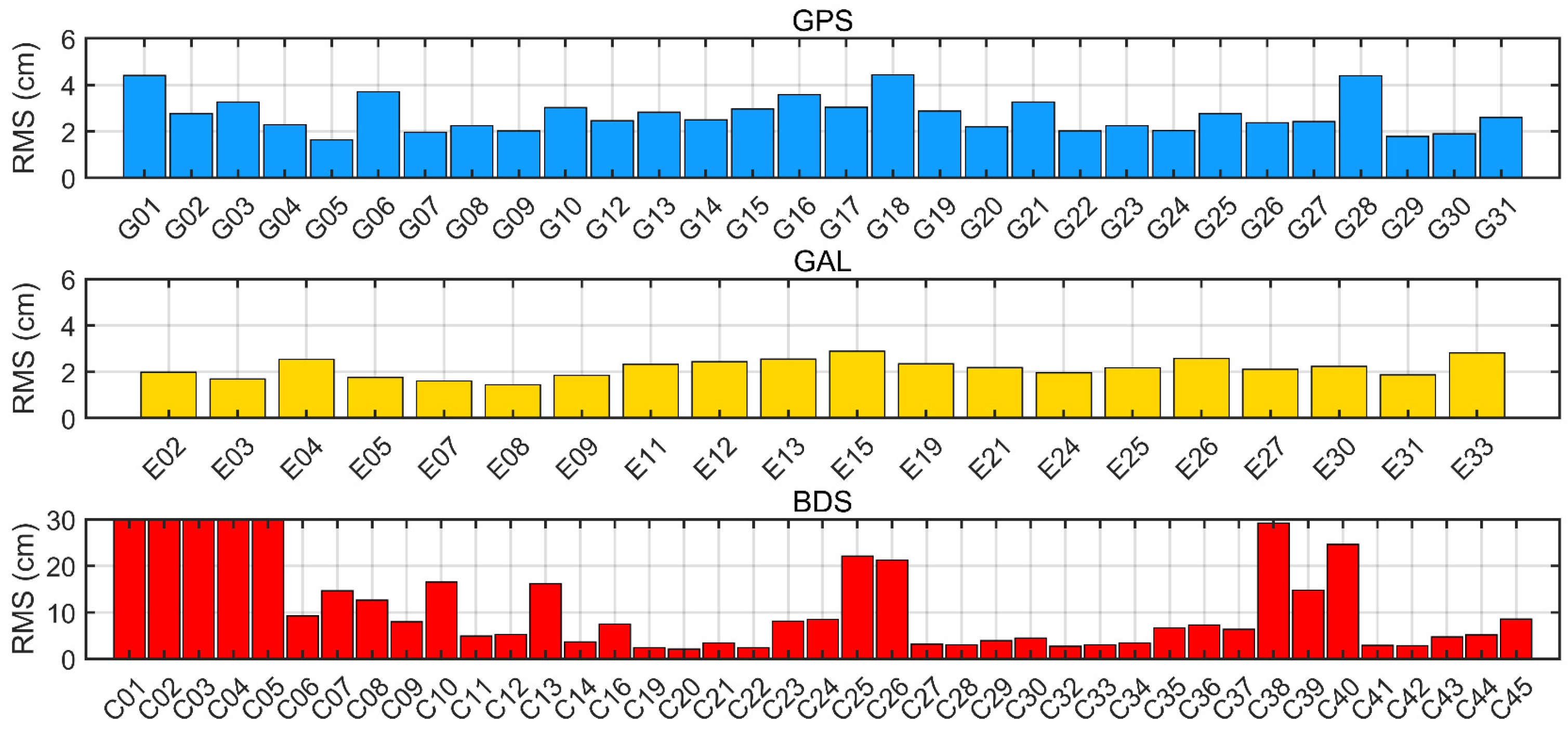
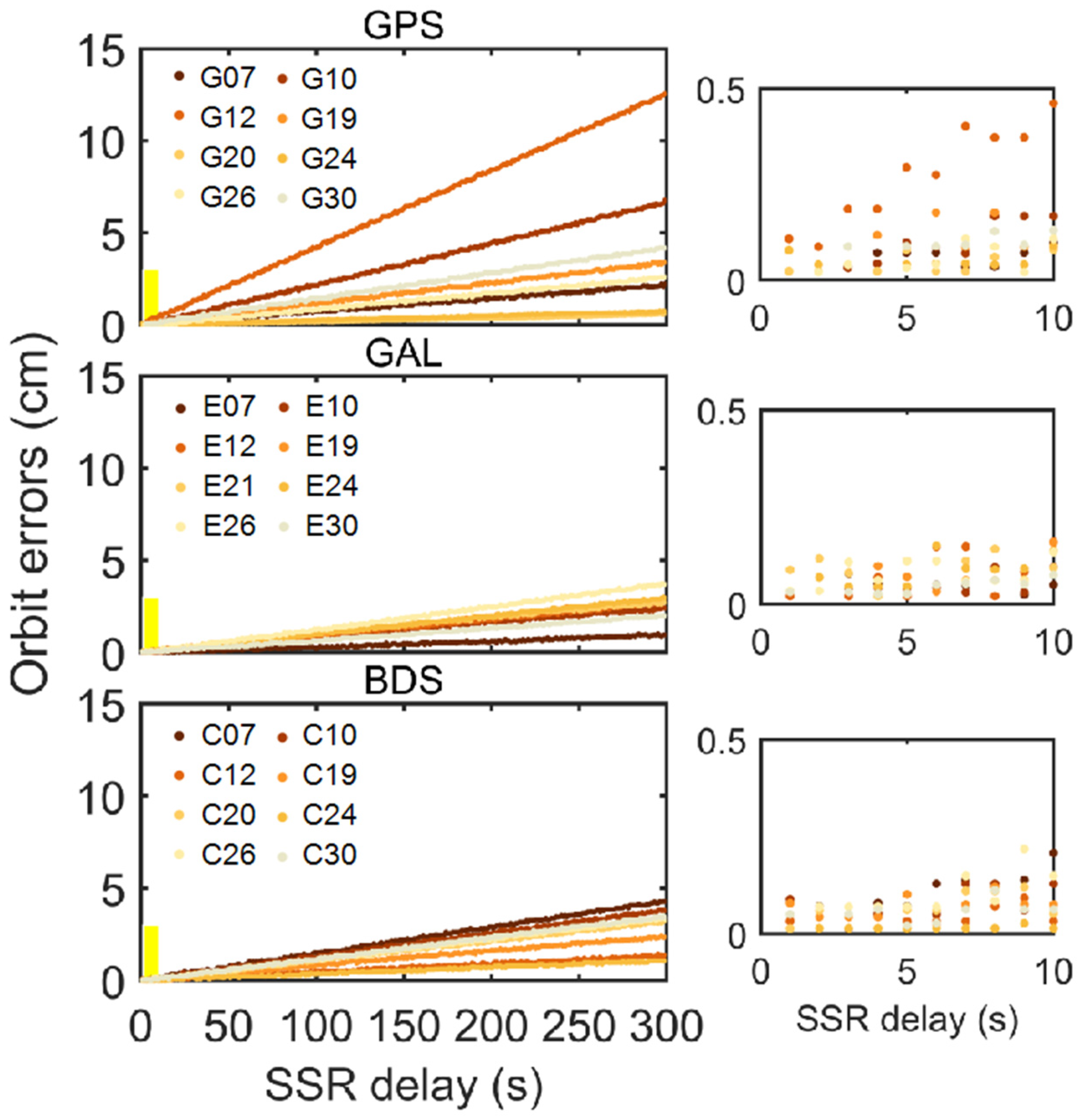
3.2. Accuracy Evaluation of Real-Time Orbit and Clock Products

In this section, the quality of CNES precise orbit and clock products was evaluated, and the extrapolation errors for GPS, BDS, and Galileo systems were analyzed by simulating real-time SSR delay. The calculated SISREs were used to optimize the stochastic model in the PPP and TDCP models, thereby improving positioning reliability.
During normal communication, the precision of RT products plays a pivotal role in influencing PPP-AR positioning performance. To evaluate the accuracy of CNES products, we used the post-precise products provided by Wuhan University as the reference. Figure 3 presents the average SISREs caused by clock and orbit errors for each satellite in three systems during DOY 121-127, 2022. GPS and Galileo RT products exhibit superior quality in comparison to BDS; the average SISREs for GPS, Galileo, and BDS systems are 2.7 cm, 2.2 cm, and 8.6 cm, respectively. Due to significant clock and orbit errors associated with GEO satellites, BDS GEO satellites were excluded from the calculation of average SISREs. It is evident that, except for the individual satellites of BDS, the precision of both clock offset and orbit among satellites within the same system is nearly identical. This consistency makes it possible to directly optimize the PPP stochastic model based on SISREs of three systems in the experiment.
Based on Equation (14) presented in Section 2.3, clock and orbit extrapolation errors for GPS, Galileo, and BDS were processed under 5 min delays. Figure 4 and Figure 5 display the SISRE resulting from clock and orbit extrapolation for each satellite in three systems, considering delays ranging from 1 to 300 s. As can be observed in Figure 4 and Figure 5, the extrapolation accuracy of clock and orbit products decreases as the SSR delay increases. It is noteworthy that the extrapolation error growth is of obvious variations among different systems, and the growth rate and trend for various satellites also differ significantly. Therefore, it is necessary to optimize the TDCP stochastic model based on the SISRE of each satellite in subsequent experiments. We also can see that clock extrapolation errors for Galileo and BDS are smaller than those for GPS, while the orbit extrapolation errors for all three systems exhibit similar characteristics. Additionally, the extent of variation remains minimal within the range of 1 to 10 s for extrapolation errors. Given that the CNES updates RT product information every 5 s, an SSR delay within 10 s can be negligible in terms of its impact. Consequently, this study sets 10 s as the threshold for switching to the TDCP positioning mode.
Figure 6 illustrates the average SISREs resulting from clock and orbit extrapolation with a 5 min delay for each satellite in the GPS, Galileo, and BDS systems during DOY 121-127, 2022. Galileo demonstrates better accuracy than the others. SISREs attributed to extrapolation within 5 min delay remain below 3 cm, except for E14 and E19. Different from the results caused by precise products themselves (Figure 3), GPS exhibits notably lower extrapolation accuracy compared to Galileo and BDS, with some satellites showing errors exceeding 4 cm. However, Block IIF-type satellites, including G01, G03, G06, G09, G10, G25, G26, G27, G30, and G32, consistently display smaller clock extrapolation errors due to their rubidium atomic clocks. Additionally, BDS-3 exhibits slightly higher extrapolation accuracy than BDS-2, likely attributed to the implementation of domestically produced rubidium and hydrogen atomic clocks, which enhance stability [37]. The average SISREs resulting from clock and orbit extrapolation under 5 min delay for GPS, Galileo, and BDS are 3.5 cm, 1.4 cm, and 2.6 cm, respectively.

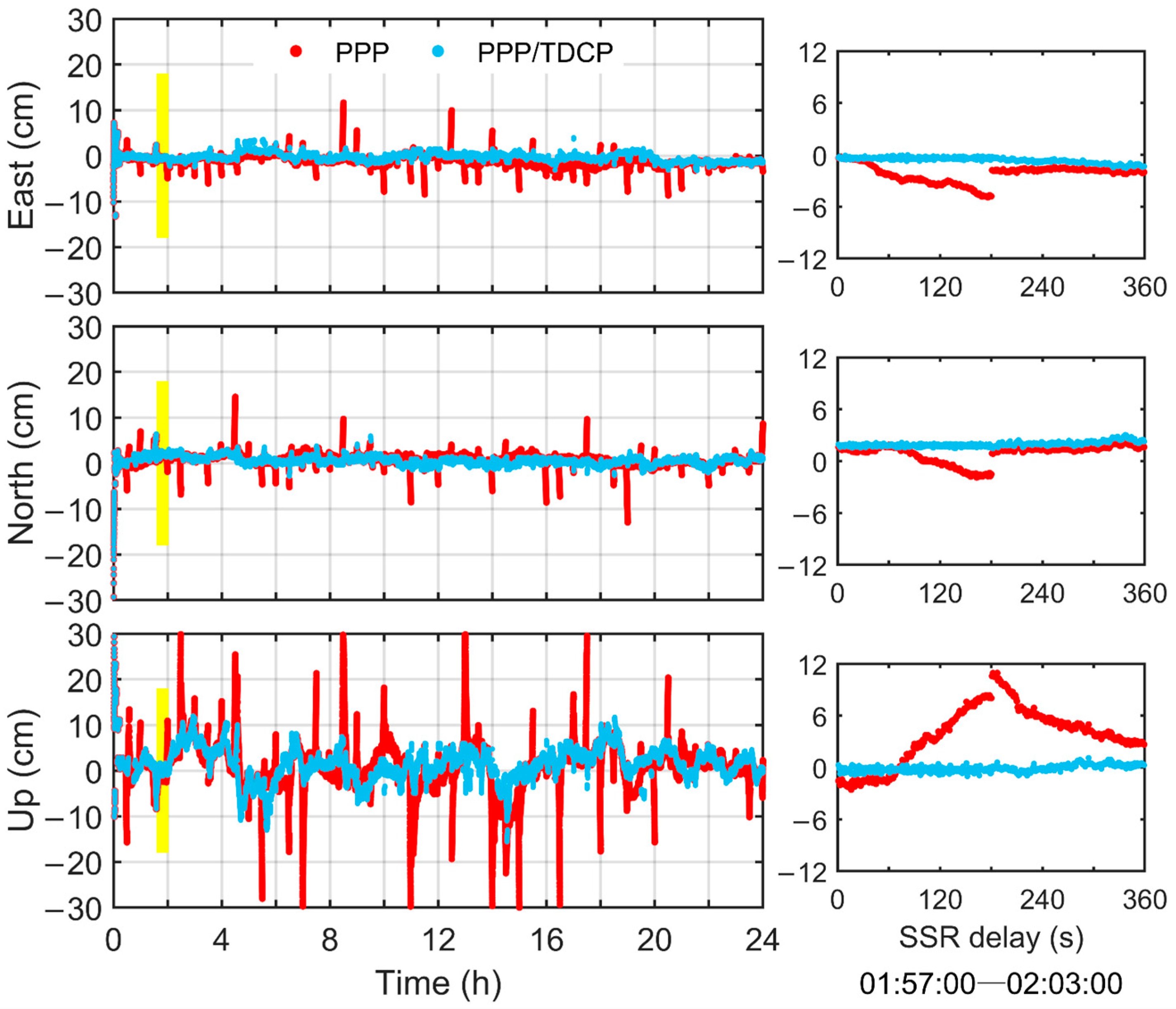
3.3. Performance Analysis of GPS/Galileo/BDS PPP-AR Considering SSR Delay

The combination of multiple GNSS systems offers substantial enhancements in time to first fixed (TTFF), AR positioning accuracy, and reliability [38,39]. Consequently, the fusion of GPS, Galileo, and BDS was adopted to validate the performance of the new method. By integrating SISREs into the stochastic model under normal communication and SSR delay for optimization, the positioning accuracy before and after optimization was compared. Subsequently, optimized models were utilized to verify the positioning accuracy of the new method.
In the normal case of communication, the PPP model is used, and the stochastic model is optimized based on SISREs calculated from the quality of precise products themselves in Section 3.2. Figure 7 illustrates GPS/BDS/Galileo PPP-AR positioning errors using the original and optimized stochastic model at the DYNG station. When the original stochastic model is utilized for positioning, floating point issues arise intermittently, with more pronounced effects observed in the up direction. After using the optimized stochastic model, stable fixed results can be obtained during these periods, effectively alleviating the negative impact on positioning accuracy caused by the low accuracy of individual satellite orbits and clocks. GPS/BDS/Galileo PPP-AR was conducted on 10 stations, with re-initialization occurring every two hours. Table 3 presents the mean TTFF and positioning accuracy of fixed solutions for these specific stations. The results unequivocally demonstrate that adopting the optimized stochastic model accelerates the convergence speed of solutions. Particularly, the reduction in TTFF from 21.5 min to 13.5 min for the BIK0 station is notable (8 min less). Moreover, the optimized stochastic model enhances the positioning accuracy of each station to varying degrees. The varying degrees of improvement among different stations are associated with their respective observational environments, observed satellites, and satellite geometrical configurations.
When the SSR delay exceeds a certain threshold, the TDCP model is used, and the stochastic model is optimized based on the extrapolated SISRE results in Section 3.2. Figure 8 illustrates the disparities in the RMS values in the horizontal and vertical directions when using the original and optimized stochastic models for the TDCP under various delay conditions. It becomes evident that an increase in SSR delay leads to a gradual reduction in the real-time accuracy of multi-GNSS. In Figure 8, it is apparent that when using the optimized stochastic model, the accuracy remains at approximately 0.7 cm horizontally and 5.0 cm vertically for delays up to 10 min. Compared to the original stochastic model, the accuracy has improved by 20% and 40% in the horizontal and vertical directions, respectively.
To highlight the advantages of multi-GNSS PPP aided by the TDCP method, we simulated multiple SSR delays of 30 s, 2 min, and 3 min for 24 h, respectively. We then compared the positioning performance of this approach with the traditional PPP-AR method, both utilizing the optimized stochastic model.
Figure 9, Figure 10 and Figure 11 illustrate the positioning errors of the traditional PPP and PPP/TDCP combined method under 30 s, 2 min, and 3 min SSR delays at the DYNG station. Since the experiment involved 24 h high-frequency data, we enlarged the results for double SSR delay epochs to facilitate a more comprehensive analysis of positioning stability during SSR delays and data transmission recovery. For a 30 s delay, the positioning results for both methods are generally comparable in most periods, with accuracy consistently maintained at a stable level. However, there are still some periods where the results of the traditional method exhibited dispersion phenomena (e.g., as shown in Figure 9, right). Both methods quickly achieve convergent positioning results after communication recovery. With a 2 min delay shown in Figure 10, the traditional method displays a sudden change in results during the delay period, with noticeable discontinuity. Using the TDCP model ensures positioning reliability during this period. In Figure 11, as the delay extends to 3 min, the new method consistently maintains better positioning performance, with errors of 0.8 cm and 2.7 cm in the horizontal and vertical directions, respectively, while the accuracy of the traditional method is up to 2.7 cm and 9.2 cm. The discontinuity of the articulation at the 2 min delay (as shown in Figure 10, right) compared to the 3 min delay may be related to the state of its inherited previous epoch parameters. With an increase in SSR delay, the new method achieves convergent results in a shorter time by utilizing previous filter state information during communication recovery compared to traditional PPP. The solutions of the traditional method experience varying degrees of accuracy loss in all three directions, with the pronounced dispersion up to 30 cm in some periods, while errors of the PPP/TDCP combined model can be maintained within 10 cm.
The above findings demonstrate that the new method effectively overcomes abnormal issues during SSR delay, ensuring that accuracy remains within a reliable range. Simultaneously, data from 10 stations were processed. Figure 12 presents the average RMS values of MGEX stations using the traditional PPP and PPP/TDCP combined method for all delay periods. It can be observed that the most significant improvement is evident with a 3 min delay. The average 3D accuracy for 10 stations using the traditional and new methods is 5.9 cm and 2.4 cm, respectively. The 3D positioning accuracy of the DYNG station increased from 5.7 cm to 1.7 cm, with a 70.2% enhancement. However, variations in positioning performance among different stations are observed, potentially influenced by factors such as the number of visible satellites, the constellation geometry, and the observation environment around the station.

4. Conclusions

In real-time positioning, PPP-AR heavily relies on correction information broadcast by the server; however, it frequently encounters SSR delays caused by communication anomalies. This study introduced the multi-GNSS PPP-AR aided with the TDCP method, which accounts for SSR delay. To maintain positioning stability and reliability during SSR delay, the TDCP was utilized for position extrapolation. Stochastic models for the PPP and TDCP were optimized based on the quality and extrapolation errors of RT products, and the performance of PPP-AR under SSR delay in the new method was analyzed. The experimental findings are summarized as follows:
(1)
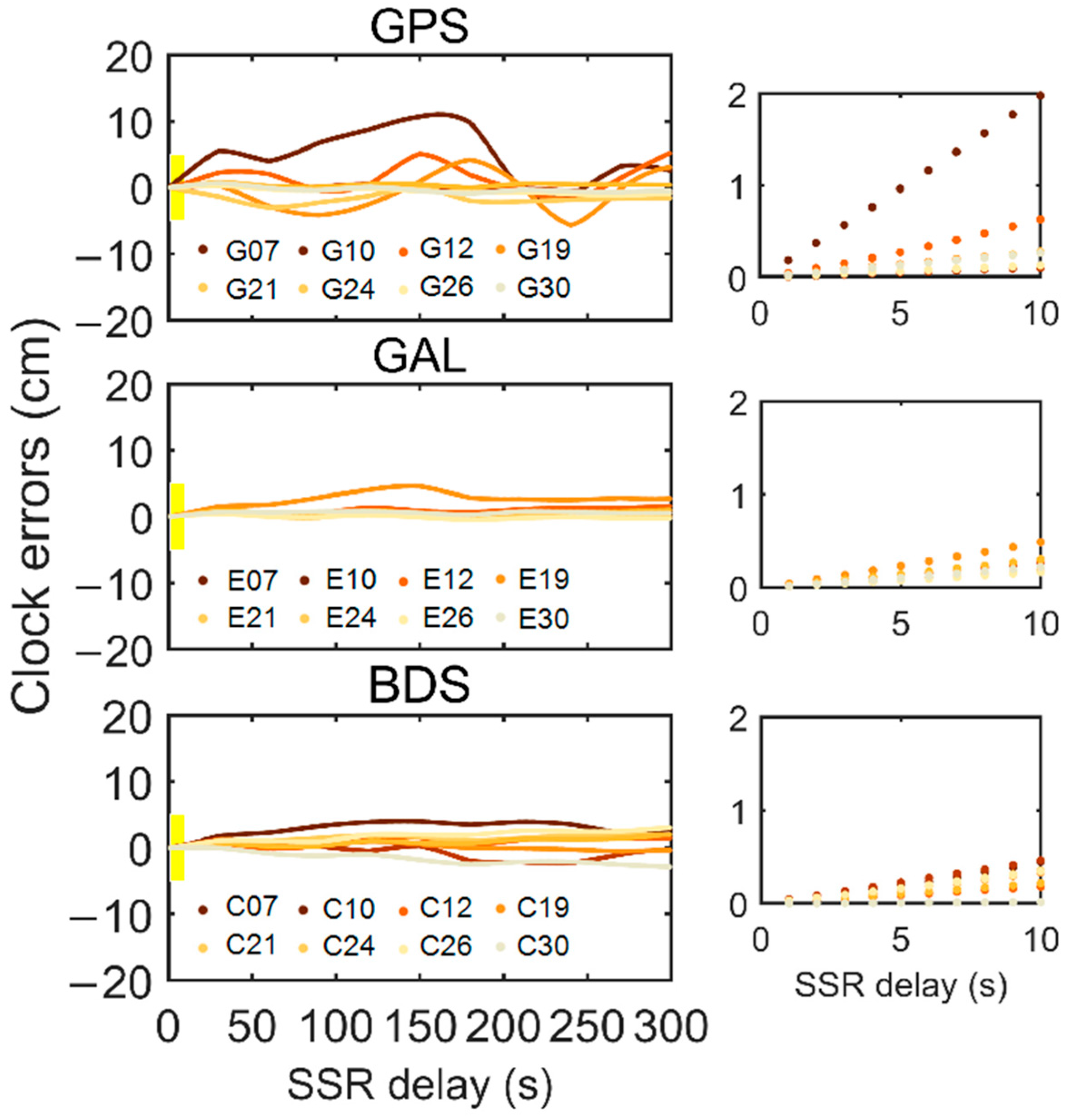
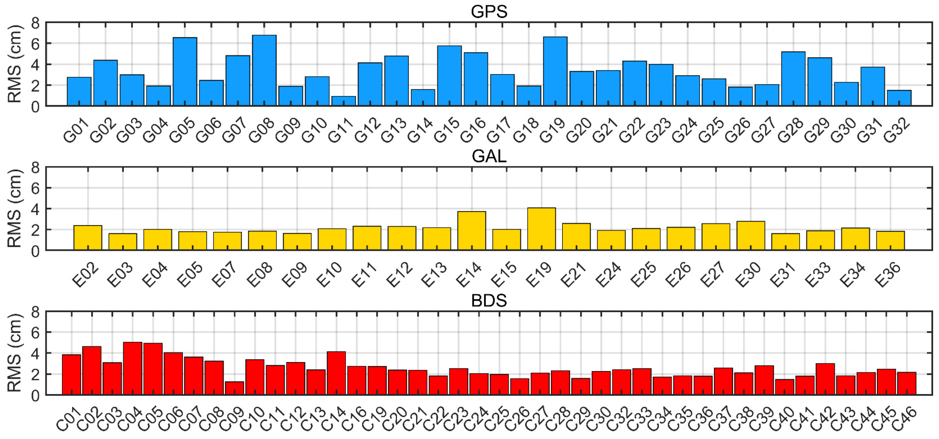
Both the accuracy of precise products themselves and their extrapolation errors vary widely across different systems. GPS and Galileo products demonstrate better accuracy with SISREs of 2.7 cm and 2.2 cm, which are smaller than that of BDS (8.6 cm). However, when the SSR delay occurs, the extrapolation errors for BDS and Galileo are smaller. The average SISREs from clock and orbit extrapolation for GPS, Galileo, and BDS are 3.5 cm, 1.4 cm, and 2.6 cm, respectively.
(2)
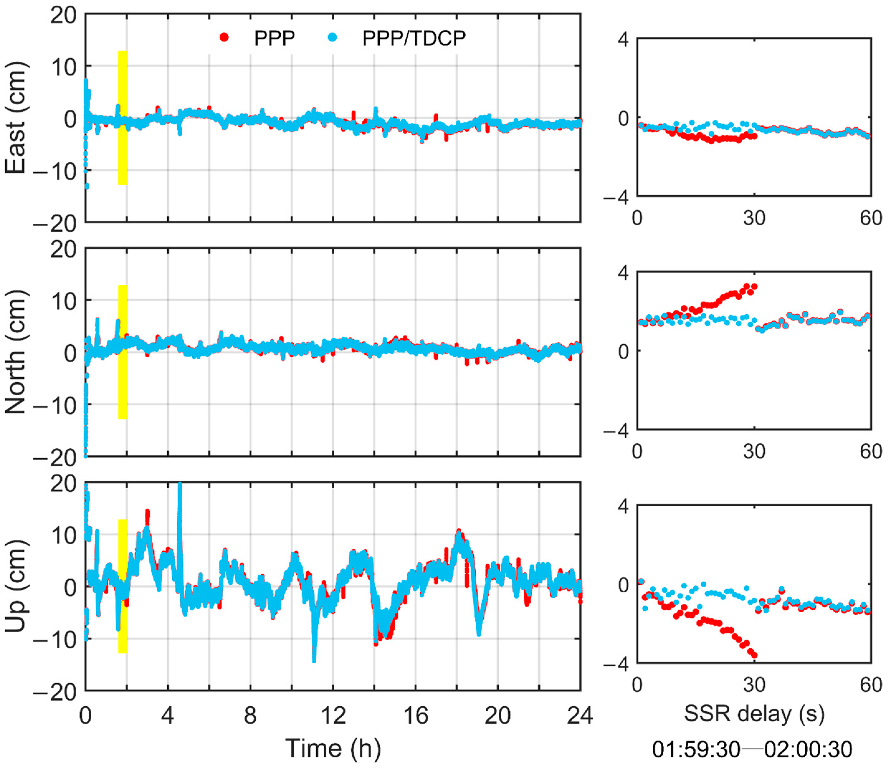
Optimizing the PPP stochastic model based on the accuracy of the products themselves can effectively shorten the PPP-AR convergence time and improve the fixed solution accuracy. By optimizing the TDCP stochastic model based on extrapolation errors, the accuracy under a 10 min delay is maintained at 0.7 cm and 5.0 cm in the horizontal and vertical directions, resulting in improvements of 61.1% and 37.5%, respectively. The multi-GNSS PPP-AR method with stochastic model optimization has the capability to acquire precise position information by utilizing the TDCP during SSR delay. With a 3 min SSR delay, the average 3D positioning accuracy of 10 stations can be improved from 5.9 cm to 2.4 cm using the TDCP, representing a 59.3% improvement. Furthermore, positioning results can swiftly converge after communication recovery. The method presented here effectively addresses the issue of anomalous positioning results caused by SSR delay due to unstable communication links in practical applications, thus avoiding re-convergence.

Author Contributions

X.M. conceived the idea and designed the experiments with B.S. and L.W. Data collection, processing, and analysis were performed by X.M., X.M., and L.W. and B.S. wrote the main manuscript. Y.T., X.L., T.L., G.H. and Q.Z. reviewed and revised the manuscript. All authors have read and agreed to the published version of the manuscript.

Funding

This work is funded by National Key R&D Program of China (2021YFC3000503), the National Natural Science Foundation of China (42004024; 42127802), the Fundamental Research Funds for the Central Universities, CHD (300102263202), the Shaanxi Province Science and Technology Innovation Team (Ref. 2021TD-51) and the innovation team of ShaanXi Provincial Tri-Qin Scholars with Geoscience Big Data and Geohazard Prevention (2022).

Data Availability Statement

The real-time orbit, clock, and OSB products are downloaded from the Centre National d’Etudes Spatiales (http://www.ppp-wizard.net/products/REAL_TIME/, accessed on 1 May 2023). The GNSS observations are available from the Crustal Dynamics Data Information System (https://cddis.nasa.gov/archive/gnss/data/, accessed on 1 May 2023). The station distribution map was plotted using Generic Mapping Tools version 6.2 (https://www.generic-mapping-tools.org, accessed on 15 June 2023).

Acknowledgments

We thank the GMT Developers for providing Generic Mapping Tools (GMTs). We thank the Centre National D’Etudes Spatiales (CNES) for providing the real-time orbit, clock, and OSB products. We thank the National Aeronautics and Space Administration (NASA) and the International GNSS Service (IGS) for providing the GNSS observation data.

Conflicts of Interest

The authors declare no conflicts of interest.

References

  1. Zhang, X.; Li, X.; Li, P. Review of GNSS PPP and its application. Acta Geod. Cartogr. Sin. 2017, 46, 1399–1407. [Google Scholar]
  2. Zhuang, W.; Li, J.; Hao, M.; Cui, D. Study on the characteristics of current crustal activity in the southern Sichuan-Yunnan block using dense GNSS data and focal mechanism solution. J. Geod. Geodyn. 2021, 41, 732–738+746. [Google Scholar]
  3. Zumberge, J.F.; Heflin, M.B.; Jefferson, D.C.; Watkins, M.M.; Webb, F.H. Precise point positioning for the efficient and robust analysis of GPS data from large networks. J. Geophys. Res. 1997, 102, 5005–5017. [Google Scholar] [CrossRef]
  4. Liu, T.; Yuan, Y.; Zhang, B.; Wang, N.; Tan, B.; Chen, Y. Multi-GNSS precise point positioning (MGPPP) using raw observations. J. Geod. 2017, 91, 253–268. [Google Scholar] [CrossRef]
  5. Li, X.; Ge, M.; Zhang, X.; Zhang, Y.; Guo, B.; Wang, R.; Klotz, J.; Wickert, J. Real-time high-rate co-seismic displacement from ambiguity-fixed precise point positioning: Application to earthquake early warning. Geophys. Res. Lett. 2013, 40, 295–300. [Google Scholar] [CrossRef]
  6. Li, X.; Ge, M.; Dai, X.; Ren, X.; Fritsche, M.; Wickert, J.; Schuh, H. Accuracy and reliability of multi-GNSS real-time precise positioning: GPS, GLONASS, BeiDou, and Galileo. J. Geod. 2015, 89, 607–635. [Google Scholar] [CrossRef]
  7. Hadas, T.; Bosy, J. IGS RTS precise orbits and clocks verification and quality degradation over time. GPS Solut. 2015, 19, 93–105. [Google Scholar] [CrossRef]
  8. Wang, Z.; Li, Z.; Wang, L.; Wang, X.; Yuan, H. Assessment of Multiple GNSS Real-Time SSR Products from Different Analysis Centers. IJGI ISPRS Int. J. Geo-Inf. 2018, 7, 85. [Google Scholar] [CrossRef]
  9. Yang, H.; Xu, C.; Gao, Y. Analysis of GPS satellite clock prediction performance with different update intervals and application to real-time PPP. Surv. Rev. 2019, 51, 43–52. [Google Scholar] [CrossRef]
  10. El-Mowafy, A.; Deo, M.; Kubo, N. Maintaining real-time precise point positioning during outages of orbit and clock corrections. GPS Solut. 2017, 21, 937–947. [Google Scholar] [CrossRef]
  11. El-Mowafy, A. Impact of predicting real-time clock corrections during their outages on precise point positioning. Surv. Rev. 2019, 51, 183–192. [Google Scholar] [CrossRef]
  12. Nie, Z.; Gao, Y.; Wang, Z.; Ji, S.; Yang, H. An approach to GPS clock prediction for real-time PPP during outages of RTS stream. GPS Solut. 2018, 22, 14. [Google Scholar] [CrossRef]
  13. Zhao, Q.; Gao, W.; Gao, C.; Pan, S.; Yang, X.; Wang, J. Comprehensive outage compensation of real-time orbit and clock corrections with broadcast ephemeris for ambiguity-fixed precise point positioning. Adv. Space Res. 2021, 67, 1124–1142. [Google Scholar] [CrossRef]
  14. Van, G.F.; Soloviev, A. Precise velocity estimation using a stand-alone GPS receiver. In Proceedings of the ION NTM 2003, Anaheim, CA, USA, 22–24 January 2003; pp. 283–292. [Google Scholar]
  15. Serrano, L.; Kim, D.; Langley, R.B. A single GPS receiver as a real-time, accurate velocity and acceleration sensor. In Proceedings of the ION GNSS 17th International Technical Meeting of the Satellite Division, Long Beach, CA, USA, 21–24 September 2004; pp. 2021–2034. [Google Scholar]
  16. Serrano, L.; Kim, D.; Langley, R.B.; Itani, K.; Ueno, M. A GPS velocity sensor: How accurate can it be?—A first look. In Proceedings of the ION NTM 2004, San Diego, CA, USA, 26–28 January 2004; pp. 875–885. [Google Scholar]
  17. Li, M.; Li, W.; Fang, R.; Shi, C.; Zhao, Q. Real-time high-precision earthquake monitoring using single-frequency GPS receivers. GPS Solut. 2015, 19, 27–35. [Google Scholar] [CrossRef]
  18. Geng, T.; Xie, X.; Fang, R.; Su, X.; Zhao, Q.; Liu, G.; Li, H.; Shi, C.; Liu, J. Real-time capture of seismic waves using high-rate multi-GNSS observations: Application to the 2015 Mw 7.8 Nepal earthquake. Geophys. Res. Lett. 2016, 43, 161–167. [Google Scholar] [CrossRef]
  19. Yu, W.; Ding, X.; Chen, W.; Dai, W.; Yi, Z.; Zhang, B. Precise point positioning with mixed use of time-differenced and undifferenced carrier phase from multiple GNSS. J. Geod. 2019, 93, 809–818. [Google Scholar] [CrossRef]
  20. Guo, F.; Li, X.; Zhang, X.; Wang, J. Assessment of precise orbit and clock products for Galileo, BeiDou, and QZSS from IGS Multi-GNSS Experiment (MGEX). GPS Solut. 2017, 21, 279–290. [Google Scholar] [CrossRef]
  21. Kouba, J.; Héroux, P. Precise Point Positioning Using IGS Orbit and Clock Products. GPS Solut. 2001, 5, 12–28. [Google Scholar] [CrossRef]
  22. Liu, X.; Jiang, W.; Li, P.; Deng, Z.; Ge, M.; Schuh, H. An extended inter-system biases model for multi-GNSS precise point positioning. Measurement 2023, 206, 112306. [Google Scholar] [CrossRef]
  23. Freda, P.; Angrisano, A.; Gaglione, S.; Troisi, S. Time-differenced carrier phases technique for precise GNSS velocity estimation. GPS Solut. 2015, 19, 335–341. [Google Scholar] [CrossRef]
  24. Choy, S.; Bisnath, S.; Rizos, C. Uncovering common misconceptions in GNSS Precise Point Positioning and its future prospect. GPS Solut. 2017, 21, 13–22. [Google Scholar] [CrossRef]
  25. Li, X.; Li, X.; Yuan, Y.; Zhang, K.; Zhang, X.; Wickert, J. Multi-GNSS phase delay estimation and PPP ambiguity resolution: GPS, BDS, GLONASS, Galileo. J. Geod. 2018, 92, 579–608. [Google Scholar] [CrossRef]
  26. Gerdan, G.P. A Comparison of Four Methods of Weighting Double Difference Pseudorange Measurements. Aust. Surv. 1995, 40, 60–66. [Google Scholar] [CrossRef]
  27. Zhang, L.; Yang, H.; Gao, Y.; Yao, Y.; Xu, C. Evaluation and analysis of real-time precise orbits and clocks products from different IGS analysis centers. Adv. Space Res. 2018, 61, 2942–2954. [Google Scholar] [CrossRef]
  28. Bahadur, B.; Nohutcu, M. Comparative analysis of MGEX products for post-processing multi-GNSS PPP. Measurement 2019, 145, 361–369. [Google Scholar] [CrossRef]
  29. Kazmierski, K.; Sośnica, K.; Hadas, T. Quality assessment of multi-GNSS orbits and clocks for real-time precise point positioning. GPS Solut. 2018, 22, 11. [Google Scholar] [CrossRef]
  30. Montenbruck, O.; Steigenberger, P.; Hauschild, A. Multi-GNSS signal-in-space range error assessment—Methodology and results. Adv. Space Res. 2018, 61, 3020–3038. [Google Scholar] [CrossRef]
  31. Wu, W.; Guo, F.; Zheng, J. Analysis of Galileo signal-in-space range error and positioning performance during 2015–2018. Satell. Navig. 2020, 1, 6. [Google Scholar] [CrossRef]
  32. Shu, B.; Liu, H.; Feng, Y.; Xu, L.; Qian, C.; Yang, Z. Analysis of Factors Affecting Asynchronous RTK Positioning with GNSS Signals. Remote Sens. 2019, 11, 1256. [Google Scholar] [CrossRef]
  33. Shu, B.; Wang, L.; Zhang, Q.; Huang, G. Evaluation of multi-GNSS orbit and clock extrapolating error and their influence on real-time PPP during outages of SSR correction. Acta Geod. Cartogr. Sin. 2021, 50, 1738–1750. [Google Scholar]
  34. Montenbruck, O.; Steigenberger, P.; Hauschild, A. Broadcast versus precise ephemerides: A multi-GNSS perspective. GPS Solut. 2015, 19, 321–333. [Google Scholar] [CrossRef]
  35. Robustelli, U.; Benassai, G.; Pugliano, G. Signal in Space Error and Ephemeris Validity Time Evaluation of Milena and Doresa Galileo Satellites. Sensors 2019, 19, 1786. [Google Scholar] [CrossRef] [PubMed]
  36. Dawidowicz, K. Igs08.atx to igs14.atx change dependent differences in a GNSS- derived position time series. Acta Geod. Cartogr. Sin. 2018, 15, 363–378. [Google Scholar] [CrossRef]
  37. Mao, Y.; Song, X.; Zhang, Q.; Ruan, R.; Wang, L. Performance evaluation and comparison of on-orbit satellite clocks for BDS-3. Acta Geod. Cartogr. Sin. 2023, 52, 349–356. [Google Scholar]
  38. Cai, C.; Gao, Y.; Pan, L.; Zhu, J. Precise point positioning with quad-constellations: GPS, BeiDou, GLONASS and Galileo. Adv. Space Res. 2015, 56, 133–143. [Google Scholar] [CrossRef]
  39. Guo, F.; Li, X.; Zhang, X.; Wang, J. The contribution of Multi-GNSS Experiment (MGEX) to precise point positioning. Adv. Space Res. 2017, 59, 2714–2725. [Google Scholar] [CrossRef]
Figure 1. Data processing flowchart of the real-time PPP-AR method considering SSR delay.
Remotesensing 16 01213 g001
Figure 2. Distribution of 10 selected MGEX stations in the PPP-AR experiments.
Remotesensing 16 01213 g002
Figure 3. The average SISREs caused by clock and orbit errors for GPS, Galileo, and BDS satellites during DOY 121-127, 2022.
Remotesensing 16 01213 g003
Figure 4. The SISREs for clock extrapolating under 1~300 s delay for each satellite in the GPS, Galileo, and BDS systems on DOY 121, 2022 (the right graphs show the variation in extrapolation errors from 1 s to 10 s for the highlighted sections shown in the left graphs, in the same units as the left graphs).
Remotesensing 16 01213 g004
Figure 5. The SISREs for orbit extrapolating under 1~300 s delay for each satellite in the GPS, Galileo, and BDS systems on DOY 121, 2022 (the right graphs show the variation in extrapolation errors from 1 s to 10 s for the highlighted sections shown in the left graphs, in the same units as the left graphs).
Remotesensing 16 01213 g005
Figure 6. The average SISREs for clock and orbit extrapolating under 5 min delay for each satellite in the GPS, Galileo, and BDS systems during DOY 121-127, 2022.
Remotesensing 16 01213 g006
Figure 7. The positioning errors for GPS/BDS/Galileo PPP-AR with the original and optimized stochastic model at DYNG on DOY 121, 2022.
Remotesensing 16 01213 g007
Figure 8. Positioning RMS errors in horizontal (h) and vertical (v) directions for the GPS/Galileo/BDS TDCP using the original (origin) and optimized (opt) stochastic model under different delays.
Remotesensing 16 01213 g008
Figure 9. Positioning errors at DYNG under multiple 30 s delays for 24 h on DOY 121, 2022, with different PPP approaches (the right graphs are the results for double SSR delay epochs, corresponding to the highlighted region in the left graphs, in the same units as the left graphs).
Remotesensing 16 01213 g009
Figure 10. Positioning errors at DYNG under multiple 2 min delays for 24 h on DOY 121, 2022, with different PPP approaches (the right graphs are the results for double SSR delay epochs, corresponding to the highlighted region in the left graphs, in the same units as the left graphs).
Remotesensing 16 01213 g010
Figure 11. Positioning errors at DYNG under multiple 3 min delays for 24 h on DOY 121, 2022, with different PPP approaches (the right graphs are the results for double SSR delay epochs, corresponding to the highlighted region in the left graphs, in the same units as the left graphs).
Remotesensing 16 01213 g011
Figure 12. Averaged RMSs of MGEX stations under multiple delays (30 s, 2 min, and 3 min) on DOY 121, 2022, with different approaches.
Remotesensing 16 01213 g012
Table 1. SISRE calculation coefficients for the statistical contribution of radial, along-track, and cross-track errors to the line-of-sight ranging error [32].
BDS
(GEO/IGSO)
BDS
(MEO)
GPSGalileo
α 0.990.980.980.98
β 127544961
Table 2. Processing strategies and data settings for PPP-AR.
ItemsDescription
GNSS systemsGPS, Galileo, and BDS
ObservationsIonosphere-free code and phase combinations
Elevation cutoff angle
Sampling interval1 s
Orbits and clocksReal-time products from the CNES
Code and phase biasesCorrected with the OSB products from the CNES
Observation weightEmpirical stochastic model based on precise products
PCO/PCVCorrected with IGS14.atx [36]
Ionospheric delayEliminated by ionosphere-free combinations
Tropospheric delayThe wet component was estimated as a random-walk process
Phase ambiguityEstimated as a constant for each ambiguity arc
Bootstrapping success rate0.99
Ratio2.0
Table 3. TTFF and positioning accuracy for GPS/BDS/Galileo PPP-AR using the original and optimized stochastic model under no SSR delay.
StationOriginal Stochastic ModelOptimized Stochastic Model
TTFF/EpochAccuracy/cmTTFF/EpochAccuracy/cm
HorizontalVerticalHorizontalVertical
DYNG5821.03.94140.83.6
YEL23651.03.03301.02.8
GODE5371.23.35321.23.0
KIRU8381.23.68130.93.6
NKLG5081.74.24711.63.9
BIK012891.63.38091.42.9
SEYG4571.64.73991.54.6
ABPO8561.64.56851.44.3
MIZU4624.04.64334.04.3
KAT15132.04.54291.94.5
Disclaimer/Publisher’s Note: The statements, opinions and data contained in all publications are solely those of the individual author(s) and contributor(s) and not of MDPI and/or the editor(s). MDPI and/or the editor(s) disclaim responsibility for any injury to people or property resulting from any ideas, methods, instructions or products referred to in the content.

