1. Introduction
Aerosols refer to the collective term for solid and liquid (cloud) particles suspended in the atmosphere. Atmospheric aerosols are mainly distributed in the troposphere, with the majority concentrated in the boundary layer and diameters ranging from 0.001 to 100 μm. The atmospheric aerosol [
1], influencing climate variations through radiative forcing, results in atmospheric environmental pollution. This phenomenon not only affects human health [
2] and well-being but also poses significant challenges to societal development, attracting widespread attention [
3]. On the one hand, certain solid particles can remain suspended near the ground and, when inhaled during human respiration, may enter the lungs. The presence of viruses carried by these solid particles poses the potential risk of respiratory infections and may even contribute to the development of lung cancer. On the other hand, atmospheric aerosol pollution is a significant factor contributing to the occurrence of dust storms and haze weather [
4,
5,
6,
7]. This pollution exerts substantial pressure on transportation systems. Aerosols possess the ability to scatter, absorb, and transmit both solar and terrestrial radiation. Scattering induces the deflection and dispersion of light in the atmosphere, impacting its transparency, optical thickness, and energy balance, consequently influencing radiative transfer, atmospheric temperature, and the water cycle. Moreover, aerosols can serve as cloud condensation nuclei, promoting cloud formation and growth. This alteration affects the optical thickness and brightness of clouds, subsequently impacting their radiative properties and the overall atmospheric radiation balance. Furthermore, aerosols can influence the quantity and size of cloud droplets, thereby influencing cloud precipitation processes and the spatial-temporal distribution of precipitation, ultimately impacting the surface water cycle. Dust represents a prominent aerosol type in the atmosphere, and its optical properties hold significant implications for various aspects including the atmospheric energy balance, climate change, air quality, and weather forecasting. A thorough comprehension of the optical characteristics of sand and dust is crucial for enhancing our understanding of their transport, dispersion, and deposition mechanisms in the atmosphere. This understanding, in turn, contributes to improved accuracy in monitoring and predicting sand and dust storms, assessing their environmental and public health impacts, refining climate models, and thereby enhancing climate prediction and environmental protection strategies.
Extreme events such as dust storms and haze have profound effects on normal human activities [
8,
9]. Dust storms, characterized by their extremity and adverse meteorological nature, have been enduring subjects of scholarly scrutiny. Simultaneously, scholars employ diverse scientific methodologies to scrutinize dust storms, encompassing the utilization of observational and model data from the vantage point of atmospheric dynamics to elucidate the genesis of dust [
10], analyzing the distribution, transport, and ramifications on air quality through the integration of satellite data and models [
11,
12], and exploring the vertical diffusion of long-distance dust transport by amalgamating perspectives on atmospheric turbulence with regional dust enhancement observational data [
13]. For this dust event, numerous researchers have employed various approaches for comparative validation to collectively unveil the source, transport, and development trends of the dust storm. Filonchyk, M et al. [
14] analyzed data from ground-based sensors, satellites, and atmospheric models to conclude that the dust event affected not only the source area but also a wider territory. He, Yun et al. [
15] integrated space-based and ground-based observations to elucidate the horizontal distribution of the dust storm, its transport paths, dissipation, and its impact on surface air quality. Gui, Ke et al. [
16] characterized the optical, microphysical, and radiative properties of dust aerosols and their meteorological drivers using sun photometer observations and a comprehensive set of multi-satellite (including MODIS, VIIRS, CALIOP, and Himawari-8) and ground-based observations (including CMA Visibility Network and AD-Net) combined with atmospheric reanalysis data. Liang, Peng et al. [
17] conducted isotope analysis of fresh dust from various locations in the dust storm area and combined satellite images with real-time meteorological data to quantify the source of the dust storm.
Currently, air quality monitoring in major Chinese cities primarily relies on ground-level air quality monitoring stations [
18,
19]. However, due to the limited sampling range of these ground-level stations, they can only acquire one-dimensional time series array information near the ground, and their distribution is constrained. Additionally, these air quality stations cannot provide comprehensive coverage for certain regions, resulting in blind spots when monitoring air quality over larger areas. Therefore, relying solely on data from ground monitoring stations makes it challenging to fully comprehend the overall trend of air quality changes.
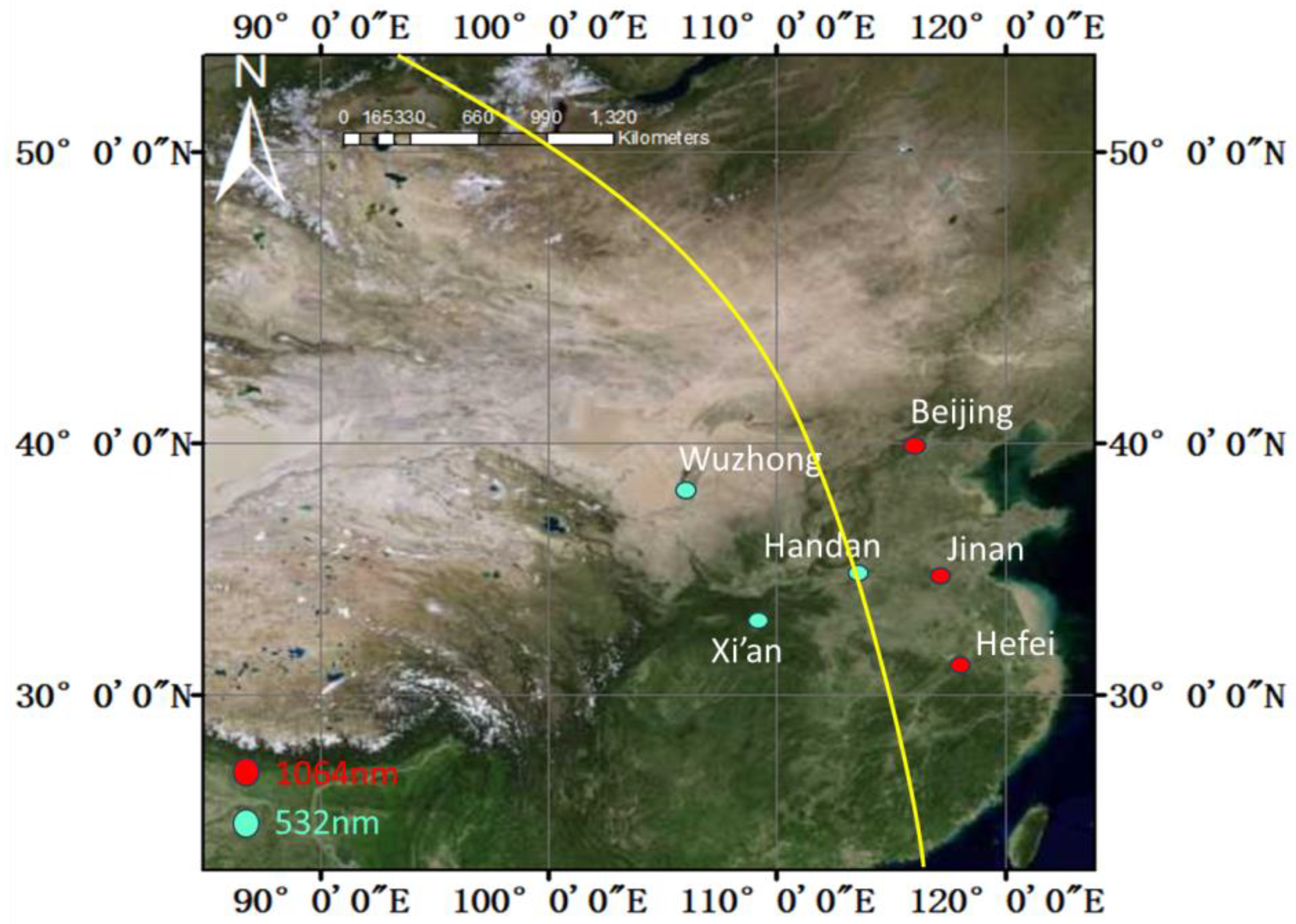
Lidar [
20], owing to its heightened sensitivity, precise temporal resolution, robust coherence, superior directionality, and its ability to capture and quantify target information in three-dimensional space [
21,
22], finds wide-ranging applications in atmospheric structure detection and environmental pollution monitoring [
23,
24,
25,
26]. Currently, aerosol Lidars are capable of effecting three-dimensional detection of cloud and aerosol, adeptly meeting the observational requisites for aerosol spatiotemporal evolution in confined spatial scales. Dust storms represent the spatial and temporal evolution of dust aerosols on a large scale. While aerosol Lidar can monitor aerosols in three dimensions and the polarization channel can identify dust aerosol from other aerosol species, these capabilities are primarily suited for monitoring aerosol evolution on small scales. In the case of large-scale aerosol cross-border transport, such as during dust storms, a single Lidar is insufficient for comprehensive monitoring, making it challenging to discern the aerosol transport patterns. Therefore, a network of aerosol Lidar-based observations is beneficial for elucidating the sources, types, transport, and development of sand and dust aerosols. Ground-based Lidar networks, concomitant with ground-level air quality monitoring data, satellite payload data, and spaceborne Lidar data, can proficiently delve into the three-dimensional spatial and temporal characteristics of aerosol transport. This approach unveils the origins, transport dynamics, and developmental trends of pertinent aerosols. Prominent Lidar observation networks comprise EARLINET, NDACC, AD-NET, MPLNET, LALINET, GALION [
27,
28,
29,
30,
31,
32,
33], and others. Many scholars have successfully integrated Lidar observation networks with studies on dust, yielding promising results. A. Ansmann et al. [
34] conducted an analysis of the mass distribution of dust and fine particulate matter in central Europe following the eruption of the Eyjafjallajökull volcano in Iceland. They utilized observations from the European Lidar Network (EARLINET), thereby providing valuable insights into the spatial distribution and transport processes of volcanic ash and dust. Jeffrey S. Reid et al. [
35] conducted an analysis of Saharan dust measurements during the Puerto Rico Dust Experiment (PRDEX) utilizing airborne and ground-based remote sensing methods. This study involved the use of Navajo aircraft, AERONET sun photometer data, and MPLNET Lidar data to elucidate the vertical distribution characteristics and transport processes of the dust. Tomoaki Nishizawa et al. [
36] introduced multi-wavelength Raman Lidar and High Spectral Resolution Lidar (HSRL) technologies to enhance the investigation of the optical and microphysical properties, as well as the motion mechanisms, of sand, dust, and air pollution aerosols in Asia. They also plan to utilize AD-NET for validation and data assimilation of Earth CARE satellite observations, aiming to evaluate air pollution and sand and dust aerosol emissions in East Asia.
The solar photometer operates independently of direct contact with sand and dust, rendering it unaffected by variables such as particle size and shape. Consequently, it can maintain stable operation over extended periods during dust studies, minimizing maintenance expenses and experimental inaccuracies. Unfortunately, the absence of data from these six sites in AERONET and SONET precludes more robust comparative observations.
Given the recurrent incidence of dust storms in northern China during spring, this study is centered around a substantial dust storm event that unfolded in the northern region of China from 14 to 16 March 2021. This paper offers a comprehensive analysis of the dust event by leveraging Lidar network observations and satellite remote sensing data. The Lidar network furnishes detailed characteristics of the dust, including species and concentration. Meanwhile, satellite data provides remote sensing attributes of the dust, such as coverage area and optical thickness of the dust cloud. By integrating these two datasets, researchers can conduct multi-scale monitoring of sand and dust, spanning from local to global scales. This approach facilitates a more comprehensive understanding of the spatial distribution and temporal variation of sand and dust phenomena.
The remaining sections of this article are as follows: In
Section 2, we will introduce the data, dust source tracing model, and specific technical solutions captured by various instruments and equipment on multiple platforms during this intense sand and dust event.
Section 3 focuses on the data processing of information collected from multiple platforms and the comprehensive analysis of data products.
Section 4 shows a summary of the conclusions.
3. Results and Discussion
3.1. Overview of Haze Pollution in China from 14 to 19 March 2021
From the night of 14 March to the morning of 16 March (Beijing time), extensive sandstorms swept through the most northern regions of China, influenced by a cyclone from Mongolia and cold air. This marked a significant sandstorm event, the most notable in the past decade [
54], leading to widespread haze pollution covering large parts of China. The impact was particularly felt in the northern, central, and eastern regions, significantly affecting air quality.
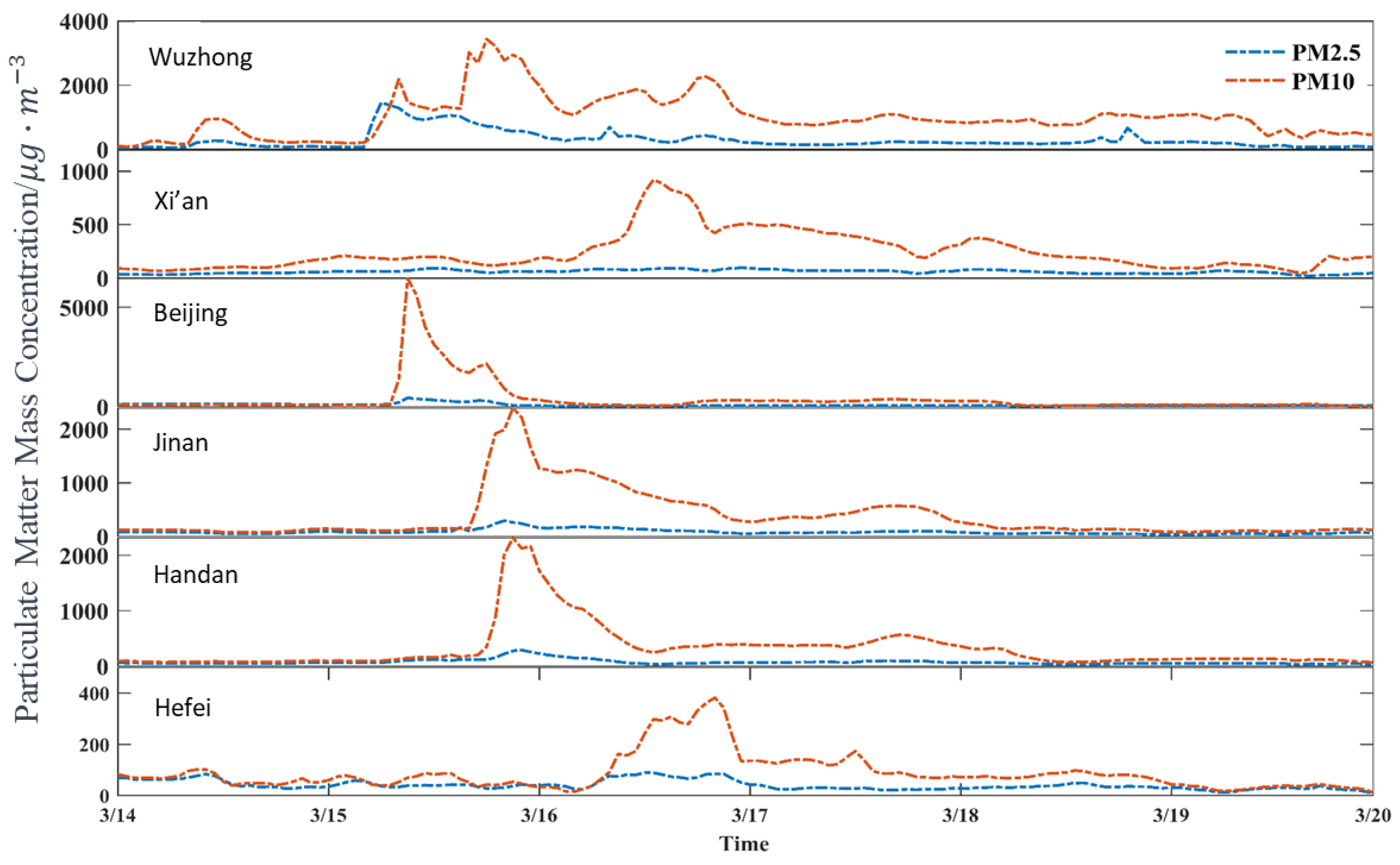
Figure 2 illustrates the variation in particle concentrations in cities where the observation sites of the Lidar network are located. The concentration trends of PM2.5 and PM10 at six sites shows remarkable consistency. In Beijing, Jinan, Handan, and Hefei, the PM2.5 concentrations were 401 μg/m
3, 292 μg/m
3, 277 μg/m
3, and 89 μg/m
3, respectively. The corresponding PM10 concentrations were 6450 μg/m
3, 2397 μg/m
3, 2315 μg/m
3, and 382 μg/m
3. The PM2.5/PM10 ratios were all less than 0.2 (except for Hefei), indicating that fine particulate matter constituted a small proportion during this sandstorm event, with coarse particles being predominant. At the Wuzhong observation site, there was a brief increase in PM2.5 and PM10 concentrations from 9:00 to 12:00 on 14 March. From 4:00 on 15 March, PM2.5 and PM10 concentrations began to sharply increase simultaneously. PM2.5 reached its peak at 1454 μg/m
3, and PM10 reached its first peak concentration of 2185 μg/m
3 at 8:00. Subsequently, both concentrations experienced a certain decrease. At 15:00, PM10 sharply increased again, reaching a peak concentration of 3435 μg/m
3 and maintaining a high concentration level for the next few days. On 15 March, as the sand dust arrived in Wuzhong and Beijing, there was no significant increase in PM2.5 and PM10 concentrations at the Xi’an site. Instead, PM10 concentrations began to gradually increase on 16 March, while PM2.5 concentrations remained relatively stable. Intense sand dust began to affect Beijing at 8:00 on 15 March, causing PM10 mass concentrations to soar to 6450 μg/m
3. The extremely high PM10 concentrations were of short duration and returned to pre-sandstorm levels by 16 March. In Jinan and Handan, around 16:00 on 15 March, PM10 mass concentrations rapidly increased to 2397 μg/m
3 and 2315 μg/m
3, respectively. The period of high concentration was brief, gradually decreasing to normal levels afterward. Due to its distance from the northern sand source, Hefei experienced minimal growth in particle mass concentrations during this sandstorm event. Around 6:00 on 16 March, PM10 concentrations began to gradually increase to 382 μg/m
3, and there was a slight increase in PM2.5 concentrations, but the amplitude was not significant. Hefei was less affected during this sandstorm event compared to other cities, with Beijing experiencing the greatest impact on air quality and Wuzhong having the longest duration of impact.
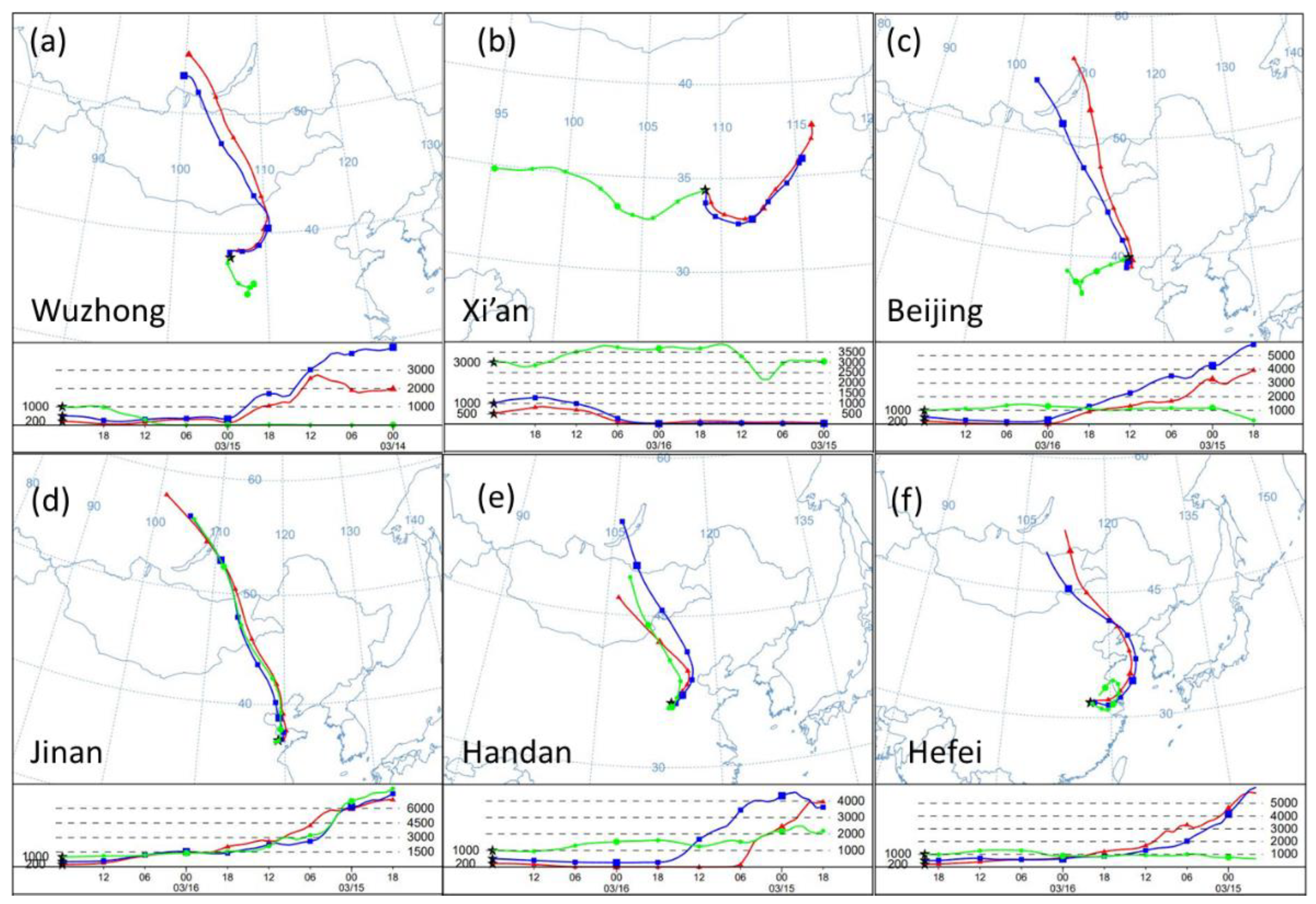
3.2. HYSPLIT Backward Trajectory and Dust Source Analysis
The primary conditions for the genesis of dust storms involve sand sources, robust winds, and thermally unstable atmospheric stratification. Northwestern China hosts numerous desert and desertification regions, such as deserts and the Gobi, characterized by soft surfaces, extensive exposure, and sparse vegetation. Consequently, these areas emerge as pivotal sources of dust storms during the autumn and winter seasons, with the predominant dust storm migration routes aligning westward, northwestward, and northward [
55]. As illustrated in
Figure 3, to ascertain the origin of dust, the HYSPLIT model was employed to scrutinize the backward trajectories of dust at six Lidar network sites across varied altitudes. Vertical profiles of dust at these six sites are discernible from
Figure 4. Intense dust at the Wuzhong, Beijing, Jinan, Handan, and Hefei sites predominantly concentrate below 1500 m, while in Xi’an, it is confined below 3000 m. Accordingly, trajectory analysis was executed at heights of 3000 m, 1000 m, and 500 m for Xi’an and at heights of 1000 m, 500 m, and 200 m for the other five sites.
In
Figure 3a, the backward trajectory of Wuzhong city delineates that the 1000 m high-altitude dust aerosol particle layer traverses Wuzhong from the southeast, distinctly differing from the dust sources at the other two altitudes. The 1000 m high-altitude dust aerosol particle layer, owing to its relatively abbreviated trajectory and gradual elevation, is inferred to have originated from the southeast direction, having resided there before 15 March, gradually dispersing to higher altitudes, and reaching an altitude of approximately 1000 m by 16 March upon arrival at Wuzhong. Hence, the 1000 m high-altitude dust in Wuzhong during this severe dust storm emanated from the southeast direction. The 500 m and 200 m low-altitude dust aerosol particle layers entered Wuzhong from Mongolia’s 2000–5000 m altitude in a northeast direction, gradually descending into the lower atmosphere along with high-pressure airflow and local urban aerosol particles. This phenomenon aligns with the non-spherical characteristics of dust measured by the Lidar network. In summary, the high-altitude dust during this severe dust storm in Wuzhong originated from the southeast direction, while the low-altitude dust derived from the deserts and Gobi regions of Inner Mongolia and Mongolia.
Figure 3b depicts the backward trajectory of Xi’an, revealing that the dust aerosol particle layers at three different altitudes originated from diverse locations. Considering geographical location, it is deduced that the 3000 m high-altitude dust aerosol particle layer originated from the Qaidam Desert in the west, undergoing protracted transport and descending from 3000 to 5000 m altitude to the ground in Xi’an by 15 March. The 500 m and 1000 m dust aerosol particle layers primarily originated from Henan and Shandong. Over time, the dust aerosol particle layers descended after settling and then ascended. Therefore, the intense dust weather in Xi’an during this period mainly originated from the dust in the Qaidam Desert, with additional contributions from land-based aerosol particles from Henan and Shandong.
In
Figure 3c, the backward trajectory of Beijing indicates that the 1000 m high-altitude dust aerosol particle layer originated from the southwest of Beijing, remaining stable at around 1000 m altitude during transportation to Beijing, gradually descending to the ground. The 500 m and 200 m dust aerosol particle layers cover a long and wide area trajectory, signifying robust winds, high wind speeds, and substantial pressure differences in the low-altitude dust aerosol particle layer, engendering favorable diffusion conditions. The low-altitude dust aerosol particle layer primarily originated from the dust at 4000–6000 m altitude in Mongolia, gradually spreading and settling in the lower atmosphere after long-distance transport. In conclusion, during this severe dust storm in Beijing, the high-altitude dust aerosol particle layer primarily originated from the southwest of Beijing, while the low-altitude dust aerosol particle layer mainly originated from the deserts and Gobi regions of Inner Mongolia and Mongolia.
Figure 3d–f, respectively, depict the backward trajectories of Jinan, Handan, and Hefei. At these three altitudes, the dust aerosol particle layers of the three cities predominantly traverse in a south-east direction, with relatively protracted backward trajectories. Consequently, it can be inferred that the dust aerosol particle layers in these three cities originated from the high-altitude dust aerosol layer in the central and eastern parts of Inner Mongolia and the eastern part of Mongolia. Jinan and Hefei exhibit a segment of the dust trajectory over the ocean, while Handan’s dust trajectory is entirely over land. Owing to the greater distance of the dust from Hefei, the intensity of the dust when it passes over Hefei is weaker compared to Jinan and Handan.
By analyzing the backward trajectories from six Lidar stations located in Wu Zhong, Xi’an, Beijing, Jinan, Handan, and Hefei, we successfully predicted the origin of this severe sandstorm weather. The predominant source of the intense sandstorm is still the sparsely vegetated deserts in the northwest of China, encompassing the Gobi Desert in the northern region of Inner Mongolia and the southern part of Mongolia. The backward trajectory paths from these six stations all revealed severe sandstorm weather of varying intensities, originating from different dust sources at various altitudes. The primary transmission routes predominantly lie in the northern and northwestern directions.
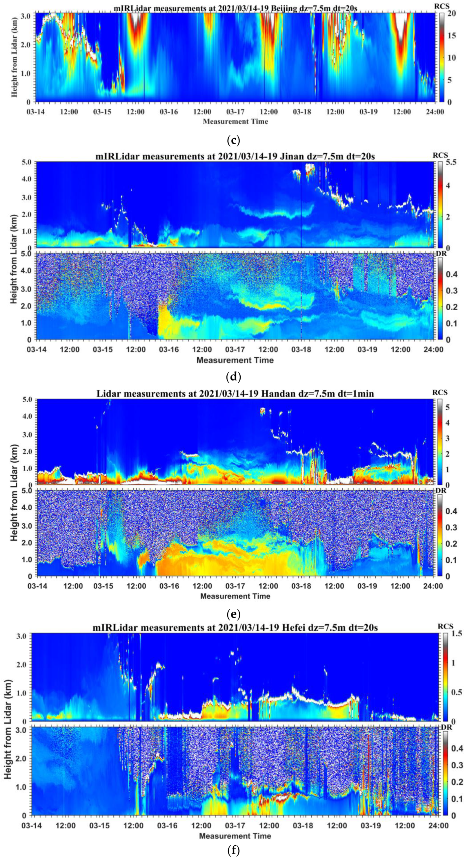
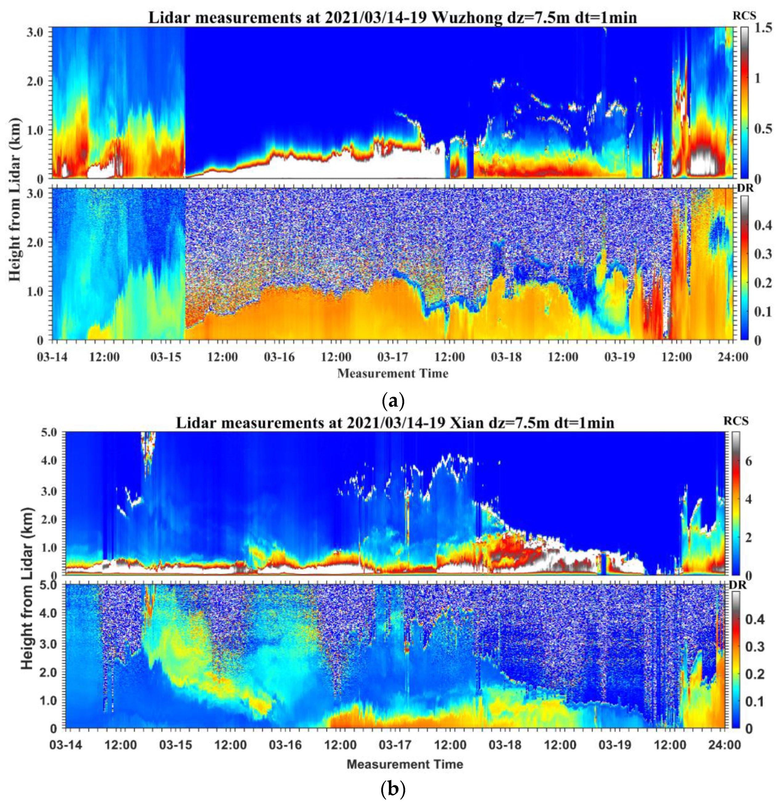
3.3. Lidar Observation Network Detects Sandstorm Processes
The comprehensive observation network of ground-based aerosol Lidar captured the entire process of this dust weather event. The range corrected signal (RCS) of the Lidar can reflect changes in atmospheric aerosol concentration [
56], providing an intuitive description of the sandstorm transit process. The non-spherical nature of dust particles results in a relatively large linear depolarization ratio, making it a useful parameter for identifying dust aerosols [
57].
Figure 4 presents each station and the the top panel is the range-corrected signal (RCS) in arbitrary units and the bottom panel (except for Beijing, because the APD of the parallel detection channel of the Lidar in Beijing was damaged during this dust process resulting in missing data, and thus the depolarization ratio of the Beijing area is not reflected) is the vertical depolarization ratio and the
X-axis shows the universal time.
The RCS from the Wuzhong station Lidar reveals elevated aerosol concentrations from 0:00 on 14 March 2021, at 0–1.7 km, with a depolarization ratio ranging from approximately 0.12 to 0.2, primarily attributed to local urban spherical aerosol particles. After 5:00 on 15 March, the Lidar captures sand and dust, the RCS suddenly increases, and the detection range plummets to 0.3 km. The depolarization ratio also increased to around 0.3 and persisted until the 19th indicating the dust transit during these days. According to the RCS, after 12:00 on 17 March, the signal weakened, and dust concentration began to decrease, primarily below 1 km. By around 22:00 on 18 March, the dust gradually dispersed, forming a layer between 0.2 km and 1 km, subsequently rising to approximately 2 km. Over time, around 16:00 on 19 March, the dust gradually dispersed to 0.5 km, finally disappearing near the ground.
The RCS from the Xi’an station Lidar indicates dust distribution around 16:00 on 14 March; sand dust was distributed between 2.3 km and 5 km. The dust gradually settles to the ground over time and spreads in the process. By around 22:00 on 15 March, the dust had weakened considerably, and the depolarization ratio decreased from 0.36 to 0.12. According to data, the dust entered Xi’an around 4:00 on 16 March, with a sudden increase in the depolarization ratio to around 0.3, persisting until around 16:00 on 18 March. Considering the timing of dust transit in Xi’an and the geographical location of the Xi’an station, it is evident that the dust from 16 March to 18 March is from a different source.
Based on the Lidar detection data in Beijing, the dust storm entered around 8:00 on 15 March. Due to Beijing’s higher latitude compared to Wuzhong, the arrival time of this dust storm was slightly later. Before the dust storm entered, the aerosol concentration near the ground in the Beijing area was low. At 8:00 on 15 March, the dust storm entered, sharply increasing the RCS until around 0:00 on 16 March, when the dust concentration returned to pre-arrival levels. The intense dust storm lasted roughly 18 h.
According to Lidar detection data in Jinan and Handan, the dust entered almost simultaneously, affecting both cities. On 14 March, low aerosol concentrations were observed below 1 km in the sky over Jinan, and aerosols from 1.1 km to the ground were observed over Handan. The depolarization ratio in both places was around 0.1. Typically, fine spherical particles (such as water droplets, ice crystals, etc.) exhibit a relatively low depolarization, close to 0, while coarse mineral particles (like sand, dust, etc.) display a relatively high depolarization, close to 1. A depolarization ratio of approximately 0.1 suggests that the scattering particles observed by Lidar may comprise a mixture of fine spherical particles and coarse mineral particles. This occurs because a depolarization ratio between 0 and 1 indicates that the scattered particles possess some non-spherical characteristics but are not exclusively composed of coarse mineral particles. Thus, when the depolarization ratio is around 0.1, it can be inferred that the observed particles constitute a complex mixture of particles with various shapes and sizes, potentially including a mixture of fine spherical particles along with coarse mineral particles. From 16:00 on 15 March, the dust began to transit in Jinan, with the dust aerosol height at about 2 km, and the depolarization ratio at 0.2–0.3. Around 4:00 on 16 March, the dust aerosol height dropped to about 1.5, and the depolarization ratio was between 0.1 and 0.2. Over time, the dust gradually dispersed until around 12:00 on 17 March, when most of the dust had disappeared near the ground, leaving few fine particles near the ground. From the Lidar detection data of Handan, it can be seen that the dust entered on 15 March. Around 12:00 on 15 March, the dust intensity at the station began to reach its peak at a height of about 2 km, with the depolarization ratio around 0.25–0.3. Around 4:00 on 18 March, the dust intensity began to decrease, with the depolarization ratio decreasing to less than 0.1. At this time, the aerosols are no longer dust but fine particles in the city.
Due to the distance and long-distance transmission of dust storms, when the dust storm reached Hefei, the intensity had considerably weakened. According to the RCS in the Hefei area, starting from 16 March, the dust began to transit, with a sustained height of about 0.5 km. At 12:00 on 16 March, the dust intensity increased, with the depolarization ratio between 0.16 and 0.35, and the dust height at about 1 km. Until 19 March, most of the dust had dispersed.
In summary, the six-site lidar observation network provided comprehensive information on this dust transit event. Analysis of data from these six stations revealed that dust heights in Wuzhong, Beijing, Jinan, Handan, and Hefei were mainly concentrated within 2 km. In Xi’an, the dust was primarily concentrated within 1 km and originated from higher altitudes. The depolarization ratio decreased as the dust entered and transited, likely due to the faster settling of dust aerosols compared to other aerosols. The cause of this disparity is inextricably linked to aerosol terminal velocity. The terminal velocity of aerosols refers to the constant rate of descent of these particles in the air under the influence of gravity [
58]. This velocity is contingent upon various factors including particle density, size, and shape. Density stands out as a pivotal factor impacting terminal velocity, with higher densities resulting in greater gravitational force acting on the particles and consequently higher terminal velocities. Additionally, particle size plays a significant role in determining terminal velocity. Typically, larger particles exhibit higher terminal velocities owing to their inertia. Moreover, particle shape also influences terminal velocity, as different shapes encounter varying levels of air resistance. For instance, spherical particles generally experience lower terminal velocities compared to particles with jagged edges, attributed to the relatively lower resistance encountered by spherical particles.
3.4. Satellite Remote Sensing and Spaceborne Lidar Observation of Dust Transport
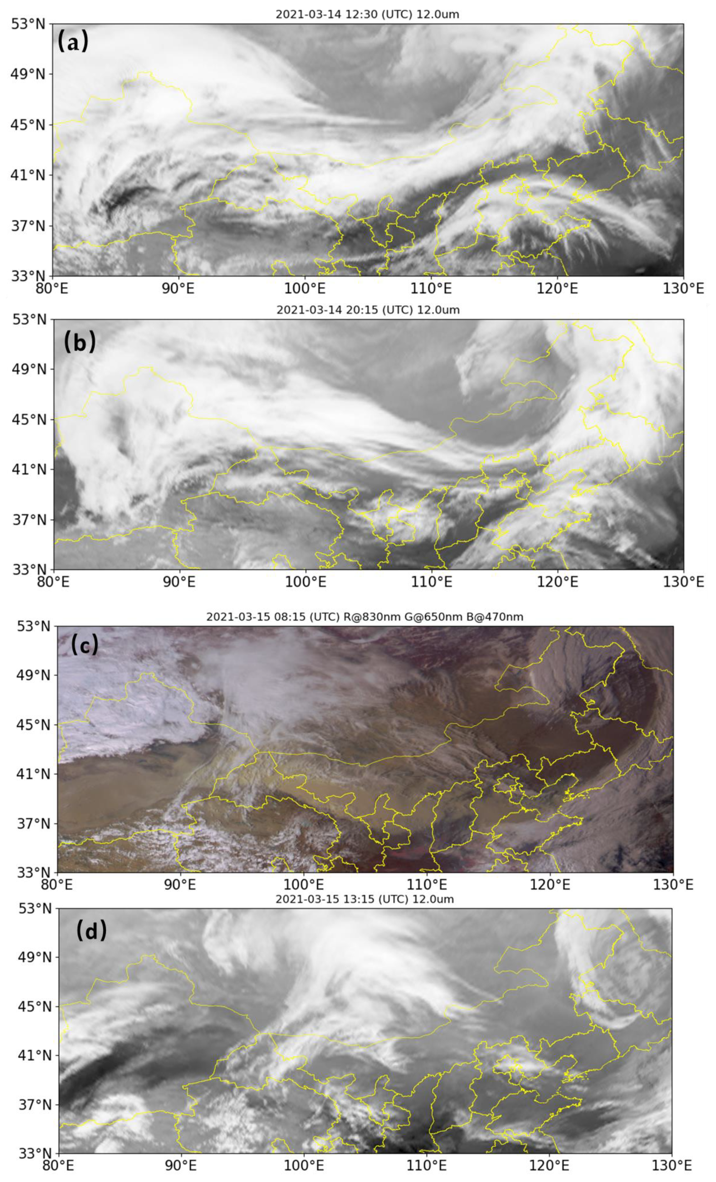
The dynamic evolution of dust storm weather and frontal cloud processes is intricately connected. Cold fronts and warm fronts combine to create frontal cloud systems, which, along with low-pressure systems at the ground level, form frontal cyclones. Due to the low water vapor content in the warm frontal cloud system, precipitation formation is challenging. Consequently, the sand and dust carried by the cold air mass from the north behind the cold front takes advantage of this situation and moves along with the frontal cyclone, resulting in sand and dust weather.
Figure 5 shows cloud imagery captured by the Fengyun satellite during this dust storm event. Panel a, b, and d display images obtained from the 12 μm channel, while panel c presents an RGB composite image using wavelengths of 830 nm, 650 nm, and 470 nm. Analyzing
Figure 5a, at 12:30 (UTC) on 14 March 2021, a band-shaped cold front cloud system stretches from the eastern part of Xinjiang to the northeast part of Inner Mongolia. This cold front cloud system exhibits an eastward and southward trend with notable intensity. By around 20:15 (UTC) on 14 March, as depicted in
Figure 5b, a spiral cloud system forms over northern China, showing a significant increase in intensity compared to noon on 14 March. At this time, the tail of the cloud system is located in Inner Mongolia, accompanied by the emergence of dust rain. On 15 March, as depicted in
Figure 5c, the cold front cloud system continues its movement through the eastern and southern regions of China. Dust storms started to emerge in Inner Mongolia and across most of northern China. In addition,
Figure 5c is a color image, so it records the details of the areas where the dust storms passed through more clearly than the other three figures. As time progresses, the cold front cloud system further develops, as shown in
Figure 5d, and the northern and southeastern coastal regions of China also come under the influence of this dust storm.
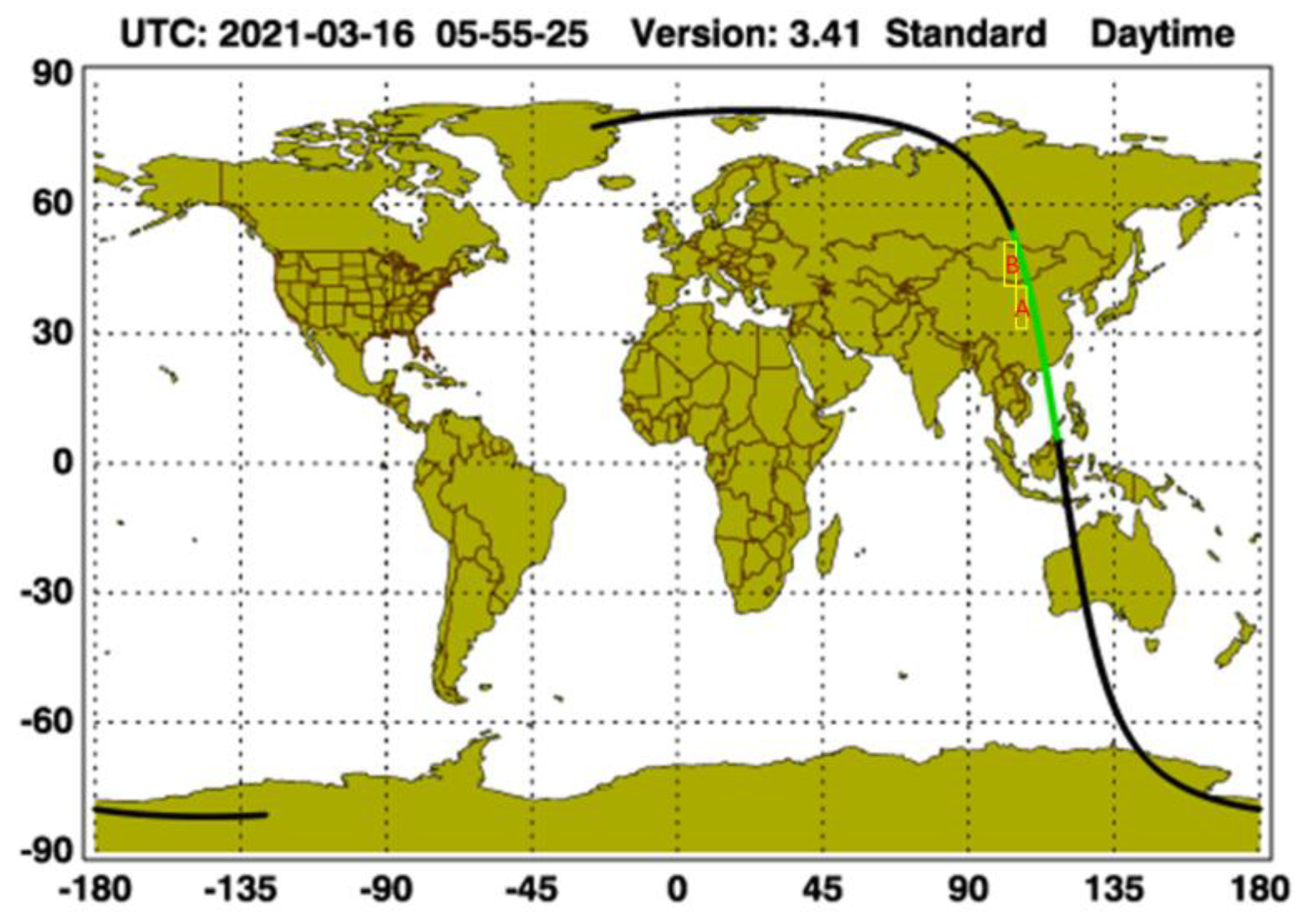
Figure 6 depicts the trajectory of CALIPSO as it transited through the impacted region of the severe dust storm on 16 March 2021 at 5:55 a.m. The trajectory primarily traversed the source areas of this potent dust storm, including Mongolia, Inner Mongolia, Ningxia, Shanxi, and Shaanxi. Area A mainly covers the south-central regions of Ningxia, Shanxi, Shaanxi and Inner Mongolia, while Area B mainly includes northern Inner Mongolia and most of Mongolia. Area A, B in
Figure 6 and A, B in
Figure 7 are the same Area. These provinces were significantly affected by the dust storm. As shown in
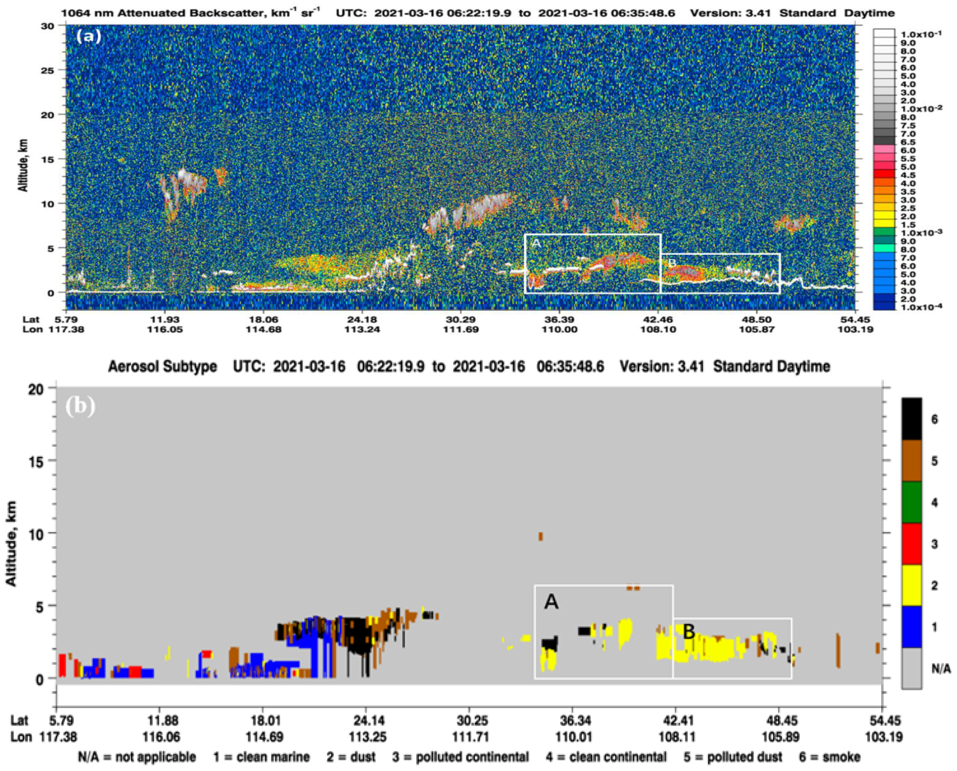
Figure 7, it becomes apparent that CALIOP detected dust aerosols while passing through Inner Mongolia, Ningxia, Shanxi, Shaanxi, and Mongolia. In
Figure 7, Area A predominantly covers the central and southern regions of Ningxia, Shanxi, Shaanxi, and Inner Mongolia, while Area B mainly includes the northern part of Inner Mongolia and most regions of Mongolia. According to the data presented in Area A of
Figure 7a, as the satellite passes over Ningxia, Shanxi, Shaanxi, and the central and southern regions of Inner Mongolia, a continuous aerosol layer is evident below 4 km. The backward scattering coefficient for this aerosol layer exceeds 5 × 10
−3 km
−1sr
−1, indicating a notably high aerosol concentration. Among these regions, Ningxia, Shanxi, and Shaanxi display the highest aerosol concentrations. In Area B of
Figure 7a, where the satellite primarily traverses Mongolia, a layer of aerosols with a heightened concentration is observed near the surface, approximately 1.2 km above ground level. The backward scattering coefficient for this aerosol layer reaches 1 × 10
−2 km
−1sr
−1. Relative to the aerosols in Area A, those in Area B exhibit significantly higher concentrations and a broader range of variation. The combination of
Figure 7a,b reveals that the dust aerosol heights in Ningxia, Shanxi, and Shaanxi range from approximately 0.4 km to 3.2 km, with the dust cloud tops in the central and southern parts of Inner Mongolia ranging from about 2 km to 4 km. In the northern part of Inner Mongolia and Mongolia, dust aerosol heights range from 1 km to 4.2 km, with a relatively uniform distribution. The intensity, prolonged duration, and extensive impact of this severe dust storm weather are evident. The signals detected by CALIPSO during its transit from northern Inner Mongolia to entering Mongolia indicate the presence of a high-altitude dust belt at around 3 km from south to north. It can be preliminarily determined that Mongolia is one of the main source regions for this intense dust storm weather.
4. Conclusions
In this paper, an investigation into the transboundary transport of dust aerosols during a severe dust storm event in China in March 2021 was conducted. The research utilized meteorological observations of PM2.5 and PM10, HYSPLIT model for backward trajectory analysis, ground-based Lidar detection, Fengyun satellite AGRI payload data, and CALIPSO satellite Lidar data. The key findings are summarized as follows.
Firstly, spanning from 14th to 16th March 2021, a notable dust storm event affected large parts of Northern China, resulting in the widespread coverage of haze pollution. During this episode, concentrations of PM2.5 and PM10 were relatively elevated, with a significant prevalence of coarse particles. The air quality in five cities—Wuzhong, Xi’an, Beijing, Jinan, and Handan—experienced significant impacts, with Wuzhong enduring the longest duration of influence. Notably, due to its considerable distance from the dust source, Hefei was relatively less affected during this intense dust storm. Secondly, the ground-based Lidar observation network, encompassing six Chinese cities (Wuzhong, Jinan, Xi’an, Handan, Beijing, and Hefei), provided a comprehensive depiction of the entire process of the dust storm. Throughout the dust storm period, the heights of the dust aerosol particle layers at the six sites were predominantly concentrated within 2 km. Additionally, the depolarization ratio exhibited a gradual decrease as the dust particles moved from entry to transit. Among these stations, the Xi’an site encountered two instances of intense sandstorm weather, and notably, the origins of these two events differed. The recorded entry times for dust at each Lidar station closely align with the entry times provided by authoritative agencies, serving as indirect evidence of the authenticity and precision of the Lidar network observations. Thirdly, CALIPSO satellite observations unveiled a high-altitude dust belt distributed at heights ranging from 3 km to 5 km, extending from the northern part of Inner Mongolia to the central region of Mongolia. Substantial transboundary transport of high-altitude dust aerosols was observed in the northern part of Ningxia, the central and northern parts of Inner Mongolia, and most regions of Mongolia. Backward trajectory analysis using HYSPLIT and cloud image analysis from Fengyun satellite indicated that the dust originated from the Gobi Desert in Mongolia and the deserts in Northwestern China. The primary transport routes were identified as the northern and northwestern directions.
In this context, the ground-based Lidar observation network, equipped with the capability to discern aerosol vertical characteristics, overcame limitations inherent to one-dimensional air quality monitoring from ground stations and two-dimensional observation images from satellites. This breakthrough facilitates a more nuanced understanding of the transboundary transport dynamics of dust storms. Through the integration of sky and ground measurements utilizing satellites, ground monitoring stations, and a Lidar network, the entire process of this severe sandstorm weather event was unveiled. This comprehensive approach not only disclosed the temporal and spatial distribution details of the strong sandstorm but also offered substantial data support for the analysis of the sources and species of dust and aerosols in the region. The insights garnered from this in-depth research and application of the ground-based Lidar observation network and CALIPSO satellite during this severe dust storm lay the groundwork for advancing fine-scale three-dimensional atmospheric detection, enhancing air pollution control measures, and fortifying disaster prediction capabilities on a broader scale.


 ,
, 


