Abstract
In the face of the climate change crisis, the increase in air temperature negatively impacts rice crop productivity due to stress from water scarcity. The objective of this study was to determine the rice crop water stress index (CWSI) and stomatal conductance (Gs) under different irrigation regimes, specifically continuous flood irrigation treatments (CF) and irrigations with alternating wetting and drying (AWD) at water levels of 5 cm, 10 cm, and 20 cm below the soil surface (, and ) in an experimental area of INIA-Vista Florida and in six commercial areas of the Lambayeque region using thermal images captured with thermal sensors. The results indicated that AWD irrigation generated more water stress, with CWSI values between 0.4 and 1.0. Despite this, the yields were similar in CF and In the commercial areas, CWSI values between 0.38 and 0.51 were obtained, with Santa Julia having the highest values. Furthermore, a strong Pearson correlation (R) of 0.91 was established between the CWSI and Gs, representing a reference scale based on Gs values for evaluating water stress levels.
1. Introduction
Rice plays a crucial role in providing sustenance for more than half of the global population and requires a significant amount of water for its growth [1]. Approximately 70% of the world’s water resources are utilized for agricultural purposes, with 34% to 43% of irrigation water being allocated to rice cultivation [2,3]. In the 2022/23 season, worldwide rice production reached a staggering 519.8 million tons [4]. However, the escalating water crisis in rice-producing nations poses a severe threat to food security [1].
To address this pressing issue, innovative agricultural technologies are necessary to optimize irrigation practices and reduce water consumption. This would involve moving away from the conventional method of continuous flooding (CF), which demands a substantial volume of water. Several alternative techniques have been advocated for adoption by farmers, including the alternating wetting and drying (AWD) irrigation method, the aerobic rice system, the system of rice intensification (SRI), saturated soil cultivation (SSC), direct seeding of rice (DSR), drip irrigation, and automated surface gravity irrigation systems [1,5]. The implementation of AWD stands out due to its intermittent and controlled application of floods throughout the rice growing cycle. This approach allows for a reduction in overall water usage while ensuring that the rice crop receives an appropriate amount of water during critical stages of production to prevent negative impacts on yield and grain quality [6,7].
Unmanned aerial vehicles (UAVs) have a wide range of applications in agriculture [8]. They can be utilized for monitoring the growth rate and condition of crops, estimating biomass, and detecting water stress [9,10]. Since 1970, the assessment of crop water status has involved the use of plant canopy temperature. The crop water stress index (CWSI) is the most commonly used indicator of thermal origin, which quantifies crop water status using temperature thresholds, also known as baselines. Various types of sensors are available to estimate canopy temperature, with IRT sensors placed within the canopy and the thermography technique being the most frequently employed [11]. In recent times, there has been an increasing use of infrared thermographic cameras to measure crop temperature () and plant water stress. These cameras allow the capture of thermal images of the plant surface in a fast and efficient manner. In addition, this technology is characterized by being non-invasive, non-contact and non-destructive [10,12,13,14]. This technology enables the monitoring of CWSI variations, providing valuable information on the spatial and temporal distribution of crop water requirements. Consequently, farmers are able to take appropriate measures to ensure and potentially enhance crop yields [15,16].
Stomatal conductance, which plays a crucial role in processes like photosynthesis and transpiration, is primarily influenced by environmental factors such as temperature, soil moisture, solar radiation, and water vapor pressure deficit. These factors determine the variability in stomatal conductance and act as regulators for vegetation equilibrium [17]. Olalekan et al. [18] found a positive correlation between relative leaf water content and stomatal conductance under optimal water conditions. Conversely, Alvarez et al. [19] demonstrated that most plants reduce their stomatal conductance in response to a decrease in soil water content.
In 2022, the production of paddy rice in Peru reached 3 million tons, with the regions of Lambayeque and La Libertad being the highest producers [20]. In the coastal valleys, 82% of the rice area is cultivated using irrigation, while 18% relies on rainfed irrigation [21]. However, the high water consumption associated with flooded irrigation (12,000 to 20,000 ) is leading to a rise in the water table and subsequent soil salinization [22]. This, in turn, is reducing agricultural land and decreasing productivity in the coastal valleys. Additionally, water scarcity is becoming a growing challenge, particularly for rice cultivation, where water deficit is a major form of abiotic stress [23]. Nonetheless, it is important to note that with proper management, there is potential to enhance both crop quality and yield. In Peru, there have not been studies on CWSI, stomatal conductance (Gs), and UAVs, so this study is a pioneer in evaluating various irrigation regimes CF and AWD. In this way, it seeks to address water deficit conditions in Lambayeque.
The objective of this study was to evaluate water stress and Gs in rice crops under different AWD and CF irrigation regimes in experimental and commercial areas of the Lambayeque region. For this purpose, the collection of field data (radiometer and portable weather station) allowed for the estimation of a more robust and accurate CWSI. In addition, a relationship between the CWSI and Gs was established to develop a technological tool to monitor water stress in rice crops in order to improve irrigation management efficiency.
2. Materials and Methods
Figure 1 depicts the research methodology employed in this study, which took place during the rice growing season from December to June.
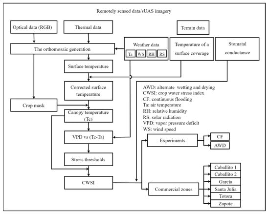
Figure 1.
Flow diagram of the methodology followed in this study.
2.1. Study Area
The research was conducted in the Lambayeque region, situated on the northern coast of Peru. An experimental area was designated for the application of AWD irrigation, while the commercial areas employed the CF technique. The experiment was carried out at the rice plots of the Agricultural Experimental Station (EEA) “Vista Florida”, which is part of the National Institute for Agrarian Innovation (INIA) and is located in the district of Picsi, province of Chiclayo (Figure 2c). Six commercial rice areas were chosen for the study: Caballito 1, Caballito 2, Garcia, Santa Julia, Totora, and Zapote. These areas are all situated in the district and province of Ferreñafe (Figure 2d). Table 1 provides information on the five rice varieties used in the different study areas.
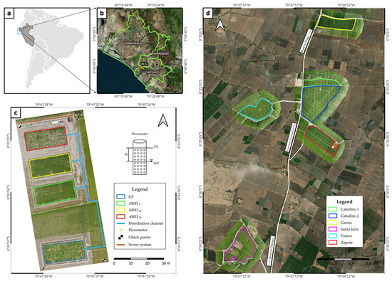
Figure 2.
Study area: (a) geographical location; (b) Lambayeque region; (c) Experimental Agricultural Station (EEA) “Vista Florida” with four plots of each, divided into three subplots of m, with two irrigation regimes of continuous flooding (CF) and alternating wetting and drying (AWD), the latter having water levels at 5 cm, 10 cm, and 20 cm below the soil surface level (, and ); (d) commercial areas: Caballito 1, Caballito 2, García, Santa Julia, Totora, and Zapote, located in the district and province of Ferreñafe.

Table 1.
Characteristics of the study area.
The experimental area at INIA-Vista Florida has a soil with a sandy loam texture, consisting of 26% sand, 39% clay, and 35% silt. The soil has a bulk density (da) of 1.41 g and a real density (dr) of 2.67 g (Table 2). The porosity of the soil is 47.2%. The field capacity (FC) is 29.76%, while the permanent wilting point (PWP) is 16.27%. The soil has an electrical conductivity (EC) of 0.42 dS and a hydrogen potential (pH) of 7.64. The cation exchange capacity (CEC) is 220 meq . The soil contains 1.22% organic matter (OM), 0.11% total N, 4.02% , 12 ppm P, and 376 ppm K. These soil characteristics were analyzed at the Soil, Plant, Water, and Fertilizer Analysis Laboratory of the Faculty of Agronomy—UNALM.

Table 2.
Soil physical characteristics.
2.2. Irrigation Management
At the INIA-Vista Florida experimental station, irrigation water is sourced from a canal that receives water from the Tinajones reservoir, which is under the management of the Capote irrigation commission. Throughout the different growth stages of the plants (vegetative, reproductive, and maturation), a total of sixteen, three, and five irrigation cycles were conducted, respectively (Figure S1). The quantity of water used was monitored by utilizing piezometers positioned at depths ranging from 5 to 20 cm [24]. Within the experimental area, the initial treatment was continuous flooding (CF), involving the use of a permanent or traditional flood irrigation method, while the treatments aimed at water conservation utilized irrigations with alternating wetting and drying (AWD) at water levels of 5 cm, 10 cm, and 20 cm below the soil surface (, and ). This study was designed as an observational experiment, with four plots measuring m each, further divided into three m subplots.
In the commercial areas, the irrigation system used was CF, which was facilitated by canals managed by the Ferreñafe irrigation commission. These canals were connected to the main hydraulic system of Tinajones.
The chemical characteristics of the irrigation water are the following: pH 7.34, EC 0.31 dS , cations (1.91; 0.43; 0.59; 0.10) meq , and anions ( 1.00; 1.89; 0.29) meq . The irrigation water is classified as C2-S1, indicating low sodium content and salinity. The sodium absorption ratio (SAR) is 0.55.
In the experimental area, the INIA 515—Capoteña variety was planted on 2 January 2023, using the Almacigo technique. Thirty days post sowing (DPS), two seedlings were transplanted per stroke, with a spacing of 0.25 cm × 0.25 cm (Table 3). The fertilization N-P-K dose was 250-106-60 in the form of urea, diammonium phosphate, and potassium sulfate, respectively. During transplantation, 100% P and K and 30% N were applied. The remaining nitrogen fertilizer was distributed equally at the early tillering, panicle initiation, early flowering, and peak flowering stages [25]. The crop’s phenology was assessed using degree heating days (GDD), a useful index for tracking crop growth [26].

Table 3.
Description of flight dates and days post sowing (DPS) in the experimental area.
In the commercial areas, the phenological cycle of the crop began with the transplantation of the seedlings, which occurred between twenty-eight and thirty days after germination. This took place from February 12 to 28 (Table 4). The reproductive development phase started when the first signs of flowers appeared, at 89 DPS (Figure S1). Harvesting took place in May 2023, between days 145 and 150 DPS. Fertilizer rates differed for the Zapote crop (265-72-50) and the other areas (263-92-75). Fertilizer application was divided as the following: before transplantation, 5% N, 85% P, and 100% K were applied; eighteen days after transplantation, 42% N and 15% P were administered; and the remaining nitrogen fertilizer was distributed equally during the tillering stage and at the cotton point. Figure S1 provides more details on the flights conducted in both the experimental and commercial areas, according to crop phenology.

Table 4.
Description of the flight dates and the corresponding days post sowing (DPS) of the commercial areas.
During the growth of the crops, we conducted insecticide applications to control the presence of Chironomus sp. And Hydrellia wirthii in the vegetative stage [3]. As the crops reached the milky grain stage, we applied fungicides to prevent diseases caused by the fungus Villosiclava virens.
2.3. Field Measurements
2.3.1. Thermal Imaging and Processing
High-resolution thermal images were gathered using a Zenmuse H20T multifunctional digital thermal imager (precision range of 2 °C) from 11 February to 2 June 2023. This camera can capture both thermal and optical images in RGB, as well as radiometric TIF formats. Its temperature measurement range spans from 8 to 14 , with a thermal resolution of 640 × 512 pixels. The camera is equipped with a built-in uncooled Vox microbolometer sensor, 40.6° DFOV lens, focal length of 13.5 mm (equivalent to 58 mm), an aperture scale of f , and a focus of 5 m at . It also features a laser rangefinder with an accuracy of ±(0.2 m + D × 0.15%), with D denoting the distance to a vertical surface. The H20T thermal camera was mounted on a DJI gimbal on the Matrice 300 RTK UAV. The camera and the UAV both operate at a temperature range of −20 °C to 50 °C. The UAV Matrice 300 RTK offers a GPS displacement precision of 0.1 m vertically and 0.3 m horizontally, as well as RTK positioning accuracy and a maximum tilt angle of 30 °C.
The indirect calibration of the thermal images obtained by the H20T camera was performed by comparing them with the data measured with a radiometer in nine coverages. To rescale the temperature values in the thermal images, an Apogee MI-210 radiometer (MI-210; Apogee Instruments, Inc., Logan, UT, USA) was used. This radiometer was used on nine known coverslips, including aluminum, dry leaves, green leaves, expanded polystyrene, yellow cloth, black cloth, red cloth, green cloth, and bare soil. These covers were placed on a 1 × 1 m PVC square. Thermal images were captured at a height of 45 m in the experimental area and at 100 m in the commercial areas. Flights in the experimental area took place between 09:00 and 15:00 h, while in the commercial areas they were carried out from 10:30 to 17:00 h. All flights were scheduled on clear days to minimize the presence of shadows.
The average of the coefficients of determination () were obtained in comparison with the radiometer data and the thermal images, with the objective of identifying the possible combinations of the 8, 7, 6, 5, 4, 3, 2, and 1 coverage. This procedure was carried out for INIA-Vista Florida (blue boxplot) and the commercial areas (green boxplot) (Figure S2). It was observed that the use of multiple coverages, in this case 9, contributed to establishing a temperature gradient that improved the robustness and accuracy of crop temperature in rice fields.
However, the use of four coverages generated a minimum percentage difference of 3% to 4% in the average with respect to nine coverages. This would allow a reduction in data collection time. This is in agreement with Machaca et al. [27], who used four coverages (bare soil, leaf litter, grass, and thawed water) with an of 0.97, and Torres-Rua [28], who used three coverages (bare soil, short green canopy, and tall canopy) with an between 0.58 and 0.95.
For each flight day, an adjustment equation was derived (Figure 3). For the images collected at INIA with meteorological conditions (Figure 4), a general equation was established , with a Pearson’s coefficient® of 0.959 and a root mean square error (RMSE) of 6.309 °C. Similarly, for the nearby commercial areas (Caballito 1, Caballito 2, Totora, and Zapote) (Figure 2d), a second general equation was established , with a Pearson’s coefficient® of 0.960 and a root mean square error (RMSE) of 5.544 °C. This general equation was also applied to the commercial area of Garcia, which experienced similar climatic conditions (Figure 5).
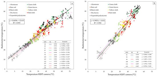
Figure 3.
Relationship between the H20T chamber and radiometer temperatures: (a) experimental area of the Agricultural Experimental Station (EEA) “Vista Florida” and (b) commercial areas.
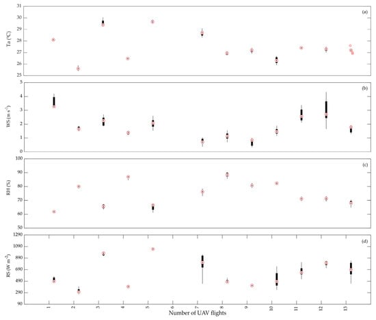
Figure 4.
The meteorological conditions in the experimental area in 2023, as indicated by the UAV flight number, including (a) air temperature (); (b) wind speed (WS, m ); (c) relative humidity (RH, %); and (d) solar radiation (SR, W ).
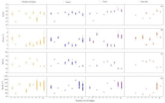
Figure 5.
The meteorological conditions in commercial areas in 2023, as indicated by the UAV flight number, including (a) air temperature (); (b) wind speed (WS, m ); (c) relative humidity (RH, %); and (d) solar radiation (SR, W ).
In the commercial area of Santa Julia, the final area in the UAV data collection, small fluctuations in wind speed (WS) and solar radiation (SR) were observed, influenced by the order in which the data were collected. It is noted that the air temperature () and relative humidity (RH) in Santa Julia are similar to the conditions recorded in the other commercial areas. In this regard, Dong et al. [29] analyzed the impact of various meteorological variables (, RH, WS, and SR) from 1961 to 2020, revealing that the values of and RH used to calculate the vapor pressure deficit (VPD) are the variables with the greatest impact in determining the crop water stress index (CWSI).
The temperature orthomosaics were generated using Pix4Dmapper Pro 4.4.12 software (Pix4D S.A., Prilly, Switzerland). Mainly, three standard procedures were performed consisting of the following: alignment of the photographs, generation of a point cloud, and creation of orthomosaics with digital surface models (DSMs). Then, the resolution was homogenized by the resample method at 3.5 and 1.5 cm for the experimental and commercial areas, respectively. In addition, a supervised classification (maximum likelihood) of the images was performed using QGIS 3.32 software to obtain the vegetation mask for each orthomosaic generated.
2.3.2. Stomatal Conductance
A direct measurement sensor, Decagon Model SC-1 porometer (METER Group, Pullman, WA, USA), was used to measure stomatal conductance (Gs) and crop temperature (). This device allows the measurement of Gs in a range from 0 mmol to 1200 mmol , with an accuracy of 10%. In addition, it is capable of operating in a temperature range of 5 °C to 40 °C, with a maximum relative humidity of 100%. The measurements were performed minutes prior to the execution of the UAV flight plan between 9:00 a.m. and 12:00 p.m. The sensor head was placed on the leaf surface of three plants in each subplot with three replicates. From the data collected in the field, a specific value scale relating rice stomatal conductance to the crop water stress index was developed. This approach is important as there are reference scales for other crops, such as beans [30], to monitor whether the crop is within the range of optimal water conditions.
2.3.3. Meteorological Conditions
The collection of meteorological data is fundamental to calculating the crop water stress index (CWSI), highlighting the importance of air temperature and relative humidity for this calculation [11]. Therefore, meteorological data for the UAV flight dates were obtained from the ATMOS 41 portable automatic weather station in the experimental area (Table S1) and in the commercial areas (Table S2), which have SDI-12 digital communication capabilities to transmit data from environmental sensors. This weather station, installed at an altitude of 2 m, was connected to a model ZL6 data logger. Data collected included air temperature (, °C), relative humidity, (RH, %), solar radiation, (SR, W ), and wind speed (WS, m ). The station was located at the center of each study area, at six different points during the course of the day.
2.3.4. Determination of the Crop Water Stress Index (CWSI)
For the temperature data collection, we employed the H20T thermal camera integrated into the UAV, following the methodology used in Section 2.3.1. A mask was subsequently created to isolate leaf-only temperatures, excluding water bodies.
The atmospheric vapor pressure deficit (VPD, kPa) was calculated from air temperature and relative humidity using a portable weather station [31], Equation (1):
where is the air temperature (°C) and RH is the relative humidity (%).
Reference baselines were calculated according to [32]. The lower limit (LL) values were calculated from the baseline of the unstressed crop, which was derived from the linear relationship of the temperature difference and the vapor pressure deficit (VPD), according to Equation (2), and the upper limit (UL) values in conditions of minimal or non-existent transpiration were determined with different maximum temperatures or remained constant at different levels of VPD [33]. The coefficients a and b were determined by the linear regression of the scatterplot between vs. VPD Equation (2).
The CWSI according to [34] is defined as the following:
where is the difference between crop temperature and air temperature.
Various studies on the CWSI in rice cultivation, considering diverse environmental conditions, irrigation methods, soil types, thermal sensors, and threshold temperatures, are presented in Table 5. The highest CWSI values were observed in regions with humid subtropical climates, specifically in Kunshan, Jiangsu, Heilongjiang (China), and New Delhi (India).

Table 5.
Rice crop water stress index (CWSI) values from various studies.
3. Results
3.1. The Weather Conditions in the Field
Figure 4 illustrates the meteorological conditions during the study period in the experimental area, while Figure 5 provides information on the commercial areas. The ambient temperature ranged from 25 °C to 31 °C. The wind speed varied between 1 m and 5 m , with fluctuations primarily caused by wind gusts in the study area. Relative humidity exhibited high variability, ranging from 55% to 95%. Solar radiation showed a range of 100 W to 1200 W , with the lowest values observed in Santa Julia due to the specific time interval of the UAV flight, which occurred between 14 and 17 h.
3.2. Baseline Condition with the Presence of Water Stress (UL) and without the Presence of Water Stress (LL)
The highest temperature was recorded between 12:00 and 14:00, yielding the maximum CWSI value. The timing of field measurements significantly influences results [37,40]. Scatter plots established the relationship between the VPD and to determine limits and , which were obtained through measurements between 9:00 and 10:30 and between 11:00 and 13:00, respectively (Figure 6).
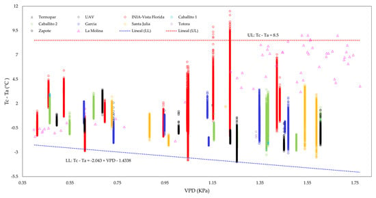
Figure 6.
The relationship between the difference in temperature between the air and plant canopy () and the vapor pressure deficit (VPD) of rice was studied during continuous flooding (CF) and alternating wetting and drying (AWD) conditions in the experimental and commercial area. The data were collected from 15 February to 2 June 2023.
The data used for this analysis were gathered from both experimental and commercial areas in the Lambayeque region. To ensure the accuracy of the measurements, additional experiments were conducted in La Molina, where thermocouple sensors were placed in pots. The UP was determined to be 8.5 °C, while the LL is represented by the equation . By analyzing the images captured during flights 9 and 10 in the experimental and Zapote commercial areas, respectively, the LL representing optimal conditions without stress was identified. On the other hand, the UL, which represents maximum stress conditions, was obtained from images collected in treatment during Flight 06-INIA.
3.3. CWSI
The variations in average crop temperatures during different phenological stages at various flight dates are depicted in Figure 7a,b. These data reveal significant fluctuations in environmental conditions throughout the crop cycle. In Figure 7a, it can be observed that crop temperatures increased during flights 5 and 6. This was attributed to the occurrence of Cyclone Yaku [45] and the insufficient water supply from irrigation canals. However, a decrease in temperature values was observed starting from flight 7, which occurred towards the end of the vegetative phase and the beginning of the reproductive phase. This decline can be attributed to the occurrence of rainfall, reaching up to 26.8 mm da in the days preceding the monitoring, as well as the application of irrigation in the experimental plots. Conversely, Figure 7b illustrates an increase in crop temperatures from flight 8 onwards. This rise in temperatures is connected to the ripening phase of the crop, which necessitates the drying process of the grains before harvesting.
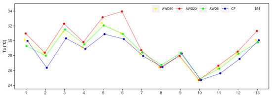
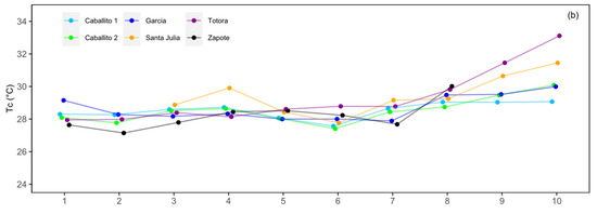
Figure 7.
The changes in average crop temperature based on the dates of UAV flights: (a) alternate wetting and drying (AWD) and continuous flooding (CF) and (b) temperature changes in the commercial areas that utilized CF irrigation.
The boxplots in Figure 8a–d display the CWSI values for the experimental area, ranging from 0 to 1. Figure 8a illustrates the lowest CWSI values, which resulted from continuous flood irrigation CF. Conversely, Figure 8d depicts the highest CWSI values, attributed to treatment , which had a reduced water sheet.
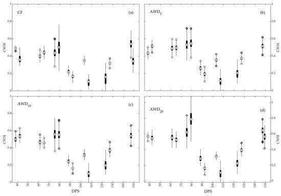
Figure 8.
The temporal changes in the crop water stress index (CWI) as a function of different irrigation regimes. In panel (a), the irrigation regime is continuous flooding (CF). Panels (b–d) show the alternate wetting and drying (AWD) irrigation regime with various water levels relative to the soil surface.
The maximum average CWSI values for the commercial areas are displayed in Figure 9a–f. The Caballito 1 and Caballito 2 areas had maximum values of 0.41 and 0.38, respectively, at 113 DPS. Zapote had a maximum value of 0.47 at 127 DPS. In the Garcia area, the maximum value was 0.40 at 84 DPS. The Santa Julia area recorded a maximum value of 0.51 at 93 DPS. The range of maximum CWSI averages varied from 0.38 to 0.51, with a DPS range of 84 to 113. Notably, the highest value was observed in Santa Julia with the INIA 510—Mallares variety, while the lowest value was recorded in Caballito 2 with the INIA 515—Capoteña variety.
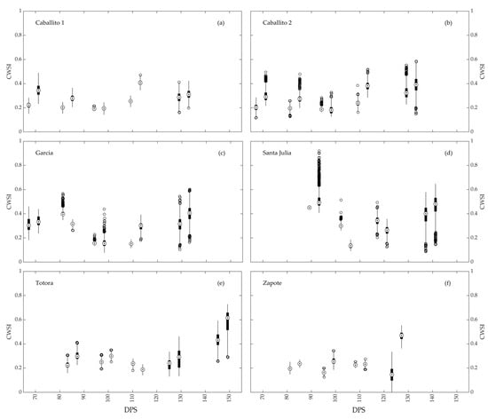
Figure 9.
The temporal variation in the crop water stress index (CWSI) in commercial areas with the continuous flooding irrigation regime (CF) was observed in six locations: (a) Caballito 1; (b) Caballito 2; (c) García; (d) Santa Julia; (e) Totora; and (f) Zapote.
3.4. The Relationship between Stomatal Conductance and the Crop Water Stress Index (CWSI)
Figure 10a depict the correlation between crop temperature () and stomatal conductance (Gs), both measured with a porometer, obtaining a coefficient of determination () of 0.92. In Figure 10b, the correlation between the CWSI and Gs is presented, resulting in an value of 0.83. Both graphs demonstrate a pronounced Pearson correlation, with coefficients of 0.96 and 0.91, respectively.
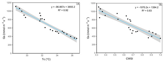
Figure 10.
Two relationships involving stomatal conductance in crops. (a) The relationship between crop temperature (°C) and stomatal conductance in mmol (b) The relationship between the crop water stress index (CWSI) and stomatal conductance in mmol .
Based on the evaluation of the data collected, a reference scale is proposed to determine water stress levels from stomatal conductance (Gs) values (Figure 11). This scale was elaborated upon by taking into account previous research [30]. The equation presented in Figure 10b was used to calculate the reference scale. This proposal is based on the relationship between the crop water stress index (CWSI) and Gs values. In this context, higher Gs values, obtained in the experimental area and in the commercial areas with continuous flood irrigation (CF), indicate luxury transpiration. In contrast, the lowest values, obtained in the treatment, indicate moderate to extreme stress.

Figure 11.
Reference scale to determine water stress levels based on stomatal conductance (Gs) values.
The variation in Gs in the INIA-Vista Florida experimental area, indicating crop transpiration levels, is depicted in Figure 12. A total of 14 flights were conducted, with the first six flights occurring during the vegetative phase on days 38, 42, 61, 65, 75, and 79 DPS. Flights 7–10 correspond to the reproductive phase on days 88, 92, 103, and 107 DPS, while flights 11–14 were conducted during the maturation phase on days 123, 127, 147, and 149 DPS. Figure 12a–d show that transpiration levels remained within the optimal range due to adequate rainfall and irrigation prior to each monitoring. However, Figure 12e,f clearly indicate that the crop experienced water stress during the transition from the vegetative to the reproductive phase, primarily due to insufficient water availability. Flights 13 and 14 (Figure 12m,n) captured the crop in the ripening phase, and it faced a period of drought before harvest, leading to increased temperatures.
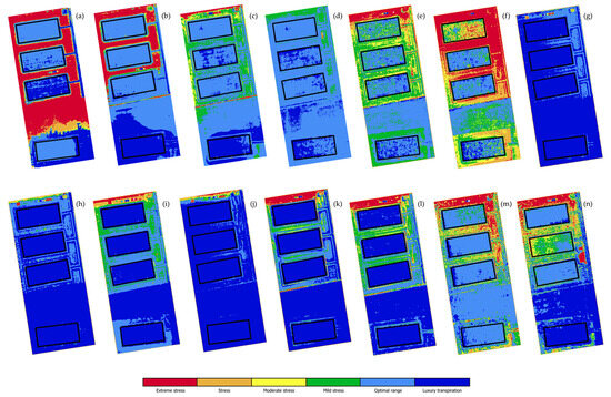
Figure 12.
The water stress levels in the experimental area using the Gs mmol reference scale: (a) 38 DPS, (b) 42 DPS, (c) 61 DPS, (d) 65 DPS, (e) 75 DPS, (f) 79 DPS, (g) 88 DPS, (h) 92 DPS, (i) 103 DPS, (j) 107 DPS, (k) 123 DPS, (l) 127 DPS, (m) 147 DPS, and (n) 149 DPS.
The graph presented in Figure 13 depicts the changes in Gs in the commercial area of Santa Julia. In the initial four flights (89, 93, 102, and 106 DPS), most of the plots within this area maintained an optimal range. However, two plots were identified as experiencing water stress due to soil salinity issues, resulting in a lack of crop transplantation. In the final four flights (117, 121, 137, and 141 DPS), which correspond to the crop maturation stage, a noticeable shift in Gs was observed. The levels reached moderate and mild stress, particularly during the waxy grain development phase of the crop.
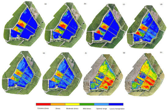
Figure 13.
The levels of water stress in the Santa Julia commercial area are represented according to the Gs mmol reference scale. The water stress levels are the following: (a) 89 DPS; (b) 93 DPS; (c) 102 DPS; (d) 106 DPS; (e) 117 DPS; (f) 121 DPS; (g) 137 DPS; and (h) 141 DPS.
The additional information shows that there is observable diversity in stomatal conductance within the commercial areas of Caballito 1, Caballito 2, Garcia, Totora, and Zapote, as depicted in Figures S3–S6.
3.5. The Yields of Crops in Both the Experimental and Commercial Areas
According to Figure 14, it can be observed that significantly higher rice yields were obtained in the experimental area compared to the commercial areas. The treatments that recorded the highest and lowest yields for the experimental area are CF and , respectively.

Figure 14.
The yield levels of both the experimental and commercial areas.
4. Discussions
Variations in thermal data obtained from infrared thermal cameras can occur due to factors such as wind speed (WS), solar radiation (SR), and atmospheric interferences, resulting in temperature differences in several degrees Celsius [46]. To ensure the accurate determination of the crop water stress index (CWSI), a portable weather station was utilized to obtain reliable meteorological data. This is important because, as highlighted by Gonzalez-Dugo et al. [11], precise measurement of environmental conditions is crucial for calculating the CWSI, especially since meteorological data in many studies are often obtained from remote stations. Furthermore, the temperature values obtained from thermal images were adjusted using information from an Apogee MI-210 radiometer (Figure S5), demonstrating a favorable correlation between the temperatures captured by the H20T thermal camera and the radiometer, as recommended by Torres-Rua [28]. Moreover, Ribeiro-Gomes et al. [47] discuss the impact of UAV flight altitude on thermal images, as the measured temperature is negatively correlated with altitude.
A humid temperate climate is characterized by a high level of relative humidity (RH), resulting in low vapor pressure deficit (VPD) conditions. It is crucial to establish a reference baseline for water stress (LL) based on the specific environmental conditions [40]. When determining the LL empirically, there is an observed increase in the uncertainty of the crop water stress index (CWSI), considering the sensitivity of rice varieties to VPD when selecting the LL. In an arid desert climate, the humidity influences the LL, leading to higher uncertainty in the CWSI [23]. In our study, the LL was calculated using morning data and days with a lower RH were taken into account. It was found that the highest daily water stress occurred at midday in the water deficit treatments , and , which aligns with a previous study conducted by Ref. [39].
The irrigation method known as alternate wetting and drying (AWD) has a direct impact on the temperature of crops, and it was expected that different levels of water stress would elicit a response. As a result, the highest crop temperature () values were recorded with irrigation, while the lowest value was observed with traditional irrigation. Furthermore, the values of the crop water stress index (CWSI) exhibited variations ranging from 0 to 1. During the tillering phase, CWSI values remained high (0.2 and 1), indicating water stress. Conversely, during the reproductive phase, CWSI values were lower. However, during the maturation phase, particularly at the time of a pasty and waxy grain, CWSI values increased to 0.8, indicating a water deficit. It is worth noting that the behavior of the CWSI was different in the commercial areas of Caballito 1, Caballito 2, and García. When comparing the CWSI values obtained with those documented by the authors in Table 5, it is evident that areas with AWD irrigation regimes and similar soil texture exhibited a comparable range of CWSI values.
The findings indicate that the diurnal pattern of the CWSI is influenced by both the evaporative demand of the air and the significant increase in solar radiation (SR) and air temperature during midday. These conditions resulted in a higher rate of crop transpiration compared to the rate of soil moisture uptake by roots [39]. Consequently, a water deficit occurred to some extent, leading to high CWSI values in both the experimental and commercial areas. It is worth noting that the lowest CWSI values were observed during the cotton point and initial flowering phase in both the experimental and commercial areas, which was attributed to the impact of rainfall from cyclone Yaku [45] and abnormal precipitation before [48] the UAV flight.
In the experimental area, various irrigation regimes were implemented. These different regimes had a significant impact on stomatal conductance (Gs) and crop yield. The treatment with the lowest water stress displayed a higher Gs and yield, as evidenced by Figure 8, Figure 12, and Figure 14, when compared to the other treatments. In contrast, the treatment with the highest water stress, (Figure 12f), exhibited a lower Gs. These findings contradict a previous study on high-yielding rice crops [18,49], where a decrease in Gs and yield was observed. It is worth noting that this decrease occurred at different levels of volumetric soil water content (VWC) for each variety, indicating varying responsiveness to stress conditions. These variations in crop responses highlight the complexity of adaptation mechanisms to water stress, suggesting the existence of diverse coping strategies.
As a result of this research, the integration of UAV thermal imagery and CWSI maps in agriculture offers several practical applications that can improve irrigation and crop management practices in rice fields. By utilizing these technologies, agriculturalists can apply specific irrigation methods that are customized to the unique requirements of each section of their fields. This optimizes water consumption and enhances the productivity of their crops.
Early detection of water stress becomes a tool for timely decision making. By monitoring CWSI variations in crops, growers can detect signs of water stress at an early stage. Also, understanding the relationship between the CWSI and stomatal conductance gives growers a quick understanding of plant physiological processes related to transpiration. This allows for quick interventions, such as adjustments in irrigation schedules or the application of water conservation techniques to reduce potential yield losses.
5. Conclusions
According to these research findings, the implementation of the AWD irrigation technique results in a noteworthy elevation in the rice crop water stress index (CWSI) in contrast to the continuous flooding (CF) method (Figure 8). Despite this rise in CWSI in the experimental area utilizing AWD irrigation, a greater yield was observed compared to the commercial areas employing CF irrigation (Figure 14). These results imply that AWD irrigation may present a more sustainable and efficient alternative for water conservation purposes.
These results also indicate a significant correlation between the crop temperature and stomatal conductance Gs, as well as between the CWSI and Gs (Figure 10). This suggests that as water stress increases, stomatal conductance decreases. These findings, combined with the use of UAVs to capture high-quality images, can serve as a technological tool for better monitoring and managing water stress in rice crops. By utilizing the relationship between the CWSI and Gs, the developed tool has the potential to greatly enhance irrigation management efficiency, enabling more precise irrigation decisions and optimizing water usage in rice crops.
In future work, the frequency of UAV flights should be increased and their application extended to a larger number of rice fields to obtain a better characterization of the heterogeneity of these fields. In addition, it would be beneficial to integrate satellite data so that farmers can access information on their crops in real time. On the other hand, an economic evaluation is needed for the adoption of these technologies in order to achieve cost-effectiveness.
Supplementary Materials
The following supporting information can be downloaded at: https://www.mdpi.com/article/10.3390/rs16050796/s1, Figure S1: (a) Flights carried out in the experimental and commercial areas; (b) Phenology according to days post sowing (DPS); Figure S2: Comparison of between INIA-Vista Florida and Commercial areas according to combinations by number of coverages used to collect radiometer data. The was obtained from the comparison between radiometer data and thermal images; Figure S3: The levels of water stress in the Caballito 1 and Caballito 2 commercials areas are represented according to the Gs mmol reference scale. The water stress levels are as follows: (a) 67 DPS; (b) 71 DPS; (c) 81 DPS; (d) 85 DPS; (e) 94 DPS; (f) 98 DPS; (g) 109 DPS; (h) 113 DPS; (i) 129 DPS; (j) 133 DPS; Figure S4: The levels of water stress in the García commercial area are represented according to the Gs mmol reference scale. The water stress levels are as follows: (a) 67 DPS; (b) 71 DPS; (c) 81 DPS; (d) 85 DPS; (e) 94 DPS; (f) 98 DPS; (g) 109 DPS; (h) 113 DPS; (i) 129 DPS; (j) 133 DPS; Figure S5: The levels of water stress in the Totora commercial area are represented according to the Gs mmol reference scale. The water stress levels are as follows: (a) 83 DPS; (b) 87 DPS; (c) 97 DPS; (d) 101 DPS; (e) 110 DPS; (f) 114 DPS; (g) 125 DPS; (h) 129 DPS; (i) 145 DPS; (j) 149 DPS; Figure S6: The levels of water stress in the Zapote commercial area are represented according to the Gs mmol reference scale. The water stress levels are as follows: (a) 81 DPS; (b) 85 DPS; (c) 95 DPS; (d) 99 DPS; (e) 108 DPS; (f) 112 DPS; (g) 123 DPS; (h) 127 DPS; Table S1: Meteorological data from the portable station in INIA-Vista Florida experimental area; Table S2: Meteorological data from portable station in commercial areas.
Author Contributions
Conceptualization, L.R.-F. and A.T.-R.; methodology, M.G.-Q., J.H.-M. and L.R.-F.; validation, D.T.-Q. and A.T.-R.; investigation, L.R.-F., E.H.-A., L.F.d.P. and A.T.-R.; resources, D.T.-Q., L.R.-F. and A.T.-R.; data curation, M.G.-Q., J.H.-M. and D.T.-Q.; writing—original draft preparation, M.G.-Q. and J.H.-M.; writing—review and editing, L.R.-F., E.H.-A. and L.F.d.P.; supervision, L.R.-F., E.H.-A., L.F.d.P. and A.T.-R. All authors have read and agreed to the published version of the manuscript.
Funding
This research was funded by National Scientific Research and Advanced Studies Program (PROCIENCIA) of PROCIENCIA-Peru, under the project “Implementation of technological tools in the development of a precision system with remote sensors to optimize the use of water and reduce the emission of greenhouse gases in rice fields for the benefit of farmers in the Lambayeque region” (Contract No. PE501078113-2022).
Data Availability Statement
The data presented in this study are available upon request from the corresponding author.
Acknowledgments
This paper was written as a result of a collaboration that was initiated by Contract No. PE501078113-2022.
Conflicts of Interest
The authors declare no conflicts of interest.
References
- Mallareddy, M.; Thirumalaikumar, R.; Balasubramanian, P.; Naseeruddin, R.; Nithya, N.; Mariadoss, A.; Eazhilkrishna, N.; Choudhary, A.K.; Deiveegan, M.; Subramanian, E.; et al. Maximizing Water Use Efficiency in Rice Farming: A Comprehensive Review of Innovative Irrigation Management Technologies. Water 2023, 15, 1802. [Google Scholar] [CrossRef]
- Shafi, S.; Shafi, I.; Zaffar, A.; Zargar, S.M.; Shikari, A.B.; Ranjan, A.; Prasad, P.V.V.; Sofi, P.A. The Resilience of Rice under Water Stress Will Be Driven by Better Roots: Evidence from Root Phenotyping, Physiological, and Yield Experiments. Plant Stress 2023, 10, 100211. [Google Scholar] [CrossRef]
- Surendran, U.; Raja, P.; Jayakumar, M.; Subramoniam, S.R. Use of Ef-ficient Water Saving Techniques for Production of Rice in India un-der Climate Change Scenario: A Critical Review. J. Clean. Prod. 2021, 309, 127272. [Google Scholar] [CrossRef]
- Food and Agriculture Organization of the United Nations. Food Outlook—Biannual Report on Global Food Markets—June 2023; Food and Agriculture Organization of the United Nations: Rome, Italy, 2023; ISBN 978-92-5-137230-2. [Google Scholar]
- Champness, M.; Ballester-Lurbe, C.; Filev-Maia, R.; Hornbuckle, J. Charter Six—Smart Sensing and Automated Irrigation for Sustainable Rice Systems: A State of the Art Review. In Advances in Agronomy; Academic Press: Cambridge, MA, USA, 2023; Volume 177, pp. 259–285. ISBN 9780443192586. [Google Scholar]
- Price, A.H.; Norton, G.J.; Salt, D.E.; Ebenhoeh, O.; Meharg, A.A.; Meharg, C.; Islam, M.R.; Sarma, R.N.; Dasgupta, T.; Ismail, A.M.; et al. Alternate Wetting and Drying Irrigation for Rice in Bangladesh: Is It Sustainable and Has Plant Breeding Something to Offer? Food Energy Secur. 2013, 2, 120–129. [Google Scholar] [CrossRef]
- Arouna, A.; Dzomeku, I.K.; Shaibu, A.G.; Nurudeen, A.R. Water Management for Sustainable Irrigation in Rice (Oryza sativa L.) Production: A Review. Agronomy 2023, 13, 1522. [Google Scholar] [CrossRef]
- Huang, H.; Yang, A.; Tang, Y.; Zhuang, J.; Hou, C.; Tan, Z.; Dananjayan, S.; He, Y.; Guo, Q.; Luo, S. Deep Color Calibration for UAV Imagery in Crop Monitoring Using Semantic Style Transfer with Local to Global Attention. Int. J. Appl. Earth Obs. Geoinf. 2021, 104, 102590. [Google Scholar] [CrossRef]
- Pino, V.E. Drones A Tool for Efficient Agriculture: A High-Tech Future. Idesia 2019, 37, 75–84. [Google Scholar] [CrossRef]
- Wen, T.; Li, J.H.; Wang, Q.; Gao, Y.Y.; Hao, G.F.; Song, B.A. Thermal Imaging: The Digital Eye Facilitates High-Throughput Phenotyping Traits of Plant Growth and Stress Responses. Sci. Total Environ. 2023, 899, 165626. [Google Scholar] [CrossRef] [PubMed]
- Gonzalez-Dugo, V.; Zarco-Tejada, P.J. Assessing the Impact of Measurement Errors in the Calculation of CWSI for Charac-terizing the Water Status of Several Crop Species. Irrig. Sci. 2022, 1–13. [Google Scholar] [CrossRef]
- Mwinuka, P.R.; Mbilinyi, B.P.; Mbungu, W.B.; Mourice, S.K.; Mahoo, H.F.; Schmitter, P. The Feasibility of Hand-Held Thermal and UAV-Based Multispectral Imaging for Canopy Water Status Assessment and Yield Prediction of Irrigated African Eggplant (Solanum aethopicum L). Agric. Water Manag. 2021, 245, 106584. [Google Scholar] [CrossRef]
- Wu, Y.; Jiang, J.; Zhang, X.; Zhang, J.; Cao, Q.; Tian, Y.; Zhu, Y.; Cao, W.; Liu, X. Combining Machine Learning Algorithm and Multi-Temporal Temperature Indices to Estimate the Water Status of Rice. Agric. Water Manag. 2023, 289, 108521. [Google Scholar] [CrossRef]
- Luan, Y.; Xu, J.; Lv, Y.; Liu, X.; Wang, H.; Liu, S. Improving the Performance in Crop Water Deficit Diagnosis with Canopy Temperature Spatial Distribution Information Measured by Thermal Imaging. Agric. Water Manag. 2021, 246, 106699. [Google Scholar] [CrossRef]
- Visitacion, G.J.; Saludes, R.B.; Luyun, R.A.; Mochica Pinca, Y.M.; Ferdie Eusebio, M.V. Statistical Analysis of Crop Water Stress in Rainfed Rice (Oryza sativa L.) Using Spectral and Non-Spectral Indices. Philipp. J. Sci. 2022, 151, 587–603. [Google Scholar] [CrossRef]
- Katimbo, A.; Rudnick, D.R.; DeJonge, K.C.; Lo, T.H.; Qiao, X.; Franz, T.E.; Nakabuye, H.N.; Duan, J. Crop Water Stress Index Computation Approaches and Their Sensitivity to Soil Water Dynamics. Agric. Water Manag. 2022, 266, 107575. [Google Scholar] [CrossRef]
- Qi, Y.; Zhang, Q.; Hu, S.; Wang, R.; Wang, H.; Zhang, K.; Zhao, H.; Zhao, F.; Chen, F.; Yang, Y.; et al. Applicability of Stomatal Conductance Models Comparison for Persistent Water Stress Processes of Spring Maize in Water Resources Limited Environmental Zone. Agric. Water Manag. 2023, 277, 108090. [Google Scholar] [CrossRef]
- Olalekan Suleiman, S.; Gajere Habila, D.; Mamadou, F.; Mutiu Abolanle, B.; Nurudeen Olatunbosun, A. Grain Yield and Leaf Gas Exchange in Upland NERICA Rice under Repeated Cycles of Water Deficit at Reproductive Growth Stage. Agric. Water Manag. 2022, 264, 107507. [Google Scholar] [CrossRef]
- Álvarez, S.; Navarro, A.; Bañón, S.; Sánchez-Blanco, M.J. Regulated Deficit Irrigation in Potted Dianthus Plants: Effects of Severe and Moderate Water Stress on Growth and Physiological Responses. Sci. Hortic. 2009, 122, 579–585. [Google Scholar] [CrossRef]
- Ministerio de Desarrollo Agrario y Riego. Productive and Competitive Profile of the Main Crops in the Sector. Available online: https://siea.midagri.gob.pe/portal/siea_bi/index.html (accessed on 3 December 2023).
- Caldas, J.; Lizárraga, A. Technical Guide: Management of Rice Crop Under the Intermittent Dry Irrigation System in the Regions of Tumbes, Piura, Lambayeque and La Libertad; National Institute of Agrarian Innovation: La Molina, Perú, 2020; ISBN 9789972440496. [Google Scholar]
- Heros Aguilar, E.C.; Lozano Isla, F.; Casas Díaz, A.V. Technologies for Rice Production: Recommendations for Peru Based on Scientific Research. South Sustain. 2023, 4, 1–5. [Google Scholar] [CrossRef]
- Villar Barraza, H.D.; Ramos Fernández, L.; Alminagorta Cabezas, O. Evaluation of Water Stress of Rice Crop (IR 71706) through the Use of Calibrated Canopy Area Thermography in Lima, Peru. Idesia 2021, 39, 59–70. [Google Scholar] [CrossRef]
- Yang, J.; Zhou, Q.; Zhang, J. Moderate Wetting and Drying Increases Rice Yield and Reduces Water Use, Grain Arsenic Level, and Methane Emission. Crop J. 2016, 5, 151–158. [Google Scholar] [CrossRef]
- Heros Aguilar, E.; Gómez Pando, L.; Sosa, G. Use of Selection Indices in the Identification of Drought Tolerant Rice Genotypes (Oryza sativa L.). Agric. Prod. Sustain. Dev. 2014, 2, 11–31. [Google Scholar] [CrossRef]
- Porras Jorge, R.; Ramos Fernández, L.; Ojeda Bustamante, W.; Ontiveros Capurata, R.E. Performance Assessment of the AquaCrop Model to Estimate Rice Yields under Alternate Wetting and Drying Irrigation in the Coast of Peru. Sci. Agropecu. 2020, 11, 309–321. [Google Scholar] [CrossRef]
- Machaca-Pillaca, R.; Pino-Vargas, E.; Ramos-Fernández, L.; Quille-Mamani, J.; Torres-Rua, A. Estimation of Evapotranspiration for Irrigation Purposes in Real Time of an Olive Grove from Drone Images in Arid Areas, Case of La Yarada, Tacna, Peru. Idesia 2022, 40, 55–65. [Google Scholar] [CrossRef]
- Torres-Rua, A. Vicarious Calibration of SUAS Microbolometer Temperature Imagery for Estimation of Radiometric Land Surface Temperature. Sensors 2017, 17, 1499. [Google Scholar] [CrossRef]
- Dong, J.; Wu, L.; Zeng, W.; Xiao, X.; He, J. Analysis of Spatial-Temporal Trends and Causes of Vapor Pressure Deficit in China from 1961 to 2020. Atmos. Res. 2024, 299, 107199. [Google Scholar] [CrossRef]
- Vega Ponce, E.C.; Mejía Marcacuzco, J.A. Performance of Phaseolus Vulgaris under Partial Root-Zone Drying Cultivated in a Hydrogravitropic System Response. Sci. Agropecu. 2017, 8, 137–147. [Google Scholar] [CrossRef]
- Allen, R.G.; Pereira, L.S.; Raes, D.; Smith, M. Crop Evapotranspiration-Guidelines for Computing Crop Water Requirements; FAO Irrigation and Drainage Paper 56; FAO: Rome, Italy, 1998; pp. 35–37, D05109. [Google Scholar]
- Idso, S.B. Non-Water-Stressed Baselines: A Key to Measuring and Interpreting Plant Water Stress. Agric. Meteorol. 1982, 27, 59–70. [Google Scholar] [CrossRef]
- López López, R.; Arteaga Ramírez, R.; Alberto Vázquez Peña, M.; López Cruz, I.; Sánchez Cohen, I. Water Stress Index as an Indicator of Irrigation Timing in Agricultural Crops. Agric. Técnica en México 2009, 35, 92–106. [Google Scholar]
- Idso, S.B.; Jackson, R.D.; Pinter, P.J.; Reginato, R.J.; Hatfield, J.L. Normalizing the Stress-Degree-Day Parameter for Environmental Variability. Agric. Meteorol. 1981, 24, 45–55. [Google Scholar] [CrossRef]
- Jackson, R.D.; Kustas, W.P.; Choudhury, B.J. A reexamination of the crop water stress index. Irrig. Sci. 1988, 9, 309–317. [Google Scholar] [CrossRef]
- Gao, M.C.; Zhang, W.Z.; Han, Y.D.; Yao, C.; Wang, Y.T.; Ding, G.H. A Theoretical Model Research of Rice Water Stress Index Based on Automated Infrared Thermal Imaging. Adv. Mat. Res. 2013, 712–715, 433–438. [Google Scholar] [CrossRef]
- Durán Gómez, R.M.; Ramos Fernández, L.; Altamirano Gutiérrez, L.; Arapa Quispe, J. Thermal Imaging and Thermocouple Sensors to Estimate Water Stress Index of Rice Crop Under Drip Irrigation. Idesia 2021, 49, 109–118. [Google Scholar] [CrossRef]
- Konate, A.; Zongo, A.; Sangaré, J.; Dardou, A.; Audebert, A. High-Throughput Phenotyping for Drought Tolerance in Rice. World J. Adv. Res. Rev. 2021, 12, 379–391. [Google Scholar] [CrossRef]
- Xu, J.; Lv, Y.; Liu, X.; Dalson, T.; Yang, S.; Wu, J. Diagnosing Crop Water Stress of Rice Using Infra-Red Thermal Imager under Water Deficit Condition. Int. J. Agric. Biol. 2016, 18, 565–572. [Google Scholar] [CrossRef]
- Godson Amamoo, S.; Kato, T.; Katsura, K. Empirical Setting of the Water Stressed Baseline Increases the Uncertainty of the Crop Water Stress Index in a Humid Temperate Climate in Different Water Regimes. Water 2022, 14, 1833. [Google Scholar] [CrossRef]
- Elsherbiny, O.; Zhou, L.; Feng, L.; Qiu, Z. Integration of Visible and Thermal Imagery with an Artificial Neural Network Approach for Robust Forecasting of Canopy Water Content in Rice. Remote Sens. 2021, 13, 1785. [Google Scholar] [CrossRef]
- Krishna, G.; Sahoo, R.N.; Singh, P.; Bajpai, V.; Patra, H.; Kumar, S.; Dandapani, R.; Gupta, V.K.; Viswanathan, C.; Ahmad, T.; et al. Comparison of Various Modelling Approaches for Water Deficit Stress Monitoring in Rice Crop through Hyperspectral Remote Sensing. Agric. Water Manag. 2019, 213, 231–244. [Google Scholar] [CrossRef]
- Fitriyah, A.; Fatikhunnada, A.; Okura, F.; Nugroho, B.D.A.; Kato, T. Analysis of the Drought Mitigated Mecha-nism in Terraced Paddy Fields Using CWSI and TVDI Indices and Hydrological Monitoring. Sustainability 2019, 11, 6897. [Google Scholar] [CrossRef]
- Sakaguchi, A.; Schelfhout, C.; Fujimaki, H.; Siddique, K.H.M. A Method for Detecting Irrigation Needs Using a UAV. [CrossRef]
- National Service of Meteorology and Hydrology of Peru—SENAMHI Effect of Cyclone Yaku and its Path. 2023. Available online: https://sinia.minam.gob.pe/documentos/efecto-ciclon-yaku-recorrido (accessed on 2 December 2023).
- Wan, Q.; Brede, B.; Smigaj, M.; Kooistra, L. Factors Influencing Temperature Measurements from Miniaturized Thermal Infrared (Tir) Cameras: A Laboratory-Based Approach. Sensors 2021, 21, 8466. [Google Scholar] [CrossRef]
- Ribeiro Gomes, K.; Hernández López, D.; Ortega, J.F.; Ballesteros, R.; Poblete, T.; Moreno, M.A. Uncooled Thermal Camera Calibration and Optimization of the Photogrammetry Process for UAV Applications in Agriculture. Sensors 2017, 17, 2173. [Google Scholar] [CrossRef] [PubMed]
- National Meteorological and Hydrological Service of Peru—SENAMHI National Climate Bulletin: Climate Monitoring and Forecasting. 2023. Available online: https://hdl.handle.net/20.500.12542/2776 (accessed on 25 November 2023).
- Barnaby, J.Y.; Rohila, J.S.; Henry, C.G.; Sicher, R.C.; Reddy, V.R.; McClung, A.M. Physiological and Metabolic Responses of Rice to Reduced Soil Moisture: Relationship of Water Stress Tolerance and Grain Production. Int. J. Mol. Sci. 2019, 20, 1846. [Google Scholar] [CrossRef] [PubMed]
Disclaimer/Publisher’s Note: The statements, opinions and data contained in all publications are solely those of the individual author(s) and contributor(s) and not of MDPI and/or the editor(s). MDPI and/or the editor(s) disclaim responsibility for any injury to people or property resulting from any ideas, methods, instructions or products referred to in the content. |
© 2024 by the authors. Licensee MDPI, Basel, Switzerland. This article is an open access article distributed under the terms and conditions of the Creative Commons Attribution (CC BY) license (https://creativecommons.org/licenses/by/4.0/).