Improved Simulated Annealing Algorithm on the Design of Satellite Orbits for Common-View Laser Time Transfer
Abstract
1. Introduction
2. System Model for Laser Time Transfer in Common-View
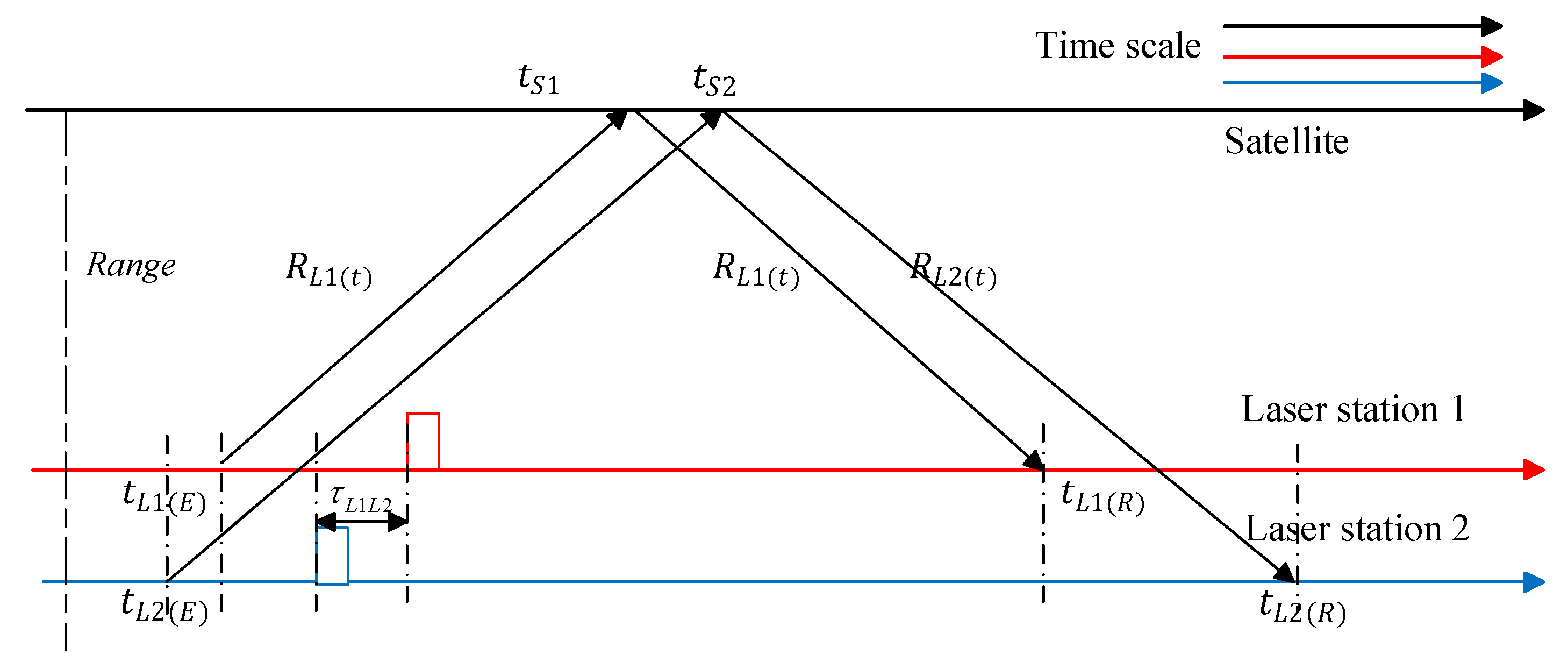
2.1. Ground-to-Ground Laser Time Transfer in Common-View
2.2. Models for Optimized Satellite Orbits Design in Multi-Station Common View
3. Algorithm for Multi-Station Satellite Orbit Optimization in Common-View
3.1. A Description of the Problem
- The initial precise instant in time as defined by the UTC Time system;
- The ground station coordinates, including the separation for each station;
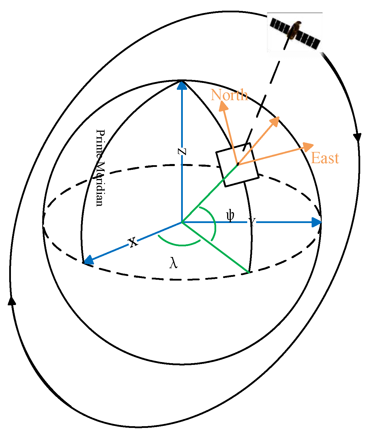
- The Keplerian orbit of the satellite is determined by six parameters: , , , , , and . These parameters define the satellite’s current location coordinates at any given time. For the sake of simplicity, this paper only discusses the case of circular orbits, the = 0, = 0, and = were selected. The mean anomaly of the circular orbits is equal to the eccentric anomaly. This type of orbit is also the choice of most satellites for scientific experiments.
3.2. The Implementation of Optimal Satellite Orbit Algorithm in Common View
3.2.1. Decision Variables
3.2.2. Constraints
- Provide the exact moment in time: A four-dimensional space vector is required for the satellite’s instantaneous Earth coordinate system coordinates, which includes the precise UTC time used to calculate the satellite coordinates at that specific point in time. Therefore, the instant time is denoted as .
- Boundaries of and : The shape of a satellite’s orbit is determined by its orbital inclination and the right ascension of the ascending node. Therefore, it is necessary to establish reasonable ranges for the upper and lower boundaries of these parameters. Specifically, the orbital inclination and right ascension of the ascending node should be framed within the ranges and .
- Angular velocity constraint: If we assume that the satellite orbit is a closed circular one, then it operates at an angular rate that satisfies Kepler’s third law, which is .
- Ground laser station coordinates: Different observable time periods correspond to distinct ground laser station coordinates, that is .
- Observation elevation angle constraint: The design of the satellite orbit must ensure that during observation at different stations, the elevation angle of observation is larger than the station’s lowest observation elevation angle, or .
- Common-view time constraint: The satellite’s orbit must be designed in order to fulfill the requirement that, upon passing through several orbital planes, the satellite is visible to ground stations for the greatest possible amount of time. This is indicated by the following equation: .
3.3. Simulation Annealing Algorithm and Optimization
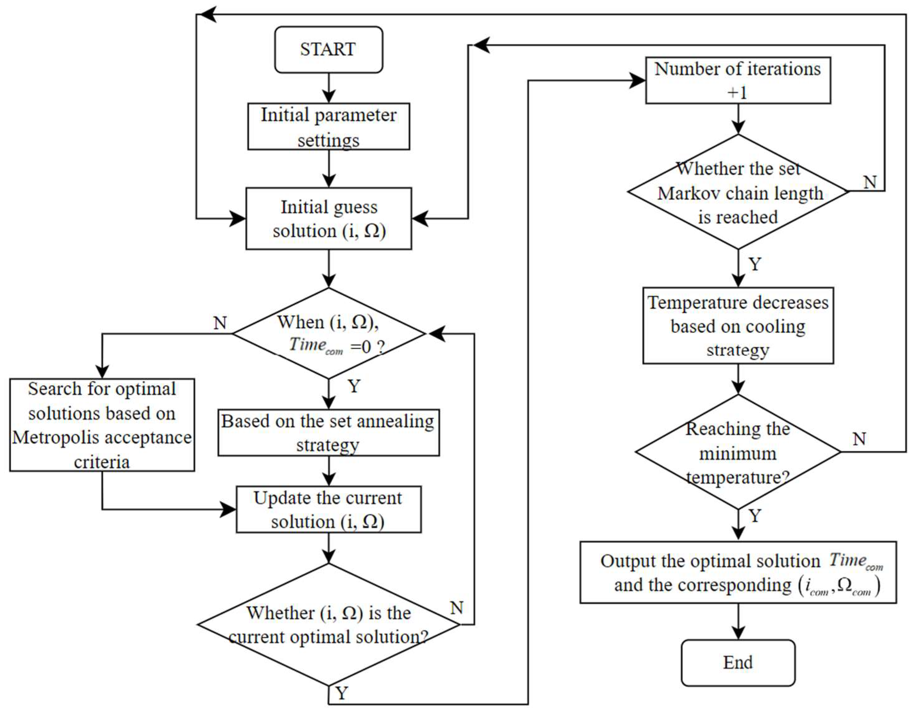
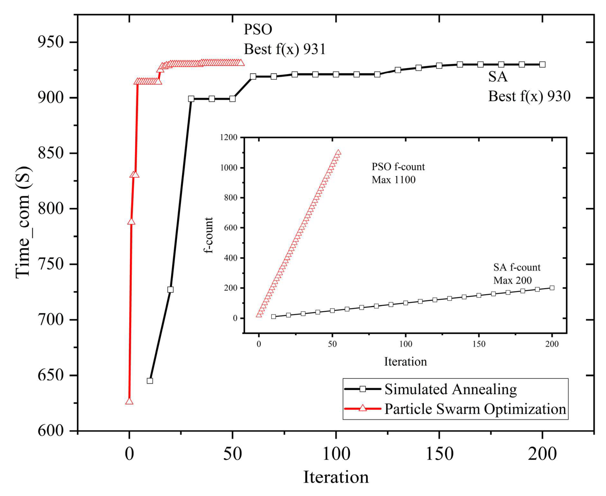
- Initial parameter settings: The initial guesses are selected randomly, while the upper and lower parameter boundaries are set at and , correspondingly. The length of the Markov chain is set at 200.
- Cooling strategy: We adopt the linear annealing schedule, given by , where is the initial temperature and is the cooling coefficient [30]. To expand the search space, the initial temperature is set at 500. Following this, linear cooling is performed to set the cooling coefficient to 0.8. The Metropolis criterion is a criterion for accepting new solutions [30]. This will aid in quick convergence, reducing randomness, and avoiding local optimum solutions as confirmed by the Metropolis acceptance criterion.
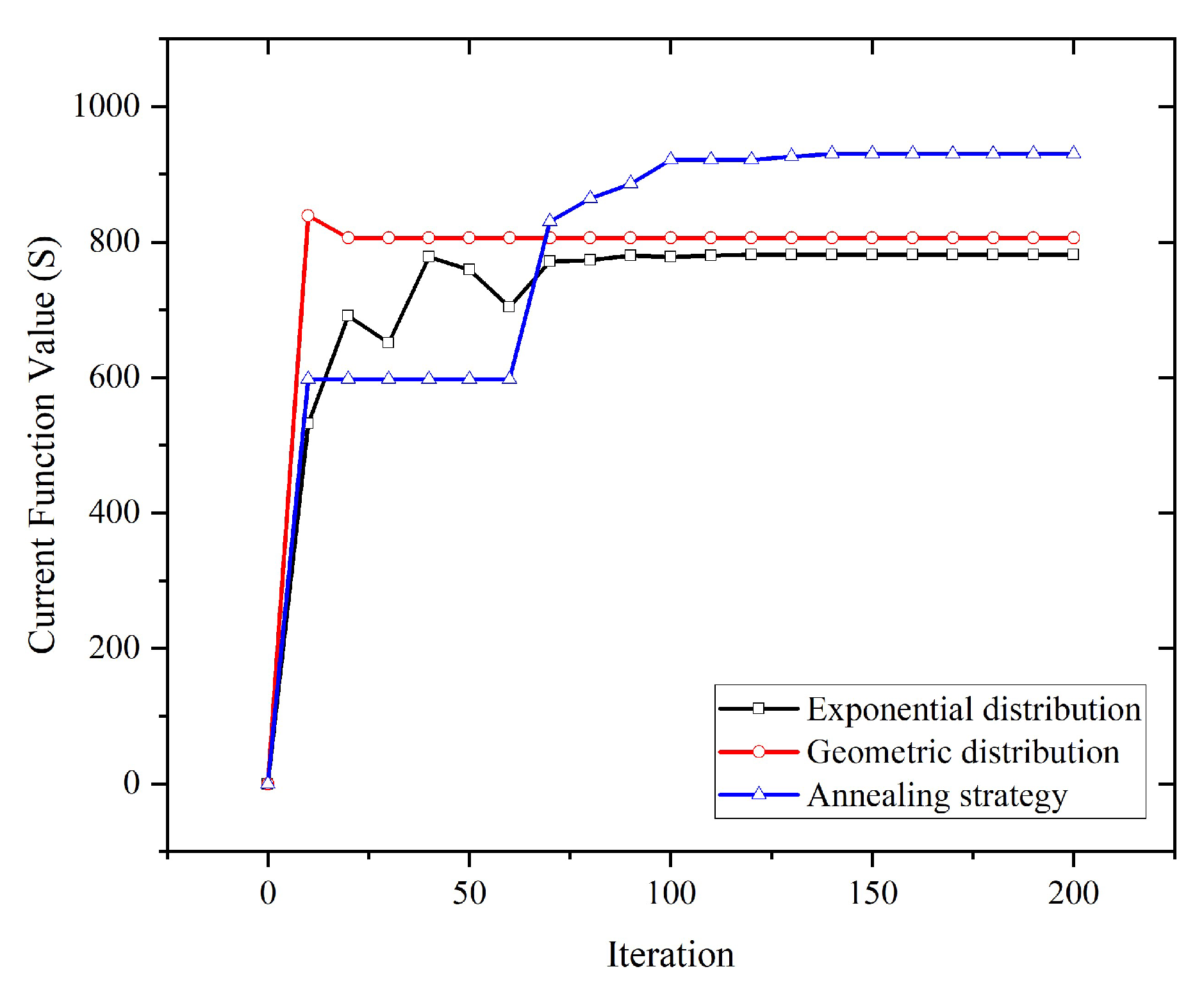
- Perturbation strategy: With the introduction of control strategies and by focusing perturbation strategies, various perturbation techniques are established, aligning with distinct Markov chain period durations. A Markov chain is a type of stochastic process in which the future state of the system is determined solely by its current state, without any influence from its past evolution [29]. For Markov chain length intervals from 0 to 60, the algorithm employs a geometric distribution perturbation strategy, using an early increase in perturbation amplitude to escape local optima. For Markov chain length intervals from 60 to 120, a uniform distribution is used, producing values ranging from −5 to 5 to expedite convergence based on the current best solution. For Markov chain length intervals from 120 to 180, the Gaussian distribution perturbation approach was applied to improve search efficiency. Inside the Markov chain length interval of 180 to 200, a uniform distribution is used to achieve a value concentration within the range of −0.1 to 0.1. This enhances the search for optimal solutions.
4. Analysis
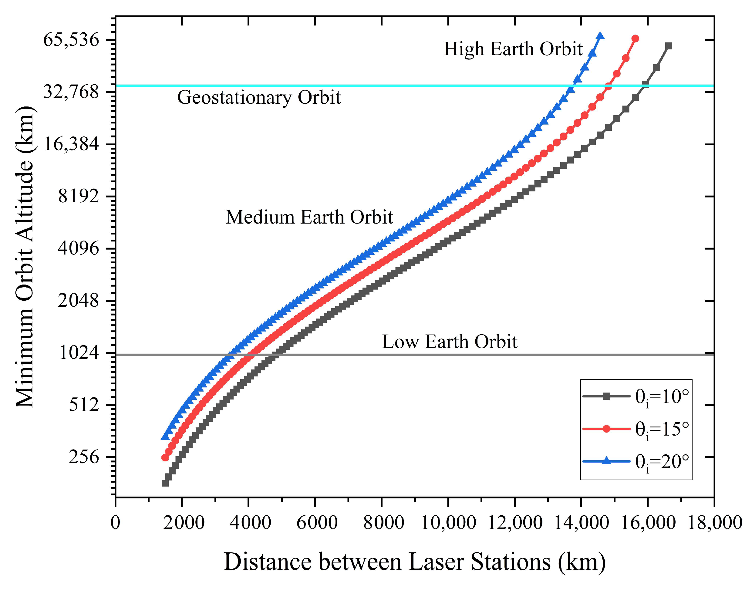
4.1. Minimum Orbit Altitude
4.2. Simulation Experiments for the Optimal Satellite Orbit in the Common-View Mode between Two Stations
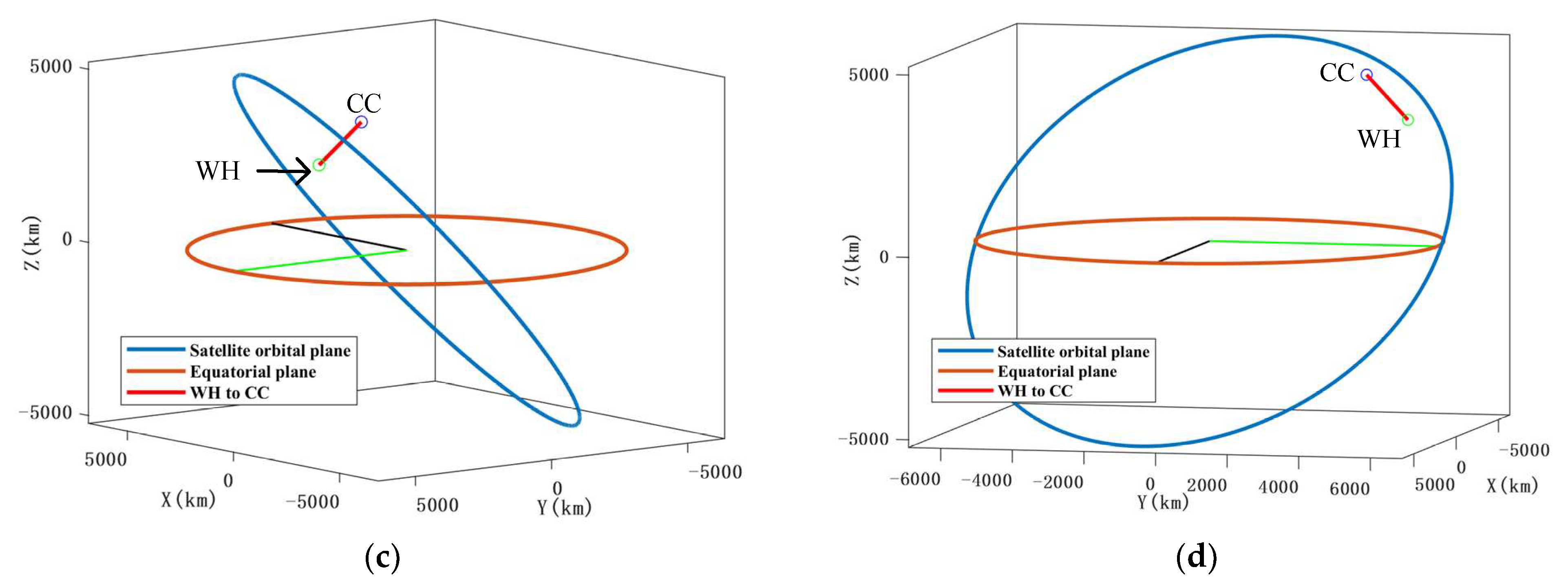
- The optimal orbit inclination in circular orbits involving SLR stations and satellites is determined through geometric analysis. This analysis operates under the assumption that the longest common-view duration between two SLR stations takes place when the plane of the circular orbit is perpendicular to the connecting line (L1 to L2), which is regarded as the angular momentum of the circular orbit.
- Compute the common-view time of different ascending node right ascension at a specified orbital altitude and inclination angle.
- Investigate the orbital altitudes impact on the duration of common view.
- Determine the optimal orbit configuration to facilitate common view between the two stations.
4.3. The Improved Simulated Annealing Algorithm Optimizes Satellite Orbits in a Multi-Station Common-View Model
5. Conclusions
Author Contributions
Funding
Data Availability Statement
Acknowledgments
Conflicts of Interest
References
- Exertier, P.; Samain, E.; Martin, N.; Courde, C.; Laas-Bourez, M. Time Transfer by Laser Link: Data analysis and validation to the ps level. Adv. Space Res. 2014, 54, 2371–2385. [Google Scholar] [CrossRef]
- Park, J.U.; Lim, H.-C.; Sung, K.-P.; Choi, M. Link Budget Analysis with Laser Energy for Time Transfer Using the Ajisai Satellite. Remote Sens. 2021, 13, 3739. [Google Scholar] [CrossRef]
- Samain, E.; Rovera, G.D.; Torre, J.-M.; Courde, C.; Belli, A.; Exertier, P.; Uhrich, P.; Guillemot, P.; Sherwood, R.; Dong, X.; et al. Time Transfer by Laser Link (T2L2) in Noncommon View Between Europe and China. IEEE Trans. Ultrason. Ferroelectr. Freq. Control 2018, 65, 927–933. [Google Scholar] [CrossRef]
- Kirchner, D. Two-Way Time Transfer via Communication Satellites. Proc. IEEE 1991, 79, 983–990. [Google Scholar] [CrossRef]
- Meng, W.; Zhang, H.; Huang, P.; Wang, J.; Zhang, Z.; Liao, Y.; Ye, Y.; Hu, W.; Wang, Y.; Chen, W. Design and experiment of onboard laser time transfer in Chinese Beidou navigation satellites. Adv. Space Res. 2013, 51, 951–958. [Google Scholar] [CrossRef]
- Fridelance, P.; Veillet, C. Operation and data analysis in the LASSO experiment. Metrologia 1995, 32, 27–33. [Google Scholar] [CrossRef]
- Samain, É.; Weick, J.; Vrancken, P.; Para, F.; Albanese, D.; Paris, J.; Torre, J.-M.; Zhao, C.; Guillemot, P.; Petitbon, I. Time transfer by laser link—The t2l2 experiment on jason-2 and further experiments. Int. J. Mod. Phys. D 2008, 17, 1043–1054. [Google Scholar] [CrossRef]
- Fridelance, P.; Samain, E.; Veillet, C. T2L2—Time Transfer by Laser Link: A New Optical Time Transfer Generation. Exp. Astron. 1997, 7, 191–207. [Google Scholar] [CrossRef]
- Vrancken, P. Characterization of T2L2 (Time Transfer by Laser Link) on the Jason 2 Ocean Altimetry Satellite and Micrometric Laser Ranging. Ph.D. Thesis, Université de Nice, Sophia-Antipolis, Nice, France, 2008. [Google Scholar]
- Samain, E.; Exertier, P.; Courde, C.; Fridelance, P.; Guillemot, P. Time transfer by laser link: A complete analysis of the uncertainty budget. Metrologia 2015, 52, 423–432. [Google Scholar] [CrossRef]
- Ritz, T.; Coogan, D.; Conklin, J.W.; Coffaro, J.T.; Serra, P.; Nydam, S.; Hanson, J.; Nguyen, A.N. Laser time-transfer facility and preliminary results from the CHOMPTT CubeSat mission. Adv. Space Res. 2023, 71, 4498–4520. [Google Scholar] [CrossRef]
- Samain, E.; Vrancken, P.; Weick, J.; Guillemot, P. T2L2 Flight Model Metrological Performances. In Proceedings of the IEEE International Frequency Control Symposium Joint with the 21st European Frequency and Time Forum, Geneva, Switzerland, 29 May–1 June 2007. [Google Scholar]
- Delva, P.; Courde, C.; Samain, E.; Kostic, U. Augmenting the Time and Frequency Transfer Capabilities of Galileo. In Proceedings of the 2020 European Navigation Conference (ENC), Dresden, Germany, 23–24 November 2020; pp. 1–8. [Google Scholar] [CrossRef]
- Michalak, G.; Glaser, S.; Neumayer, K.H.; König, R. Precise orbit and Earth parameter determination supported by LEO satellites, inter-satellite links and synchronized clocks of a future GNSS. Adv. Space Res. 2021, 68, 4753–4782. [Google Scholar] [CrossRef]
- Chen, J.; Xu, L.; Li, X.; Liu, Y.; Li, D.; Zhu, F.; Meng, L. Method of common-view time transfer using communication satellites. Sci. Sin. Technol. 2019, 49, 543–551. [Google Scholar] [CrossRef]
- De Grossi, F.; Marzioli, P.; Cho, M.; Santoni, F.; Circi, C. Trajectory optimization for the horyu-vi international lunar mission. Astrodynamics 2021, 5, 263–278. [Google Scholar] [CrossRef]
- Huang, A.-Y.; Yan, B.; Li, Z.-Y.; Shu, P.; Luo, Y.-Z. Orbit design and mission planning for global observation of Jupiter. Astrodynamics 2020, 5, 39–48. [Google Scholar] [CrossRef]
- Chai, R.; Savvaris, A.; Tsourdos, A.; Chai, S.; Xia, Y. A review of optimization techniques in spacecraft flight trajectory design. Prog. Aerosp. Sci. 2019, 109, 100543. [Google Scholar] [CrossRef]
- Betts, J.T.; Huffman, W.P. Mesh refinement in direct transcription methods for optimal control. Optim. Control Appl. Methods 1998, 19, 1–21. [Google Scholar] [CrossRef]
- Shirazi, A.; Ceberio, J.; Lozano, J.A. Spacecraft trajectory optimization: A review of models, objectives, approaches and solutions. Prog. Aerosp. Sci. 2018, 102, 76–98. [Google Scholar] [CrossRef]
- Kirkpatrick, S.; Gelatt, C.D.; Vecchi, M.P. Optimization by Simulated Annealing. Science 1983, 220, 671–680. [Google Scholar] [CrossRef] [PubMed]
- Ezugwu, A.E.; Shukla, A.K.; Nath, R.; Akinyelu, A.A.; Agushaka, J.O.; Chiroma, H.; Muhuri, P.K. Metaheuristics: A Comprehensive Overview and Classification along with Bibliometric Analysis. Artif. Intell. Rev. 2021, 54, 4237–4316. [Google Scholar] [CrossRef]
- Degnan, J.J. Asynchronous laser transponders for precise interplanetary ranging and time transfer. J. Geodyn. 2002, 34, 551–594. [Google Scholar] [CrossRef][Green Version]
- Zhou, J.; Chen, J.; Hu, X. The Principle and Application of Beidou Satellite Navigation System; Science Press: Beijing, China, 2020; pp. 64–68. [Google Scholar]
- Li, Z.; Wei, E.; Wang, Z.; Peng, B. Space Geodesy; Wuhan University Press: Wuhan, China, 2010; pp. 85–101. [Google Scholar]
- González-Arribas, D.; Soler, M.; Sanjurjo-Rivo, M. Robust aircraft trajectory planning under wind uncertainty using optimal control. J. Guid. Control Dyn. 2018, 41, 673–688. [Google Scholar] [CrossRef]
- Guo, T.; Li, J.; Baoyin, H.; Jiang, F. Pseudospectral methods for trajectory optimization with interior point constraints: Verification and applications. IEEE Trans. Aerosp. Electron. Syst. 2013, 49, 2005–2017. [Google Scholar] [CrossRef]
- Chai, R.; Tsourdos, A.; Savvaris, A.; Chai, S.; Xia, Y. Solving Constrained Trajectory Planning Problems Using Biased Particle Swarm Optimization. IEEE Trans. Aerosp. Electron. Syst. 2021, 57, 1685–1701. [Google Scholar] [CrossRef]
- Delahaye, D.; Chaimatanan, S.; Mongeau, M. Simulated Annealing: From Basics to Applications. In Handbook of Metaheuristics; Springer: Berlin/Heidelberg, Germany, 2018; pp. 1–35. [Google Scholar] [CrossRef]
- Liu, X.; Li, P.; Meng, F.; Zhou, H.; Zhong, H.; Zhou, J.; Mou, L.; Song, S. Simulated Annealing for Optimization of Graphs and Sequences. Neurocomputing 2021, 465, 310–324. [Google Scholar] [CrossRef]


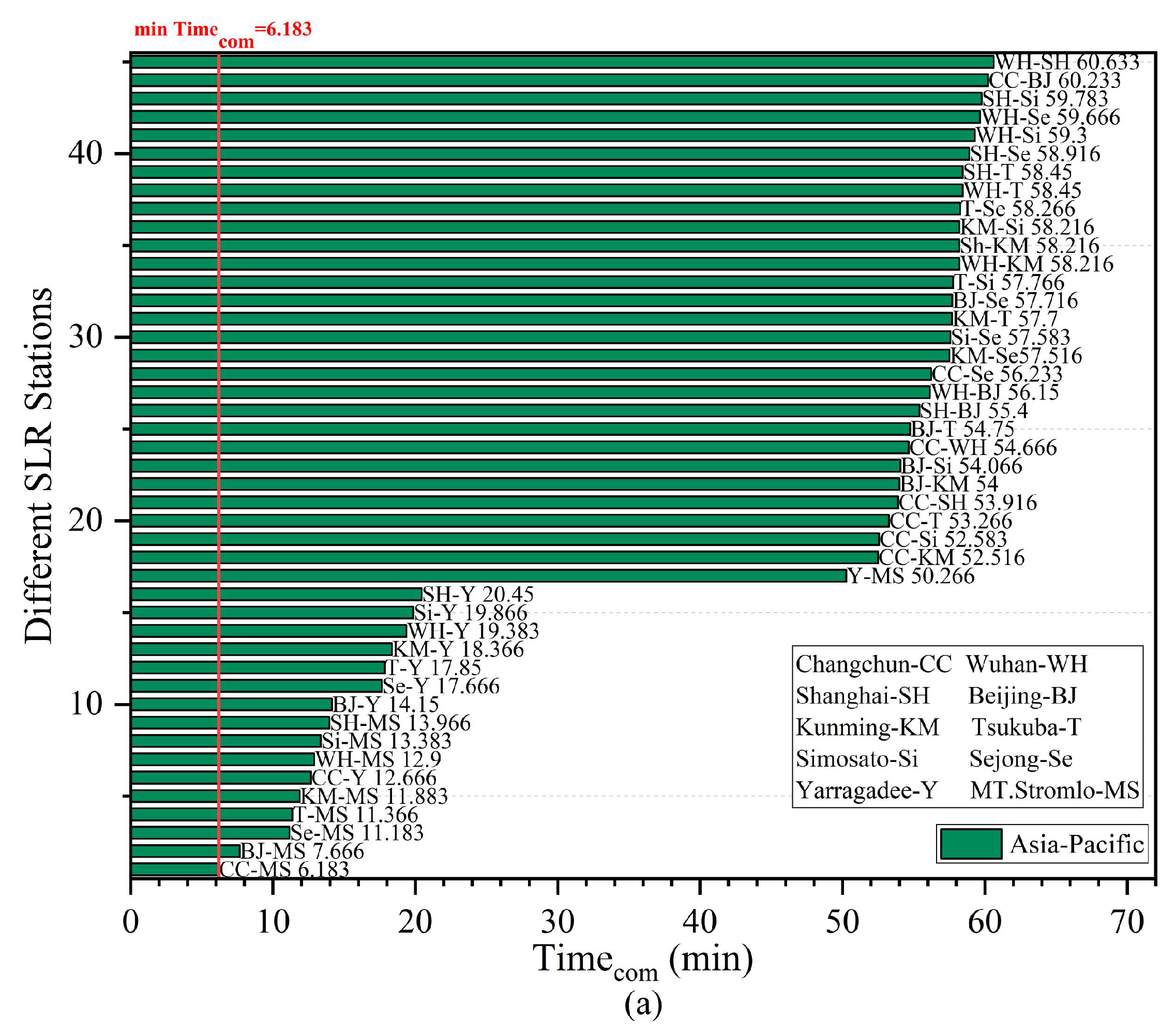
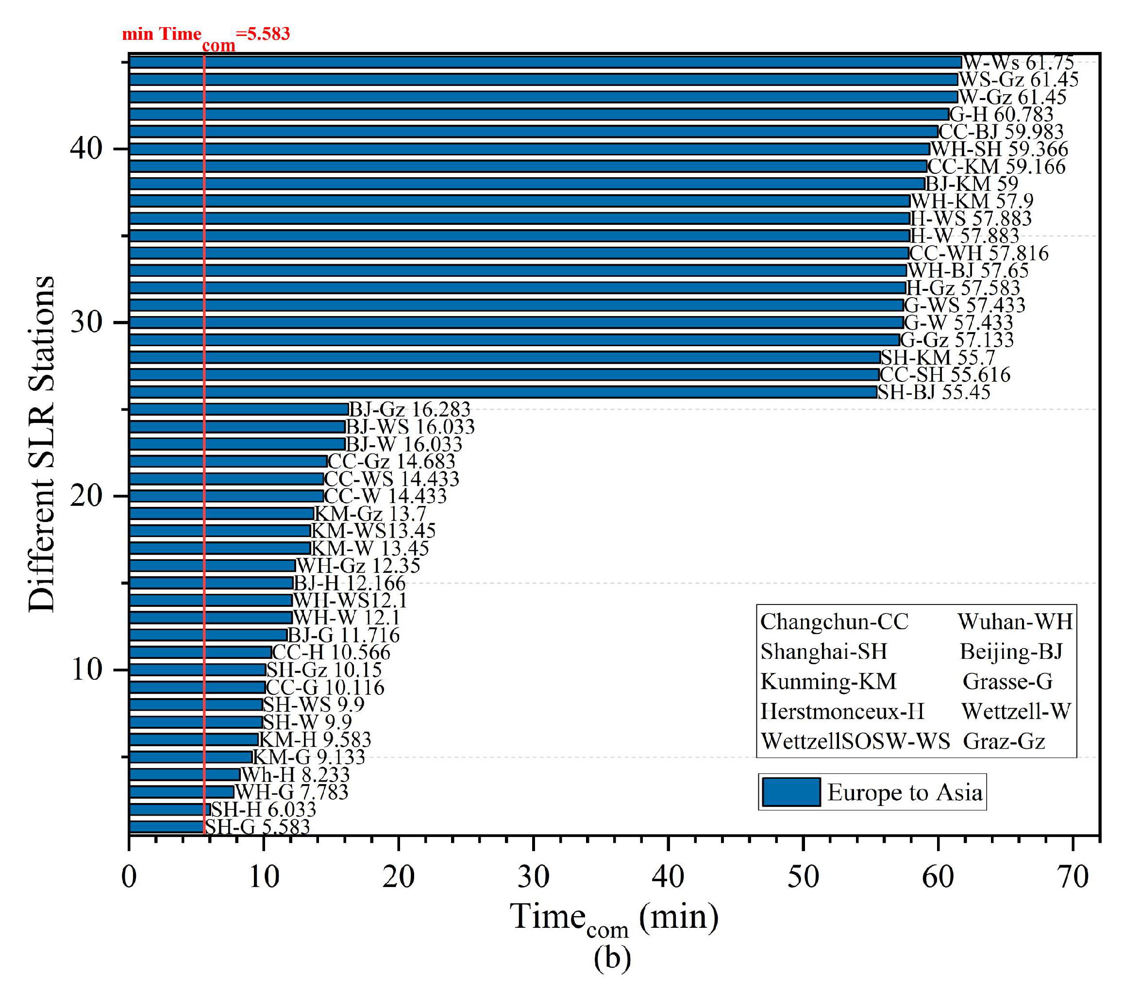
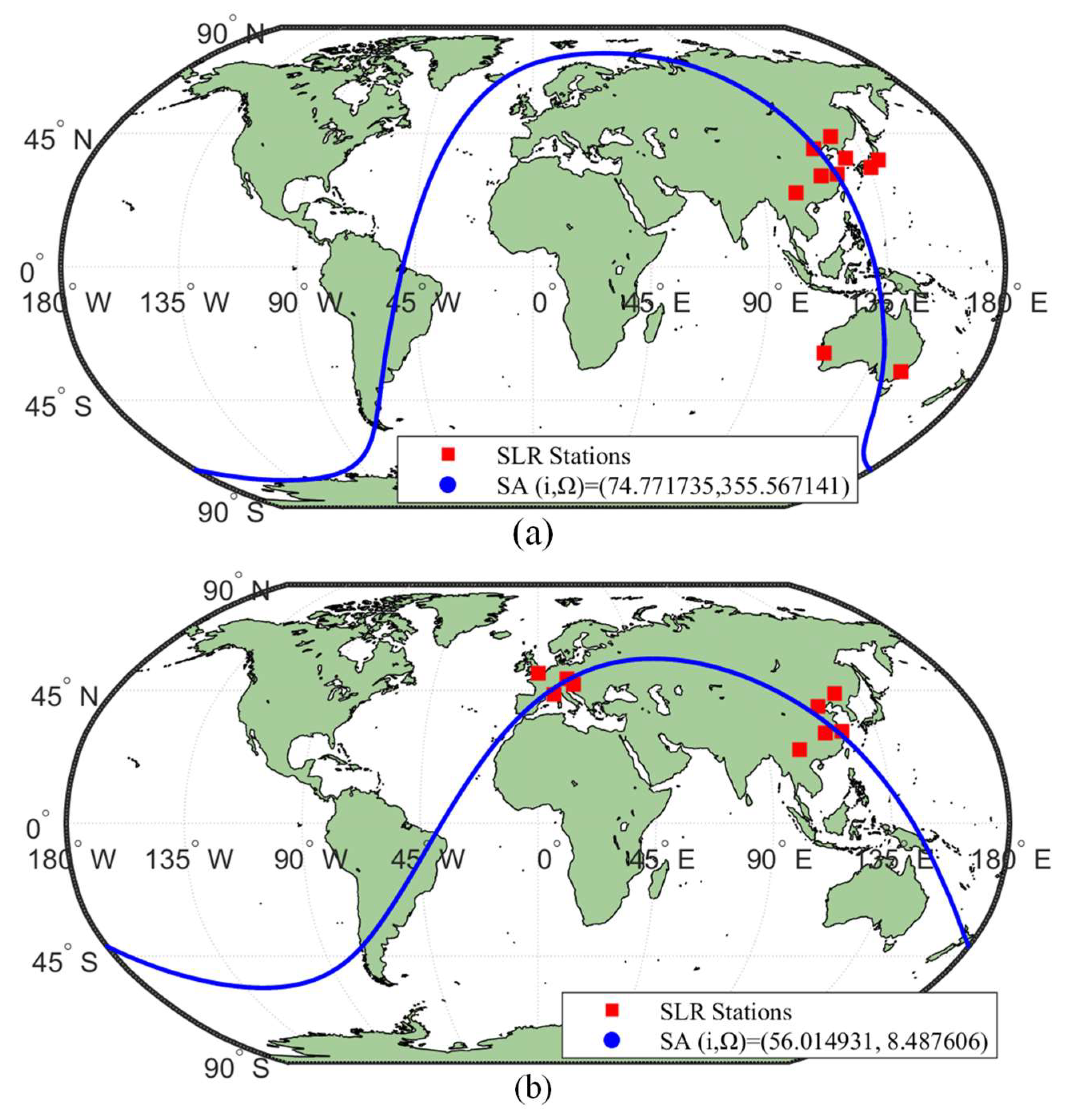
| Different SLR Stations | Improved Simulated Annealing | Particle Swarm Optimization | Conventional Iterative Traverse Method | |||
|---|---|---|---|---|---|---|
| CC WH (R = 7000 km) | 354 | (48.0322, 27.5481) | 354 | (47.9924, 27.6567) | 353 | (48.06, 27.40) |
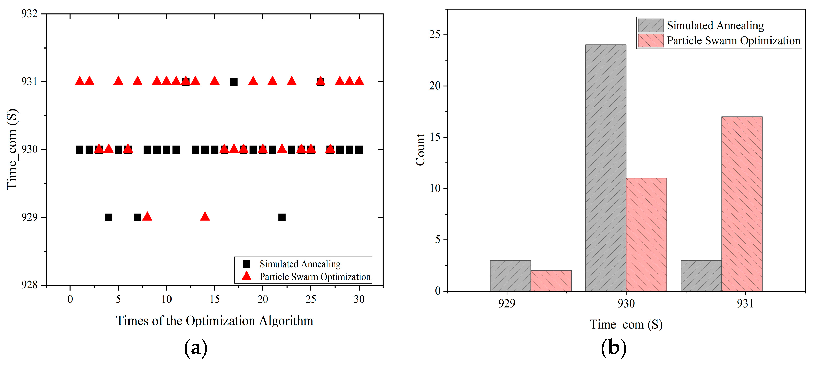
| CC WH (R = 8000 km) | 930 | (48.0299, 27.5674) | 931 | (48.0157, 27.6326) | 930 | (48.16, 27.55) |
| CC WH (R = 9000 km) | 1463 | (48.0008, 27.6434) | 1463 | (48.0612, 27.7097) | 1463 | (48.03, 27.51) |
| CC WH (R = 10,000 km) | 2009 | (48.0461, 27.6291) | 2009 | (48.0852, 27.6313) | 2009 | (48.05, 27.57) |
| Different SLR Stations | Improved Simulated Annealing | Particle Swarm Optimization | Conventional Iterative Traverse Method | |||
|---|---|---|---|---|---|---|
| Computation Time (min) | Computation Time (min) | Computation Time (min) | ||||
| CC WH (R = 7000 km) | 354 | 1.503 | 354 | 10.009 | 353 | 20.213 |
| CC WH (R = 8000 km) | 930 | 1.761 | 931 | 11.422 | 930 | 22.057 |
| CC WH (R = 9000 km) | 1463 | 2.165 | 1463 | 13.053 | 1463 | 26.895 |
| CC WH (R = 10,000 km) | 2009 | 2.941 | 2009 | 15.728 | 2009 | 31.804 |
| Altitude (km) | Satellite | Inclination (Degrees) | 10 Days | 10 Days | Multiplier | |
|---|---|---|---|---|---|---|
| 1336 | Jason-3 | 66 | 3.05 | 48.101305, 27.578522 | 27.313 | 8.955 |
| 1488 | Ajisai | 50 | 8.792 | 48.043023, 27.651744 | 29.339 | 3.337 |
| SLR Station | Coordinates X, Y, Z (km) | Latitude | Longitude | Height |
|---|---|---|---|---|
| 7237 Changchun | −2674.387, 3757.189, 4391.508 | 43.7905°N | 125.4434°E | 274.900 |
| 7396 Wuhan | −2279.756, 5004.737, 3219.791 | 30.515667°N | 114.490167°E | 76.7 |
| 7821 Shanghai | −2830.744, 4676.580, 3275.072 | 31.0961°N | 121.1866°E | 99.961 |
| 7249 Beijing | −2148.760, 4426.759, 4044.509 | 39.6069°N | 115.8920°E | 82.300 |
| 7819 Kunming | −1281.301, 5640.724, 2682.905 | 25.0298°N | 102.7977°E | 1987.05 |
| 7306 Tsukuba | −3961.641, 3308.774, 3308.774 | 36.0675°N | 140.1313°E | 68.21 |
| 7838 Simosato | −3822.388, 3699.363, 3507.573 | 33.5777°N | 135.9370°E | 62.44 |
| 7394 Sejong | −3110.108, 4082.170, 3774.911 | 36.520991°N | 127.302913°E | 176.415 |
| 7090 Yarragadee | −2389.008, 5043.332, −3078.526 | 29.0464°S | 115.3467°E | 244 |
| 7825 Mt. Stromlo | −4467.064, 2683.034, −3667.007 | 35.3161°S | 149.0099°E | 805.0 |
| SLR Station | Coordinates X, Y, Z (km) | Latitude | Longitude | Height |
|---|---|---|---|---|
| 7237 Changchun | −2674.387, 3757.189, 4391.508 | 43.7905°N | 125.4434°E | 274.9 |
| 7396 Wuhan | −2279.756, 5004.737, 3219.791 | 30.515667°N | 114.490167°E | 76.7 |
| 7821 Shanghai | −2830.744, 4676.580, 3275.072 | 31.0961°N | 121.1866°E | 99.9 |
| 7249 Beijing | −2148.760, 4426.759, 4044.509 | 39.6069°N | 115.8920°E | 82.3 |
| 7819 Kunming | −1281.301, 5640.724, 2682.905 | 25.0298°N | 102.7977°E | 1987.1 |
| 7845 Grasse | 4581.692, 556.196, 4389.355 | 43.7546°N | 6.9216°E | 1323.1 |
| 7840 Herstmonceux | 4033.463, 23.662, 4924.305 | 50.8674°N | 0.3361°E | 75.0 |
| 7827 WettzellSOSW | 4075.531, 931.781, 4801.619 | 49.1449402°N | 12.8781000°E | 663.1 |
| 8834 Wettzell | 4075.576, 931.785, 4801.583 | 49.1444°N | 12.8780°E | 665.0 |
| 7839 Graz | 4194.426, 1162.694, 4647.246 | 47.0671°N | 15.4933°E | 539.4 |
Disclaimer/Publisher’s Note: The statements, opinions and data contained in all publications are solely those of the individual author(s) and contributor(s) and not of MDPI and/or the editor(s). MDPI and/or the editor(s) disclaim responsibility for any injury to people or property resulting from any ideas, methods, instructions or products referred to in the content. |
© 2024 by the authors. Licensee MDPI, Basel, Switzerland. This article is an open access article distributed under the terms and conditions of the Creative Commons Attribution (CC BY) license (https://creativecommons.org/licenses/by/4.0/).
Share and Cite
Xue, H.; Zhang, Z.; Deng, S.; Mu, L.; Fu, J.; Diao, L. Improved Simulated Annealing Algorithm on the Design of Satellite Orbits for Common-View Laser Time Transfer. Remote Sens. 2024, 16, 472. https://doi.org/10.3390/rs16030472
Xue H, Zhang Z, Deng S, Mu L, Fu J, Diao L. Improved Simulated Annealing Algorithm on the Design of Satellite Orbits for Common-View Laser Time Transfer. Remote Sensing. 2024; 16(3):472. https://doi.org/10.3390/rs16030472
Chicago/Turabian StyleXue, Han, Ziang Zhang, Shiyu Deng, Liwei Mu, Jingqi Fu, and Lingtian Diao. 2024. "Improved Simulated Annealing Algorithm on the Design of Satellite Orbits for Common-View Laser Time Transfer" Remote Sensing 16, no. 3: 472. https://doi.org/10.3390/rs16030472
APA StyleXue, H., Zhang, Z., Deng, S., Mu, L., Fu, J., & Diao, L. (2024). Improved Simulated Annealing Algorithm on the Design of Satellite Orbits for Common-View Laser Time Transfer. Remote Sensing, 16(3), 472. https://doi.org/10.3390/rs16030472


