An Integrity Monitoring Method for Navigation Satellites Based on Multi-Source Observation Links
Abstract
1. Introduction
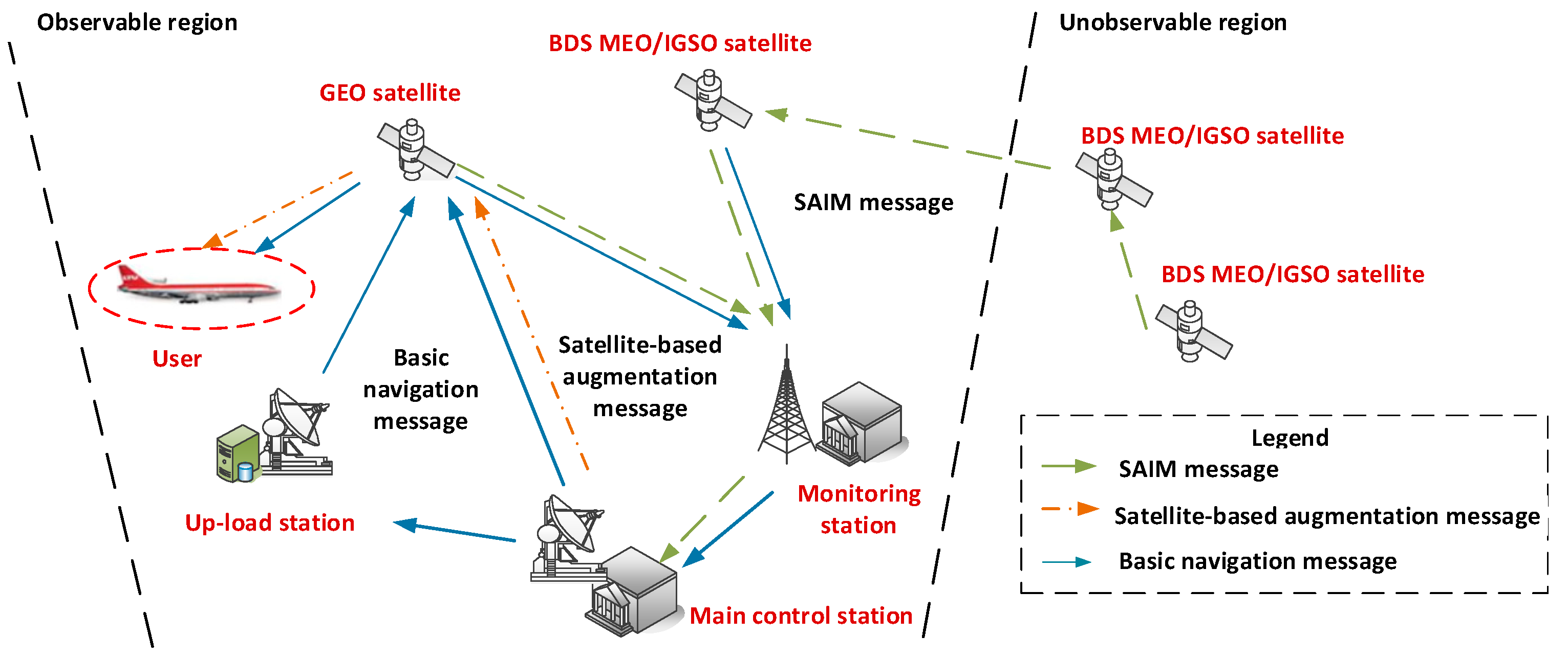
2. Systematic Integrity Design for BDS-3 Satellite
2.1. Integrity Monitoring System of BDS-3
2.2. Limitation of the Integrity Monitoring System
- (1)
- Layout of ground monitoring stations
- (2)
- Communication capacity of inter-satellite links
- (3)
- Monitoring content of systematic integrity
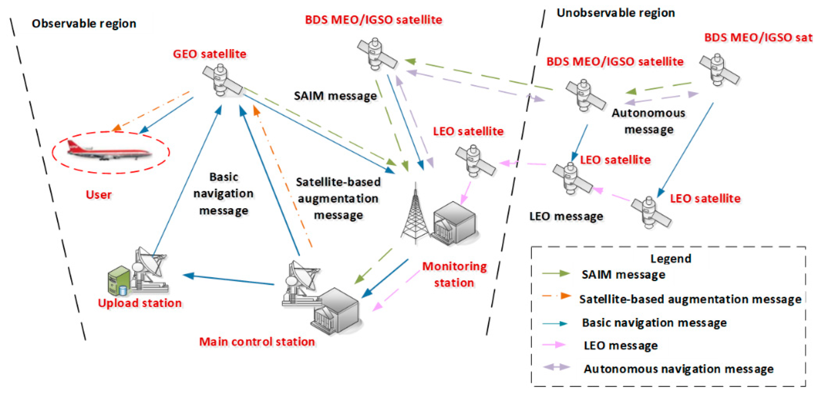
3. Design of Integrity Monitoring System with Multi-Source Observation Links
3.1. Demand Analysis
- (1)
- Extending monitoring area
- (2)
- Improving availability of integrity parameters
3.2. System Composition
3.3. Optimization Strategies of Observation Links
- (1)
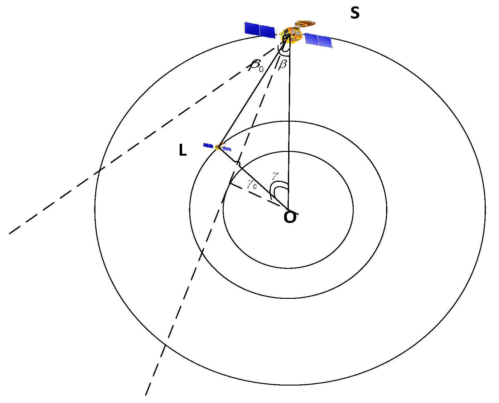
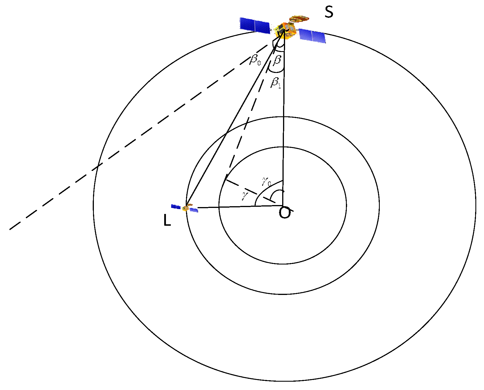
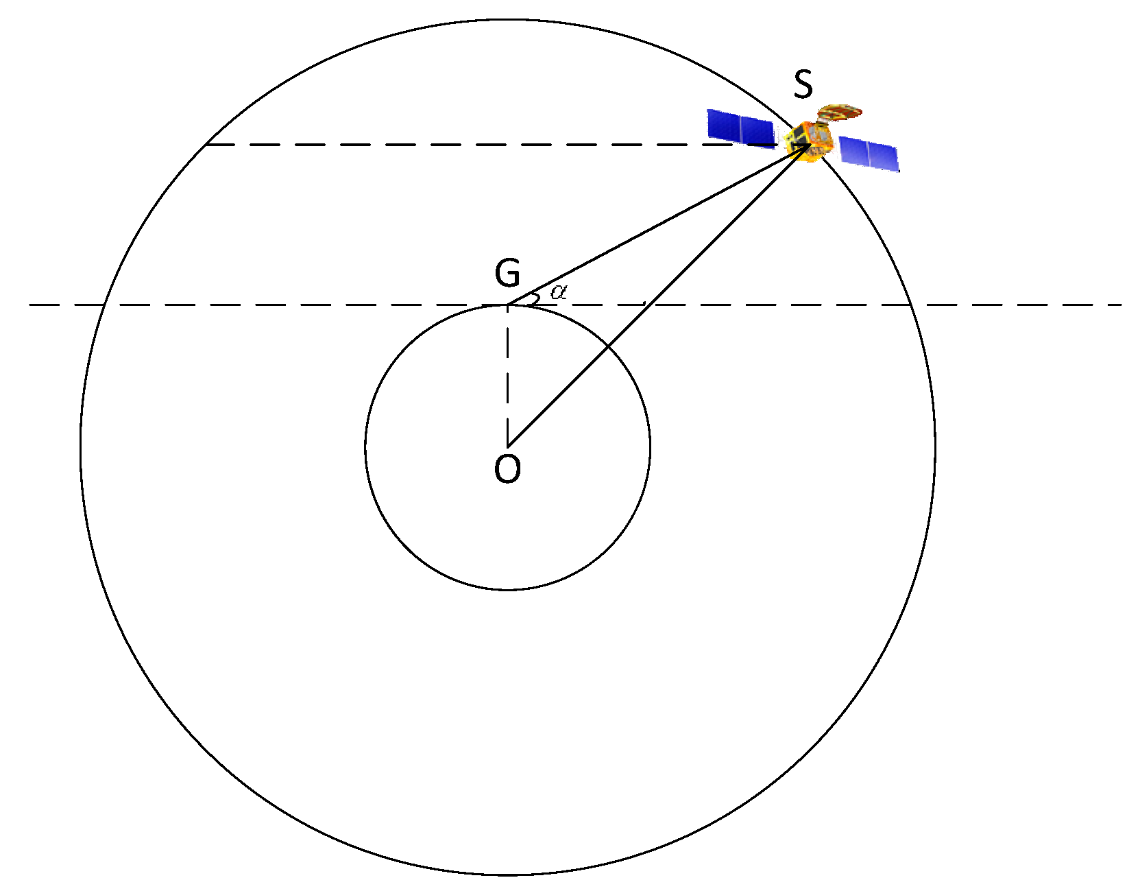
- Minimum satellite-based observation unit
- (2)
- Orbit determination observation unit
3.4. Monitoring Processing
- (1)
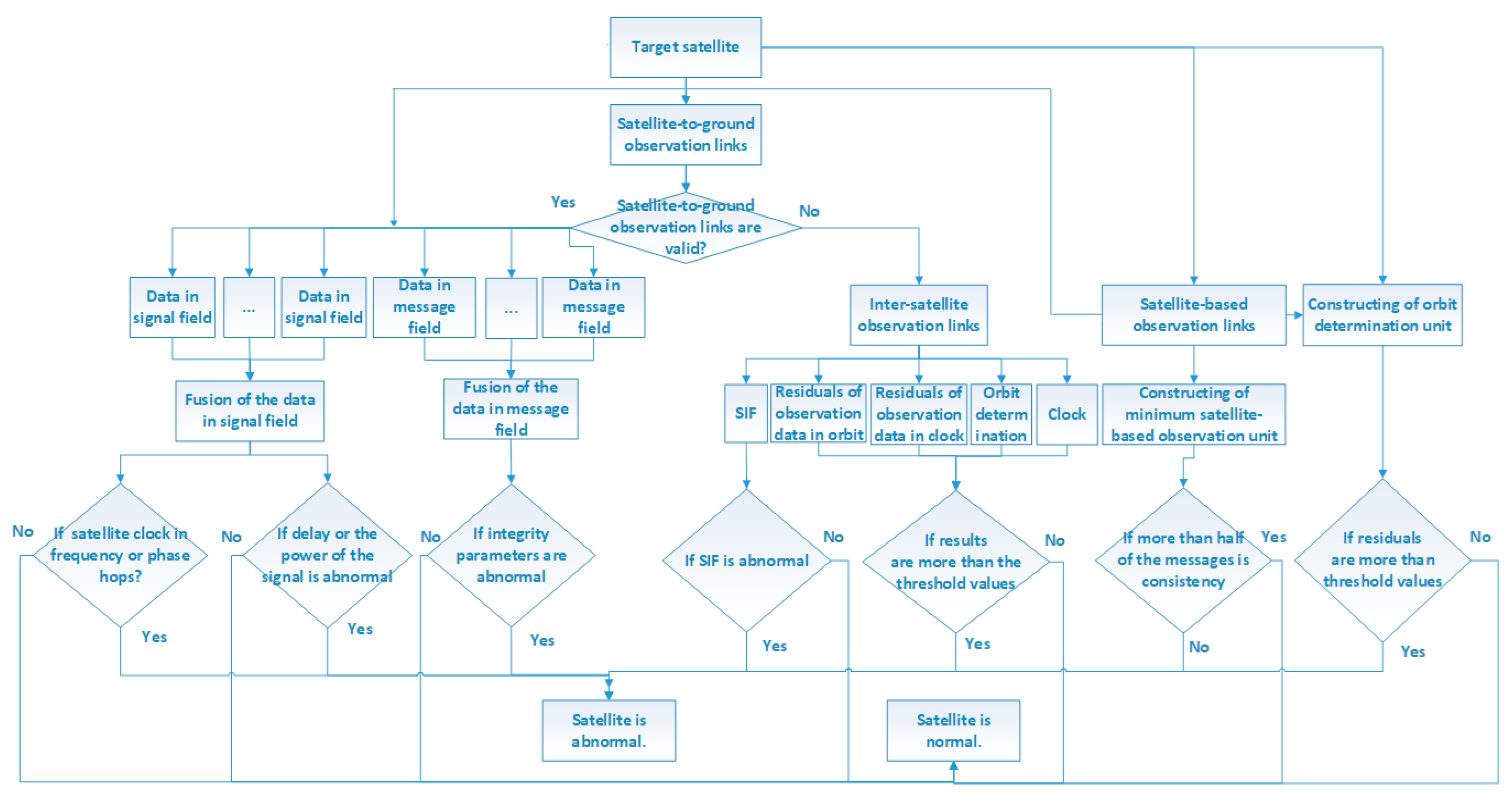
- Collecting observation data of the target satellite through satellite-to-ground, inter-satellite, and satellite-based observation links.
- (2)
- Constructing a minimum satellite-based observation unit whose is no less than M. The main control station gains the returned navigation messages through the minimum satellite-based observation unit. If more than half of returned navigation messages are inconsistent, the target satellite may be abnormal.
- (3)
- Constructing the orbit determination unit whose SPDOP is minimum and determining the orbit of the target satellite with the chosen observation links. If residuals of orbit determination exceed the threshold, the target satellite may be abnormal.
- (4)
- Estimating the integrity of the target satellite according to valid observation links.
- (1)
- When valid satellite-to-ground observation links are more than one, data in the signal field and message field should be synchronously collected by satellite-to-ground and satellite-based observation links. The data in the signal field mainly contains the state of the satellite clock, hopping indicators of frequency and phase in signal, and signal delay. Data in the message field mainly contain the messages mentioned in Table 1. Through fusion processing of multi-source observation data, the main control station can evaluate whether there are any anomalies in the target satellite and generate related integrity messages.
- (2)
- When there are no valid satellite-to-ground observation links, inter-satellite ranging data and autonomous navigation messages should be gained through inter-satellite links. The state of the target satellite can be judged by five kinds of information: SIF, residuals of observation data in orbit, residuals of observation in a clock, the difference value of orbit determination errors (), and the difference value of absolute clock errors (). If SIF, residuals of observation data, and/or difference value exceed the limitation, the target satellite may be abnormal.
3.5. Augmentation Parameters of Integrity with Multi-Source Observation Links
- (1)
- Augmentation parameter of orbit correction
- (2)
- Augmentation parameter of clock correction
- (3)
- User differential ranging error
4. Analysis of Optimization Strategies
4.1. Coverage Analysis of Satellite-Based Observation Unit
- (1)
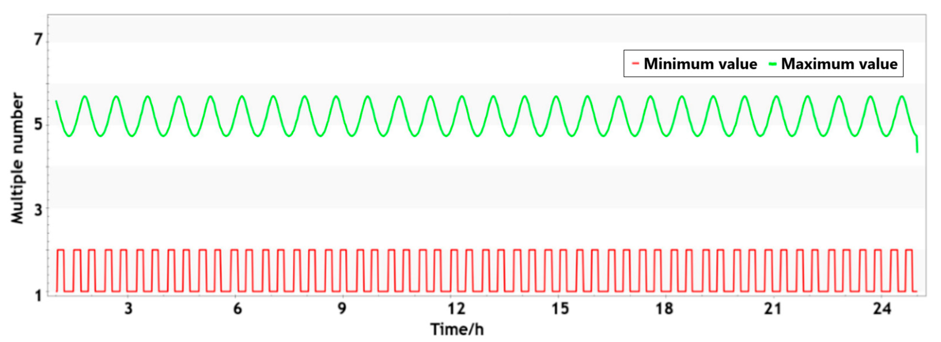
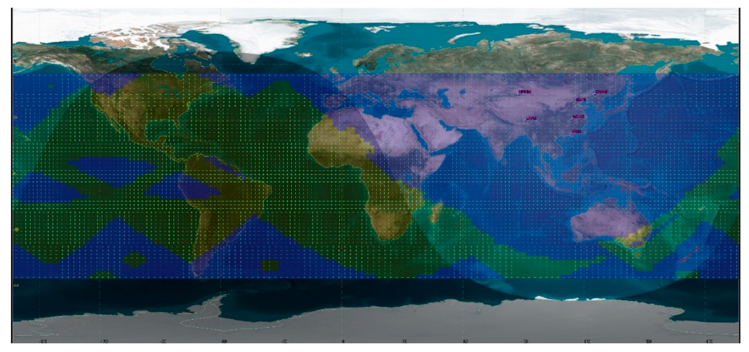
- is 3.47, 5.17, 10.36, and 18.75 in scenarios 2 to 5, respectively, which have nearly 1 time, 2 times, 5 times, and 10 times of improvement, respectively, compared with the results in scenario 1.
- (2)
- (3)
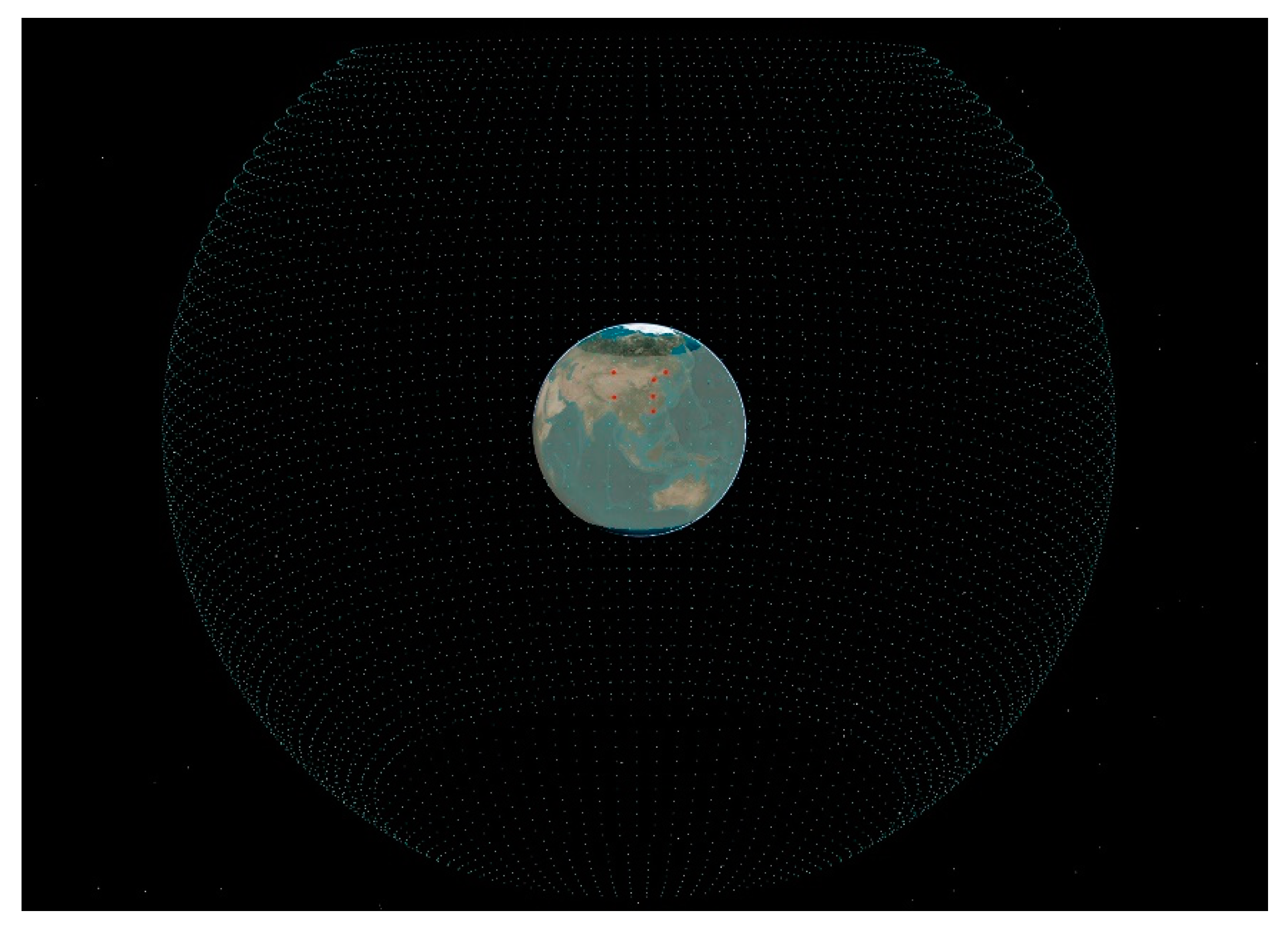
- With the support of 30 LEO satellites, the coverage rate of four-multiple numbers can reach 100%. That means any grid can be simultaneously monitored by more than four LEO satellites, making it possible to calculate integrity parameters in real time.
- (4)
- LEO satellites can effectively make up for the shortage of ground monitoring stations and realize real-time return of navigation messages for navigation satellites. Nevertheless, an increase in LEO satellites also brings the problem of data redundancy.
4.2. SPDOP Analysis of Orbit Determination Unit
- (1)
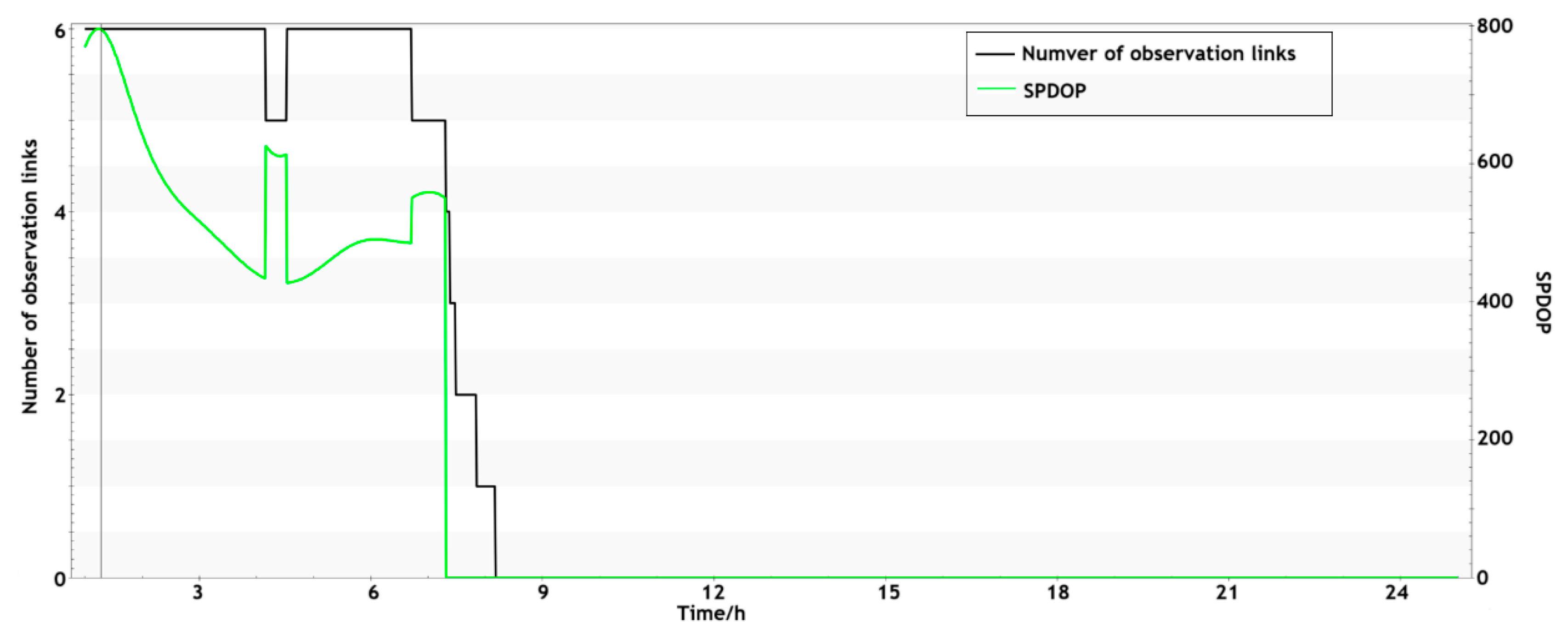
- In scenario 1, the valid number of observation links is only 1.60. The minimum and average values of SPDOP are 428.02 and 545.00, respectively, which is quite large even with the support of six stations synchronously, as shown in Figure 11.
- (2)
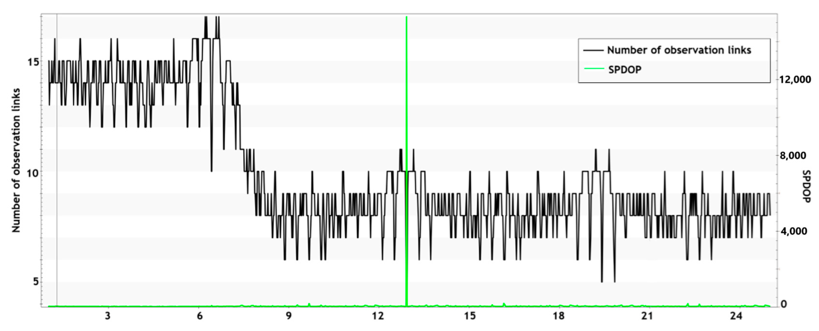
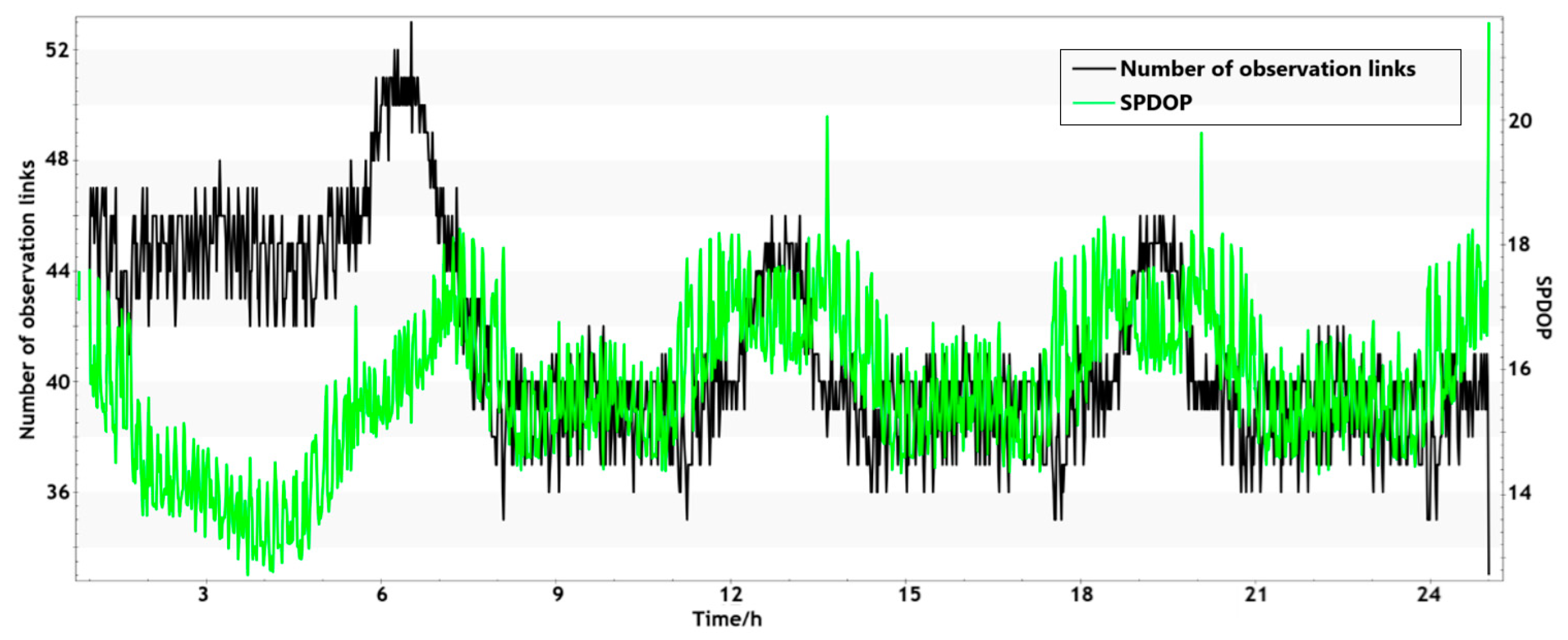
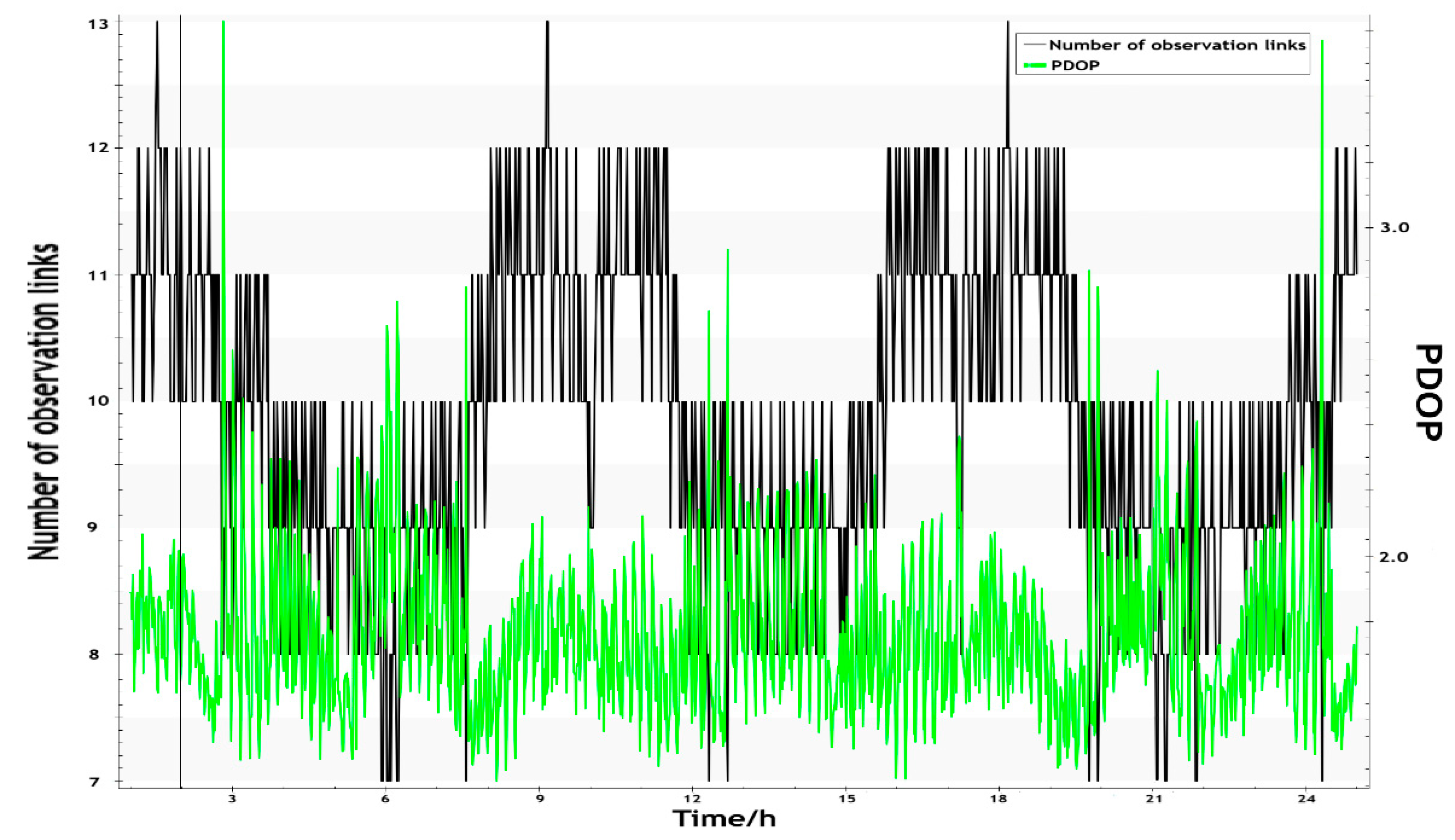
- As shown in Figure 12, Figure 13 and Figure 14, the value of SPDOP is respectively 38.37, 24.60, and 15.71, which could be improved by 92.95%, 95.49%, and 97.12% compared with the results in scenario 1. The value of SPDOP in scenario 2 changes greatly when the observation links are less than five. With the increasing number of LEO satellites, the augmentation effect of LEO satellites on SPDOP will gradually weaken. It means that a small number of LEO satellites can effectively improve the observation geometry the target satellite.
- (3)
- The minimum duration of observation links is respectively 10,250.36 s, 91.92 s, 46.75 s, and 10.45 s. Although the addition of LEO can effectively increase the number of observation links, it cannot guarantee continuous observation, which brings about the problem of frequent switching for observation links.
4.3. Performance Analysis of Integrity Parameter
- (1)
- The effective duration of UDRE is about 8.00 h, which is only 33.31% of the length of a single day because of the limitation of ground monitoring stations. The average simulation value of UDRE is 0.427 m, which is basically the same as the real performance of BDS-3.
- (2)
- With the support of 6, 12, or 60 LEO satellites, the effective duration of UDRE is respectively 16.11 h, 20.93 h, and 24 h, as shown in Table 5, meaning that the single-day effective rate is 67.11%, 87.19%, and 100%, respectively. As the number of LEO satellites increases, the area where UDRE parameters can be solved in real time can be gradually expanded to the global area, verifying that LEO satellites could be used as satellite-based monitoring stations to obtain more observation data.
- (3)
- The average value of UDRE is respectively 0.397 m, 0.388 m, and 0.351 m in scenarios 2 to 4, which have 7%, 9%, and 18% improvement compared with the results in scenario 1, verifying that the satellite-based observation data of LEO satellites could support the solution of UDRE.
- (4)
- (5)
- The service accuracy could be estimated using the product of PDOP and UDRE. As shown in Table 6, average service accuracy is respectively 0.93 m, 0.88 m, and 0.65 m in scenarios 2 to 4, which have 8.9%, 13.7%, and 36.3% improvement compared with the results in scenario 1. Although a small number of LEO satellites could not obviously improve the PDOP, the service accuracy could be effectively improved.
5. Conclusions
- (1)
- According to the observation conditions of the target satellite, the designed integrity monitoring system can conduct multi-dimensional monitoring in signal and message fields. In the signal field, the state of the satellite clock, hopping indicators of frequency and phase in signal, and signal delay should be monitored. In the message field, basic navigation messages, satellite-based augmentation messages, and autonomous messages should be considered comprehensively to evaluate the state of the target satellite. Indicator parameters, residuals of observation data, orbit determination errors, and clock errors can all indicate the state of the navigation satellite.
- (2)
- LEO satellites can effectively make up for the shortage of ground monitoring stations and realize real-time return of navigation messages for navigation satellites. With the support of 30 LEO satellites, the coverage rate of four-multiple numbers can reach 100%. This means that it does not matter where the target satellite is; it can be monitored by no less than four LEO satellites. A small amount of LEO satellites could realize full-arc monitoring of navigation satellites. For a large LEO constellation, it is necessary to construct a minimum observation unit for the effective return of navigation messages and to avoid data redundancy.
- (3)
- Realization of the orbit determination needs not only effective observation links but also reasonable observation geometry conditions. As the number of LEO satellites increases, the augmentation effect of LEO satellites to SPDOP would gradually weaken. The complexity of orbit determination would increase as more parameters are added to the normal equation of orbit errors, and more systematic errors would be brought in. Under the guarantee of effective observation links, it is an effective way to construct an orbit determination unit to optimize observation links and reduce equation dimension for fast calculation of satellite orbit.
- (4)
- LEO satellites can not only improve wide-area monitoring capability for navigation satellites but also augment the resolution accuracy of navigation messages. As the number of LEO satellites increases, the area where integrity parameters can be solved in real time is constantly expanding to a global area. With the support of 6, 12, or 60 LEO satellites, average service accuracy is respectively 0.93 m, 0.88 m, and 0.65 m, which has 8.9%, 13.7%, and 36.3% improvement compared with the result of regional service, verifying that LEO satellites have practical application values for augmentation of BDS-3 integrity monitoring.
Author Contributions
Funding
Data Availability Statement
Conflicts of Interest
References
- Cen, J.; Wang, M.; Qian, S. Analysis of modernization GNSS navigation message’s designing. J. Electron. Inf. Technol. 2011, 33, 211–216. [Google Scholar]
- Fan, M.; Zhou, J.; Niu, F.; Chang, Z. Analysis for satellite navigation system basic integrity algorithm and performance. J. Geomat. Sci. Technol. 2011, 28, 407–415. [Google Scholar]
- Li, Z.; Hao, J.; Li, J. Navigation message designing in Galileo OS SIS ICD. J. Geomat. Sci. Technol. 2011, 28, 14–18. [Google Scholar]
- China Satellite Navigation System Administration Office (CSNO). BeiDou Navigation Satellite System Signal in Space Interface Control Document: Open Service Signals B2a [EB/OL]. 23 February 2020. Available online: http://www.beidou.gov.cn/zt/xwfbh/wznfbh/gdxw3/201712/W020171226733918059992.pdf (accessed on 26 July 2024).
- China Satellite Navigation System Administration Office (CSNO). BeiDou Navigation Satellite System Signal In Space Interface Control Document: Open Service Signals B1C [EB/OL]. 23 February 2020. Available online: http://www.beidou.gov.cn/yw/xwzx/201712/W020171226734109267772.pdf (accessed on 26 July 2024).
- China Satellite Navigation System Administration Office (CSNO). BeiDou Navigation Satellite System Signal in Space Interface Control Document: Open Service Signals B3I [EB/OL]. 23 February 2020. Available online: http://www.beidou.gov.cn/xt/gfxz/201802/P020180209623601401189.pdf (accessed on 26 July 2024).
- Zhang, X.; Wu, M.; Liu, W.; Li, X.; Yu, S.; Lu, C.; Wickert, J. Initial assessment of the COMPASS/BeiDou-3: New-generation navigation signals. J. Geod. 2017, 91, 1225–1240. [Google Scholar] [CrossRef]
- Yang, Y. Concepts of comprehensive PNT and related key technologies. Acta Geod. Cartogr. Sin. 2016, 45, 505–510. [Google Scholar]
- Haines, B.; Bar-Sever, Y.; Bertiger, W.; Desai, S.; Willis, P. One-centimeter orbit determination for Jason-1: New GPS-based strategies. Mar. Geod. 2004, 27, 299–318. [Google Scholar] [CrossRef]
- Bock, H.; Jäggi, A.; Meyer, U.; Visser, P.; van den IJssel, J.; van Helleputte, T.; Heinze, M.; Hugentobler, U. GPS-derived orbits for the GOCE satellite. J. Geod. 2010, 85, 807–818. [Google Scholar] [CrossRef]
- Kang, Z.; Tapley, B.; Bettadpur, S.; Rim, H.; Nagel, P. Precise orbit determination for CHAMP using accelerometer data. Adv Astronaut. Sci. 2012, 112, 1405–1410. [Google Scholar]
- Xu, G.; Xu, J. On the singularity problem in orbital mechanics. Mon. Not. R. Astron. Soc. 2013, 429, 1139–1148. [Google Scholar] [CrossRef]
- Li, X.; Hu, X.; Guo, R.; Tang, C.; Liu, S.; Xin, J.; Guo, J.; Tian, Y.; Yang, Y.; Yang, J.; et al. Precise orbit determination for BDS-3 GEO satellites enhanced by intersatellite links. GPS Solut. 2022, 27, 8. [Google Scholar] [CrossRef]
- Yang, Y.; Yang, Y.; Hu, X.; Chen, J.; Guo, R.; Tang, C.; Zhou, S.; Zhao, L.; Xu, J. Inter-satellite link enhanced orbit determination for BeiDou-3. J. Navig. 2020, 73, 115–130. [Google Scholar] [CrossRef]
- Zhou, W.; Gao, W.; Lin, X.; Hu, X.; Ren, Q.; Tang, C. Emerging errors in the orientation of the constellation in GNSS autonomous orbit determination based on inter-satellite link measurement. Adv. Space Res. 2022, 70, 3156–3172. [Google Scholar] [CrossRef]
- Feng, L.; Mao, Y.; Song, X.; Sun, B. Analysis of the accuracy of Beidou combined orbit determination enhanced by LEO and ISL. Acta Geod. Et Cartogr. Sinica 2016, 45, 109–115. [Google Scholar]
- Shen, D.; Meng, Y.; Bian, L.; Lei, W.; Wang, Y.; Yan, T.; Xie, J. A global navigation augmentation system based on LEO communication constellation. J. Terahertz Sci. Electron. Inf. Technol. 2019, 17, 209–2014. [Google Scholar]


| Type | Integrity Parameter | Message Type | Signal | Update Cycle | Data Source | Service Object |
|---|---|---|---|---|---|---|
| Basic integrity parameters | SatH1 | D1 | B1I/B3I | 30 s | Main control station | Global user |
| D2 | 3 s | |||||
| HS | B-CNAV1 | B1C | 18 s | Main control station/ satellite | ||
| B-CNAV2 | B2a | 3 s | ||||
| Hea | D1 | B1I/B3I | 30 s | Main control station | ||
| D2 | 3 s | |||||
| Health | B-CNAV1 | B1C | 18 s | |||
| B-CNAV2 | B2a | 3 s | ||||
| RURA | D2 | B1I/B3I | 18 s | |||
| SISMAI/SISAI/ DIF, SIF, AIF | B-CNAV1 | B1C | 30s/360s/changing time | Main control station/ satellite | ||
| B-CNAV2 | B2a | |||||
| Augmentation integrity parameters | UDREI | D2 | B1I/B3I | 3 s | Main control station | Regional user |
| B-CINAV | BDSBAS-B1C | 6 s | ||||
| GIVEI | D2 | B1I/B3I | 180 s/360 s | |||
| B-CINAV | BDSBAS-B1C | 240 s | ||||
| DFREI | B-CINAV | BDSBAS-B2a | 6s/alarm time | |||
| DFRECI | B-CINAV | BDSBAS-B2a | 6s/alarm time |
| Scenario | Monitoring Points | Multiple Number | Coverage Rate of M-Multiple Number | ||||
|---|---|---|---|---|---|---|---|
| ≥1 | ≥4 | ||||||
| Min | Ave | Min | Ave | ||||
| 1 | Six ground monitoring stations | 0 | 1.77 | 0 | 41.37 | 0 | 27.96 |
| 2 | Six ground monitoring stations + six LEO satellites (Walker 60/6/1, each orbital plane chooses one satellite) | 0 | 3.47 | 68.26 | 87.50 | 33.26 | 37.10 |
| 3 | Six ground monitoring stations + 12 LEO satellites (Walker 60/6/1, each orbital plane chooses two satellites) | 1 | 5.17 | 100 | 100 | 44.46 | 68.98 |
| 4 | Six ground monitoring stations + 30 LEO satellites (Walker30/6/1) | 4 | 10.36 | 100 | 100 | 100 | 100 |
| 5 | Six ground monitoring stations + 60 LEO satellites (Walker60/6/1) | 11 | 18.75 | 100 | 100 | 100 | 100 |
| Scenario | Monitoring Points | SPDOP | Number of Observation Links | Duration of Observation Links | |||
|---|---|---|---|---|---|---|---|
| Min | Ave | Min | Ave | Min | Ave | ||
| 1 | Six ground monitoring stations | 428.02 | 545.00 | 0 | 1.60 | 10,250.36 | 19,800.80 |
| 2 | Six ground monitoring stations + 30 LEO satellite (Walker30/6/1) | 21.09 | 38.37 | 4 | 9.94 | 91.92 | 2000.98 |
| 3 | Six ground monitoring stations + 60 LEO satellite (Walker60/6/1) | 17.14 | 24.60 | 12 | 18.26 | 46.75 | 1849.72 |
| 4 | Six ground monitoring stations + 144 LEO satellite (Walker144/12/1) | 13.04 | 15.71 | 33 | 41.29 | 10.45 | 1878.55 s |
| Scenario | Monitoring Points |
|---|---|
| 1 | Six ground monitoring stations |
| 2 | Six ground monitoring stations + 6 LEO satellite (Walker 60/6/1, each orbital plane chooses one satellite) |
| 3 | Six ground monitoring stations + 12 LEO satellite (Walker 60/6/1, each orbital plane chooses two satellites) |
| 4 | Six ground monitoring stations + 60 LEO satellite (Walker 60/6/1) |
| PRN | Scenario 1 | Scenario 2 | Scenario 3 | Scenario 4 | ||||||||
|---|---|---|---|---|---|---|---|---|---|---|---|---|
| Duration (h) | Rate | UDRE (m) | Duration (h) | Rate | UDRE (m) | Duration (h) | Rate | UDRE (m) | Duration (h) | Rate | UDRE (m) | |
| C19 | 8.09 | 33.71% | 0.476 | 13.44 | 56.00% | 0.435 | 21.54 | 89.75% | 0.347 | 24 | 100% | 0.355 |
| C20 | 7.47 | 31.13% | 0.474 | 14.76 | 61.50% | 0.359 | 19.86 | 82.75% | 0.454 | 24 | 100% | 0.288 |
| C21 | 5.90 | 24.58% | 0.411 | 13.56 | 56.50% | 0.423 | 18.93 | 78.88% | 0.364 | 24 | 100% | 0.336 |
| C22 | 7.08 | 29.50% | 0.458 | 16.17 | 67.38% | 0.420 | 22.16 | 92.33% | 0.340 | 24 | 100% | 0.310 |
| C23 | 8.14 | 33.92% | 0.372 | 15.76 | 65.67% | 0.341 | 20.83 | 86.79% | 0.349 | 24 | 100% | 0.403 |
| C24 | 8.51 | 35.46% | 0.467 | 16.89 | 70.38% | 0.334 | 19.74 | 82.25% | 0.405 | 24 | 100% | 0.332 |
| C25 | 9.76 | 40.67% | 0.347 | 18.64 | 77.67% | 0.395 | 21.68 | 90.33% | 0.383 | 24 | 100% | 0.364 |
| C26 | 7.54 | 31.42% | 0.390 | 15.87 | 66.13% | 0.468 | 20.16 | 84.00% | 0.364 | 24 | 100% | 0.311 |
| C27 | 8.09 | 33.71% | 0.349 | 14.99 | 62.46% | 0.370 | 19.78 | 82.42% | 0.438 | 24 | 100% | 0.375 |
| C28 | 8.16 | 34.00% | 0.358 | 15.67 | 65.29% | 0.408 | 21.07 | 87.79% | 0.400 | 24 | 100% | 0.325 |
| C29 | 7.98 | 33.25% | 0.488 | 15.91 | 66.29% | 0.351 | 19.49 | 81.21% | 0.395 | 24 | 100% | 0.382 |
| C30 | 10.03 | 41.79% | 0.465 | 18.76 | 78.17% | 0.435 | 22.83 | 95.13% | 0.452 | 24 | 100% | 0.387 |
| C32 | 7.68 | 32.00% | 0.398 | 15.38 | 64.08% | 0.356 | 20.47 | 85.29% | 0.354 | 24 | 100% | 0.396 |
| C33 | 7.09 | 29.54% | 0.511 | 16.16 | 67.33% | 0.396 | 21.64 | 90.17% | 0.427 | 24 | 100% | 0.352 |
| C34 | 8.63 | 35.96% | 0.347 | 17.48 | 72.83% | 0.427 | 22.09 | 92.04% | 0.426 | 24 | 100% | 0.298 |
| C35 | 7.65 | 31.88% | 0.419 | 15.73 | 65.54% | 0.457 | 20.95 | 87.29% | 0.369 | 24 | 100% | 0.320 |
| C36 | 6.09 | 25.38% | 0.409 | 14.15 | 58.96% | 0.468 | 19.72 | 82.17% | 0.398 | 24 | 100% | 0.420 |
| C37 | 7.98 | 33.25% | 0.478 | 15.88 | 66.17% | 0.402 | 22.39 | 93.29% | 0.321 | 24 | 100% | 0.309 |
| C41 | 6.59 | 27.46% | 0.483 | 14.07 | 58.63% | 0.338 | 20.96 | 87.33% | 0.318 | 24 | 100% | 0.408 |
| C42 | 7.69 | 32.04% | 0.374 | 16.85 | 70.21% | 0.339 | 21.33 | 88.88% | 0.392 | 24 | 100% | 0.365 |
| C43 | 10.34 | 43.08% | 0.428 | 18.83 | 78.46% | 0.356 | 20.69 | 86.21% | 0.430 | 24 | 100% | 0.433 |
| C44 | 9.57 | 39.88% | 0.421 | 18.63 | 77.63% | 0.449 | 22.05 | 91.88% | 0.454 | 24 | 100% | 0.298 |
| C45 | 8.19 | 34.13% | 0.456 | 17.48 | 72.83% | 0.356 | 21.93 | 91.38% | 0.330 | 24 | 100% | 0.351 |
| C46 | 7.64 | 31.83% | 0.468 | 15.47 | 64.46% | 0.445 | 19.91 | 82.96% | 0.398 | 24 | 100% | 0.302 |
| Average | 8.00 | 33.31% | 0.427 | 16.11 | 67.11% | 0.397 | 20.93 | 87.19% | 0.388 | 24 | 100% | 0.351 |
| Scenario | BJFS | CHAN | HKSL | LHAZ | URUM | WUH2 | Average | |||||||
|---|---|---|---|---|---|---|---|---|---|---|---|---|---|---|
| PDOP | Service Accuracy (m) | PDOP | Service Accuracy (m) | PDOP | Service Accuracy (m) | PDOP | Service Accuracy (m) | PDOP | Service Accuracy (m) | PDOP | Service Accuracy (m) | PDOP | Service Accuracy (m) | |
| 1 | 2.32 | 0.99 | 2.36 | 1.01 | 2.36 | 1.01 | 2.39 | 1.02 | 2.41 | 1.03 | 2.40 | 1.02 | 2.37 | 1.02 |
| 2 | 2.26 | 0.90 | 2.29 | 0.91 | 2.31 | 0.92 | 2.32 | 0.92 | 2.34 | 0.93 | 2.33 | 0.93 | 2.31 | 0.93 |
| 3 | 2.19 | 0.85 | 2.22 | 0.86 | 2.27 | 0.88 | 2.26 | 0.88 | 2.20 | 0.85 | 2.28 | 0.88 | 2.24 | 0.88 |
| 4 | 1.76 | 0.62 | 1.77 | 0.62 | 1.96 | 0.69 | 1.86 | 0.65 | 1.77 | 0.62 | 1.86 | 0.65 | 1.83 | 0.65 |
Disclaimer/Publisher’s Note: The statements, opinions and data contained in all publications are solely those of the individual author(s) and contributor(s) and not of MDPI and/or the editor(s). MDPI and/or the editor(s) disclaim responsibility for any injury to people or property resulting from any ideas, methods, instructions or products referred to in the content. |
© 2024 by the authors. Licensee MDPI, Basel, Switzerland. This article is an open access article distributed under the terms and conditions of the Creative Commons Attribution (CC BY) license (https://creativecommons.org/licenses/by/4.0/).
Share and Cite
Xin, J.; Wang, D.; Li, K. An Integrity Monitoring Method for Navigation Satellites Based on Multi-Source Observation Links. Remote Sens. 2024, 16, 4574. https://doi.org/10.3390/rs16234574
Xin J, Wang D, Li K. An Integrity Monitoring Method for Navigation Satellites Based on Multi-Source Observation Links. Remote Sensing. 2024; 16(23):4574. https://doi.org/10.3390/rs16234574
Chicago/Turabian StyleXin, Jie, Dongxia Wang, and Kai Li. 2024. "An Integrity Monitoring Method for Navigation Satellites Based on Multi-Source Observation Links" Remote Sensing 16, no. 23: 4574. https://doi.org/10.3390/rs16234574
APA StyleXin, J., Wang, D., & Li, K. (2024). An Integrity Monitoring Method for Navigation Satellites Based on Multi-Source Observation Links. Remote Sensing, 16(23), 4574. https://doi.org/10.3390/rs16234574


