
Land Subsidence Detection Using SBAS- and Stacking-InSAR with Zonal Statistics and Topographic Correlations in Lakhra Coal Mines, Pakistan


Abstract
1. Introduction
2. Materials and Methods
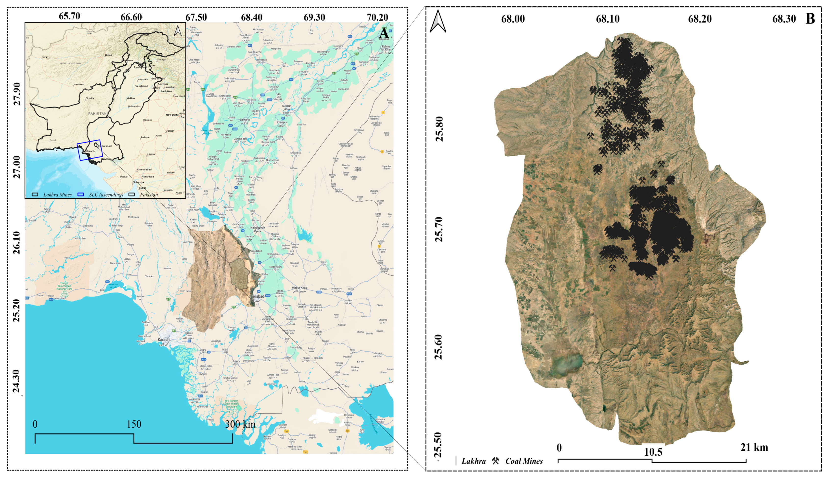
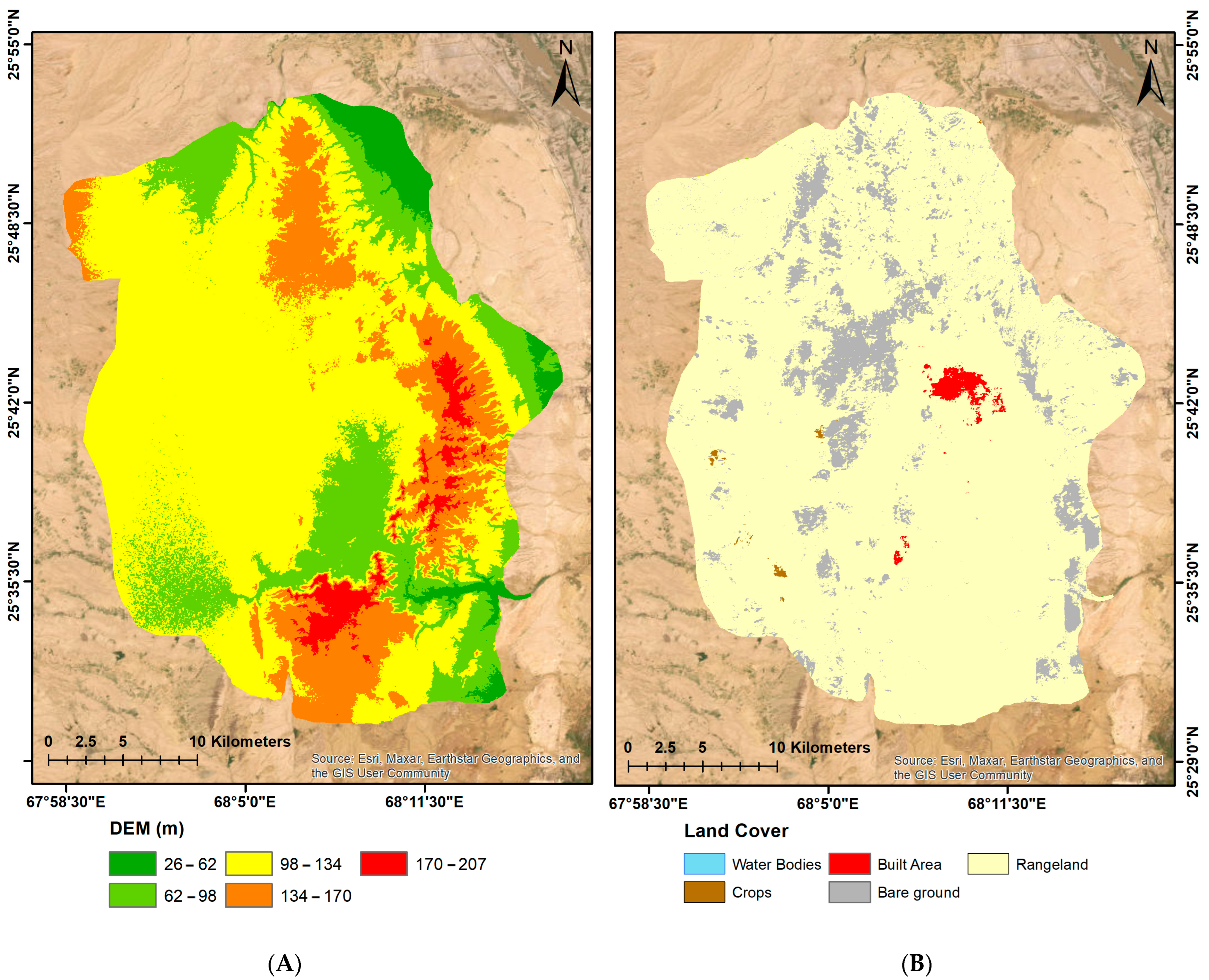
2.1. Study Area
2.2. Dataset
2.3. InSAR Process
3. Results
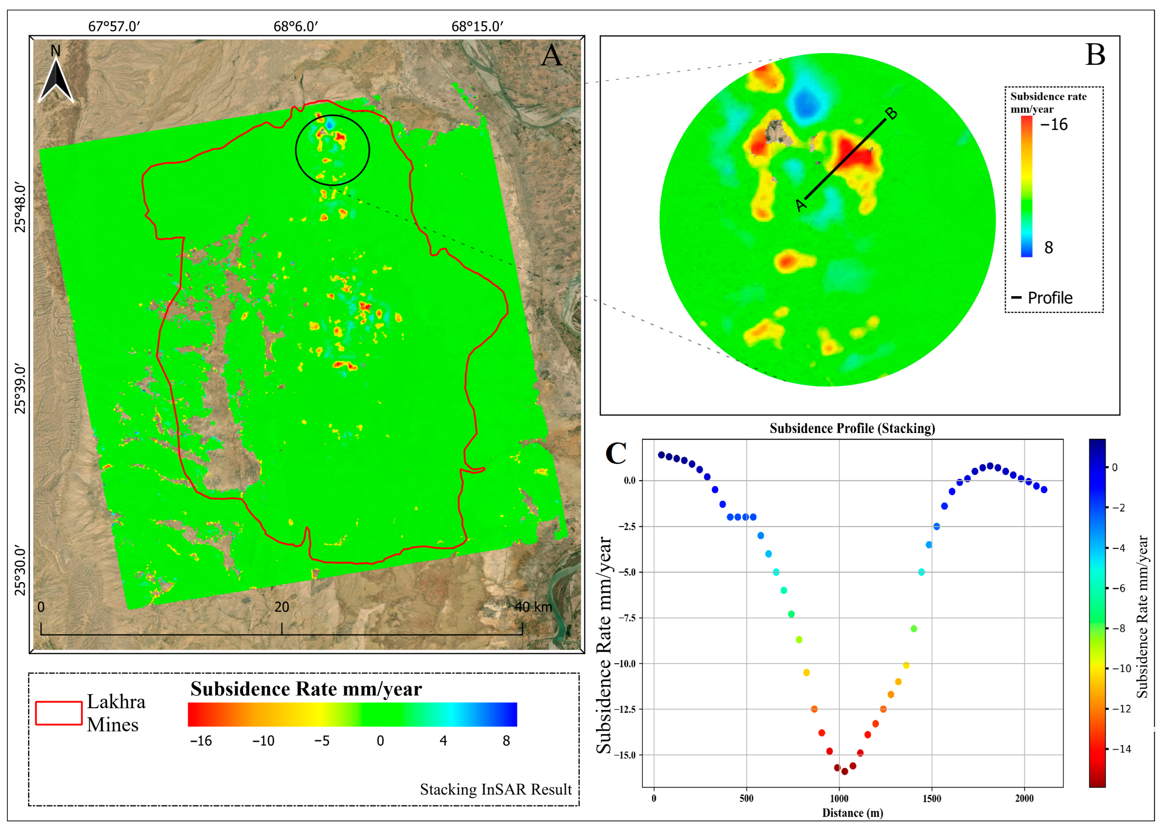
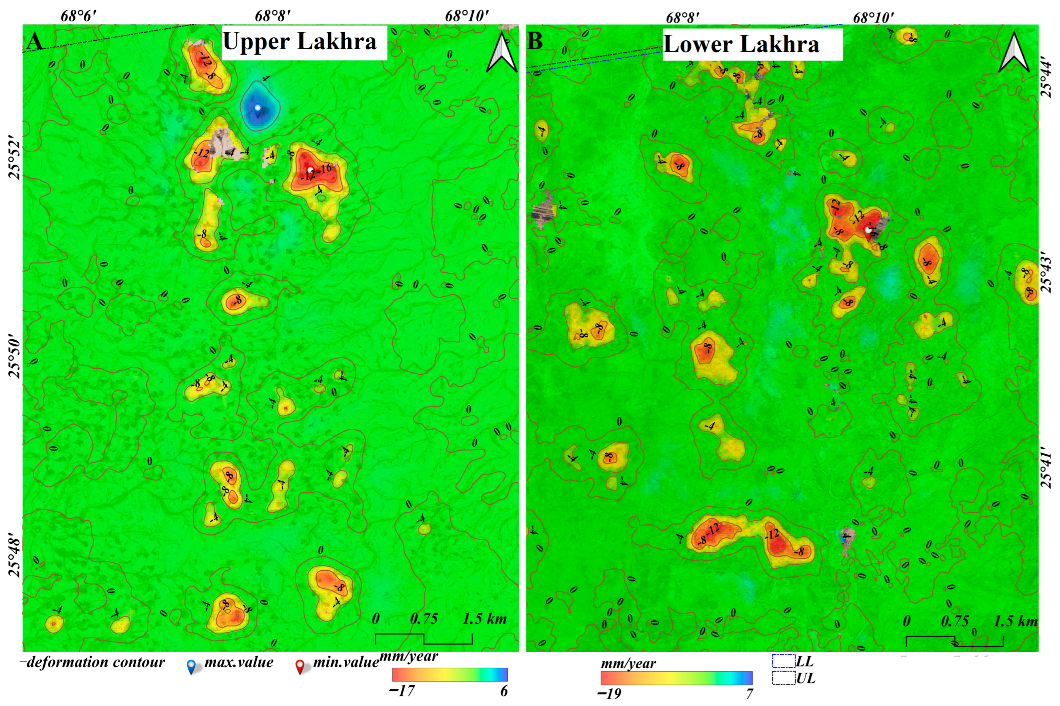
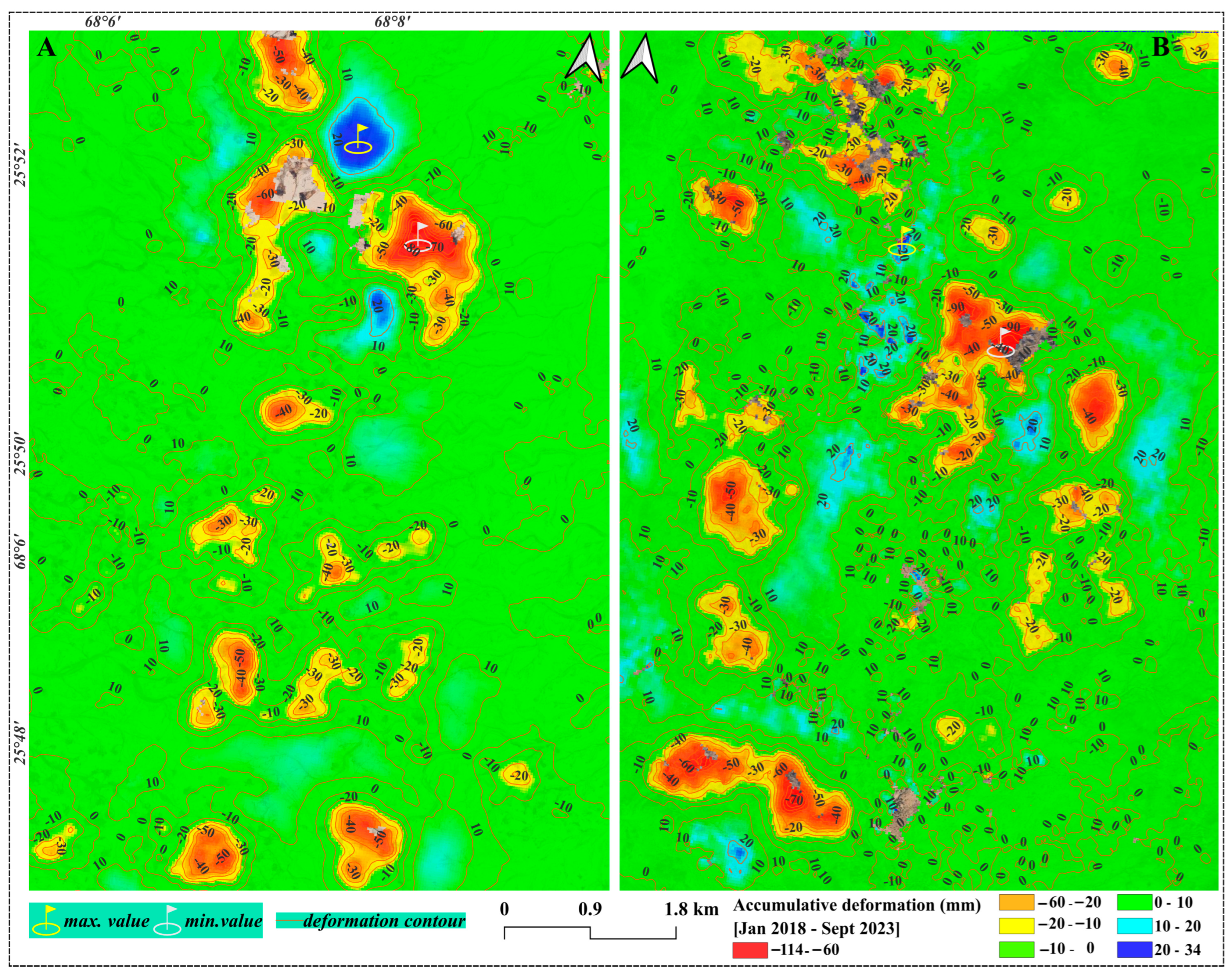
3.1. Stacking-InSAR Results
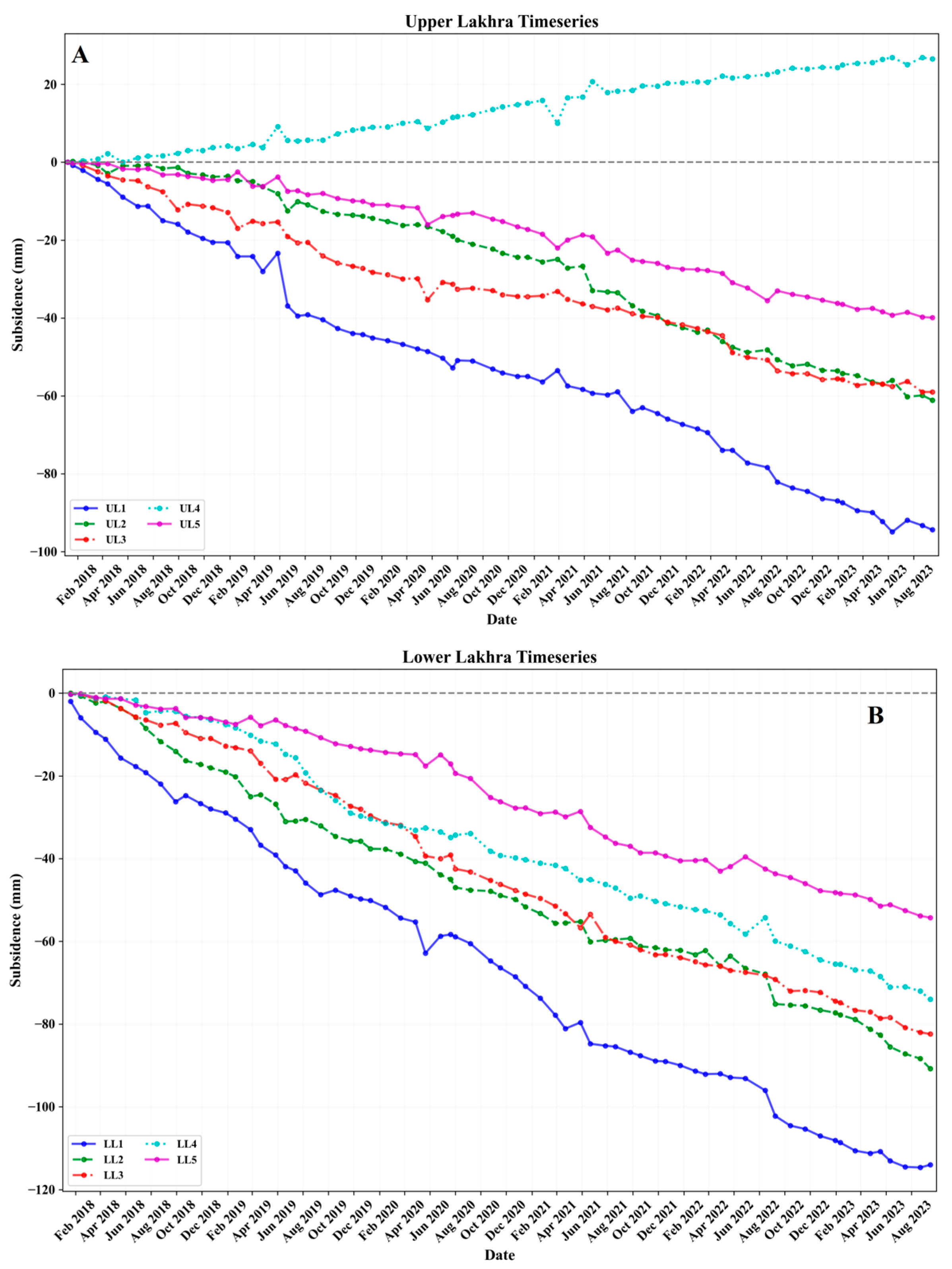
3.2. SBAS-InSAR and Time Series
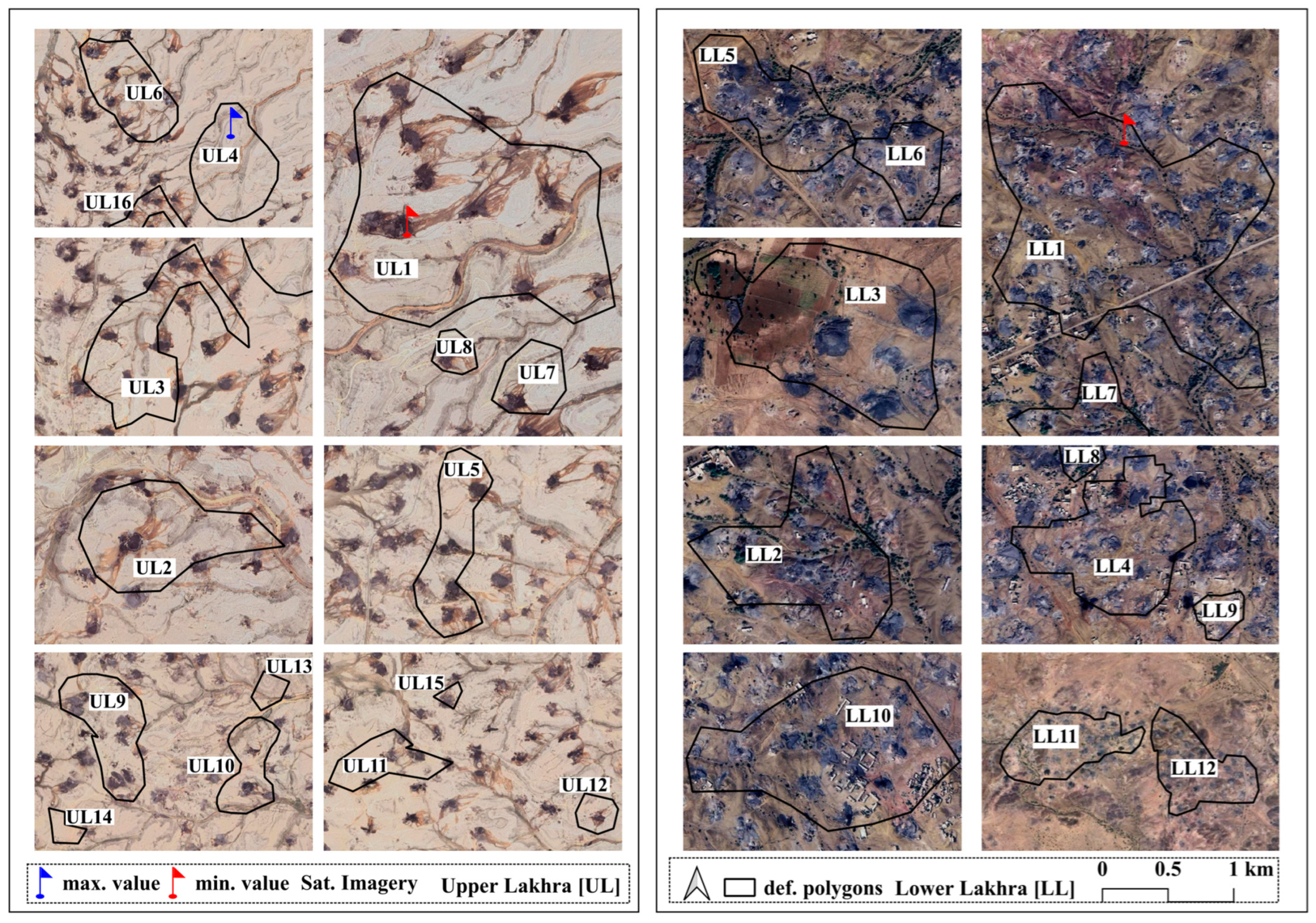
3.3. Zonal Statistics and Quantitative Analysis
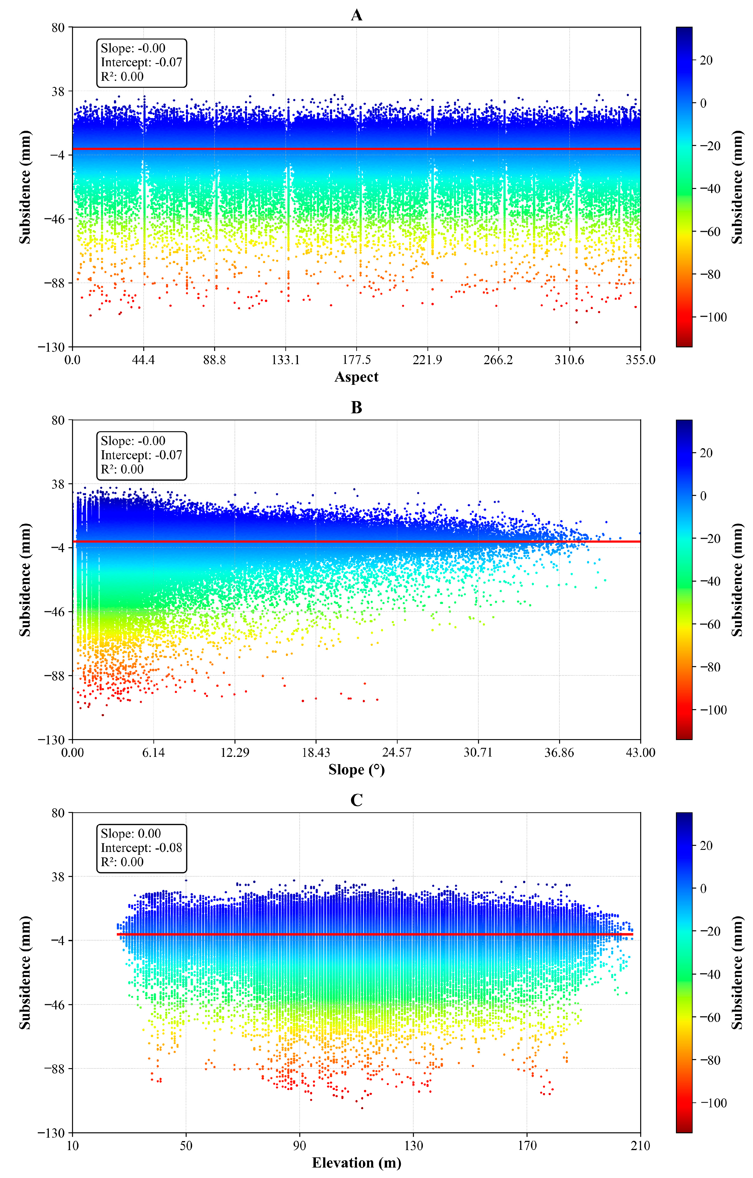
3.4. Connection between Topographical Elements and Deformation
4. Discussion
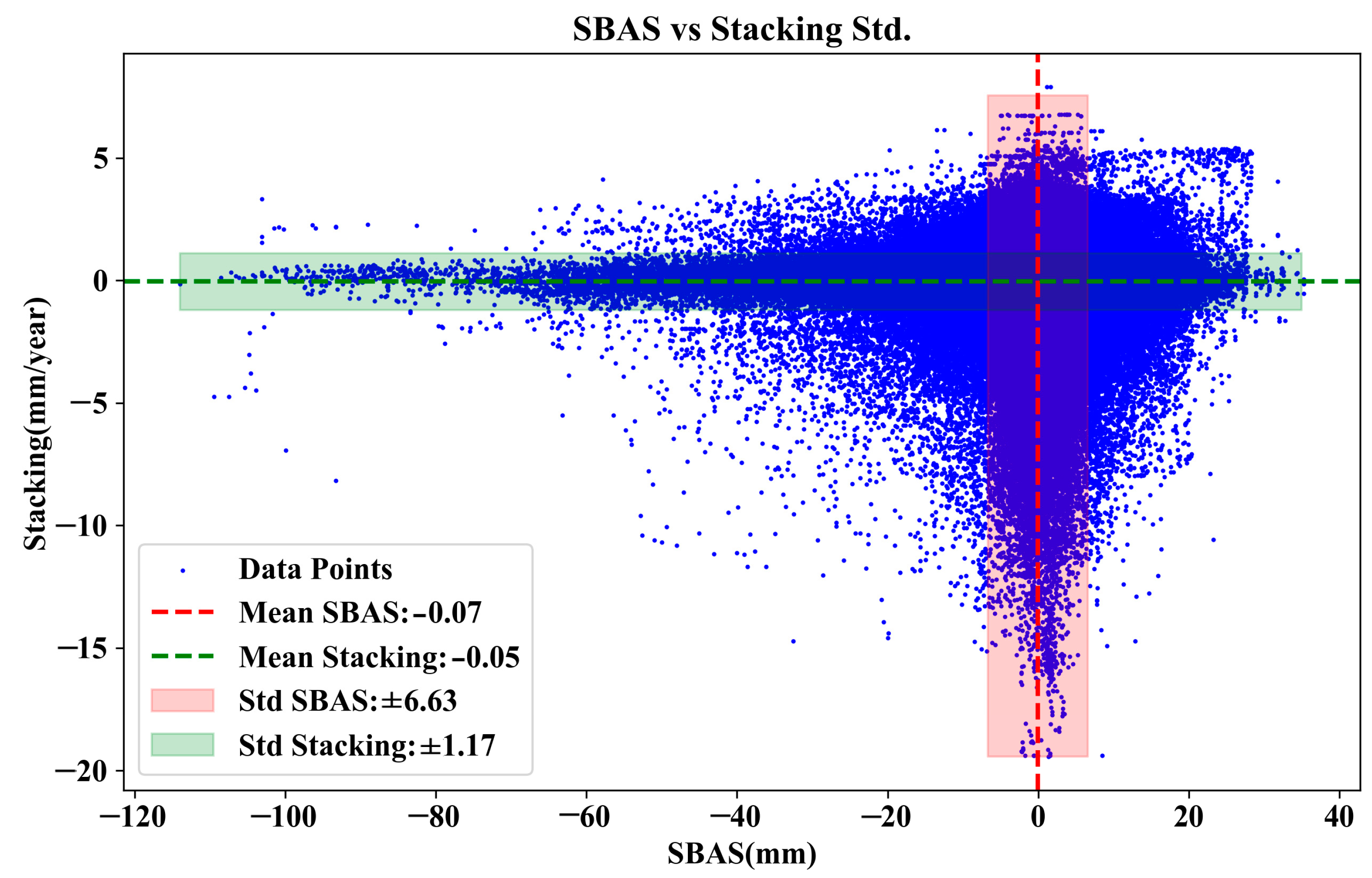
4.1. SBAS- and Stacking-InSAR
4.2. Subsidence and Topographic Elements
4.3. Subsidence and Mining Activities
5. Conclusions
Author Contributions
Funding
Data Availability Statement
Acknowledgments
Conflicts of Interest
References
- Raspini, F.; Bianchini, S.; Moretti, S.; Loupasakis, C.; Rozos, D.; Duro, J.; Garcia, M. Advanced interpretation of interferometric SAR data to detect, monitor and model ground subsidence: Outcomes from the ESA-GMES Terrafirma project. Nat. Hazards 2016, 83, 155–181. [Google Scholar] [CrossRef]
- Zhang, Y.; Liu, Y.; Jin, M.; Jing, Y.; Liu, Y.; Liu, Y.; Sun, W.; Wei, J.; Chen, Y. Monitoring land subsidence in Wuhan city (China) using the SBAS-InSAR method with radarsat-2 imagery data. Sensors 2019, 19, 743. [Google Scholar] [CrossRef] [PubMed]
- Li, D.; Li, B.; Zhang, Y.; Fan, C.; Xu, H.; Hou, X. Spatial and temporal characteristics analysis for land subsidence in Shanghai coastal reclamation area using PS-InSAR method. Front. Mar. Sci. 2022, 9, 1000523. [Google Scholar] [CrossRef]
- Zhang, Z.; Hu, C.; Wu, Z.; Zhang, Z.; Yang, S.; Yang, W. Monitoring and analysis of ground subsidence in Shanghai based on PS-InSAR and SBAS-InSAR technologies. Sci. Rep. 2023, 13, 8031. [Google Scholar] [CrossRef]
- Wang, F.; Tao, Q.; Liu, G.; Chen, Y.; Han, Y.; Guo, Z.; Liu, X. Monitoring of surface deformation in mining area integrating SBAS InSAR and Logistic Function. Environ. Monit. Assess. 2023, 195, 1493. [Google Scholar] [CrossRef] [PubMed]
- Liu, X.; Xing, X.; Wen, D.; Chen, L.; Yuan, Z.; Liu, B.; Tan, J. Mining-induced time-series deformation investigation based on SBAS-InSAR technique: A case study of drilling water solution rock salt mine. Sensors 2019, 19, 5511. [Google Scholar] [CrossRef]
- Fielding, E.J.; Blom, R.G.; Goldstein, R.M. Rapid subsidence over oil fields measured by SAR interferometry. Geophys. Res. Lett. 1998, 25, 3215–3218. [Google Scholar] [CrossRef]
- Gabriel, A.K.; Goldstein, R.M.; Zebker, H.A. Mapping small elevation changes over large areas: Differential radar interferometry. J. Geophys. Res. Solid Earth 1989, 94, 9183–9191. [Google Scholar] [CrossRef]
- Zebker, H.A.; Villasenor, J. Decorrelation in interferometric radar echoes. IEEE Trans. Geosci. Remote Sens. 1992, 30, 950–959. [Google Scholar] [CrossRef]
- Hanssen, R.F. Radar Interferometry: Data Interpretation and Error Analysis; Springer Science & Business Media: Dordrecht, The Netherlands, 2001; Volume 2. [Google Scholar]
- Ferretti, A.; Prati, C.; Rocca, F. Nonlinear subsidence rate estimation using permanent scatterers in differential SAR interferometry. IEEE Trans. Geosci. Remote Sens. 2000, 38, 2202–2212. [Google Scholar] [CrossRef]
- Ferretti, A.; Prati, C.; Rocca, F. Permanent scatterers in SAR interferometry. IEEE Trans. Geosci. Remote Sens. 2001, 39, 8–20. [Google Scholar] [CrossRef]
- Usai, S. A New Approach for Longterm Monitoring of Deformations by Differential SAR Interferometry. Ph.D. Thesis, Delft University of Technology, Delft, The Netherlands, 2001. [Google Scholar]
- Chen, X.; Tessari, G.; Fabris, M.; Achilli, V.; Floris, M. Comparison between PS and SBAS InSAR techniques in monitoring shallow landslides. In Understanding and Reducing Landslide Disaster Risk: Volume 3 Monitoring and Early Warning, 5th ed.; Springer: Cham, Switzerland, 2021; pp. 155–161. [Google Scholar]
- Zhang, P.; Qian, X.; Guo, S.; Wang, B.; Xia, J.; Zheng, X. A New Method for Continuous Track Monitoring in Regions of Differential Land Subsidence Rate Using the Integration of PS-InSAR and SBAS-InSAR. Remote Sens. 2023, 15, 3298. [Google Scholar] [CrossRef]
- Casu, F.; Manzo, M.; Lanari, R. A quantitative assessment of the SBAS algorithm performance for surface deformation retrieval from DInSAR data. Remote Sens. Environ. 2006, 102, 195–210. [Google Scholar] [CrossRef]
- Hu, B.; Wang, H.-S.; Sun, Y.-L.; Hou, J.-G.; Liang, J. Long-term land subsidence monitoring of Beijing (China) using the small baseline subset (SBAS) technique. Remote Sens. 2014, 6, 3648–3661. [Google Scholar] [CrossRef]
- Loesch, E.; Sagan, V. SBAS analysis of induced ground surface deformation from wastewater injection in East Central Oklahoma, USA. Remote Sens. 2018, 10, 283. [Google Scholar] [CrossRef]
- Wu, Q.; Jia, C.; Chen, S.; Li, H. SBAS-InSAR based deformation detection of urban land, created from mega-scale mountain excavating and valley filling in the Loess Plateau: The case study of Yan’an City. Remote Sens. 2019, 11, 1673. [Google Scholar] [CrossRef]
- Zhao, F.; Meng, X.; Zhang, Y.; Chen, G.; Su, X.; Yue, D. Landslide susceptibility mapping of karakorum highway combined with the application of SBAS-InSAR technology. Sensors 2019, 19, 2685. [Google Scholar] [CrossRef] [PubMed]
- Su, X.; Zhang, Y.; Meng, X.; Rehman, M.U.; Khalid, Z.; Yue, D. Updating inventory, deformation, and development characteristics of landslides in Hunza Valley, NW Karakoram, Pakistan by SBAS-InSAR. Remote Sens. 2022, 14, 4907. [Google Scholar] [CrossRef]
- Milczarek, W. Investigation of post inducted seismic deformation of the 2016 Mw4. 2 tarnowek Poland mining tremor based on Dinsar and SBAS methods. Acta Geodyn. Geomat. 2019, 16, 194. [Google Scholar]
- Parwata, I.N.S.; Nakashima, S.; Shimizu, N. Monitoring volcanic activity of Mount Agung, Indonesia by SBAS-DInSAR using Sentinel-1 data from 2014 to 2020. In Rock Mechanics and Engineering Geology in Volcanic Fields; CRC Press: Boca Raton, FL, USA, 2022; pp. 50–57. [Google Scholar]
- Chen, Y.; Tong, Y.; Tan, K. Coal mining deformation monitoring using SBAS-InSAR and offset tracking: A case study of Yu County, China. IEEE J. Sel. Top. Appl. Earth Obs. Remote Sens. 2020, 13, 6077–6087. [Google Scholar] [CrossRef]
- Du, Q.; Li, G.; Chen, D.; Zhou, Y.; Qi, S.; Wu, G.; Chai, M.; Tang, L.; Jia, H.; Peng, W. SBAS-InSAR-Based analysis of surface deformation in the eastern tianshan mountains, China. Front. Earth Sci. 2021, 9, 729454. [Google Scholar] [CrossRef]
- Dai, K.; Liu, G.; Li, Z.; Ma, D.; Wang, X.; Zhang, B.; Tang, J.; Li, G. Monitoring highway stability in permafrost regions with X-band temporary scatterers stacking InSAR. Sensors 2018, 18, 1876. [Google Scholar] [CrossRef] [PubMed]
- Sandwell, D.T.; Price, E.J. Phase gradient approach to stacking interferograms. J. Geophys. Res. Solid Earth 1998, 103, 30183–30204. [Google Scholar] [CrossRef]
- Strozzi, T.; Wegmuller, U.; Werner, C.; Wiesmann, A. Measurement of slow uniform surface displacement with mm/year accuracy. In Proceedings of the IGARSS 2000—IEEE 2000 International Geoscience and Remote Sensing Symposium—Taking the Pulse of the Planet: The Role of Remote Sensing in Managing the Environment, Proceedings (Cat. No. 00CH37120), Honolulu, HI, USA, 24–28 July 2000; pp. 2239–2241. [Google Scholar]
- Zhao, Q.; Lin, H.; Jiang, L. Ground deformation monitoring in Pearl River Delta region with Stacking D-InSAR technique. In Proceedings of the Geoinformatics 2008 and Joint Conference on GIS and Built Environment: Monitoring and Assessment of Natural Resources and Environments, Guangzhou, China, 3 November 2008; pp. 366–374. [Google Scholar]
- Qin, Z.; Agarwal, V.; Gee, D.; Marsh, S.; Grebby, S.; Chen, Y.; Meng, N. Study of ground movement in a mining area with geological faults using FDM analysis and a stacking InSAR method. Front. Environ. Sci. 2021, 9, 787053. [Google Scholar] [CrossRef]
- Jiang, L.; Lin, H.; Ma, J.; Kong, B.; Wang, Y. Potential of small-baseline SAR interferometry for monitoring land subsidence related to underground coal fires: Wuda (Northern China) case study. Remote Sens. Environ. 2011, 115, 257–268. [Google Scholar] [CrossRef]
- Zhu, Y.; Yao, X.; Yao, L.; Yao, C. Detection and characterization of active landslides with multisource SAR data and remote sensing in western Guizhou, China. Nat. Hazards 2022, 111, 973–994. [Google Scholar] [CrossRef]
- Maaß, A.-L.; Schüttrumpf, H. Long-term effects of mining-induced subsidence on the trapping efficiency of floodplains. Anthropocene 2018, 24, 1–13. [Google Scholar] [CrossRef]
- Bazaluk, O.; Kuchyn, O.; Saik, P.; Soltabayeva, S.; Brui, H.; Lozynskyi, V.; Cherniaiev, O. Impact of ground surface subsidence caused by underground coal mining on natural gas pipeline. Sci. Rep. 2023, 13, 19327. [Google Scholar] [CrossRef] [PubMed]
- Shahani, N.; Wan, Z.; Ali, M.; Ullah, B. Detection and monitoring of underground coal mine gases at Lakhra Coal Mines, Pakistan. In Proceedings of the 35th Annual International Pittsburgh Conference, Xuzhou, China, 15–18 October 2018; pp. 1–8. [Google Scholar]
- Sanjrani, M.; Memon, I.; Awan, B. Environmental Impact of Lakhra Coal Mining, Sindh province, Pakistan. N. Am. Acad. Res. 2018, 1, 72–75. [Google Scholar]
- Guo, J.; Hu, J.; Li, B.; Zhou, L.; Wang, W. Land subsidence in Tianjin for 2015 to 2016 revealed by the analysis of Sentinel-1A with SBAS-InSAR. J. Appl. Remote Sens. 2017, 11, 026024. [Google Scholar] [CrossRef]
- Ferretti, A.; Monti-Guarnieri, A.; Prati, C.; Rocca, F.; Massonet, D. SAR Principles-Guidelines for SAR Interferometry Processing and Interpretation; European Space Agency: Paris, France, 2007; Volume 19. [Google Scholar]
- Berardino, P.; Fornaro, G.; Lanari, R.; Sansosti, E. A new algorithm for surface deformation monitoring based on small baseline differential SAR interferograms. IEEE Trans. Geosci. Remote Sens. 2002, 40, 2375–2383. [Google Scholar] [CrossRef]
- Schmidt, D.A.; Bürgmann, R. Time-dependent land uplift and subsidence in the Santa Clara valley, California, from a large interferometric synthetic aperture radar data set. J. Geophys. Res. Solid Earth 2003, 108. [Google Scholar] [CrossRef]
- Lanari, R.; Mora, O.; Manunta, M.; Mallorquí, J.J.; Berardino, P.; Sansosti, E. A small-baseline approach for investigating deformations on full-resolution differential SAR interferograms. IEEE Trans. Geosci. Remote Sens. 2004, 42, 1377–1386. [Google Scholar] [CrossRef]
- Hooper, A. A multi-temporal InSAR method incorporating both persistent scatterer and small baseline approaches. Geophys. Res. Lett. 2008, 35. [Google Scholar] [CrossRef]
- Yan, Y.; Doin, M.-P.; Lopez-Quiroz, P.; Tupin, F.; Fruneau, B.; Pinel, V.; Trouvé, E. Mexico City subsidence measured by InSAR time series: Joint analysis using PS and SBAS approaches. IEEE J. Sel. Top. Appl. Earth Obs. Remote Sens. 2012, 5, 1312–1326. [Google Scholar] [CrossRef]
- Hu, J.; Li, Z.; Zhu, J.; Liu, J. Theory and Application of Monitoring 3-D Deformation with InSAR; Science Press: Beijing, China, 2021; ISBN 978-7-03-068643-5. [Google Scholar]
- Wegnüller, U.; Werner, C.; Strozzi, T.; Wiesmann, A.; Frey, O.; Santoro, M. Sentinel-1 support in the GAMMA software. Procedia Comput. Sci. 2016, 100, 1305–1312. [Google Scholar] [CrossRef]
- Huang, G.; Dong, J.; Xi, W.; Zhao, Z.; Li, S.; Kuang, Z.; An, Q.; Wei, J.; Zhu, Y. Study on surface deformation pattern in mine closure area of complex karst mountainous region based on SBAS-InSAR technology. Front. Earth Sci. 2024, 11, 1353593. [Google Scholar] [CrossRef]
- Xu, Y.; Li, T.; Tang, X.; Zhang, X.; Fan, H.; Wang, Y. Research on the applicability of DInSAR, stacking-InSAR and SBAS-InSAR for mining region subsidence detection in the datong coalfield. Remote Sens. 2022, 14, 3314. [Google Scholar] [CrossRef]
- Guo, N.; Zhan, W. Research on the method of three-dimensional surface displacements of Tianjin area based on combined multi-source measurements. J. Appl. Geod. 2020, 14, 83–94. [Google Scholar] [CrossRef]
- Jianjun, Z.; Zefa, Y.; Zhiwei, L. Recent progress in retrieving and predicting mining-induced 3D displace-ments using InSAR. Acta Geod. Cartogr. Sin. 2019, 48, 135. [Google Scholar]
- Wang, H.; Zeng, Q.; Jiao, J.; Chen, J. InSAR Time Series Analysis Technique Combined with Sequential Adjustment Method for Monitoring of Surface Deformation. Beijing Da Xue Xue Bao 2021, 57, 241–249. [Google Scholar]
- Gong, W.; Thiele, A.; Hinz, S.; Meyer, F.J.; Hooper, A.; Agram, P.S. Comparison of small baseline interferometric SAR processors for estimating ground deformation. Remote Sens. 2016, 8, 330. [Google Scholar] [CrossRef]
- Li, Z.; Tian, Z.; Wang, B.; Li, W.; Chen, Q.; Zhang, Z. Monitoring and Assessment of SBAS-InSAR Deformation for Sustainable Development of Closed Mining Areas—A Case of Nanzhuang Mining Area. IEEE Access 2023, 11, 22935–22947. [Google Scholar] [CrossRef]
- Chen, D.; Chen, H.; Zhang, W.; Cao, C.; Zhu, K.; Yuan, X.; Du, Y. Characteristics of the residual surface deformation of multiple abandoned mined-out areas based on a field investigation and SBAS-InSAR: A case study in Jilin, China. Remote Sens. 2020, 12, 3752. [Google Scholar] [CrossRef]
- Eker, R.; Aydın, A.; Görüm, T. Tracking deformation velocity via PSI and SBAS as a sign of landslide failure: An open-pit mine-induced landslide in Himmetoğlu (Bolu, NW Turkey). Nat. Hazards 2024, 120, 7701–7724. [Google Scholar] [CrossRef]
- Vervoort, A. Uplift of the surface of the earth above abandoned coal mines. Part B: Framework to understand and explain uplift. Int. J. Rock Mech. Min. Sci. 2021, 148, 104947. [Google Scholar] [CrossRef]
- Vervoort, A. Uplift of the surface of the earth above abandoned coal mines. Part A: Analysis of satellite data related to the movement of the surface. Int. J. Rock Mech. Min. Sci. 2021, 148, 104896. [Google Scholar] [CrossRef]
- Zheng, L.; Zhu, L.; Wang, W.; Guo, L.; Chen, B. Land subsidence related to coal mining in China revealed by L-band InSAR analysis. Int. J. Environ. Res. Public Health 2020, 17, 1170. [Google Scholar] [CrossRef] [PubMed]
- Fan, H.; Wang, L.; Wen, B.; Du, S. A new model for three-dimensional deformation extraction with single-track InSAR based on mining subsidence characteristics. Int. J. Appl. Earth Obs. Geoinf. 2021, 94, 102223. [Google Scholar] [CrossRef]
- Chen, F.; Lin, H.; Zhou, W.; Hong, T.; Wang, G. Surface deformation detected by ALOS PALSAR small baseline SAR interferometry over permafrost environment of Beiluhe section, Tibet Plateau, China. Remote Sens. Environ. 2013, 138, 10–18. [Google Scholar] [CrossRef]
- Ge, W.; Li, Y.; Wang, Z.; Zhang, C.; Yang, H. Spatial-Temporal Ground Deformation Study of Baotou Based on the PS-InSAR Method. Acta Geol. Sin.-Engl. Ed. 2021, 95, 674–683. [Google Scholar] [CrossRef]


| Land Type | Mean | Median | Stdev | Minimum | Maximum | Minority | Majority |
|---|---|---|---|---|---|---|---|
| Bare ground | 1.11 | 1.19 | 5.53 | −80.46 | 28.93 | −80.46 | −1.37 |
| Rangeland | −0.06 | 0.48 | 6.99 | −114.02 | 37.39 | −114.02 | −43.02 |
| Crop | −5.83 | −2.67 | 11.68 | −55.68 | 17.53 | −43.65 | −39.54 |
| Land Type | Mean | Median | Stdev | Minimum | Maximum | Minority | Majority |
|---|---|---|---|---|---|---|---|
| Bare ground | 0.36 | 0.40 | 0.95 | −14 | 5.34 | −14 | 0 |
| Rangeland | 0.16 | 0.25 | 1.20 | −19 | 6.8 | −19 | −5.10 |
| Crop | −1.04 | −0.40 | 2.05 | −7.28 | 2.71 | −6.44 | −7.28 |
Disclaimer/Publisher’s Note: The statements, opinions and data contained in all publications are solely those of the individual author(s) and contributor(s) and not of MDPI and/or the editor(s). MDPI and/or the editor(s) disclaim responsibility for any injury to people or property resulting from any ideas, methods, instructions or products referred to in the content. |
© 2024 by the authors. Licensee MDPI, Basel, Switzerland. This article is an open access article distributed under the terms and conditions of the Creative Commons Attribution (CC BY) license (https://creativecommons.org/licenses/by/4.0/).
Share and Cite
Ashraf, T.; Yin, F.; Liu, L.; Zhang, Q. Land Subsidence Detection Using SBAS- and Stacking-InSAR with Zonal Statistics and Topographic Correlations in Lakhra Coal Mines, Pakistan. Remote Sens. 2024, 16, 3815. https://doi.org/10.3390/rs16203815
Ashraf T, Yin F, Liu L, Zhang Q. Land Subsidence Detection Using SBAS- and Stacking-InSAR with Zonal Statistics and Topographic Correlations in Lakhra Coal Mines, Pakistan. Remote Sensing. 2024; 16(20):3815. https://doi.org/10.3390/rs16203815
Chicago/Turabian StyleAshraf, Tariq, Fang Yin, Lei Liu, and Qunjia Zhang. 2024. "Land Subsidence Detection Using SBAS- and Stacking-InSAR with Zonal Statistics and Topographic Correlations in Lakhra Coal Mines, Pakistan" Remote Sensing 16, no. 20: 3815. https://doi.org/10.3390/rs16203815
APA StyleAshraf, T., Yin, F., Liu, L., & Zhang, Q. (2024). Land Subsidence Detection Using SBAS- and Stacking-InSAR with Zonal Statistics and Topographic Correlations in Lakhra Coal Mines, Pakistan. Remote Sensing, 16(20), 3815. https://doi.org/10.3390/rs16203815