Article

Assessing Evapotranspiration Changes in Response to Cropland Expansion in Tropical Climates

by
Leonardo Laipelt
1,*,
Julia Brusso Rossi
1,
Bruno Comini de Andrade
1,
Morris Scherer-Warren
2 and
Anderson Ruhoff
1
1
Instituto de Pesquisas Hidráulicas, Universidade Federal do Rio Grande do Sul, Porto Alegre 91501-970, RS, Brazil
2
Agência Nacional de Águas e Saneamento Básico (ANA), Brasília 70610-200, DF, Brazil
*
Author to whom correspondence should be addressed.
Remote Sens. 2024, 16(18), 3404; https://doi.org/10.3390/rs16183404
Submission received: 14 July 2024 / Revised: 3 September 2024 / Accepted: 10 September 2024 / Published: 13 September 2024

Abstract

:
The expansion of cropland in tropical regions has significantly accelerated in recent decades, triggering an escalation in water demand and changing the total water loss to the atmosphere (evapotranspiration). Additionally, the increase in areas dedicated to agriculture in tropical climates coincides with an increased frequency of drought events, leading to a series of conflicts among water users. However, detailed studies on the impacts of changes in water use due to agriculture expansion, including irrigation, are still lacking. Furthermore, the higher presence of clouds in tropical environments poses challenges for the availability of high-resolution data for vegetation monitoring via satellite images. This study aims to analyze 37 years of agricultural expansion using the Landsat collection and a satellite-based model (geeSEBAL) to assess changes in evapotranspiration resulting from cropland expansion in tropical climates, focusing on the São Marcos River Basin in Brazil. It also used a methodology for estimating daily evapotranspiration on days without satellite images. The results showed a 34% increase in evapotranspiration from rainfed areas, mainly driven by soybean cultivation. In addition, irrigated areas increased their water use, despite not significantly changing water use at the basin scale. Conversely, natural vegetation areas decreased their evapotranspiration rates by 22%, suggesting possible further implications with advancing changes in land use and land cover. Thus, this study underscores the importance of using satellite-based evapotranspiration estimates to enhance our understanding of water use across different land use types and scales, thereby improving water management strategies on a large scale.

1. Introduction

Agriculture stands as the largest consumer of freshwater resources on a global scale [1]. The increasing withdrawal of water for food production, in response to the demands of population growth, has shown potential consequences at both field and basin scales, as it may reduce the water availability for other purposes, contributing to water scarcity [2,3]. Beyond agriculture expansion, irrigation has been used as an alternative to mitigate the risks associated with crop production, as it can enhance crop yields [4] and potentially reduce costs [5]. Such benefits of using irrigation systems are partially responsible for the notable escalation in water withdrawals over recent decades. Advancements in technology are needed to enhance water management strategies, aiming to embrace more sustainable practices [6,7]. However, providing accurate and long-term data on water loss to the atmosphere at the field scale poses challenges, as crop growth involves several physical and phenological phenomena.
Evapotranspiration (ET) can be used as a proxy for crop water use over rainfed and irrigated lands [8,9], as well as across different land types. ET is an essential component of the water cycle and surface energy budget, representing the sum of soil/interception evaporation and plant transpiration. Several studies have demonstrated that ET is a key driver for agriculture, being used as an indicator of water stress conditions [9], as well as to define the crop coefficient (Kc) (ratio of the crop evapotranspiration to the reference evapotranspiration) [10], and to manage water irrigation [11,12,13]. On the other hand, ET observations are not commonly available data, since it requires onerous instruments and intensive maintenance compared to other hydrometeorological instruments [14], with the added limitation that their spatial representation is confined to the conditions surrounding the instrument. Consequently, alternatives have been tested to obtain ET estimation at the daily scale, combining meteorological and surface data with physical and empirical approaches.
Among the available options, satellite images have been widely used globally to estimate spatial and temporal changes in ET due to water use in agriculture [8,15,16,17]. Remote sensing-based models combined meteorological and satellite data to estimate ET based on phenological (vegetation index-based) or energy balance (surface temperature-based) approaches. In particular, surface energy balance (SEB) models are highly indicated for monitoring agriculture, as the surface temperature serves as a key proxy of vegetation water status [9]. Regarding its accuracy, studies have demonstrated that SEB models show good correlation with observed data, even across different biomes in tropical environments [18,19,20]. Errors in SEB models are typically in the range of 1.0–1.2 mm day−1 for tropical areas [20,21,22,23], which is consistent with global expectations for SEB accuracy [17].
For irrigation monitoring, ET information of high temporal and spatial resolution is essential to estimate the required water to manage crop growth. Due to the spatial/temporal resolution tradeoffs, high-resolution satellites often cover small areas, and thus have longer revisit time (10–20 days). Additionally, multispectral and thermal satellite sensors are directly influenced by the cloud cover, which can increase the temporal gap between two clear sky images for the same location. Therefore, different alternatives have been adopted to improve temporal coverage in SEB models [24,25,26]. Singh et al. [24] combined Landsat and Sentinel data to improve temporal coverage based on the relationship between the ratio of ET fraction and Normalized Difference Vegetation Index (NDVI). Similar, Anderson et al. [25] used the Atmosphere–Land Exchange Inverse (ALEXI) and tested the efficacy of a simple gap-filling algorithm, assuming that the ratio of ET to reference ET between clear sky Landsat overpass dates is conserved, showing the potential to use simple methods to improve ET daily coverage from SEB models.
Thus, in this study, we used a remote sensing-based ET model to investigate the impact of cropland expansion on water use under tropical climate conditions for a 37-year period. We selected a hotspot of cropland expansion in Brazil as a study case, with a history of water scarcity conflicts and intense irrigation expansion. Our specific questions are as follows. (i) What were the changes in ET due to land use and cover changes? (ii) How has the increase in irrigated cropland impacted water use? (iii) How significantly does ET increase in irrigated cropland areas compared to rainfed croplands at a daily scale using a gap-filling approach between overpass scenes?

2. Materials and Methods

2.1. Study Area

The study area is located in a hotspot of irrigation expansion in Brazil, the São Marcos River Basin, between the states of Goiás and Minas Gerais (Figure 1). This river basin has the highest concentration of pivot irrigation system in Brazil. The river is a major tributary of the Parnaiba River, and part of the Paraná basin. The São Marcos River Basin has an area of 12,200 km2, of which around 9% is irrigated by the center pivot method (2022). According to Köppen–Geiger classification [27], the study area is mostly classified as tropical zones with a dry winter (Aw), with average temperatures between 18 °C and 28 °C, and long-term average precipitation around 1600 mm year−1.
Irrigation has been adopted in the basin since the 1980s, driven by fiscal policies and government incentives aimed at expanding agriculture across the Cerrado biome. With the significant increase in irrigated area, conflicts have emerged recently due to excessive withdrawals for irrigated agriculture, reducing water availability and impacting hydropower reservoirs located downstream in the basin.

2.2. geeSEBAL

We used the Google Earth Engine (GEE) surface energy balance model algorithm for land (geeSEBAL), developed and validated for the location by Laipelt et al. [20] to estimate daily ET over the study area. The geeSEBAL is based on the Surface Energy Balance Algorithm for Land (SEBAL) [28,29], which has been globally validated across irrigated croplands [30,31].
To estimate ET, geeSEBAL used the energy balance equation (Equation (1)) to estimate the instantaneous energy fluxes, obtaining the latent heat flux (LE) as the residual of the equation:
L E = R n H G
where R n is the net radiation flux (Equation (2)), G is the soil heat flux (Equation (3)), and H is the sensible heat flux (Equation (4)).
R n = 1 α R s d o w n + R l d o w n R l u p 1 ε 0 R l d o w n
where α is the surface albedo, estimated according to Tasumi et al. [32]. R s d o w n and R l d o w n are the shortwave and longwave incoming radiation, respectively; R l u p is the longwave outgoing radiation; ε 0 is the surface thermal emissivity.
G = α T s 273.15 0.0038 α + 0.0074 α 2 ( 1 0.98 N D V I 4 )
where T s is the land surface temperature.
H = ρ a C p d T r a h
where ρ a is the air density, C p is the specific heat capacity, d T is the gradient temperature difference, r a h is the aerodynamic resistance to turbulent heat transport.
As in Equation (4), both H and r a h are unknown; the model uses an automatic internal calibration to obtain both pieces of information based on an iteration process. The process involves the select of two extreme conditions of temperature and humidity, also known as the hot and cold pixels, to represent a linear relationship between the T s and d T . Thus, it assumes that H is zero in an extreme wet condition, as all the available energy is converted into L E , which is the inverse for an extreme hot condition ( L E = 0; H = max.). During the iterative process, conditions of atmospheric stability are corrected based on the Monin–Obukhov similarity, converging to the final estimative of r a h .
The last step is computing the evaporative fraction ( E F ) (Equation (5)) to upscale the instantaneous L E to actual E T , by multiplying E F by the reference ET ( E T r ) (Equation (6)).
E F = L E R n G
E T = E F E T r
The E T r is the evapotranspiration rate from a reference surface (hypothetical grass crop with specific characteristics) without water limitation, derived from the FAO56 proposed method (based on the original Penman–Monteith equation) [33]. More details of the model can be found in Laipelt et al. [20] and Bastiaanssen et al. [28].

2.3. Land Use and Land Cover Classification

We used the annual land use and land cover classification from MapBiomas [34] version 8.0 to assess the spatial and temporal variation between different land cover conditions located in the study area. The classification is available in the GEE platform [35] at high resolution (30 m) based on different satellite datasets (Landsat, Sentinel, Planet).

2.4. Pivot-Irrigated Mapping

To identify irrigation areas over the study area, we used different datasets of annual classification produced by the Brazilian Water and Sanitation Agency (ANA) for the study area (https://metadados.snirh.gov.br/, accessed on 10 April 2024). The classification only identified irrigation by the center pivot method, which is the main technique used in Brazil, especially under a tropical climate. Due to this limitation, we assumed in the study that irrigation has been used only in areas with center pivots.

2.5. Data Processing

We used surface reflectance and thermal images from Landsat collection 2, which provides homogenized images with consistent geometry, radiometric, and atmospheric calibrations. Collection 2 includes data from Landsat 5 TM (1984 to 2011), Landsat 7 ETM (1999 to present), Landsat 8 OLI/TIRS (2013 to present), and Landsat 9 OLI2/TIRS2 (2022 to present) to estimate daily E T between 1986 and 2022 over the study area. We removed clouds and shadows using the quality control mask available for each scene, considering only images with less than 40% of cloud cover (71% of the total available images) to avoid potential biases from cloud classification errors and atmospheric water contamination. As meteorological inputs, we used information from the ERA5 Land at hourly and daily temporal resolution, including incoming solar radiation ( R s ), air temperature ( T a i r ), relative humidity (RH), and wind speed ( w s ).

2.6. Gap Filling

To obtain daily E T estimate for days with unavailable satellite imagery due to temporal resolution or extensive cloud cover, we applied a linear interpolation between E F estimates from two near clear-sky images. Subsequently, we estimated the E T for the given date by multiplying the interpolated E F by the corresponding E T r , as shown in Equations (7) and (8):
E F i n t e r p n = ( E F k + 1 E F k ) ( n k ) k + 1 k + E F k
where E F i n t e r p n   is the interpolated E F for a specific ( n ) date; E F k + 1 is the E F for the next available Landsat scene ( k + 1 ); and E F k is the E F for the previous scene ( k ).
E T n = E F i n t e r p n E T r n
where E T n   and E T r n are the daily and reference E T for a specific ( n ) date, respectively.
Then, we used Equation (9) to obtain monthly and annual E T aggregations:
E T p e r i o d = n = 1 m E T n
where E T p e r i o d is the E T for a specific period (monthly/yearly) between an interval of m days.

3. Results

3.1. Seasonal Patterns of Evapotranspiration

We computed the long-term average ET for the different land covers and uses identified in the study area between 1986 and 2022. Overall, we identified seven main land uses located in the Cerrado biome: savanna, forest, forest plantation, grassland, pasture, rainfed agriculture, and irrigated agriculture. Figure 2a illustrates the average ET of each classification, showing that the highest values were observed for areas classified as forest (3.3 ± 0.60 mm day−1), followed by forest plantation (3.1 ± 0.59 mm day−1) and savanna (2.9 ± 0.51 mm day−1). In addition, grassland exhibited values similar to those found for pasture, with average ET of 2.6 ± 0.48 mm day−1 and 2.4 ± 0.49 mm day−1, respectively. Rainfed agriculture showed lower average ET (2.2 ± 0.7 mm day−1) compared to areas classified as irrigated agriculture (2.8 ± 0.54 mm day−1).
The monthly means for each land use are shown in Figure 2b, highlighting the differences across seasons. Forest vegetation exhibited a pronounced seasonality throughout the months (from 77.4 to 114.9 mm month−1), yielding the highest ET results, with similar results for forest plantation (from 73.1 to 109.8 mm month−1) and savanna (from 70.5 to 103.5 mm month−1). In contrast, grassland and pasture exhibited minimal seasonality, maintaining ET values from 65.4 to 91.6 mm month−1 and 61.9 to 89.7 mm month−1, respectively, throughout the year. Rainfed agricultural areas exhibited the lowest ET, showcasing a clear decrease in ET during the dry season, followed by an increase from September to February, coinciding with the beginning of the wet season. On the other hand, irrigated agriculture areas exhibited minimal seasonal variation (from 73.5 to 93.4 mm month−1), with average ET values of 81.2 mm month−1 throughout the year. This suggests that the use of irrigation systems during the dry season is clearly captured by satellite data.
We also found that annual ET variation depended on the land cover and use (Figure 2c). Overall, increasing annual ET was observed for irrigated areas (8.7%; p = 0.1) according to the Mann–Kendall test, followed by savanna (7.1%; p = 0.1) and forest (6.0%; p = 0.1). However, we found a decrease in ET for forest plantation (−11%; p = 0.1) and pasture (−5%; p = 0.1), while we did not identify trends for grassland and rainfed agriculture (p = 0.1).
Changes in ET over the decades due to cropland expansion in the basin can also be associated with variations in ET drivers such as air temperature, vapor pressure deficit (VPD), global radiation, and precipitation (Supplementary Figure S1). During the study period, air temperature increased by 1.2 °C (p = 0.1), with a more pronounced rise during the dry season (1.7 °C; p = 0.1) compared to the wet season (0.5 °C; p = no trend). Similarly, VPD showed positive trends, increasing by 23% during the study period. These changes suggest a correlation with ET changes, as ET has increased in areas such as irrigated fields and natural vegetation (savanna and forest), where a warmer atmosphere can raise water demand in areas not water-limited. On the other hand, changes in precipitation and global radiation have shown no significant trends in the São Marcos River basin, suggesting that they do not have a major influence on ET trends observed in our results.

3.2. Changes in Spatial Patterns and ET

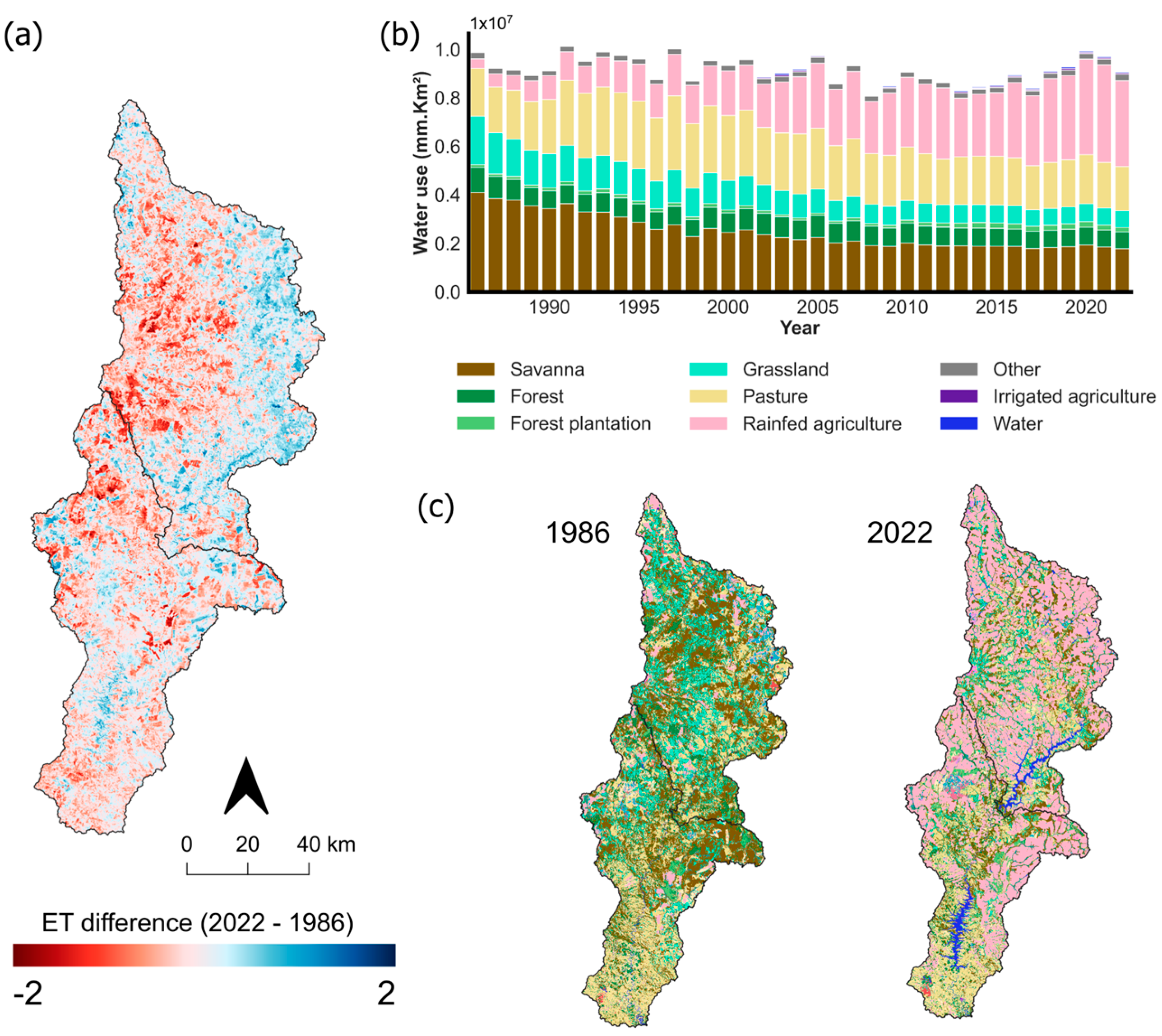
Annual ET from 1986 and 2022 (Figure 3a) showed contrasting spatial patterns across the São Marcos River Basin, with a notable decrease in ET observed in areas classified as savanna and grassland in 1986. Moreover, there was an increase in water use from soybean cultivation (rainfed agriculture), displayed in Figure 3b,c, showing an increase from 4% in 1986 to 38% in 2022. During the same period, water use from pastures first increased from 20% to 30% between 1986 and 1998, and later decreased to 19% in 2022. For natural areas, forests have maintained a contribution between 1 and 2%, while the contribution of savannas has decreased significantly from 41% to 19%. Additionally, irrigated areas have reported an increase in their water use contribution, from 0.02% to 0.55%, as its coverage represented 22% of the total cropland area and only 9% of the total study area in 2022, which is approximately 1132 km2 (Figure 3c). This suggests that despite the extensive utilization of irrigation systems throughout the basin in recent decades, the overall water use contribution remains low compared to other land uses at a large scale.
These findings, especially regarding the contribution of water from rainfed agriculture expansion, indicate that over recent decades, changes in land cover have substantially altered the ET sources within the São Marcos River basin, shifting from forest and grassland areas to agricultural lands dominated by soybean cultivation. This shift in ET sources presents significant differences in both seasonality and magnitude between the natural savanna vegetation and rainfed agriculture (Figure 2b). Such differences may have considerable implications for the regional water balance at a larger scale (see Section 4.1).
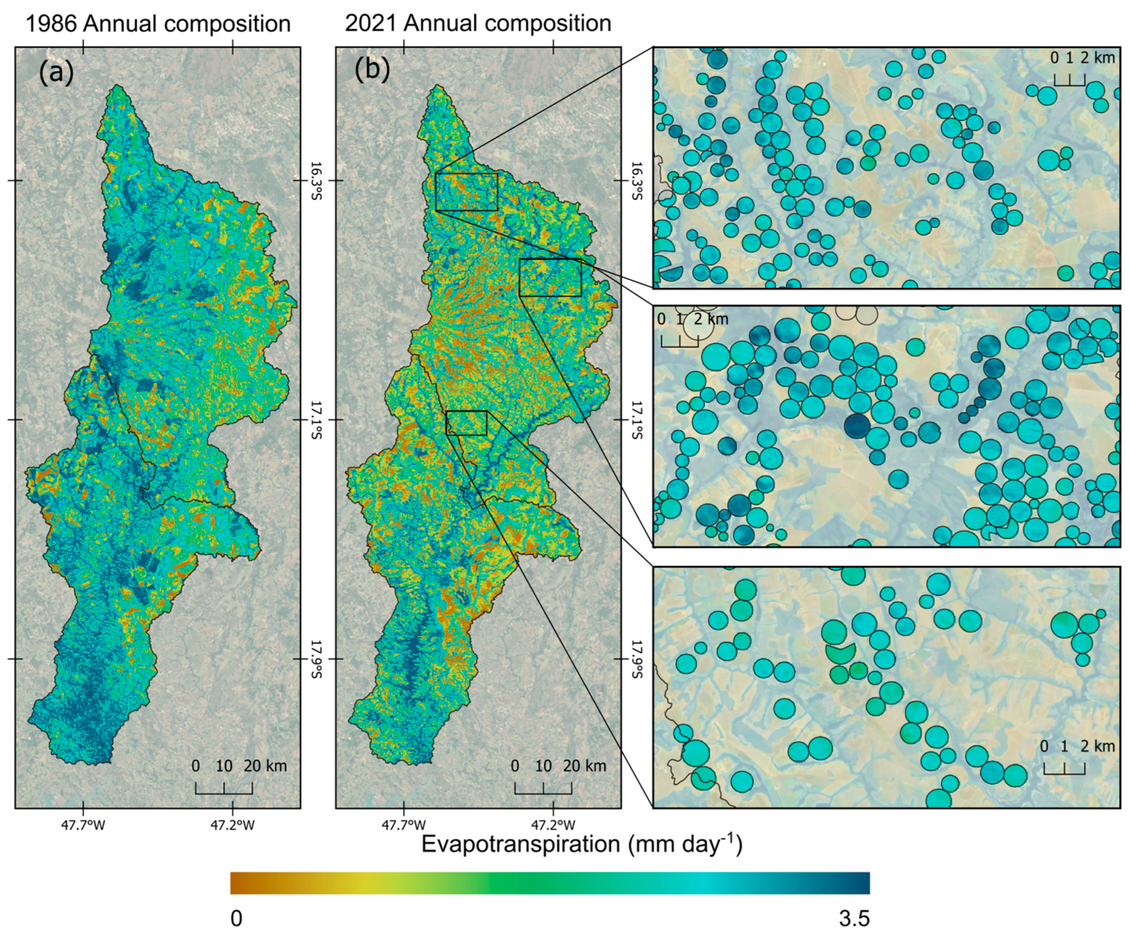
Figure 4 presents a comparison of average ET in the São Marcos River Basin from 1986 to 2021, based on Landsat-derived data. During this period, the number of irrigation pivots surged dramatically from 3 to 1655, with diameters ranging between 400 and 1600 m. This expansion of irrigation infrastructure is accompanied by a significant reduction in savanna areas, as natural vegetation has been largely replaced by rainfed agriculture and irrigated fields. The conversion from savanna to rainfed agriculture resulted in a long-term average decrease in ET of 0.70 mm day−1, while the shift to irrigated agriculture corresponds to a decrease of around 0.1 mm day−1. Overall, despite a −4.5% overall decline in daily ET values across the basin, the Mann–Kendall test did not identify a statistically significant decreasing trend (p = 0.1). This suggests that while land use changes have led to localized reductions in ET, the aggregate trend for the entire basin remains relatively stable.
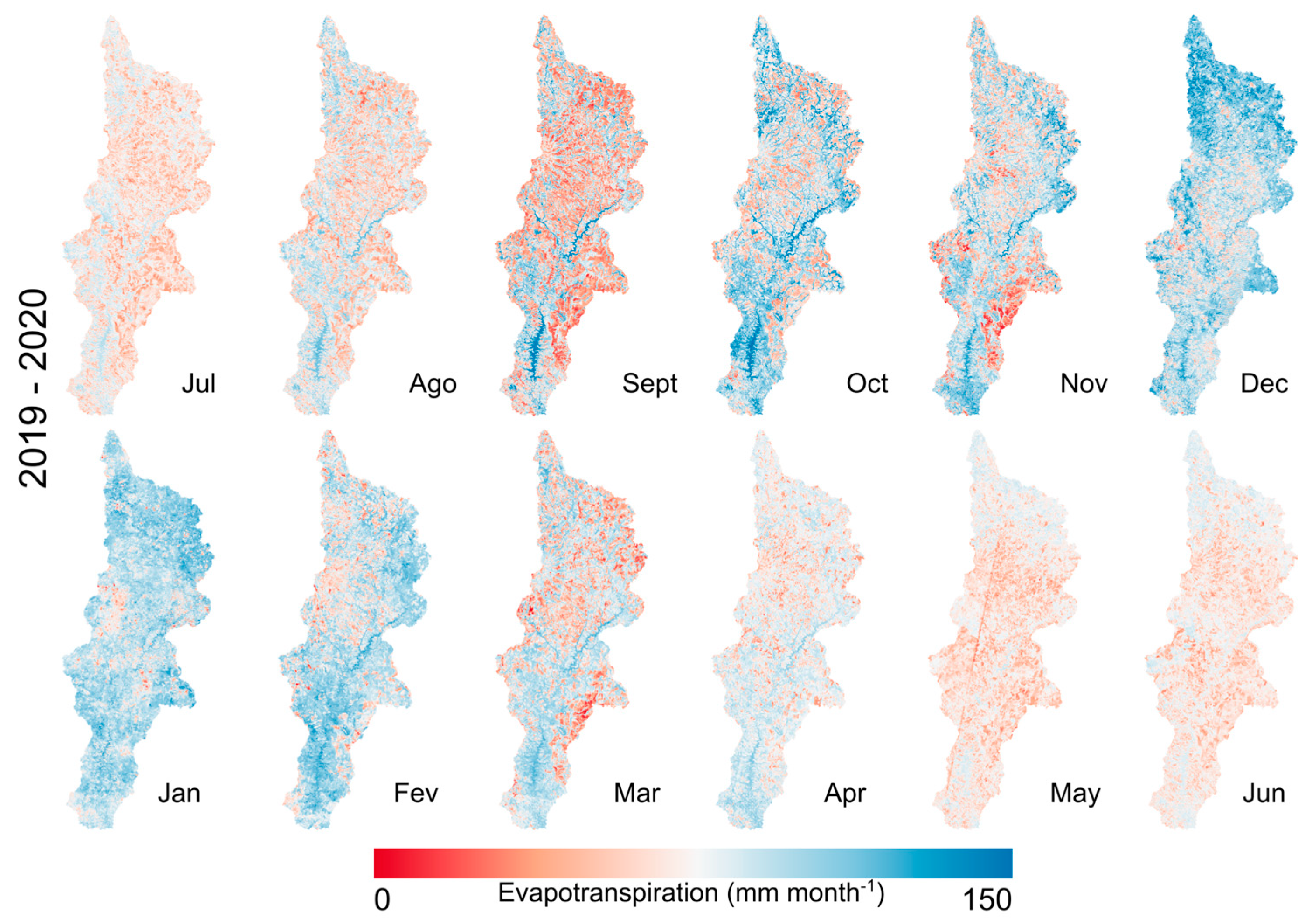
Monthly variations in ET across the São Marcos River Basin are presented in Figure 5. The study area’s ET is constrained by water availability, leading to low ET values (ranging from 65 to 92 mm month−1) during the dry season (May to September), except in water bodies, natural vegetation, and active irrigation systems. This pattern shifts markedly with the onset of the rainy season, where water availability ceases to be a limiting factor, causing a significant increase in ET values. Particularly in December and January, the northern regions of the basin, which are characterized by extensive irrigated and rainfed croplands, exhibit elevated ET values, averaging 90 mm month−1. In contrast, during the transition months between the dry and rainy seasons (October to November), there are noticeable differences in ET between irrigated and rainfed croplands. For instance, in the southeastern region, dominated by rainfed croplands, ET values remain low (averaging 56 mm month−1) due to the lack of rainfall and irrigation. Meanwhile, in irrigated areas in the northern part of the basin, average ET values are notably higher, around 65 mm month−1.

3.3. Difference in Daily Interpolated ET between Irrigated and Rainfed Croplands

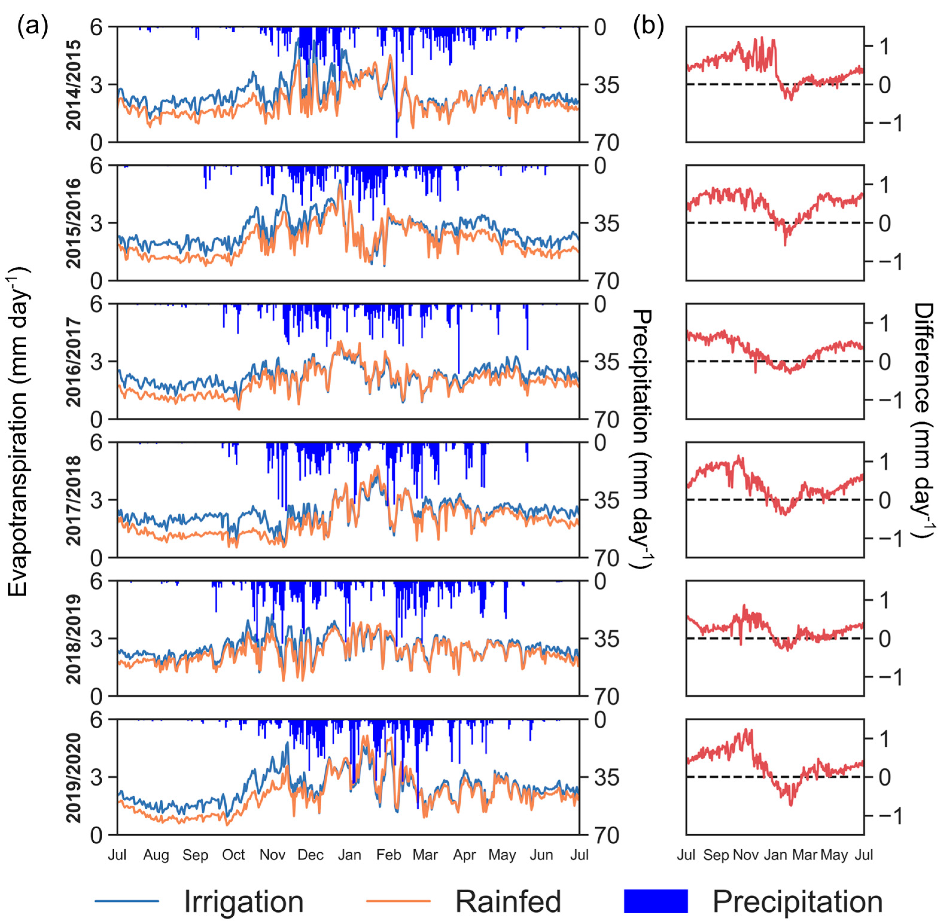
Figure 6 presents the results of the daily ET via experimental interpolation between available Landsat scenes for different hydrological years from 2020 to 2024. Notably, despite using a linear interpolation between Landsat acquisition dates, the ET variability due to precipitation events was effectively preserved by the ETr, maintaining the climatological variation. Additionally, although the methodology may affect sensitivity and the spatial resolution of ET variability across different land uses and cover types, the results still effectively distinguish between ET conditions in irrigated and non-irrigated areas.
The differences between estimated ET for non-irrigated and irrigated agriculture were more pronounced at a daily analysis scale (rather than only when Landsat scenes are available), demonstrating the importance of the proposed methodology. Figure 6a shows that the differences between rainfed and irrigated areas are more significant during the dry season. The largest differences were observed during periods with the lowest precipitation rates (2016/2017), with differences of 0.65 mm day−1, while periods of higher precipitation rates (2017/2018) showed smaller differences, with daily ET differences around 0.36 mm day−1. Additionally, during the growing season, ET rates in irrigated croplands reached 2.4 ± 0.50 mm day−1, whereas in rainfed croplands, maximum values were 1.85 ± 0.64 mm day−1. These differences are evident when comparing the annual ET accumulation and the additional water used by irrigated areas with rainfed agriculture. For the period between 2014 and 2020, the average ET accumulation indicates an increase of 97 to 143 mm, which corresponds to a 12–22% increase in ET compared to rainfed agriculture.

4. Discussion

4.1. Impact of Agriculture Expansion on ET in the São Marcos River Basin

The expansion of agriculture over the São Marcos River Basin in the Cerrado biome has led to significant land use changes. There was a slight decrease in ET in this basin between 1986 and 2022, alongside a loss of native vegetation, mainly from savanna areas. Our analysis indicates that ET values for savanna are higher compared to those rainfed croplands (Figure 2), with savanna spatially averaged annual ET ranging from 926 to 1123 mm year−1, whereas rainfed agriculture ET ranged from 724 to 819 mm year−1, respectively. These findings align with Spera et al. [36], who reported average ET values of 904 mm year−1 for natural vegetation of savannas in the Cerrado biome and 661 to 805 mm year−1 for agriculture using the MOD16 model. Similarly, Silva et al. [37] found a 30% decrease in ET when savanna was replaced by sugarcane using the SEBAL model, whereas in this study, the replacement of savanna for soybean resulted in a decrease of 25%.
Soybean expansion has led to an increase of 41% in rainfed agriculture area, accounting for 34% of ET during the study period (Figure 3). In contrast, the savanna’s partition has been decreasing in recent years, with an area reduction of 20%, which corresponds to a 22% decrease in ET (Figure 3). This shift is attributed to federal incentives for soybean production during the 1990s, advancements in soil fertilization technologies [38], and the lower costs associated with soybean development in the Cerrado biome compared to other areas in Brazil [39].
The analysis of ET trends revealed diverging results; negative ET trends were observed for pasture and rainfed agriculture, whereas positive trends were noted for forest and irrigated agriculture (Figure 3). Long-term changes in ET can be attributed to climate variability [40], but also to changes in land and water use [37,41,42]. In the latter scenario, the conversion of natural vegetation disrupts the hydrological cycle [43,44,45], altering the water balance between precipitation, runoff, groundwater, and ET. Moreover, changes in land use modify the interaction between surface and atmosphere, increasing surface albedo [46] and altering net radiation. A higher albedo reduces Rn, with less energy being converted into LE, increasing H and consequently raising air temperature.
As studies have shown a reduction in water availability for central Brazil [47,48,49], coupled with increasing demands on water resources, conflicts over water use are likely to become more frequent in the coming years. In the São Marcos River basin, center pivots increased from 3 to 1655 over the study period (Figure 1). Although this increase currently represents only 0.5% of the total water use at the basin scale according to our results, it has already led to conflicts due to its impact on downstream hydropower units [50], suggesting that irrigation impacts are more evident at a local scale. Vasconcelos et al. [51] analyzed the conflicts in the basin and highlighted the need for government regulation to ensure water security. In this context, our study demonstrates the capability of satellite-based ET models to effectively monitor irrigation water consumption, providing a useful tool for managing water use and accurately quantifying demands to prevent conflicts.

4.2. Validations and Uncertainties

The geeSEBAL and SEBAL models have been used to estimate ET across several locations [52,53,54], including tropical climates [10,20,21,55]. Laipelt et al. [20] compared daily ET from geeSEBAL with eddy covariance flux towers, reporting an average root mean square error (RMSE) of 1 mm day−1 across different sites in Brazil. In this study, the closest site to our study area, located in Brasília (~100 km), exhibited an RMSE of 1.21 mm day−1 for savanna vegetation. This error margin was deemed acceptable as representative for our analysis due to its proximity and the lack of other flux tower observations in our study area. Additionally, Kayser et al. [21] evaluated the geeSEBAL ET by comparing it with five flux towers in both rainfed and irrigated regions, finding an average RMSE of 1.16 mm day−1, while Gonçalves et al. [10] reported an RMSE of 0.46 mm day−1 for a sugarcane irrigation field. Da Silva et al. [37] compared ET estimated with the SEBAL model against ET from micrometeorological towers installed in a sugarcane plantation and a native savanna vegetation and obtained a good correlation (r2 = 0.87).
ET satellite-based models have been used to monitor agriculture as it becomes more robust and accessible. Some considerations need to be emphasized regarding the use of these models. First, the application is limited for satellite scenes with low cloud coverage, as cloud noise can produce unrealistic surface values of T s [15]. Second, meteorological information directly affects the performance of the models [15,17], using its information to calculate energy fluxes (i.e., LE, H, G, and Rn) and ETr. In specific conditions, including heterogeneous landscapes, reanalysis data are limited to capture local meteorological conditions [56], which can lead to biased ET results.
Among geeSEBAL uncertainties, the model has a high sensitivity related to T s , as it is used to obtain the linear relationship between surface and atmosphere temperature gradient. Long et al. [57] reported that H estimates from the SEBAL model are highly sensitive to the selection of the anchor pixels, which is similar to that documented by Choragudi [58], indicating that the quantiles used to select hot and cold anchor pixels are high sensitivity. In our study, we use the standard percentiles proposed by Allen et al. [59] and validated by Laipelt et al. [20].
Regarding the sensitivity of using reanalysis data as meteorological input, studies have shown that geeSEBAL obtained similar results using observation or reanalysis data [20], indicating low sensitivity. The use of reanalysis data has the advantage of providing continuous meteorological information at a global scale. In this study, we use ERA5-Land, as it is available in the GEE platform and has higher spatial and temporal resolution compared to other global reanalysis data available in the platform.

4.3. Advancements and Suggestions for Further Work

Increasing the temporal resolution of ET data is fundamental for agriculture water management. In this study, we provided daily interpolated ET estimations by applying a method based on the EF obtained for each Landsat scene. This could be an alternative to produce long-term daily time series, and also to develop forecasts to predict water use in agriculture fields. This methodology assumes that there is a reasonable window (8 to 32 days) between Landsat scenes in which EF has low sensitivity, whereas the meteorological (ETr) information is susceptible to constraints on atmospheric water demand. Due to the limited availability of ET observed data for both irrigated and non-irrigated areas in Brazil, obtaining daily ET time series from remote sensing data offers a promising alternative for enhanced water management in agriculture. However, additional studies are necessary to validate the methodologies used for deriving these daily ET series, aiming to better understand their limitations and accuracy.
Future research should focus on integrating multiple satellite datasets to enhance daily coverage, starting from simplified yet robust approaches, as suggested in this study. In addition, further analysis should also include other multispectral data, such as VIIRS, Sentinel, MODIS, and Planet, which can be used by applying the model (in the case that we have T s information), or to improve the model’s prediction based on vegetation state (NDVI). Previous studies have dedicated time to filling this knowledge gap by applying efforts in downscaling methods of T s [60,61,62,63]. However, downscaling requires considerable computation time [64], and its application is limited only to clear-sky images, as its accuracy is directly affected by clouds due to thermal contrast, which is recurrent over tropical areas. Our method provides ET data interpolation under cloud cover conditions, effectively filling large spatial gaps and small temporal gaps within constrained physical boundaries, thus yielding reliable results.

5. Conclusions

This study underscores the effects of cropland expansion on ET patterns in tropical regions, focusing on the São Marcos River Basin in Brazil. The analysis is based on a 37-year time series and employs a satellite-based ET model (geeSEBAL). Based on our scientific questions, the conclusions are as follows:
(i)
The conversion from natural savanna vegetation to rainfed and irrigated agriculture has significantly altered ET dynamics, leading to notable shifts in water consumption sources. Our findings reveal that the savannas exhibit higher ET rates compared to agricultural fields, particularly rainfed areas. Additionally, the replacement of natural vegetation to agriculture fields has led to a long-term average decrease in ET, although aggregate trends across the basin remain relatively stable due to compensatory increases in other land covers.
(ii)
Our results also indicate that despite the increase in irrigated cropland, water use has not significantly changed in the basin, with rainfed croplands still accounting for the majority of water consumption. However, the growing dependence on irrigation raises concerns about sustainable water resource management, especially given the potential for water scarcity and conflicts over water use [2,3].
(iii)
The gap-filling approach revealed an average difference of 0.6 mm day−1 between irrigated and non-irrigated cropland areas, indicating that the method effectively captured daily ET variability and was useful for distinguishing between the two types of areas. This difference was particularly noticeable during the dry season, when irrigation pivots are used to compensate for the lack of precipitation in the study region.
Finally, the findings emphasize the need for advanced water management strategies and continuous monitoring of ET to balance agricultural demands with the sustainability of water resources. Remote sensing-based ET models offer a valuable tool for this purpose, providing critical insights into the spatial and temporal dynamics of ET in response to agricultural practices. Future research should focus on integrating high-resolution satellite data and improving model accuracy to better address the challenges of water management in rapidly transforming landscapes.

Supplementary Materials

The following supporting information can be downloaded at: https://www.mdpi.com/article/10.3390/rs16183404/s1, Figure S1. Evapotranspiration drivers over the São Marcos River basin exhibited positive trends for (a) air temperature (Tair) and (b) vapor pressure deficit (VPD), while no trends were found for (c) global radiation and (d) precipitation (p = 0.1).

Author Contributions

Conceptualization, L.L.; methodology, L.L.; software, L.L.; validation, L.L.; formal analysis, L.L. and J.B.R.; investigation, L.L. and J.B.R.; writing—original draft preparation, L.L. and J.B.R.; writing—review and editing, L.L., J.B.R., B.C.d.A., M.S.-W. and A.R.; visualization, L.L. and J.B.R.; supervision, A.R. All authors have read and agreed to the published version of the manuscript.

Funding

This research was financially supported by the Brazilian Water Agency (ANA) in the context of the research project “Development of innovative technologies based on hydrological modeling and remote sensing for monitoring irrigated agriculture in Brazil”, grant number TED-03/2023-ANA.

Data Availability Statement

The data that support the findings of this study are available upon request to the corresponding author.

Acknowledgments

The authors gratefully acknowledge the Brazilian National Council for Scientific and Technological Development (CNPq). The authors are also grateful for the support of the Google Earth Engine team.

Conflicts of Interest

The authors declare no conflicts of interest.

References

  1. FAO. The State of Food and Agriculture 2016: Climate Change, Agriculture and Food Security; Food and Agriculture Organization of the United Nations: Rome, Italy, 2016; ISBN 9789251093740.
  2. Multsch, S.; Krol, M.S.; Pahlow, M.; Assunção, A.L.C.; Barretto, A.G.O.P.; de Jong van Lier, Q.; Breuer, L. Assessment of Potential Implications of Agricultural Irrigation Policy on Surface Water Scarcity in Brazil. Hydrol. Earth Syst. Sci. 2020, 24, 307–324. [Google Scholar] [CrossRef]
  3. Rosa, L.; Chiarelli, D.D.; Rulli, M.C.; Dell’Angelo, J.; D’Odorico, P. Global Agricultural Economic Water Scarcity. Sci. Adv. 2024, 6, eaaz6031. [Google Scholar] [CrossRef] [PubMed]
  4. Sayer, J.; Cassman, K.G. Agricultural Innovation to Protect the Environment. Proc. Natl. Acad. Sci. USA 2013, 110, 8345–8348. [Google Scholar] [CrossRef] [PubMed]
  5. de Souza, E.R.; Montenegro, A.A.d.A.; Montenegro, S.M.G.; de Matos, J. de A. Temporal Stability of Soil Moisture in Irrigated Carrot Crops in Northeast Brazil. Agric. Water Manag. 2011, 99, 26–32. [Google Scholar] [CrossRef]
  6. Tilman, D.; Fargione, J.; Wolff, B.; D’Antonio, C.; Dobson, A.; Howarth, R.; Schindler, D.; Schlesinger, W.H.; Simberloff, D.; Swackhamer, D. Forecasting Agriculturally Driven Global Environmental Change. Science 2001, 292, 281–284. [Google Scholar] [CrossRef]
  7. Laurance, W.F.; Sayer, J.; Cassman, K.G. Agricultural Expansion and Its Impacts on Tropical Nature. Trends Ecol. Evol. 2014, 29, 107–116. [Google Scholar] [CrossRef]
  8. Mokhtari, A.; Noory, H.; Pourshakouri, F.; Haghighatmehr, P.; Afrasiabian, Y.; Razavi, M.; Fereydooni, F.; Sadeghi Naeni, A. Calculating Potential Evapotranspiration and Single Crop Coefficient Based on Energy Balance Equation Using Landsat 8 and Sentinel-2. ISPRS J. Photogramm. Remote Sens. 2019, 154, 231–245. [Google Scholar] [CrossRef]
  9. Anderson, M.C.; Allen, R.G.; Morse, A.; Kustas, W.P. Use of Landsat Thermal Imagery in Monitoring Evapotranspiration and Managing Water Resources. Remote Sens. Environ. 2012, 122, 50–65. [Google Scholar] [CrossRef]
  10. Gonçalves, I.Z.; Ruhoff, A.; Laipelt, L.; Bispo, R.C.; Hernandez, F.B.T.; Neale, C.M.U.; Teixeira, A.H.C.; Marin, F.R. Remote Sensing-Based Evapotranspiration Modeling Using GeeSEBAL for Sugarcane Irrigation Management in Brazil. Agric. Water Manag. 2022, 274, 107965. [Google Scholar] [CrossRef]
  11. Yang, Y.; Shang, S.; Jiang, L. Remote Sensing Temporal and Spatial Patterns of Evapotranspiration and the Responses to Water Management in a Large Irrigation District of North China. Agric. For. Meteorol. 2012, 164, 112–122. [Google Scholar] [CrossRef]
  12. Sando, R.; Caldwell, R.R.; Blasch, K. Using Remote Sensing to Characterize and Compare Evapotranspiration from Different Irrigation Regimes in the Smith River Watershed of Central Montana. Irrig. Drain. Syst. Eng. 2017, 6, 1–10. [Google Scholar] [CrossRef]
  13. Al Zayed, I.S.; Elagib, N.A.; Ribbe, L.; Heinrich, J. Satellite-Based Evapotranspiration over Gezira Irrigation Scheme, Sudan: A Comparative Study. Agric. Water Manag. 2016, 177, 66–76. [Google Scholar] [CrossRef]
  14. Ershadi, A.; McCabe, M.F.; Evans, J.P.; Walker, J.P. Effects of Spatial Aggregation on the Multi-Scale Estimation of Evapotranspiration. Remote Sens. Environ. 2013, 131, 51–62. [Google Scholar] [CrossRef]
  15. Biggs, T.W.; Marshall, M.; Messina, A. Mapping Daily and Seasonal Evapotranspiration from Irrigated Crops Using Global Climate Grids and Satellite Imagery: Automation and Methods Comparison. Water Resour. Res. 2016, 52, 7311–7326. [Google Scholar] [CrossRef]
  16. Ding, R.; Kang, S.; Zhang, Y.; Hao, X.; Tong, L.; Du, T. Partitioning Evapotranspiration into Soil Evaporation and Transpiration Using a Modified Dual Crop Coefficient Model in Irrigated Maize Field with Ground-Mulching. Agric. Water Manag. 2013, 127, 85–96. [Google Scholar] [CrossRef]
  17. Biggs, T.; Petropoulos, G.P.; Velpuri, N.M.; Marshall, M.; Glenn, E.P.; Nagler, P.L.; Messina, A. Remote Sensing of Actual Evapotranspiration from Cropland: Chapter 3. In Remote Sensing Handbook, Vol. III: Remote Sensing of Water Resources, Disasters, and Urban Studies; Thenkabail, P.S., Ed.; CRC Press: Boca Raton, FL, USA, 2015. [Google Scholar]
  18. Laipelt, L.; Ruhoff, L.A.; Fleischmann, S.A.; Kayser, H.R.; Kich, D.E.; da Rocha, R.H.; Neale, M.C. Assessment of an Automated Calibration of the SEBAL Algorithm to Estimate Dry-Season Surface-Energy Partitioning in a Forest–Savanna Transition in Brazil. Remote Sens. 2020, 12, 1108. [Google Scholar] [CrossRef]
  19. Teixeira, A.H.d.C.; Bastiaanssen, W.G.M.; Ahmad, M.D.; Bos, M.G. Reviewing SEBAL Input Parameters for Assessing Evapotranspiration and Water Productivity for the Low-Middle São Francisco River Basin, Brazil. Agric. For. Meteorol. 2009, 149, 462–476. [Google Scholar] [CrossRef]
  20. Laipelt, L.; Henrique Bloedow Kayser, R.; Santos Fleischmann, A.; Ruhoff, A.; Bastiaanssen, W.; Erickson, T.A.; Melton, F. Long-Term Monitoring of Evapotranspiration Using the SEBAL Algorithm and Google Earth Engine Cloud Computing. ISPRS J. Photogramm. Remote Sens. 2021, 178, 81–96. [Google Scholar] [CrossRef]
  21. Kayser, R.; Ruhoff, A.; Laipelt, L.; Kich, E.; Roberti, D.; Souza, V.; Ruberti, G.; Collischonn, W.; Neale, C. Assessing SEBAL Automated Calibration and Meteorological Reanalysis Uncertainties to Estimate Evapotranspiration in Subtropical Humid Climates. Under Review. Agric. For. Meteorol. 2021, 314, 108775. [Google Scholar] [CrossRef]
  22. Numata, I.; Khand, K.; Kjaersgaard, J.; Cochrane, M.A.; Silva, S.S. Evaluation of Landsat-Based METRIC Modeling to Provide High-Spatial Resolution Evapotranspiration Estimates for Amazonian Forests. Remote Sens. 2017, 9, 46. [Google Scholar] [CrossRef]
  23. Khand, K.; Numata, I.; Kjaersgaard, J.; Vourlitis, G. Dry Season Evapotranspiration Dynamics over Human-Impacted Landscapes in the Southern Amazon Using the Landsat-Based METRIC Model. Remote Sens. 2017, 9, 706. [Google Scholar] [CrossRef]
  24. Singh, R.K.; Khand, K.; Kagone, S.; Schauer, M.; Senay, G.B.; Wu, Z. A Novel Approach for next Generation Water-Use Mapping Using Landsat and Sentinel-2 Satellite Data. Hydrol. Sci. J. 2020, 65, 2508–2519. [Google Scholar] [CrossRef]
  25. Anderson, M.C.; Kustas, W.P.; Alfieri, J.G.; Gao, F.; Hain, C.; Prueger, J.H.; Evett, S.; Colaizzi, P.; Howell, T.; Chávez, J.L. Mapping Daily Evapotranspiration at Landsat Spatial Scales during the BEAREX’08 Field Campaign. Adv. Water Resour. 2012, 50, 162–177. [Google Scholar] [CrossRef]
  26. Allen, R.G.; Tasumi, M.; Trezza, R. Satellite-Based Energy Balance for Mapping Evapotranspiration with Internalized Calibration (METRIC)—Model. J. Irrig. Drain. Eng. 2007, 133, 380–394. [Google Scholar] [CrossRef]
  27. Alvares, C.A.; Stape, J.L.; Sentelhas, P.C.; Gonçalves, J.D.M.; Sparovek, G. Köppen’s Climate Classification Map for Brazil. Meteorol. Z. 2013, 22, 711–728. [Google Scholar] [CrossRef]
  28. Bastiaanssen, W.G.M.; Menenti, M.; Feddes, R.A.; Holtslag, A.A.M. A Remote Sensing Surface Energy Balance Algorithm for Land (SEBAL): 1. Formulation. J. Hydrol. 1998, 212–213, 198–212. [Google Scholar] [CrossRef]
  29. Bastiaanssen, W.G.M.; Pelgrum, H.; Wang, J.; Ma, Y.; Moreno, J.F.; Roerink, G.J.; van der Wal, T. A Remote Sensing Surface Energy Balance Algorithm for Land (SEBAL): 2. Validation. J. Hydrol. 1998, 212–213, 213–229. [Google Scholar] [CrossRef]
  30. Schirmbeck, J.; Fontana, D.C.; Roberti, D.R. Evaluation of OSEB and SEBAL Models for Energy Balance of a Crop Area in a Humid Subtropical Climate. Bragantia 2018, 77, 609–621. [Google Scholar] [CrossRef]
  31. Bastiaanssen WG, M.; Noordman EJ, M.; Pelgrum, H.; Davids, G.; Thoreson, B.P.; Allen, R.G. SEBAL Model with Remotely Sensed Data to Improve Water-Resources Management under Actual Field Conditions. J. Irrig. Drain. Eng. 2005, 131, 85–93. [Google Scholar] [CrossRef]
  32. Tasumi, M.; Allen, R.G.; Trezza, R. At-Surface Reflectance and Albedo from Satellite for Operational Calculation of Land Surface Energy Balance. J. Hydrol. Eng. 2008, 13, 51–63. [Google Scholar] [CrossRef]
  33. Allen, R.; Pereira, L.; Raes, D.; Smith, M. Crop Evapotranspiration. In Crop Evapotranspiration-Guidelines for Computing Crop Water Requirements-FAO Irrigation and Drainage Paper 56; FAO: Rome, Italy, 1998; Volume 300. [Google Scholar]
  34. MapBiomas Project MapBiomas—Collection 3.1 of Brazilian Land Cover & Use Map Series. Available online: http://mapbiomas.org/ (accessed on 28 February 2019).
  35. Gorelick, N.; Hancher, M.; Dixon, M.; Ilyushchenko, S.; Thau, D.; Moore, R. Google Earth Engine: Planetary-Scale Geospatial Analysis for Everyone. Remote Sens. Environ. 2017, 202, 18–27. [Google Scholar] [CrossRef]
  36. Spera, S.A.; Galford, G.L.; Coe, M.T.; Macedo, M.N.; Mustard, J.F. Land-Use Change Affects Water Recycling in Brazil’s Last Agricultural Frontier. Glob. Chang. Biol. 2016, 22, 3405–3413. [Google Scholar] [CrossRef] [PubMed]
  37. da Silva, B.B.; Wilcox, B.P.; da Silva, V.d.P.R.; Montenegro, S.M.G.L.; de Oliveira, L.M.M. Changes to the Energy Budget and Evapotranspiration Following Conversion of Tropical Savannas to Agricultural Lands in São Paulo State, Brazil. Ecohydrology 2015, 8, 1272–1283. [Google Scholar] [CrossRef]
  38. Grecchi, R.C.; Gwyn, Q.H.J.; Bénié, G.B.; Formaggio, A.R.; Fahl, F.C. Land Use and Land Cover Changes in the Brazilian Cerrado: A Multidisciplinary Approach to Assess the Impacts of Agricultural Expansion. Appl. Geogr. 2014, 55, 300–312. [Google Scholar] [CrossRef]
  39. Brown, J.C.; Koeppe, M.; Coles, B.; Price, K. Soybean Production and Conversion of Tropical Forest in the Brazilian Amazon: The Case of Vilhena, Rondônia. Ambio 2005, 34, 462–469. [Google Scholar] [CrossRef]
  40. Zhao, M.; A, G.; Liu, Y.; Konings, A.G. Evapotranspiration Frequently Increases during Droughts. Nat. Clim. Chang. 2022, 12, 1024–1030. [Google Scholar] [CrossRef]
  41. Liu, J.; You, Y.; Li, J.; Sitch, S.; Gu, X.; Nabel, J.E.M.S.; Lombardozzi, D.; Luo, M.; Feng, X.; Arneth, A.; et al. Response of Global Land Evapotranspiration to Climate Change, Elevated CO2, and Land Use Change. Agric. For. Meteorol. 2021, 311, 108663. [Google Scholar] [CrossRef]
  42. Li, G.; Zhang, F.; Jing, Y.; Liu, Y.; Sun, G. Response of Evapotranspiration to Changes in Land Use and Land Cover and Climate in China during 2001–2013. Sci. Total Environ. 2017, 596–597, 256–265. [Google Scholar] [CrossRef]
  43. Lima, L.S.; Coe, M.T.; Soares Filho, B.S.; Cuadra, S.V.; Dias, L.C.P.; Costa, M.H.; Lima, L.S.; Rodrigues, H.O. Feedbacks between Deforestation, Climate, and Hydrology in the Southwestern Amazon: Implications for the Provision of Ecosystem Services. Landsc. Ecol. 2014, 29, 261–274. [Google Scholar] [CrossRef]
  44. Costa, M.H.; Pires, G.F. Effects of Amazon and Central Brazil Deforestation Scenarios on the Duration of the Dry Season in the Arc of Deforestation. Int. J. Climatol. 2009, 30, 1970–1979. [Google Scholar] [CrossRef]
  45. Lawrence, D.; Vandecar, K. Effects of Tropical Deforestation on Climate and Agriculture. Nat. Clim. Chang. 2015, 5, 27–36. [Google Scholar] [CrossRef]
  46. Loarie, S.R.; Lobell, D.B.; Asner, G.P.; Field, C.B. Land-Cover and Surface Water Change Drive Large Albedo Increases in South America. Earth Interact. 2011, 15, 1–16. [Google Scholar] [CrossRef]
  47. Oliveira, P.T.S.; Nearing, M.A.; Moran, M.S.; Goodrich, D.C.; Wendland, E.; Gupta, H. V Trends in Water Balance Components across the Brazilian Cerrado. Water Resour. Res. 2014, 50, 7100–7114. [Google Scholar] [CrossRef]
  48. Siqueira, P.P.; Oliveira, P.T.S.; Bressiani, D.; Meira Neto, A.A.; Rodrigues, D.B.B. Effects of Climate and Land Cover Changes on Water Availability in a Brazilian Cerrado Basin. J. Hydrol. Reg. Stud. 2021, 37, 100931. [Google Scholar] [CrossRef]
  49. Christoffersen, B.O.; Restrepo-Coupe, N.; Arain, M.A.; Baker, I.T.; Cestaro, B.P.; Ciais, P.; Fisher, J.B.; Galbraith, D.; Guan, X.; Gulden, L.; et al. Mechanisms of Water Supply and Vegetation Demand Govern the Seasonality and Magnitude of Evapotranspiration in Amazonia and Cerrado. Agric. For. Meteorol. 2014, 191, 33–50. [Google Scholar] [CrossRef]
  50. Bof, P.H.; Marques, G.F.; Tilmant, A.; Dalcin, A.P.; Olivares, M. Water–Food–Energy Nexus Tradeoffs in the São Marcos River Basin. Water 2021, 13, 817. [Google Scholar] [CrossRef]
  51. de Vasconcelos, R.F.R.; da Silva Júnior, L.H. The Water Conflict in Alto São Marcos: Characteristics, Dilemmas, and Challenges. Desenvolv. Meio Ambiente 2023, 61, 368–390. [Google Scholar] [CrossRef]
  52. Melton, F.S.; Huntington, J.; Grimm, R.; Herring, J.; Hall, M.; Rollison, D.; Erickson, T.; Allen, R.; Anderson, M.; Fisher, J.B.; et al. OpenET: Filling a Critical Data Gap in Water Management for the Western United States. JAWRA J. Am. Water Resour. Assoc. 2022, 58, 971–994. [Google Scholar] [CrossRef]
  53. Jaafar, H.H.; Ahmad, F.A. Time Series Trends of Landsat-Based ET Using Automated Calibration in METRIC and SEBAL: The Bekaa Valley, Lebanon. Remote Sens. Environ. 2019, 238, 111034. [Google Scholar] [CrossRef]
  54. Grosso, C.; Manoli, G.; Martello, M.; Chemin, Y.; Pons, D.H.; Teatini, P.; Piccoli, I.; Morari, F. Mapping Maize Evapotranspiration at Field Scale Using SEBAL: A Comparison with the FAO Method and Soil-Plant Model Simulations. Remote Sens. 2018, 10, 1452. [Google Scholar] [CrossRef]
  55. Comini de Andrade, B.; Laipelt, L.; Fleischmann, A.; Huntington, J.; Morton, C.; Melton, F.; Erickson, T.; Roberti, D.R.; de Arruda Souza, V.; Biudes, M.; et al. GeeSEBAL-MODIS: Continental-Scale Evapotranspiration Based on the Surface Energy Balance for South America. ISPRS J. Photogramm. Remote Sens. 2024, 207, 141–163. [Google Scholar] [CrossRef]
  56. Li, Z.-L.; Tang, R.; Wan, Z.; Bi, Y.; Zhou, C.; Tang, B.; Yan, G.; Zhang, X. A Review of Current Methodologies for Regional Evapotranspiration Estimation from Remotely Sensed Data. Sensors 2009, 9, 3801–3853. [Google Scholar] [CrossRef]
  57. Long, D.; Singh, V.P.; Li, Z.-L. How Sensitive Is SEBAL to Changes in Input Variables, Domain Size and Satellite Sensor? J. Geophys. Res. Atmos. 2011, 116, D21107. [Google Scholar] [CrossRef]
  58. Choragudi, V.N.R.K. Sensitivity Analysis on Mapping Evapotranspiration at High Resolution Using Internal Calibration (METRIC). Ph.D. Thesis, University of Nebraska-Lincoln, Lincoln, NE, USA, 2011. [Google Scholar]
  59. Allen, R.G.; Burnett, B.; Kramber, W.; Huntington, J.; Kjaersgaard, J.; Kilic, A.; Kelly, C.; Trezza, R. Automated Calibration of the METRIC-Landsat Evapotranspiration Process. JAWRA J. Am. Water Resour. Assoc. 2013, 49, 563–576. [Google Scholar] [CrossRef]
  60. Ke, Y.; Im, J.; Park, S.; Gong, H. Downscaling of MODIS One Kilometer Evapotranspiration Using Landsat-8 Data and Machine Learning Approaches. Remote Sens. 2016, 8, 215. [Google Scholar] [CrossRef]
  61. Zhu, X.; Helmer, E.H.; Gao, F.; Liu, D.; Chen, J.; Lefsky, M.A. A Flexible Spatiotemporal Method for Fusing Satellite Images with Different Resolutions. Remote Sens. Environ. 2016, 172, 165–177. [Google Scholar] [CrossRef]
  62. Wang, Q.; Zhang, Y.; Onojeghuo, A.O.; Zhu, X.; Atkinson, P.M. Enhancing Spatio-Temporal Fusion of MODIS and Landsat Data by Incorporating 250 m MODIS Data. IEEE J. Sel. Top. Appl. Earth Obs. Remote Sens. 2017, 10, 4116–4123. [Google Scholar] [CrossRef]
  63. Gevaert, C.M.; García-Haro, F.J. A Comparison of STARFM and an Unmixing-Based Algorithm for Landsat and MODIS Data Fusion. Remote Sens. Environ. 2015, 156, 34–44. [Google Scholar] [CrossRef]
  64. de Souza, F.B.; Laipelt, L.; de Andrade, B.C.; de Arruda Souza, V.; Roberti, D.R.; Ruhoff, A. A MODIS–Landsat Cloud-Based Spatiotemporal Downscaling Algorithm to Estimate Land Surface Temperature. Int. J. Remote Sens. 2023, 44, 4775–4795. [Google Scholar] [CrossRef]
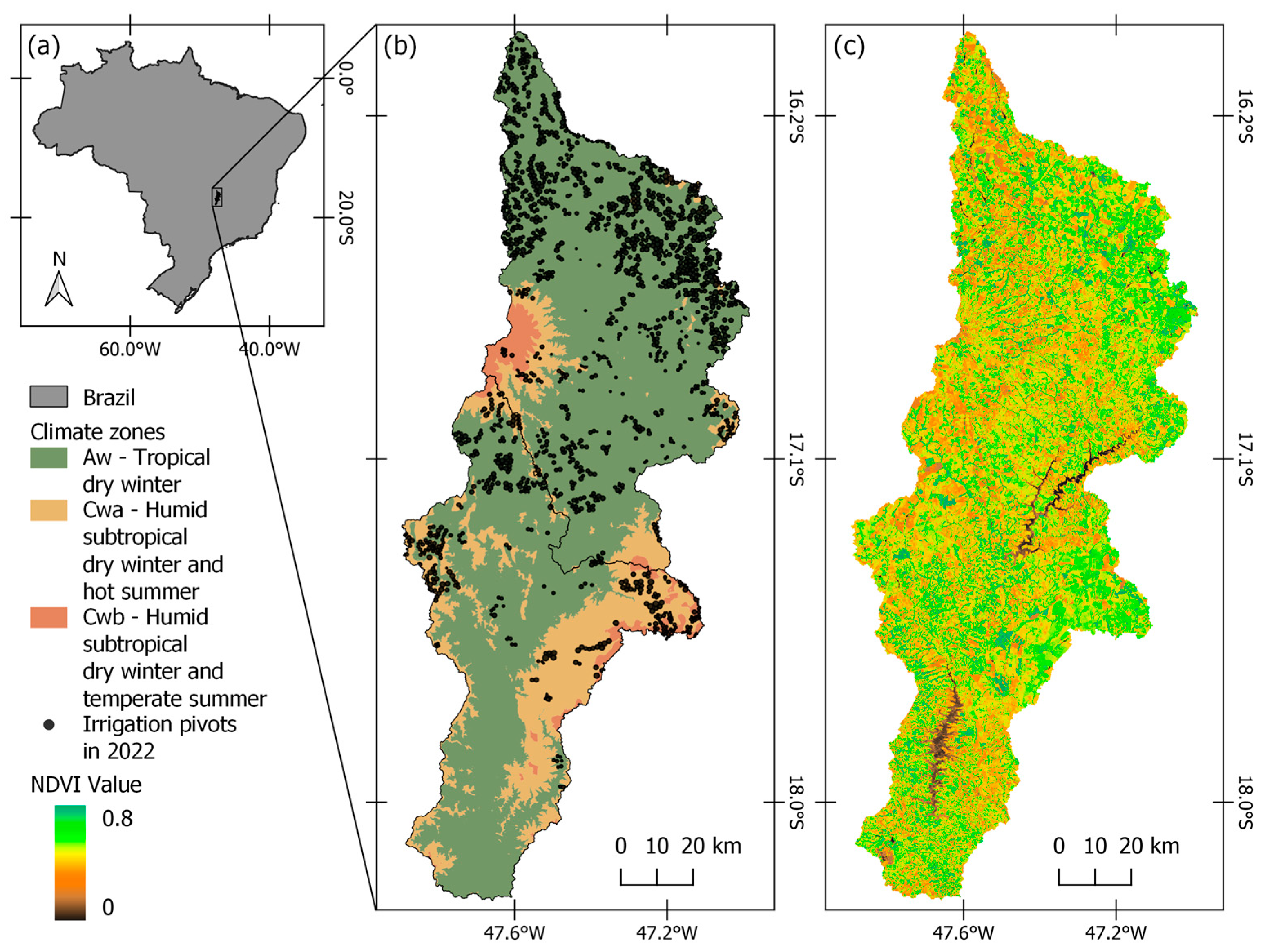
Figure 1. São Marcos River Basin: location in Brazil (a), climate zones according to Köppen–Geiger classification and irrigation pivots (b), and Normalized Difference Vegetation Index (NDVI) values computed using average composition of Landsat 8 for 2021 (c).
Remotesensing 16 03404 g001
Figure 2. Daily average of ET illustrated as boxplot for each land cover and use (a) for Landsat scenes between 1986 and 2022. We also illustrated the seasonal monthly average of ET (b), and trends of annual average ET for different land types, with natural vegetation (forest and savanna) demonstrating positive trends over the years, as well as irrigated areas (c).
Remotesensing 16 03404 g002
Figure 3. Changes in the ET spatial patterns for the São Marcos River Basin from 1986 to 2022 (a). The contribution of the water usage for each land cover and use between 1986 and 2022 is shown in (b), whereas (c) illustrates changes in land cover and use.
Remotesensing 16 03404 g003
Figure 4. Annual composition ET (mm day−1) in the São Marcus River Basin between 1986 (a) and 2021 (b). Highlighted plots showed the expressive number of pivot irrigation systems over the basin for specific locations.
Remotesensing 16 03404 g004
Figure 5. Monthly ET in the São Marcus River basin was analyzed for each month of one water year (2019 and 2020). During the dry season (May to September), precipitation is limited and radiation availability is high, being a water-limited environment. Consequently, lower ET values are observed during the dry season, while the wet season increases ET rates due to higher precipitation availability.
Remotesensing 16 03404 g005
Figure 6. Seasonal differences in daily ET for irrigated and rainfed croplands in the São Marcus River Basin (a), and the difference between both estimations (b). We used a simplified method to fill the gap between Landsat scenes by interpolating EF over time and multiplying with the respective reference ET.
Remotesensing 16 03404 g006
Disclaimer/Publisher’s Note: The statements, opinions and data contained in all publications are solely those of the individual author(s) and contributor(s) and not of MDPI and/or the editor(s). MDPI and/or the editor(s) disclaim responsibility for any injury to people or property resulting from any ideas, methods, instructions or products referred to in the content.