Article

The Remote Effects of Typhoons on the Cold Filaments in the Southwestern South China Sea

College of Meteorology and Oceanography, National University of Defense Technology, Changsha 410073, China
*
Author to whom correspondence should be addressed.
Remote Sens. 2024, 16(17), 3293; https://doi.org/10.3390/rs16173293
Submission received: 25 July 2024 / Revised: 26 August 2024 / Accepted: 30 August 2024 / Published: 4 September 2024

Abstract

:
Cold filaments (CFs) in the southwestern South China Sea (SCS) impact local hydrodynamics and the ecological environment. In this study, the effects of typhoons passing over the northern SCS on CFs are investigated using multi-source observational and reanalysis data. Statistical analysis of CF responses to typhoons over the past 24 years shows that during typhoon periods in the northern SCS, the CFs are intensified. We further analyze the remote effect of typhoons on the CF during Typhoon Kalmaegi in 2014, which caused a sea surface temperature (SST) drop of more than 3 °C in the CF region. The strengthened along-coast wind induced strong upwelling off the Vietnam coast. The maximum vertical velocity in the CF reaches three times the usual value. Meanwhile, influenced by the peripheral wind field of Kalmaegi, cold coastal water accumulated at the CF region due to the shafting of the offshore current. Both strong offshore currents and coastal upwellings enhanced the intensity of the CF. These findings demonstrate that typhoons not only directly affect ocean dynamic processes along their path but also present significant remote influences on coastal dynamics in other regions. This study enhances the understanding of CF evolution and sea–air interactions during extreme events.

1. Introduction

Cold filaments (CFs)—also known as cold tongues, plumes, or squirts—are characterized by narrow bands of cold water extending hundreds of kilometers [1,2]. These features are often associated with wind jets and strong offshore currents, and they play a significant role in the exchange of materials between nutrient-rich coastal waters and the oligotrophic open ocean [3]. CFs are commonly observed in the California Current System [4,5], off the coast of Iberia [6,7,8,9], in the southeast Atlantic Ocean [10], and, in particular, in the South China Sea (SCS), located in the Western Pacific, which is one of the largest marginal seas in the world [11].
Previous research has indicated that during the southwest monsoon period, southwestern South China Sea cold filaments (SWCFs) appear near the coast of Vietnam in the summer and autumn [12,13]. These CFs significantly impact the temperature, salinity distribution, and ecology of the SCS [14,15,16]. CFs typically occur between 8°N and 18°N off the east coast of Vietnam, primarily between 11°N and 12°N, and can extend eastward to the middle of the SCS [11]. They generally manifest as narrow and elongated arcs of cold water. The term “cold filament” was used to describe this sea temperature distribution by Xie et al. (2003) [17], and this distribution was called a “jet-shape region” by Zhao and Tang (2007) [18]. The surface water temperature within a CF can drop by more than 1 °C compared to the surrounding waters [19]. After forming in June, these cold-water masses extend eastward, spreading across much of the central SCS by July and August, with their maximum intensity (lowest temperature) occurring in August. By September, the extent and intensity of CFs diminish until they disappear. From spring to summer, the SCS’s sea surface temperature (SST) does not increase steadily with solar radiation; instead, it begins to decrease after the onset of the southwest monsoon period. This creates a distinct semiannual SST cycle, with CFs playing a dominant role. This cycle is crucial for marine circulation, biological activity, and regional climate variability in the SCS [20,21,22,23]. The heatwave event of 1998 was notably linked to an abnormal CF pattern in that year [17].
The formation of CFs is complex, being influenced by various factors such as the western boundary current [24], zonal offshore jets [25], upwelling [26], and dipoles [27] in the southern SCS during summer and autumn. Among these, the southwest wind (wind jet) has the most profound impact. It directly causes upwelling [28], which brings deep, cold water to the surface and reduces sea surface temperatures (SSTs), and it significantly influences the formation of dipoles [24]. The east-flowing jet between dipoles transports coastal cold water to the middle of the SCS, playing a crucial role in SWCF formation [17,29]. The wind jet is typically thought to be primarily influenced by the southwest monsoon period. However, recent studies have suggested that typhoons passing through the northern SCS may also have a remote influence on SWCFs. Liu et al. (2020) [30] found that the eastward coastal stream caused by southwest monsoons gradually disappeared due to the opposing wind vectors of Typhoon Mangkhut (2018). Additionally, the strengthening (or weakening) of winds around Typhoon Mangkhut and the northward (or southward) shift of cold (or warm) eddies in eastern Vietnam interrupted the eastward horizontal transport belt containing high concentrations of chlorophyll-a, thereby affecting the ecological environment of the southern SCS. This research introduced the concept of a “remote response”. Contradicting these findings, Li et al. (2021) [31] reported that during and after the passage of Typhoon Rammasun (2017), cold eddies along the eastern coast of Vietnam intensified and elevated subsurface cold waters, enhancing upwelling in the region. There have been limited investigations into the influence of typhoons on upwelling and SWCFs, with only the two studies mentioned above, and the underlying mechanisms remain unclear. While attention is typically focused on the regional influence of typhoons along their tracks, CFs are dynamic processes occurring at the sea-basin scale, making it challenging to relate the two. The aforementioned studies suggested that typhoons passing through the northern SCS at a local scale may impact SWCFs at the sea-basin scale along the east coast of Vietnam, approximately 10 degrees of latitude to the south. Further research focusing on the impact of individual typhoons on SWCFs could enhance the understanding of ocean–atmosphere interactions in the southern SCS and provide a more comprehensive understanding of the hydrodynamic and ecological environments of the SCS.
The aim of this study is to utilize remote sensing data, buoy data, and reanalysis products to analyze the effects of a typical typhoon on SWCFs. The remainder of this paper is organized as follows: Section 2 details the data sources and methods used in this study. In Section 3, we present cases of typhoons that passed through the northern SCS and had remote effects on SWCFs, focusing on a typical case—Typhoon Kalmaegi (2014)—to analyze the evolution of CFs after the typhoon’s passage. Section 4 provides a discussion of the findings. Finally, Section 5 summarizes the conclusions.

2. Data and Methods

2.1. Sea Surface Temperature

We utilized sea surface temperature (SST) products integrated with microwave and infrared optimally interpolated (MW_IR_OI) data obtained from Remote Sensing Systems (RSS). The MW_IR_OI data included SST measurements from the TRMM Microwave Imager [32], Advanced Microwave Scanning Radiometer [33], WindSat Polarimetric Radiometer [34], and GPM Microwave Imager [35]. Additionally, SST data detected in the infrared band via the Moderate-Resolution Imaging Spectroradiometer (MODIS) onboard the Terra and Aqua satellites as well as the Visible/Infrared Imaging Radiometer Suite (VIIRS) onboard the Suomi National Polar-orbiting Partnership were included.
Microwave imagers and radiometers can penetrate clouds, while the infrared channels of polar-orbiting satellite radiometers offer high spatial resolution. By combining these data sets through optimal interpolation (MW_IR_OI), we can overcome the challenges posed by severe weather, such as excessive cloud cover, and perform all-weather observations to obtain high-spatial-resolution SST data. This method is particularly effective when a typhoon is accompanied by extensive cloud cover [36]. In this study, we used daily data with a spatial resolution of 9 km × 9 km.

2.2. Sea Surface Height Anomalies and Surface Geostrophic Velocity

The sea surface height anomaly (SSHA) and sea surface geostrophic velocity data, derived from geostrophic relationships, were derived using satellite altimeter data from the SSALTO/DUACS multi-sensor gridded delay-time altimetry product, procured from Archiving, Validation, and Interpretation of Satellite Oceanographic Data (AVISO) and distributed by the Copernicus Marine Environment Monitoring Service (CMEMS). This comprehensive product was compiled from data obtained across a wide array of satellite altimeter missions (including but not limited to Jason-3, Sentinel-3A, HY-2A, Sar-al/AltiKa, Cryosat-2, Jason-2, Jason-1, Topex/Poseidon, Environmental Satellite, Geosat Follow-On, and European Remote Sensing satellites). The spatial resolution of the SSHA and geostrophic velocity data is 0.25° × 0.25° with a temporal resolution of 1 day, facilitating the detailed analysis and interpretation of oceanographic phenomena.

2.3. Wind Vectors

The wind vector data sets included wind vectors at 10 m above the sea surface, sourced from cross-calibrated multi-platform gridded surface vector winds provided by Remote Sensing Systems (RSS). The Cross-Calibrated Multi-Platform (CCMP) combines Version-7 RSS radiometer wind speeds, Quick Scatterometer (QuikSCAT), Advanced Scatterometer (ASCAT) wind vectors, moored buoy wind data, and ERA-Interim model wind fields. Using a variational analysis method, this combination merges satellite observations and in situ wind measurements to create gap-free wind fields, resulting in four daily maps of 0.25°-gridded vector winds. Consequently, the wind field data used in this study have a temporal resolution of 6 h and a spatial resolution of 0.25° × 0.25°.

2.4. Reanalysis Data

The sea temperature and salinity reanalysis data were obtained from the Hybrid Coordinate Ocean Model (HYCOM) of the Navy Coupled Ocean Data Assimilation (http://hycom.org, accessed on 3 September 2024). This data set has a spatial resolution of 0.08° × 0.08° and a temporal resolution of 1 day. HYCOM is a widely utilized and highly regarded data set. For this study, we also employed in situ data from a cross-shaped array comprising five stations, including five moored buoys and four subsurface moorings. Detailed information can be found in Zhang et al. (2016) [37]. To evaluate the temperature and salinity profiles, we compared in situ data from Station 2, Station 4, and Station 5 (Figure 1). The HYCOM data demonstrated good agreement with the buoy data. The exact location of the buoy can be referenced in Figure 2b.

2.5. Calculation of Ekman Pumping

For this research, we needed to calculate the upwelling caused by Ekman pumping. Price (1981) [38] proposed the following Ekman pumping formula (Equation (1)):
u p w = × ( τ / ρ f ) ,
where f is the Coriolis parameter, ρ = 1020 kgm−3 is the density of seawater, and τ is the wind stress vector, which can be calculated using Equations (2) and (3) as follows:
τ = ρ a C D U 10 U 10 ,
C D = ( 4 0.6 U 10 ) × 10 3 f o r   U 10 < 5   m / s   ( 0.737 + 0.0525 U 10 ) × 10 3 f o r   5   m / s     U 10 < 25   m / s 2.05 × 10 3   f o r   U 10 25   m / s
where ρa = 1.26 kgm−3 is the density of air, CD is the drag coefficient [39,40], and U10 is the 10 m wind vector. Various equations for calculating CD over the ocean surface have been proposed [40,41]. In this context, the expression used in this research to compute CD was based on recent results from field experiments in hurricanes, in which the saturation of CD at wind speeds between 25 and 35 m/s was observed [41,42,43].

2.6. Cold Filament Identification

Due to the annual variability in monsoon intensity and solar radiation, there are differences in SST and CF intensity in the SCS each year. For instance, in 1998, influenced by El Niño, the monsoon was weaker, and no cold filaments were observed throughout the year [25]. Additionally, the intensity and shape of cold filaments can vary within a season in response to fluctuations in monsoon pulses [25], showing periods of strengthening and weakening, which is why there is no clear definition. We attempted to use temperature gradients to determine the location of cold filaments [1,9]. However, this method primarily targets weak and narrow cold filaments and is not suitable for those intensified by typhoons during the summer and autumn seasons in this study. In this paper, we refer to the definition by Li et al. (2014) [44], where cold filaments are described as having temperatures 1–2 °C lower than the surrounding waters in the southern SCS. By averaging the SST in the southwestern SCS during September 2014, we found that the 27.5 °C isotherm aligns reasonably well with the −1 °C SSTA contour, effectively representing both the weaker cold filaments before typhoons’ arrival and their intensified state afterward. Therefore, in this study, we define the extent of the cold filaments as the water mass with temperatures below 27.5 °C.

3. Results

3.1. Statistics of Typhoons Passing Northern SCS Affecting SWCFs
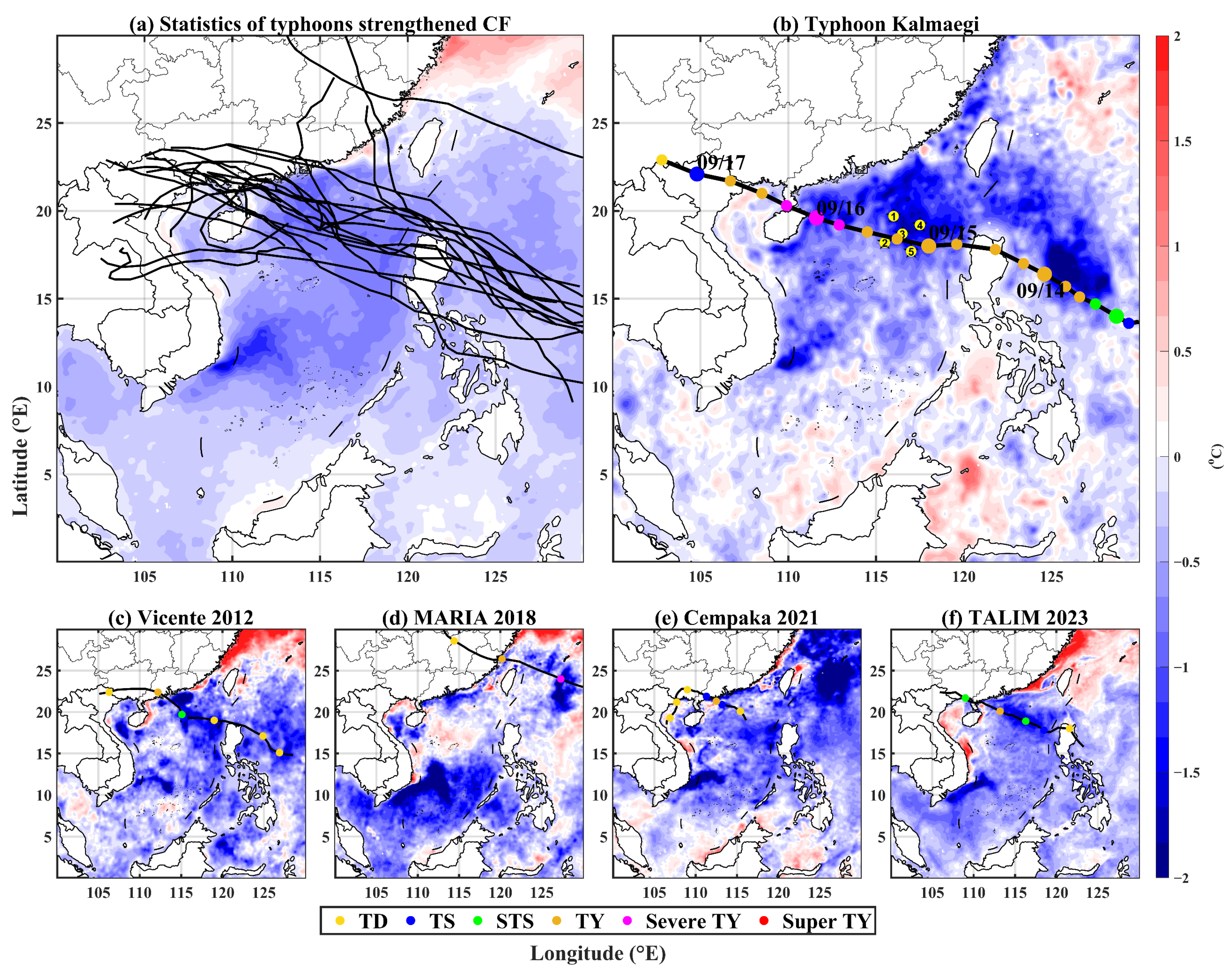
According to the typhoon data set released by the China Meteorological Administration (CMA), we analyzed typhoons that passed through the northern SCS from 2000 to 2023. We calculated the difference in the five-day SST average before and after their passage and found that 20 typhoons had a significant impact on the SWCFs (Table 1). After the typhoons passed through the northern SCS, areas nearly 10 latitudes south of their paths along the east coast of Vietnam experienced a cooling enhancement of more than 2 °C. Additionally, the area between 108°E and 114°E, 10°N and 14°N experienced a cooling of more than 0.4 °C (Table 1). We selected five typical cases (Figure 2b–f) for presentation. Among these, the severe Typhoon Kalmaegi, which passed through the northern SCS in September 2014, was chosen for a more detailed study. First, the SWCF significantly strengthened after this typhoon passed through the SCS, extending from 110°E to 113°E. Second, Kalmaegi passed through a buoy array, providing comprehensive observation data that could be used to validate the reanalysis data set employed in our study.
In the past decade, many typical typhoons affecting CFs have been observed in the SCS. Kalmaegi (2014) is a representative case, as the deployment of a buoy array in the SCS during this case provided clear and precise records of the upper-ocean changes induced by the typhoon. These data offered robust support for our research.
Figure 2. (a) The 20 typhoon tracks (black solid lines) provided by the China Meteorological Administration (CMA) that enhanced cold filaments (CFs). The color shading represents the average sea surface temperature (SST) difference between five days before and after the passage of typhoons. (bf) The black solid lines represent the typhoon tracks, with dots indicating the typhoon positions at six-hour intervals. Large dots denote the typhoon’s position at 00:00, while small dots indicate the positions at 06:00, 12:00, and 18:00. The color of the dots represents the typhoon’s intensity, with yellow dots in (b) indicating the buoy positions. The color shading represents the SST difference between five days before and after the passage of the typhoons.
Remotesensing 16 03293 g002

3.2. Case of Typhoon Kalmaegi

Typhoon Kalmaegi formed as a tropical depression on the night of 10 September 2014 (UTC), near 10°N and 141°E. It then traveled northwestward, becoming a tropical storm on 12 September (UTC), and finally intensified into a typhoon on 14 September (UTC), with maximum sustained winds of approximately 70 knots (~36 m/s). The typhoon weakened by around 5 knots (~2–3 m/s) while crossing the Philippines but reintensified to 70–75 knots (~36–38 m/s) as it moved over our observational array on 15 September (UTC) (Figure 2b). Subsequently, Typhoon Kalmaegi gradually decreased in size after making landfall over southern China and Vietnam.
Typhoon Kalmaegi passed directly over a cross-shaped observational array deployed in the northern SCS, providing unprecedented ocean measurements of typhoon-induced variations in upper-ocean currents, temperature, and salinity, as well as meteorological variables. These data are unique, as the eye of the typhoon passed almost directly over the center of the array, with two moorings on each side of the storm. This configuration allowed us to investigate changes in oceanic and atmospheric variables on both sides of Typhoon Kalmaegi. Previous research has extensively studied typhoon-induced ocean responses, including upper-ocean circulation [45], ocean waves [46], temperature [37], and thermal structures [46], as well as meteorological elements [47] such as air temperature, pressure, humidity, wind vectors, and heat flux. These studies have revealed the interactions between Typhoon Kalmaegi and the upper ocean layer of the SCS; however, there remains a lack of research on the remote response of SWCFs relative to Typhoon Kalmaegi. Investigating Typhoon Kalmaegi’s remote impact on SWCFs will contribute to a deeper understanding of the air–sea interaction mechanisms of SWCFs. In this study, the buoy data from Kalmaegi were used to test the accuracy of HYCOM reanalysis data, thus improving the credibility of the reanalysis data and enabling deeper exploration of the SWCF-strengthening process associated with Typhoon Kalmaegi.

3.3. CF Response to Typhoon Kalmaegi

3.3.1. SST Variation during the Passage of Typhoon Kalmaegi in the Southwestern SCS

During the summer and autumn seasons, when the southwest monsoon prevails, CFs are commonly observed near the Vietnam coast. A detailed analysis of the SST distribution in the southern SCS during the period when Typhoon Kalmaegi was active revealed significant changes. Prior to the impact of the typhoon, the CF exhibited a relatively confined geographical extent and a higher temperature. On 9 September, the CF temperature was approximately 28 °C and did not extend beyond 110°E in longitude (Figure 3a). Starting from 12 September, its temperature began to drop below 28 °C, and its geographical extent gradually expanded. This growth reached its peak on 16 September, when the CFs extended northeastward to coordinates of 114°E and 16°N, with temperatures falling below 26 °C (Figure 3h).
The intense enhancement of this SWCF has sparked significant interest, particularly given that its location was approximately 10 degrees of latitude away from the typhoon’s path. Notably, areas to the north in the SCS that were closer to the typhoon’s path did not experience cooling as strongly as the SWCF region. The mechanism behind this enhancement of the SWCF is explored in the following sections.

3.3.2. Wind Stress Curl and the Upwelling Response of the Southern SCS

As the SWCF was a result of the southwest monsoon and an outcome of atmosphere–ocean interactions, we first examined the changes in wind stress during Typhoon Kalmaegi. An analysis of daily variations in SST and wind stress curl along the 13°N latitudinal profile (Figure 4a,b) revealed a significant increase in wind stress curl along the eastern coast of Vietnam on 15 September—when Typhoon Kalmaegi entered the SCS—reaching 9 × 10⁻⁶ N·m−3 (Figure 4b). This positive wind stress curl induced upwelling, which transported the wind-induced positive vorticity downward into the CF area. As a result, the SST near 112°E dropped from 28 °C on 15 September to 26 °C on 16 September, with the cooling effect lasting for more than a day (Figure 4a). The regions of reduced SST in Figure 4a correspond to the areas of increased wind stress curl in Figure 4b, with a slight lag behind the increase in wind stress curl. This correlation confirms that the enhanced wind stress curl brought by Typhoon Kalmaegi to the eastern coast of Vietnam intensified upwelling in the SWCF zone, thereby strengthening its intensity and extent.
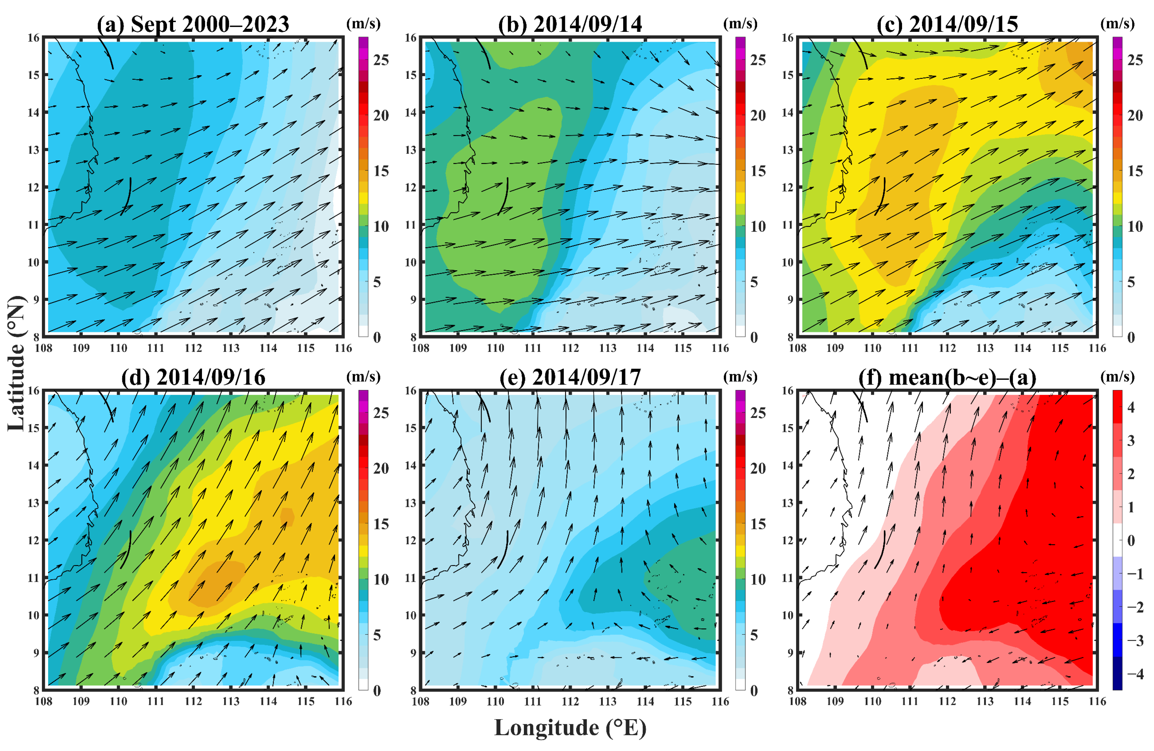
Prior to the ingress of Typhoon Kalmaegi into the SCS from 10 to 14 September (Figure 4c), a southwesterly monsoon prevailed along Vietnam’s eastern seaboard, with wind speeds below 10 m/s. After Typhoon Kalmaegi entered the SCS (Figure 4d), coastal wind speeds increased significantly, reaching a maximum of 18 m/s—nearly twice the speed observed before the typhoon’s arrival. Following landfall (17 to 20 September, Figure 4e), while the influence of Typhoon Kalmaegi’s influence diminished near the Vietnamese coast, the southwesterly monsoon pattern did not revert to its pre-typhoon state. Additionally, the arrival of Typhoon Fung-wong impacted most of the SCS. As shown in Figure 4d, the sudden strengthening of wind speeds along the east coast of Vietnam was connected with the peripheral wind field of Typhoon Kalmaegi, indicating that the increased wind speeds during this period were caused by the typhoon.
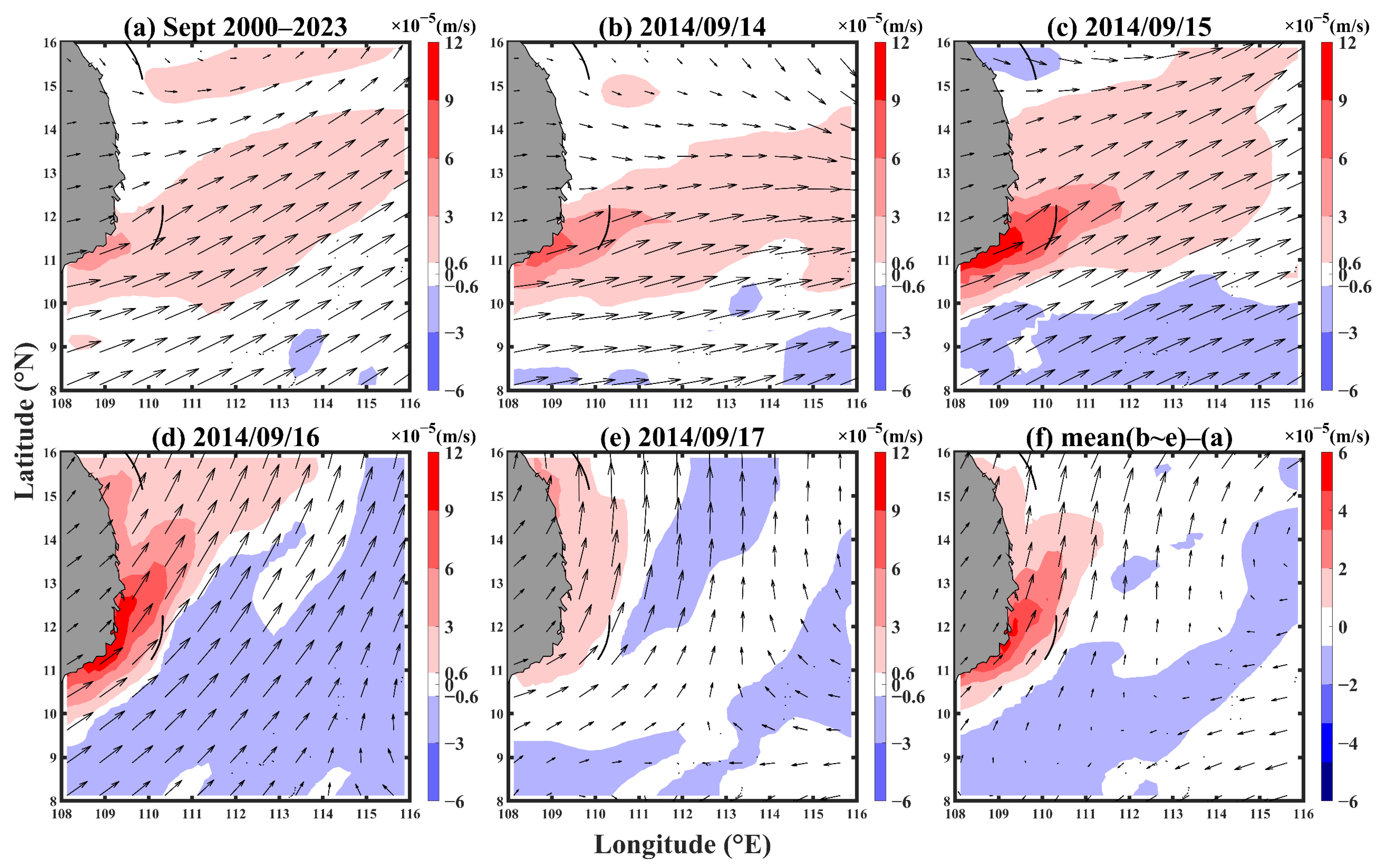
To further investigate the Ekman pumping effect in this region, an analysis of the average wind field and upwelling for the month of September from 2000 to 2023 was conducted and subsequently compared with the daily wind fields during the typhoon period (Figure 5 and Figure 6). In the average September state, the upwelling off the east coast of Vietnam was very weak. The longitude of the area with upwelling above 3 × 10⁻⁵ m/s only extended to around 110°E, and the latitude did not exceed 12°N (Figure 5a). The maximum upwelling intensity was only 5 × 10⁻⁵ m/s (4.32 m/day), caused by the weak monsoon in September. During this period, the wind direction along Vietnam’s east coast was southwesterly, with wind speeds ranging from 8 to 10 m/s and decreasing to 2–4 m/s in the 115–116°E region (Figure 6a). However, during Typhoon Kalmaegi, the wind speed and upwelling along the eastern coast of Vietnam significantly intensified compared to the average state. The wind speed on the east coast of Vietnam reached a maximum of 14 m/s during the typhoon (Figure 6c), while the wind speed in the eastern open sea reached 16 m/s (Figure 6d). The difference between the wind speed during the typhoon and the average September state was positive, with open-sea wind speeds increasing by more than 4 m/s. There was a gradual decline in wind speed toward the Vietnamese coast, forming a positive curl (Figure 6f), and the wind direction shifted more northerly compared to the September climate. Corresponding to the increased wind speeds, upwelling also greatly intensified during Typhoon Kalmaegi, reaching a maximum of 8 × 10⁻⁵ m/s on 14 September (Figure 5b) and 1.4 × 10⁻⁴ m/s on 15 and 16 September (Figure 5c,d), nearly tripling in intensity. The area of significant upwelling extended to 112°E for regions with upwelling above 3 × 10⁻⁵ m/s. During the typhoon, the maximum upwelling increase over the east coast of Vietnam was 6 × 10⁻⁵ m/s (Figure 5f), more than double the average state. The area of enhanced upwelling corresponded to the regions where the SST declined.
Additionally, it was observed that there was a decrease in SST around 10°N, 112–114°E. By comparing the upwelling and wind speed changes in this region during Kalmaegi, we found that although the upwelling caused by the typhoon did not extend to this area (Figure 5f), the high wind speeds during Kalmaegi (Figure 6d–f) corresponded to the cooler SST observed near 10°N, 112–114°E. Notably, in Figure 6f, wind speeds in this region increased by more than 5 m/s during Kalmaegi, leading us to infer that intense mixing driven by these high winds likely reduced SST. However, after the typhoon passed, surface wind speeds quickly decreased (Figure 4e), and since the CF region is located in a low-latitude area (10°N), strong solar radiation rapidly caused the SST to rebound near 10°N, 112–114°E (Figure 3i–l).
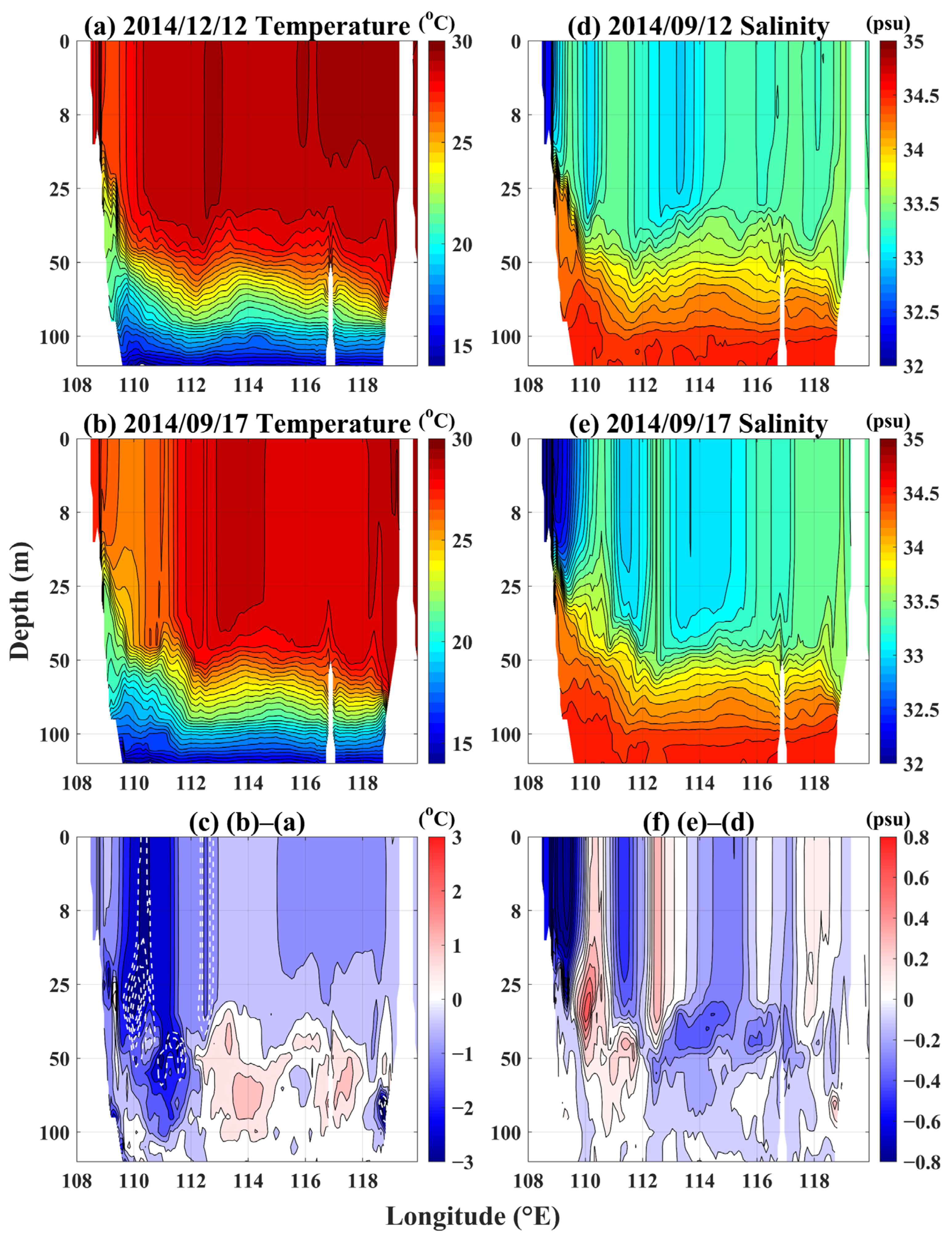
The temperature and salinity profile at 11°N were analyzed (Figure 7a–c) in order to further investigate the influence of Ekman pumping on the enhancement of the CF. Prior to the arrival of Typhoon Kalmaegi on 12 September (Figure 7a), the sea temperature near the east coast of Vietnam (approximately 109°E) was around 26 °C, while the temperature in the eastern sea area was about 28 °C, indicating that the SWCF was approximately 2 °C cooler than the surrounding sea. After the passage of the typhoon on 17 September (Figure 7b), an expansion of the CF zone was noted, with an upward movement of the isotherms. The 24 °C isotherm rose by more than 20 m, and the 25 °C isotherm increased by more than 30 m. The cooling in the CF reached more than 3 °C (Figure 7c), and the cold-water area (below 27 °C) expanded to 112°E. The latitudinal temperature profile suggested that the robust upwelling caused by the typhoon was one of the factors contributing to the cooling and expansion of the CF.
Upwelling brings deep, cold, and salty water to the upper ocean. Thus, the change in the salinity profile under the influence of upwelling should generally oppose the trend seen in the temperature profile; that is, the salinity of the upper ocean should increase. However, the actual salinity distribution presents a different picture (Figure 7d–f). After the passage of Typhoon Kalmaegi, the salinity of the upper ocean did not increase significantly over a large area but showed a clear decreasing trend near the shore. The area where salinity increased above 0.2 psu corresponded with the area where the temperature decreased by more than 2.5 °C (Figure 7c), particularly in the core region where salinity increased above 0.6 psu (110°E, 27 m), which is consistent with the maximum cooling area. This indicates that strong upwelling does carry deep, high-salinity water to the upper ocean; however, the presence of fresh water with lower salinity inhibits the increasing salinity trend in areas with milder upwelling. At 111°E, upper salinity decreased while lower salinity increased. This phenomenon suggests that the lower salty water in this area increases with mild upwelling but is inhibited by the upper fresh water transported from elsewhere. To confirm this hypothesis, the salinity anomaly is further discussed through analyzing the sea level anomaly (SLA) and sea surface current field in the following section.

3.3.3. SLA and Sea Surface Current Response of SWCF Area

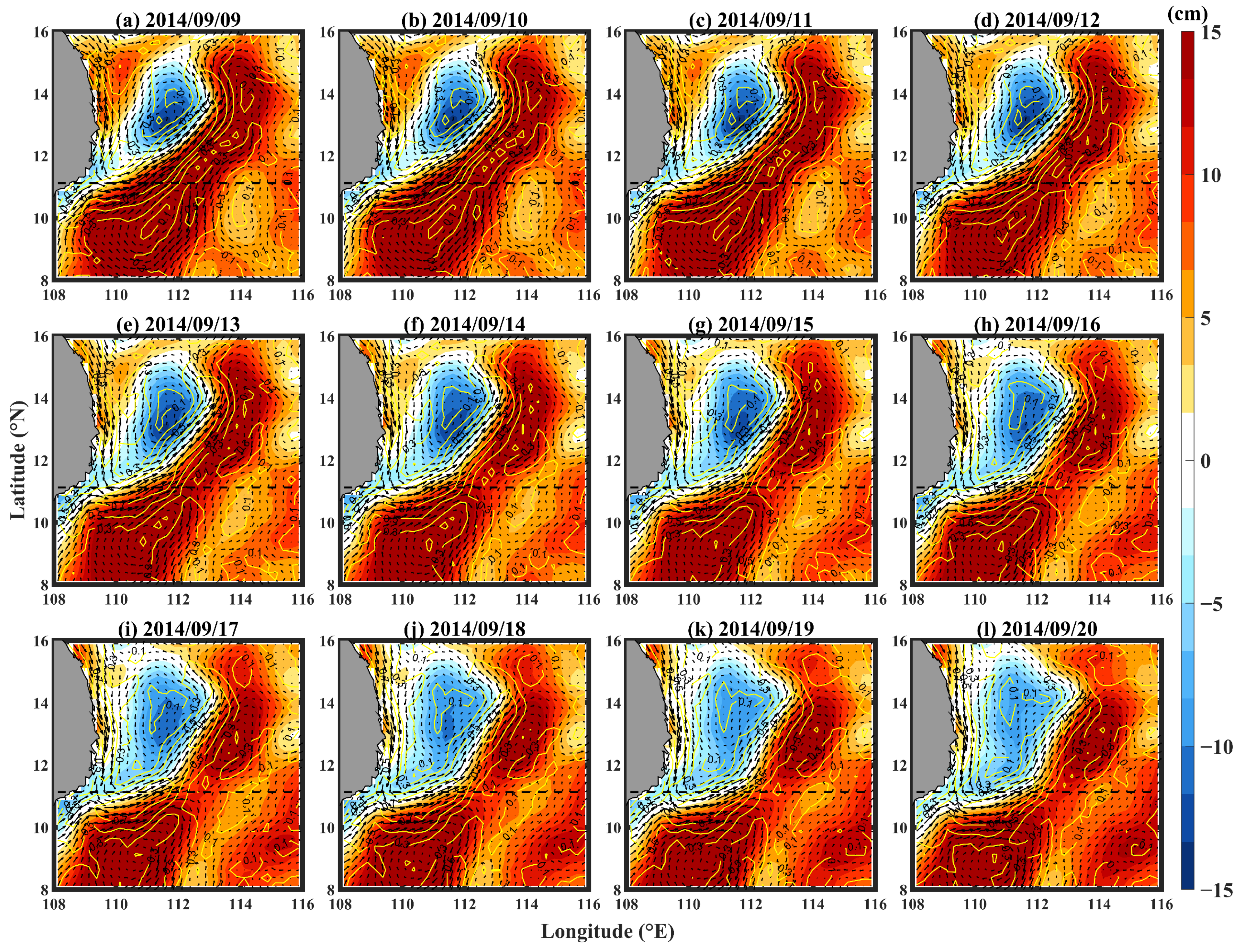
Before the typhoon entered the SCS, a cold eddy was present off the east coast of Vietnam, accompanied by a warm eddy to its southeast, forming a dipole. This dipole is a crucial component of the summer circulation in the SCS, primarily driven by the prevailing southwest monsoon during summer and autumn [24]. Between the dipoles, a sea surface current flows from southwest to northeast with a velocity of 0.7 m/s (Figure 8a). A comparative analysis before and after the typhoon’s impact on the southern SCS (Figure 8a–h) reveals that the offshore current off the eastern coast of Vietnam gradually shifted easterly from its initial southwest–northeast direction. This shift is attributed to northerly winds during the typhoon, which caused easterly Ekman transport, resulting in the offshore current’s deflection to the east. The current on the east coast of Vietnam first shifted eastward and then to the northeast, with the velocity in the eastern part maintained above 0.7 m/s, while that in the northeast part weakened to below 0.6 m/s. This change caused the cold and fresh nearshore water to impact the South Vietnam (SV) eddy, accumulating there and altering the dipole distribution. One of the most noticeable phenomena is the expansion of the cold eddy. This expansion eroded the SV eddy from the middle, reducing both its extent and amplitude, eventually splitting it into two warm eddies to the southwest and northeast (Figure 8i). Concurrently, the cold eddy expanded northwestward, absorbing the nearby warm eddy. It is noted that although the cold eddy’s range expanded, its amplitude decreased. This is because the SLA is influenced by both temperature and salinity. While the low temperature of the nearshore seawater expands the cold eddy and erodes the surrounding warm eddies, its fresh characteristics are not conducive to reducing the SLA, resulting in a decrease in the cold eddy’s amplitude.
Although the amplitude of the cold eddy core decreased (<5 cm), the SLA along the coast of Vietnam exhibited a downward trend, with a general decrease of more than 10 cm and over 20 cm at the center of the SV eddy. The expansion area of the cold eddy corresponds well with the decrease in SST, indicating that the northerly wind during the typhoon caused the offshore flow to deflect eastward, leading to the accumulation of cold and fresh water near the shore. This is one of the significant factors contributing to the changes in temperature and salinity in the CF region. The expansion of the cold eddy in the dipole structure, although significant, led to a decrease in the amplitude of the cold eddy center due to the nearshore water with lower salinity. In addition, the northern warm eddy near the coast was absorbed and displaced which, in turn, enhanced the scope and intensity of the SWCF.

3.3.4. Three-Dimensional Temperature and Salinity Variation of the SWCF

Further analysis of the temperature and salinity profiles off the eastern coast of Vietnam corroborates the previous conclusions. Before Typhoon Kalmaegi entered the SCS (12 September, Figure 9a), the area with SST below 27 °C off the eastern coast of Vietnam was very limited, with its core area located at 11°N. This latitude marks the boundary between the cold and warm eddies along the eastern coast of Vietnam and serves as the starting point for the offshore current. In the northern part of the SWCF, water temperatures above 20 m were mostly maintained above 27 °C, and the distribution of the cold-water arc matched the location of the offshore current (Figure 8d). During the passage of Kalmaegi (16 September, Figure 9b), the range and intensity of the cold eddy increased. The water temperature above 30 m dropped, with areas below 26 °C extending even to 112°E. At this time, the distribution of the cold-water arc aligned with the offshore current’s path (Figure 8h): first eastward and then northeastward. The temperature in the offshore current area dropped by more than 2 °C (Figure 9c). Notably, in the northern part of the SWCF, from the eastern coast of Vietnam extending eastward near 110°E, the temperature decreased by more than 2 °C, corresponding to the area where upwelling increased (Figure 5e). These two cooling locations, respectively, correspond to the offshore current and upwelling regions, indicating that the enhancement of the cold eddy and SWCF during Kalmaegi was influenced by these two physical processes.
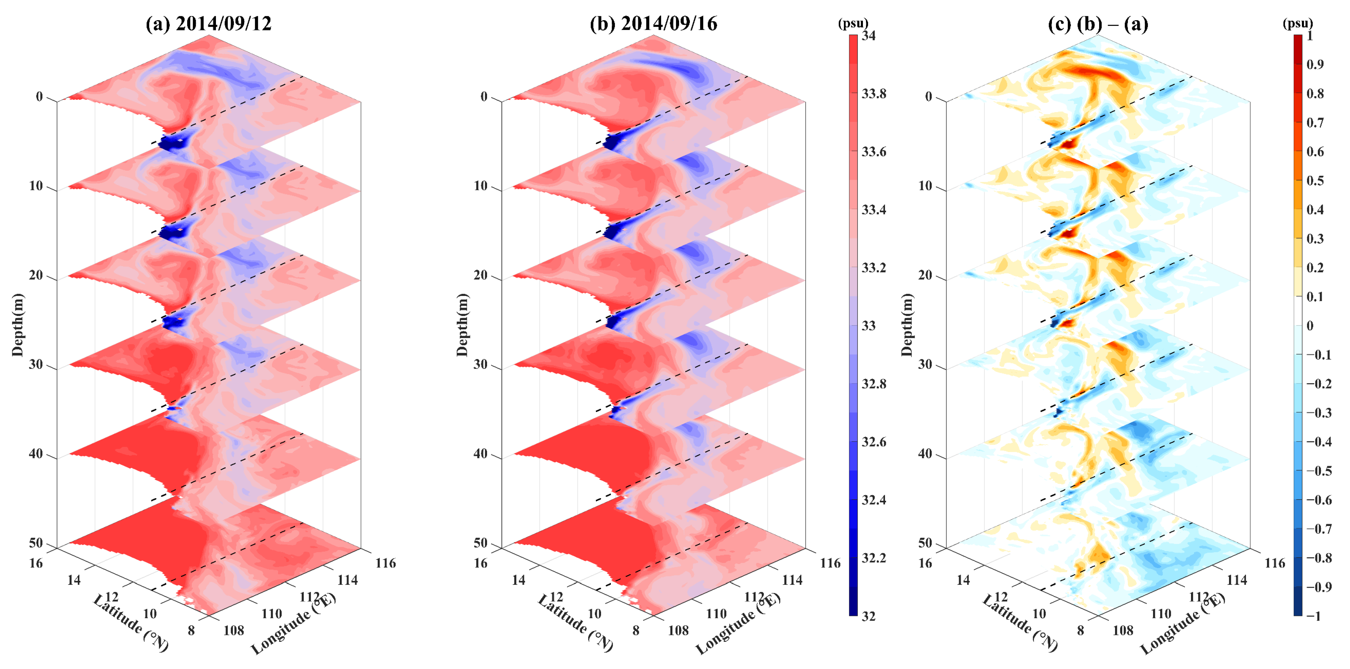
The three-dimensional changes in salinity differ significantly from the temperature changes, suggesting that in addition to upwelling, another mechanism influences the distribution of upper-ocean elements along the coast of Vietnam. Before Kalmaegi reached the SCS, the high-salinity region (Figure 10a) corresponded to the low-temperature region (Figure 9a), both aligning with the offshore current’s range on 12 September. At 11°N, which is the boundary between the dipole’s cold and warm eddies, the northern part exhibited a cold eddy with higher salinity at above 33.2 psu, while the southern part had lower salinity due to the influx of low-salinity fresh water from the continental runoff south of 11°N along the eastern coast of Vietnam.
After Kalmaegi passed through the SCS, the salinity distribution changed (Figure 10b). In particular, salinity decreased in the eastward-flowing part of the offshore current, while it increased on its southern and northern sides. The causes of salinity changes are more complex when compared to temperature changes, as both upwelling and offshore currents can lead to decreases in SST. However, upwelling increases upper-ocean salinity, while offshore currents have the opposite effect. Thus, the salinity distribution is determined by the competition between these two mechanisms. Near 11°N, within the offshore current, freshwater accumulation outweighed the upwelling mechanism, resulting in decreased salinity. Conversely, to the south and north of the current, off the Vietnam coast, the upwelling mechanism was stronger than freshwater accumulation, resulting in increased salinity.

4. Discussion

CFs constitute a physical process with a life cycle lasting several months. Through the use of monthly averaged satellite remote sensing data of SST and SLA from 2000 to 2023 in the southern SCS (Figure 11), it was observed that with the onset of the monsoon transition each year in June, the dipole appears, causing the SST along the eastern coast of Vietnam to start decreasing. By July, the cold and warm eddies within the dipole further develop, and the SWCF extends from the eastward jet between the dipole from nearshore to offshore (Figure 11b,g). By August, the dipole reaches its most mature state, and the SWCF extends to its farthest point (Figure 11c,h). With the weakening of the monsoon, the dipole begins to decline in intensity in September, and the CF gradually weakens until it disappears (Figure 11d,i). The fundamental cause underlying the CF’s formation is the prevailing southwest monsoon in the southern SCS during the summer and autumn seasons, directly triggered by the upwelling and the eastward jet between the dipole’s cold and warm eddies. It is observed that the CF (the region of low SST) does not overlap with the cold eddy (the region of low SLA) in Figure 11, which precisely confirms that the formation of the CF is due to the eastward jet between the dipoles carrying cold water [27]. Typhoon Kalmaegi occurred in September, when the CF was relatively weak. At this time, the southwest monsoon intensity was lower, but the arrival of Kalmaegi increased wind speeds over the eastern coast of Vietnam, enhancing the CF and dipole.
Indeed, the life cycles of SWCFs, dipoles, and monsoons last for several months, even up to half a year, and the dipoles and SWCFs are products of basin-scale ocean movements. In contrast, the life cycle of a typhoon is only a few days, with its passage through the SCS taking just about 2–4 days, thus affecting a more regional area [48,49,50]. Whether a small-scale typhoon can influence a basin-scale SWCF is a question worth exploring, requiring daily investigations of the intensity of the SWCF.
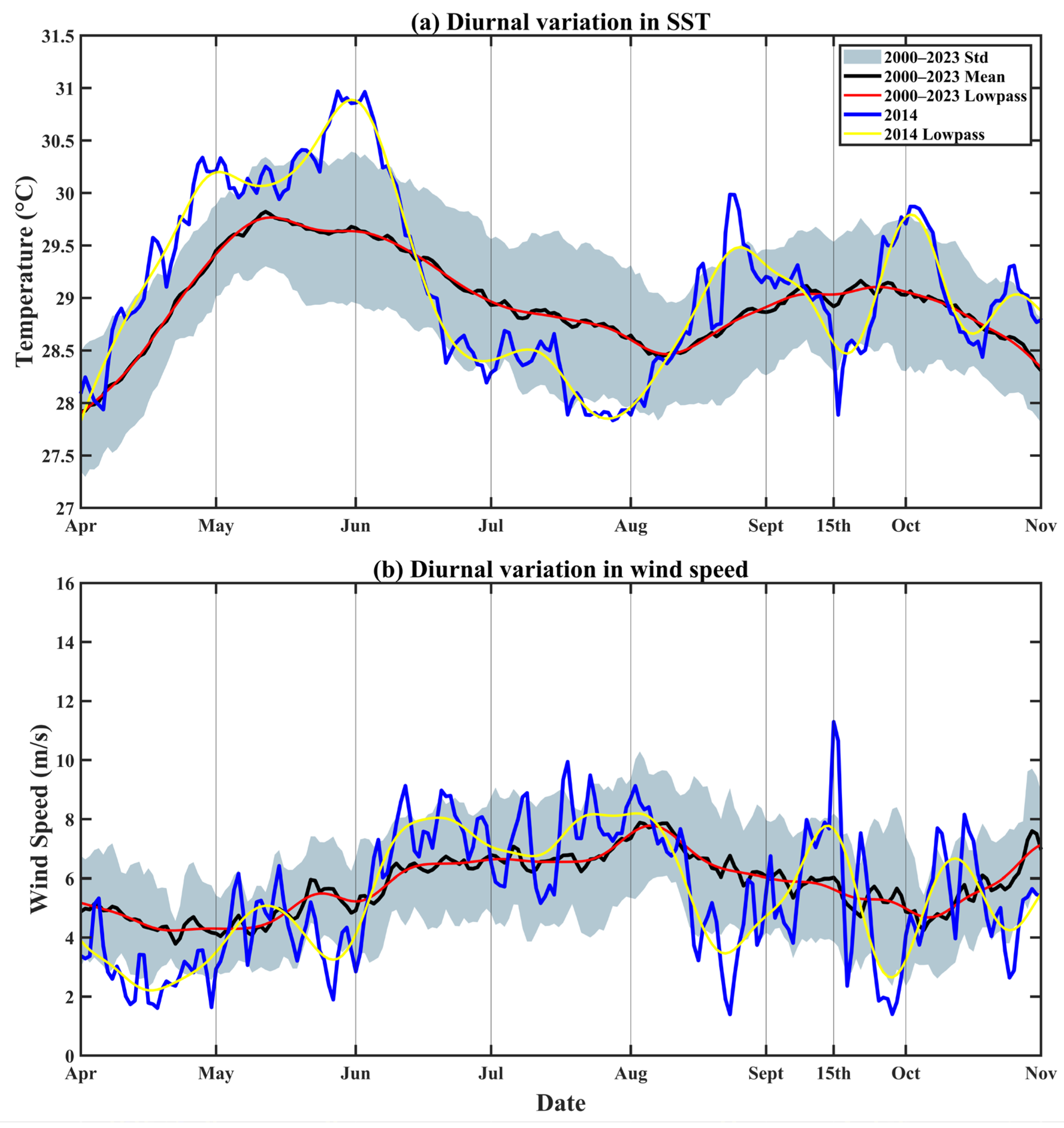
By utilizing satellite remote sensing data, we calculated the average daily SST and wind speeds (Figure 12) from 2000 to 2023 in the region between 108°E–114°E and 10°N–14°N, corresponding to the CF area during Typhoon Kalmaegi. The 24-year average SST variation (Figure 12a, black solid line) aligned with the 30-day lowpass filter (Figure 12a, red solid line), indicating that the SST variation in the southwestern SCS predominantly follows an intraseasonal cycle. Starting in April, the sea temperature in the southwestern SCS begins to increase and then starts to decline in May, reaching its lowest point in July and August and then increasing again and beginning to decline in September. We found that low SST values correspond well with high wind-speed values (with some lag), confirming that the southwest monsoon is the fundamental cause of SWCF formation. On 15 September 2014, wind speeds dramatically increased, with the regional average wind speed reaching nearly 12 m/s—almost double the 24-year climatic average. Additionally, the SST and wind speed oscillations during the Kalmaegi period significantly exceeded the 30-day filtered distribution observed in 2014 (Figure 12, yellow solid line). Correspondingly, the SST lagged by one day was more than 1 °C lower than the historical average. This was due to Kalmaegi entering the SCS, increasing wind speeds along the eastern coast of Vietnam and thereby enhancing the CF. Comparing wind speed distributions during this period revealed that the high-wind-speed area along the eastern coast of Vietnam connected with the periphery of Typhoon Kalmaegi (Figure 4d), indicating that the high wind speeds during the CF enhancement period were induced by Kalmaegi. This also indicates that although typhoons have relatively short life cycles, their intense nature exerts a significant impact on both atmospheric and oceanic circulation at the basin scale. There is currently limited research on similar conclusions [51,52,53,54], highlighting the need for further investigation to deepen our understanding of the influence of typhoons on the atmosphere and ocean.
For this study, we initially calculated the upwelling caused by strong winds and hypothesized that the expansion and intensification of the SWCF are a result of upwelling caused by Kalmaegi. The changes in wind stress curl, upwelling speed, and temperature profiles support this mechanism. However, the salinity profile exhibited a trend contrary to that caused solely by upwelling, prompting us to consider whether another mechanism might be simultaneously affecting the southwestern SCS.
Wang et al. (2006) [24] used a 2.5-layer model to simulate the southern SCS in summer and autumn, finding that the dipole along the eastern coast of Vietnam could form and develop a CF even without upwelling, although it was weaker than in reality. Similarly, during Kalmaegi’s passage through the SCS, the sea surface current between the dipole was deflected and blocked at the turning point, causing cold and fresh water accumulation, thereby enhancing the SWCF’s intensity and expanding its range. Therefore, the fundamental reason for Typhoon Kalmaegi’s ability to induce CF enhancement is that the typhoon increased wind speeds over the eastern coast of Vietnam, with the direct cause being intensified upwelling and offshore currents.
Kalmaegi serves as a representative example of typhoons identified to intensify SWCFs. This mechanism requires further exploration through additional case studies in order to verify its universality. Moreover, the specific contributions of upwelling and offshore currents to the intensification of SWCFs, as well as the direct impact of typhoons on this enhancement, need to be investigated further using numerical models and sensitivity experiments. This will be the next phase of our research.

5. Conclusions

Using satellite remote sensing data and reanalysis products, this study briefly cataloged typhoons passing through the northern SCS that had an enhancing effect on SWCFs in the southern SCS. We used observed buoy data to correct the HYCOM data and selected Kalmaegi in 2014 for a case study. Through analyzing the sea surface wind field, sea surface current field, SLA, and upper-ocean temperature–salinity distribution, we explored the mechanism by which Kalmaegi affected the enhancement of the SWCF. The main conclusions are as follows.
During and after the passage of Typhoon Kalmaegi, a cold-water arc with temperatures below 28 °C emerged off the eastern coast of Vietnam, extending from the shoreline to the open ocean. Climatological statistics show that in September, the SWCF typically does not extend beyond 110°E and remains warmer than 28 °C; however, the arrival of the typhoon intensified this phenomenon, reducing the minimum temperature to below 27 °C and stretching it eastward to 112°E. The fundamental reason for the strengthening of the SWCF is the increased wind speed in the southern SCS caused by Kalmaegi. Before Kalmaegi entered the SCS, the wind speed along the eastern coast of Vietnam was less than 10 m/s; meanwhile, after its entry, the wind speed increased to a maximum of 18 m/s. The high wind speeds affect the SWCF enhancement through two main mechanisms. First, during the typhoon, upwelling along the eastern coast of Vietnam more than doubled, transporting cold, salty water from the deep ocean to the upper layers, thus strengthening the SWCF. Second, the northerly wind direction caused the offshore current between the dipoles to deflect eastward, impacting the SV and resulting in the accumulation of cold fresh water along the coast. This expanded the cold-water mass with respect to both its range and amplitude.
The combined effect of upwelling and offshore currents increased the intensity of the CF and further expanded its range, thus eroding the SV eddy of the dipole. Both the upwelling and offshore currents reduced the temperature but exhibited opposite effects on salinity. Upwelling introduced high-salinity deep water to the surface, increasing upper-layer salinity, while offshore currents transported and accumulated nearshore fresh water, leading to decreased salinity. During Kalmaegi, the salinity changes along the eastern coast of Vietnam were influenced by the competitive mechanisms of these two processes: salinity decreased in the eastward current region, while it increased to the north and south of the current. The freshwater accumulation due to offshore flow reduced the upper ocean’s salinity, decreasing the amplitude of the dipole’s cold eddy.
The conclusions of this paper contribute to a deeper understanding of the mechanisms behind the formation and intensification of SWCFs, as well as ocean–atmosphere interactions occurring during typhoons. Overall, this research enhances our comprehension of the distribution of elements in the SCS.

Author Contributions

Conceptualization: Z.Z. and K.R.; methodology: Z.Z.; investigation: Z.Z. and T.Y.; visualization: Z.Z.; supervision: K.R. and S.Y.; writing—original draft preparation: Z.Z. and H.W.; writing—review and editing: Z.Z. and S.Y. All authors have read and agreed to the published version of the manuscript.

Funding

This study was supported by the Science and Technology Innovation Program of Hunan Province (grant no. 2022RC3070) and the Hunan Provincial Science and Technology Innovation Leading Talent Fund.

Data Availability Statement

The data presented in this study are available in the following repositories: SST data from Remote Sensing Systems (RSS) at https://data.remss.com/SST/daily/ (accessed on 25 August 2024); SLA and sea surface currents from the Copernicus Marine and Environmental Monitoring Service (CMEMS) at https://www.aviso.altimetry.fr/en/data/products/ (accessed on 25 August 2024); wind data from the National Center for Atmospheric Research (NCAR) at https://data.remss.com/ccmp/ (accessed on 25 August 2024); reanalysis data from the HYbrid Coordinate Ocean Model (HYCOM) at https://www.hycom.org/hycom/ (accessed on 25 August 2024); and Best Track Typhoon Dataset from the China Meteorological Administration (CMA) at https://tcdata.typhoon.org.cn/ (accessed on 25 August 2024). These data were derived from the aforementioned resources available in the public domain.

Conflicts of Interest

The authors declare no conflicts of interest.

References

  1. Li, J.; Wang, G.; Zhai, X. Observed Cold Filaments Associated with Mesoscale Eddies in the South China Sea. J. Geophys. Res. Ocean. 2017, 122, 762–770. [Google Scholar] [CrossRef]
  2. Flament, P.; Armi, L.; Washburn, L. The Evolving Structure of an Upwelling Filament. J. Geophys. Res. Ocean. 1985, 90, 11765–11778. [Google Scholar] [CrossRef]
  3. Washburn, L.; Swenson, M.S.; Largier, J.L.; Kosro, P.M.; Ramp, S.R. Cross-Shelf Sediment Transport by an Anticyclonic Eddy off Northern California. Science 1993, 261, 1560–1564. [Google Scholar] [CrossRef] [PubMed]
  4. Mooers, C.N.K.; Robinson, A.R. Turbulent Jets and Eddies in the California Current and Inferred Cross-Shore Transports. Science 1984, 223, 51–53. [Google Scholar] [CrossRef]
  5. Strub, P.T.; Kosro, P.M.; Huyer, A. The Nature of the Cold Filaments in the California Current System. J. Geophys. Res. Ocean. 1991, 96, 14743–14768. [Google Scholar] [CrossRef]
  6. Barton, E.D.; Inall, M.E.; Sherwin, T.J.; Torres, R. Vertical Structure, Turbulent Mixing and Fluxes during Lagrangian Observations of an Upwelling Filament System off Northwest Iberia. Prog. Oceanogr. 2001, 51, 249–267. [Google Scholar] [CrossRef]
  7. Peliz, Á.; Santos, A.M.P.; Oliveira, P.B.; Dubert, J. Extreme Cross-Shelf Transport Induced by Eddy Interactions Southwest of Iberia in Winter 2001. Geophys. Res. Lett. 2004, 31, 2004GL019618. [Google Scholar] [CrossRef]
  8. Meunier, T.; Barton, E.D.; Barreiro, B.; Torres, R. Upwelling Filaments off Cap Blanc: Interaction of the NW African Upwelling Current and the Cape Verde Frontal Zone Eddy Field? J. Geophys. Res. Ocean. 2012, 117, 2012JC007905. [Google Scholar] [CrossRef]
  9. Cordeiro, N.G.F.; Nolasco, R.; Cordeiro-Pires, A.; Barton, E.D.; Dubert, J. Filaments on the Western Iberian Margin: A Modeling Study. J. Geophys. Res. Ocean. 2015, 120, 5400–5416. [Google Scholar] [CrossRef]
  10. Lutjeharms, J.R.E.; Shillington, F.A.; Duncombe Rae, C.M. Observations of Extreme Upwelling Filaments in the Southeast Atlantic Ocean. Science 1991, 253, 774–776. [Google Scholar] [CrossRef] [PubMed]
  11. Lau, K.M.; Ding, Y.; Wang, J.-T.; Johnson, R.; Keenan, T.; Cifelli, R.; Gerlach, J.; Thiele, O.; Rickenbach, T.; Tsay, S.-C.; et al. A Report of the Field Operations and Early Results of the South China Sea Monsoon Experiment (SCSMEX). Bull. Am. Meteorol. Soc. 2000, 81, 1261–1270. [Google Scholar] [CrossRef]
  12. Cao, H.; Meng, X.; Jing, Z.; Yang, X. High-Resolution Simulation of Upper-Ocean Submesoscale Variability in the South China Sea: Spatial and Seasonal Dynamical Regimes. Acta Oceanol. Sin. 2022, 41, 26–41. [Google Scholar] [CrossRef]
  13. Zheng, R.; Jing, Z. Submesoscale-Enhanced Filaments and Frontogenetic Mechanism within Mesoscale Eddies of the South China Sea. Acta Oceanolog. Sin. 2022, 41, 42–53. [Google Scholar] [CrossRef]
  14. Huang, X.; Jing, Z.; Zheng, R.; Cao, H. Dynamical Analysis of Submesoscale Fronts Associated with Wind-Forced Offshore Jet in the Western South China Sea. Acta Oceanolog. Sin. 2020, 39, 1–12. [Google Scholar] [CrossRef]
  15. Lin, H.; Liu, Z.; Hu, J.; Menemenlis, D.; Huang, Y. Characterizing Meso- to Submesoscale Features in the South China Sea. Prog. Oceanogr. 2020, 188, 102420. [Google Scholar] [CrossRef]
  16. Wang, Y.; Yu, Y.; Zhang, Y.; Zhang, H.-R.; Chai, F. Distribution and Variability of Sea Surface Temperature Fronts in the South China Sea. Estuar. Coast. Shelf Sci. 2020, 240, 106793. [Google Scholar] [CrossRef]
  17. Xie, S.; Xie, Q.; Wang, D.; Liu, W.T. Summer Upwelling in the South China Sea and Its Role in Regional Climate Variations. J. Geophys. Res. Ocean. 2003, 108, 2003JC001867. [Google Scholar] [CrossRef]
  18. Zhao, H.; Tang, D.L. Effect of 1998 El Niño on the Distribution of Phytoplankton in the South China Sea. J. Geophys. Res. Ocean. 2007, 112, 2006JC003536. [Google Scholar] [CrossRef]
  19. Wyrtki, K. Physical Oceanography of the Southeast Asian Waters by Klaus Wyrtki NAGA Report Volume 2. Scientific Results of Marine Investigations of the South China Sea and the Gulf of Thailand, 1959–1961. S.I.O., La Jolla, Calif., 1961. J. Mar. Biol. Assoc. 1962, 42, 707. [Google Scholar] [CrossRef]
  20. Fang, G.; Wang, G.; Fang, Y.; Fang, W. A Review on the South China Sea Western Boundary Current. Acta Oceanol. Sin. 2012, 31, 1–10. [Google Scholar] [CrossRef]
  21. He, Z.; Wu, R. Seasonality of Interannual Atmosphere–Ocean Interaction in the South China Sea. J. Oceanogr. 2013, 69, 699–712. [Google Scholar] [CrossRef]
  22. Yang, H.; Wu, L. Trends of Upper-layer Circulation in the South China Sea during 1959–2008. J. Geophys. Res. Ocean. 2012, 117, 2012JC008068. [Google Scholar] [CrossRef]
  23. Yao, J.; Belkin, I.; Chen, J.; Wang, D. Thermal Fronts of the Southern South China Sea from Satellite and in Situ Data. Int. J. Remote Sens. 2012, 33, 7458–7468. [Google Scholar] [CrossRef]
  24. Wang, G.; Chen, D.; Su, J. Generation and Life Cycle of the Dipole in the South China Sea Summer Circulation. J. Geophys. Res. Ocean. 2006, 111, 2005JC003314. [Google Scholar] [CrossRef]
  25. Xie, S.; Chang, C.; Xie, Q.; Wang, D. Intraseasonal Variability in the Summer South China Sea: Wind Jet, Cold Filament, and Recirculations. J. Geophys. Res. Ocean. 2007, 112, 2007JC004238. [Google Scholar] [CrossRef]
  26. Yu, Y.; Wang, Y.; Cao, L.; Tang, R.; Chai, F. The Ocean-Atmosphere Interaction over a Summer Upwelling System in the South China Sea. J. Mar. Sys. 2020, 208, 103360. [Google Scholar] [CrossRef]
  27. Yang, Q.; Wang, G.; Xu, C.; Gao, G.; Sun, R. The Influence of Cold Filaments on the Evolution of Dipole Structures. Front. Mar. Sci. 2023, 10, 1113993. [Google Scholar] [CrossRef]
  28. Qiu, C.; Yang, Z.; Feng, M.; Yang, J.; Rippeth, T.P.; Shang, X.; Sun, Z.; Jing, C.; Wang, D. Observational Energy Transfers of a Spiral Cold Filament within an Anticyclonic Eddy. Prog. Oceanogr. 2024, 220, 103187. [Google Scholar] [CrossRef]
  29. Xu, H.; Xie, S.-P.; Wang, Y.; Zhuang, W.; Wang, D. Orographic Effects on South China Sea Summer Climate. Meteorol. Atmos. Phys. 2008, 100, 275–289. [Google Scholar] [CrossRef]
  30. Liu, S.; Li, J.; Sun, L.; Wang, G.; Tang, D.; Huang, P.; Yan, H.; Gao, S.; Liu, C.; Gao, Z.; et al. Basin-Wide Responses of the South China Sea Environment to Super Typhoon Mangkhut (2018). Sci. Total Environ. 2020, 731, 139093. [Google Scholar] [CrossRef]
  31. Li, X.; Zhang, X.; Fu, D.; Liao, S. Strengthening Effect of Super Typhoon Rammasun (2014) on Upwelling and Cold Eddies in the South China Sea. J. Oceanol. Limnol. 2021, 39, 403–419. [Google Scholar] [CrossRef]
  32. Meissner, T.; Wentz, F.J. The Emissivity of the Ocean Surface Between 6 and 90 GHz Over a Large Range of Wind Speeds and Earth Incidence Angles. IEEE Trans. Geosci. Remote Sens. 2012, 50, 3004–3026. [Google Scholar] [CrossRef]
  33. Hilburn, K.A.; Wentz, F.J. Intercalibrated Passive Microwave Rain Products from the Unified Microwave Ocean Re-trieval Algorithm (UMORA). J. Appl. Meteorol. Climatol. 2008, 47, 778–794. [Google Scholar] [CrossRef]
  34. Gaiser, P.W.; St Germain, K.M.; Twarog, E.M.; Poe, G.A.; Purdy, W.; Richardson, D.; Grossman, W.; Jones, W.L.; Spencer, D.; Golba, G.; et al. The WindSat Spaceborne Polarimetric Microwave Radiometer: Sensor Description and Early Orbit Performance. IEEE Trans. Geosci. Remote Sens. 2004, 42, 2347–2361. [Google Scholar] [CrossRef]
  35. Draper, D.W.; Newell, D.A.; Wentz, F.J.; Krimchansky, S.; Skofronick-Jackson, G.M. The Global Precipitation Meas-urement (GPM) Microwave Imager (GMI): Instrument Overview and Early On-Orbit Performance. IEEE J. Sel. Top. Appl. Earth Obs. Remote Sens. 2015, 8, 3452–3462. [Google Scholar] [CrossRef]
  36. Wentz, F.J.; Gentemann, C.; Smith, D.; Chelton, D. Satellite Measurements of Sea Surface Temperature through Clouds. Science 2000, 288, 847–850. [Google Scholar] [CrossRef]
  37. Zhang, H.; Chen, D.; Zhou, L.; Liu, X.; Ding, T.; Zhou, B. Upper Ocean Response to Typhoon Kalmaegi (2014). J. Geophys. Res. Ocean. 2016, 121, 6520–6535. [Google Scholar] [CrossRef]
  38. Price, J.F. Upper Ocean Response to a Hurricane. J. Phys. Oceanogr. 1981, 11, 153–175. [Google Scholar] [CrossRef]
  39. Jaimes, B.; Shay, L.K. Enhanced Wind-Driven Downwelling Flow in Warm Oceanic Eddy Features during the Intensification of Tropical Cyclone Isaac (2012): Observations and Theory. J. Phys. Oceanogr. 2015, 45, 1667–1689. [Google Scholar] [CrossRef]
  40. Powell, M.D.; Vickery, P.J.; Reinhold, T.A. Reduced Drag Coefficient for High Wind Speeds in Tropical Cyclones. Nature 2003, 422, 279–283. [Google Scholar] [CrossRef]
  41. Black, P.G.; D’Asaro, E.A.; Drennan, W.M.; French, J.R.; Niiler, P.P.; Sanford, T.B.; Terrill, E.J.; Walsh, E.J.; Zhang, J.A. Air–Sea Exchange in Hurricanes: Synthesis of Observations from the Coupled Boundary Layer Air–Sea Transfer Experiment. Bull. Am. Meteorol. Soc. 2007, 88, 357–374. [Google Scholar] [CrossRef]
  42. Donelan, M.A.; Haus, B.K.; Reul, N.; Plant, W.J.; Stiassnie, M.; Graber, H.C.; Brown, O.B.; Saltzman, E.S. On the Limiting Aerodynamic Roughness of the Ocean in Very Strong Winds. Geophys. Res. Lett. 2004, 31, 2004GL019460. [Google Scholar] [CrossRef]
  43. Vickery, P.J.; Wadhera, D.; Powell, M.D.; Chen, Y. A Hurricane Boundary Layer and Wind Field Model for Use in Engineering Applications. J. Appl. Meteorol. Clim. 2009, 48, 381–405. [Google Scholar] [CrossRef]
  44. Li, Y.; Han, W.; Wilkin, J.L.; Zhang, W.G.; Arango, H.; Zavala-Garay, J.; Levin, J.; Castruccio, F.S. Interannual Variability of the Surface Summertime Eastward Jet in the South China Sea. J. Geophys. Res. Ocean. 2014, 119, 7205–7228. [Google Scholar] [CrossRef]
  45. Zhang, H.; Liu, X.; Wu, R.; Chen, D.; Zhang, D.; Shang, X.; Wang, Y.; Song, X.; Jin, W.; Yu, L.; et al. Sea Surface Current Response Patterns to Tropical Cyclones. J. Mar. Sys. 2020, 208, 103345. [Google Scholar] [CrossRef]
  46. Wu, R.; Zhang, H.; Chen, D.; Li, C.; Lin, J. Impact of Typhoon Kalmaegi (2014) on the South China Sea: Simulations Using a Fully Coupled Atmosphere-Ocean-Wave Model. Ocean Model. 2018, 131, 132–151. [Google Scholar] [CrossRef]
  47. Wu, R.; Zhang, H.; Chen, D. Effect of Typhoon Kalmaegi (2014) on Northern South China Sea Explored Using Muti-Platform Satellite and Buoy Observations Data. Prog. Oceanogr. 2020, 180, 102218. [Google Scholar] [CrossRef]
  48. Wang, H.; Li, J.; Song, J.; Leng, H.; Wang, H.; Zhang, Z.; Zhang, H.; Zheng, M.; Yang, X.; Wang, C. The Abnormal Track of Super Typhoon Hinnamnor (2022) and Its Interaction with the Upper Ocean. Deep Sea Res. Part I 2023, 201, 104160. [Google Scholar] [CrossRef]
  49. Wang, H.; Song, J.; Zhao, C.; Yang, X.; Leng, H.; Zhou, N. Validation of the Multi-Satellite Merged Sea Surface Salin-ity in the South China Sea. J. Oceanol. Limnol. 2023, 41, 2033–2044. [Google Scholar] [CrossRef]
  50. Wang, H.; Li, J.; Song, J.; Leng, H.; Zhang, H.; Chen, X.; Ke, D.; Zhao, C. Ocean Response Offshore of Taiwan to Su-per Typhoon Nepartak (2016) Based on Multiple Satellite and Buoy Observations. Front. Mar. Sci. 2023, 10, 1132714. [Google Scholar] [CrossRef]
  51. Li, M.; He, Y.; Liu, G. Atmospheric and Oceanic Responses to Super Typhoon Mangkhut in the South China Sea: A Coupled CROCO-WRF Simulation. J. Oceanol. Limnol. 2023, 41, 1369–1388. [Google Scholar] [CrossRef]
  52. Liu, S.; Yang, Y.; Tang, D.; Yan, H.; Ning, G. Association between the Biophysical Environment in Coastal South China Sea and Large-Scale Synoptic Circulation Patterns: The Role of the Northwest Pacific Subtropical High and Typhoons. Remote Sens. 2021, 13, 3250. [Google Scholar] [CrossRef]
  53. Zhu, X.; Wu, L.; Wang, Q. Extratropical Transition and Re-Intensification of Typhoon Toraji (2001): Large-Scale Circulations, Structural Characteristics, and Mechanism Analysis. J. Ocean. Univ. China 2018, 17, 461–476. [Google Scholar] [CrossRef]
  54. Lee, D.; Ahn, Y.; Kim, C. Impact of Ocean Roughness and Bogus Typhoons on Summertime Circulation in a Wave-Atmosphere Coupled Regional Climate Model. J. Geophys. Res. Atmos. 2004, 109, 2003JD003781. [Google Scholar] [CrossRef]
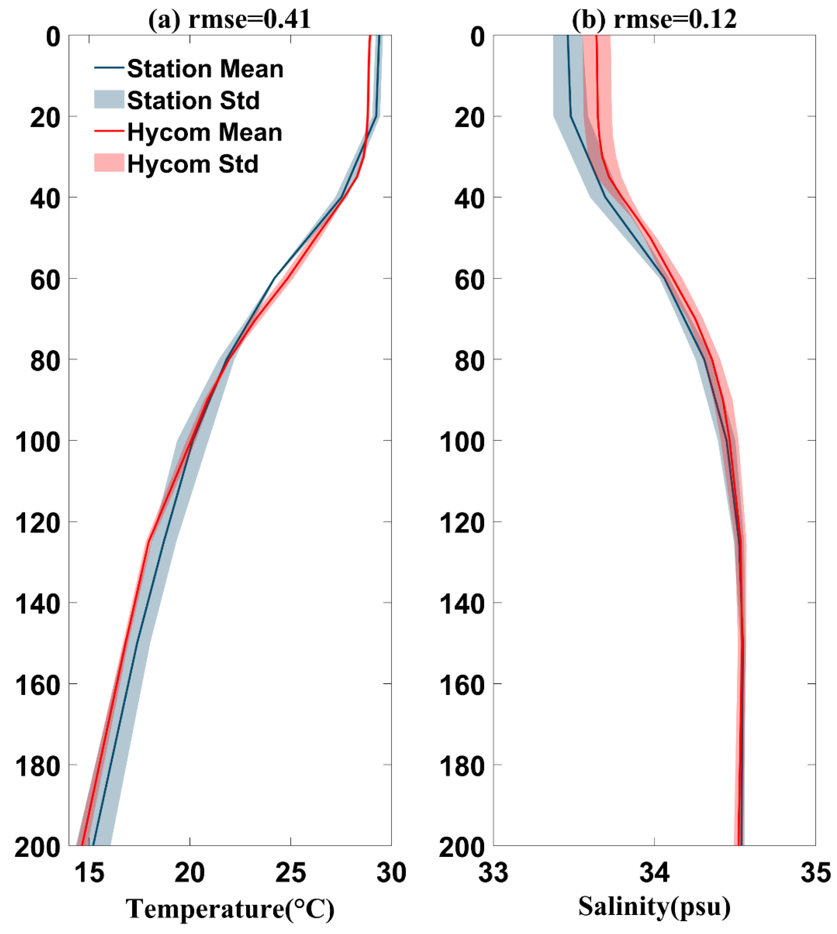
Figure 1. Evaluation of Hybrid Coordinate Ocean Model (HYCOM) data performance during September 2014. Comparison of vertical monthly mean (a) temperature and (b) salinity profile between HYCOM data and Station 2, Station 4, and Station 5.
Remotesensing 16 03293 g001
Figure 3. The daily SST distribution in the southwestern SCS during the Kalmaegi period (9–20 September 2014) provided by RSSs. The color shading represents the SST distribution, with black solid lines representing isotherms below 28 °C at 0.5 °C intervals.
Remotesensing 16 03293 g003
Figure 4. Time variation in the latitude profile at 13°N regarding the (a) SST and (b) wind stress curl. Color shading represents (a) temperature values and (b) wind stress curl values. The black solid lines indicate (a) isotherms ranging from 26 °C to 30 °C at 0.5 °C intervals and (b) isolines ranging from −9 × 10⁻⁶ to 9 × 10⁻⁶ N·m−3 at 1 × 10⁻⁶ intervals. (ce) show the wind field distributions before Kalmaegi entered the SCS (10–14 September 2014), at the midpoint of its entry (12:00 on 15 September 2014), and after it left the SCS (17–20 September 2014), respectively. Color shading represents wind speed, black arrows indicate wind direction, black solid lines represent Kalmaegi’s path, and dots represent the typhoon’s position, with the dot color indicating the typhoon’s intensity.
Remotesensing 16 03293 g004
Figure 5. The upwelling distribution in the southwestern SCS: (a) September climatological average from 2000 to 2023; (be) during the period when Typhoon Kalmaegi entered the SCS (14–17 September 2014); and (f) the difference between the average upwelling during the typhoon and the 24-year September climatological average. Color shading indicates upwelling values, and the black arrows represent sea surface wind direction.
Remotesensing 16 03293 g005
Figure 6. The wind speed distribution in the southwestern SCS: (a) September climatological average from 2000 to 2023; (be) during the period when Typhoon Kalmaegi entered the SCS (14–17 September 2014); and (f) the difference between the average wind speed during the typhoon and the 24-year September climatological average. Color shading indicates wind speed values, and the black arrows represent sea surface wind direction.
Remotesensing 16 03293 g006
Figure 7. Temperature (a,b) and salinity (d,e) profile distributions and their changes (c,f) along 11°N before (12 September 2014) and after (17 September 2014) Typhoon Kalmaegi entered the SCS. Color shading indicates temperature and salinity values. In (a,b), black solid lines represent isotherms from 14 °C to 30 °C at 0.5 °C intervals; in (c), isolines from −4.5 °C to 4.5 °C at 0.5 °C intervals; in (d,e), isolines from 32 to 35 psu at 0.1 psu intervals; and, in (f), isolines from −1 to 1 psu at 0.1 psu intervals. In (e), white dashed lines represent isolines of salinity changes greater than 0.2 psu at 0.1 psu intervals.
Remotesensing 16 03293 g007
Figure 8. Daily SLA and sea surface current field distributions during Typhoon Kalmaegi (9–20 September 2014), provided by AVISO. Color shading indicates SLA values, black arrows represent sea surface current directions, yellow solid lines represent sea surface current speed contours, and the black dashed line indicates the location at 11°N latitude.
Remotesensing 16 03293 g008
Figure 9. (a) Three-dimensional temperature distribution off the east coast of Vietnam before Typhoon Kalmaegi entered the SCS (12 September 2014) and (b) during its passage through the SCS (16 September 2014), as well as (c) the difference between the two. Color shading represents temperature values, and the black dashed line indicates the location at 11°N latitude.
Remotesensing 16 03293 g009
Figure 10. (a) Three-dimensional salinity distribution off the east coast of Vietnam before Typhoon Kalmaegi entered the SCS (12 September 2014) and (b) during its passage through the SCS (16 September 2014), as well as (c) the difference between the two. Color shading represents salinity values, and the black dashed line indicates the location at 11°N latitude.
Remotesensing 16 03293 g010
Figure 11. From 2000 to 2023, monthly averages of (ad) SST and (fi) SLA, including sea surface current distributions off the east coast of Vietnam from June to September, as well as the mean (e) SST and (j) SLA distributions during Typhoon Kalmaegi (14–16 September 2014). In (ae), color shading represents SST values, with black solid lines indicating the 28 °C isotherm. In (fj), color shading represents SLA values, with black arrows indicating the direction of sea surface horizontal currents.
Remotesensing 16 03293 g011
Figure 12. From 2000 to 2023, daily variations in the southwestern SCS (108–114°E, 10–14°N) for (a) SST and (b) wind speed average (black solid line), standard deviation (gray shading), 30-day low pass (red solid line), 2014 values (red solid line), and 2014 30-day low pass (yellow solid line). Thin gray vertical lines mark the first day of each month and 15 September.
Remotesensing 16 03293 g012
Table 1. The names, start dates, and end dates of the 20 typhoons that strengthened CFs, and the cooling magnitude in the southwestern South China Sea (SCS; 108°E–114°E, 10°N–14°N) between five days before and after the passage.
NameYearStart DateEnd DateSea Surface Cooling (°C)
Utor20011 July7 July−1.26
Hagupit20029 September15 September−0.68
Imbudo200315 July25 July−0.78
Washi200528 July31 July−0.41
Fengshen200817 June27 June−0.59
Hagupit200817 September25 September−0.80
Molave200915 July19 July−0.77
Goni200931 July9 August−0.50
Haima201116 June25 June−1.40
Vicente201218 July25 July−0.85
Cimaron201314 July19 July−0.96
Rammasun201410 July19 July−0.48
Kalmaegi201410 September17 September−0.64
Sonca201721 July29 July−0.45
Maria20183 July13 July−1.50
Wipha201930 July3 August−0.83
Podul201925 August30 August−0.46
Cempaka202117 July24 July−1.22
Talim202313 July18 July−0.78
Doksuri202320 July31 July−0.81
Disclaimer/Publisher’s Note: The statements, opinions and data contained in all publications are solely those of the individual author(s) and contributor(s) and not of MDPI and/or the editor(s). MDPI and/or the editor(s) disclaim responsibility for any injury to people or property resulting from any ideas, methods, instructions or products referred to in the content.