Article

Tracking Forest Disturbance in Northeast China’s Cold-Temperate Forests Using a Temporal Sequence of Landsat Data

1
Beijing Key Laboratory of Precision Forestry, College of Forestry, Beijing Forestry University, Beijing 100083, China
2
Key Laboratory of Forest Cultivation and Protection, Ministry of Education, Beijing Forestry University, Beijing 100083, China
3
National Engineering Laboratory for Satellite Remote Sensing Applications, Aerospace Information Research Institute, Chinese Academy of Sciences, Beijing 100094, China
4
Institute of Geographical Sciences, Henan Academy of Sciences, Zhengzhou 450052, China
5
Key Laboratory of Remote Sensing and Geographic Information Systems in Henan Province, Zhengzhou 450052, China
6
Henan Provincial Forestry Ecological Construction and Development Center, Zhengzhou 450003, China
*
Author to whom correspondence should be addressed.
These authors contributed equally to this work.
Remote Sens. 2024, 16(17), 3238; https://doi.org/10.3390/rs16173238
Submission received: 25 July 2024 / Revised: 21 August 2024 / Accepted: 30 August 2024 / Published: 1 September 2024

Abstract

:
Cold-temperate forests (CTFs) are not only an important source of wood but also provide significant carbon storage in China. However, under the increasing pressure of human activities and climate change, CTFs are experiencing severe disturbances, such as logging, fires, and pest infestations, leading to evident degradation trends. Though these disturbances impact both regional and global carbon budgets and their assessments, the disturbance patterns in CTFs in northern China remain poorly understood. In this paper, the Genhe forest area, which is a typical CTF region located in the Inner Mongolia Autonomous Region, Northeast China (with an area of about 2.001 × 10⁴ km2), was selected as the study area. Based on Landsat historical archived data on the Google Earth Engine (GEE) platform, we used the continuous change detection and classification (CCDC) algorithm and considered seasonal features to detect forest disturbances over nearly 30 years. First, we created six inter-annual time series seasonal vegetation index datasets to map forest coverage using the maximum between-class variance algorithm (OTSU). Second, we used the CCDC algorithm to extract disturbance information. Finally, by using the ECMWF climate reanalysis dataset, MODIS C6, the snow phenology dataset, and forestry department records, we evaluated how disturbances relate to climate and human activities. The results showed that the disturbance map generated using summer (June–August) imagery and the enhanced vegetation index (EVI) had the highest overall accuracy (88%). Forests have been disturbed to the extent of 12.65% (2137.31 km2) over the last 30 years, and the disturbed area generally showed a trend toward reduction, especially after commercial logging activities were banned in 2015. However, there was an unusual increase in the number of disturbed areas in 2002 and 2003 due to large fires. The monitoring of potential widespread forest disturbance due to extreme drought and fire events in the context of climate change should be strengthened in the future, and preventive and salvage measures should be taken in a timely manner. Our results demonstrate that CTF disturbance can be robustly mapped by using the CCDC algorithm based on Landsat time series seasonal imagery in areas with complex meteorological conditions and spatial heterogeneity, which is essential for understanding forest change processes.

1. Introduction

Forests, which constitute the predominant terrestrial ecosystems on Earth, are responsible for storing 77% of the carbon present within terrestrial vegetation [1]. Forests are enormous carbon regulators on Earth due to their vulnerability to natural and human-induced changes [2]. It is common to think of forest disturbances as phenomena that cause an amount of forest cover to decrease significantly or vanish, including abrupt and gradual disturbances [3]. Forest disturbance events encompass a spectrum of factors predominantly comprising anthropogenic activities such as logging, construction activities, and post-deforestation farming alongside natural phenomena such as wildfires, pest infestations, and meteorological hazards. Natural and anthropogenic factors cause differences in the disturbance characteristics of different forest types, and assessing the causes of disturbance helps the adoption of scientific management measures to precisely improve forest quality and carbon sequestration capacity. Forest disturbances can have far-reaching consequences for ecosystem functioning, biodiversity, and ecosystem services [4,5]. According to the latest Intergovernmental Panel on Climate Change assessment, the risk of forest degradation induced by climate change will increase temperature [6]. Therefore, an accurate assessment of the forest changes produced by a disturbance and the exploration of disturbance causes are not only necessary for sustainable forest management but also form an important basis for carbon measurement in the study of the Earth’s carbon cycle [7].
Cold-temperate forests (CTFs) are extensively dispersed and provide a significant wood supply worldwide. CTF biomass accounts for around 14% of total global biomass, which contains enormous potential for ecological development [8]. CTFs develop more slowly than tropical and temperate forests, recover more slowly after degradation or loss, and attract less attention from research and governments [9]. In the context of global climate change and the development of human society and the economy, efficiently capturing information on CTF disturbance can not only help the United Nations (UN) Reducing Emissions from Deforestation and Forest Degradation effort (REDD+) but also provide precise data for regional carbon sink calculations [10].
Traditional approaches to detecting forest disturbance mainly depend on ground-based manual surveys, which have high costs and low efficiency and cannot be carried out on a wide scale [11]. With the continual advancement of remote sensing technology, accessible remote sensing imagery has grown in abundance, demonstrating unrivaled benefits in spatial, spectral, and temporal resolution and can better record forest disturbance occurrences. Due to their most acceptable spatial resolution and longest archived records in natural resource management applications, Landsat series satellite data have increasingly become an essential data source for forest disturbance identification [12]. Meanwhile, Google Earth Engine (GEE) [13], Amazon Web Service (AWS) [14], Microsoft Planetary Computer (MPC), the PIE-Engine [15] platform for Landsat, MODIS, AVHRR, and Sentinel have been rapidly developed, providing users with reliable tools for convenient and efficient on-demand long-term regional forest disturbance detection. Furthermore, forest disturbance detection algorithms based on Landsat time series data have begun to emerge one after the other using the geographic cloud computing service platform and have rapidly developed into the mainstream [16].
Time series change detection involves identifying the true surface change or the change in interest and then assessing the disturbance’s time, intensity, causes, and other characteristics [17]. Landsat time series change detection approaches have been classified into two types: spectral variable-time feature methods and time series trajectory analysis methods [18]. The vegetation change tracking (VCT) model [19] is the most typical of the spectral variable-time feature techniques, and uses the difference in spectral information in the time series before and after the disturbance to detect the changes. In the western United States, most forest disturbances were recognized with an overall accuracy of roughly 80% using the VCT algorithm. The heart of the time series trajectory analysis approach is examining spectral variables’ time series relationships. The commonly used algorithms include the Landsat-based detection of trends in disturbance and recovery (LandTrendr) [20], breaks for additive season and trend (BFAST) [21], continuous change detection and classification (CCDC) [22], vegetation regeneration and disturbance estimates through time (VeRDET) [23], the continuous monitoring of land disturbance (COLD) [24], and continuous change detection and spectral mixture analysis (CCDC-SMA) [25], which was developed based on CCDC. These algorithms have shown positive outcomes in North America, Europe, and West Asia, with total accuracies ranging from 70% to 91%. The abundant historical disturbance data in these places give a significant number of samples for disturbance detection algorithms, providing enough knowledge and data support for empirical threshold setting and algorithm-supervised training [26]. Because of the high demand and general acceptance of time series change monitoring, the CCDC and LandTrendr algorithms have been openly used on GEE [27,28], and these algorithms provide the possibility of studying disturbance in a more extensive region. Among them, the CCDC algorithm shows excellent potential for continuously monitoring land cover status by identifying sudden and gradual changes [24]. Although these studies demonstrate that these disturbance detection algorithms may provide more accurate forest disturbance maps, they rely more on historical disturbance data and have more errors in places with more variability. However, historical statistics on forest disturbance in China are limited due to historical and developmental factors, as is the collection of training samples for damaged forests. At the same time, Landsat is heavily influenced by meteorological conditions, and the quantity of high-quality imagery accessible throughout the year is restricted, complicating disturbance detection algorithms in these areas where cloud, rain, and snow frequently occur in China.
Major CTF habitats in China are found in the Greater Khingan Range but have gradually deteriorated due to the combined effects of commercial logging, fires, pests and diseases, and weather calamities [29]. In the last few decades, more than 40% of CTFs have been logged. Following the eventual cessation of commercial logging, the introduction of the “Natural Forest preservation project” (NFPP) has slowed the rate of CTF degradation [30]. Genhe, Hulunbuir City, Inner Mongolia Autonomous Region, is located on the western slope of the northern part of the Greater Khingan Range. It has the highest forest coverage rate in China and is rich in forest resources. As a typical representative of the CTF region in Northeast China, the Genhe forest area experienced a 63-year logging history (1952–2015), leading to the loss of a massive quantity of forest and the alteration of trees to shrubs and tiny trees in some regions. Furthermore, fires, construction activities, and extreme weather events are the important causes of forest deterioration. Global warming has resulted in the substantial release of CH4 from the permafrost degradation zones in Genhe, thereby amplifying the risk of forest disturbance due to the heightened frequency of wildfires [31]. However, we still lack credible information about CTF disturbances in Genhe and have not assessed which climate or anthropogenic factors play a greater role in the impact of influencing disturbances, making it impossible to scientifically balance the relationship between forest management and conservation in the context of climate change. The CTF ecosystem has been severely damaged in recent decades as a result of the combined effects of commercial logging, fire, and permafrost degradation caused by climate change, but research on disturbance is limited. It is essential and timely to conduct forest disturbance monitoring of the CTF region in Northeast China.
Therefore, with the help of the GEE platform, our research aims to propose a CCDC algorithm that considers seasonal features based on long time series Landsat data to explore the spatial and temporal distribution of disturbances in CTFs and analyze the influencing factors of disturbances. Due to the weak availability of imagery due to the long snow period, some inter-annual seasonal long time series vegetation index datasets were constructed based on limited Landsat imagery during the seasons with less snowfall, and forest cover maps were extracted using the OTSU algorithm. Then, based on the forest cover maps and inter-annual seasonal vegetation index datasets, the CCDC algorithm was employed to capture forest disturbance information in Genhe, a typical region of CTF in Northeast China. Finally, the pattern of disturbance occurrence was analyzed, and the correlation between forest disturbance and influencing factors was assessed. This can provide a scientific foundation for understanding the evolution pattern of CTFs, developing forest management policies, and accurately assessing the capacity of carbon sequestration.

2. Materials and Methods

2.1. Study Area

As the core area of the ecological function of the state-owned forest region in Northeast China, Genhe is located on the western slope of the northern section of the Greater Khingan Range (120°12′–122°55′E, 50°20′–52°30′N), with a total area of 2.001 × 10⁴ km2 (Figure 1). The elevation ranges from 700 to 1300 m, with significant topographical variations and strong erosion effects. The study area has a well-developed river network, primarily consisting of two major river systems: the Gen River and Jiliu River, with more than 470 rivers in total. The climate is cold-temperate and humid, with features of a continental monsoon climate. It is dry and windy during spring, cool and short in summer, has rapid temperature drops in autumn, and the winter is long and cold [32]. The daily average temperature is −5.3 °C, and the extreme minimum temperature is −58 °C. The study area has diverse land surface covers, including woods, meadows, marshes, water bodies, artificial surfaces, bare terrain, glaciers, and permanent snow. The main forest types include coniferous forest—composed of Larixgmelinii (Rupr.) Kuzen. and Pinus sylvestris var. mongholica Litv.—and deciduous broad-leaved forest dominated by Betula platyphylla Suk. and Populus L. [33].

2.2. Data and Preprocessing

Our research employed Landsat imagery, MODIS C6, the ECMWF dataset, the snow cover phenology dataset [34], Openstreet map, the Genhe Chronicle [35,36], and recorded information from the Genhe Forestry Bureau (Table 1).

2.2.1. Landsat Dataset

According to the climate and vegetation phenology of Genhe, and considering the long snow period in autumn and winter, we collected all available Landsat TM, ETM+, and OLI imagery for spring (March–May) and summer (June–August) from 1990 to 2021 and used the Fmask cloud detection algorithm [22] to remove clouds and shadows and the modified normalized water index (MNDWI) to remove water areas. The normalized difference vegetation index (NDVI) [37], enhanced vegetation index (EVI) [38], and ratio vegetation index (RVI) [39] for two seasons were calculated to detect the forest covers and disturbances.
N D V I = p N I R - p R E D p N I R + p R E D
E V I = 2.5 p N I R - p R E D p N I R + 6.0 p R E D - 7.5 p B L U E + 1
R V I = p N I R p R E D
The yearly imagery was divided into two seasonal imagery sets (Spring and Summer), then six (Spring & NDVI, Summer & NDVI, Spring & EVI, Summer & EVI, Spring & RVI, Summer & RVI) inter-annual seasonal vegetation index time series datasets were constructed for extracting forest cover regions and identifying forest disturbances. The spatial resolution of these datasets was 30 m.

2.2.2. Road and River Vector Dataset

The vector data of roads and waterways in Genhe were obtained through the Openstreet map platform.

2.2.3. Dataset of Factors Influencing Forest Disturbance

(1) The ECMWF from 1991 to 2020 and MODIS C6 from 2000 to 2020 were collected to obtain the annual total precipitation, average temperature, and number of fires in Genhe using the Band math tool.
(2) We extracted the total number of snow cover days each year in Genhe from 1991 to 2020 based on the dataset of snow phenology in China.
(3) Annual commercial timber production, large fire incidents, and burned areas were counted from 1990 to 2020 using the Genhe Chronicle and recorded information from the Genhe Forestry Bureau.
All the above operations were carried out using ArcGIS 10.8, and all the above results were exported to Excel.

2.3. Research Method

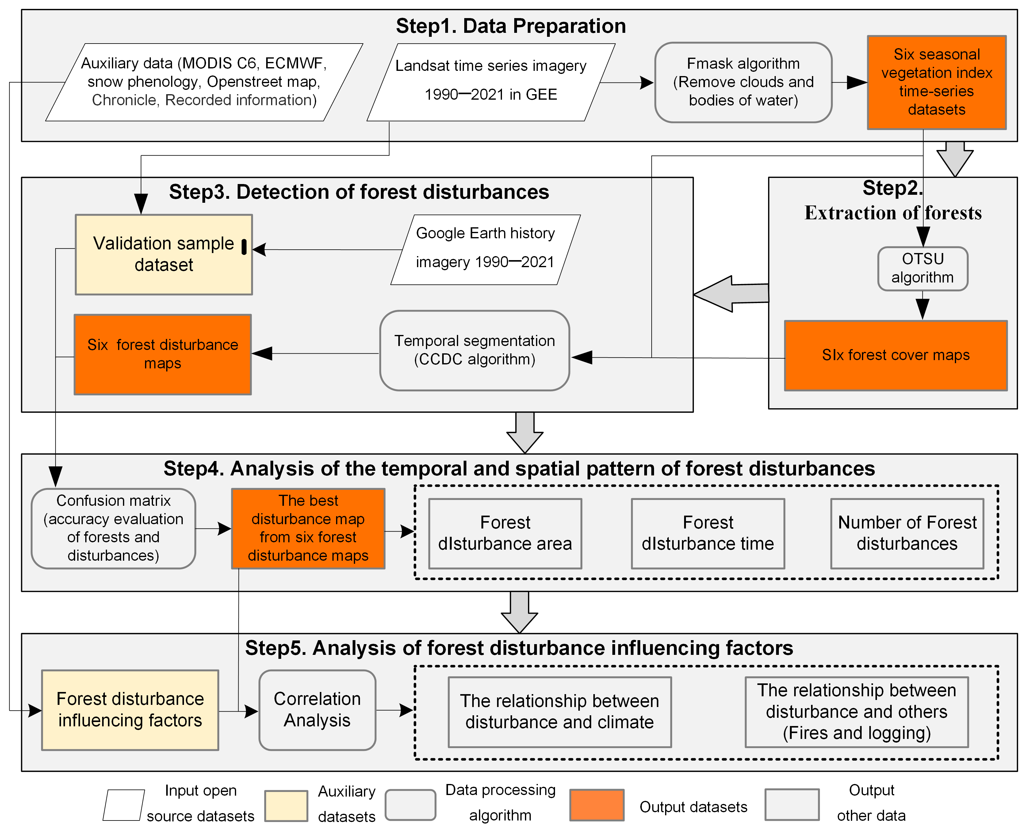
The forest disturbance detection and mapping procedure included five major steps (Figure 2). First, six inter-annual seasonal vegetation index time series datasets were created using Landsat imagery. In step 2, based on the datasets from step 1, an efficient binarization algorithm (OTSU) was applied to segment the annual forest/nonforest information, and then a maximum value composite method was used to obtain six forest cover maps for the period from 1990 to 2021. Third, the CCDC algorithm was introduced to detect disturbances and extract six forest disturbance maps based on the datasets in step 1 and step 2. Next, the accuracy of the forest disturbance maps was evaluated in order to determine the final disturbance map with the best accuracy, and the spatial and temporal distribution patterns and the number of disturbances were analyzed. Finally, the detected area of disturbance was compared with auxiliary data, such as the climate, fires, and commercial logging, to assess the factors influencing the area of disturbance. Steps 1–3 were conducted on GEE, step 4 used Arcgis10.8, and step 5 was carried out using R.

2.3.1. Mapping of the Forest

The OTSU method, introduced by Japanese scholar Otsu in 1979, is an algorithm used to determine the optimal threshold for image binarization. The core idea of the OTSU algorithm is to maximize the between-class variance when dividing the original image into two parts: foreground and background. The greater the variance between these classes, the lower the likelihood of mis-segmentation. The core advantage of this algorithm is that it is computationally simple and fast and is the best algorithm for threshold selection in image segmentation, which has been widely used in digital image processing [40].
Therefore, we chose the OTSU algorithm to segment the above six inter-annual seasonal vegetation index time series datasets separately, calculated the thresholds for segmenting forest and nonforest, extracted the forest information for each year, and performed the maximum synthesis to obtain six forest cover maps from 1990 to 2021.

2.3.2. Detection of Forest Disturbance

At present, there are many disturbance detection algorithms; LandTrendr and CCDC are widely used. Among them, the CCDC algorithm is a time series-based change detection algorithm that was proposed by Zhu and Woodcock [22] and uses all available Landsat data to model temporal and spectral features, including seasonality, trend, and variability. The CCDC algorithm can segment the time series data of pixels and divide the whole time series into several sub-time series, and each sub-time series corresponds to a time series model. Based on these time series, the number and length of line segments (in years), the slope, and the year corresponding to the vertex can be derived [22].
We selected the CCDC algorithm on the GEE platform to complete the extraction of forest disturbance areas. The CCDC algorithm requires the adjustment of numerous parameters. We visualized the parameter range by visually evaluating 50 sample locations of known disturbances in the research region.
The best combination of parameters for the CCDC algorithm (Table 2) was determined after evaluating the consistency of the trajectory with reality for multiple samples under different parameter combinations. Six forest disturbance maps were output based on the six inter-annual seasonal vegetation index time series datasets obtained in Section 2.2 and the six forest cover maps extracted in Section 2.3.1. Because disturbance detections for the beginning and end years of a time series are frequently incorrect, the disturbance maps excluded 1990 and 2021.

2.3.3. Accuracy Evaluation of the Temporal and Spatial Distribution of Forests and Disturbances

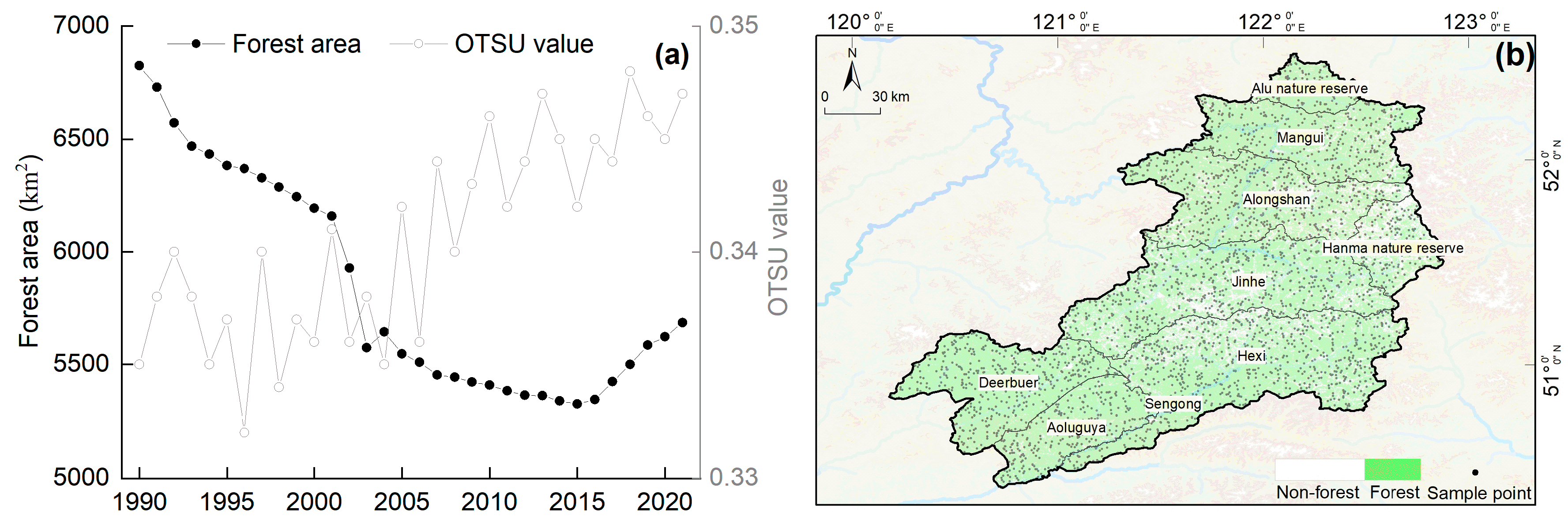
In order to correctly evaluate the accuracy of forest cover maps, a random sampling method was used to select 3000 validation samples in Genhe (Figure 3b). For each sample, we verified whether each sample had forest cover during the study period from high-resolution historical imagery and time series Landsat imagery from Google Earth. In order to assess the accuracy of forest disturbance maps, we took the same approach to select 3000 validation samples in the forest cover area (Figure 3b), deciphering whether disturbance occurred in each sample during the year. This sample set was used to evaluate the accuracy of six forest cover maps and disturbance maps using the confusion matrix.
By assuming 1 as the positive sample and 0 as the negative sample, the metrics in the confusion matrix are defined as follows:
True positive (TP): The number of positive samples correctly predicted by the classification model. False negative (FN): The number of positive samples incorrectly predicted as negative by the classification model. False positive (FP): The number of negative samples incorrectly predicted as positive by the classification model. True negative (TN): The number of negative samples correctly predicted by the classification model.
We used overall accuracy (OA), user accuracy (UA), and producer accuracy (PA) to evaluate the accuracy using the following specific formulas:
O A = ( T P + T N ) 100 % / ( T P + T N + F P + F N )
U A = T P 100 % / ( T P + F P )
P A = T P 100 % / ( T P + F N )

2.3.4. Analysis of the Temporal and Spatial Pattern of Forest Disturbances

We chose the result from the seasonal imagery and vegetation index combinations in Section 2.3.3 with the highest accuracy to produce a forest disturbance map from 1991 to 2020, which was then used for a spatial and temporal pattern analysis of disturbance.
In order to describe the characteristics of forest disturbance, we chose the following indicators:
(1) The year with the largest disturbance amplitude during the detection period was defined as the time at which the most significant change in the amplitude occurs in the given date range and spectral band.
(2) The number of disturbances was defined as the total number of detected disturbances in the specified period.
As a result, the disturbance map diagram comprised two bands: maximum disturbance year and number of disturbances.
With the help of MODIS C6 and Landsat historical imagery, we determined the burning historical area from 1991 to 2020, and after overlaying this with the disturbance map, we obtained a disturbance map excluding disturbance patches caused by fire.
The accessibility of roads determines the difficulty of commercial logging and transportation, and rivers also provide a secondary means of transport for wood transfer from inaccessible areas. Both influence the distribution of logging areas. We performed a buffer analysis for different levels of roads (provincial roads, county roads, and township roads) and rivers (rivers and streams) from the Openstreet map platform with buffer spacings of [0, 0.2), [0.2, 0.4), [0.4, 0.6), [0.6, 0.8), [0.8, 1), [1, 2), [2, 3), [3, 4), [4, 5), [5, +∞), and the buffer distance units are in km. All buffers were overlaid with the disturbance patches except for the patches caused by fires to count the area of disturbance occurring at different distance ranges for roads and rivers and to analyze the relationship of the disturbance to roads and rivers. The above operations were implemented in ArcGIS 10.8.

2.3.5. Analysis of Forest Disturbance Influencing Factors

Sudden forest disturbance events produced by fire and commercial logging are the most common forms of CTF in Northeast China [41].
(1) Step 1: In order to evaluate the factors influencing forest disturbances, we analyzed the relationships between temperature, precipitation, snow cover days, the number of fire occurrences, commercial logging, and disturbance area, taking into account the natural environment and policy context of Genhe by using the data presented in Section 2.2.
(2) Step 2: Since the commercial logging activities in Genhe were minimal after 2010 and completely banned by 2015, the contribution of natural disturbance factors induced by climate change to forest disturbances became more significant as commercial logging gradually ceased. Therefore, to eliminate the interference of commercial logging as a factor, we selected the data on temperature, precipitation, snow cover days, the number of fire occurrences, and disturbance area from 2011 to 2020 for correlation analysis.
(3) Step 3: In order to exclude disturbances caused by fire, we repeated the analysis from Step 1, with the disturbance area excluding fire-induced disturbance events.
(4) Step 4: In order to further verify the relationship between fire and forest disturbances, we conducted a correlation analysis between the burned area and forest disturbance area. Additionally, we extracted forest disturbance data for the pixels where fires occurred and cross-referenced the locations and times of the fire occurrences with the disturbance events.
It is important to note that due to the prolonged periods of low temperatures each year in Genhe, forest pests and diseases do occur but have not yet spread on a large scale. Given the lack of valid records on the occurrence of pests and diseases, these factors were not included in the analysis of influencing factors.

3. Results

3.1. Accuracy of Forest Cover Synthesis Maps and Forest Disturbance Maps

We used the OTSU algorithm to calculate the thresholds for segmenting forest and nonforest (Figure 3a) and then performed the maximum synthesis to create six forest cover maps (Figure 3b).
We verified the accuracy of six forest cover maps from 1990 to 2021 (Table 3). The total accuracy was higher than 85%, among which the accuracy of the forest cover map obtained by using binary segmentation using the EVI of summer imagery only was the highest (93.80%), meaning this result could meet the needs of the research.
We created six disturbance maps based on random combinations of seasonal imagery (Spring and Summer) and vegetation indices (NDVI, EVI, and RVI), all with moderate-to-high accuracy (Table 4). The total accuracy of specific indices and seasons ranges from 74.23% (Spring & NDVI) to 88% (Summer & EVI), with an average accuracy of 81.63% (Table 4). The EVI-based disturbance map has the highest accuracy, while the NDVI-based disturbance map has the lowest accuracy. There is also a definite seasonal pattern independent of the index, which is the accuracy from June to August being more precise than those from other periods. As a result, we chose the combination with the highest accuracy (Summer & EVI) to generate the final forest disturbance map.
With the help of Google Earth historical imagery and Landsat imagery, during the disturbance accuracy verification process, we found that 950 sample points experienced a single disturbance caused by logging, anthropogenic fires, or wildfires (Figure 4a,b). Additionally, 270 sample points experienced multiple disturbances due to wildfires (Figure 4c), and 130 sample points encountered multiple disturbances resulting from a combination of logging, anthropogenic fires, and wildfires (Figure 4d).

3.2. Occurrence Pattern of Forest Disturbance

3.2.1. Spatial and Temporal Distribution of Forest Disturbance

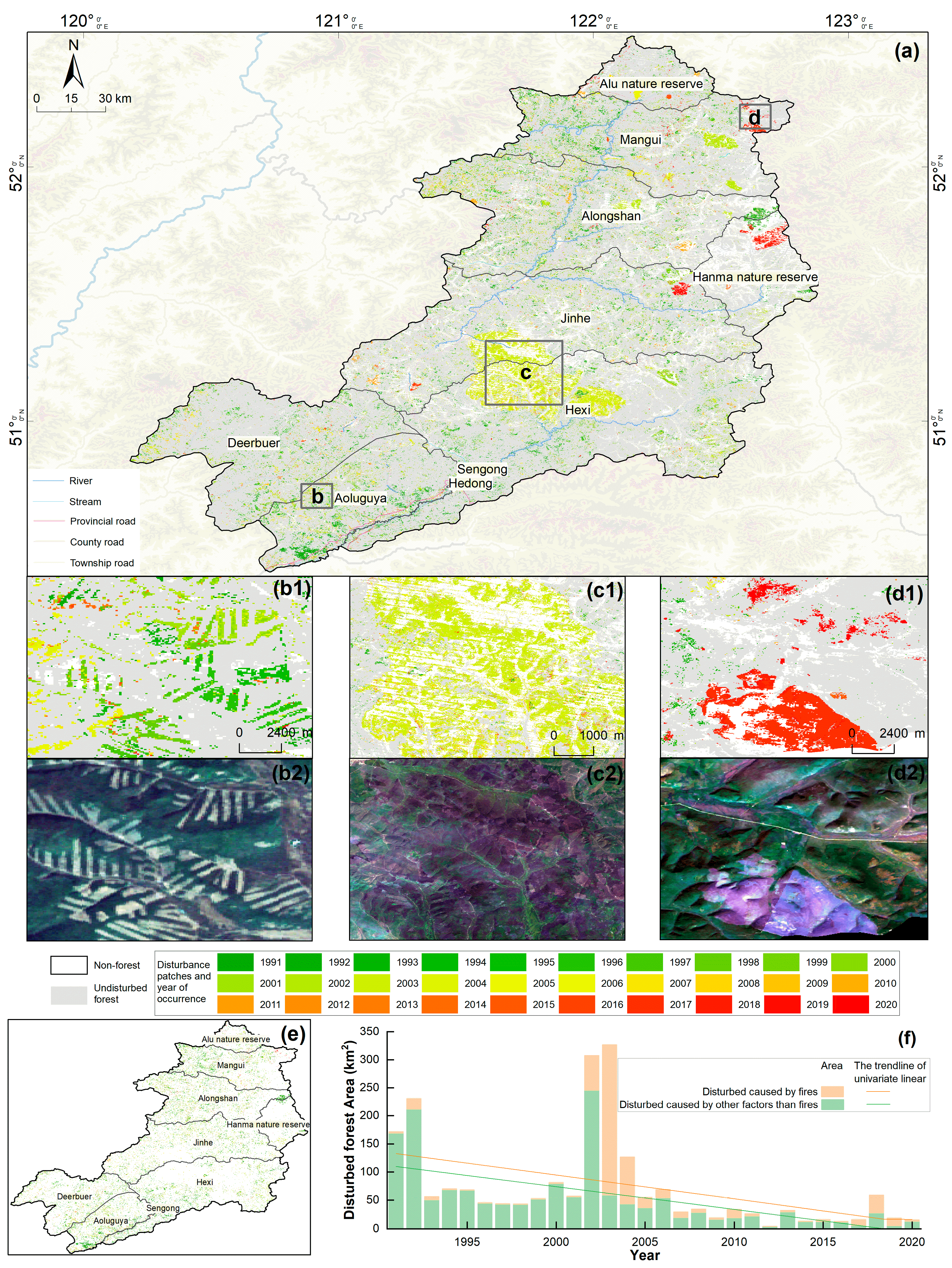
The forest disturbance map (Figure 5) in Genhe exhibited spatial and temporal patterns. From 1991 to 2020, the total area of disturbed forest was 2137.31 km2, accounting for 12.65% of the total forest area, and the average annual rate of forest disturbance was 1.18%.
Most of these disturbances were located at the edges of larger forest patches and within forest patches close to roads and major rivers (Figure 5a). However, the extensive surviving forest in distant locations tended to be less disturbed, particularly in the study area’s northeast (Alu and Hanma Nature Reserve) and southwest (Deerbuer town). The disturbance rates, i.e., the percentage of the total disturbed area to the forest area in the administrative area of the study cycle, were highest in Hedong and Hexi streets (33.18% and 15.64%), while the lowest rates were found near to Alu and Hanma Nature Reserve (9.96% and 9.71%). In addition, the disturbance patterns ranged from relatively regular patches (Figure 5b) to larger continuous patches (Figure 5c) and to a more scattered and irregular pattern lastly (Figure 5d), all indicating different disturbance causes.
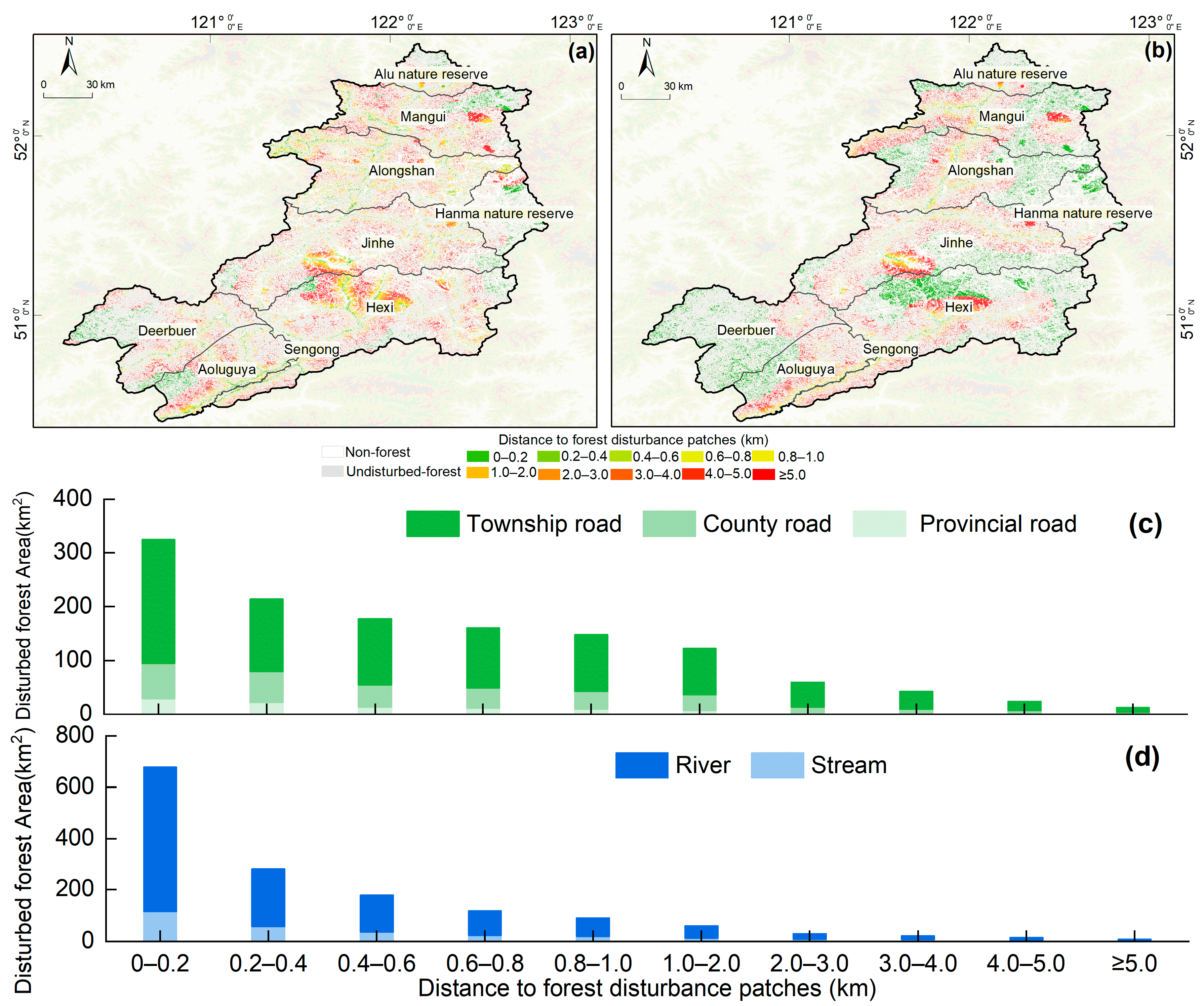
The distribution of forest disturbances is more directly affected by the distance from roads and rivers (Figure 6). Overall, the disturbance area on both sides of highways and waterways diminished with the distance increasing. The disturbance distribution on both sides of provincial and county roads was lower, while the disturbance area on both sides of township roads was more significant (Figure 6a,c). The main reason is that the primary logging roads are low-grade township roads that reach deep into the forest, whereas the provincial and county roads serve as the outgoing channel for timber. The relatively dense distribution of disturbance on the sides of larger rivers and the lesser distribution of disturbance around smaller streams (Figure 6b,d) is related to the difference in the carrying capacity of the rivers. The larger the river, the greater the carrying capacity and the easier it is to transport wood.
Forest disturbance has tended to strengthen and then weaken over the last 30 years, but the magnitude of change has been variable (Figure 5f). The disturbance of large continuous patches primarily occurred in the beginning and middle of the research period, particularly in 1992, 2002, and 2003, when the disturbance area all surpassed 200 km2, reaching a high value of 326.68 km2 in 2003. Several large, contiguous patches in Hexi Street and Jinhe Town are highly representative, and these patches are mostly located on both sides of the roads. The disturbance area was reduced after 2008, and the disturbance rate was less than 1% in each year. The disturbance area in 2012 was the smallest (4.64 km2). Recently, disturbed patches have commonly become more dispersed, and the geometry of the patches was more variable. This is mainly due to the significant reduction in incidents of human disturbance since commercial logging was gradually banned, and disturbed patches caused by wildfires were more prominent (Figure 5d,e).

3.2.2. Number of Forest Disturbance Events

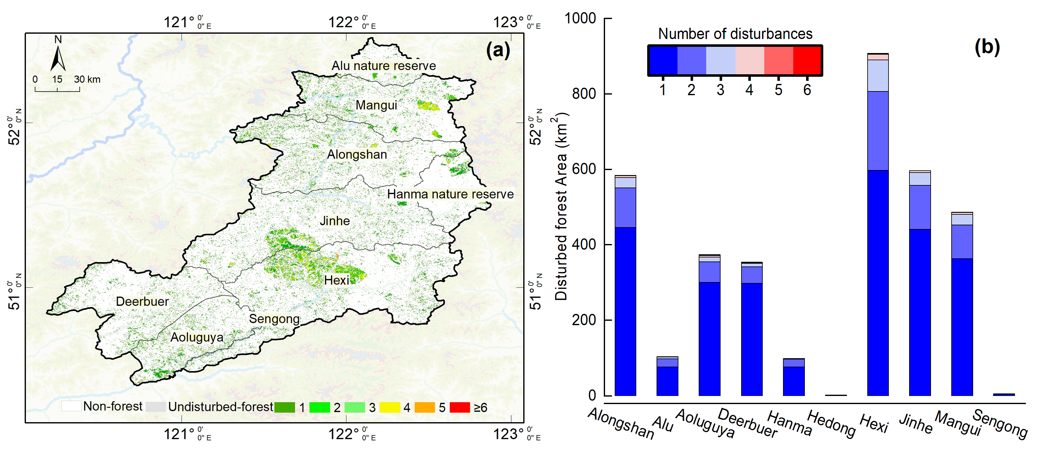
Disturbance events were widely distributed in the forests of Genhe, with a strong spatial heterogeneity in the overall distribution of disturbance counts (Figure 7a). The forest area disturbed once, twice, three times, or more than four times accounted for 15.40%, 3.92%, 1.20%, and 0.27% of the total, respectively (Figure 7b).
Typically, fires and commercial logging are regarded as abrupt disturbance events, whereas other types (pest, disease, frost, drought, etc.) are gradual. In the study area, abrupt disturbance events were widely distributed, with the majority having only one disturbance, and some areas distributed in clusters experiencing multiple abrupt disturbances (e.g., at the junction of Jinhe Town and Hexi Street), where the super-imposed effects of fire and commercial logging resulted in unusually dramatic vegetation changes. In contrast, gradual disturbance events are less frequent, scattered near major rivers and roads, and vegetation changes are less distinctive and difficult to capture.
Disturbance events were dominated by abrupt disturbance in all administrative districts, with the proportion of abrupt disturbance to the total disturbed area in the district varying, but all exceeded 83%. Hanma Nature Reserve, Deerbuer Town, and Alu Nature Reserve had the highest proportion of abrupt disturbances (97%, 94%, and 92%), and these areas were less populated and had less human activity. In contrast, Hedong, Hexi, and Sengong Street were the administrative districts with the highest proportion of areas under gradual disturbance (27% and 25%), and these areas were widely spread with residential areas and high human activity.

3.3. Influencing Factor of Forest Disturbance

3.3.1. Climate Factors

The linear regression models showed that the correlation between disturbed area and precipitation (Figure 8a1), temperature (Figure 8b1), and snow cover days (Figure 8c1) was low from 1991 to 2020 (R2 ≤ 0.2). Compared to the entire study period, the correlation between precipitation (Figure 8a2), temperature (Figure 8b2), snow days (Figure 8c2), and forest disturbance area all increased during the period from 2011 to 2020, following the cessation of commercial logging (R2 ≤ 0.49). Notably, the correlation between precipitation and disturbances showed a significant increase (Figure 8a2). Among the climatic factors, the correlations between precipitation and snow days and disturbance were slightly higher than that of temperature, which indicates that precipitation and snow are more closely related to disturbance in the CTF, but this still does not fully explain the area of disturbance. The interactions between the three climate factors also reduce their ability to explain disturbance.
Although there was no correlation between annual mean temperature and forest disturbances (Figure 8b1, 8b2, 8b3), the correlation between fire and forest disturbances was relatively high (Figure 8d1). In Genhe, the occurrence of forest fires is influenced by a combination of factors, including available fuel, ignition sources, and extreme drought events. Since annual mean temperature does not capture the occurrence of extreme drought events, this lack of correlation is reasonable.

3.3.2. Commercial Logging and Fires

Linear regression models demonstrate that both commercial logging and fires were strongly associated with forest disturbance from 1991 to 2020.
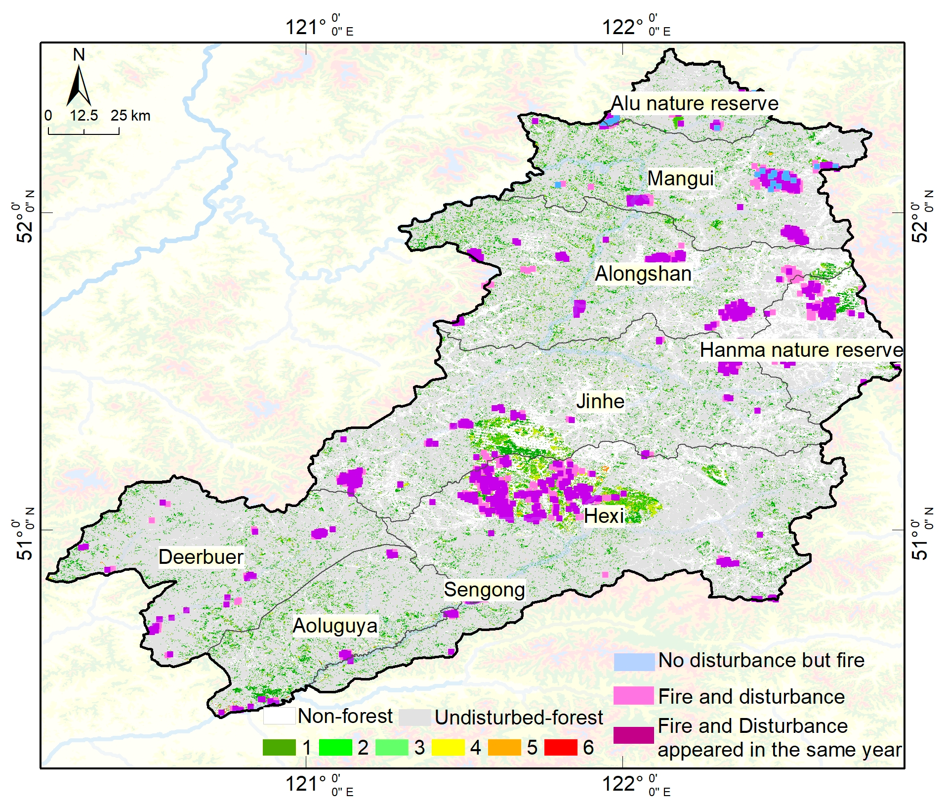
From 2001 to 2020, the number of fires was closely related to forest disturbance (R2 = 0.75) (Figure 8d1). The correlation was even stronger during the period from 2011 to 2020 (R2 = 0.81) (Figure 8d2). The distribution of fire occurrences exhibited very high spatial heterogeneity. Additionally, the correlation between burned area and disturbance area was significant (R2 = 0.70) (Figure 8d3), indicating that fire is a major factor exacerbating disturbances. We found that the disturbance event occurrence rate in pixels with fire occurrences reached 82.16%, and the proportion of records where fire and disturbance both occurred within the same year was 68% (Figure 9), demonstrating strong synchronicity and further confirming that fire events are a primary factor influencing forest disturbances.
There is a degree of correlation between commercially logged timber production and disturbance (R2 ≤ 0.57) (Figure 8e3). Affected by the logging quota system introduced in 1986, commercial logging had declined year after year, tending to coincide with the downward trend in the area of disturbance. The correlation between commercial logging and disturbed area was influenced by the lag effect between them.
The two years with a high number of fires (2002 and 2003) were neither dry nor warm or snow-free, but the area of disturbance was unusually high, and verification revealed that anthropogenic fires had occurred in both years. Overall, the relationship between forest disturbance and fires was closer than climate factors. During the active period of commercial logging, disturbance was more strongly correlated with commercial logging and fire. With the gradual ban on commercial logging, the disturbance of forests by fire has been further exacerbated.

4. Discussion

4.1. Extraction of Forest Disturbance Information

The OTSU algorithm has been widely used in the field of remote sensing image processing and analysis because of its high segmentation efficiency and wide applicability, but few results have been reported on the applications of mapping forests [42]. In our study, the OTSU algorithm was used to map the forest with good results, showing its potential for forestry applications.
Zhu and Woodcock [43] developed the CCDC algorithm and conducted small-range disturbance detection tests with an overall accuracy of 91.80%. Researchers have developed disturbance detection algorithms, such as COLD, S-CCD, and CCDC-SMA, based on the CCDC algorithm, with overall accuracies ranging from 79% to 91% [24,25,44]. The higher accuracy of these studies was based on remote sensing imagery during all periods, and the amount of data required was large. We achieved regional forest disturbance mapping based on seasonal long time-series Landsat imagery with an overall accuracy of 87.16%, which was slightly lower than the previous studies. This might be due to the strong availability of imagery in the aforementioned study area; Genhe was affected by meteorological conditions, and the imagery had more clouds; we performed the process of eliminating clouds as soon as possible but still could not avoid the influence of image quality on the extraction of disturbance information. Combined with the climatic conditions in Genhe, our study used only seasonal (summer) imagery and the EVI index, which reduced the amount of data input and improved the applicability of the CCDC algorithm in areas with high cloudiness without significantly reducing accuracy. However, whether the seasonal and spectral indicators chosen in this study work better in other locations requires additional investigation. A growing number of studies have shown that the transferability of a single-detection algorithm is unstable, and it is still a challenge to improve this [45,46,47].
Regarding the effectiveness of a single index in the disturbance detection of CTF, we found that EVI has very good potential. Sha (2020) identified that NBR performed best, whereas other studies discovered that the combination of brightness, greenness, and humidity was better [10]. The diversity of feature indices may be related to the different disturbance characteristics of each research region. It is necessary to further explore the development of integrated approaches using multi-feature combinations in depth so as to avoid the constraints caused by differences in regional disturbance characteristics on the robustness of the methods as much as possible.

4.2. Characteristics of Forest Disturbance

The forest area in Genhe has been diminishing and then expanding over the last 30 years (Figure 3), whereas the disturbed area has varied and declined (Figure 4e). The synchronization between the disturbed area dynamics and the forest area changes was weak, which may be due to policy issues such as afforestation, tending, etc. [48]. Although the forest disturbance rate has shown a fluctuating downward trend in each administrative zone, the magnitude of the decrease differed. It is worth mentioning that there was a significant change in the disturbance rate of the natural reserves (Alu and Hanma) before and after their establishment, with the magnitude of disturbance significantly diminished after their establishment, and the protective effect was outstanding. In addition to disturbance events caused by fires, disturbances were mostly distributed around roads and rivers in areas where commercial logging frequently occurred. Generally, the closer the distance to roads and rivers, the more frequent the disturbance occurs, and this phenomenon is common [49]. However, the disturbance area at a distance of more than 5 km from the river and road is larger than those areas that are less than 5 km in Genhe (Figure 5). This might be due to the fact that the fire is likely to spread far. At greater distances from rivers and roads, fires cause a greater area of disturbance because fire suppression measures cannot be taken for a short period of time. In the case of windy weather, fires spread faster and burn over a larger area [50].
Disturbance occurred regularly in the forests of Genhe. It is worth mentioning that 29.67% of disturbance events were concentrated in 2002 and 2003, mainly caused by anthropogenic fires. This proves that the unusual weather and fire events in these two years had intensified forest disturbance in Genhe.

4.3. Categorizing Factors Influencing Forest Disturbance

There are several elements that influence forest disturbance. Fire and drought are the most prevalent elements influencing worldwide forest disturbance. Generally, high-risk fires usually follow more drought, so drought is an enabler of fire outbreaks and their spread [51]. Forest fires happened in many places around the world due to unusually dry and hot weather and strong winds in 2003 [52]. In the same year, the average temperature was 1.38 °C higher than the national average in Genhe, so the forests burned by the anthropogenic fires may have been under drought stress before the fire occurred. Extreme weather events, such as drought and freezing damage, are becoming more frequent under global climate change, and the unpredictability of these occurrences on forest stress will rise in Genhe, making it more vital to assess the disturbance status regularly [53].
In order to understand the process of gradual forest change, the accurate detection of disturbance and the analysis of attribution are necessary [54]. We can distinguish between the causes of disturbance by extracting fire trails and logging trails and focusing on the rapid changes in the forest. Although we did not distinguish disturbance factors, both the shape of the disturbance patches and the time series imagery suggest the disturbance process. We discovered several large contiguous areas of disturbed forest (Figure 4b), typically located near roads and rivers, and these have resulted from commercial logging. Depending on accessibility and soil type, some logging sites were transformed into farmland or natural restoration areas. Due to the lack of reasonable planning of logging areas and scientific logging limits in the 1990s, there were many unlicensed loggings in addition to approved legal logging, which were generally concentrated near highways for convenient mechanized cutting and timber transportation, and the disturbed patches were big and spread out in a line. Irregular and continuous disturbed patches (Figure 4c) were caused by fires, and these areas were often found in regions with relatively gentle terrain and away from fire breaks such as roads and rivers, which indicated that fires spread rapidly to nearby forests after a mountain fire, with the wind taking advantage of the terrain. The representative event shows the near destruction of contiguous forests due to a border-crossing fire, which occurred on 5 May 2003, followed by forest regeneration (Figure 4c). In addition to these larger disturbance patches, there are many disturbance events that appear to be associated with wildfires in clusters (Figure 4d). There are many dead, diseased, rotten, and old trees in the forest of Genhe, and the surface is rich in dead and fallen materials with a deep humus layer. At the same time, Genhe belongs to the permafrost area, which stores high concentrations of high-pressure CH4 underground [31]. In the spring of each year, as the frozen layer of the ground thaws and the snow gradually melts, CH4 moves rapidly upward to be released into the atmosphere and rubs against shallow soil particles, water vapor, and forest litter, resulting in the discharge of positively charged CH4 against negatively charged materials such as soil and humus. In addition, as the thawing of the permafrost intensifies, the further release of CH4 from the air and gradual accumulation of positive charges enhances the discharge phenomenon and ignites higher concentrations of CH4 and forest combustibles near the ground surface. More serious is that once struck by lightning, combustible materials are easily ignited, which can lead not only to a short wildfire but also very easily to multi-point outbreak conditions [55]. Thus, within the context of climate warming, the gradual degradation of permafrost and the substantial release of CH4 into the atmosphere have facilitated the lightning–wildfire–vegetation feedback mechanism, thereby elevating the risk of forest disturbance caused by wildfire.
In conclusion, the spatial characteristics of disturbance indicate the presence of multiple influencing factors. It is crucial to combine our disturbance maps with data on influencing factors to portray the causes of forest disturbance accurately.

4.4. Prospect

It should be noted that our research focuses on the extraction of most disturbance events from long-term Landsat imagery. However, due to image spatial and temporal resolution limitations, scattered small disturbance events, such as selective cutting and thinning in forest tending projects, may be missed, and estimates of disturbance area may be conservative [46]. Furthermore, knowing the motivations behind forest disturbance events and the conditions of forest restoration following disturbance would aid in understanding forest change processes [56]. Our research only considered forest disturbance without analyzing the causes of disturbance and forest restoration. Our subsequent work will primarily include (1) developing a forest disturbance detection method based on high temporal and spatial resolution imagery to improve the detection ability of scattered disturbance events and (2) integrating multi-source remote sensing data to achieve disturbance attributions.

5. Conclusions

In this study, we used the CCDC algorithm to detect CTF disturbances using seasonal time series Landsat data via the GEE platform and investigated the spatial–temporal distribution and influential factors of CTF disturbance in Genhe, Northeast China. Our research shows that the disturbance events in Genhe were common and widespread over the past 30 years, with a disturbance rate of 12.65%, and were still underestimated due to the omission of scattered disturbance events. Overall, the farther away areas were from roads and rivers, the less disturbance there was, and the level of disturbance in nature reserves was also relatively low. In general, disturbance events decreased slowly, with abrupt disturbances dominating and asymptotic disturbances mostly occurring close to residential areas. There exists a significant correlation between commercial logging activities, wildfires, and forest disturbances. This research can serve as a scientific foundation for the management and protection of CTFs in Genhe and even in a wider range. In the context of global climate change, we have carried out disturbance monitoring of CTFs to better and quantitatively assess changes in carbon sinks associated with forest disturbance and scientifically formulate effective strategies to balance the relationship between forest management and conservation.

Author Contributions

Conceptualization, Y.W. and X.J.; methodology, Y.W. and X.J.; software, L.L. and Z.Y.; validation, Y.W., G.C. and X.J.; formal analysis, Y.W., X.J. and J.W.; investigation, Y.W., J.D., Z.W. and S.Q.; resources, X.Z. and S.Q.; data curation, Y.W.; writing—original draft preparation, Y.W. and X.J.; writing—review and editing, X.Z., X.J. and R.W.; visualization, Y.W., X.J. and R.W.; supervision, X.Z. and X.J.; project administration, X.Z. and J.D.; funding acquisition, X.Z. and S.Q. All authors have read and agreed to the published version of the manuscript.

Funding

This research was funded by the National Key Research and Development Program of China “Cooperation project between China and Europe in Earth Observation on forest monitoring technology and demonstration applications”, grant number 2021YFE0117700, Henan Academy of Sciences, China “Innovation Team Project of Henan Academy of Sciences”, grant number 20230107, the Department of Science and Technology of Henan Province, China “Joint Fund of Henan Province Science and Technology R&D Program”, grant number 225200810057, and Henan Academy of Sciences, China ”Talent Development Special Project of Henan Academy of Sciences”, grant number 241801068.

Data Availability Statement

The original contributions presented in the study are included in the article, further inquiries can be directed to the corresponding author.

Acknowledgments

We would like to thank the Forestry Bureau in Genhe City, Inner Mongolia, for their aid during the field survey. We also would like to thank Lei Zhao and Xiangyuan Ding from the Institute of Forest Resource Information Techniques CAF and Lin Long, Junyi Ai, Jiaqi Wang, Xuanhao Yan, and Geng Wang from Beijing Forestry University for their help with the field work.

Conflicts of Interest

The authors declare no conflicts of interest.

References

  1. Zhao, J.; Xie, H.; Ma, J.; Wang, K. Integrated remote sensing and model approach for impact assessment of future climate change on the carbon budget of global forest ecosystems. Glob. Planet. Change 2021, 203, 103542. [Google Scholar] [CrossRef]
  2. Guo, Y.; Peng, C.; Trancoso, R.; Zhu, Q.; Zhou, X. Stand carbon density drivers and changes under future climate scenarios across global forests. For. Ecol. Manag. 2019, 49, 117463. [Google Scholar] [CrossRef]
  3. Niemelä, J. Management in relation to disturbance in the boreal forest. For. Ecol. Manag. 1999, 115, 127–134. [Google Scholar] [CrossRef]
  4. White, J.C.; Hermosilla, T.; Wulder, M.A.; Coops, N.C. Mapping, validating, and interpreting spatio-temporal trends in post-disturbance forest recovery. Remote Sens. Environ. 2022, 271, 112904. [Google Scholar] [CrossRef]
  5. Senf, C.; Seidl, R. Storm and fire disturbances in Europe: Distribution and trends. Glob. Chang. Biol. 2021, 27, 3605–3619. [Google Scholar] [CrossRef] [PubMed]
  6. Intergovernmental Panel on Climate Change (IPCC). Framing and Context. In Global Warming of 15°C: IPCC Special Report on Impacts of Global Warming of 15°C above Pre-industrial Levels in Context of Strengthening Response to Climate Change, Sustainable Development, and Efforts to Eradicate Poverty; Cambridge University Press: Cambridge, UK, 2022; pp. 49–92. [Google Scholar]
  7. Suzuki, S.N.; Tsunoda, T.; Nishimura, N.; Morimoto, J.; Suzuki, J.I. Dead wood offsets the reduced live wood carbon stock in forests over 50 years after a stand-replacing wind disturbance. For. Ecol. Manag. 2019, 432, 94–101. [Google Scholar] [CrossRef]
  8. Kauppi, P.; Posch, M. Sensitivity of boreal forests to possible climatic warming. Clim. Change 1985, 7, 45–54. [Google Scholar] [CrossRef]
  9. Schröder, J.M.; Ávila Rodríguez, L.P.; Günter, S. Research trends: Tropical dry forests: The neglected research agenda? For. Policy Econ. 2021, 122, 102333. [Google Scholar] [CrossRef]
  10. Zhang, Y.; Woodcock, C.E.; Chen, S.; Wang, J.A.; Sulla-Menashe, D.; Zuo, Z.; Olofsson, P.; Wang, Y.; Friedl, M.A. Mapping causal agents of disturbance in boreal and arctic ecosystems of North America using time series of Landsat data. Remote Sens. Environ. 2022, 272, 112935. [Google Scholar] [CrossRef]
  11. Scott, C.T. Sampling Methods for Estimating Change in Forest Resources. Ecol. Appl. 1998, 8, 228–233. [Google Scholar] [CrossRef]
  12. Zhu, Z.; Wulder, M.A.; Roy, D.P.; Woodcock, C.E.; Hansen, M.C.; Radeloff, V.C.; Healey, S.P.; Schaaf, C.; Hostert, P.; Strobl, P.; et al. Benefits of the free and open Landsat data policy. Remote Sens. Environ. 2019, 224, 382–385. [Google Scholar] [CrossRef]
  13. Gorelick, N.; Hancher, M.; Dixon, M.; Ilyushchenko, S.; Thau, D.; Moore, R. Google Earth Engine: Planetary-scale geospatial analysis for everyone. Remote Sens. Environ. 2017, 202, 18–27. [Google Scholar] [CrossRef]
  14. Shao, Y.; Di, L.; Bai, Y.; Guo, B.; Gong, J. Geoprocessing on the Amazon cloud computing platform AWS. In Proceedings of the 2012 First International Conference on Agro- Geoinformatics (Agro-Geoinformatics), Shanghai, China, 2–4 August 2012. [Google Scholar]
  15. Chang, D.; Wang, Z.; Ning, X.; Li, Z.; Zhang, L.; Liu, X. Vegetation changes in Yellow River Delta wetlands from 2018 to 2020 using PIE-Engine and short time series Sentinel-2 images. Front. Mar. Sci. 2021, 9, 977050. [Google Scholar] [CrossRef]
  16. Cardille, J.A.; Perez, E.; Crowley, M.A.; Wulder, M.A.; White, J.C.; Hermosilla, T. Multi-sensor change detection for within-year capture and labelling of forest disturbance. Remote Sens. Environ. 2022, 268, 112741. [Google Scholar] [CrossRef]
  17. Shen, W.; Li, M.; Huang, C. Review of remote sensing algorithms for monitoring forest disturbance from time series and multi-source data fusion. J. Remote Sens. 2018, 22, 1005–1022. [Google Scholar] [CrossRef]
  18. Francini, S.; McRoberts, R.E.; D’Amico, G.; Coops, N.C.; Hermosilla, T.; White, J.C.; Wulder, M.A.; Marchetti, M.; Mugnozza, G.S.; Chirici, G. An open science and open data approach for the statistically robust estimation of forest disturbance areas. Int. J. Appl. Earth Obs. Geoinf. 2022, 106, 102663. [Google Scholar] [CrossRef]
  19. Huang, C.; Goward, S.N.; Masek, J.G.; Thomas, N.; Zhu, Z.; Vogelmann, J.E. An automated approach for reconstructing recent forest disturbance history using dense Landsat time series stacks. Remote Sens. Environ. 2010, 114, 183–198. [Google Scholar] [CrossRef]
  20. Kennedy, R.E.; Yang, Z.; Cohen, W.B. Detecting trends in forest disturbance and recovery using yearly Landsat time series: 1. LandTrendr—Temporal segmentation algorithms. Remote Sens. Environ. 2010, 114, 2897–2910. [Google Scholar] [CrossRef]
  21. Verbesselt, J.; Hyndman, R.; Newnham, G.; Culvenor, D. Detecting trend and seasonal changes in satellite image time series. Remote Sens. Environ. 2010, 114, 106–115. [Google Scholar] [CrossRef]
  22. Zhu, Z.; Woodcock, C.E.; Olofsson, P. Continuous monitoring of forest disturbance using all available Landsat imagery. Remote Sens. Environ. 2012, 122, 75–91. [Google Scholar] [CrossRef]
  23. Hughes, M.; Kaylor, S.; Daniel, H. Patch-Based Forest Change Detection from Landsat Time Series. Forests 2017, 8, 166. [Google Scholar] [CrossRef]
  24. Zhu, Z.; Zhang, J.; Yang, Z.; Aljaddani Amal, H.; Cohen Warren, B.; Qiu, S.; Zhou, C. Continuous monitoring of land disturbance based on Landsat time series. Remote Sens. Environ. 2020, 238, 111116. [Google Scholar] [CrossRef]
  25. Chen, S.; Woodcock, C.E.; Bullock, E.L.; Arévalo, P.; Torchinava, P.; Peng, S.; Olofsson, P. Monitoring temperate forest degradation on Google Earth Engine using Landsat time series analysis. Remote Sens. Environ. 2021, 265, 112648. [Google Scholar] [CrossRef]
  26. Tao, X.; Huang, C.; Zhao, F.; Schleeweis, K.; Masek, J.; Liang, S. Mapping forest disturbance intensity in North and South Carolina using annual Landsat observations and field inventory data. Remote Sens. Environ. 2019, 221, 351–362. [Google Scholar] [CrossRef]
  27. Pasquarella, V.J.; Arévalo, P.; Bratley, K.H.; Bullock, E.L.; Gorelick, N.; Yang, Z.; Kennedy, R.E. Demystifying LandTrendr and CCDC temporal segmentation. Int. J. Appl. Earth Obs. Geoinf. 2022, 110, 102806. [Google Scholar] [CrossRef]
  28. Robert, K.; Zhiqiang, Y.; Noel, G.; Justin, B.; Lucas, C.; Warren, C.; Sean, H. Implementation of the LandTrendr Algorithm on Google Earth Engine. Remote Sens. 2018, 10, 691. [Google Scholar] [CrossRef]
  29. Zhang, Y.; Chen, S. Wood trade responses to ecological rehabilitation program: Evidence from China’s new logging ban in natural forests. For. Policy Econ. 2021, 122, 102339. [Google Scholar] [CrossRef]
  30. Qiu, B.; Chen, G.; Tang, Z.; Lu, D.; Wang, Z.; Chen, C. Assessing the Three-North Shelter Forest Program in China by a novel framework for characterizing vegetation changes. ISPRS J. Photogramm. Remote Sens. 2017, 133, 75–88. [Google Scholar] [CrossRef]
  31. Shan, W.; Zhang, C.; Guo, Y.; Qiu, L. Mapping the Thermal State of Permafrost in Northeast China Based on the Surface Frost Number Model. Remote Sens. 2022, 14, 3185. [Google Scholar] [CrossRef]
  32. Dou, Y.; Yu, X.; Bakker, M.; Groot, R.D.; Carsjens, G.J.; Duan, H.; Huang, C. Analysis of the relationship between cross-cultural perceptions of landscapes and cultural ecosystem services in Genheyuan region, Northeast China. Ecosyst. Serv. 2020, 43, 101112. [Google Scholar] [CrossRef]
  33. Cao, B.; Qi, J.; Chen, E.; Xiao, Q.; Liu, Q.; Li, Z. Fine scale optical remote sensing experiment of mixed stand over complex terrain (FOREST) in the Genhe Reserve Area: Objective, observation and a case study. Int. J. Digit. Earth 2021, 14, 1411–1432. [Google Scholar] [CrossRef]
  34. Hao, X.; Zhao, Q.; Ji, W.; Wang, J.; Li, H. A dataset of snow phenology in China based on AVHRR from 1980 to 2020. China Sci. Data 2022, 7, 1–10. [Google Scholar]
  35. Committee, G.H.C. Genhe Chronicle; Inner Mongolia Culture Press: Hulunbuir, China, 1998; pp. 315–337. [Google Scholar]
  36. Committee, G.H.C. Genhe Chronicle (1996–2005); Inner Mongolia Culture Press: Hulunbuir, China, 2007; pp. 315–356. [Google Scholar]
  37. Tucker, C.J. Red and photographic infrared linear combinations for monitoring vegetation. Remote Sens. Environ. 1979, 8, 127–150. [Google Scholar] [CrossRef]
  38. Liu, H.Q.; Huete, A. A feedback based modification of the NDVI to minimize canopy background and atmospheric noise. IEEE Trans. Geosci. Remote Sens. 1995, 33, 457–465. [Google Scholar] [CrossRef]
  39. Jordan, C.F. Derivation of leaf-area index from quality of light on the forest floor. Ecology 1969, 50, 663–666. [Google Scholar] [CrossRef]
  40. Otsu, N. A Threshold Selection Method from Gray-Level Histograms. IEEE Trans. Syst. Man Cybern. 2007, 9, 62–66. [Google Scholar] [CrossRef]
  41. Zhang, Y.; Liang, S. Changes in forest biomass and linkage to climate and forest disturbances over Northeastern China. Glob. Chang. Biol. 2014, 20, 2596–2606. [Google Scholar] [CrossRef]
  42. Li, Q.; Cui, J.; Jiang, W.; Jiao, Q.; Gong, L.; Zhang, J.; Shen, X. Monitoring of the Fire in Muli County on March 28, 2020, based on high temporal-spatial resolution remote sensing techniques. Nat. Hazards Res. 2021, 1, 20–31. [Google Scholar] [CrossRef]
  43. Zhu, Z.; Woodcock, C.E. Continuous change detection and classification of land cover using all available Landsat data. Remote Sens. Environ. 2014, 144, 152–171. [Google Scholar] [CrossRef]
  44. Ye, S.; Rogan, J.; Zhu, Z.; Eastman, J.R. A near-real-time approach for monitoring forest disturbance using Landsat time series: Stochastic continuous change detection. Remote Sens. Environ. 2021, 252, 112167. [Google Scholar] [CrossRef]
  45. Cohen, W.B.; Yang, Z.; Healey, S.P.; Kennedy, R.E.; Gorelick, N. A LandTrendr multispectral ensemble for forest disturbance detection. Remote Sens. Environ. 2018, 205, 131–140. [Google Scholar] [CrossRef]
  46. Tdma, B.; Dp, A.; Mb, A.; Eflbd, E.; Ig, C.; Tk, A. Characterizing forest disturbances across the Argentine Dry Chaco based on Landsat time series. Int. J. Appl. Earth Obs. Geoinf. 2021, 98, 102310. [Google Scholar]
  47. Wang, Y.; Ziv, G.; Adami, M.; Mitchard, E.; Batterman, S.A.; Buermann, W.; Marimon, B.S.; Junior, B.H.M.; Reis, S.M.; Rodrigues, D. Mapping tropical disturbed forests using multi-decadal 30 m optical satellite imagery. Remote Sens. Environ. 2018, 221, 474–488. [Google Scholar] [CrossRef]
  48. Wang, Z.; Xu, D.; Peng, D.; Zhang, Y. Quantifying the influences of natural and human factors on the water footprint of afforestation in desert regions of northern China. Sci. Total Environ. 2021, 780, 146577. [Google Scholar] [CrossRef]
  49. Ye, L.; Liu, M.; Liu, X.; Zhu, L. Developing a new disturbance index for tracking gradual change of forest ecosystems in the hilly red soil region of southern China using dense Landsat time series. Ecol. Inform. 2021, 61, 101221. [Google Scholar] [CrossRef]
  50. Hislop, S.; Haywood, A.; Jones, S.; Soto-Berelov, M.; Skidmore, A.; Nguyen, T.H. A satellite data driven approach to monitoring and reporting fire disturbance and recovery across boreal and temperate forests. Int. J. Appl. Earth Obs. Geoinf. 2020, 87, 102034. [Google Scholar] [CrossRef]
  51. Bullock, E.L.; Woodcock, C.E.; Souza, C.; Olofsson, P. Satellite-based estimates reveal widespread forest degradation in the Amazon. Glob. Chang. Biol. 2020, 26, 2956–2969. [Google Scholar] [CrossRef]
  52. In, H.-J.; Kim, Y.P. Estimation of the aerosol optical thickness distribution in the Northeast Asian forest fire episode in May 2003: Possible missing emissions. Atmos. Res. 2010, 98, 261–273. [Google Scholar] [CrossRef]
  53. Zeng, P.; Sun, F.; Liu, Y.; Wang, Y.; Che, Y. Mapping future droughts under global warming across China: A combined multi-timescale meteorological drought index and SOM-Kmeans approach. Weather. Clim. Extrem. 2021, 31, 100304. [Google Scholar] [CrossRef]
  54. Shimizu, K.; Ota, T.; Mizoue, N.; Yoshida, S. A comprehensive evaluation of disturbance agent classification approaches: Strengths of ensemble classification, multiple indices, spatio-temporal variables, and direct prediction. ISPRS J. Photogramm. Remote Sens. 2019, 158, 99–112. [Google Scholar] [CrossRef]
  55. Xu, Z.; Shan, W.; Guo, Y.; Zhang, C.; Qiu, L. Swamp Wetlands in Degraded Permafrost Areas Release Large Amounts of Methane and May Promote Wildfires through Friction Electrification. Sustainability 2022, 14, 9193. [Google Scholar] [CrossRef]
  56. Hermosilla, T.; Wulder, M.A.; White, J.C.; Coops, N.C.; Hobart, G.W. Regional detection, characterization, and attribution of annual forest change from 1984 to 2012 using Landsat-derived time-series metrics. Remote Sens. Environ. 2015, 170, 121–132. [Google Scholar] [CrossRef]
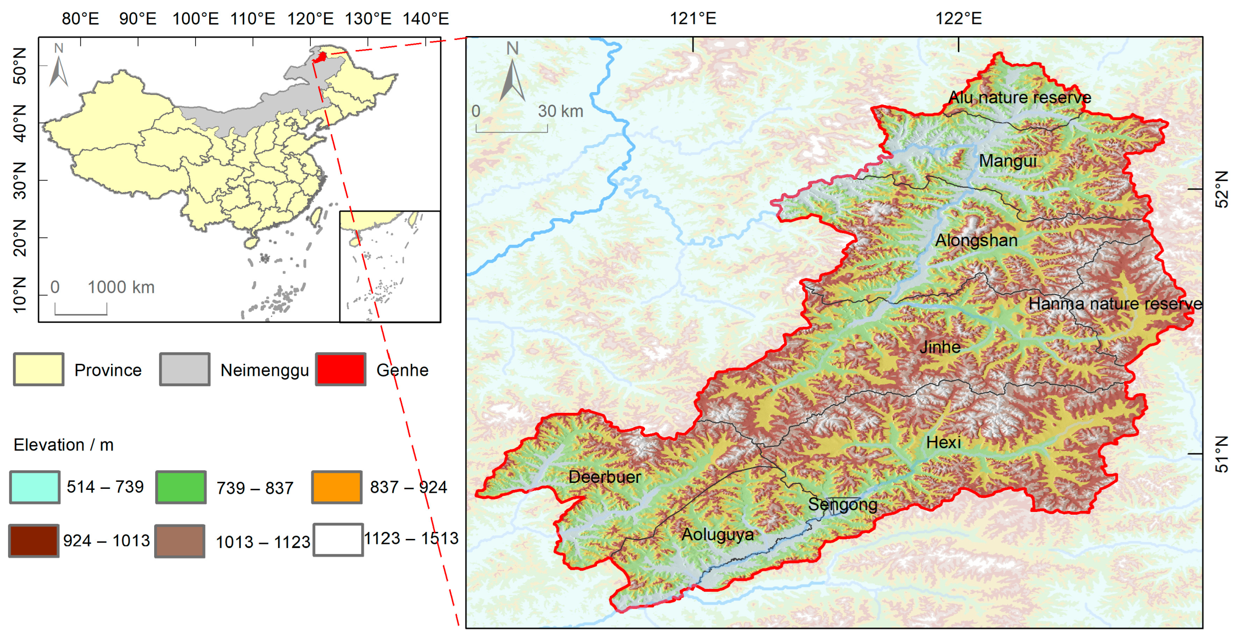
Figure 1. Overview of the study area.
Remotesensing 16 03238 g001
Figure 2. Forest disturbance analysis workflow.
Remotesensing 16 03238 g002
Figure 3. Mapping the forest. (a) OTSU value and forest area every year (Summer & EVI); (b) forest cover synthesis map from 1990 to 2021 (Summer & EVI).
Remotesensing 16 03238 g003
Figure 4. Schematic diagram of typical disturbance types and disturbance processes. (a) Logging in 1999; (b) anthropogenic fire in 2003; (c) wildfires in 2003 and 2010, respectively; (d) logging in 1990 and anthropogenic fire in 2003; (e) EVI curves for the sample points in disturbance areas from (ad), with red boxes indicating disturbance events.
Remotesensing 16 03238 g004
Figure 5. Forest disturbance extraction. (a) Forest disturbance zone; (b) disturbance caused by logging after 1990; (c) disturbance caused by man-made fire in 2003; (d) other disturbances caused by multiple factors such as wildfire, etc.; b1d1 show the results of extracting forest disturbance information, b2d2 display the satellite images that correspond to these areas after the disturbance has occurred; (e) forest disturbance zone after fire-induced disturbances have been removed; (f) annual forest disturbance area caused by fires and other factors; the lines in the plot are the univariate linear trendlines.
Remotesensing 16 03238 g005
Figure 6. Distance of forest disturbance patches from roads and rivers. (a,c) represent the distance of disturbance patches from roads; (b,d) represent the distance of disturbance patches from rivers.
Remotesensing 16 03238 g006
Figure 7. Number of forest disturbance events. (a) Number of forest disturbance events in Genhe; (b) number of forest disturbance events in each administrative unit.
Remotesensing 16 03238 g007
Figure 8. The relationship between forest disturbance and its influencing factors. ai, bi, ci, di, and ei are models of the area of disturbance and its influencing factors (annual precipitation, annual average temperature, annual snow cover days, the annual number of fires, and annual commercial logging output, respectively) for every year; the pink circles are for the anomalous years (2002 and 2003); the period of (a1d1) is from 1991 to 2020; the period of (a2d2) is from 2011 to 2020; the period of (a3c3) is from 1991 to 2020, the disturbance area of (a3c3) is the disturbance caused by factors other than fire; (d3) is the model of the disturbance area and burned area for every year from 1991 to 2020; (e1) annual commercial logging output; the period of (e2,e3) is from 1991 to 2015; the disturbance area of (e3) is the disturbance caused by factors other than fire; the red line in the figure is the univariate linear trendline.
Remotesensing 16 03238 g008
Figure 9. Time and location of forest disturbance and fires. Note: the blue, pink, and purple areas are the areas where disturbances and fires occurred. It should be noted that the purple areas are areas where disturbances and fires occurred in the same year, and other areas with colors (except white and gray) are all where disturbances were detected but the region of fire did not exist in the auxiliary dataset.
Remotesensing 16 03238 g009
Table 1. Datasets used in the study.
DatasetTimeSpatial ResolutionData SourcePurpose
Landsat1990–202130 mGEEExtracting forest areas and detecting forest disturbances
MODIS C62000–20201 kmGEEExtracting annual fire data
ECMWF ERA5 Monthly Aggregates1991–20200.1°GEEExtracting the total precipitation and average temperature during the year
A dataset of snow phenology in China based on AVHRR from 1980 to 20201991–20201 kmNational Cryosphere Desert Data Center, http://www.ncdc.ac.cn (accessed on 26 February 2023)Extracting the total number of snow cover days each year
Openstreet map2022https://wiki.openstreetmap.org/
(accessed on 26 February 2023)
Extracting river and road information
Genhe Chronicle1990–2020Inner Mongolia Culture PressObtaining commercial timber production, large fire incidents, and burned areas
Recorded informationGenhe Forestry Bureau
Table 2. Parameter value range of CCDC on GEE.
ParameterRange
min Observations6
chiSquare Probability0.99
min Num of Years Scaler1.33
λ20/10,000
max Iterations10,000
Table 3. Error matrices of six forest cover maps.
RDSpring & EVISpring & RVISpring & NDVI
FCD FNFUAFNFUAFNFUA
F180214092.79178521889.12168830584.70
NF7198793.297891992.1812388487.79
PA96.2187.5895.8180.8393.2174.35
OA92.9790.1385.73
RDSummer & EVISummer & RVISummer & NDVI
FCD FNFUAFNFUAFNFUA
F185714592.76 180318990.51 178526886.95
NF4195795.89 7293692.86 10384489.12
PA97.8486.8496.1683.2094.5475.90
OA93.8091.3087.63
Note: FCD denotes forest classification data; RD denotes reference data; F denotes forest; NF denotes nonforest; all units of accuracy are %.
Table 4. Error matrices of six forest disturbance maps.
RDSpring & EVISpring & RVISpring & NDVI
DMD DFNDFUADFNDFUADFNDFUA
DF136823285.50 125929780.91 112139274.09
NDF185121586.79 290115479.92 381110674.38
PA88.09 83.97 81.28 79.53 74.63 73.83
OA86.1080.4374.23
RDSummer & EVISummer & RVISummer & NDVI
DMD DFNDFUADFNDFUADFNDFUA
DF140120787.13 125327781.90 121532279.05
NDF153123989.01 265120581.97 305115879.15
PA90.15 85.68 82.54 81.31 79.93 78.24
OA88.0081.9379.10
Note: DMD denotes disturbance monitoring data; RD denotes reference data; DF denotes forest disturbance events with accurate disturbance location and occurrence time; as an illustration, at location A, a disturbance event was initially detected in 2003, and subsequent investigation corroborated its occurrence in the same year; NDF denotes undisturbed or forest disturbance events that were detected but have inaccurate occurrence times; for example, point B was detected as having a disturbance in 2005, but the actual situation occurred in 2008; all units of accuracy are in %.
Disclaimer/Publisher’s Note: The statements, opinions and data contained in all publications are solely those of the individual author(s) and contributor(s) and not of MDPI and/or the editor(s). MDPI and/or the editor(s) disclaim responsibility for any injury to people or property resulting from any ideas, methods, instructions or products referred to in the content.