Histogram-Based Edge Detection for River Coastline Mapping Using UAV-Acquired RGB Imagery
Abstract
1. Introduction
1.1. Context
1.2. Related Work
| No. | Reference | Platform 1|Sensor | Method | Note |
|---|---|---|---|---|
| 1 | Rankin and Matthies (2010) [15] | UGV|RGB | Thresholding, segmentation | Water extent |
| 2 | Namikawa et al. (2016) [12] | S|RGB | Unsupervised classification, thresholding | Water extent |
| 3 | Niedzielski et al. (2016) [7] | UAV|RGB | Manual digitization, statistical analysis | Water stages |
| 4 | Wei and Zhang (2016) [16] | USV|RGB | Structure extraction, texture analysis | |
| 5 | Deng et al. (2017) [13] | S|RGB, NIR, SWIR | Random forest | Water extent |
| 6 | Kröhnert and Meichsner (2017) [18] | P|RGB | Spatio-temporal histogram analysis, segmentation | |
| 7 | Witherow et al. (2017) [27] | LCC|RGB | Threshold-based segmentation | Water extent |
| 8 | Zhan et al. (2017) [17] | USV|RGB | RANSAC algorithm | |
| 9 | Eltner et al. (2018) [19] | LCC|RGB | Spatio-temporal texture, seeded region growing, Canny edge detection | Water stages |
| 10 | Kröhnert and Eltner (2018) [20] | P, LCC|RGB | Spatio-temporal histogram analysis, segmentation | |
| 11 | Ridolfi and Manciola (2018) [23] | UAV|RGB | Pixel classification, Canny edge detection | A dam |
| 12 | Tymków et al. (2019) [24] | UAV|RGB, LiDAR, TIR, RGB+TIR | Supervised classification, thresholding of pixel values, image transforms | Water extent |
| 13 | Viaña-Borja and Ortega-Sanchez (2019) [14] | S|RGB, NIR, SWIR | New water index | |
| 14 | Bandini et al. (2020) [22] | UAV|Radar, LiDAR, RGB | Altimetric measurements, water level extraction of point clouds | Water stages |
| 15 | Xue et al. (2020) [25] | LCC|RGB | Eigen value analysis, gradient distributions | Water images classification |
| 16 | Yu et al. (2020) [26] | LCC|RGB | Improved Local Binary Pattern | Water extent |
| 17 | Eltner et al. (2021) [21] | LCC|RGB | Neural networks |
2. Motivation
3. Materials and Methods
3.1. UAV Data Acquisition and Preprocessing
3.2. Edge Detection
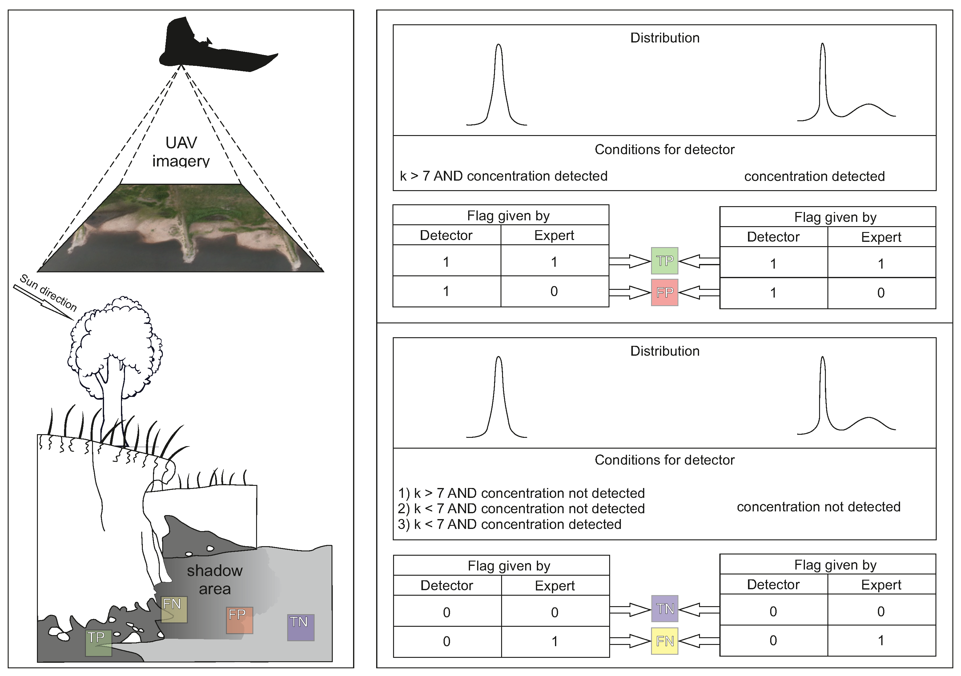
- In the case of one mode (situation 1 above), kurtosis is greater than 7 and concentration of values around the mode is detected using the concentration test with = 0.15;
- In the case of several modes (situation 2 above), the concentration test with = 0.1 suggests a considerable concentration of values around the most frequently occurring mode.
3.3. Accuracy Assessment
3.4. Calibration of Detector
4. Results
4.1. Detection Performance Statistics
4.2. Image-Specific Observations
4.3. Visual Assessment
4.4. Factors Affecting Detection
- Factors which lead to the incorrect detection of river coastlines in places where there are no coastlines (FP):
- −
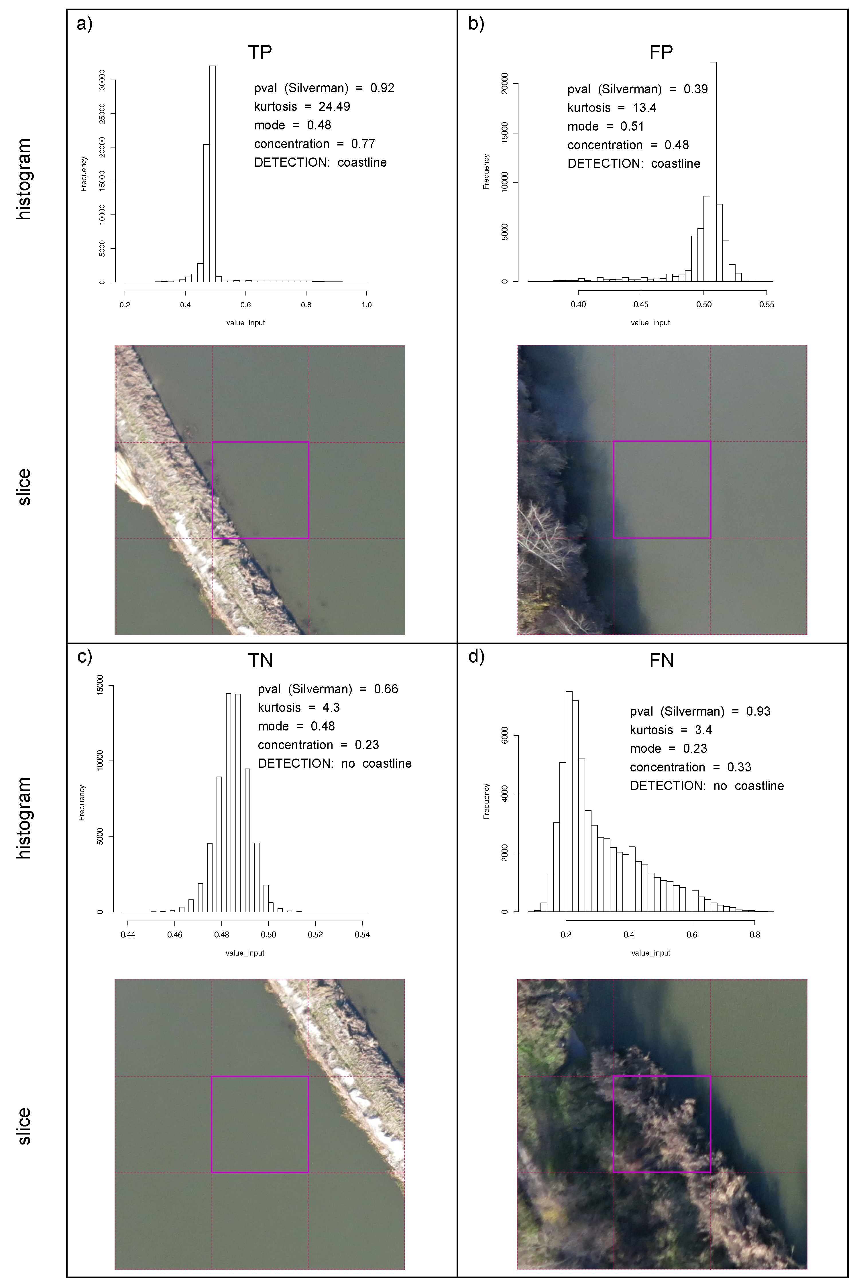
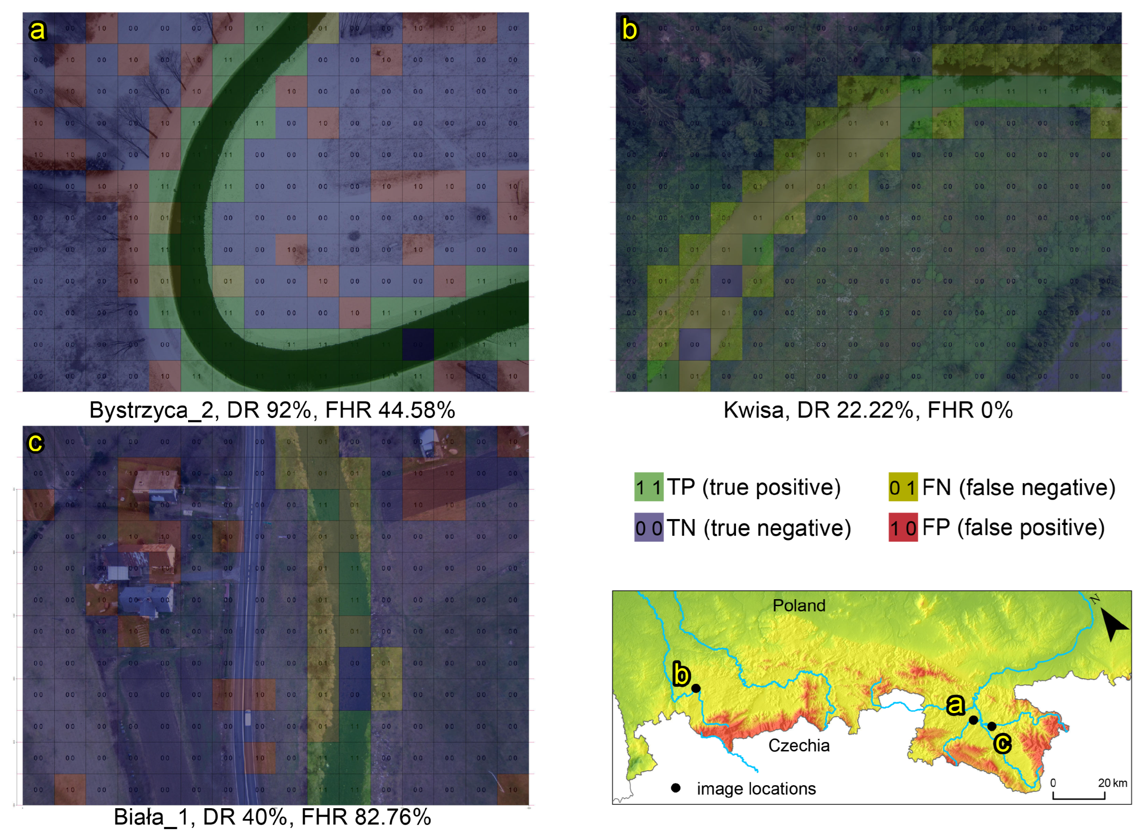
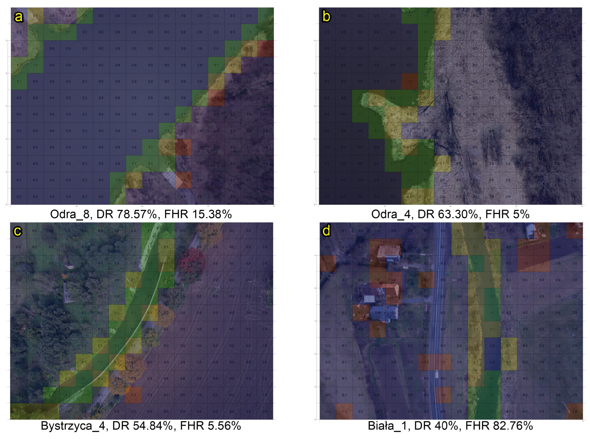
- The occurrence of linear objects and objects with uniform colours (like roads, buildings) in the vicinity of a river (Figure 7c and Figure 8d). The detector interprets these areas as water due to the presence of edges. For the detector, there is no difference between a water edge and the edge of a different uniformly coloured object.
- −
- The presence of continuous and homogeneous snow surface in a photo. If there exist visible natural or artificial objects (such as scrubs, crop field without snow, trees) with colours different than snow and also revealing a linear character, the detector indicates borderline at places other than coastline (Figure 7a).
- −
- Vegetation protruding from water. There is only one false positive in Figure 8b, where an edge was detected between the water surface and vegetation protruding from the water.
- Factors which lead to omitting river banks in places where there are coastlines (FN):
- −
- There occurred cases where the river coastline was clearly visible in the imagery, but the detector did not resolve it, leading to the occurrence of FNs. When river is shallow, underwater bedforms may be visible, thus limiting the waterline detection performance (Figure 8c,d).
- −
- −
5. Discussion
6. Conclusions
Supplementary Materials
Author Contributions
Funding
Data Availability Statement
Conflicts of Interest
Abbreviations
| UAV | Unmanned aerial vehicle |
| RGB | Red, green, blue |
| HSV | Hue saturation value |
| UGV | Unmanned ground vehicle |
| USV | Unmanned surface vehicle |
| ATO | Above take-off |
| DR | Detection rate |
| FHR | False hit rate |
| TP | True positive |
| FN | False negative |
| FP | False positive |
References
- Ledger, M.E.; Milner, A.M. Extreme events in running waters. Freshw. Biol. 2015, 60, 2455–2460. [Google Scholar] [CrossRef]
- Raymond, C.; Horton, R.M.; Zscheischler, J.; Martius, O.; AghaKouchak, A.; Balch, J.; Bowen, S.G.; Camargo, S.J.; Hess, J.; Kornhuber, K.; et al. Understanding and managing connected extreme events. Nat. Clim. Chang. 2020, 10, 611–621. [Google Scholar] [CrossRef]
- Kundzewicz, Z.W.; Pińskwar, I.; Brakenridge, G.R. Changes in river flood hazard in Europe: A review. Hydrol. Res. 2018, 49, 294–302. [Google Scholar] [CrossRef]
- Flener, C.; Vaaja, M.; Jaakkola, A.; Krooks, A.; Kaartinen, H.; Kukko, A.; Kasvi, E.; Hyyppä, H.; Hyyppä, J.; Alho, P. Seamless Mapping of River Channels at High Resolution Using Mobile LiDAR and UAV-Photography. Remote Sens. 2013, 5, 6382–6407. [Google Scholar] [CrossRef]
- Tamminga, A.D.; Eaton, B.C.; Hugenholtz, C.H. UAS-based remote sensing of fluvial change following an extreme flood event. Earth Surf. Process. Landforms 2015, 40, 1464–1476. [Google Scholar] [CrossRef]
- Langhammer, J.; Vacková, T. Detection and Mapping of the Geomorphic Effects of Flooding Using UAV Photogrammetry. Pure Appl. Geophys. 2018, 175, 3223–3245. [Google Scholar] [CrossRef]
- Niedzielski, T.; Witek, M.; Spallek, W. Observing river stages using unmanned aerial vehicles. Hydrol. Earth Syst. Sci. 2016, 20, 3193–3205. [Google Scholar] [CrossRef]
- Hemmelder, S.; Marra, W.; Markies, H.; De Jong, S.M. Monitoring river morphology & bank erosion using UAV imagery—A case study of the river Buëch, Hautes-Alpes, France. Int. J. Appl. Earth Obs. Geoinf. 2018, 73, 428–437. [Google Scholar]
- Tsatsaris, A.; Kalogeropoulos, K.; Stathopoulos, N.; Louka, P.; Tsanakas, K.; Tsesmelis, D.E.; Krassanakis, V.; Petropoulos, G.P.; Pappas, V.; Chalkias, C. Geoinformation Technologies in Support of Environmental Hazards Monitoring under Climate Change: An Extensive Review. Isprs Int. J.-Geo-Inf. 2021, 10, 94. [Google Scholar] [CrossRef]
- Karamuz, E.; Romanowicz, R.J.; Doroszkiewicz, J. The use of unmanned aerial vehicles in flood hazard assessment. J. Flood Risk Manag. 2020, 13, e12622. [Google Scholar] [CrossRef]
- Ibrahim, N.S.; Sharun, S.M.; Osman, M.K.; Mohamed, S.B.; Abdullah, S.H.Y.S. The application of UAV images in flood detection using image segmentation techniques. Indones. J. Electr. Eng. Comput. Sci. 2021, 23, 1219–1226. [Google Scholar] [CrossRef]
- Namikawa, L.M.; Körting, T.S.; Castejon, E.F. Water body extraction from RapidEye images: An automated methodology based on Hue component of color transformation from RGB to HSV model. Braz. J. Cartogr. 2016, 68, 1097–1111. [Google Scholar] [CrossRef]
- Deng, Y.; Jiang, W.; Tang, Z.; Li, J.; Lv, J.; Chen, Z.; Jia, K. Spatio-Temporal Change of Lake Water Extent in Wuhan Urban Agglomeration Based on Landsat Images from 1987 to 2015. Remote Sens. 2017, 9, 270. [Google Scholar] [CrossRef]
- Viaña-Borja, S.P.; Ortega-Sánchez, M. Automatic Methodology to Detect the Coastline from Landsat Images with a New Water Index Assessed on Three Different Spanish Mediterranean Deltas. Remote Sens. 2019, 11, 2186. [Google Scholar] [CrossRef]
- Rankin, A.; Matthies, L. Daytime Water Detection Based on Color Variation. In Proceedings of the IEEE/RSJ International Conference on Intelligent Robots and Systems, Taipei, Taiwan, 18–22 October 2010. [Google Scholar]
- Wei, Y.; Zhang, Y. Effective Waterline Detection of Unmanned Surface Vehicles Based on Optical Images. Sensors 2016, 16, 1590. [Google Scholar] [CrossRef] [PubMed]
- Zhan, W.; Xiao, C.; Yuan, H.; Wen, Y. Effective Waterline Detection for Unmanned Surface Vehicles in Inland Water. In Proceedings of the Seventh International Conference on Image Processing Theory, Tools and Applications (IPTA), Montreal, QC, Canada, 28 November–1 December 2017. [Google Scholar]
- Kröhnert, M.; Meichsner, R. Segmentation of Environmental Time Lapse Image Sequences for the Determination of Shore Lines Captured by Hand-Held Smartphone Cameras. ISPRS Ann. Photogramm. Remote. Sens. Spat. Inf. Sci. 2017, IV-2/W4, 1–8. [Google Scholar] [CrossRef]
- Eltner, A.; Elias, M.; Sardemann, H.; Spieler, D. Automatic Image-Based Water Stage Measurement for Long-Term Observations in Ungauged Catchments. Water Resour. Res. 2018, 54, 362–371. [Google Scholar] [CrossRef]
- Kröhnert, M.; Eltner, A. Versatile mobile and stationary low-cost approaches for hydrological measurements. Int. Arch. Photogramm. Remote. Sens. Spat. Inf. Sci. 2018, XLII-2, 543–550. [Google Scholar] [CrossRef]
- Eltner, A.; Bressan, P.O.; Akiyama, T.; Gonçalves, W.N.; Marcato, J., Jr. Using Deep Learning for Automatic Water Stage Measurements. Water Resour. Res. 2021, 57, e2020WR027608. [Google Scholar] [CrossRef]
- Bandini, F.; Sunding, T.P.; Linde, J.; Smith, O.; Jensen, I.K.; Köppl, C.J.; Butts, M.; Bauer-Gottwein, P. Unmanned Aerial System (UAS) observations of water surface elevation in a small stream: Comparison of radar altimetry, LIDAR and photogrammetry techniques. Remote Sens. Environ. 2020, 237, 111487. [Google Scholar] [CrossRef]
- Ridolfi, E.; Manciola, P. Water Level Measurements from Drones: A Pilot Case Study at a Dam Site. Water 2018, 10, 297. [Google Scholar] [CrossRef]
- Tymków, P.; Jóźków, G.; Walicka, A.; Karpina, M.; Borkowski, A. Identification of Water Body Extent Based on Remote Sensing Data Collected with Unmanned Aerial Vehicle. Water 2019, 11, 338. [Google Scholar] [CrossRef]
- Xue, M.; Shivakumara, P.; Wu, X.; Lu, T.; Pal, U.; Blumenstein, M.; Lopresti, D. Deep invariant texture features for water image classification. Appl. Sci. 2020, 2, 2068. [Google Scholar] [CrossRef]
- Yu, J.; Lin, Y.; Zhu, Y.; Xu, W.; Hou, D.; Huang, P.; Zhang, G. Segmentation of River Scenes Based on Water Surface Reflection Mechanism. Appl. Sci. 2020, 10, 2471. [Google Scholar] [CrossRef]
- Witherow, M.A.; Elbakary, M.I.; Iftekharuddin, K.M.; Cetin, M. Analysis of Crowdsourced Images for Flooding Detection. In Proceedings of the VI ECCOMAS Thematic Conference on Computational Vision and Medical Image Processing, Porto, Portugal, 18–20 October 2017. [Google Scholar]
- Kucharczyk, M.; Hugenholtz, C.H. Remote sensing of natural hazard-related disasters with small drones: Global trends, biases, and research opportunities. Remote Sens. Environ. 2021, 264, 112577. [Google Scholar] [CrossRef]
- Zhang, Z.; Zhu, L. A Review on Unmanned Aerial Vehicle Remote Sensing: Platforms, Sensors, Data Processing Methods, and Applications. Drones 2023, 7, 398. [Google Scholar] [CrossRef]
- Rao, B.; Gopi, A.G.; Maione, R. The societal impact of commercial drones. Technol. Soc. 2016, 45, 83–90. [Google Scholar] [CrossRef]
- Aydin, B. Public acceptance of drones: Knowledge, attitudes, and practice. Technol. Soc. 2019, 59, 101180. [Google Scholar] [CrossRef]
- Maddikunta, P.K.R.; Hakak, S.; Alazab, M.; Bhattacharya, S.; Gadekallu, T.R.; Khan, W.Z.; Pham, Q.V. Unmanned aerial vehicles in smart agriculture: Applications, requirements, and challenges. IEEE Sens. J. 2021, 21, 17608–17619. [Google Scholar] [CrossRef]
- Sun, W.; Chen, C.; Liu, W.; Yang, G.; Meng, X.; Wang, L.; Ren, K. Coastline extraction using remote sensing: A review. Giscience Remote. Sens. 2023, 60, 2243671. [Google Scholar] [CrossRef]
- Abdullah, S.L.S.; Hambali, H.A.; Jamil, N. Segmentation of Natural Images Using an Improved Thresholding-Based Technique. Procedia Eng. 2012, 41, 938–944. [Google Scholar] [CrossRef]
- Silverman, B.W. Using kernel density estimates to investigate multimodality. J. R. Stat. Soc. Ser. B 1981, 43, 97–99. [Google Scholar] [CrossRef]
- Curran, P.J.; West, S.G.; Finch, J.F. The robustness of test statistics to nonnormality and specification error in confirmatory factor analysis. Psychol. Methods 1996, 1, 16–29. [Google Scholar] [CrossRef]
- West, S.G.; Finch, J.F.; Curran, P.J. Structural equation models with nonnormal variables: Problems and remedies. In Structural Equation Modeling: Concepts, Issues, and Applications; Hoyle, R.H., Ed.; Sage: New York, NY, USA, 1995; pp. 56–75. [Google Scholar]
- Kim, H.Y. Statistical notes for clinical researchers: Assessing normal distribution (2) using skewness and kurtosis. Restor. Dent. Endod. 2013, 38, 53–54. [Google Scholar] [CrossRef] [PubMed]
- Niedzielski, T.; Jurecka, M.; Stec, M.; Wieczorek, M.; Miziński, B. The nested k-meansmethod: A new approach for detecting lost persons in aerial images acquired by unmanned aerial vehicles. J. Field Robot. 2017, 34, 1395–1406. [Google Scholar] [CrossRef]
- Canny, J. A Computational Approach to Edge Detection. IEEE Trans. Pattern Anal. Mach. Intell. 1987, 6, 184–203. [Google Scholar]
- Namikawa, L.M. Imagens landsat 8 para monitoramento de volume de água em reservatórios: Estudo de caso nas barragens Jaguari e Jacareí do Sistema Cantareira. SimpóSio Bras. Sensoriamento Remoto 2015, 17, 4828–4835. [Google Scholar]
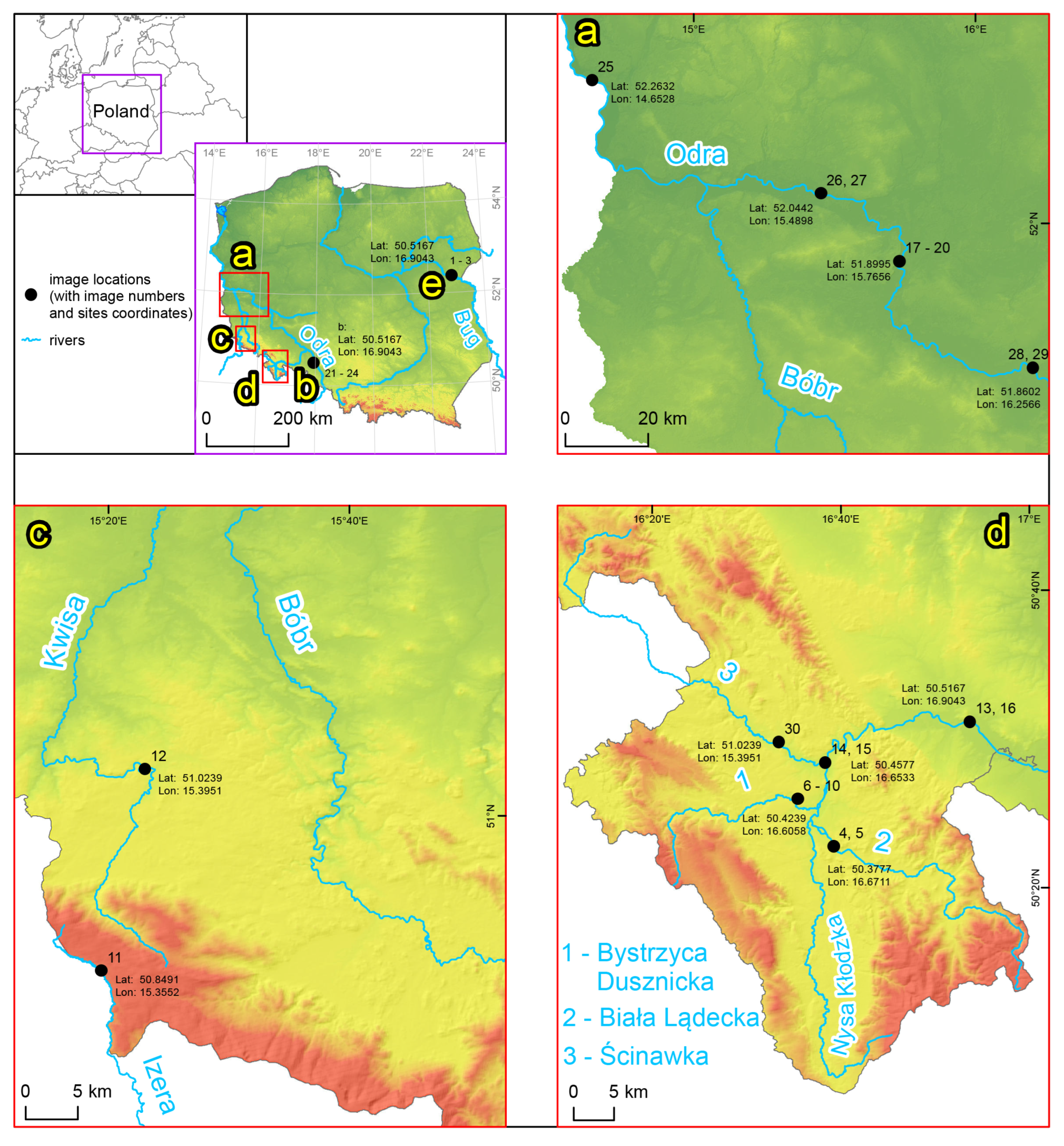
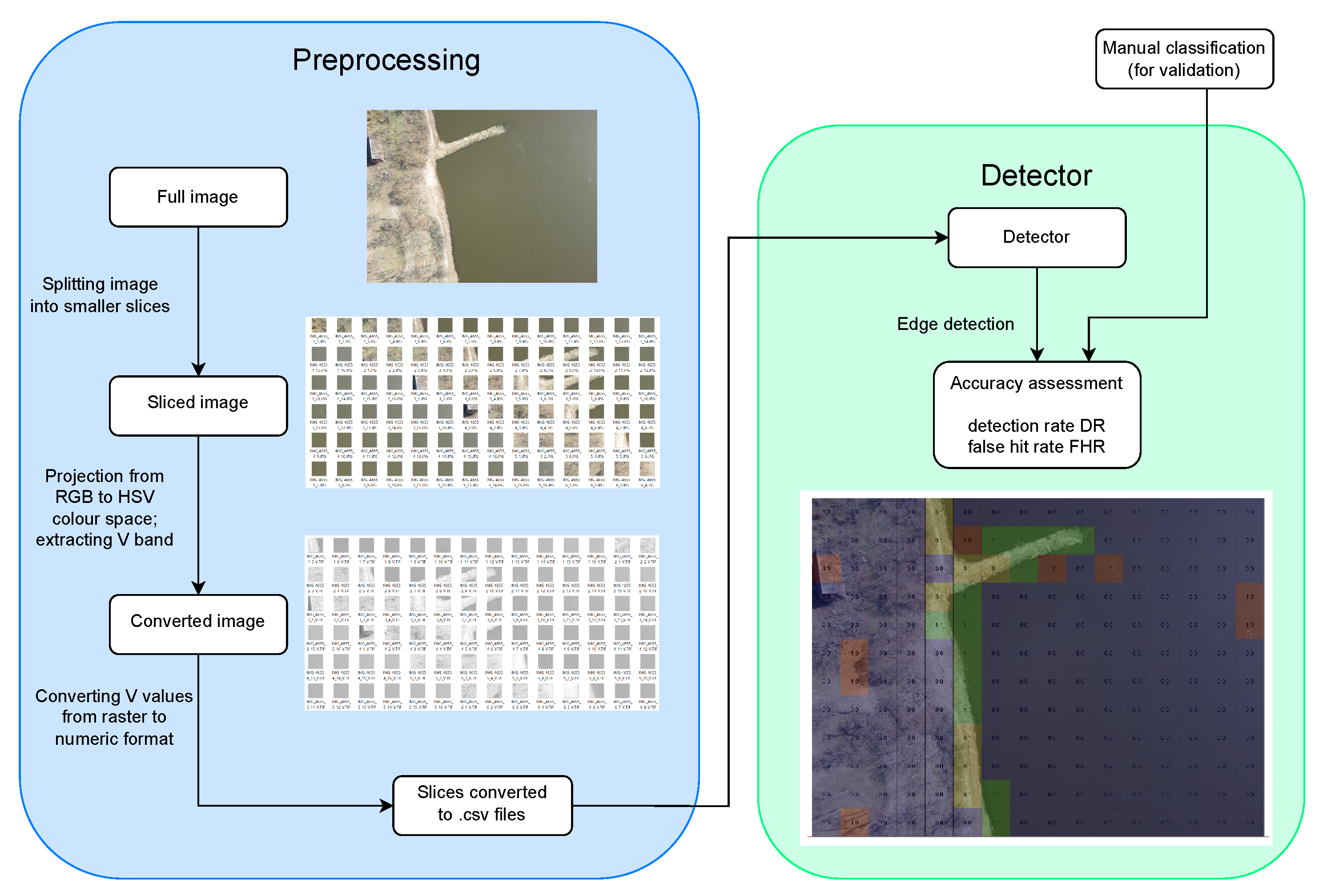


| Reference | Location in Text | Information on RGB |
|---|---|---|
| Kucharczyk and Hugenholtz [28] | Table 5 in [28] | 86.77% articles (from among 635 papers) use RGB sensors |
| Zhang and Zhu [29] | SubSection 2.2.1 in [29] | RGB cameras are prevailing type of remote sensing sensor mounted onboard UAVs |
| Rao et al. [30] | SubSection 2.2 in [30] | Aerial photography is the most common usage of consumer and hobbyist UAVs |
| Aydin [31] | Section Background in [31] | Based on Federal Aviation Administration Aerospace Report 2017, 3.55–4.47 million hobbyist drones were predicted to 2021 (following [30], hobbyist drones are used mainly for photography—see previous row in this Table) |
| Maddikunta et al. [32] | Paragraph II C 4) (a) in [32] | RGB cameras are the most popular sensors in precision agriculture and smart agro applications |
| No. | Image Name | Type 1 | Min. Width 2 [m] | Max. Width [m] | Length [m] | Water Level [cm] | Mean Water Level [cm] | Discharge [] |
|---|---|---|---|---|---|---|---|---|
| 1 | Bug_1 | lowland | 83 | 98 | 165 | 240 b | 302 | 49.30 |
| 2 | Bug_2 | lowland | 90 | 100 | 140 | 230 b | 296 | 42.20 |
| 3 | Bug_3 | lowland | 80 | 90 | 150 | 230 b | 296 | 42.20 |
| 4 | Biała_1 | upland | 11 | 16 | 115 | 42 b | 55 | 2.78 |
| 5 | Biała_2 | upland | 11 | 16 | 130 | 67 a | 52 | 4.04 |
| 6 | Bystrzyca_1 | upland | 0 | 9 | 165 | 19 | 19 | 1.88 |
| 7 | Bystrzyca_2 | upland | 9 | 11 | 200 | 19 | 19 | 1.88 |
| 8 | Bystrzyca_3 | upland | 6 | 11 | 175 | 4 b | 19 | 0.91 |
| 9 | Bystrzyca_4 | upland | 1 | 10 | 115 | 12 b | 19 | 1.44 |
| 10 | Bystrzyca_5 | upland | 7 | 11 | 225 | 121 | 5.67 | |
| 11 | Izera | mountain | 0 | 11 | 95 | No data | No data | 0.15 |
| 12 | Kwisa | mountain | 7 | 20 | 200 | 107 b | 115 | No data |
| 13 | Nysa_1 | upland | 23 | 38 | 135 | 98 a | 96 | 20.50 |
| 14 | Nysa_2 | upland | 5 | 25 | 180 | 89 b | 101 | 4.37 |
| 15 | Nysa_3 | upland | 5 | 25 | 190 | 88 b | 112 | 5.08 |
| 16 | Nysa_4 | upland | 19 | 34 | 135 | 80 b | 96 | 10.50 |
| 17 | Odra_1 | lowland | NA | NA | NA | 165 b | 178 | 105.00 |
| 18 | Odra_2 | lowland | 75 | 130 | 125 | 133 b | 178 | 77.10 |
| 19 | Odra_3 | lowland | 70 | 78 | 115 | 167 b | 245 | 107.00 |
| 20 | Odra_4 | lowland | NA | NA | NA | 175 b | 178 | 115.00 |
| 21 | Odra_5 | lowland | 93 | 100 | 145 | 230 b | 232 | No data |
| 22 | Odra_6 | lowland | 115 | 120 | 165 | 230 b | 232 | No data |
| 23 | Odra_7 | lowland | 90 | 105 | 150 | 229 b | 232 | No data |
| 24 | Odra_8 | lowland | 95 | 125 | 160 | 225 b | 240 | No data |
| 25 | Odra_9 | lowland | 100 | 235 | 115 | 189 a | 167 | 204.00 |
| 26 | Odra_10 | lowland | 83 | 130 | 140 | 164 b | 179 | 108.00 |
| 27 | Odra_11 | lowland | 96 | 145 | 85 | 187 b | 242 | 136.00 |
| 28 | Odra_12 | lowland | 66 | 153 | 160 | 218 b | 233 | 101.00 |
| 29 | Odra_13 | lowland | 75 O;25 B | 145 O;55B | 145 O;125 B | 233 O;177 B | 135.00 O;17.30 B | |
| 30 | Ścinawka | upland | 0 | 20 | 140 | 221a | 51 | 46.30 |
| No. | River | Region | Image Name | Date | Coverage Water Class 1 | Land Cover | Channel Characteristic | Detection Disturbances |
|---|---|---|---|---|---|---|---|---|
| 1 | Bug_1 | 27/07/2017 | 2 | coniferous forest, scrub, meadow | visible two banks | shadows, sunlight reflections | ||
| 2 | Bug | Binduga | Bug_2 | 26/06/2018 | 3 | scrub | visible two banks | – |
| 3 | Bug_3 | 26/06/2018 | 3 | coniferous forest, scrub | partially covered two banks | shadows, reflections | ||
| 4 | Biała Lądecka | Żelazno | Biała_1 | 27/11/2012 | 1 | scrub, meadow, arable land, discontinuous building, roads | visible two banks | visible riverbed forms and submerged vegetation |
| 5 | Biała_2 | 21/05/2015 | 1 | scrub, meadow, arable land, discontinuous building, roads | partially covered two banks; submerged bars | shadows, visible riverbed forms and submerged vegetation | ||
| 6 | Bystrzyca_1 | 08/01/2013 | 1 | broad-leaved forest, coniferous trees, meadow, discontinuous building | defence; partially covered two banks | – | ||
| 7 | Bystrzyca_2 | 08/01/2013 | 1 | broad-leaved and coniferous trees, meadow, roads | defence; visible two banks | local hydraulic disturbances; white water | ||
| 8 | Bystrzyca Dusznicka | Szalejów Dolny | Bystrzyca_3 | 21/08/2013 | 1 | broad-leaved trees, meadow, arable land, roads | defence; partially covered two banks; sand bars | visible riverbed forms; local hydraulic disturbances; white water |
| 9 | Bystrzyca_4 | 27/09/2013 | 1 | broad-leaved trees, scrub, meadow, arable land, discontinuous building, roads | defence; partially covered two banks | surface waves; visible riverbed forms; submerged vegetation | ||
| 10 | Bystrzyca_5 | 29/06/2020 | 1 | broad-leaved trees, scrub, meadow, arable land, roads | defence; partially covered two banks | surface waves; white water | ||
| 11 | Izera | Hala Izerska | Izera | 30/08/2019 | 1 | coniferous forest and trees, meadow | partially covered two banks; bars (mostly submerged) | visible riverbed forms |
| 12 | Kwisa | Gryfów Śląski | Kwisa | 29/06/2016 | 1 | coniferous forest, scrub, meadow | partially covered two banks | shadows; reflections; surface waves; local hydraulic disturbances; visible riverbed forms and submerged vegetation |
| 13 | Byczeń | Nysa_1 | 30/03/2021 | 2 | broad-leaved trees, meadow, gravel-sand bar | visible two banks; bars (partially submerged) | surface waves; visible riverbed forms | |
| 14 | Nysa Kłodzka | Ławica | Nysa_2 | 04/07/2019 | 1 | broad-leaved forest, meadow | partially covered two banks; bars (partially submerged); submerged vegetation | shadows; reflections; surface waves; local hydraulic disturbances; visible riverbed forms and submerged vegetation |
| 15 | Nysa_3 | 04/12/2019 | 1 | broad-leaved forest, meadow, arable land | partially covered two banks | shadows; surface waves; visible riverbed forms and submerged vegetation | ||
| 16 | Odra | Śrem | Nysa_4 | 22/06/2021 | 1 | broad-leaved forest, scrub, meadow | partially covered two banks | shadows |
| 17 | Odra_1 | 09/12/2021 | 4 | broad-leaved forest, meadow | visible one bank; groynes | shadows | ||
| 18 | Dąbrowa | Odra_2 | 10/11/2021 | 4 | broad-leaved forest, scrub, sand bars | visible two bank; groynes; sand bars | shadows; visible riverbed forms | |
| 19 | Odra_3 | 26/07/2021 | 3 | broad-leaved trees, meadow, arable land | visible two banks | shadows, reflections | ||
| 20 | Odra_4 | 27/03/2022 | 2 | broad-leaved forest, scrub | visible one bank; groyne | – | ||
| 21 | Gogolin | Odra_5 | 21/11/2020 | 2 | broad-leaved trees, scrub, arable land, roads | visible one bank | surface waves | |
| 22 | Odra_6 | 21/11/2020 | 3 | broad-leaved trees, scrub, arable land, road | partially covered two banks; river regulation structures | shadows; white water | ||
| 23 | Odra_7 | 22/11/2020 | 4 | broad-leaved forest, scrub | partially covered two banks | sunlight reflections; surface waves | ||
| 24 | Odra_8 | 17/02/2020 | 3 | broad-leaved forest, scrub, road | partially covered two banks | visible riverbed forms | ||
| 25 | Kunice | Odra_9 | 24/03/2022 | 3 | broad-leaved trees, scrub, building | visible one bank; groyne | shadows; white water | |
| 26 | Pomorsko | Odra_10 | 06/12/2021 | 3 | broad-leaved trees, scrub | visible one bank; groynes; submerged bars | shadows; visible riverbed forms | |
| 27 | Odra_11 | 28/06/2021 | 4 | scrub | visible one bank | – | ||
| 28 | Wyszanów | Odra_12 | 07/12/2021 | 3 | broad-leaved trees, scrub | visible one bank; groynes; submerged bars | visible riverbed forms | |
| 29 | Odra/Barycz | Odra_13 | 31/01/2022 | 3 | broad-leaved trees, meadow | partially covered three 2 banks | shadows | |
| 30 | Ścinawka | Gorzuchów | Ścinawka | 14/10/2020 | 1 | broad-leaved trees, scrub, meadow, arable land, road, water body | almost all covered banks (both river and water body) | shadows; surface waves; white water |
| 1 | 2 | 3 | ||
|---|---|---|---|---|
| Scenario | Kurtosis | * for One of Distribution | 2 OR/AND 3 | |
| Unimodal | Multimodal | |||
| S1 | 6 | 0.1 | 0.05 | OR |
| S2 | 7 | 0.1 | 0.05 | OR |
| S3 | 7 | 0.1 | 0.05 | AND |
| S4 | 7 | 0.15 | 0.1 | OR |
| S5 | 7 | 0.15 | 0.1 | AND |
| S6 | 20 | 0.1 | 0.05 | OR |
| S7 | 20 | 0.1 | 0.05 | AND |
| S8 | 20 | 0.15 | 0.1 | OR |
| S9 | 20 | 0.15 | 0.1 | AND |
| Scenario | Odra_6 | Ścinawka | Bystrzyca_1 | Bystrzyca_2 | Lake_1 1 | Odra_7 | Bug_1 | |||||||
|---|---|---|---|---|---|---|---|---|---|---|---|---|---|---|
| DR | FHR | DR | FHR | DR | FHR | DR | FHR | DR | FHR | DR | FHR | DR | FHR | |
| S1 | 72.88 | 39.44 | 38.64 | 66.67 | 82.93 | 55.26 | 96.00 | 63.36 | 88.89 | 82.42 | 72.73 | 64.18 | 80.77 | 75.58 |
| S2 | 71.19 | 34.38 | 38.64 | 64.58 | 82.93 | 52.11 | 96.00 | 52.94 | 88.89 | 81.18 | 72.73 | 62.50 | 80.77 | 74.70 |
| S3 | 66.10 | 25.00 | 38.64 | 63.04 | 75.61 | 43.64 | 96.00 | 52.94 | 77.78 | 80.82 | 60.61 | 44.44 | 69.23 | 66.04 |
| S4 | 62.71 | 32.73 | 31.82 | 56.25 | 68.29 | 48.15 | 92.00 | 58.18 | 66.67 | 77.36 | 48.48 | 69.23 | 73.08 | 72.46 |
| S5 | 62.71 | 22.92 | 31.82 | 53.33 | 65.85 | 32.50 | 92.00 | 44.58 | 61.11 | 74.42 | 42.42 | 39.13 | 65.38 | 61.36 |
| S6 | 71.19 | 30.00 | 38.64 | 63.83 | 82.93 | 47.69 | 96.00 | 57.14 | 88.89 | 80.49 | 72.73 | 54.72 | 73.08 | 72.86 |
| S7 | 55.93 | 21.43 | 38.64 | 62.22 | 78.05 | 33.33 | 94.00 | 46.59 | 55.56 | 84.62 | 54.55 | 28.00 | 69.23 | 63.27 |
| S8 | 62.71 | 26.00 | 31.82 | 53.33 | 68.29 | 34.88 | 92.00 | 47.73 | 66.67 | 73.91 | 48.48 | 56.76 | 65.38 | 69.64 |
| S9 | 50.85 | 21.05 | 31.82 | 54.84 | 65.85 | 27.03 | 90.00 | 40.79 | 38.89 | 81.58 | 39.39 | 27.78 | 61.54 | 58.97 |
| No. | River | Region | Image Name | 250 × 250 px | 125 × 125 px | ||
|---|---|---|---|---|---|---|---|
| DR | FHR | DR | FHR | ||||
| 1 | Bug | Binduga | Bug_1 | 65.38 | 61.36 | 55.32 | 81.02 |
| 2 | Bug_2 | 65.38 | 26.09 | 51.22 | 54.35 | ||
| 3 | Bug_3 | 44.12 | 6.25 | 41.27 | 31.58 | ||
| 4 | Biała Lądecka | Żelazno | Biała_1 | 40.00 | 82.76 | 54.55 | 81.25 |
| 5 | Biała_2 | 39.39 | 62.86 | 31.82 | 76.67 | ||
| 6 | Bystrzyca Dusznicka | Szalejów Dolny | Bystrzyca_1 | 65.85 | 32.50 | 70.93 | 53.44 |
| 7 | Bystrzyca_2 | 92.16 | 43.37 | 89.69 | 57.14 | ||
| 8 | Bystrzyca_3 | 72.09 | 40.38 | 61.18 | 49.02 | ||
| 9 | Bystrzyca_4 | 54.84 | 5.56 | 59.38 | 25.49 | ||
| 10 | Bystrzyca_5 | 36.36 | 15.79 | 34.07 | 44.64 | ||
| 11 | Izera | Hala Izerska | Izera | 42.86 | 25.00 | 40.00 | 36.84 |
| 12 | Kwisa | Gryfów Śląski | Kwisa | 22.22 | 0.00 | 24.42 | 51.16 |
| 13 | Nysa Kłodzka | Byczeń | Nysa_1 | 88.57 | 48.33 | 57.61 | 53.10 |
| 14 | Ławica | Nysa_2 | 57.45 | 42.55 | 42.42 | 53.33 | |
| 15 | Nysa_3 | 51.28 | 28.57 | 42.67 | 65.22 | ||
| 16 | Śrem | Nysa_4 | 54.55 | 45.45 | 34.85 | 62.90 | |
| 17 | Odra | Dąbrowa | Odra_1 | 60.87 | 41.67 | 45.24 | 70.77 |
| 18 | Odra_2 | 46.67 | 41.67 | 42.86 | 53.45 | ||
| 19 | Odra_3 | 60.60 | 28.57 | 67.24 | 23.53 | ||
| 20 | Odra_4 | 63.30 | 5.00 | 60.42 | 19.44 | ||
| 21 | Gogolin | Odra_5 | 47.62 | 65.52 | 50.00 | 71.01 | |
| 22 | Odra_6 | 62.71 | 22.92 | 40.68 | 48.39 | ||
| 23 | Odra_7 | 42.42 | 39.13 | 35.38 | 70.89 | ||
| 24 | Odra_8 | 78.57 | 15.38 | 59.26 | 42.86 | ||
| 25 | Kunice | Odra_9 | 61.90 | 38.10 | 65.12 | 41.67 | |
| 26 | Pomorsko | Odra_10 | 59.09 | 50.00 | 56.10 | 70.89 | |
| 27 | Odra_11 | 55.56 | 56.52 | 53.12 | 83.00 | ||
| 28 | Wyszanów | Odra_12 | 66.67 | 60.78 | 57.14 | 66.97 | |
| 29 | Odra_13 | 61.90 | 38.10 | 43.18 | 50.65 | ||
| 30 | Ścinawka | Gorzuchów | Ścinawka | 31.82 | 53.33 | 37.35 | 71.03 |
| std | 15.34 | 19.80 | 13.53 | 17.09 | |||
| range | 69.78 | 82.76 | 65.27 | 63.56 | |||
| Reference | Strength | Weakness |
|---|---|---|
| Namikawa et al. (2016) [12] | Simple method without user intervention and with little computational power | Noisy pixels must be eliminated |
| Niedzielski et al. (2016) [7] | Highly available (RGB consumer-grade camera mounted on UAV needed) | Manual digitization needed |
| Wei and Zhang (2016) [16] | Effective and robust method | Shadow sensitive method |
| Kröhnert and Meichsner (2017) [18] | Highly available (smartphone needed) | Method sensitive on users motions and vegetation moving in the wind |
| Eltner et al. (2018) [19] | Highly available (low-cost camera needed) | Direct access to river vicinity needed, GCPs and total station required |
| Ridolfi and Manciola (2018) [23] | Rapid and inexpensive procedure | GCPs required |
| Tymków et al. (2019) [24] | High overall accuracy | Additional sensor required (best results obtained for RGB+TIR combination) |
| Eltner et al. (2021) [21] | Highly available (low-cost camera needed) | Direct access to river vicinity needed, GCPs and total station required |
Disclaimer/Publisher’s Note: The statements, opinions and data contained in all publications are solely those of the individual author(s) and contributor(s) and not of MDPI and/or the editor(s). MDPI and/or the editor(s) disclaim responsibility for any injury to people or property resulting from any ideas, methods, instructions or products referred to in the content. |
© 2024 by the authors. Licensee MDPI, Basel, Switzerland. This article is an open access article distributed under the terms and conditions of the Creative Commons Attribution (CC BY) license (https://creativecommons.org/licenses/by/4.0/).
Share and Cite
Walusiak, G.; Witek, M.; Niedzielski, T. Histogram-Based Edge Detection for River Coastline Mapping Using UAV-Acquired RGB Imagery. Remote Sens. 2024, 16, 2565. https://doi.org/10.3390/rs16142565
Walusiak G, Witek M, Niedzielski T. Histogram-Based Edge Detection for River Coastline Mapping Using UAV-Acquired RGB Imagery. Remote Sensing. 2024; 16(14):2565. https://doi.org/10.3390/rs16142565
Chicago/Turabian StyleWalusiak, Grzegorz, Matylda Witek, and Tomasz Niedzielski. 2024. "Histogram-Based Edge Detection for River Coastline Mapping Using UAV-Acquired RGB Imagery" Remote Sensing 16, no. 14: 2565. https://doi.org/10.3390/rs16142565
APA StyleWalusiak, G., Witek, M., & Niedzielski, T. (2024). Histogram-Based Edge Detection for River Coastline Mapping Using UAV-Acquired RGB Imagery. Remote Sensing, 16(14), 2565. https://doi.org/10.3390/rs16142565


