Technical Note

Precise Orbit Determination for Maneuvering HY2D Using Onboard GNSS Data

1
Shanghai Astronomical Observatory, Chinese Academy of Sciences, Shanghai 200030, China
2
School of Astronomy and Space Science, University of Chinese Academy of Sciences, Beijing 100049, China
3
Shanghai Key Laboratory of Space Navigation and Positioning Techniques, Shanghai 200030, China
4
National Satellite Ocean Application Service, Beijing 100081, China
5
Beijing Research Institute of Telemetry, Beijing 100076, China
*
Author to whom correspondence should be addressed.
Remote Sens. 2024, 16(13), 2410; https://doi.org/10.3390/rs16132410
Submission received: 24 May 2024 / Revised: 25 June 2024 / Accepted: 30 June 2024 / Published: 1 July 2024
(This article belongs to the Special Issue GNSS Positioning and Navigation in Remote Sensing Applications)

Abstract

:
The Haiyang-2D (HY2D) satellite is the fourth ocean dynamics environment monitoring satellite launched by China. The satellite operates on a re-entry frozen orbit, which necessitates orbital maneuvers to maintain its designated path once the satellite’s sub-satellite point deviates beyond a certain threshold. However, the execution of orbit maneuvers presents a significant challenge to the field of Precise Orbit Determination (POD). The thesis selects the on-board GPS data of HY2D satellite in December 2023 and five maneuvering days of that year. Employing a multifaceted approach that includes the assessment of observational data quality, orbit overlap, external orbit validation, and SLR (Satellite Laser Ranging) verification, the research delves into precise orbit determination during both maneuver and non-maneuver periods. The results indicate that: (1) The average number of satellites tracked by the receiver is 6.4; (2) During the non-maneuver periods, the average RMS (Root Mean Square) value of the radial difference in the 6-h overlapping arc segment is 0.66 cm, and the three-dimensional position difference is about 1.16 cm; (3) When compared with the precision science orbits (PSO) provided by CNES (Centre National d’Études Spatiales), the average values of the RMS values of the differences in the radial (R), transverse (T), and normal (N) directions during the non-maneuver and maneuver periods are respectively 1.32 cm, 2.31 cm, 1.92 cm and 3.04 cm, 8.78 cm, 2.72 cm. (4) The SLR verification of the orbit revealed a residual RMS of 2.24 cm. This suggests that by incorporating the modeling of maneuver forces during the maneuver periods, the impact of orbital maneuvers on orbit determination can be mitigated.

1. Introduction

As satellite navigation technology extends its reach into various application domains and onboard Global Navigation Satellite System (GNSS) technology matures, Low Earth Orbit (LEO) satellites are increasingly utilized for a multitude of applications, including Earth remote sensing, gravity field inversion, and meteorological exploration [1,2,3]. Under conditions devoid of orbital maneuvers, orbit determination precision based on dual-frequency GPS can achieve centimeter-level accuracy [4,5,6]. However, due to factors such as atmospheric drag, non-spherical gravity of the Earth, and special mission requirements, LEO satellites need to perform necessary maneuvers during their lifetime to maintain a predefined trajectory or formation configuration, which are usually realized by the thruster system on board [7]. The frequency and complexity of maneuvers vary from satellite to satellite. High-precision orbital data are imperative for the efficacious fulfillment of scientific missions through the utilization of satellite-borne payloads. The fidelity of orbital determination during maneuver execution is critical; ineffective management of satellite maneuvers can precipitate a precipitous decline in the accuracy of orbital determination, which ultimately can impair the integrity of the scientific mission objectives.
Launched on 19 May 2021, the Haiyang-2D (HY2D) satellite is a state-of-the-art ocean dynamics environment monitoring satellite deployed by China with the primary mission of enhancing ocean altimetry through precise measurements. The satellite’s orbital inclination is 66°, with a revisit cycle of 10 days [8,9]. According to the mission profile, orbital maneuvers are required when the satellite’s sub-satellite point deviates by a certain distance, necessitating an average of one maneuver per month based on the orbit altitude of HY2D, which are typically executed with high thrust over a few seconds to several tens of seconds. In terms of maneuvering processing, the TanDEM-X satellite formation is required to perform two maneuvers per day due to the mission requirement of satellite formation to maintain the configuration [10], while China’s TH-2 distributed interferometric synthetic aperture radar (InSAR) satellite system performs three maneuvers per day under normal working mode to sustain formation configuration [11]. Many experts have researched the handling of orbital maneuvers. Allende-Alba et al. [12] proposed that the orbital maneuver is modeled as a constant thrust in the local spacecraft’s radial, along-track and cross-track directions over specified time intervals. This method has been validated using flight data from the GRACE, TanDEM-X, and PRISMA missions, achieving precise relative orbits. Expanding on this basis, Ju et al. [13] considered multistep numerical integration methods around maneuver, and results indicated a reduction in orbital discontinuity and improvement in orbit and baseline accuracy. Addressing the frequent maneuvers of Tianhui-2 to maintain formation configuration, Shao et al. [14] employed similar models and effectively resolved the rapid degradation of absolute and relative orbit accuracy during maneuvers. Differently, Mao et al. [15] estimated maneuver accelerations without a priori values and introduced additional velocity pulses according to the duration of the maneuvers. These methods enable the estimation of centimeter-level accuracy orbits for LEO with maneuvers based on global GNSS data.
When satellites are in maneuvering states, conventional dynamical orbiting strategies struggle to provide continuous high-precision satellite orbits due to the difficulty in simulating maneuvering information. Therefore, it is necessary to establish algorithms relevant to maneuvering periods to achieve high-precision orbiting during such times. This paper collects five maneuvering instances of the HY2D satellite in 2023 and discusses a constant thrust model maneuvering modeling method based on pseudo-stochastic pulses to mitigate the impact of maneuvers on orbiting and assess orbit accuracy during maneuvering.
The structure of this paper is outlined as follows: Section 2 presents an overview of the HY2D experimental data, as well as an assessment of data quality derived from the satellite’s onboard GNSS receiver, with a focus on satellite visibility and the impact of multipath effects. Section 3 elaborates on the dynamic model and the strategy for maneuver handling. Subsequently, Section 4 discusses the results yielded by the aforementioned methodologies. The accuracy of the orbits is appraised through a combination of internal and external validation techniques, such as an examination of carrier phase residuals, overlapping orbit validation, external validation against Precise Science Orbits (PSOs), and Satellite Laser Ranging (SLR) verification. The paper concludes with a summary of the findings in Section 5.

2. Quality Analysis of On-Board GNSS Observation Data

2.1. General Information about HY2D and Experimental Data

As a continuation of the HY2 mission, HY2D is the fourth ocean dynamics environment monitoring satellite launched by China providing a platform for high-precision oceanographic data collection and analysis. To meet accuracy requirements, HY2D is equipped with an array of advanced positioning systems, including GNSS receivers, a laser retroreflector array (LRA) for SLR, and the latest generation DORIS (Doppler Orbitography and Radiopositioning Integrated by Satellite) receiver. The satellite’s design facilitates the collection of high-precision orbit data, which is essential for its scientific objectives. Figure 1 shows the HY2D spacecraft with a focus on the GNSS antenna. The Satellite body-fixed Frame (SBF) for HY2D is centered at the satellite’s mass center (COM), with the +X axis points along the satellite velocity direction, the +Z axis pointing towards the Earth’s center, as depicted in the nominal attitude. Additionally, the +Y axis is directed towards the solar panels, complementing the Z axis to form a right-handed coordinate system with Z = X × Y. Table 1 provides the coordinates of the GNSS antenna phase center and the center of mass within the SBF, essential for understanding the satellite’s orientation and payload configuration.
Since 21 May 2021, the HY2D onboard GNSS receiver has been continuously providing GPS observations. These observations are meticulously managed and disseminated by the National Satellite Ocean Application Service (NSOAS), with a sampling interval of 1 s. Detailed information of the data used is shown in Table 2.
This paper analyzes five maneuvers conducted by the HY2D satellite in 2023, with detailed information presented in Table 3. Considering that the orbit precision is influenced by the observation data, the quality of the onboard GNSS observation data is also evaluated. Furthermore, non-maneuver time data from December 2023 is selected for the primary orbit determination technique to facilitate comparative analysis of the orbit determination results and assess orbit precision.
HY2D downlinked telemetry data of the orbital maneuver, provided by NSOAS. As shown in Figure 2, the burn start date is in UTC, the maneuver is usually given in the form of delta V since the spacecraft maintains a constant attitude relative to the local orbital reference frame, which is defined by R, T, N (Radial, Tangential, Normal) during the thrust phase. In the motorization information files, the information maneuver Delta Vx, Delta Vy, Delta Vz are given respectively in the frame (T, -N, -R).

2.2. Analysis of Observation Data Quality

The quality of observational data plays a pivotal role in precision orbit determination (POD). This study conducts a quality analysis of the observational data from the HY2D satellite for December 2023, with particular attention given to the maneuver that occurred on 15 December 2023, as the data from other maneuver days are similar to this event. In this section, the HY2D satellite-borne observation data quality is evaluated by s effective epoch, and multipath effect.

2.2.1. Effective Epoch

In this paper, an effective epoch is defined as one that has observations from four or more satellites with dual-frequency measurements. Figure 3 illustrates the average number of observable satellites and the percentage of effective epochs per day, with DOY representing the Day of the Year. It is particularly noted that a maneuver took place on DOY 349, during which the number of observable satellites was comparable to non-maneuver periods, and the data from other maneuver days were similar to that on DOY 349. Statistical analysis reveals that the HY2D satellite’s onboard receiver can observe 4–9 GPS satellites for the majority of the observational periods, accounting for approximately 99.0% of the total epochs, with an average of 6.4 satellites observed and an average effective epoch percentage of 95.6%.

2.2.2. Multipath Effect

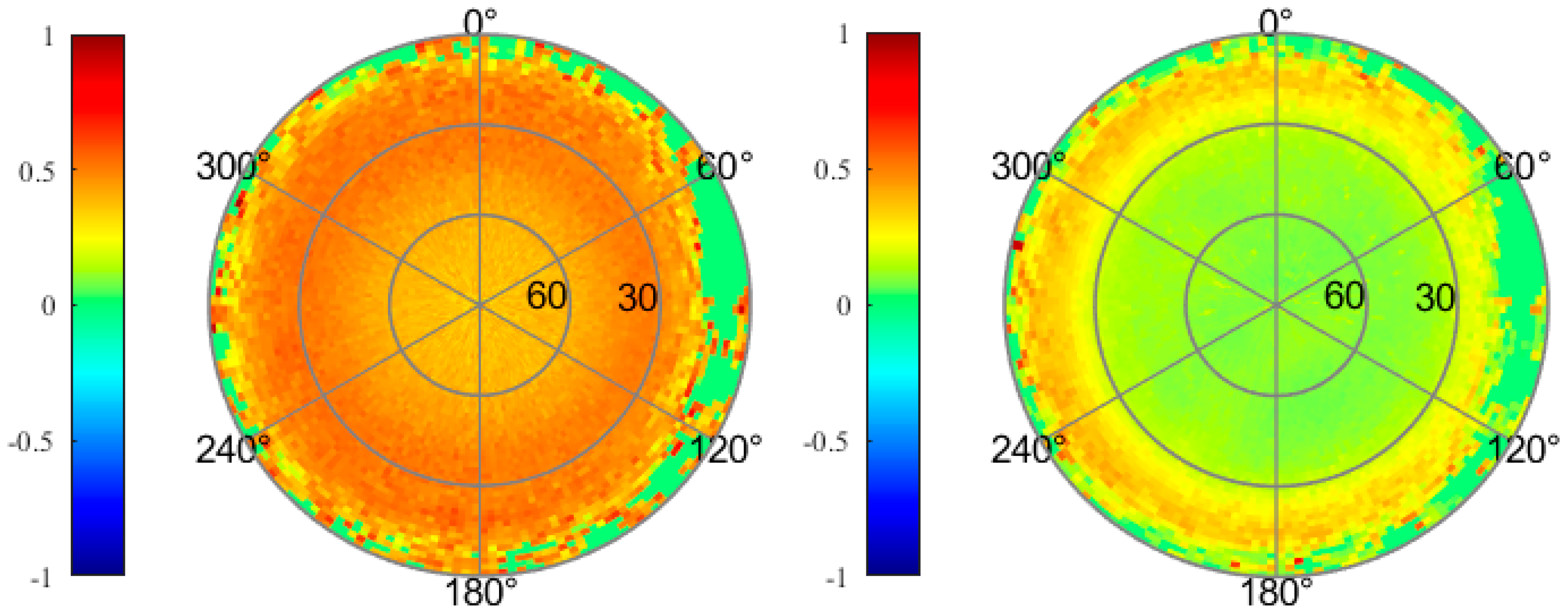
Multipath errors are closely related to antenna characteristics, receiver environments, elevation angle, etc. Figure 4 gives the distribution of the pseudo-range multipath (MP) errors for HY2D onboard GPS observation data of C1P and C2P. The magnitude of MP errors exhibits a strong correlation with the elevation angle, particularly when the elevation angle is below 30°, where multipath values fluctuate significantly; this situation often occurs during the satellite’s ingress and egress, as the satellite rapidly ascends or descends, affecting the signal. Additionally, the impact of low-elevation angles on the multipath error for C1P is more significant. Overall, the root mean square (RMS) of the MP errors for the HY2D satellite’s onboard data is approximately 0.51 m for the C1P and 0.26 m for the C2P.

3. Precise Orbit Determination Strategies

3.1. Dynamic Model of POD

The accuracy of the POD strategy is limited by the model error. Systematic errors accumulate with increasing fixed-arc length. It is common to introduce empirical force parameters or pseudo-stochastic pulses to absorb these errors [16,17,18]. This is the key to simplifying the dynamical orbit determination. Since LEO satellites operate in lower orbits subject to atmospheric drag and mechanical models are not sufficiently accurate, simplified kinetic orbit determination is widely used to compensate for the shortcomings of applied dynamic models. The influence of the dynamical model is reduced by adding process noise (usually applied in Kalman filters) or by adding “pseudo-stochastic” or “empirical” parameters (usually applied in batch least squares), and the corresponding parameters are then solved from the observation equations.
The equations of motion for LEO satellites are:
r ¨ = G M r 3 r + f t , r , r ˙ , q 1 , q 2 , , q d ,
where r , r ˙ , r ¨ represent the vectors of position, velocity, and acceleration of the LEO satellite; the initial condition is r ( k ) ( t 0 ) = r ( k ) ( a , e , i , Ω , ω , M 0 : t 0 ) , k = 0 , 1 ; the parameter a , e , i , Ω , ω , M 0 represents the six osculating Keplarian elements of the orbit at t 0 ; GM is the gravitational constant times mass of the Earth and q 1 , q 2 , , q d represents the pseudo-stochastic parameters to compensate for force modeling deficiencies. For a particular osculating element, an instantaneous velocity change is set in a pre-determined direction, which is called a pseudo-stochastic pulse. We usually set pseudo-stochastic pulses at intervals in the radial (R), transverse (T), and normal (N) directions of the orbit. Assuming that the epoch is t i and the preset direction is e ( t ) , the pseudo-random pulse parameter p i is denoted as:
p i = a i δ ( t t i ) e ( t ) ,
where δ ( t t i ) is the Dirac function, δ ( t t i ) = 1 , t = t i 0 , t t i , and its a priori value is determined by ω a i = σ 0 2 σ a i 2 . Among them, σ 0 denotes the priori weighted RMS error; σ a i denotes a priori standard deviation (STD) of pseudo-stochastic pulses. If σ a i is larger, the corresponding weight ω a i is smaller, that is to say, at this time, the pseudo-stochastic pulse can largely absorb the influence of the error of the mechanical model, and the role of the dynamical model in the trajectory is weakened. Conversely, if σ a i is small, the ω a i is larger; when the mechanical model is more accurate, the effect of pseudo-random pulses can be reduced. The corresponding variational equation is:
Y ¨ a i = A Y a i + δ t t i e t ,
where Y a i denotes the linear combination of the partial derivatives of the six orbital roots of the initial epoch; A denotes the corresponding array of coefficients; and the other parameters have the same meaning as in Equation (2).
By taking the derivative of the above equations with respect to parameter Y, we obtain the following initial value problem (variational equation and associated initial conditions which are zero for the dynamical parameters).

3.2. Maneuver Handling Strategy

At present, under the framework of simplified dynamical orbit determination, there are two main parameter modeling methods for orbital maneuvers, namely, the constant acceleration model and the velocity impulse model. The velocity impulse model is an instantaneous compensation strategy that compensates the orbital maneuver by adopting the instantaneous velocity impulse model at a certain moment, which is closer to the actual physical process for maneuvers with shorter duration, but the disadvantage is that it is difficult to accurately model the long-time maneuver. The constant-value acceleration model adopts an averaging compensation strategy, in which the velocity change generated by the orbit maneuver is expressed as the average acceleration during the maneuver duration, which can more adequately compensate for both short- and long-term maneuvers. Therefore, a methodology for modeling orbital maneuvers using the constant-value acceleration model is described below.
Based on the segmented linear empirical acceleration, the constant acceleration of the mechanical power is added, and the orbital maneuvering is modeled by using the constant acceleration α R i , α T i , and α T i in the R, T, and N directions of the track:
a m a n = i = 1 k ( α R i e R i + α T i e T i + α N i e N i ) ξ ( t , t i s , t i e ) ,
where k denotes the total number of maneuvering intervals; t i s and t i e denote the start and end times of the ith maneuver interval (known parameters from onboard telemetry data), respectively, and ξ ( t , t i s , t i e ) is equal to 1 in subinterval [ t i s , t i e ) otherwise equal to 0. The symbols e R i , e T i , and e N i represent the unit vectors of the R, T, and N directions for each specified maneuver.
The corresponding variational equation for the specified maneuver parameter α and the initial conditions can be written as:
z ¨ α t = f r z α t + f r z ˙ α t + e i ξ t , t s i , t e i z α t 0 = 0 ; z ˙ α ( t 0 ) = 0 ,
For t 0 t < t s i , Equation (5) is equivalent to a linear and homogeneous differential equation as follows:
z ¨ α t = f r z α t + f r ˙ z ˙ α t z α t 0 = 0 ; z ˙ α t 0 = 0 ,
At this point, the solution of the variational Equation (5) is constant zero. According to Equation (6), it can be seen that the moment of maneuvering t s i previous observations do not contribute to the maneuver parameter α estimates have no contribution. Even if there are no observations in the maneuver interval t s i , t e i , the maneuver parameter α can be estimated from the observations after the maneuver interval, which involves the time resolution of the numerical integration algorithm near the maneuver.
For t s i t < t e i , Equation (5) is equivalent to a linear and homogeneous differential equation as follows
z ¨ α t = f r z α t + f r ˙ z ˙ α t + e i z α t 0 = 0 ; z ˙ α t 0 = 0 ,
During this period, the solution zaðtÞ is no longer kept to zero. Since a thrust is performed on the spacecraft, the trajectory r ( t ) will be changed after epoch t s and the accumulative influence will depend on the actual burn time. The solution of (7) is crucial to the estimation of α , although the duration may be very short compared with the orbital period.
For t t e i ,
z ¨ α t = f r z α t + f r ˙ z ˙ α t z α t 0 0 ; z ˙ α t 0 0 ,
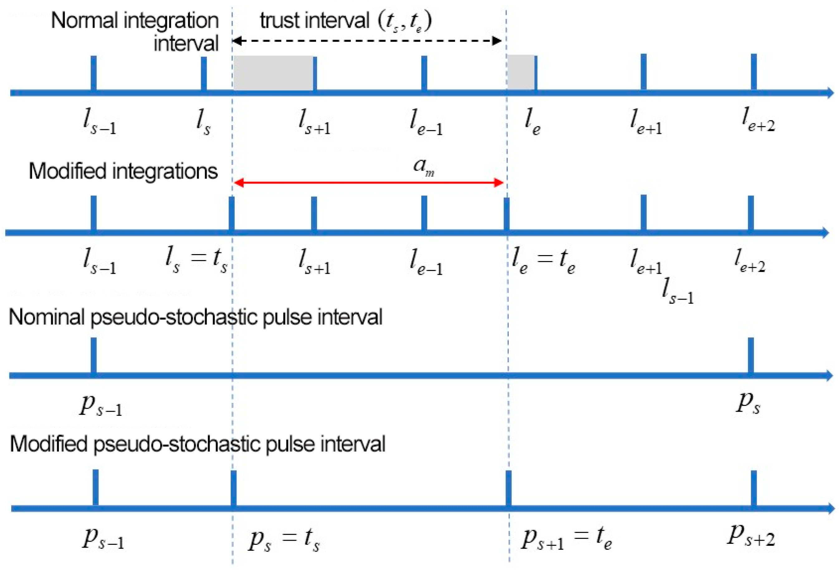
Since the start and end periods of a maneuver usually do not exactly match the predefined integration boundaries, this leads to incorrect modeling of the maneuver acceleration. Therefore, the boundaries of the two integration intervals closest to the start and end periods of the maneuver were shifted to completely cover the maneuver duration. At the same time, the boundaries of the pseudo-stochastic pulse intervals were adjusted to similarly cover the maneuver durations completely.
In the most general case, the duration of the maneuver spans several integration intervals, assuming that the integration interval is 1 min, while the pseudo-stochastic pulse interval is 6 min, and the corresponding integration interval and pseudo-stochastic pulse interval are adjusted as shown in Figure 5. The velocity change associated with each maneuver can be derived from the maneuver acceleration δ v = a m a n Δ t , where Δ t represents the thrust duration.
The detailed dynamics and measurement models used for orbit determination are summarized in Table 4. It should be noted that orbital parameters are always estimated together with non-orbital parameters (e.g., ambiguities and receiver clock offsets).

4. Results and Discussion

4.1. Analysis of POD for Maneuvering HY2D

4.1.1. Carrier Phase Residuals Analysis for Maneuvering HY2D

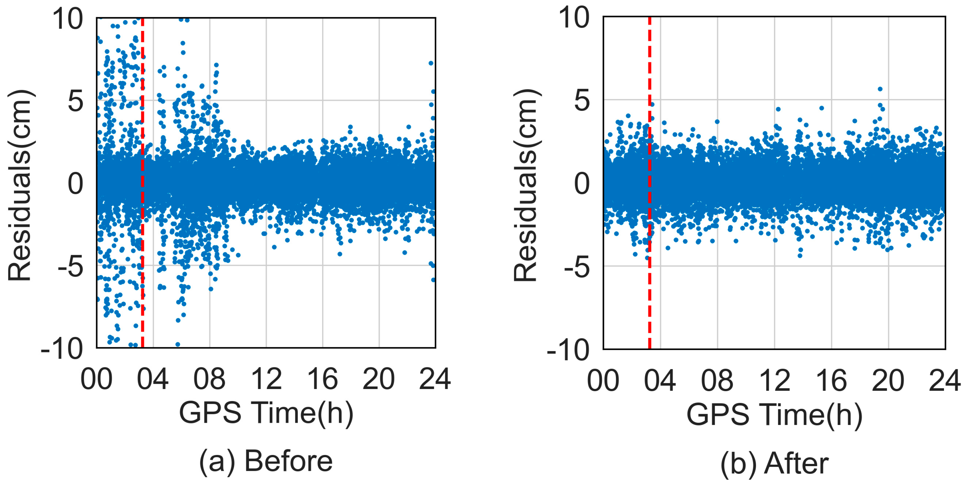
Phase residuals provide insights into the quality of orbit determination during maneuvers to a certain extent. We analyze the orbit accuracy before and after maneuver modeling using ionosphere-free carrier phase linear combination (LC) residuals. Figure 6 illustrates the LC residuals before and after the maneuver of the HY2D satellite on 15 December 2023, with the vertical line denoting the moment of maneuver. Notably, LC residuals for the POD exceeding 10 cm during the maneuver period are omitted from the figure, with the maximum residuals reaching approximately 30 cm. The comparison reveals a significant increase in LC residuals in the absence of additional maneuver acceleration compensation during the maneuver. However, with prolonged observation time as well as maneuver estimation, the LC residuals gradually decrease, although it takes some time to return to normal levels. Conversely, when maneuver acceleration parameters are properly compensated, all LC residuals remain within normal ranges.
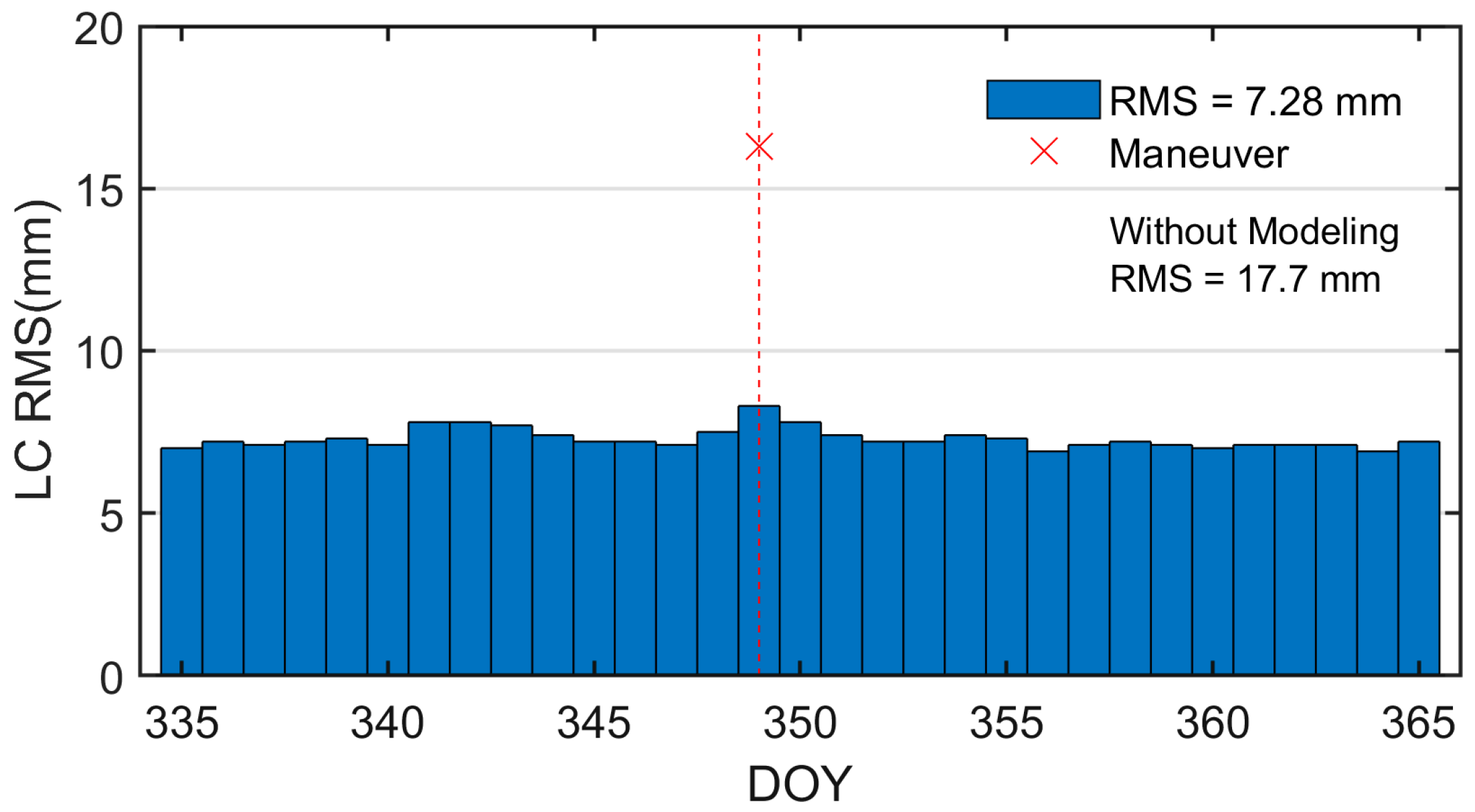
Besides, to validate the reliability of the above maneuver model strategy, Table 5 presents the RMS of the LC residuals obtained before and after utilizing the maneuver model strategy in the POD for the HY2D satellite in 2023. Additionally, the LC residuals for December 2023 are given in Figure 7. As can be seen from Figure 7 and Table 5, during the periods without maneuvers, the value of the LC residuals RMS averages around 7.2 mm. Following the processing of the maneuver on December 15, the POD residual RMS decreases from 17.7 mm to 7.9 mm, marking a notable improvement of 55.37%. Notably, maneuver modeling significantly enhances POD residuals, with the most substantial improvement observed on 8 October 2023, where the RMS of LC residuals decreased from 28.8 mm to 7.8 mm, indicating a remarkable improvement of 72.92%. Moreover, after compensating for maneuver acceleration parameters, the mean value of LC residuals for the five maneuvers decreases from 19.3 mm to 7.9 mm, effectively restoring the level observed during non-maneuver periods.

4.1.2. Maneuver Assessment by POD

Handling orbital maneuvers is important for routine POD processing, current maneuver calibration, and future maneuver planning. The efficacy of each maneuver can be gauged through analysis of the orbit determination results, providing insights into the performance of the satellite’s propulsion system. On the HY2D satellite, maneuvers are typically planned based on velocity changes (delta v) within a fixed coordinate system. Since the satellite maintains a relatively constant orientation concerning the RTN coordinate system during the thrust phase, maneuvers can be evaluated based on a comparison of the magnitude of the velocities in the maneuver files supplied by NSOAS with the velocities derived from POD. Table 6 gives the maneuver information provided by NSOAS and the velocity changes and their deviations estimated by POD. The difference indicates that the velocity changes based on onboard telemetry data are in high agreement with the results estimated from POD.

4.1.3. External Orbit Comparisons for Maneuvering HY2D

Further, the effectiveness of the maneuver modeling is verified by external precision products. Taking 15 December 2023, as an illustrative example, Figure 8 depicts the orbit radial difference sequences in the RTN system between calculated orbit before and after maneuver modeling with the precision science orbits (PSO) provided by CNES (Centre National d’Études Spatiales). In the figure, red and green denote the results before and after modeling, respectively, while the blue dotted line indicates the center of burn time. Statistical values are provided at the top of each subplot.
As can be seen from the figures, before modeling, the orbit has large fluctuations relative to the PSO for about one hour before and after the maneuver moment, especially in the tangential direction, where the deviation is up to 1.1 m. In addition, the radial direction also has large fluctuations, while the normal direction is relatively less affected by the maneuver. Maneuver modeling led to a reduction in the RMS differences in the three directions relative to the PSO, decreasing to 2.38 cm, 5.69 cm, and 3.48 cm, respectively. This resulted in a significant enhancement in orbital accuracy, with the most notable improvement observed in the tangential direction, directly influenced by the direction of the thruster force.
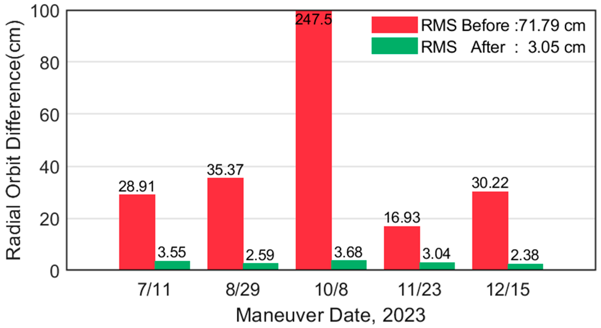
Besides, Figure 9 displays the RMS of the radial differences between the HY2D satellite orbit and PSO before and after processing maneuver model strategy in 2023 for five maneuvers. Maneuver modeling notably enhanced the results of external orbital validation. Notably, on 8 October 2023, the T component exhibited the most significant improvement, with the RMS residual decreasing from 247.5 cm to 3.68 cm, representing an enhancement of 98.51%. Orbital accuracy on each day during the experimental period essentially reverted to maneuver-free levels, with post-processing orbit differences averaging RMS values of 3.04 cm in the R, 8.78 cm in the T, and 2.72 cm in the N directions.

4.2. Orbit Validation and Analysis

In this section, the accuracy of the December 2023 HY2D orbit determination is checked and analyzed under maneuver handling conditions. The checking methods include a 6-h overlap comparison, a comparison with PSO provided by CNES, and SLR range validation.

4.2.1. Overlap Comparison

In this paper, the length of the orbit determination arc segment is set as 30 h, spanning from 21:00 the previous day to 03:00 the following day, with a 6-h overlap between adjacent arcs. This arrangement facilitated the internal consistency check of the orbit through comparison of overlapping arcs. Figure 10 gives the differences of 6 h overlap arc segments of HY2D satellite in December 2023. During the non-maneuver periods, the average value of RMS of radial difference of overlapping arc is 0.66 cm, and the difference of the three-dimensional (3D) position is about 1.16 cm. Conversely, during maneuvers, the differences were slightly larger, with the radial and 3D averaging 1.43 cm and 3.25 cm, respectively.

4.2.2. Comparison with Precision Science Orbits

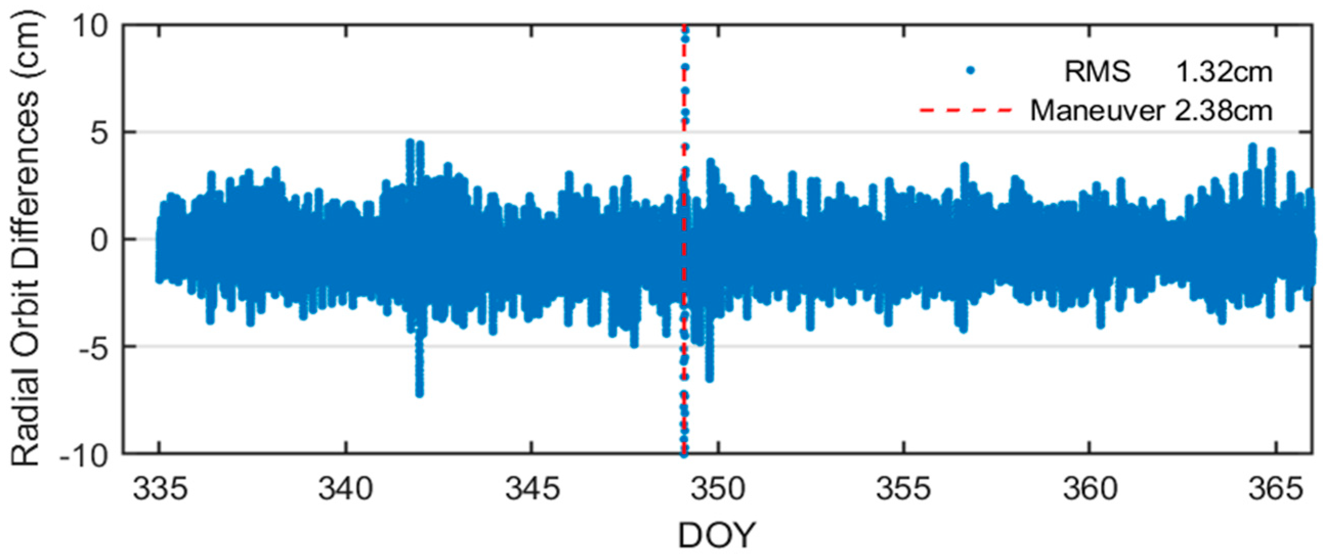
We further compare the computed orbits with the PSO provided by CNES, and the mean RMS of the differences in R, T, N, and 3D positions from the CNES standard orbital differences are 1.32, 2.31, 2.17, and 3.53 cm, respectively. As an ocean altimetry mission, the orbit differences in the radial direction are our foremost concern; the radial differences from the PSO are given in Figure 11. During the maneuver periods, the RMS of the radial differences between the two orbits was slightly larger than during non-maneuver periods, amounting to 2.38 cm. Furthermore, Table 7 gives the orbit difference statistics for both periods in R, T, N.

4.2.3. SLR Range Validation

For LEO satellites installed with SLR reflectors, SLR observations can be used as an independent measurement to check the orbit alignment accuracy due to its high measurement accuracy.
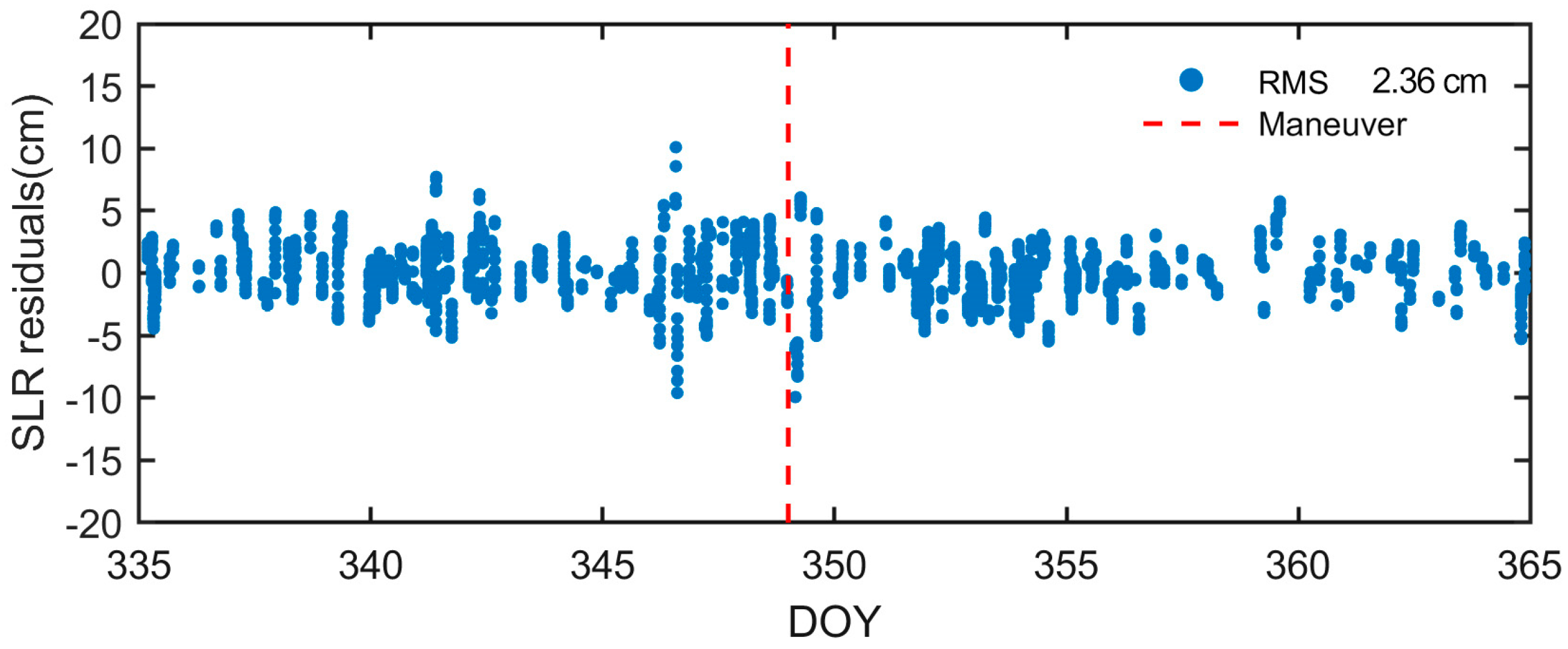
During the experimental period, there were 28 SLR stations tracked by HY2D, and 3723 NP data were obtained. Considering that the standard point accuracy of the core station is 5~10 mm [26], this paper adopts the core station to check the orbit, and the interstellar altitude angle of the data point station is more than 20 degrees; 2131 NP data is used in validation. The distribution of SLR validation residuals for HY2D in December 2023 is shown in Figure 12. The results show that the overall SLR checking residual RMS is better than 3 cm, and the orbit has good external checking accuracy.

5. Conclusions

This paper addresses the issue of maneuver handling in non-differential reduced-dynamics orbit determination based on onboard GNSS data for the HY2D satellite. It includes an analysis of the satellite’s onboard GNSS data quality and establishes a thrust model based on pseudo-stochastic pulses to evaluate the differences between pre- and post-maneuver orbit determination results, as detailed below:
(1)
The on-board GNSS receiver demonstrates a strong tracking capability, with the number of satellites tracked per epoch ranging from 4 to 9, with an average of 6.4, and its code and phase observation data are of high quality.
(2)
In December 2023, during periods without satellite maneuvers, the average value of the RMS of the LC residuals is 0.7 cm; the average value of the RMS of the radial difference of the overlapping arc segments of the two adjacent days of 6 h is 0.66 cm; the difference of the 3D position is about 1.16 cm; the average RMS of the differences with the CNES standard orbital differences in the R, T, N, and 3D positions is 1.32 cm, 2.31 cm, 2.17 cm, and 3.53 cm, respectively.
(3)
The study selects five maneuver days in the second half of 2023 to validate the effect of the maneuver model strategy. The results show that maneuver handling can avoid precision degradation. For example, through the maneuvering treatment, the POD residuals are reduced from the original 1.93 cm to 0.79 cm, the orbit differences with PSO are reduced from the decimeter level or even the meter level to the centimeter level, and the average values of the R, T, and N differences of the orbit differences after maneuver handling are 3.04 cm, 8.78 cm, and 2.72 cm, respectively.
(4)
Using the global SLR core station data with an inter-station altitude angle greater than 20 degrees, the orbital accuracy in December 2023 (including the maneuver on December 15) is evaluated. The RMS of SLR residual differences in the ranging direction is 2.24 cm, indicating the effectiveness of the maneuver handling strategy and the significant improvement in orbit determination accuracy.

Author Contributions

K.X. prepared formal analysis and original draft preparation; resources, H.P.; data curation, X.W.; writing—review and editing, X.Z.; formal analysis, F.G.; validation and funding acquisition, K.L. All authors have read and agreed to the published version of the manuscript.

Funding

The authors acknowledge the data assistance provided by the National Satellite Ocean Application Center. This research was funded by the National Natural Science Foundation of China, grant number 12103077.

Data Availability Statement

The HY2D data presented in this study are available on request from the corresponding author. The data are not publicly available due to institutional data sharing policies.

Acknowledgments

The ILRS and CDDIS are acknowledged for providing SLR tracking data and orbit products. Thanks a lot to the National Satellite Ocean Application Service for providing the HY2D onboard GNSS data.

Conflicts of Interest

The authors declare no conflicts of interest.

References

  1. Antony, J.W.; Gonzalez, J.H.; Schwerdt, M.; Bachmann, M.; Krieger, G.; Zink, M. Results of the TanDEM-X Baseline Calibration. IEEE J. Sel. Top. Appl. Earth Obs. Remote Sens. 2013, 6, 1495–1501. [Google Scholar] [CrossRef]
  2. Tapley, B.D. Gravity Model Determination from the GRACE Mission. J. Astronaut. Sci. 2008, 56, 273–285. [Google Scholar] [CrossRef]
  3. Jiang, K.; Li, M.; Zhao, Q.; Li, W.; Guo, X. BeiDou Geostationary Satellite Code Bias Modeling Using Fengyun-3C Onboard Measurements. Sensors 2017, 17, 2460. [Google Scholar] [CrossRef]
  4. Kang, Z.; Bettadpur, S.; Nagel, P.; Save, H.; Poole, S.; Pie, N. GRACE-FO Precise Orbit Determination and Gravity Recovery. J. Geod. 2020, 94, 85. [Google Scholar] [CrossRef]
  5. Fernández, M.; Aguilar, J.; Fernández, J. Sentinel-3 Properties for GPS POD, Copernicus Sentinel-1,-2 and-3 Precise Orbit Determination Service (SENTINELSPOD); GMV-GMESPOD-TN-0027, Version 1.7. 2019. Available online: https://sentinel.esa.int/documents/247904/322310/GMV-GMESPOD-TN-0027_v1.8_Sentinel-3+properties+for+GPS+POD.pdf/dda5b84b-6422-482b-a78c-a71e70679e9e (accessed on 29 June 2024).
  6. Jäggi, A.; Dahle, C.; Arnold, D.; Bock, H.; Meyer, U.; Beutler, G.; van Den Ijssel, J. Swarm Kinematic Orbits and Gravity Fields from 18 Months of GPS Data. Adv. Space Res. 2016, 57, 218–233. [Google Scholar] [CrossRef]
  7. Montenbruck, O.; Gill, E.; Lutze, F. Satellite Orbits: Models, Methods, and Applications. Appl. Mech. Rev. 2002, 55, B27–B28. [Google Scholar] [CrossRef]
  8. Peng, H.; Zhou, C.; Zhong, S.; Peng, B.; Zhou, X.; Yan, H.; Zhang, J.; Han, J.; Guo, F.; Chen, R. Analysis of Precise Orbit Determination for the HY2D Satellite Using Onboard GPS/BDS Observations. Remote Sens. 2022, 14, 1390. [Google Scholar] [CrossRef]
  9. Kecai, J.; Wenwen, L.; Min, L.; Jianghui, G.; Haixia, L.; Qile, Z.; Jingnan, L. Precise orbit determination of Haiyang-2D using onboard BDS-3 B1C/B2a observations with ambiguity resolution. Satell. Navig. 2023, 4, 28. [Google Scholar]
  10. Jäggi, A.; Montenbruck, O.; Moon, Y.; Wermuth, M.; König, R.; Michalak, G.; Bock, H.; Bodenmann, D. Inter-Agency Comparison of TanDEM-X Baseline Solutions. Adv. Space Res. 2012, 50, 260–271. [Google Scholar] [CrossRef]
  11. Zhang, H.; Gu, D.; Ju, B.; Shao, K.; Yi, B.; Duan, X.; Huang, Z. Precise Orbit Determination and Maneuver Assessment for TH-2 Satellites Using Spaceborne GPS and BDS2 Observations. Remote Sens. 2021, 13, 5002. [Google Scholar] [CrossRef]
  12. Allende-Alba, G.; Montenbruck, O.; Ardaens, J.-S.; Wermuth, M.; Hugentobler, U. Estimating Maneuvers for Precise Relative Orbit Determination Using GPS. Adv. Space Res. 2017, 59, 45–62. [Google Scholar] [CrossRef]
  13. Ju, B.; Gu, D.; Herring, T.A.; Allende-Alba, G.; Montenbruck, O.; Wang, Z. Precise Orbit and Baseline Determination for Maneuvering Low Earth Orbiters. GPS Solut. 2017, 21, 53–64. [Google Scholar] [CrossRef]
  14. Kai, S.; Houzhe, Z.; Xianping, Q.; Zhiyong, H.; Bin, Y.; Defeng, G. Precise Absolute and Relative Orbit Determination for Distributed InSAR Satellite System. Acta Geod. Cartogr. Sin. 2021, 50, 580. [Google Scholar]
  15. Mao, X.; Arnold, D.; Kalarus, M.; Padovan, S.; Jäggi, A. GNSS-Based Precise Orbit Determination for Maneuvering LEO Satellites. GPS Solut. 2023, 27, 147. [Google Scholar] [CrossRef]
  16. Beutler, G.; Jäggi, A.; Hugentobler, U.; Mervart, L. Efficient Satellite Orbit Modelling Using Pseudo-Stochastic Parameters. J. Geod. 2006, 80, 353–372. [Google Scholar] [CrossRef]
  17. Zhu, S.; Reigber, C.; König, R. Integrated Adjustment of CHAMP, GRACE, and GPS Data. J. Geod. 2004, 78, 103–108. [Google Scholar] [CrossRef]
  18. Dach, R.; Walser, P. Bernese GNSS Software Version 5.2; University of Bern: Bern, Switzerland, 2015. [Google Scholar]
  19. Pavlis, N.K.; Holmes, S.A.; Kenyon, S.C.; Factor, J.K. The Development and Evaluation of the Earth Gravitational Model 2008 (EGM2008). J. Geophys. Res. Solid Earth 2012, 117, B04406. [Google Scholar] [CrossRef]
  20. Lyard, F.H.; Allain, D.J.; Cancet, M.; Carrère, L.; Picot, N. FES2014 Global Ocean Tide Atlas: Design and Performance. Ocean Sci. 2021, 17, 615–649. [Google Scholar] [CrossRef]
  21. Petit, G.; Luzum, B. IERS Conventions. IERS Tech. Note 2010, 36, 2010. [Google Scholar]
  22. Folkner, W.M.; Williams, J.G.; Boggs, D.H. The Planetary and Lunar Ephemeris DE 421. IPN Prog. Rep. 2009, 42, 1. [Google Scholar]
  23. Bizouard, C.; Lambert, S.; Gattano, C.; Becker, O.; Richard, J.-Y. The IERS EOP 14C04 Solution for Earth Orientation Parameters Consistent with ITRF 2014. J. Geod. 2019, 93, 621–633. [Google Scholar] [CrossRef]
  24. Rodriguez-Solano, C.; Hugentobler, U.; Steigenberger, P. Adjustable box-wing model for solar radiation pressure impacting GPS satellites. Adv. Space Res. 2012, 49, 1113–1128. [Google Scholar] [CrossRef]
  25. Berger, C.; Biancale, R.; Barlier, F. Improvement of the empirical thermospheric model DTM: DTM94–a comparative review of various temporal variations and prospects in space geodesy applications. J. Geod. 1998, 72, 161–178. [Google Scholar] [CrossRef]
  26. Arnold, D.; Montenbruck, O.; Hackel, S.; Sośnica, K. Satellite Laser Ranging to Low Earth Orbiters: Orbit and Network Validation. J. Geod. 2019, 93, 2315–2334. [Google Scholar] [CrossRef]
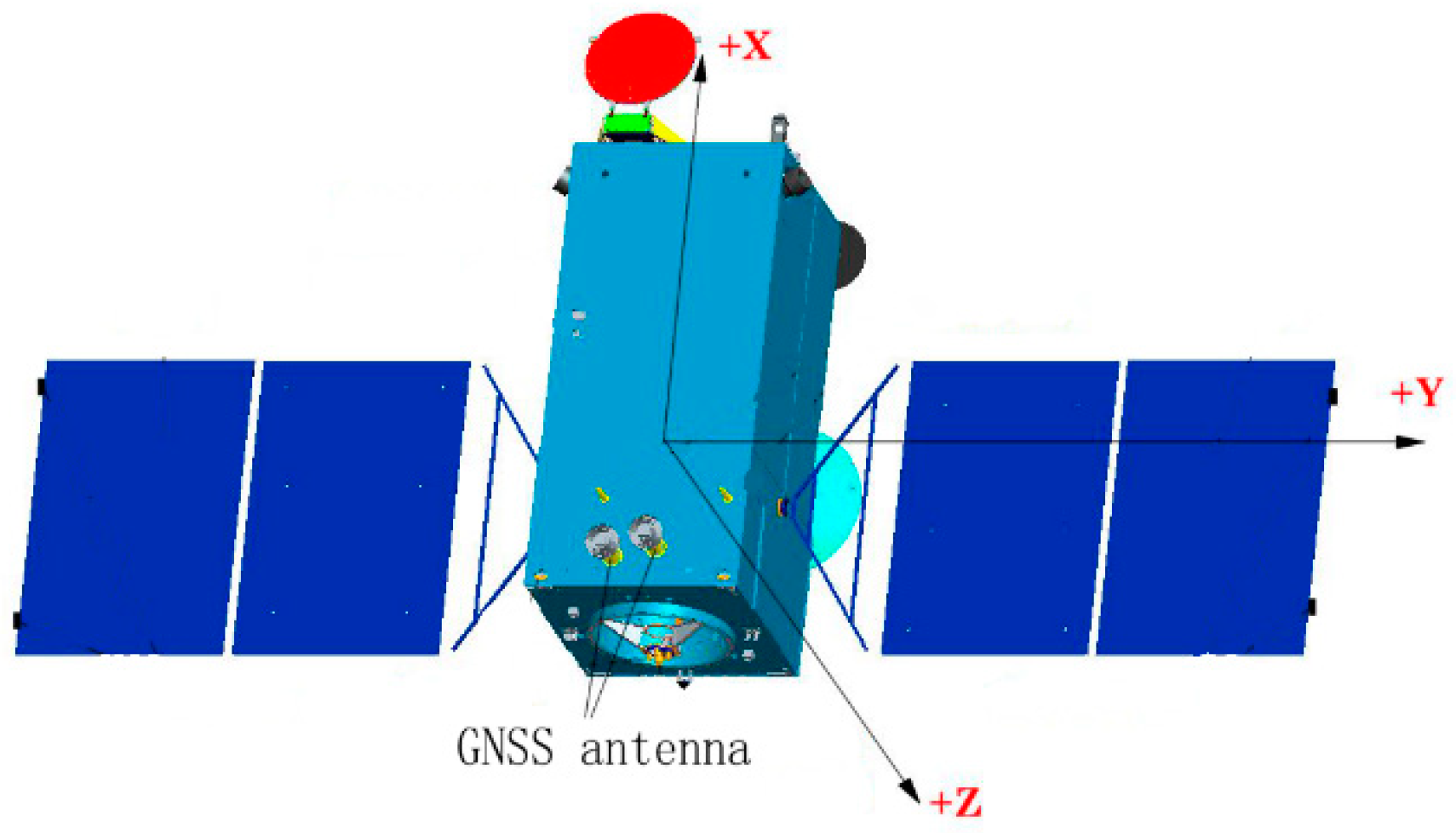
Figure 1. Visualization of the HY-2D satellite.
Remotesensing 16 02410 g001
Figure 2. Motorization information file provided by NSOAS.
Remotesensing 16 02410 g002
Figure 3. The average number of observable satellites and the percentage of effective epochs observable by the HY2D satellite in December 2023.
Remotesensing 16 02410 g003
Figure 4. Sky-Plots of MP for HY2D Code Observations C1P, C2P.
Remotesensing 16 02410 g004
Figure 5. Comparison between the nominal and the modified orbit integrations (gray blocks show the mis-modeling of maneuver) and pseudo-stochastic pulse.
Remotesensing 16 02410 g005
Figure 6. Ionospheric-free phase residuals without maneuver modeling (a) versus those with maneuver modeling (b) for HY2D on 15 December 2023. The vertical bar indicates the center of burn time.
Remotesensing 16 02410 g006
Figure 7. LC residuals for HY2D in December 2023 (DOY 335–365). The vertical bar indicates the date of the maneuver.
Remotesensing 16 02410 g007
Figure 8. Comparison with CNES POE orbit without maneuver modeling versus those with maneuver modeling for HY2D on 15 December 2023. The blue dotted line indicates the center of burn time.
Remotesensing 16 02410 g008
Figure 9. The radial orbit difference RMS with CNES PSO before and after utilizing the maneuver model strategy in the POD for HY2D.
Remotesensing 16 02410 g009
Figure 10. Comparison with CNES PSO orbit without maneuver modeling versus those with maneuver modeling for HY2D on 15 December 2023.
Remotesensing 16 02410 g010
Figure 11. Radial orbit difference compared with CNES for HY2D in December 2023.
Remotesensing 16 02410 g011
Figure 12. Distribution of SLR Validation Residuals for HY2D (the vertical bar indicates the Maneuver).
Remotesensing 16 02410 g012
Table 1. HY2D coordinates of the COM, GNSS antenna phase center and LRA (laser retro-array) spherical center in SBF.
Item X (mm)Y (mm)Z (mm)
COM location1319.4−4.75.7
GPS phase center347.4−181.0−1396.1
LRA spherical center311.7−215.51060.8
Table 2. Data sources.
DataOrganizationRelated Addresses
On-board GPS observation data (1 s)NSOAShttps://osdds.nsoas.org.cn (accessed on 29 June 2024)
On-board attitude angle data (1 s)NSOAShttps://osdds.nsoas.org.cn (accessed on 29 June 2024)
GPS precise ephemeris (15 min)CODEhttp://ftp.aiub.unibe.ch/CODE (accessed on 29 June 2024)
GPS precise clock file (30 s)CODEhttp://ftp.aiub.unibe.ch/CODE (accessed on 29 June 2024)
Earth rotation parametersCODEhttp://ftp.aiub.unibe.ch/CODE (accessed on 29 June 2024)
HY2D precision orbit file (1 min)CNEShttps://ids-doris.org (accessed on 29 June 2024)
SLR observation data filesNASAhttps://cddis.nasa.gov/archive/slr (accessed on 29 June 2024)
Table 3. HY2D maneuvering information in 2023.
Serial NumberDate of
Motorization
Day of the Year (DOY)Start Time (UTC)Duration (s)Number of Thrusters
111 July 202319203:40:37.06.9461
229 August 202324103:00:37.05.7781
38 October 202328108:45:37.09.4181
423 November 202332701:40:37.05.6881
515 December 202334903:15:37.06.2441
Table 4. Summary of the POD strategy used for the HY-2D satellite.
TypeModel/ParametersDescription
Dynamic modelGravity modelEGM2008 [19]
Ocean tideFES2014 [20]
Solid Earth tideIERS 2010 Conventions [21]
N-body perturbationJPL DE421 [22]
Earth orientationIERS C04 [23]
RelativityIERS 2010 Conventions [21]
Solar radiationBox-Wing [24]
Atmosphere dragDTM94 [25]
Empirical forceOne-cycle-per-revolution acceleration (sine and cosine terms) in along-track and cross-track;
Observation modelObservationL1L2
Arc length and interval30 h, 30 s
Elevation cut-off angle (°)
Precise ephemeris and clockCODE precise final products
GPS antenna PCO/PCVIGS14.atx
Estimated parametersInitial statePosition and velocity at the initial epoch
Receiver clock offsetEpoch-wise clock offsets
Phase ambiguitiesFloat
Pseudo-stochastic pulsesOne estimate every 15 min
Maneuver accelerationsEstimated during the period of maneuver
Table 5. LC RMS obtained before and after utilizing the maneuver model strategy in the POD for HY2D satellite in 2023.
DatesDOYBefore Modeling (mm)After Modeling (mm)Improvement
11 July 202319216.67.256.63%
29 August 202324118.29.150.00%
8 October 202328128.87.872.92%
23 November 202332715.27.451.32%
15 December 202334917.77.955.37%
Table 6. Maneuver corresponding velocity changes derived by POD of HY-2D.
Date Maneuver Information Delta v (m/s)Solution Delta v (m/s)Difference
11 July 20231.25 × 10−21.24 × 10−20.80%
29 August 20231.02 × 10−20.94 × 10−27.84%
8 October 20231.68 × 10−21.80 × 10−27.14%
23 November 20231.11 × 10−20.90 × 10−218.92%
15 December 20231.11 × 10−21.12 × 10−20.90%
Table 7. Orbit difference statistics for maneuver and non-maneuver periods for HY2D in December 2023.
PeriodsR (cm)T (cm)N (cm)
maneuver2.385.893.48
non-maneuver1.322.313.53
Disclaimer/Publisher’s Note: The statements, opinions and data contained in all publications are solely those of the individual author(s) and contributor(s) and not of MDPI and/or the editor(s). MDPI and/or the editor(s) disclaim responsibility for any injury to people or property resulting from any ideas, methods, instructions or products referred to in the content.