UAV-Spherical Data Fusion Approach to Estimate Individual Tree Carbon Stock for Urban Green Planning and Management
Abstract
1. Introduction
2. Materials and Methods
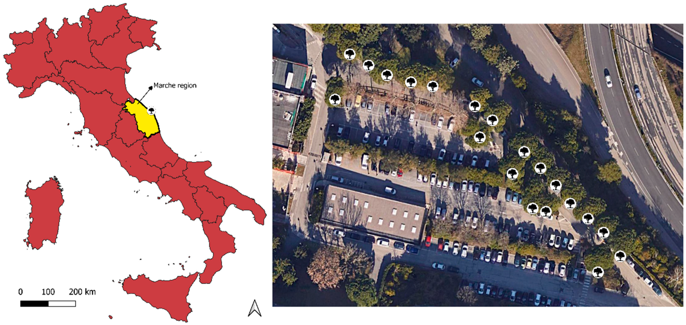
2.1. Study Area
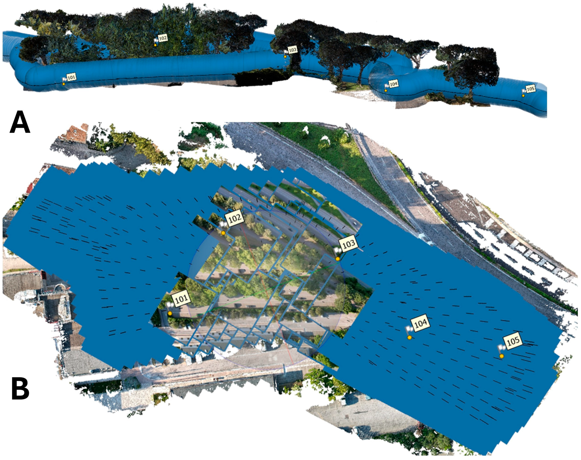
2.2. Data Acquisition
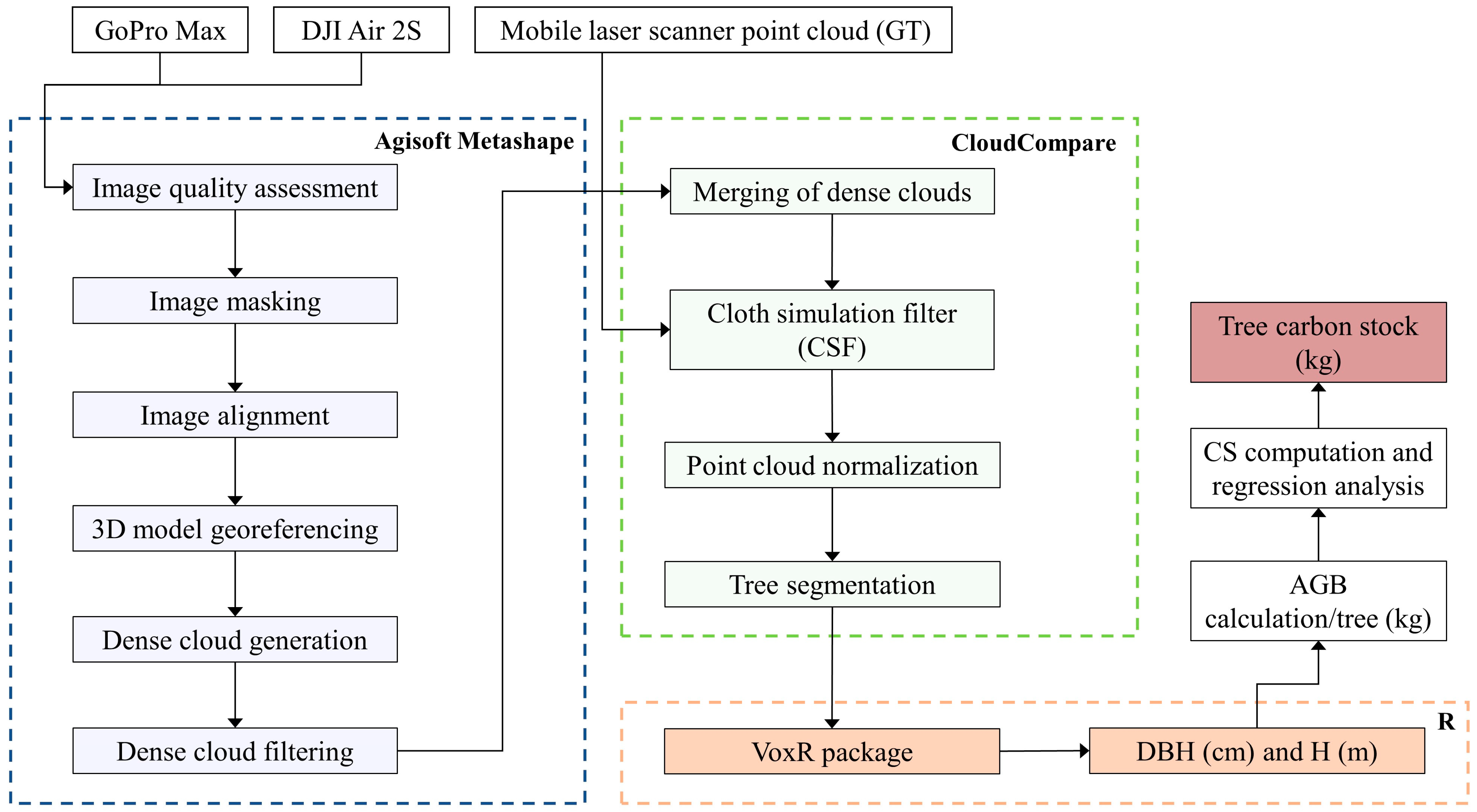
2.3. Data Processing
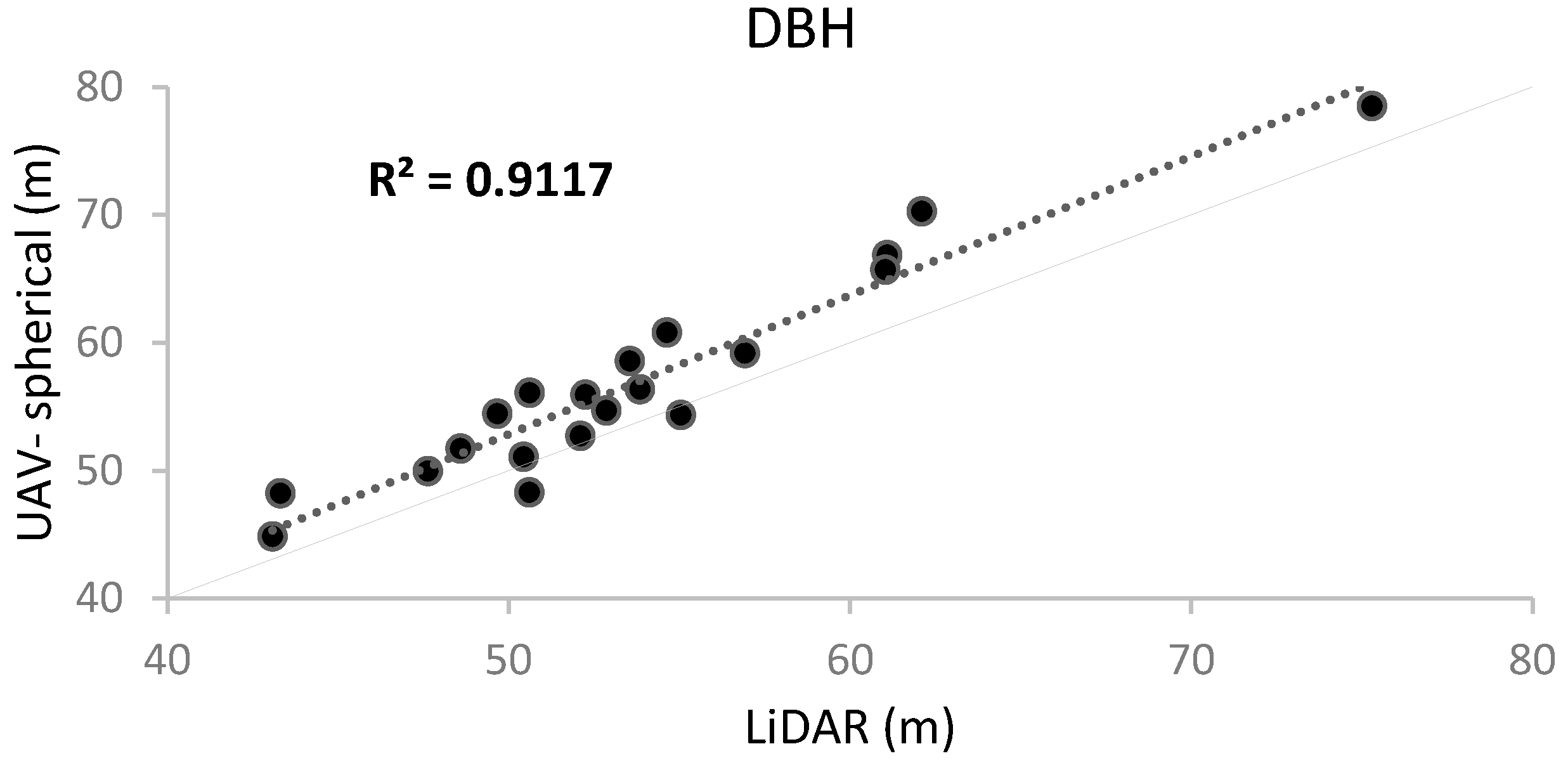
3. Results
4. Discussion
5. Conclusions
Author Contributions
Funding
Data Availability Statement
Conflicts of Interest
References
- Nowak, D.J.; Crane, D.E. Carbon storage and sequestration by urban trees in the USA. Environ. Pollut. 2002, 116, 381–389. [Google Scholar] [CrossRef] [PubMed]
- Haase, D.; Güneralp, B.; Dahiya, B.; Bai, X.; Elmqvist, T. Global urbanization. Urban Planet Knowl. Towar. Sustain. Cities 2018, 19, 326–339. [Google Scholar]
- Puplampu, D.A.; Boafo, Y.A. Exploring the impacts of urban expansion on green spaces availability and delivery of ecosystem services in the Accra metropolis. Environ. Chall. 2021, 5, 100283. [Google Scholar] [CrossRef]
- Ribeiro, H.V.; Rybski, D.; Kropp, J.P. Effects of changing population or density on urban carbon dioxide emissions. Nat. Commun. 2019, 10, 3204. [Google Scholar] [CrossRef]
- Suwardhi, D.; Fauzan, K.N.; Harto, A.B.; Soeksmantono, B.; Virtriana, R.; Murtiyoso, A. 3D Modeling of Individual Trees from LiDAR and Photogrammetric Point Clouds by Explicit Parametric Representations for Green Open Space (GOS) Management. ISPRS Int. J. Geo-Inf. 2022, 11, 174. [Google Scholar] [CrossRef]
- Baines, O.; Wilkes, P.; Disney, M. Quantifying urban forest structure with open-access remote sensing data sets. Urban For. Urban Green. 2020, 50, 126653. [Google Scholar] [CrossRef]
- Doick, K.J.; Davies, H.J.; Moss, J.; Coventry, R.; Handley, P.; VazMonteiro, M.; Rogers, K.; Simpkin, P. The Canopy Cover of England’s Towns and Cities: Baselining and setting targets to improve human health and well-being. In Proceedings of the Trees, People and the Built Environment III, International Urban Trees Research Conference, Birmingham, UK, 3–14 April 2011; University of Birmingham: Birmingham, UK, 2017; pp. 5–6. [Google Scholar]
- Jo, H.-K.; Kim, J.-Y.; Park, H.-M. Carbon reduction and planning strategies for urban parks in Seoul. Urban For. Urban Green. 2019, 41, 48–54. [Google Scholar] [CrossRef]
- Kanniah, K.D.; Muhamad, N.; Kang, C.S. Remote sensing assessment of carbon storage by urban forest. IOP Conf. Ser. Earth Environ. Sci. 2014, 18, 12151. [Google Scholar] [CrossRef]
- Rosenfeld, A.H.; Akbari, H.; Romm, J.J.; Pomerantz, M. Cool communities: Strategies for heat island mitigation and smog reduction. Energy Build. 1998, 28, 51–62. [Google Scholar] [CrossRef]
- Nowak, D.J.; Greenfield, E.J.; Hoehn, R.E.; Lapoint, E. Carbon storage and sequestration by trees in urban and community areas of the United States. Environ. Pollut. 2013, 178, 229–236. [Google Scholar] [CrossRef]
- McPherson, E.G. Carbon Dioxide Reduction through Urban Forestry: Guidelines for Professional and Volunteer Tree Planters; US Department of Agriculture, Forest Service, Pacific Southwest Research Station: Placerville, CA, USA, 1999; Volume 171. [Google Scholar]
- Lin, J.; Chen, D.; Wu, W.; Liao, X. Estimating aboveground biomass of urban forest trees with dual-source UAV acquired point clouds. Urban For. Urban Green. 2022, 69, 127521. [Google Scholar] [CrossRef]
- Penman, J.; Gytarsky, M.; Hiraishi, T.; Krug, T.; Kruger, D.; Pipatti, R.; Buendia, L.; Miwa, K.; Ngara, T.; Tanabe, K. Good practice guidance for land use, land-use change and forestry. In Good Practice Guidance for Land Use, Land-Use Change and Forestry; IPCC: Geneva, Switzerland, 2003. [Google Scholar]
- Li, X.; Chen, W.Y.; Sanesi, G.; Lafortezza, R. Remote sensing in urban forestry: Recent applications and future directions. Remote Sens. 2019, 11, 1144. [Google Scholar] [CrossRef]
- Song, Y.; Imanishi, J.; Sasaki, T.; Ioki, K.; Morimoto, Y. Estimation of broad-leaved canopy growth in the urban forested area using multi-temporal airborne LiDAR datasets. Urban For. Urban Green. 2016, 16, 142–149. [Google Scholar] [CrossRef]
- Cabo, C.; Del Pozo, S.; Rodríguez-Gonzálvez, P.; Ordóñez, C.; González-Aguilera, D. Comparing terrestrial laser scanning (TLS) and wearable laser scanning (WLS) for individual tree modeling at plot level. Remote Sens. 2018, 10, 540. [Google Scholar] [CrossRef]
- Calders, K.; Adams, J.; Armston, J.; Bartholomeus, H.; Bauwens, S.; Bentley, L.P.; Chave, J.; Danson, F.M.; Demol, M.; Disney, M.; et al. Terrestrial laser scanning in forest ecology: Expanding the horizon. Remote Sens. Environ. 2020, 251, 112102. [Google Scholar] [CrossRef]
- Shao, T.; Qu, Y.; Du, J. A low-cost integrated sensor for measuring tree diameter at breast height (DBH). Comput. Electron. Agric. 2022, 199, 107140. [Google Scholar] [CrossRef]
- Hyyppä, E.; Yu, X.; Kaartinen, H.; Hakala, T.; Kukko, A.; Vastaranta, M.; Hyyppä, J. Comparison of backpack, handheld, under-canopy UAV, and above-canopy UAV laser scanning for field reference data collection in boreal forests. Remote Sens. 2020, 12, 3327. [Google Scholar] [CrossRef]
- Tao, W.; Lei, Y.; Mooney, P. Dense point cloud extraction from UAV captured images in forest area. In Proceedings of the 2011 IEEE International Conference on Spatial Data Mining and Geographical Knowledge Services, Fuzhou, China, 29 June–1 July 2011; IEEE: Piscataway, NJ, USA, 2011; pp. 389–392. [Google Scholar]
- Yang, W.; Liu, Y.; He, H.; Lin, H.; Qiu, G.; Guo, L. Airborne LiDAR and Photogrammetric Point Cloud Fusion for Extraction of Urban Tree Metrics According to Street Network Segmentation. IEEE Access 2021, 9, 97834–97842. [Google Scholar] [CrossRef]
- Akpo, H.A.; Atindogbé, G.; Obiakara, M.C.; Adjinanoukon, A.B.; Gbedolo, M.; Fonton, N.H. Accuracy of common stem volume formulae using terrestrial photogrammetric point clouds: A case study with savanna trees in Benin. J. For. Res. 2021, 32, 2415–2422. [Google Scholar] [CrossRef]
- Fekry, R.; Yao, W.; Cao, L.; Shen, X. Ground-based/UAV-LiDAR data fusion for quantitative structure modeling and tree parameter retrieval in subtropical planted forest. For. Ecosyst. 2022, 9, 100065. [Google Scholar] [CrossRef]
- SADEGHIAN, H.; Naghavi, H.; Maleknia, R.; Soosani, J.; Pfeifer, N. Estimating the attributes of urban trees using terrestrial photogrammetry. Environ. Monit. Assess. 2022, 194, 625. [Google Scholar] [CrossRef] [PubMed]
- Mokroš, M.; Výbošťok, J.; Grznárová, A.; Bošela, M.; Šebeň, V.; Merganič, J. Non-destructive monitoring of annual trunk increments by terrestrial structure from motion photogrammetry. PLoS ONE 2020, 15, e0230082. [Google Scholar] [CrossRef] [PubMed]
- Moreno, G.; Martínez Carretero, E.; Vázquez, J.; Vento, B.; Ontivero, M.; Duplancic, A.; Alcalá, J. Quantifying the role of Platanus hispanica in carbon storage in an urban forest in central west Argentina. Arboric. J. 2023, 45, 118–131. [Google Scholar] [CrossRef]
- Schreyer, J.; Tigges, J.; Lakes, T.; Churkina, G. Using airborne LiDAR and QuickBird data for modelling urban tree carbon storage and its distribution-a case study of Berlin. Remote Sens. 2014, 6, 10636–10655. [Google Scholar] [CrossRef]
- Strohbach, M.W.; Haase, D. Above-ground carbon storage by urban trees in Leipzig, Germany: Analysis of patterns in a European city. Landsc. Urban Plan. 2012, 104, 95–104. [Google Scholar] [CrossRef]
- Miller, J.; Morgenroth, J.; Gomez, C. 3D modelling of individual trees using a handheld camera: Accuracy of height, diameter and volume estimates. Urban For. Urban Green. 2015, 14, 932–940. [Google Scholar] [CrossRef]
- Panagiotidis, D.; Surový, P.; Kuželka, K. Accuracy of Structure from Motion models in comparison with terrestrial laser scanner for the analysis of DBH and height influence on error behaviour. J. For. Sci. 2016, 62, 357–365. [Google Scholar] [CrossRef]
- Choi, K.; Lim, W.; Chang, B.; Jeong, J.; Kim, I.; Park, C.-R.; Ko, D.W. An automatic approach for tree species detection and profile estimation of urban street trees using deep learning and Google street view images. Isprs J. Photogramm. Remote Sens. 2022, 190, 165–180. [Google Scholar] [CrossRef]
- Tabacchi, G.; Di Cosmo, L.; Gasparini, P. Aboveground tree volume and phytomass prediction equations for forest species in Italy. Eur. J. For. Res. 2011, 130, 911–934. [Google Scholar] [CrossRef]
- Guerra-Hernández, J.; Cosenza, D.N.; Rodriguez, L.C.E.; Silva, M.; Tomé, M.; Díaz-Varela, R.A.; González-Ferreiro, E. Comparison of ALS-and UAV (SfM)-derived high-density point clouds for individual tree detection in Eucalyptus plantations. Int. J. Remote Sens. 2018, 39, 5211–5235. [Google Scholar] [CrossRef]
- Lian, X.; Zhang, H.; Xiao, W.; Lei, Y.; Ge, L.; Qin, K.; He, Y.; Dong, Q.; Li, L.; Han, Y. Biomass Calculations of Individual Trees Based on Unmanned Aerial Vehicle Multispectral Imagery and Laser Scanning Combined with Terrestrial Laser Scanning in Complex Stands. Remote Sens. 2022, 14, 4715. [Google Scholar] [CrossRef]
- Lee, J.-H.; Ko, Y.; McPherson, E.G. The feasibility of remotely sensed data to estimate urban tree dimensions and biomass. Urban For. Urban Green. 2016, 16, 208–220. [Google Scholar] [CrossRef]
- Mokroš, M.; Liang, X.; Surový, P.; Valent, P.; Čerňava, J.; Chudý, F.; Tunák, D.; Saloň, Š.; Merganič, J. Evaluation of close-range photogrammetry image collection methods for estimating tree diameters. ISPRS Int. J. Geo-Inf. 2018, 7, 93. [Google Scholar] [CrossRef]
- Balestra, M.; Tonelli, E.; Vitali, A.; Urbinati, C.; Frontoni, E.; Pierdicca, R. Geomatic Data Fusion for 3D Tree Modeling: The Case Study of Monumental Chestnut Trees. Remote Sens. 2023, 15, 2197. [Google Scholar] [CrossRef]
- Chiappini, S.; Pierdicca, R.; Malandra, F.; Tonelli, E.; Malinverni, E.S.; Urbinati, C.; Vitali, A. Comparing Mobile Laser Scanner and manual measurements for dendrometric variables estimation in a black pine (Pinus nigra Arn.) plantation. Comput. Electron. Agric. 2022, 198, 107069. [Google Scholar] [CrossRef]
- Tinkham, W.T.; Swayze, N.C. Influence of Agisoft Metashape parameters on UAS structure from motion individual tree detection from canopy height models. Forests 2021, 12, 250. [Google Scholar] [CrossRef]
- Zhang, W.; Qi, J.; Wan, P.; Wang, H.; Xie, D.; Wang, X.; Yan, G. An easy-to-use airborne LiDAR data filtering method based on cloth simulation. Remote Sens. 2016, 8, 501. [Google Scholar] [CrossRef]
- Lecigne, B.; Delagrange, S.; Messier, C. Exploring trees in three dimensions: VoxR, a novel voxel-based R package dedicated to analysing the complex arrangement of tree crowns. Ann. Bot. 2018, 121, 589–601. [Google Scholar] [CrossRef] [PubMed]
- Losi, C.J.; Siccama, T.G.; Condit, R.; Morales, J.E. Analysis of alternative methods for estimating carbon stock in young tropical plantations. For. Ecol. Manag. 2003, 184, 355–368. [Google Scholar] [CrossRef]
- Vashum, K.T.; Jayakumar, S. Methods to estimate above-ground biomass and carbon stock in natural forests-a review. J. Ecosyst. Ecography 2012, 2, 1–7. [Google Scholar] [CrossRef]
- Whittaker, R.H.; Likens, G.E. Carbon in the biota. In Brookhaven Symposia in Biology; Associates Universities: Washington, DC, USA, 1973; Volume 30, pp. 281–302. [Google Scholar] [PubMed]
- Solomon, S.; Qin, D.; Manning, M.; Chen, Z.; Marquis, M.; Averyt, K.; Tignor, M.; Miller, H. IPCC, 2007: Climate Change 2007: The Physical Science Basis. In Contribution of Working Group I to the Fourth Assessment Report of the Intergovernmental Panel on Climate Change; Cambridge University Press: Cambridge, UK; New York, NY, USA; 996p.
- Vicharnakorn, P.; Shrestha, R.P.; Nagai, M.; Salam, A.P.; Kiratiprayoon, S. Carbon stock assessment using remote sensing and forest inventory data in Savannakhet, Lao PDR. Remote Sens. 2014, 6, 5452–5479. [Google Scholar] [CrossRef]
- Correia, A.C.; Faias, S.P.; Ruiz-Peinado, R.; Chianucci, F.; Cutini, A.; Fontes, L.; Manetti, M.C.; Montero, G.; Soares, P.; Tomé, M. Generalized biomass equations for Stone pine (Pinus pinea L.) across the Mediterranean basin. For. Ecol. Manag. 2018, 429, 425–436. [Google Scholar] [CrossRef]
- Cutini, A.; Chianucci, F.; Manetti, M.C. Allometric relationships for volume and biomass for stone pine (Pinus pinea L.) in Italian coastal stands. Iforest-Biogeosciences For. 2013, 6, 331. [Google Scholar] [CrossRef]
- Alonzo, M.; McFadden, J.P.; Nowak, D.J.; Roberts, D.A. Mapping urban forest structure and function using hyperspectral imagery and lidar data. Urban For. Urban Green. 2016, 17, 135–147. [Google Scholar] [CrossRef]
- Mitchell, M.G.E.; Johansen, K.; Maron, M.; McAlpine, C.A.; Wu, D.; Rhodes, J.R. Identification of fine scale and landscape scale drivers of urban aboveground carbon stocks using high-resolution modeling and mapping. Sci. Total Environ. 2018, 622, 57–70. [Google Scholar] [CrossRef] [PubMed]
- Raciti, S.M.; Hutyra, L.R.; Newell, J.D. Mapping carbon storage in urban trees with multi-source remote sensing data: Relationships between biomass, land use, and demographics in Boston neighborhoods. Sci. Total Environ. 2014, 500, 72–83. [Google Scholar] [CrossRef] [PubMed]
- Shrestha, R.; Wynne, R.H. Estimating biophysical parameters of individual trees in an urban environment using small footprint discrete-return imaging lidar. Remote Sens. 2012, 4, 484–508. [Google Scholar] [CrossRef]
- Mikita, T.; Janata, P.; Surový, P. Forest stand inventory based on combined aerial and terrestrial close-range photogrammetry. Forests 2016, 7, 165. [Google Scholar] [CrossRef]
- Ghanbari Parmehr, E.; Amati, M. Individual tree canopy parameters estimation using UAV-based photogrammetric and LiDAR point clouds in an urban park. Remote Sens. 2021, 13, 2062. [Google Scholar] [CrossRef]
- Hummel, S.; Hudak, A.T.; Uebler, E.H.; Falkowski, M.J.; Megown, K.A. A comparison of accuracy and cost of LiDAR versus stand exam data for landscape management on the Malheur National Forest. J. For. 2011, 109, 267–273. [Google Scholar] [CrossRef]
- Sugarbaker, L.J.; Eldridge, D.F.; Jason, A.L.; Lukas, V.; Saghy, D.L.; Stoker, J.M.; Thunen, D.R. Status of the 3D Elevation Program, 2015; US Geological Survey: Reston, VA, USA, 2017. [Google Scholar]
- Nex, F.; Armenakis, C.; Cramer, M.; Cucci, D.A.; Gerke, M.; Honkavaara, E.; Kukko, A.; Persello, C.; Skaloud, J. UAV in the advent of the twenties: Where we stand and what is next. ISPRS J. Photogramm. Remote Sens. 2022, 184, 215–242. [Google Scholar] [CrossRef]
- Stöcker, C.; Bennett, R.; Nex, F.; Gerke, M.; Zevenbergen, J. Review of the current state of UAV regulations. Remote Sens. 2017, 9, 459. [Google Scholar] [CrossRef]


| GCP | Device | X Error [m] | Y Error [m] | Z Error [m] | Total Error [m] | Error [pix] |
|---|---|---|---|---|---|---|
| 101 | DJI Air 2S | 0.007356 | 0.011780 | 0.000029 | 0.013889 | 1.546 |
| 102 | DJI Air 2S | −0.009771 | −0.024303 | −0.000097 | 0.026194 | 0.709 |
| 103 | DJI Air 2S | 0.022293 | 0.022065 | 0.000155 | 0.031367 | 2.923 |
| 104 | DJI Air 2S | −0.043506 | −0.013217 | 0.000336 | 0.045471 | 3.594 |
| 105 | DJI Air 2S | 0.023628 | 0.003673 | −0.000423 | 0.023917 | 1.705 |
| Total | 0.024890 | 0.016760 | 0.000255 | 0.030009 | 2.146 |
| GCP | Device | X Error [m] | Y Error [m] | Z Error [m] | Total Error [m] | Error [pix] |
|---|---|---|---|---|---|---|
| 101 | GoPro MAX | −0.001599 | −0.009673 | −0.008452 | 0.012945 | 0.673 |
| 102 | GoPro MAX | −0.004356 | −0.003929 | 0.019521 | 0.020384 | 0.990 |
| 103 | GoPro MAX | 0.011675 | 0.002757 | −0.024057 | 0.026882 | 1.046 |
| 104 | GoPro MAX | −0.016791 | −0.016406 | 0.014687 | 0.027691 | 0.832 |
| 105 | GoPro MAX | 0.005251 | 0.008889 | −0.001792 | 0.010479 | 0.707 |
| Total | 0.009668 | 0.009641 | 0.015812 | 0.020892 | 0.846 |
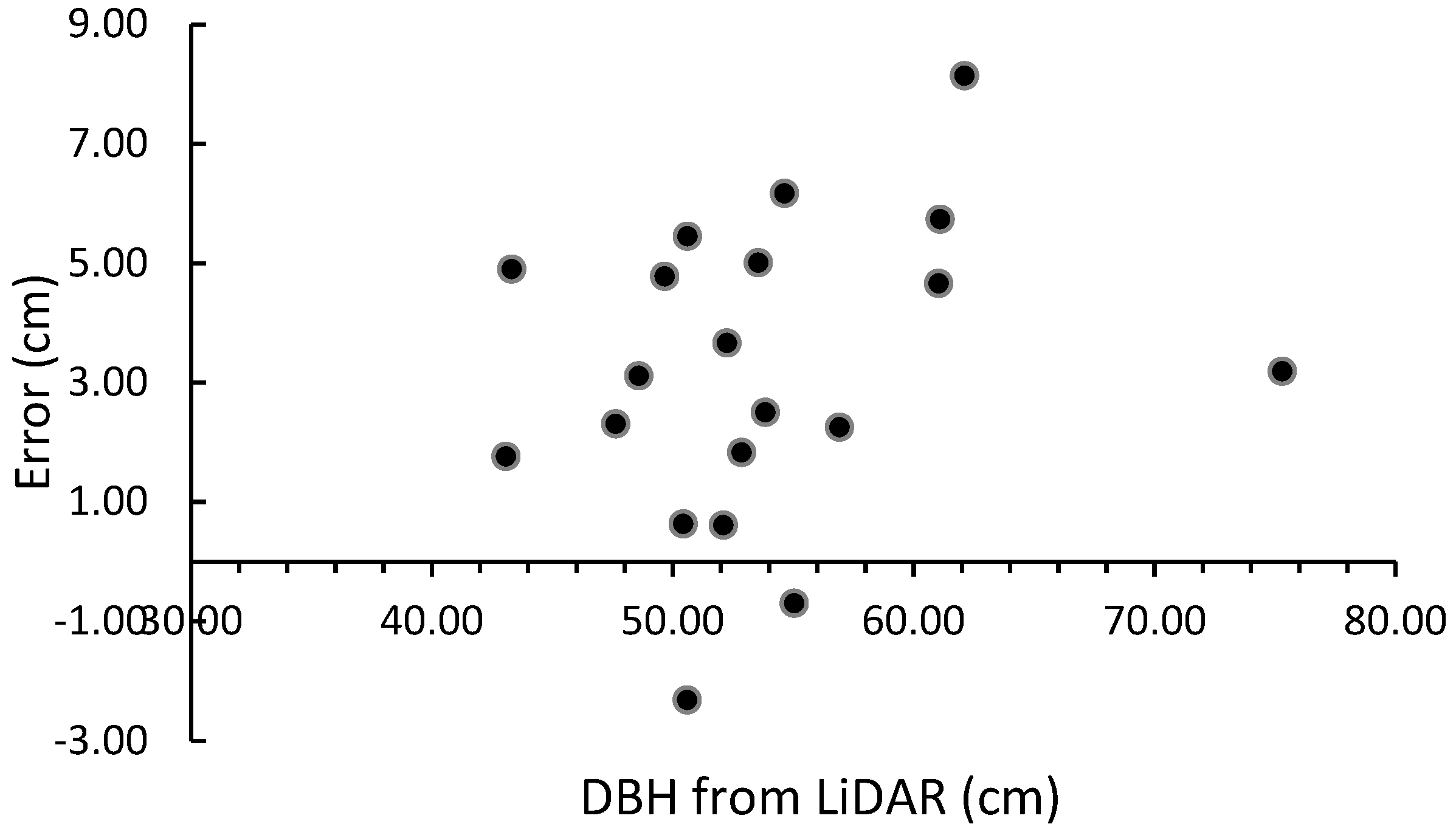
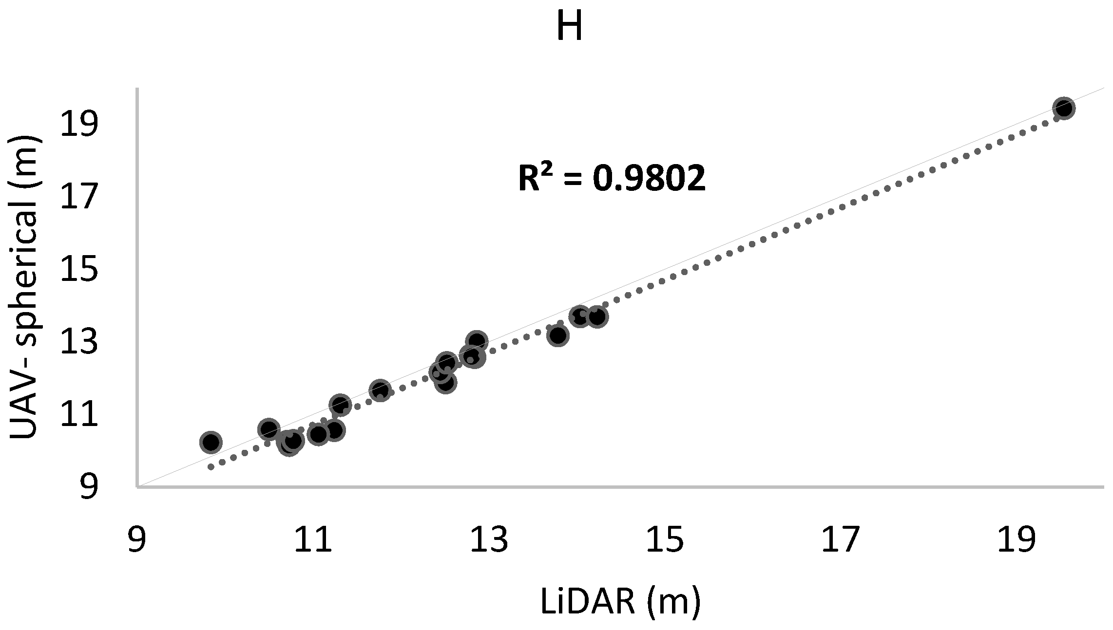
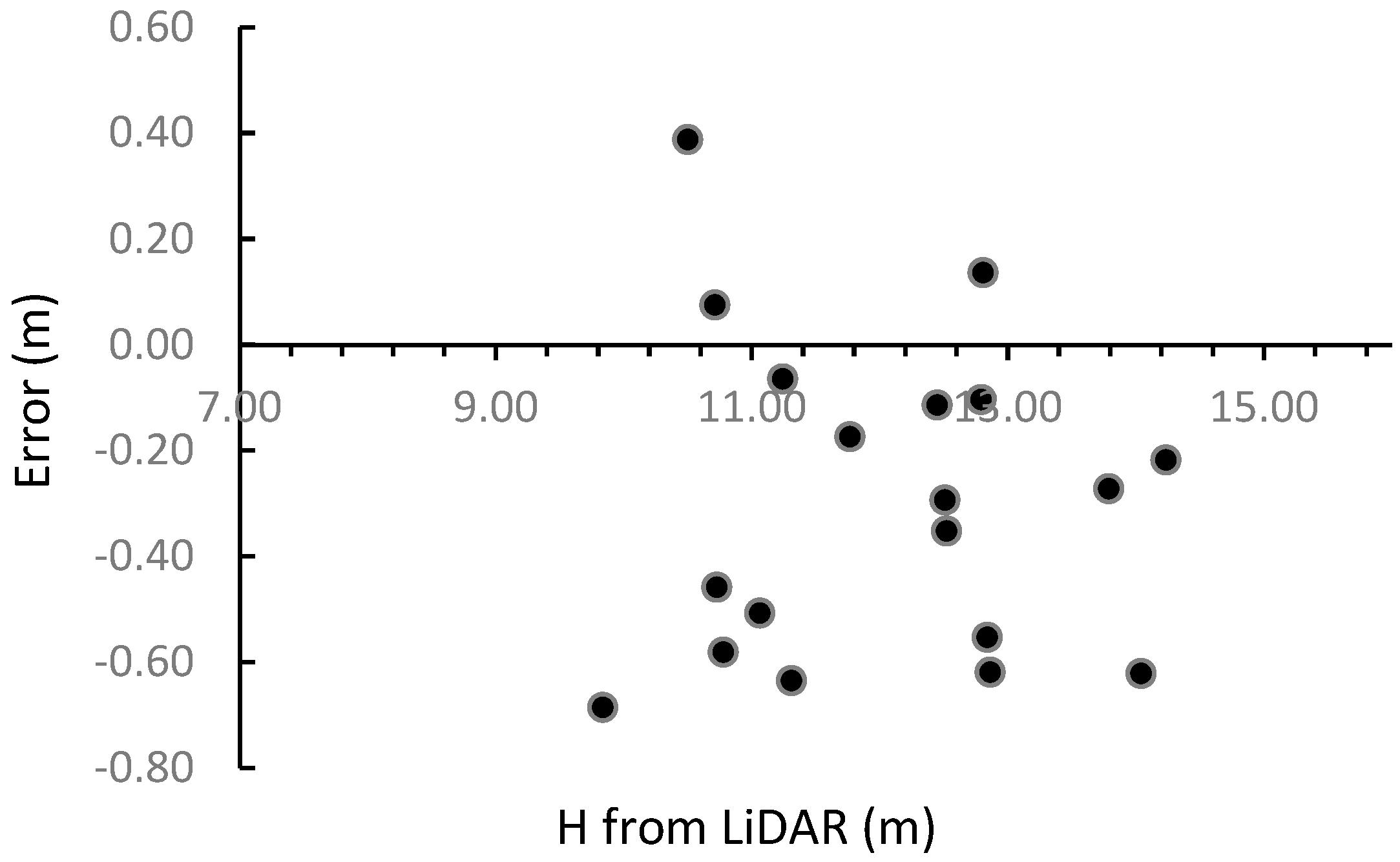
| DBH (cm) | H (m) | |||||||
|---|---|---|---|---|---|---|---|---|
| Tree ID | LiDAR | UAV-Spherical | LiDAR | UAV-Spherical | ||||
| 1 | 61.10 | 66.83 | 11.24 | 10.56 | ||||
| 2 | 62.11 | 70.25 | 9.84 | 10.23 | ||||
| 3 | 53.85 | 56.35 | 10.50 | 10.58 | ||||
| 4 | 54.64 | 60.80 | 10.71 | 10.25 | ||||
| 5 | 50.62 | 56.07 | 10.73 | 10.15 | ||||
| 6 | 43.08 | 44.84 | 10.78 | 10.27 | ||||
| 7 | 47.64 | 49.94 | 11.31 | 11.25 | ||||
| 8 | 61.04 | 65.70 | 12.51 | 11.87 | ||||
| 9 | 56.93 | 59.18 | 12.79 | 12.62 | ||||
| 10 | 50.44 | 51.07 | 11.77 | 11.65 | ||||
| 11 | 52.25 | 55.92 | 12.45 | 12.15 | ||||
| 12 | 53.55 | 58.55 | 14.04 | 13.69 | ||||
| 13 | 48.59 | 51.70 | 12.52 | 12.42 | ||||
| 14 | 50.60 | 48.29 | 12.86 | 13.00 | ||||
| 15 | 75.30 | 78.49 | 14.24 | 13.68 | ||||
| 16 | 52.10 | 52.71 | 13.79 | 13.17 | ||||
| 17 | 49.67 | 54.45 | 12.84 | 12.57 | ||||
| 18 | 43.32 | 48.22 | 11.06 | 10.44 | ||||
| 19 | 52.87 | 54.69 | 12.81 | 12.59 | ||||
| 20 | 55.05 | 54.35 | 19.55 | 19.43 | ||||
| RMSD abs. | RMSD % | RMSD abs. | RMSD % | |||||
| 4.02 | 12.48 | 0.41 | 4.21 | |||||
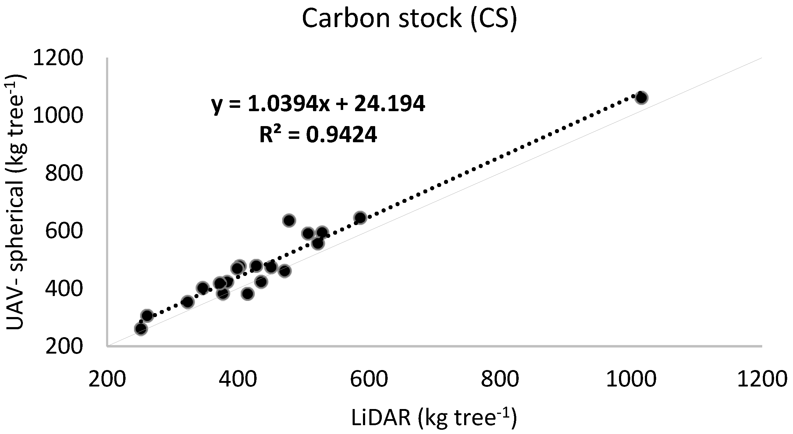
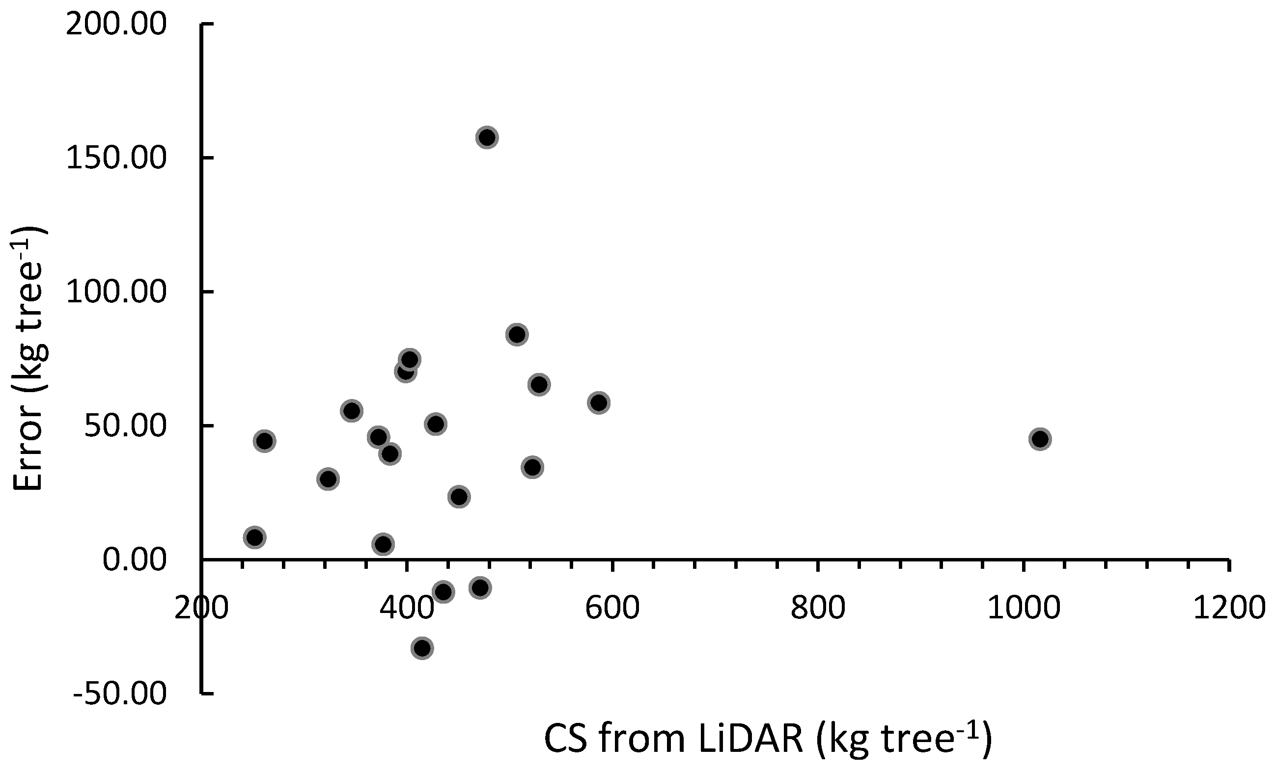
| Tree ID | Tree Species | Total Tree-Stand CS (UAV-Spherical Data) kg tree−1 | Total Tree-Stand CS (LiDAR Data) kg tree−1 | Difference kg tree−1 | ||
|---|---|---|---|---|---|---|
| 1 | Pinus pinea L. | 593.82 | 528.56 | 65.26 | ||
| 2 | Pinus pinea L. | 635.50 | 477.99 | 157.51 | ||
| 3 | Pinus pinea L. | 423.01 | 383.56 | 39.45 | ||
| 4 | Pinus pinea L. | 477.34 | 402.72 | 74.62 | ||
| 5 | Pinus pinea L. | 401.78 | 346.28 | 55.5 | ||
| 6 | Pinus pinea L. | 260.17 | 251.98 | 8.19 | ||
| 7 | Pinus pinea L. | 353.38 | 323.37 | 30.01 | ||
| 8 | Pinus pinea L. | 645.37 | 586.85 | 58.52 | ||
| 9 | Pinus pinea L. | 556.56 | 522.12 | 34.44 | ||
| 10 | Pinus pinea L. | 382.75 | 377.04 | 5.71 | ||
| 11 | Pinus pinea L. | 478.64 | 428.11 | 50.53 | ||
| 12 | Pinus pinea L. | 591.06 | 507.10 | 83.96 | ||
| 13 | Pinus pinea L. | 418.14 | 372.42 | 45.72 | ||
| 14 | Pinus pinea L. | 381.81 | 414.89 | 33.08 | ||
| 15 | Pinus pinea L. | 1061.18 | 1016.23 | 44.95 | ||
| 16 | Pinus pinea L. | 460.86 | 471.41 | 10.55 | ||
| 17 | Pinus pinea L. | 469.23 | 399.03 | 70.2 | ||
| 18 | Pinus pinea L. | 305.80 | 261.55 | 44.25 | ||
| 19 | Pinus pinea L. | 474.29 | 450.81 | 23.48 | ||
| 20 | Platanus hispanica | 423.48 | 435.57 | 12.09 | ||
| RMSD abs. | RMSD% | |||||
| 58.05 | 7.60 |
Disclaimer/Publisher’s Note: The statements, opinions and data contained in all publications are solely those of the individual author(s) and contributor(s) and not of MDPI and/or the editor(s). MDPI and/or the editor(s) disclaim responsibility for any injury to people or property resulting from any ideas, methods, instructions or products referred to in the content. |
© 2024 by the authors. Licensee MDPI, Basel, Switzerland. This article is an open access article distributed under the terms and conditions of the Creative Commons Attribution (CC BY) license (https://creativecommons.org/licenses/by/4.0/).
Share and Cite
Balestra, M.; Choudhury, M.A.M.; Pierdicca, R.; Chiappini, S.; Marcheggiani, E. UAV-Spherical Data Fusion Approach to Estimate Individual Tree Carbon Stock for Urban Green Planning and Management. Remote Sens. 2024, 16, 2110. https://doi.org/10.3390/rs16122110
Balestra M, Choudhury MAM, Pierdicca R, Chiappini S, Marcheggiani E. UAV-Spherical Data Fusion Approach to Estimate Individual Tree Carbon Stock for Urban Green Planning and Management. Remote Sensing. 2024; 16(12):2110. https://doi.org/10.3390/rs16122110
Chicago/Turabian StyleBalestra, Mattia, MD Abdul Mueed Choudhury, Roberto Pierdicca, Stefano Chiappini, and Ernesto Marcheggiani. 2024. "UAV-Spherical Data Fusion Approach to Estimate Individual Tree Carbon Stock for Urban Green Planning and Management" Remote Sensing 16, no. 12: 2110. https://doi.org/10.3390/rs16122110
APA StyleBalestra, M., Choudhury, M. A. M., Pierdicca, R., Chiappini, S., & Marcheggiani, E. (2024). UAV-Spherical Data Fusion Approach to Estimate Individual Tree Carbon Stock for Urban Green Planning and Management. Remote Sensing, 16(12), 2110. https://doi.org/10.3390/rs16122110


