Satellite Advanced Spaceborne Thermal Emission and Reflection Radiometer Mineral Maps of Australia Unmixed of Their Green and Dry Vegetation Components: Implications for Mapping (Paleo) Sediment Erosion–Transport–Deposition Processes
Abstract
1. Introduction
2. Materials and Methods
2.1. ASTER Data Pre-Processing
2.2. Vegetation Cover Issue
2.3. ASTER Vegetation Unmixing Process
- (i)
- A green vegetation index:
- (ii)
- A SWIR-derived dry-vegetation index [21]:
- (iii)
- A TIR-derived dry-vegetation index [22]:
2.4. NGSA Validation Data
- (i)
- AlOH clay absorption depth centered at 2207 nm:
- (ii)
- Kaolinite absorption depth centered at 2165 nm:
- (iii)
- Water absorption depth centered at 1915 nm [64]:
3. Results
3.1. NGSA—ASTER Mineral Indices
- The percentage of clay-sized particles (<2-micron size) “%clay”.
- The geochemical indices:
- Al/(Al + Si), which is an indicator of the proportion of Al-bearing clay minerals to coarser quartz grains;
- Al/(Al + Ca + Mg + Na + K), i.e., based on the chemical index of alteration called the CIA [65];
- Loss-on-ignition (LOI), which is a measure of the volatiles released after heating, including water, organic compounds, and carbonates [66].
- ASD continuum-removed absorption depths, namely:
- AlOH absorption at 2207 nm (Equation (5));
- Kaolin absorption at 2165 nm (Equation (6));
- Water absorption at 1915 nm (Equation (7)).
3.2. NGSA—%Clay
3.3. NGSA—Water Content
3.4. NGSA—AlOH Clay Content
3.5. NGSA—AlOH Clay Composition
3.6. Vegetation Unmixing Process
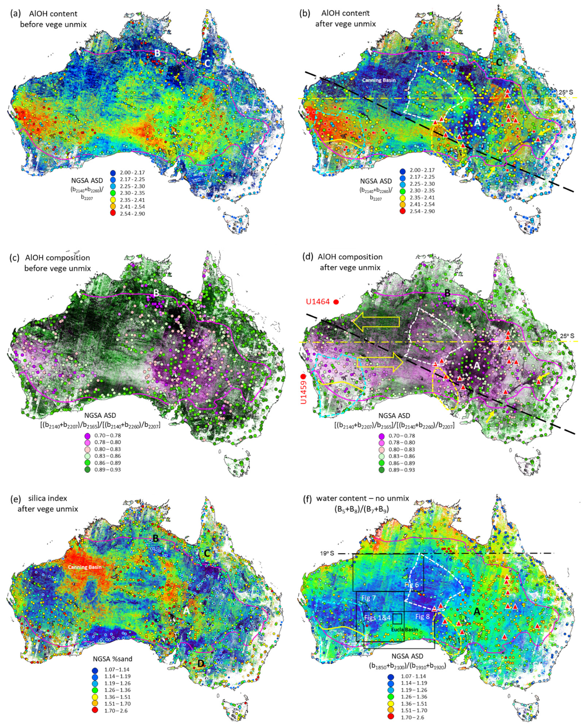
3.7. The Australian Continent ASTER Results
3.8. Paleo-Valleys of the Canning Basin Region
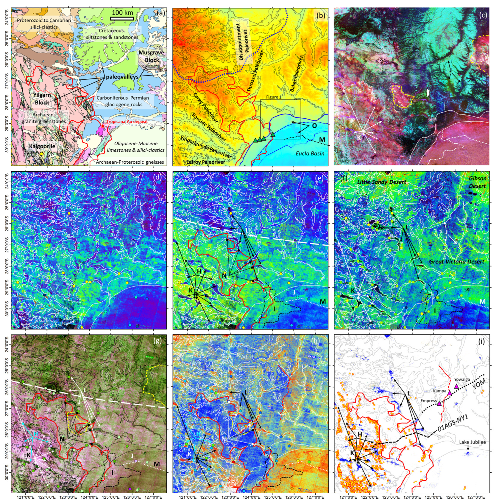
3.9. Paleo-Valleys of the Eastern Yilgarn Craton Region
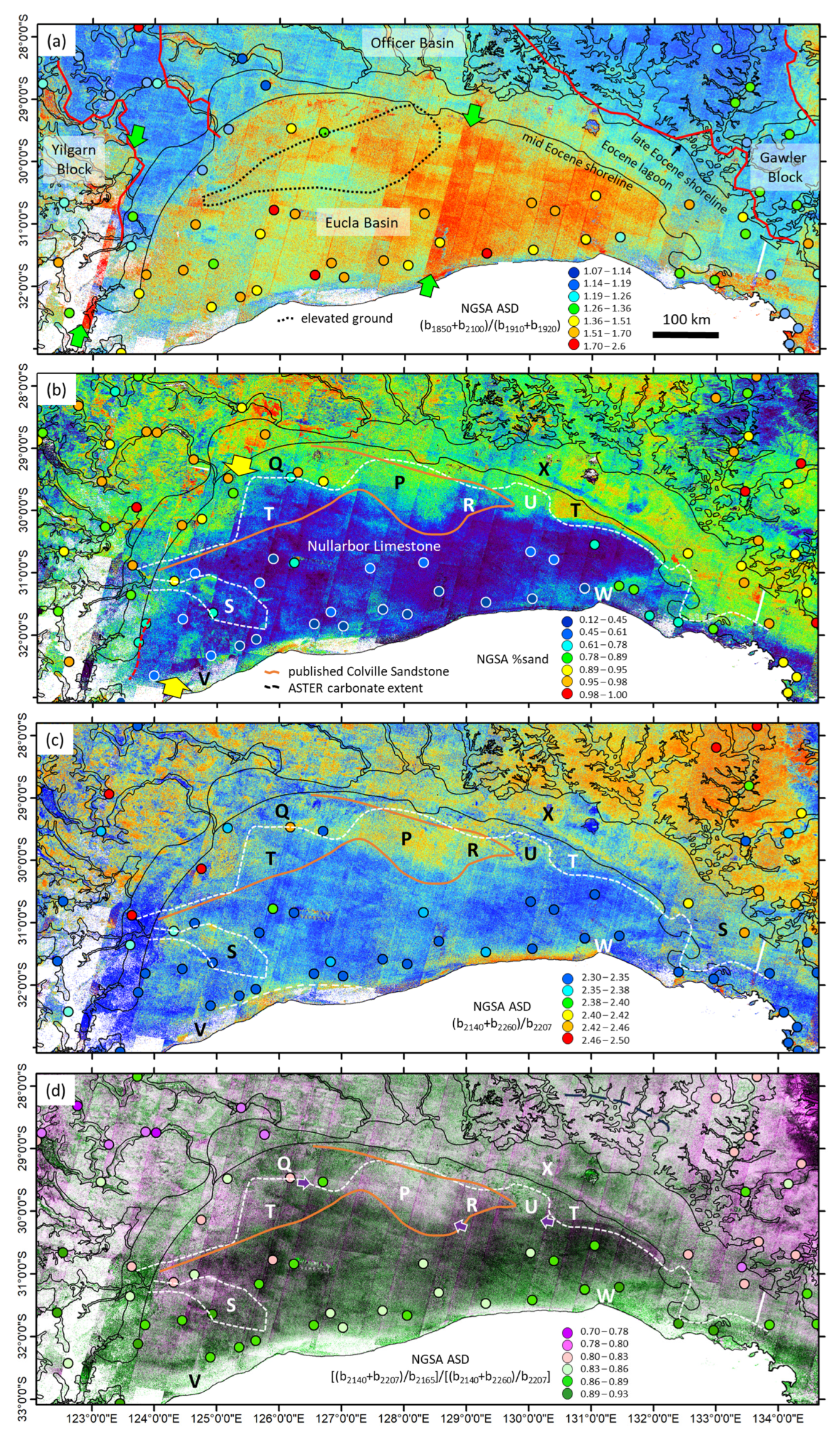
3.10. Miocene Littoral Deposits across the Eucla Basin
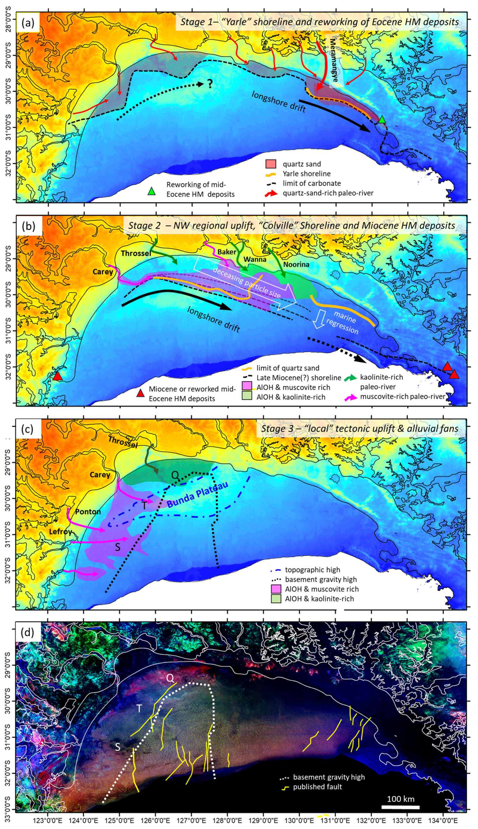
4. Discussion
5. Conclusions
- The AlOH content is more accurately gauged using B7/B6;
- The AlOH composition is more accurately gauged using B7/B5, though in color imagery, we recommend a R:G:B combination of B7/B6: B7/B5: B7/B6;
- The water content is more accurately gauged using (B5 + B8)/(B7 + B9);
- Despite the ASTER’s lack of spectral bands covering diagnostic dry vegetation features, both N-SWIR (Equation (2)) and TIR (Equation (3)) band combinations yield useful approximations, albeit with some residual mineral information remaining and the N-SWIR index showing lesser artefacts (and better pixel resolution);
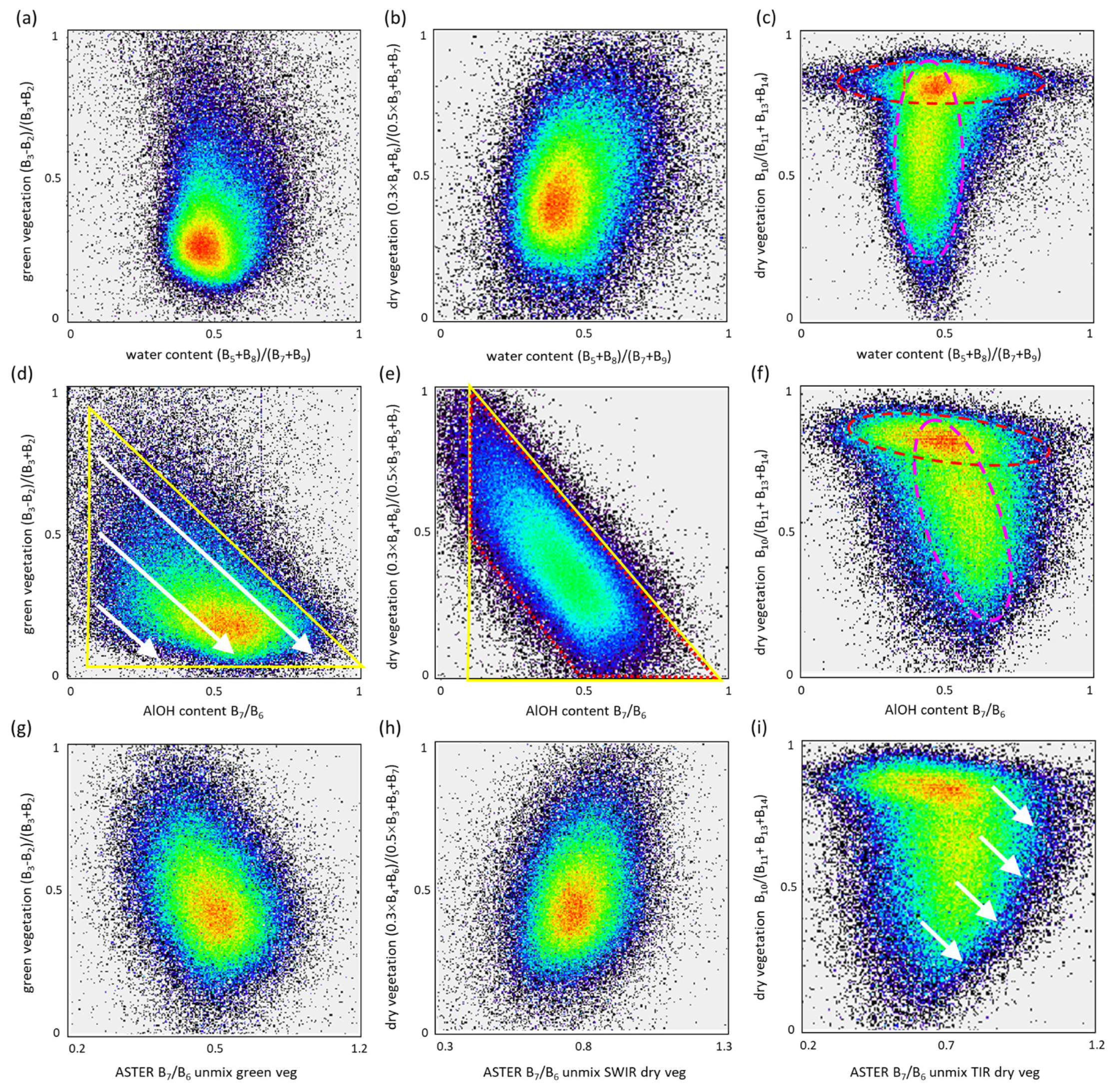
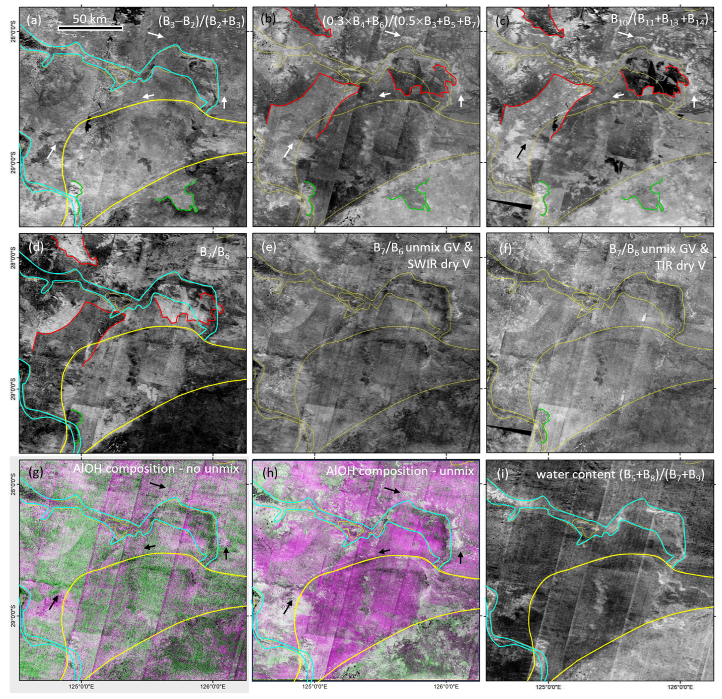
- The ASTER vegetation unmixing strategy requires a stepwise, iterative approach to assess whether vegetation is compromising the pixel mineral information. We recommend using both 2D scattergrams of the target mineral and vegetation indices, a selection of appropriate scale factors (gains in Equation (4)), and a visual assessment of the resultant unmixed imagery. Note that the size of the gains used in the unmixing algorithm can have pronounced, potentially erroneous effects on the derived product if not properly gauged;
- The AlOH content/composition and silica index products were compromised by vegetation, but the water content product was not;
- At a continental-scale, the vegetation unmixing suppresses/removes the vegetation patterns driven by climate-driven rainfall, while at the regional-level, the vegetation unmixing removes the effect of fire scars;
- The new methodology resulted in 90% of the pixels being mapped for mineralogy, in contrast with the 60% provided in the 2012 Australian ASTER mineral products;
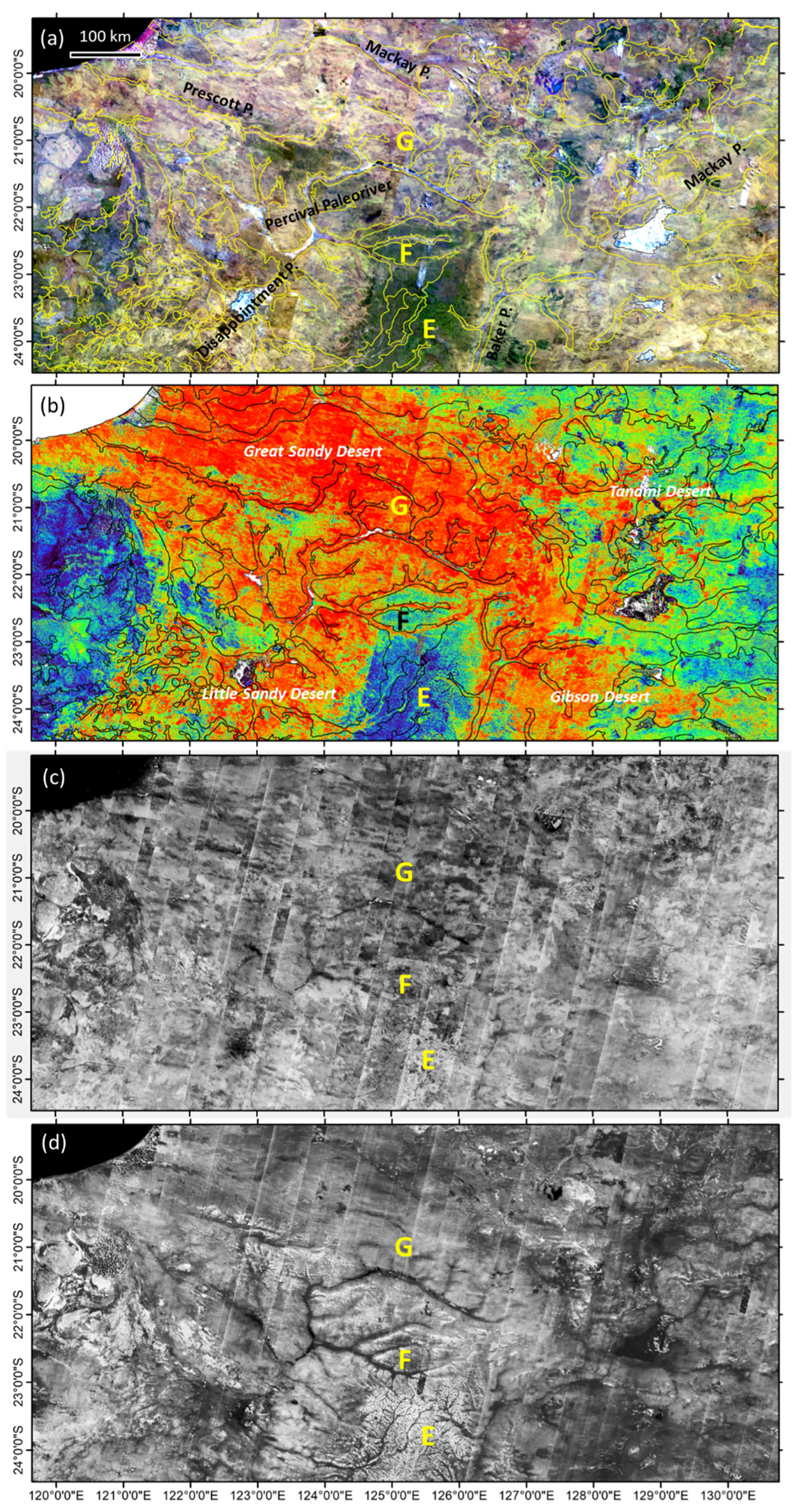
- Vegetation unmixing revealed a regional N–S zonation across the ~25° S latitude, especially in the western half of the continent, characterized by abundant AlOH minerals, especially muscovite, in the south versus less-abundant AlOH minerals, which are relatively kaolinite-rich in the north. This zonation is likely driven by the high-pressure belt and its effect on the prevailing wind patterns and associated transport of aeolian sediment;
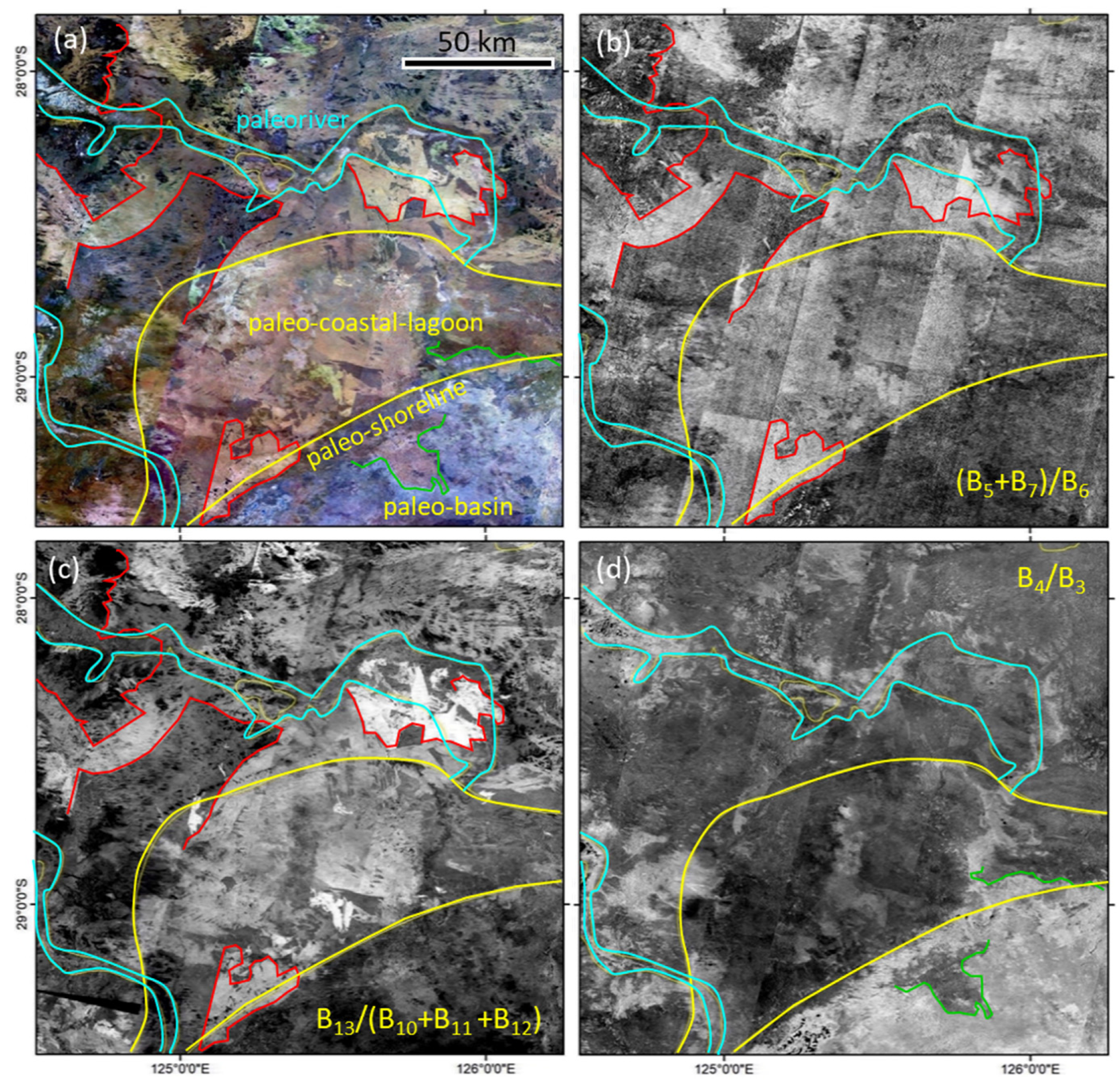
- Vegetation unmixing revealed the paleo-drainage network across the aeolian sand-covered Canning Basin to comprise low AlOH content, similar to the current-day Darling River. In more complex, “upland” geological environments, like the Yilgarn Craton, paleo-rivers have a more complicated, discontinuous surface mineralogical pattern driven by a variety of processes, including catchment rock type and groundwater condition;
- Vegetation unmixing better maps the composition of paleo-rivers (and their source catchments), Miocene shorelines, and alluvial fans across the Eucla Basin, including the Colville Sandstone, which was distinguished by linear patterns in quartz sand and AlOH minerals that present a new opportunity for heavy mineral sand exploration;
- We interpreted the updated ASTER maps of the Eucla Basin to show three stages of basin sedimentation, including: (i) stage 1—high-energy shoreline, Yarle Sandstone development related to tectonic uplift in the NE and relatively higher sea level and removal of the AlOH mineral component; (ii) stage 2—lower-energy shoreline, Colville Sandstone development related to westward shift in tectonic uplift and lowering sea level and the deposition of AlOH minerals from different source regions; and (iii) Stage 3—cessation of the shoreline system caused by a regional westward shift in tectonic uplift coupled with a localized Eucla Basin basement block uplift and lowering sea level resulting in the development of alluvial fans with different AlOH mineral compositions depending on paleo-river catchment rocks;
- The non-vegetation unmixed water content product revealed a 100 km wide, 600 km long “dry” zone located in the eastern margin of the Yilgarn Craton, apparently associated with a deep tectonic structure (from published seismic data and drilling) and an apparent lack of Archaean gold deposits;
- A 1000 km wide circular pattern over the Lake Eyre region, characterized by a broad rim of abundant “muscovite” (and other mineral products), is spatially coincident with opal fields. An explanation for this association is to be followed up in future work.
Author Contributions
Funding
Data Availability Statement
Acknowledgments

Conflicts of Interest
References
- Yamaguchi, Y.; Kahle, A.B.; Tsu, H.; Kawakami, T.; Pniel, M. Overview of Advanced Spaceborne Thermal Emission and Reflection Radiometer (ASTER). IEEE Trans. Geosci. Remote 1998, 36, 1062–1071. [Google Scholar] [CrossRef]
- Clark, R.N. Spectroscopy of rocks and minerals, and principles of spectroscopy. In Manual of Remote Sensing; Rencz, A., Ed.; John Wiley and Sons Inc.: New York, NY, USA, 1999; Chapter 1. [Google Scholar]
- Meyer, J.M.; Kokaly, R.F.; Holley, E. Hyperspectral remote sensing of white mica: A review of imaging and point-based spectrometer studies for mineral resources, with spectrometer design considerations. Remote Sens. Environ. 2022, 275, 113000. [Google Scholar] [CrossRef]
- Rouxhet, P.G.; Samudacheata, N.; Jacobs, H.; Anton, O. Attribution of the OH stretching bands of kaolinite. Clay Miner. 1977, 12, 171–179. [Google Scholar] [CrossRef]
- Cudahy, T. Satellite ASTER Geoscience Product Notes for Australia; EP125895; CSIRO: Canberra, Australia, 2012. [Google Scholar] [CrossRef]
- Cudahy, T.J.; Caccetta, M.; Thomas, M.; Hewson, R.; Abrams, M.; Kato, M.; Kashimura, O.; Ninomiya, Y.; Yamaguchi, Y.; Collings, S.; et al. Satellite-derived mineral mapping and monitoring of weathering, deposition and erosion. Sci. Rep. 2016, 6, 23702. [Google Scholar] [CrossRef] [PubMed]
- Cudahy, T. Mineral Mapping for Exploration: An Australian Journey of Evolving Spectral Sensing Technologies and Industry Collaboration. Geosciences 2016, 6, 52. [Google Scholar] [CrossRef]
- Hewson, R.; Robson, D.; Mauger, A.; Cudahy, T.; Thomas, M.; Jones, M. Using the Geoscience Australia-CSIRO ASTER maps and airborne geophysics to explore Australian geoscience. J. Spat. Sci. 2015, 60, 207–231. [Google Scholar] [CrossRef]
- Hewson, R.; Robson, D.; Carlton, A.; Gilmore, P. Geological application of ASTER remote sensing within sparsely outcropping terrain, Central New South Wales, Australia. Cogent Geosci. 2017, 3, 1319259. [Google Scholar] [CrossRef]
- Lampinen, H.M.; Laukamp, C.; Occhipinti, S.A.; Metelka, V.; Spinks, S.C. Delineating alteration footprints from field and ASTER SWIR spectra, geochemistry, and gamma-ray spectrometry above regolith-covered base metal deposits—An example from Abra, Western Australia. Econ. Geol. 2017, 112, 1977–2003. [Google Scholar] [CrossRef]
- Lau, I.C.; Cudahy, T.J.; Caccetta, M.C.; Kobayashi, C.; Kashimura, O.; Kato, M. Proximal, remote sensing and spectroscopy of soil Mapping surface soil mineralogy using hyperspectral and ASTER imagery: An example from Mullewa, Western Australia. In Digital Soil Assessments and Beyond; CRC Press: Boca Raton, FL, USA, 2012; ISBN 9780429097461. [Google Scholar]
- Laukamp, C.; Cudahy, T.; Caccetta, M.; Thomas, M.; Close, D.; Lennartz, R. Successful mineral exploration using multispectral remote sensing data—ASTER geoscience Map of Australia. In Proceedings of the 12th SGA Biennial Meeting, Uppsala, Sweden, 12–15 August 2013. 4p. [Google Scholar]
- Laukamp, C.; Salama, W.; González-Álvarez, I. Proximal and remote spectroscopic characterisation of regolith in the Albany–Fraser Orogen (Western Australia). Ore Geol. Rev. 2016, 73, 540–554, ISSN 0169-1368. [Google Scholar] [CrossRef]
- Mernagh, T.P.; Bastrakov, E.N.; Clarke, J.D.A.; de Caritat, P.; English, P.M.; Howard, F.J.F.; Jaireth, S.; Magee, J.W.; McPherson, A.A.; Roach, I.C.; et al. A Review of Australian Salt Lakes and Assessment of Their Potential for Strategic Resources; Record 2013/039; Geoscience Australia: Canberra, Australia, 2013. Available online: https://pid.geoscience.gov.au/dataset/ga/76454 (accessed on 10 May 2023).
- Rutherford, J.; Cendón, D.I.; Soerensen, C.; Batty, S.; Huntley, B.; Bourke, L.; Pinder, A.; Quinlan, K.; English, V.; Coote, M. Hydrological Conceptualisation of the Walyarta Mound Springs; Department of Biodiversity, Conservation and Attractions, Wetlands Conservation Program: Perth, Australia, 2018. Available online: https://library.dbca.wa.gov.au/static/FullTextFiles/072271.pdf (accessed on 15 February 2023).
- Rouse, J.W.; Haas, R.H.; Scheel, J.A.; Deering, D.W. Monitoring Vegetation Systems in the Great Plains with ERTS. In Proceedings of the 3rd Earth Resource Technology Satellite (ERTS) Symposium, Washington, DC, USA, 10–14 December 1974; Volume 1, pp. 48–62. Available online: https://ntrs.nasa.gov/citations/19740022614 (accessed on 4 April 2024).
- Elvidge, C.D. Thermal Infrared Reflectance of Dry Plant Materials: 2.5–20.0um. Remote Sens. Environ. 1998, 26, 265–285. [Google Scholar] [CrossRef]
- Serbin, G.; Hunt, E.R., Jr.; Daughtry, C.S.T.; McCarty, G.W.; Doraiswamy, P.C. An improved ASTER index for remote sensing of crop residue. Remote Sens. 2009, 1, 971–991. [Google Scholar] [CrossRef]
- Gill, T.K.; Phinn, S. Estimates of bare ground and vegetation cover from Advanced Spaceborne Thermal Emission and Reflection Radiometer (ASTER) short-wave-infrared reflectance imagery. J. Appl. Remote Sens. 2008, 2, 023511. [Google Scholar] [CrossRef]
- Lehmann, E.A.; Wallace, J.F.; Caccetta, P.; Zdunic, K. Forest cover trends from time series Landsat data for the Australian continent. Int. J. Appl. Earth Obs. Geoinf. 2013, 21, 453–462. [Google Scholar] [CrossRef]
- Cudahy, T.J.; Jones, M.; Lisitsin, V.A.; Caccetta, M.; Collings, S.; Bateman, R. 3D Mineral Mapping of Queensland—Version 2 ASTER and Related Geoscience Products; EP17697; CSIRO: Kensington, Australia, 2017. [Google Scholar] [CrossRef]
- Caccetta, M.; Cudahy, T.; Ong, C.; Lau, I. An investigation into the use of the thermal wavelengths of the ASTER satellite borne sensor for dry vegetation identification. In Proceedings of the IGARSS 2016—2016 IEEE International Geoscience and Remote Sensing Symposium, Beijing, China, 10–15 July 2016; pp. 1943–1946. [Google Scholar] [CrossRef]
- Salisbury, J.W. Preliminary measurements of leaf spectral reflectance in the 8–14 μm region. Int. J. Remote Sens. 1986, 7, 1879–1886. [Google Scholar] [CrossRef]
- Craig, M.A. Unsupervised unmixing of remotely sensed images. In Proceedings of the 5th Australasian Remote Sensing Conference, Perth, Australia, 8–12 October 1990; pp. 324–330. [Google Scholar]
- Bierwirth, P.N. Mineral mapping and vegetation removal via data-calibrated pixel unmixing, using multispectral images. Int. J. Remote Sens. 1990, 11, 1999–2017. [Google Scholar] [CrossRef]
- Boardman, J. Automating Spectral Unmixing of AVIRIS Data Using Convex Geometry Concepts. In Proceedings of the Summaries of the 4th Annual JPL Airborne Geoscience Workshop, Washington, DC, USA, 25–29 October 1993; pp. 11–14. [Google Scholar]
- Craig, M.D. Minimum volume transformations for remotely sensed data. IEEE Trans. Geosci. Remote Sens. 1994, 32, 542–552. [Google Scholar] [CrossRef]
- Staenz, K.; Nadeau, C.; Secker, J.; Budkewitsch, P. Spectral unmixing applied to vegetated environments in the Canadian Artic for mineral mapping. Int. Arch. Photogramm. Remote Sens. 2000, 33, 1464–1471. [Google Scholar]
- Asner, G.P.; Heidebrecht, K.B. Spectral unmixing of vegetation, soil and dry carbon in arid regions: Comparing multispectral and hyperspectral observations. Int. J. Remote Sens. 2002, 23, 3939–3958. [Google Scholar] [CrossRef]
- Rodger, R.; Cudahy, T. Vegetation corrected continuum depths at 2.20 µm: An approach for hyperspectral sensors. Remote Sens. Environ. 2009, 113, 2243–2257. [Google Scholar] [CrossRef]
- Grebby, S.; Cunningham, D.; Tansey, K.; Naden, J. The Impact of Vegetation on Lithological Mapping Using Airborne Multispectral Data: A Case Study for the North Troodos Region, Cyprus. Remote Sens. 2014, 6, 10860–10887. [Google Scholar] [CrossRef]
- Haest, M.; Cudahy, T.; Rodger, A.; Laukamp, C.; Martens, E.; Caccetta, M. Unmixing the effects of vegetation in airborne hyperspectral mineral maps over the Rocklea Dome iron-rich palaeochannel system (Western Australia). Remote Sens. Environ. 2013, 129, 17–31. [Google Scholar] [CrossRef]
- De Souza Kovacs, N.; Cudahy, T.J. Regolith–Landform Mapping of the West Kimberley Craton: Application of Geophysics and Spectral Remote Sensing; Report 231; Geological Survey of Western Australia: Perth, Australia, 2022; 87p.
- Australian ASTER Reflectance/Emissivity Mosaic. Geoscience Australia, Canberra. Available online: https://dev.ecat.ga.gov.au/geonetwork/srv/api/records/1a311ac9-66a8-4557-957d-e1c035610711 (accessed on 31 May 2023).
- Caccetta, M.; Collings, S.; Cudahy, T. A calibration methodology for continental-scale mapping using ASTER imagery. Remote Sens. Environ. 2013, 139, 306–317. [Google Scholar] [CrossRef]
- De Caritat, P.; Cooper, M. National Geochemical Survey of Australia: The Geochemical Atlas of Australia; Record 2011/20; Geoscience Australia: Canberra, Australia, 2011; 557p. [Google Scholar]
- De Caritat, P. The National Geochemical Survey of Australia: Review and impact. Geochem. Explor. Environ. Anal. 2022, 22, geochem2022-032. [Google Scholar] [CrossRef]
- Lau, I.C.; Laukamp, C.; Bateman, R.; Beattite, E.; de Caritat, P.; Ong, C.; Thomas, M.; Caccetta, M.; Wang, R.; Cudahy, T. Spectral Reflectance Measurement Procedures for Soil and Powder Samples; Report number: E18382; The Commonwealth Scientific and Industrial Research Organisation (CSIRO): Canberra, Australia, 2018; 39p. [Google Scholar]
- Boreham, C.J.; Edwards, D.S.; Czado, K.; Rollet, N.; Wang, L.; van der Weilen, S.; Champion, D.; Blewett, R.; Feitz, A.; Henson, P.A. Hydrogen in Australian natural gas: Occurrences, sources and resources. APPEA J. 2021, 61, 163–191. [Google Scholar] [CrossRef]
- Wyrwoll, K.-H. Time in the geomorphology of Western Australia. Prog. Phys. Geogr. Earth Environ. 1988, 12, 237–263. [Google Scholar] [CrossRef]
- Tapley, I.J. The reconstruction of palaeodrainage and regional geologic structures in Australia’s Canning and Officer Basins using NOAA–AVHRR satellite imagery. Earth Sci. Rev. 1988, 25, 409–425. [Google Scholar] [CrossRef]
- Kern, A.M.; Commander, D.P. Cainozoic stratigraphy in the Roe Palaeodrainage of the Kalgoorlie region, Western Australia. Geol. Surv. West. Aust. Prof. Pap. 1993, 34, 85–95. Available online: https://geodocs.dmirs.wa.gov.au/Web/documentlist/3/Combined/N91CP%2FH (accessed on 1 July 2023).
- Morgan, K.H. Development, sedimentation and economic potential of palaeoriver systems of the Yilgarn Craton of Western Australia. Sediment. Geol. 1993, 85, 637–656, ISSN 0037-0738. [Google Scholar] [CrossRef]
- Hou, B.; Keeling, J.; Li, Z. Paleovalley-related uranium deposits in Australia and China: A review of geological and exploration models and methods. Ore Geol. Rev. 2017, 88, 201–234, ISSN 0169-1368. [Google Scholar] [CrossRef]
- De Broekert, P.; Sandiford, M. Buried Inset-Valleys in the Eastern Yilgarn Craton, Western Australia: Geomorphology, Age, and Allogenic Control. J. Geol. 2005, 113, 471–493. [Google Scholar] [CrossRef]
- George, R.; Clarke, J.; English, P. Modern and palaeogeographic trends in the salinisation of the Western Australian Wheatbelt. ASEG Ext. Abstr. 2006, 1, 1–22. [Google Scholar] [CrossRef]
- Bell, J.G.; Kilgour, P.L.; English, P.M.; Woodgate, M.F.; Lewis, S.J. WASANT Palaeovalley Map—Distribution of Palaeovalleys in Arid and Semi-Arid WA-SA-NT; Geoscience Australia: Canberra, Australia, 2012. Available online: https://ecat.ga.gov.au/geonetwork/srv/eng/catalog.search#/metadata/73980 (accessed on 14 February 2023).
- Pain, C.F.; Pillans, B.J.; Roach, I.A.; Worrall, L.; Wilford, J.R. Old, flat and red—Australia’s distinctive landscape. In Shaping a Nation: A Geology of Australia; Blewett, R.S., Ed.; ANU Press: Canberra, Australian, 2012; Chapter 5; pp. 227–276. [Google Scholar]
- Brocard, G.; Ding, X.; Salles, T.; Zahirovic, S.; Rey, P.; Möller, D. Transcontinental Cainozoic paleovalleys of Western Australia. ASEG Ext. Abstr. 2018, 1, 1–6. [Google Scholar] [CrossRef]
- Hou, B.; Keeling, J.; Reid, A.; Petts, A.; Stoian, L. Eucla Basin and Peripheral Paleovalleys; Report Book 2022/00011; Department for Energy and Mining, South Australia: Adelaide, Australia, 2022; 131p. [Google Scholar]
- Hutchinson, M.F.; Stein, J.L.; Stein, J.A.; Anderson, H.; Tickle, P.K. GEODATA 9 Second DEM and D8: Digital Elevation Model Version 3 and Flow Direction Grid 2008; Record DEM-9S.v3; Geoscience Australia: Canberra, Australia, 2008. Available online: http://pid.geoscience.gov.au/dataset/ga/66006 (accessed on 10 May 2023).
- Jakica, S.; Brisbout, L.; de Souza Kovacs, N. Applying Geophysics for 3D Paleochannel Imaging in the Gascoyne Province, Western Australia; Record 2021/7; Geological Survey of Western Australia: Perth, Australia, 2021; 27p.
- Radiometric Grid of Australia (Radmap) v4 2019—Ternary Image (K, Th, U). Geoscience Australia. Available online: https://ecat.ga.gov.au/geonetwork/srv/eng/catalog.search#/metadata/134857 (accessed on 13 March 2019).
- Hou, B.; Keeling, J.; van Gosen, B.S. Geological and exploration models of beach placer deposits, integrated from case-studies of Southern Australia. Ore Geol. Rev. 2017, 80, 437–459. [Google Scholar] [CrossRef]
- Ninomiya, Y. Quantitative estimation of SiO2 content in igneous rocks using thermal infrared spectra with a neural network approach. IEEE Trans. Geosci. Remote Sens. 1995, 33, 684–691. [Google Scholar] [CrossRef]
- Hook, S.J.; Dmochowski, J.E.; Howard, K.A.; Rowan, L.C.; Karlstrom, K.E.; Stock, J.M. Mapping variations in weight percent silica measured from multispectral thermal infrared imagery—Examples from the Hiller Mountains, Nevada, USA and Tres Virgenes-La Reforma, Baja California Sur, Mexico. Remote Sens. Environ. 2005, 95, 273–289, ISSN 0034-4257. [Google Scholar] [CrossRef]
- Post, J.L.; Noble, P.N. The Near-Infrared Combination Band Frequencies of Dioctahedral Smectites, Micas, and Illites. Clays Clay Miner. 1993, 41, 639–644. [Google Scholar] [CrossRef]
- Crowley, J.K.; Brickey, D.W.; Rowan, L.C. Airborne imaging spectrometer data of the Ruby Mountains, Montana: Mineral discrimination using relative absorption band-depth images. Remote Sens. Environ. 1989, 29, 121–134. [Google Scholar] [CrossRef]
- Green, A.A.; Craig, M.D. Analysis of aircraft spectrometer data with logarithmic residuals. In Proceedings of the Airborne Imaging Spectrometer Workshop, Pasadena, CA, USA, 8–10 April 1985; Vane, G., Goetz, A.F.H., Eds.; JPL Publication 85-41; JPL: Pasadena, CA, USA, 1985; pp. 111–119. [Google Scholar]
- Feng, J.; Rivard, B.; Sánchez-Azofeifa, A. The topographic normalization of hyperspectral data: Implications for the selection of spectral end members and lithologic mapping. Remote Sens. Environ. 2003, 85, 221–231, ISSN 0034-4257. [Google Scholar] [CrossRef]
- Iwasaki, A.; Tonooka, H. Validation of a crosstalk correction algorithm for ASTER/SWIR. IEEE Trans. Geosci. Remote Sens. 2005, 43, 2747–2751. [Google Scholar] [CrossRef]
- Murphy, R.J.; Wadge, G. The effects of vegetation on the ability to map soils using imaging spectrometer data. Int. J. Remote Sens. 1994, 15, 63–86. [Google Scholar] [CrossRef]
- Luz, B.; Crowley, J. Spectral reflectance and emissivity features of broad leaf plants: Prospects for remote sensing in the thermal infrared (8.0–14.0 μm). Remote Sens. Environ. 2007, 109, 393–405. [Google Scholar] [CrossRef]
- Milliken, R.E.; Mustard, J.F. Quantifying absolute water content of minerals using near-infrared reflectance spectroscopy. J. Geophys. Res. 2005, 110, E12001. [Google Scholar] [CrossRef]
- Nesbitt, H.W.; Young, G.M. Early Proterozoic climates and plate motions inferred from major element chemistry of lutites. Nature 1982, 299, 715–717. [Google Scholar] [CrossRef]
- Lechler, P.J.; Desilets, M.O. A review of the use of loss on ignition as a measurement of total volatiles in whole-rock analysis. Chem. Geol. 1987, 63, 341–344, ISSN 0009-2541. [Google Scholar] [CrossRef]
- Cooper, D.C.; Mustard, J.F. Effects of very Fine Particle Size on reflectance spectra of smectite and palagonitic soil. Icarus 1999, 142, 557–570. [Google Scholar] [CrossRef]
- Low, P.F.; White, J.L. Hydrogen bonding and polywater in clay-water systems. Clays Clay Miner. 1970, 18, 63–66. [Google Scholar] [CrossRef]
- Moenke, H.H.W. Vibrational Spectra and the Crystal-chemical Classification of Minerals. In The Infrared Spectra of Minerals; Farmer, V.C., Ed.; Mineralogical Society of Great Britain and Ireland: Londan, UK, 1974; pp. 111–118. [Google Scholar] [CrossRef]
- Gray, D.J. Spectral Reflectance Studies of the Impact of Water on Mineral Spectra; CSIRO/AMIRA Project P435, Report 444R; Australian Mineral Industries Research Association, Ltd.: Parkville, Australia, 1997; 82p. [Google Scholar]
- Chen, X.Y.; McKenzie, N.J.; Roach, I.C. Distribution in Australia: Calcrete landscapes. In Calcrete: Characteristics, Distribution and Use in Mineral Exploration; Chen, X.Y., Lintern, M.J., Roach, I.C., Eds.; Cooperative Research Centre for Landscape Environments and Mineral Exploration: Bentley, Australia, 2002; pp. 110–138. ISBN 0-9581145-0-1. Available online: http://crcleme.org.au/Pubs/Monographs/Calcrete%20Book%20-%20FINAL.pdf (accessed on 22 February 2023).
- Fraser, S.J.; Green, A.A. A software defoliant for geological analysis of band ratios. Int. J. Remote Sens. 1987, 8, 525–532. [Google Scholar] [CrossRef]
- Sánchez, F.G.; Luc, R.; Van Loon, L.R.; Gimmi, T.; Jakob, A.; Glaus, M.A.; Diamond, L.W. Self-diffusion of water and its dependence on temperature and ionic strength in highly compacted montmorillonite, illite and kaolinite. Appl. Geochem. 2008, 23, 3840–3851. [Google Scholar] [CrossRef]
- Duda, K.; Daucsavage, J. Advanced Spaceborne Thermal Emission and Reflection Radiometer (ASTER) Level 1 Precision Terrain Corrected Registered At-Sensor Radiance Product (AST_L1T)—AST_L1T Product User’s Guide; Version 1.1; USGS EROS Data Center, Sioux Falls South Dakota: Sioux Falls, SD, USA, 2020. Available online: https://lpdaac.usgs.gov/documents/647/AST__L1T_User_Guide_V3.pdf (accessed on 11 February 2024).
- Anand, R.R.; Paine, M. Regolith geology of the Yilgarn Craton, Western Australia: Implications for exploration. Aust. J. Earth Sci. 2002, 49, 3–162. [Google Scholar] [CrossRef]
- Groeneveld, J.; Henderiks, J.; Renema, W.; McHugh, C.M.; De Vleeschouwer, D.; Christensen, B.A.; Fulthorpe, C.S.; Reuning, L.; Gallagher, S.J.; Bogus, K.; et al. Australian shelf sediments reveal shifts in Miocene Southern Hemisphere westerlies. Sci. Adv. 2017, 3, e1602567. [Google Scholar] [CrossRef]
- Kennett, B. AusMoho, Australian Passive Seismic Server (AusPass) and the Australian National University Data Commons; ANU Press: Canberra, Australia, 2019. [Google Scholar] [CrossRef]
- Sandiford, M. The tilting continent: A new constraint on the dynamic topographic field from Australia. Earth Planet. Sci. Lett. 2007, 261, 152–163, ISSN 0012-821X. [Google Scholar] [CrossRef]
- Butt, C.R.M.; Horwitz, R.C.H.; Mann, A.W. Uranium Occurrences in Calcrete and Associated Sediments in Western Australia; Report FP16; CSIRO Division of Mineralogy: Perth, Australia, 1977. [Google Scholar]
- Gray, D.J. Hydrogeochemistry in the Yilgarn Craton. Geochem. Explor. Environ. Anal. 2001, 1, 253–264. [Google Scholar] [CrossRef]
- Hocking, R.M. In Geology and Mineral Resources of Western Australia; Memoir 3; Geological Survey of Western Australia: Perth, Australia, 1990; pp. 548–561. [Google Scholar]
- Hocking, R.M.; Mory, A.J.; Williams, I.R. An Atlas of Neoproterozoic and Phanerozoic Basins of Western Australia; Petroleum Exploration Society of Australia (PESA): Beaumaris, Australia, 1994; 34p, Available online: https://pesa.com.au/the_sedimentary_basins_of_wa_p21-43-pdf (accessed on 30 May 2023).
- English, P.; Lewis, S.; Bell, J.; Wischusen, J.; Woodgate, M.; Bastrakov, E.; Macphail, M.; Kilgour, P. Water for Australia’s Arid Zone—Identifying and Assessing Australia’s Palaeovalley Groundwater Resources: Summary Report; Waterlines report; National Water Commission: Canberra, Australia, 2012; 129p, ISBN 978-1-922136-01-5. [Google Scholar]
- Buckingham, W.F.; Sommer, S.E. Mineralogical characterization of rock surfaces formed by hydrothermal alteration and weathering—Application to remote sensing. Econ. Geol. 1983, 78, 664–674. [Google Scholar] [CrossRef]
- Clark, R.N. Spectral properties of mixtures of montmorillonite and dark carbon grains: Implications for remote sensing minerals containing chemically and physically absorbed water. J. Geophys. Res. 1983, 88, 10635–10644. [Google Scholar] [CrossRef]
- Geoview, W.A. The Geological Survey of Western Australia’s Interactive Geological Map. Available online: https://www.dmp.wa.gov.au/GeoView-WA-Interactive-1467.aspx (accessed on 16 February 2023).
- Haines, P.W.; Hocking, R.M.; Grey, K.; Stevens, M.K. Vines 1 revisited: Are older Neoproterozoic glacial deposits preserved in Western Australia? Aust. J. Earth Sci. 2008, 55, 397–406. [Google Scholar] [CrossRef]
- Beard, J.S. Palaeogeography and drainage evolution in the Gibson and Great Victoria Deserts, Western Australia. J. R. Soc. West. Aust. 2002, 85, 17–29. Available online: https://www.biodiversitylibrary.org/partpdf/298673 (accessed on 10 September 2023).
- Hou, B.; Frakes, L.; Sandiford, M.; Worrall, L.; Keeling, J.; Alley, N.F. Cenozoic Eucla Basin and associated palaeovalleys, southern Australia—climatic and tectonic influences on landscape volution, sedimentation and heavy mineral accumulation. Sediment. Geol. 2008, 203, 112–130. [Google Scholar] [CrossRef]
- Ward, S.H. Gamma-ray spectrometry in geological mapping and uranium exploration. Econ. Geol. 1981, 75, 840–849. [Google Scholar]
- Potter, R.M.; Rossman, G.R. Desert Varnish: The Importance of Clay Minerals. Science 1977, 196, 1446–1448. [Google Scholar] [CrossRef]
- Gray, D.J.; Bardwell, N. Hydrogeochemistry of Western Australia: Data Release: Accompanying Notes; EP156404; CSIRO: Canberra, Australia, 2016; 33p. [Google Scholar] [CrossRef]
- Gray, D.J.; Reid, N.; Noble, R.; Thorne, R.; Giblin, A. Hydrogeochemical Mapping of the Australian Continent; EP195905; CSIRO: Canberra, Australia, 2019; 110p. [Google Scholar] [CrossRef]
- Groves, D.I.; Phillips, G.N.; Ho, S.E.; Houston, S.M.; Standing, C.A. Craton-scale distribution of Archean greenstone gold deposits; predictive capacity of the metamorphic model. Econ. Geol. 1987, 82, 2045–2058. [Google Scholar] [CrossRef]
- Korsch, R.J.; Blewett, R.S.; Smithies, R.H.; Quentin de Gromard, R.; Howard, H.M.; Pawley, M.J.; Carr, L.K.; Hocking, R.M.; Neumann, N.L.; Kennett, B.L.N.; et al. Geological setting and interpretation of the southwest half of deep seismic reflection line 11GA-YO1: Yamarna Terrane of the Yilgarn Craton and the western Officer Basin. In Yilgarn Craton–Officer Basin–Musgrave Province Seismic and MT Workshop Edition; Record, 2013/28; Neumann, N.L., Ed.; Geoscience Australia: Canberra, Australia, 2013; Chapter 3. [Google Scholar]
- Grey, K.; Hocking, R.M.; Stevens, M.K.; Bagas, L.; Carlsen, G.M.; Irimies, F.; Pirajno, F.; Haines, P.W.; Apak, S.N. Lithostratigraphic Nomenclature of the Officer Basin and Correlative Parts of the Paterson Orogen, Western Australia; Report 93; Western Australia Geological Survey: Perth, Australia, 2005; 89p. [Google Scholar]
- Gartmair, G.; Barham, M.; Kirkland, C.L. Detrital Zircon Perspectives on Heavy Mineral Sand Systems, Eucla Basin, Australia. Econ. Geol. 2022, 117, 383–399. [Google Scholar] [CrossRef]
- Auscope National Virtual Core Library (NVCL). Available online: https://www.auscope.org.au/nvcl (accessed on 13 February 2024).
- Goleby, B.R.; Blewett, R.S.; Korsch, R.J.; Champion, D.C.; Cassidy, K.F.; Jones, L.E.A.; Groenewald, P.B.; Henson, P. Deep seismic reflection profiling in the Archaean northeastern Yilgarn Craton, Western Australia: Implications for crustal architecture and mineral potential. Tectonophysics 2009, 388, 119–133. [Google Scholar] [CrossRef]
- Lowry, D.C. Geology of the Western Australian Part of the Eucla Basin; Bulletin 122; Geological Survey of Western Australia: Perth, Australia, 1970; pp. 1–200. [Google Scholar]
- Jones, B.G. Cretaceous and Tertiary sedimentation on the western margin of the Eucla Basin. Aust. J. Earth Sci. 1990, 37, 317–329. [Google Scholar] [CrossRef]
- James, N.P.; Bone, Y. Origin of a cool-water, Oligo-Miocene deep shelf limestone, Eucla Platform, southern Australia. Sedimentology 1991, 38, 323–341. [Google Scholar]
- Feary, D.A.; James, N.P. Cenozoic biogenic mounds and buried Miocene(?) barrier reef on a predominantly cool-water carbonate continental margin—Eucla basin, western Great Australian Bight. Geology 1995, 23, 427–430. [Google Scholar] [CrossRef]
- Martin, D.M.B.; Hocking, R.M.; Riganti, A.; Tyler, I.M. Geological map of Western Australia, 14th edition—Explanatory Notes; Record 2015/14; Geological Survey of Western Australia: Perth, Australia, 2016; 16p, ISBN 978-1-74168-669-2. [Google Scholar]
- O’Connell, L.G.; James, N.P.; Bone, Y. The Miocene Nullarbor Limestone, southern Australia; deposition on a vast subtropical epeiric platform. Sediment. Geol. 2012, 253–254, 1–16, ISSN 0037-0738. [Google Scholar] [CrossRef]
- SARIG South Australian Resources Information Gate. Available online: https://map.sarig.sa.gov.au/ (accessed on 17 February 2024).
- Ninomiya, Y.; Fu, B. Regional Lithological Mapping Using ASTER-TIR Data: Case Study for the Tibetan Plateau and the Surrounding Area. Geosciences 2016, 6, 39. [Google Scholar] [CrossRef]
- Grechi, G.; Fiorucci, M.; Marmoni, G.M.; Martino, S. 3D Thermal Monitoring of Jointed Rock Masses through Infrared Thermography and Photogrammetry. Remote Sens. 2021, 13, 957. [Google Scholar] [CrossRef]
- Stephenson, R.; Lambeck, K. Erosion-isostatic rebound models for uplift: An application to south-eastern Australia. Geophys. J. R. Astr. Soc. 1985, 82, 31–55. [Google Scholar] [CrossRef]
- Spaggiari, C.V.; Smithies, R.H. Eucla Basement Stratigraphic Drilling Results Release Workshop: Extended Abstracts; Record 2015/10; Geological Survey of Western Australia: Perth, Australia, 2015. [Google Scholar]
- O’Leary, M.; Mounsher, L.; Barham, M.; Timms, N. Cenozoic records of dynamic topography, neotectonics and eustasy from the Eucla Basin. In Eucla Basement Stratigraphic Drilling Results Release Workshop: Extended Abstracts; Spaggiari, C.V., Smithies, R.H., Eds.; Record 2015/10; Geological Survey of Western Australia: Perth, Australia, 2015; pp. 4–6. [Google Scholar]
- Mounsher, L.C. Evolution and Deformation of the Onshore Eucla Basin during the Cenozoic; Record 2016/10; Geological Survey of Western Australia: Perth, Australia, 2016; 70p, ISBN 978-1-74168-695-1. [Google Scholar]
- Gingele, F.X.; De Deckker, P.; Hillenbrand, C.D. Clay mineral distribution in surface sediments between Indonesia and NW Australia—Source of transport by ocean currents. Mar. Geol. 2001, 179, 135–146. [Google Scholar] [CrossRef]
- Griffin, J.J.; Windom, H.; Goldberg, E.D. The distribution of clay minerals in the world oceans. Deep-Sea Res. 1968, 15, 433–459. [Google Scholar] [CrossRef]
- Reid, A.; Keeling, J.; Boyd, D.; Belousova, E.; Hou, B. Source of zircon in world-class heavy mineral placer deposits of the Cenozoic Eucla Basin, southern Australia from LA-ICPMS U–Pb geochronology. Sediment. Geol. 2012, 286–287, 1–19. [Google Scholar] [CrossRef]
- Japan Space Systems. Satellite ASTER Data Search. Available online: https://gbank.gsj.jp/madas/map/index.html (accessed on 31 May 2023).
- NASA’s EMIT Mineral Maps of the Earth’s Desert Regions. Available online: https://www.nasa.gov/missions/emit/nasa-sensor-produces-first-global-maps-of-surface-minerals-in-arid-regions (accessed on 21 April 2024).
- Geoscience Australia. Geophysics Maps of Australia. Available online: https://www.ga.gov.au/scientific-topics/disciplines/geophysics (accessed on 8 March 2024).

| %Clay | Al/ (Al + Si) | CIA | LOI | (b2140 + b2207)/ b2165 | (b2140 + b2260)/ b2208 | (b1850 + b2100)/ (b1910 + b1920) | |
|---|---|---|---|---|---|---|---|
| % clay | 1.00 | ||||||
| Al/(Al + Si) | 0.45 | 1.00 | |||||
| CIA | 0.00 | 0.00 | 1.00 | ||||
| LOI | 0.31 | 0.48 | 0.05 | 1.00 | 0.12 | ||
| (b2140 + b2260/b2207 | 0.07 | 0.03 | 0.27 | 0.03 | 0.02 | 1.00 | |
| (b1850 + b2100)/(b1910 + b1920) | 0.44 | 0.20 | 0.01 | 0.10 | 0.37 | 0.30 | 1.00 |
| (b2140 + b2207/b2165 | 0.30 | 0.16 | 0.08 | 0.12 | 1.00 | 0.02 | 0.37 |
| (B5 + B7)/B6 | 0.10 | 0.03 | 0.23 | 0.04 | 0.00 | 0.23 | 0.33 |
| (B7)/(B5 + B6) | 0.13 | 0.16 | 0.22 | 0.35 | 0.51 | 0.08 | 0.14 |
| B7/B6 | 0.00 | 0.03 | 0.30 | 0.22 | 0.20 | 0.69 | 0.00 |
| (B6 + B7)/(B8 + B9) | 0.45 | 0.34 | 0.01 | 0.21 | 0.23 | 0.29 | 0.84 |
| (B6 + B7)/B8 | 0.33 | 0.39 | 0.00 | 0.33 | 0.20 | 0.11 | 0.60 |
| B8/B9 | 0.47 | 0.20 | 0.08 | 0.06 | 0.19 | 0.09 | 0.88 |
| B8 | 0.30 | 0.25 | 0.10 | 0.13 | 0.08 | 0.08 | 0.32 |
| B9 | 0.35 | 0.27 | 0.11 | 0.13 | 0.10 | 0.12 | 0.39 |
| (B5 + B6 + B7 + B8 + B9)/B9 | 0.48 | 0.28 | 0.03 | 0.14 | 0.26 | 0.36 | 0.92 |
| (B5 + B6 + B7 + B8)/B8 | 0.38 | 0.39 | 0.01 | 0.31 | 0.31 | 0.11 | 0.71 |
| (B5 + B6 + B8)/(B7 + B9) | 0.53 | 0.31 | 0.00 | 0.22 | 0.51 | 0.13 | 0.81 |
| (B5 + B8)/(B7 + B9) | 0.52 | 0.31 | 0.00 | 0.22 | 0.50 | 0.02 | 0.90 |
| B7/B8 | 0.25 | 0.23 | 0.06 | 0.07 | 0.03 | 0.62 | 0.57 |
| B7/B5 | 0.32 | 0.28 | 0.30 | 0.34 | 0.66 | 0.02 | 0.49 |
Disclaimer/Publisher’s Note: The statements, opinions and data contained in all publications are solely those of the individual author(s) and contributor(s) and not of MDPI and/or the editor(s). MDPI and/or the editor(s) disclaim responsibility for any injury to people or property resulting from any ideas, methods, instructions or products referred to in the content. |
© 2024 by the authors. Licensee MDPI, Basel, Switzerland. This article is an open access article distributed under the terms and conditions of the Creative Commons Attribution (CC BY) license (https://creativecommons.org/licenses/by/4.0/).
Share and Cite
Cudahy, T.; Cudahy, L. Satellite Advanced Spaceborne Thermal Emission and Reflection Radiometer Mineral Maps of Australia Unmixed of Their Green and Dry Vegetation Components: Implications for Mapping (Paleo) Sediment Erosion–Transport–Deposition Processes. Remote Sens. 2024, 16, 1740. https://doi.org/10.3390/rs16101740
Cudahy T, Cudahy L. Satellite Advanced Spaceborne Thermal Emission and Reflection Radiometer Mineral Maps of Australia Unmixed of Their Green and Dry Vegetation Components: Implications for Mapping (Paleo) Sediment Erosion–Transport–Deposition Processes. Remote Sensing. 2024; 16(10):1740. https://doi.org/10.3390/rs16101740
Chicago/Turabian StyleCudahy, Tom, and Liam Cudahy. 2024. "Satellite Advanced Spaceborne Thermal Emission and Reflection Radiometer Mineral Maps of Australia Unmixed of Their Green and Dry Vegetation Components: Implications for Mapping (Paleo) Sediment Erosion–Transport–Deposition Processes" Remote Sensing 16, no. 10: 1740. https://doi.org/10.3390/rs16101740
APA StyleCudahy, T., & Cudahy, L. (2024). Satellite Advanced Spaceborne Thermal Emission and Reflection Radiometer Mineral Maps of Australia Unmixed of Their Green and Dry Vegetation Components: Implications for Mapping (Paleo) Sediment Erosion–Transport–Deposition Processes. Remote Sensing, 16(10), 1740. https://doi.org/10.3390/rs16101740


