Article

Digital Mapping of Soil Organic Carbon Using UAV Images and Soil Properties in a Thermo-Erosion Gully on the Tibetan Plateau

1
State Key Laboratory of Earth Surface Processes and Resource Ecology, Faculty of Geographical Science, Beijing Normal University, Beijing 100875, China
2
School of Natural Resources, Faculty of Geographical Science, Beijing Normal University, Beijing 100875, China
*
Author to whom correspondence should be addressed.
Remote Sens. 2023, 15(6), 1628; https://doi.org/10.3390/rs15061628
Submission received: 14 February 2023 / Revised: 15 March 2023 / Accepted: 16 March 2023 / Published: 17 March 2023
(This article belongs to the Special Issue Remote Sensing for Soil Organic Carbon Mapping and Monitoring)

Abstract

:
Thermo-erosion gullies (TGs) are typical thermokarst features in upland permafrost; the soil organic carbon (SOC) of TGs has an important influence on soil quality in cold regions. The objectives of this study were to estimate the spatial distribution of SOC content in a typical TG on the northeastern Tibetan Plateau in China by using soil properties from seven different TGs and covariates from unmanned aerial vehicle (UAV) images, and to characterize the SOC content changes in four representative landscape regions (NO-Slumping, Slumping1, Slumping2, and Slumped) within this typical TG. The support vector machine (SVM) was the optimal machine learning algorithm for SOC content prediction, which explained 53.06% (R2) of the SOC content variation. Silt content was the most influential factor which demonstrated a positive relationship with SOC content in different TGs. In addition, the SOC content in the TGs was related to the landscapes. Severe Slumping (Slumping2: 150.79 g·kg−1) had a lower SOC content than NO-Slumped (163.29 g·kg−1) and the initial slumping stage (Slumping1: 169.08 g·kg−1). The results suggested that SVM was an effective algorithm to obtain a profound understanding of the SOC content over space, while future research needs to pay more attention to the SOC content distribution in the different TGs.

1. Introduction

As the largest carbon pool in terrestrial ecosystems, soil has a crucial influence on the regional and global carbon cycle. As a critical attribute of soil fertility and quality [1], SOC content is sensitive to global warming and human activities [2], which means that even slight changes in this nonrenewable natural resource can have significant impacts on atmospheric CO2 and trigger positive climate warming feedbacks [3]. A better understanding of the spatial distribution of SOC content is of great significance for soil quality assessment in the context of global climate change. Unfortunately, conventional methods for SOC content spatial estimation are considered to be time-consuming, expensive, and labor intensive [4]. Therefore, new techniques for accurately predicting and mapping SOC content are essential [5,6,7].
The digital soil mapping (DSM) technique is widely employed to predict soil properties due to its efficiency and accuracy [8,9,10,11,12]. DSM can be applied to identify the complex and nonlinear relationships between soil properties and environmental covariates depending on the SCORPAN framework. Soil properties (such as SOC content) are based on seven predictive soil factors—soil, climate, organisms, topography, parent material, age, and space—and soil-forming principles [13]. The learned relationships between the two can then be applied to unsampled locations with similar attributes, and the results can be stored in digital spatial formats. In addition, DSM can also be used to quantify the uncertainty of stored spatial soil information and evaluate the prediction accuracy of soil carbon [5,14]. Progress in machine learning (ML) algorithms has greatly improved SOC content prediction. The variability of these measures is scale dependent and related to the landscape features, environmental covariates, and spatial resolution of the information [15,16]. For example, at regional or larger scales, vegetation and meteorological factors appeared to increase the importance of SOC content prediction [17,18]. At subregional and more localized scales, soil texture and topographic factors have been reported to be the driving forces in SOC content prediction [19,20,21].
Parallel to the progress in ML, advancements in remote sensing (RS) technology have recently been the best way to obtain convenient and easily obtainable information for DSM. The improved availability of moderate-resolution images could provide abundant covariates for time series analysis while covering widely inaccessible locations, which is why current studies on the spatial distribution of SOC content prediction are mostly at regional and larger scales [8,22]. Due to the lack of high-resolution covariates, DSM has rarely been conducted at local or even smaller scales, and the recent advancements in multispectral unmanned aerial vehicles (UAVs) are particularly useful owing to their ability to capture the subtle size of the features at these scales and their spectral variability. Moreover, dramatic landscape changes mostly occur at these small scales, and such conversions could greatly alter the soil properties, especially in thermo-erosion gullies (TGs), a typical thermokarst feature in upland permafrost, which is sensitive to climate change and permafrost disturbance [23,24,25]. As a thermokarst feature with low depths (0.2–2 m) and limited length (hundreds of meters) on the Tibetan Plateau [26,27,28], TGs were extremely difficult to capture even using high-resolution images from satellites [29,30]. Therefore, the SOC distribution within the TG is still unknown, and there have been few profile-scale studies. On the Tibetan Plateau, studies have focused mainly on the TGs in the Eboling mountain of the Qilian Mountains, because the TGs in other regions are isolated, and difficult to detect and reach [31,32,33]. However, the different feedbacks involving interactions between soil texture, vegetation, ground thermal and hydrologic conditions will shape different landscapes within the TG, which can increase or decrease SOC [18,24,26,27,34,35]. Therefore, obtaining the spatial variation in SOC content in the TG is the premise for accurately assessing soil quality in permafrost regions, especially because most of the current related studies are on the profile [32,36,37].
To understand the SOC content distribution in the upland thermokarst feature, this study was designed to identify key factors controlling SOC content changes, which is still a knowledge gap in TG studies in the cold regions of the Tibetan Plateau. First, we used a large number of field observation data and multispectral UAV images from two typical TGs to construct the optimal ML model for SOC mapping. Second, we tested the stability of the model with a dataset consisting of samples from five different TGs. Third, we selected four representative landscape regions (NO-Slumping, Slumping1, Slumping2, and Slumped) in the most typical TG (called EBO1) in the Eboling mountain of the Qilian Mountains on the northeastern Tibetan Plateau to discuss the relationship between landscape features and SOC content. The specific objectives of our study, in addition to considering the influence of landscapes on SOC content, were twofold: (1) to identify the main drivers that alter the spatial variation in SOC content in different TGs based on soil factors, topographic parameters, and UAV covariates; (2) to predict SOC content for the unsampled TG using an optimal SVM model and quantify their uncertainty.

2. Materials and Methods

2.1. Study Area

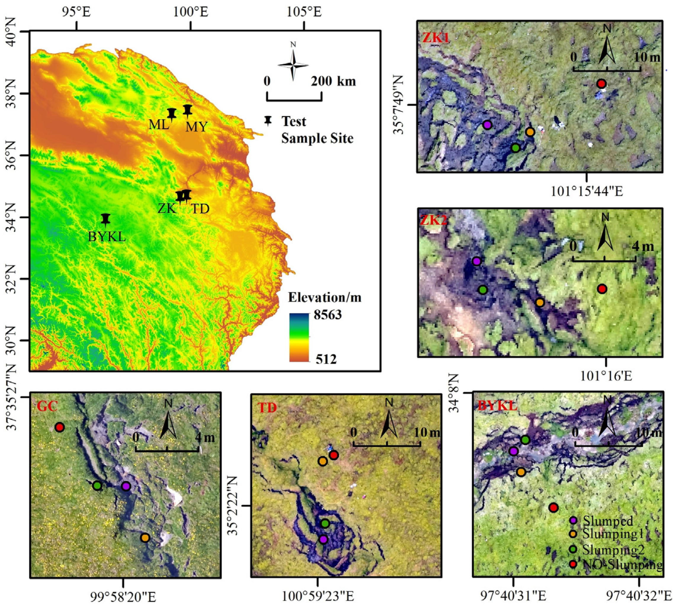
In this study, investigation of TGs was carried out in the northeastern Tibetan Plateau, where the permafrost has undergone remarkable degradation. In this region, the annual precipitation ranges from 200 to 700 mm, and the mean annual temperature ranges from −2.6 °C to −1.4 °C. [38]. A total of 7 different TGs was measured by high-resolution multispectral UAV in 2021 and 2022 (Figure 1 and Figure 2). Soil samples were collected at all TGs. Intensive sampling was conducted in the two typical TGs (EBO1 and EBO2), and the target was to build the training set of the machine learning model (Figure 1). EBO1 was a typical thermo-erosion gully located on the Eboling mountain of the Qilian Mountains (37°28′N, 100°17′E, 3600 m), and EBO2 was another typical thermo-erosion gully located in the EBO1 downstream. The disturbed area of EBO1 was large, mainly due to ground subsidence caused by frequent freeze-thaw cycles, while EBO2 was affected by water erosion and freeze-thaw cycles. The gully width of EBO1 was greater than that of EBO2. On the Eboling mountain, the mean annual precipitation was approximately 460 mm, and the average annual temperature was −3.3 °C. Furthermore, the mean annual temperature in 1981–1989 was 0.82 ± 0.38 °C, which was 1.30 ± 0.49 °C in 1990–1999 and 1.92 ± 0.31 °C in 2000–2009. This value over the three periods increased significantly. Especially after 2000, the mean annual temperature has increased by approximately 1.1 °C compared with that in the 1980s. Due to the isolation and inaccessibility of TGs on the Tibetan Plateau, these unstable TGs—especially EBO1 as many studies have been carried out in this TG—was the thermokarst feature with the longest monitoring period and had the most complete recorded data in the Tibetan Plateau, while the earliest studies were conducted here in the early 1990s. The excess ground ice of the TG was classified as intrusive ice. Permafrost thaw caused by global warming has led to expansion of the gully, which has altered the landscape features and SOC distribution within the TG. During the growing season, a channelized flow occurs along the formed gully from southeast to northwest [32,39]. For the other five TGs (Figure 2), we collected one sample in each landscape of each TG to form the test dataset of the model.
Because the various landscapes within TG at different locations had different soil attributes and SOC contents [23,32], we selected the four most typical regions within EBO1 to show the influence of landscape on SOC content distribution: NO-Slumping, Slumping1, Slumping2, and Slumped. Each landscape had unique characteristics. (1) NO-Slumping (Figure 1A) had scarcely visible subsidence and vegetation removal. This undisturbed landscape was far from the gully formed by subsidence, but its distance from the gully was not fixed. In general, this landscape was at least 10 m away from the boundary of the gully. (2) Slumping1 (Figure 1B) was the most representative landscape of TG and represented the development potential of TG. This landscape was located between the NO-Slumping and Slumped (5–10 m outside of the gully), which was far away from the gully. The soil of Slumping1 had just experienced ground subsidence (had one or more striped cracks). Both the number and the width of the cracks were very low and their surroundings were relatively stable. For example, the depths of cracks in Slumping1 were between 0–60 cm, and their widths were only 10–20 cm or even smaller. Slumping2 (Figure 1C) had the more severe slumping landscape than Slumping1 (<5 m outside of the gully). When the landscape was closer to the gully, the ground subsidence was more serious, the depths and widths of cracks both increased in Slumping2, and the transportation capacity of the channelized flow was stronger in Slumping2, which could bring the surrounding unstable soils into the gully. Therefore, Slumping2 is more broken than Slumping1. (3) Slumped (Figure 1D) was formed after abrupt permafrost collapse and the soil blocks that collapsed from Slumping1 and Slumping2 gathered here and mixed with the exposed mineral soil, which was located inside the gully and incised approximately 0.8–3 m (Figure 1 and Figure S1).

2.2. Data

Since the ground subsidence and freeze-thaw cycles disturbed and mixed the shallow soils of TGs, having significant impacts on their properties [40,41], we collected soil samples at three standard depths: 5 cm,15 cm, and 30 cm—except not for the 0 cm depth because the root system was strongly prevalent in the surface of the undisturbed alpine meadow. Then, we took a weighted average of the obtained covariates and SOC content within the depth interval (5–30 cm) using the trapezoidal rule:
1 m n n m f ( x ) d x 1 m n 1 2 k = 1 N 1 ( x k + 1 x k ) ( f ( x k ) + f ( x k + 1 ) )  
where N is the number of depths, xk is the k-th depth and f(xk) is the value of the target variable at depth xk.
During July and August of 2021 and 2022, a total of 166 soil pits with the above three standard depths were excavated (Table 1). Our principles of pit excavation in EBO1 and EBO2 was to excavate one pit every 10 m for each landscape—few pits were excavated in the Slumped of EBO1 due to the channelized flow in the gully during the growing season. Because it was very difficult to find other TGs in the Tibetan Plateau, 4 pits for each TG were excavated (Figure 2) and the number of pits in each landscape was proportional to its scale.
In addition, the in situ monitoring at each layer of soil volume water content (VWC) and soil temperature (ST) was repeated three times simultaneously (W.E. T Sensor Kit, Cambridge, UK). All soil samples were air-dried, sieved through a 2 mm sieve, handpicked to remove fine roots, homogenized, and divided into three subsamples. The soil texture—i.e., the clay content (<2 μm), silt content (2–50 μm), sand content (50–2000 μm)—was measured using the hydrometer method [42] according to the USDA classification system. The soil pH was measured using an electronic pH meter and a potentiometric method (PB-10, Sartorius, Germany) in H2O. The SOC content was measured using a stable isotope mass spectrometer (Elementar isoprime 100, Hesse, Germany).
We used the DJI P4 Multispectral UAV (DJI Innovations, Shenzhen, China) with a maximum hover accuracy of 2.6 cm in horizontal resolutions in July 2022 to map an orthophoto of the study area. To obtain the optimal images, we set the speed of the UAV to 5 m/s on days with cloud-free conditions and low wind speeds. To ensure the accuracy of the UAV survey, the flying height was set to 50 m, the forward overlap was 70%, and the side overlap was 60%. The dji-terra software (DJI Innovations, Shenzhen, China) was used for 2D reconstruction and to generate vegetation indices for the TG [43,44].
To predict the spatial variability of SOC content in TG, 11 predictors from 4 drivers were considered after eliminating useless variables by combining the correlation analysis and the ranking of relative importance (Figure S2, Table 2). Soil data from the laboratory, including the factors of soil texture and other soil properties were integrated in grid format after interpolation by ordinary kriging [16,45,46] with a spatial resolution of 0.1 m by using ArcMap 10.2 (Environmental Systems Research Institute, Inc., Redlands, CA, USA). In addition, the topographic position index (TPI) and roughness were derived from a digital surface model (DSM). Roughness referred to the variability of terrain surface at a given scale. Grohmann, et al. [47] indicated that the standard deviation of slope was the most effective method to describe the surface roughness, because it was suitable for various fine scales and had excellent and stable performance under almost all geomorphic types. TPI reflected the relative position of a point and other points in the neighborhood, which was equal to the difference between the elevation value of the point and the average elevation value of other points (user-defined) in the neighborhood. The Optimized Soil Adjusted Vegetation Index (OSAVI) uses reflectance in the NIR and red spectrum, was calculated by OSAVI = (NIR–RED)/(NIR + RED + 0.16). And the Normalized Difference Red Edge Index (NDRE) was calculated by NDRE = (NIR–RED EDGE)/(NIR + RED EDGE). All sample selection and information extraction of the factors from UAV images were completed manually in ArcGIS 10.2. The geographic coordinate system was WGS1984(EPSG:4326), and the projection coordinate system was WGS 1984 UTM ZONE 47 N(EPSG:32647).

2.3. Methods

2.3.1. Model Training and Validation

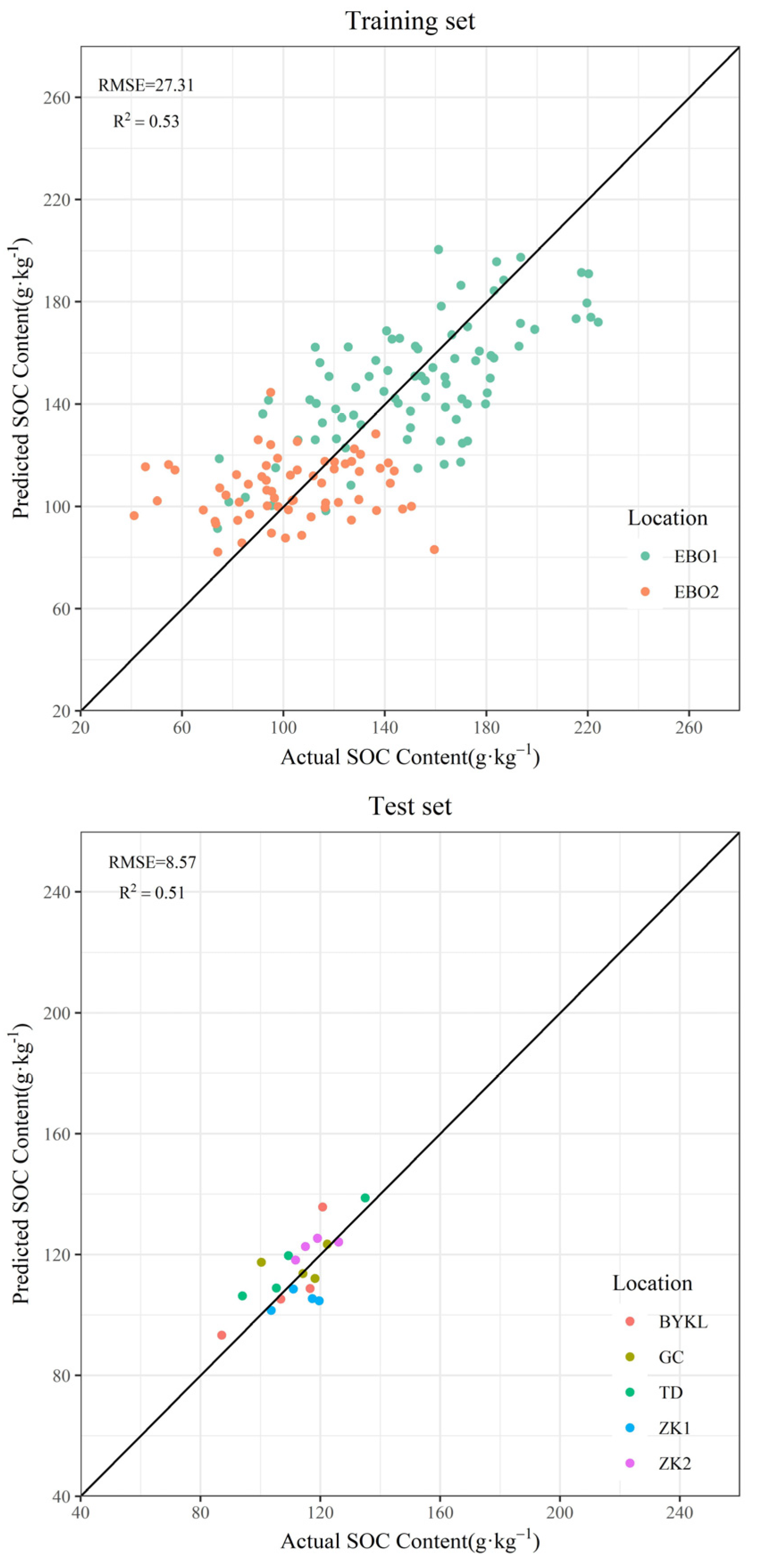
We used the 146 samples (EBO1: 83, EBO2: 63) after weighted averaging within the depth interval as the training dataset, while the 20 samples (GC: 4, ZK1: 4, ZK2: 4, TD: 4, BYKL: 4) were set as the completely independent test dataset (Figure 2). The 10-fold cross validation approach was used to construct and validate the prediction model. In this method, the data were randomly divided into ten equal subsets. In each of the ten folds, the nine subsets were used as the training set, and the other subset was retained for the test data [48]. The selected ML algorithm was repeated 3*10 times to guarantee that all 30 subsets were used once to validate the model, and all cross-validation results were averaged to produce a final accuracy metric. The best ML algorithm was selected based on the above principle. Two accuracy evaluation indicators were used to measure the performance of the model (Formulas (1) and (2)), including the root mean square error (RMSE) and the coefficient of determination (R2):
R M S E = i = 1 n ( P i A i ) 2 n
R 2 = i = 1 n ( P i A ¯ i ) 2 i = 1 n ( A i A ¯ i ) 2
where n is the number of samples; Pi and Ai represent the predicted and actual SOC content values at site i, respectively; and A ¯ i is the average of the actual SOC content values.
All model comparisons and evaluations were conducted by using the “caret” package (https://CRAN.R-project.org/package=caret, accessed on 1 March 2023) in R version 4.2.2 (R: The R Project for Statistical Computing (r-project.org), https://www.r-project.org/). We used the “tidyverse” package for data analysis and visualization (https://www.tidyverse.org/, accessed on 1 March 2023).

2.3.2. Support Vector Machine

The support vector machine (SVM) algorithm is another commonly used supervised ML technique for regression and classification that can handle complex nonlinear patterns using kernel functions [49]. The SVM projects all of the observation data of the original finite-dimensional space into a new hyperspace with much higher dimensions. In the new hyperspace, this technique attempts to construct an optimal hyperplane that achieves the fitting of data and predictors with minimal empirical risk and model complexity or optimally divides them into different classes by leaving the maximum margin between the classes [7]. The commonly used kernel functions include polynomial, sigmoid, and radial basis functions (RBFs). The type and parameters of the kernel function determine the accuracy of the SVM model. The RBF kernel function, which has been widely used and has performed well in previous DSMs [17,50], was selected in this study. Two hyperparameters, the penalty (cost) and the kernel width (sigma), need to be altered for the RBF kernel. We used a customized grid search method to gradually approximate the optimal parameters in the “caret” package of R software. To obtain the final prediction result and evaluate its uncertainty, we used the optimal SVM model based on the leave-one-out method executed 146 times. In each iteration using the leave-one-out method, the model with optimal parameters was selected and validation was performed by using ten-fold cross validation. Then, we produced 146 SOC content maps and calculated the mean and standard deviation (SD) of each pixel as the final map and prediction uncertainty, respectively [51,52].

3. Results

3.1. Model Performance

First, we removed useless covariates for the prediction of SOC content, and the final selected predictors were silt, clay, sand, ST, VWC, pH, red band, OSAVI, NDRE, TPI, and roughness. Then, we used them to build ten different ML models. SVM was the best algorithm for SOC mapping by using UAV image covariates and soil factors in TG after model comparison and evaluation (Figure S3).Since the SVM algorithm is insensitive to multicollinearity and the accuracy of the model constructed by the above 11 predictors decreased after removing factors, we retained all 11 factors in the final model. The 146 soil samples representing soil properties at the 5–30 cm depth interval from two typical TGs in Eboling mountain were used as the training set, while the remaining approximately 10% of soil samples from the other five TGs were used as the completely independent test set. Figure 3 shows the predictive ability of the optimal SVM model in both the training set and the independent test dataset. Our comprehensive accuracy evaluation of the final predicted results relied on ten-fold cross validation, indicating that the performance on the independent test dataset was similar to that on the training set. Specifically, the value of R2 in the test set (0.51) was similar to that in the training set (0.53). The above results showed that the model for SOC prediction based on soil samples from different TGs had good universality and typicality. In the future, we will still need enough samples from other TGs to verify the model.

3.2. Relative Importance of Predictor Variables

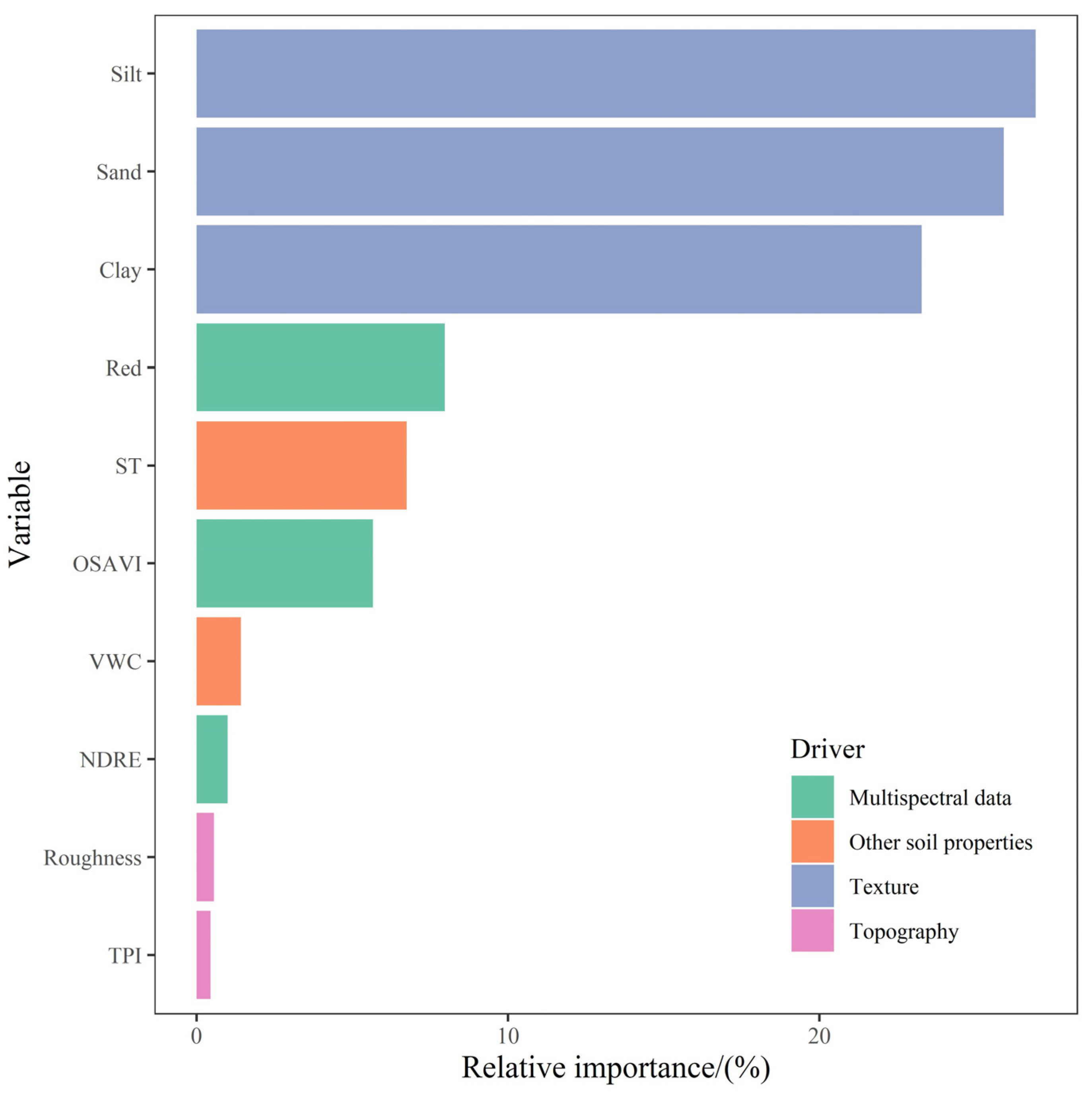
For the SOC content prediction by using the optimal SVM algorithm within different TGs, the rankings of the predictors ordered by relative importance are shown in Figure 4—the importance was converted to a percentage. The relative importance of soil texture, multispectral data, other soil properties (expect for soil texture), and topography accounted for 76.17%, 14.63%, 8.19%, and 1.01%, respectively. The soil texture was the most crucial soil property driving SOC content variability within different TGs in the northeast of the Tibetan Plateau, and the ST, VWC, and pH together showed moderate relevance to SOC content. Remarkably, the selected top six factors together accounted for 96.56 % of SOC content variation, and there were two factors from multispectral data (Red: 7.97%, OSAVI: 5.67%) and one factor from other soil properties (ST: 6.75%).The above results indicated that abrupt thaw in the permafrost not only strongly disturbed the SOC content and other soil properties of the top soils in TGs but also affected the vegetation conditions in the TGs. Specifically, soil texture was the most crucial driver for predicting the SOC content in the TGs with frequent freeze-thaw cycles and channelized flows. The relative importance of the top three predictors was stable. The silt content, sand content, and clay content accounted for 26.95%, 25.93%, and 23.29% of SOC content variation, respectively. As for the last four predictors, the relative importance of them ranged from stable to small, from 0.45% to 1.43% (the relative importance of pH was less than 0.1%, which is not shown in Figure 4), and the total relative importance of the last two microgeomorphologic parameters representing the degree of surface fragmentation was less than 1.01%.

3.3. SOC Content Spatial Prediction Map in Different Landscapes within TG

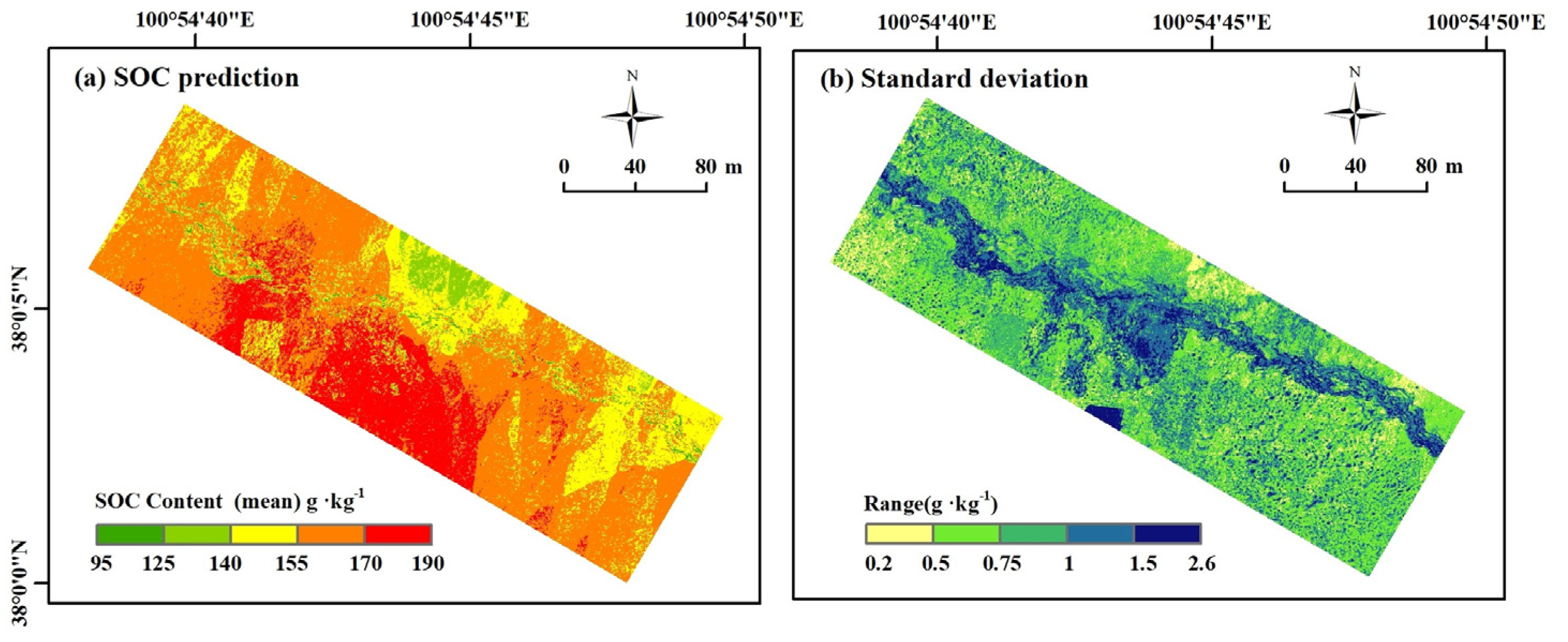
It was more meaningful to discuss the SOC content distribution of TG from the perspective of the landscape. Therefore, we extracted the three most representative landscapes (Figure 1) in the study area, together with the undisturbed soils of the gully, to explore the impact of landscape changes on SOC content distribution within TG. Although the final model overestimated the low values of SOC content, the variation in these values in different landscapes of TG was still found. Specifically, the mean SOC content in the no slumping of the gully was 163.29 ± 9.66 g·kg−1 (Figure 5a), Moreover, the highest SOC contents in our study area (more than 190 g·kg−1) were found in the initial stage of TG on the south bank, mainly concentrated in the middle and southeast of the region. These features had good vegetation conditions. However, its stability was fragile and cracks appeared on the ground surface. Nevertheless, the north-central and northeast of the study region showed the lowest SOC content (less than 155 g/kg). In addition, the morphology and size of landscapes within TG on the south bank were more abundant than those on the north bank, and the three representative landscapes were all on the south bank. Slumping1 was the initial stage of TG, which was far from the gully and experienced ground subsidence, and the mean SOC content in this landscape reached 169.08 ± 9.98 g·kg−1. In contrast, a decrease in SOC content was observed in Slumping2 (150.79 ± 10.9 g·kg−1). Slumping2 was at the edge of the gully, which experienced more severe subsidence than Slumping1 because it was the main disturbance feature in the TGs. For Slumped, a landscape located at the bottom of the gully, had a lower mean SOC content (153 ± 14.94 g·kg−1) to the undisturbed soils on the south bank, and the standard deviation of it was highest. In general, the corresponding uncertainty map (Figure 5b) of TG showed a very low SD value in all landscapes within the TG, which showed the feasibility of the optimal SVM model for SOC prediction in TG (standard deviation between 0.20 and 2.60 g·kg−1).

4. Discussion

4.1. Model Performance

The optimal SVM model performed well in both the training set (R2 = 0.53) and the independent test dataset (R2 = 0.51) from five different TGs, which indicated acceptable operation for SOC prediction at the regional scale by using UAV images and soil properties in this unstable landscape. Compared to previous studies, Yang, et al. [53] predicted the SOC content in cropland soils and found an R2 of 0.51, which was similar to our results. Malone, et al. [54] achieved a lower model accuracy (R2 = 0.10) for the test dataset in predicting SOC content in agricultural soils, and they indicateed that R2 values less than 0.50 were frequently found in the SOC content prediction models. Mirchooli, et al. [55] indicated that the low variation in the SOC content (6.3 ± 2.9 g·kg−1) led to a low evaluation accuracy (R2 = 0.26) of the SOC prediction model. The SOC predictions of Zeraatpisheh and Garosi [56] also confirmed the above conclusion (R2 = 0.35). On the other hand, higher accuracy than our paper was also found [17,57]. For example, Schillaci, et al. [58] obtained an R2 of approximately 0.63 in SOC prediction. In general, the input factors, model choice, calibration method, and scale of the study area all affect the performance of the SOC prediction model. Therefore, model evaluation is particularly important [16,20,59].
A comprehensive comparison of the RMSE and R2 values indicated that the SVM, RF, and MARS algorithms had similar performance in the initial training set (Figure S3). Due to the small computational amount of SVM, the model was not easy to overfit, which was very suitable for SOC prediction at regional or smaller scales [1,40,60]. Ding, Li and Yang [17] evaluated the spatial variations in SOC storage in permafrost to a depth of 3 m in the Qinghai-Tibet Plateau by using a substantial number of pedons (i.e., 342 cores with a depth of 3 m and 177 pits with a depth of 50 cm) with the SVM algorithm. The R2 value of the model driven by six predictors reached 0.63 for a given 10-km spatial resolution. The SOC mapping in Kenya showed that the SVM algorithm performed better than the RF algorithm [46]. Lamichhane, Kumar, and Wilson [20] confirmed this finding. However, these results did not mean that the SVM algorithm showed the best performance in all conditions. For example, Zhou, Geng, and Chen [1] reported that the boosted regression trees (BRT) algorithm outperformed the RF, SVM, and bagged CART algorithms in predicting the SOC content in the southern part of Central Europe by using DEM derivatives and Sentinel-1 and Sentinel-2 data, and they showed that the combination of predictors, the scale, and the required spatial resolution affect the performance of different ML algorithms.Therefore, we proposed using specific experimental datasets to assess competitive predictive models when predicting the SOC contents in different TGs and the SVM was found to be optimal at present.

4.2. Covariate Importance

Soil texture accounted for 76.17% of the SOC variability in which silt, sand, and clay explained 26.95%, 25.93%, and 23.29%, respectively. Previous studies already indicated that the influence of soil texture on SOC is extremely important for soils in nonfrozen areas. Stevens, et al. [61] found that 65.7% of the SOC variability was explained by the soil texture, and our result obtained based on seven different TGs in the northeastern Tibetan Plateau was similar to his. Zeraatpisheh and Garosi [56] also found that soil texture had a significant impact on the spatial variability of SOC when they performed a regional-study in the Darab plain. The research of Ding, Li, and Yang [17] on the Tibetan Plateau also supported our conclusion.Moreover, Zinn, et al. [62] reported that the most important edaphic factor influencing the retention of SOC in aerobic soils was soil texture. Virkkala et al. [63] supported this hypothesis and concluded that the adsorption of colloidal or soluble SOC compounded to higher clay and silt surfaces was a crucial factor stabilizing derivatives from the microbial decomposition of organic debris. Wiesmeier et al. [64] also declared that soil texture was the critical factor regulating SOC content because soil organic matter especially the soil heavy-fraction organic carbon was surrounded by fine particles that prevented it from being attacked by microorganisms [65].
In general, silt showed a positive relationship with SOC variability in our research.This appeared not only in the different regions of EBO1, but also in the different landscapes of the other five TGs used for verification (Figures S4–S8). The positive relationship between the two variables in the unstable permafrost region and non-frozen region showed that the freeze-thaw cycles in TG not only shaped the landscape, but also changed the soil particle size. In other words, the different landscapes in various locations were essentially from the difference in the freeze-thaw cycles times and strengths due to the differentiated environment caused by TG development. More importantly, previous profile-studies in TG on the Tibetan Plateau rarely explained the effect of soil particle size on SOC content. Taking EBO1 as an example, the clay contents were lower in Slumping1 and Slumped than in the NO-Slumping landscape (Figure 6). However, the reasons were different why the clay contents in the two disturbed landscapes were smaller than those in the undisturbed soils (clay content in No-Slumping: 0.59 ± 0.33%). Zhai, et al. [66] found that freeze–thaw cycles could change the shape and size of soil particles. A particle image processor showed that the soil particles initially experienced fragmentation (6 cycles), then aggregation (9 cycles) and eventually fragmentation (50 cycles) in their research. As the initial stage of TG, Slumping1 was rarely mentioned in previous studies on TG, this landscape was far away from the gully and was less affected by the channelized flow. The materials rich in SOC (169.08 ± 9.98 g·kg−1) were exposed to the surface and maintained due to irregular ground subsidence, and the broken top soils were still attached to the undisturbed meadow (No-Slumping: 163.29 ± 9.66 g·kg−1), which meant that the disturbed soil in Slumping1 experienced fewer freeze-thaw cycles, and the fine particle(soil particle size <0.002 mm) matter may experience aggregation (clay content: 0.21 ± 0.05%). Therefore, the clay content reduced, and the silt content increased in the Slumping1. However, the landscape in the gully (Slumped) was determined by the transport capacity and the number of slumped blocks (Figure S9). Specifically, the weak channelized flow could remove the fine particles and the SOC (clay content: 0.39 ± 0.16%) and leave the coarse particles (sand content: 15.08 ± 1.36%). However, the SOC content (153 ± 14.96 g·kg−1) still showed aggregation in the gully compared to Slumping2,because the falling soil blocks from Slumping1 and Slumping2 constantly provide materials rich in organic carbon [27,67]. In contrast, Slumping2 experienced a stronger freeze–thaw disturbance than Slumping1, and the process of particle fragmentation made this landscape have the lowest sand content (13.52 ± 0.05%) and highest clay content (1.14 ± 0.05%). According to the results in the non-frozen region, the higher content of fine particle matter (silt and clay) was helpful for the accumulation of SOC. However, a significant decrease in the silt and SOC content in the 5–30 cm topsoils of Slumping2 was still observed relative to the NO-Slumping soils. Slumping2 was at the edge of the gully. The position of Slumping2 was conducive to the widening and deepening of the crack, which made the disturbed soils inclined to the gully. At this stage, the landscape was still connected with the surrounding meadow. Although the deep soil was exposed, the microbial decomposition and solute transport would consume the SOC materials and take away the fine particles, which only provided limited organic matter (150.79 ± 10.9 g·kg−1). As the transport capacity of the channelized flow in Slumping2 is weaker than that in Slumped, the sand content in Slumping2 is greater than that of Slumped (Figure 6). Overall, the SOC content and the soil particle size in different landscapes were jointly determined by freeze–thaw cycle, microbial decomposition, and the transportation capacity of the channelized flow.
The results revealed that 8.18% of the total SOC variability can be illustrated by other selected soil properties (expected for soil texture). As presented in Figure 4, ST, VWC, and pH of 6.75%, 1.43% and around 0.01%, respectively, had a moderate and weak connection on the SOC content variations among the final 11 factors. ST was an important factor influencing SOC variability, consistent with other studies [68,69]. The reason Kirschbaum [70] explained this result was that the ST was highly sensitive to microbial decomposition of SOC when the temperature increased under low temperature conditions (<10 °C). For the landscapes in EBO1, the mean VWC in the 0–30 cm top-soils was lower at the Slumping than at the NO-Slumping and the Slumped (Figure 6). Moderate VWC promotes the decomposition of SOC matter, and excessively high VWC inhibits microbial decomposition and reduces CO2 production [71,72]; these were the main reasons why the block soils at the gully were rich in carbon (Slumped).
In our study, the SOC content had a weak response to the topography factors (1.01%), in which roughness, and TPI explained 0.56%, and 0.45%, respectively. Topographic factors are driving factors for SOC content variation in local regions, [73]. Local topographic factors control the flow of solutes and sediment, affect water accumulation and discharge, and alter erosional processes [74]. However, the seven different TGs had landscapes with similar properties, which were located at different altitudes, which determined that the influence of the standard terrain parameters such as DSM on SOC variation was weaker than that in a single region, which is the reason we did not choose DSM as the predictior. Previous studies have explained that vegetation cover changes significantly affect SOC accumulation in the topsoil, and an increase in erosion can reduce the stabilization of SOC [17,75,76]. Additionally, multispectral data were crucial driving forces for SOC variability, multispectral data accounted for 14.63% of the SOC variability in which Red, OSAVI, and NDRE explained 7.97%, 5.67%, and 0.99%, respectively. Moderate and weak correlations were detected between the predictors and SOC content in our study. In the four different landscapes within EBO1, OSAVI values decreased with the severity of TG development. This meant that the closer to the gully, the less vegetation there was and the more the permafrost was disturbed by ground subsidence and channelized water flow.The above results could be attributed to abrupt permafrost thawing having a greater impact on soil texture and hydrological conditions than vegetation. For example, although Slumping1 and Slumping2 had similar spectral characteristics, the SOC content and other drivers were very different.

4.3. SOC Content Spatial Prediction Map in Different Landscapes within TG

In general, the mean SOC content of the 5–30 cm topsoils in the TG of EBO1 varied from approximately 95 g·kg−1 to more than 190 g·kg−1 (Figure 5a). In addition, the standard deviation (between 0.20 and 2.60 g·kg−1) of the predicted map was low (right panel), showing the reliability of the final predicted results. Almost all of the highest values of uncertainty were associated with the highest SOC content. EBO1 was located in a cold region with an altitude of approximately 3600 m, and the SOC content of permafrost appeared to be high for a region with an average annual precipitation of approximately 460 mm and an average annual temperature of −3.3 °C. High permafrost carbon content could be attributed to the remnant of biological accumulation in in these frozen soils over thousands of years [35]. However, global warming weakens the inhibitory effect of frozen soil on microorganism activity. Our research area was vulnerable to climate warming given that it is located at the lower boundary of the permafrost. Therefore, the permafrost attributes and transport capacity together dominated the landscapes and SOC content distribution in this unstable and warm upland permafrost [77,78,79]. The previous profile-scale studies on the same TG and our results on the other five TGs further proved the rationality of the above results [32,39,67,80]. Abrupt permafrost thawing could alter the soil environment, shape landscape features, and influence the distribution of soil matter rich in SOC.
Significantly, the location of the landscapes in the TG could be the main reason for the changes in soil factors on a regional scale in the context of climate change. In general, the conditions of disturbed soils and the transport capacity together determined the SOC distribution within the gully.The farther away from the gully, the less the subsurface ice-rich soil from deeper layers was exposed, which meant that the protective effect of vegetation and soil remained and the SOC materials could be kept stably in their original position [81,82,83]. On the one hand, when the landscape was closer to the gully, the ground subsidence was more obvious with a decreasing OSAVI (NO-Slumping > Slumping1 > Slunping2 > Slumped); on the other hand, TG formed as a result of heat transfer from channelized flow of melting ground water into permafrost, resulting in the frozen soil thawing and the redistribution of water [24]. Processes such as thermo-erosional sinkholes, and tunnel development, could develop large gully networks [81,82], which were incised 0–0.86 m in our research (roughness: NO-Slumping < Slumping1 < Slunping2 < Slumped), and the incised terrain and exposed mineral soils tended to experience water accumulation rather than evaporation. Therefore, the value of VWC was gradually closer to the initial landscape or even higher in Slumping2 and Slumped. Although the lower TPI and roughness were helpful to accumulate soluble salts, the channelized flow took away some collapsed materials. The above results indicated that abrupt permafrost thawing significantly affected soil physical properties in the TG, thus ultimately influencing the SOC content distribution over space [84].
To understand the carbon change at different positions of TG it is necessary to note that the net SOC content in permafrost is the input minus the loss [16]. In TG, freeze-thaw cycles and the transport capacity of the channelized flow both affected the amount of SOC content. On the one hand, studies on the Tibetan Plateau and circumpolar regions both showed that the dissolved organic carbon (DOC) from TG could easily be leached from the disturbed permafrost and decomposed by microorganisms in the Slumping landscape [35,67,85]. In our study, Slumping2 could expose the permafrost previously protected by vegetation and activate the decomposition of microorganisms, causing organic matter loss, while the Slumped was considered a limited landscape feature of TG since its preferential positions for landscape development were likely to already lack permafrost in warmer permafrost zones [27]. Therefore, the widening rate of the gully slowed down, and the limited channelized flow could remove only the fine particles and a tiny fraction of the soil materials (Figure S9) due to their limited transportation capacity [72,79]. In other words, the broken and exposed permafrost in Slumped landscape could obtain soil organic matter easily dissolved in melting water from Slumping landscape during abrupt permafrost thawing due to the low terrain, and the soils from disturbed landscapes (Slumped) had higher light-fraction organic carbon which was easy to decompose [67]. The exposed soil organic material of topsoils could also experience photodegradation since it was sensitive to light [84]. At the initial stage of TG which underwent limited freeze-thaw cycles, one or more striped cracks emerged in the surrounding meadow when abrupt permafrost thaw occurred. The vegetation condition was still good and there was no damage to the soil structure on the side of the crack which was shorter to the gully. Cracks with widths of only 10–20 cm were conducive to expose SOC-rich substances to the surface, but not to lose them. When the soil around the crack was broken, the overlapping of the disturbed permafrost in the top soils reshaped the SOC in Slumping1.

5. Conclusions

Along with advances in UAV techniques, SOC mapping has gained unprecedented improvement at the local scale. As a typical thermokarst feature on a regional scale, the carbon distribution of TGs has important significance under global warming. It is necessary to assess the soil organic carbon content in the TGs. In our research, a combination of soil characteristics obtained from field investigation and the associated covariates extracted from UAV images were taken into consideration, and after model selection, an optimal SVM algorithm was used to predict the spatial variation in SOC content within TG. Overall, the final model could explain 53.06% (R2) of the SOC content variation in the training set, and this value was 0.51 in the independent test dataset. Soil texture was the most crucial driver affecting SOC content variation. Moreover, the positive correlation between silt and SOC content in different TGs was confirmed in the four landscapes within EBO1 and other five TGs from the Tibetan Plateau. Given the difficulty of large-scale surveys for TGs in the Tibetan Plateau, this conclusion is very representative but still needs further exploration. The results also found that the UAV covariates had a moderate influence on SOC mapping, which showed the feasibility of using UAV images in SOC mapping at the local and regional scales. However, in this study, covariates from UAV did not perform as well as soil texture. The carbon distribution is related to the landscape of TG, and the severe slumping landscape (Slumping2) had a lower SOC content than the NO-Slumped landscape and initial slumping landscape (Slumping1) due to microbial decomposition and photodegradation. The SOC content of the Slumped landscape was similar to that of the NO-Slumped landscape due to the accumulation of permafrost collapse materials and limited transport capacity. In addition, the SOC contents in Slumping1 were higher than the SOC contents in undisturbed soils because the protective effect of frozen soil and vegetation on SOC materials was weakened when the permafrost collapse was initiated and the freeze–thaw cycle intensified. In general, it is extremely important to use UAVs to acquire multitemporal images to extract further covariates, even three-dimensional data, to monitor the impact of landscape changes in more TGs on SOC content variation and their driving forces.

Supplementary Materials

The following supporting information can be downloaded at: https://www.mdpi.com/article/10.3390/rs15061628/s1.

Author Contributions

Conceptualization, X.L. and M.D.; methodology, M.D. and Z.J.; software, M.D. and Z.J.; validation, X.L. and M.D.; formal analysis, M.D. and Z.J.; investigation, M.D. and Z.J.; resources, X.L.; data curation, X.L.; writing—original draft preparation, M.D.; writing—review and editing, X.L. and M.D.; visualization, M.D.; supervision, X.L.; project administration, X.L.; funding acquisition, X.L. All authors have read and agreed to the published version of the manuscript.

Funding

This research was funded by the second Tibetan Plateau Scientific Expedition and Research Program (STEP, grant 2019QZKK0306).

Data Availability Statement

Not applicable.

Acknowledgments

We want to thank Zhenxia Ji of the Northwest Agricultural and Forestry University for support during visualization. We also want to thank Xin Liu, Yuanhong Deng, Qiwen Liao, and Fangzhong Shi of Beijing Normal University for support during soil sample collection.

Conflicts of Interest

The authors declare no conflict of interest. The funders had no role in the design of the study; in the collection, analyses, or interpretation of data; in the writing of the manuscript; or in the decision to publish the results.

References

  1. Zhou, T.; Geng, Y.; Chen, J. High-resolution digital mapping of soil organic carbon and soil total nitrogen using DEM derivatives, Sentinel-1 and Sentinel-2 data based on machine learning algorithms. Sci. Total. Environ. 2020, 729, 138244. [Google Scholar] [CrossRef]
  2. Sothe, C.; Gonsamo, A.; Arabian, J.; Snider, J. Large scale mapping of soil organic carbon concentration with 3D machine learning and satellite observations. Geoderma 2022, 405. [Google Scholar] [CrossRef]
  3. Hoffmann, M.; Pohl, M.; Jurisch, N.; Prescher, A.K.; Mendez Campa, E.; Hagemann, U.; Remus, R.; Verch, G.; Sommer, M.; Augustin, J. Maize carbon dynamics are driven by soil erosion state and plant phenology rather than nitrogen fertilization form. Soil Tillage Res. 2018, 175, 255–266. [Google Scholar] [CrossRef]
  4. Forkuor, G.; Hounkpatin, O.K.; Welp, G.; Thiel, M. High Resolution Mapping of Soil Properties Using Remote Sensing Variables in South-Western Burkina Faso: A Comparison of Machine Learning and Multiple Linear Regression Models. PLoS ONE 2017, 12, e0170478. [Google Scholar] [CrossRef] [Green Version]
  5. Khaledian, Y.; Miller, B.A. Selecting appropriate machine learning methods for digital soil mapping. Appl. Math. Model. 2020, 81, 401–418. [Google Scholar] [CrossRef]
  6. Hinge, G.; Surampalli, R.Y.; Goyal, M.K. Prediction of soil organic carbon stock using digital mapping approach in humid India. Environ. Earth Sci. 2018, 77, 172. [Google Scholar] [CrossRef]
  7. Maynard, J.J.; Levi, M.R. Hyper-temporal remote sensing for digital soil mapping: Characterizing soil-vegetation response to climatic variability. Geoderma 2017, 285, 94–109. [Google Scholar] [CrossRef] [Green Version]
  8. Gholizadeh, A.; Žižala, D.; Saberioon, M.; Borůvka, L. Soil organic carbon and texture retrieving and mapping using proximal, airborne and Sentinel-2 spectral imaging. Remote Sens. Environ. 2018, 218, 89–103. [Google Scholar] [CrossRef]
  9. Mosleh, Z.; Salehi, M.H.; Jafari, A.; Borujeni, I.E.; Mehnatkesh, A. The effectiveness of digital soil mapping to predict soil properties over low-relief areas. Environ. Monit Assess 2016, 188, 1–13. [Google Scholar] [CrossRef]
  10. Gomes, L.C.; Faria, R.M.; de Souza, E.; Veloso, G.V.; Schaefer, C.E.G.R.; Filho, E.I.F. Modelling and mapping soil organic carbon stocks in Brazil. Geoderma 2019, 340, 337–350. [Google Scholar] [CrossRef]
  11. Rentschler, T.; Werban, U.; Ahner, M.; Behrens, T.; Gries, P.; Scholten, T.; Teuber, S.; Schmidt, K. 3D mapping of soil organic carbon content and soil moisture with multiple geophysical sensors and machine learning. Vadose Zone J. 2020, 19, e20062. [Google Scholar] [CrossRef]
  12. Heung, B.; Bulmer, C.E.; Schmidt, M.G. Predictive soil parent material mapping at a regional-scale: A Random Forest approach. Geoderma 2014, 214, 141–154. [Google Scholar] [CrossRef]
  13. McBratney, A.B.; Mendonça Santos, M.L.; Minasny, B. On digital soil mapping. Geoderma 2003, 117, 3–52. [Google Scholar] [CrossRef]
  14. Song, X.D.; Yang, F.; Wu, H.Y.; Zhang, J.; Li, D.C.; Liu, F.; Zhao, Y.G.; Yang, J.L.; Ju, B.; Cai, C.F.; et al. Significant loss of soil inorganic carbon at the continental scale. Natl. Sci. Rev. 2022, 9, nwab120. [Google Scholar] [CrossRef] [PubMed]
  15. Wiesmeier, M.; Urbanski, L.; Hobley, E.; Lang, B.; von Lützow, M.; Marin-Spiotta, E.; van Wesemael, B.; Rabot, E.; Ließ, M.; Garcia-Franco, N.; et al. Soil organic carbon storage as a key function of soils–A review of drivers and indicators at various scales. Geoderma 2019, 333, 149–162. [Google Scholar] [CrossRef]
  16. Hamzehpour, N.; Shafizadeh-Moghadam, H.; Valavi, R. Exploring the driving forces and digital mapping of soil organic carbon using remote sensing and soil texture. Catena 2019, 182, 104141. [Google Scholar] [CrossRef]
  17. Ding, J.; Li, F.; Yang, G. The permafrost carbon inventory on the Tibetan Plateau: A new evaluation using deep sediment cores. Glob. Chang. Biol. 2016, 22, 2688–2701. [Google Scholar] [CrossRef] [Green Version]
  18. Yang, L.; Song, M.; Zhu, A.X.; Qin, C.; Zhou, C.; Qi, F.; Li, X.; Chen, Z.; Gao, B. Predicting soil organic carbon content in croplands using crop rotation and Fourier transform decomposed variables. Geoderma 2019, 340, 289–302. [Google Scholar] [CrossRef]
  19. Hounkpatin, O.K.L.; Op de Hipt, F.; Bossa, A.Y.; Welp, G.; Amelung, W. Soil organic carbon stocks and their determining factors in the Dano catchment (Southwest Burkina Faso). Catena 2018, 166, 298–309. [Google Scholar] [CrossRef]
  20. Lamichhane, S.; Kumar, L.; Wilson, B. Digital soil mapping algorithms and covariates for soil organic carbon mapping and their implications: A review. Geoderma 2019, 352, 395–413. [Google Scholar] [CrossRef]
  21. Siewert, M.B. High-resolution digital mapping of soil organic carbon in permafrost terrain using machine learning: A case study in a sub-Arctic peatland environment. Biogeosciences 2018, 15, 1663–1682. [Google Scholar] [CrossRef] [Green Version]
  22. Wang, D.; Wu, T.; Zhao, L.; Mu, C.; Li, R.; Wei, X.; Hu, G.; Zou, D.; Zhu, X.; Chen, J.; et al. A 1 km resolution soil organic carbon dataset for frozen ground in the Third Pole. Earth Syst. Sci. Data 2021, 13, 3453–3465. [Google Scholar] [CrossRef]
  23. Abbott, B.W.; Jones, J.B. Permafrost collapse alters soil carbon stocks, respiration, CH4, and N2O in upland tundra. Glob. Chang. Biol. 2015, 21, 4570–4587. [Google Scholar] [CrossRef] [PubMed]
  24. Jensen, A.E.; Lohse, K.A.; Crosby, B.T.; Mora, C.I. Variations in soil carbon dioxide efflux across a thaw slump chronosequence in northwestern Alaska. Environ. Res. Lett. 2014, 9, 025001. [Google Scholar] [CrossRef] [Green Version]
  25. Schädel, C.; Bader, M.K.F.; Schuur, E.A.G.; Biasi, C.; Bracho, R.; Čapek, P.; De Baets, S.; Diáková, K.; Ernakovich, J.; Estop-Aragones, C.; et al. Potential carbon emissions dominated by carbon dioxide from thawed permafrost soils. Nat. Clim. Chang. 2016, 6, 950–953. [Google Scholar] [CrossRef]
  26. Kokelj, S.V.; Jorgenson, M.T. Advances in Thermokarst Research. Permafr. Periglac. Process. 2013, 24, 108–119. [Google Scholar] [CrossRef]
  27. Olefeldt, D.; Goswami, S.; Grosse, G.; Hayes, D.; Hugelius, G.; Kuhry, P.; McGuire, A.D.; Romanovsky, V.E.; Sannel, A.B.; Schuur, E.A.; et al. Circumpolar distribution and carbon storage of thermokarst landscapes. Nat. Commun. 2016, 7, 13043. [Google Scholar] [CrossRef] [Green Version]
  28. Mu, C.C.; Abbott, B.W.; Wu, X.D.; Zhao, Q.; Wang, H.J.; Su, H.; Wang, S.F.; Gao, T.G.; Guo, H.; Peng, X.Q.; et al. Thaw Depth Determines Dissolved Organic Carbon Concentration and Biodegradability on the Northern Qinghai-Tibetan Plateau. Geophys. Res. Lett. 2017, 44, 9389–9399. [Google Scholar] [CrossRef]
  29. Jones, B.M.; Grosse, G.; Arp, C.D.; Jones, M.C.; Walter Anthony, K.M.; Romanovsky, V.E. Modern thermokarst lake dynamics in the continuous permafrost zone, northern Seward Peninsula, Alaska. J. Geophys. Res. 2011, 116, 1–13. [Google Scholar] [CrossRef]
  30. Deng, Y.; Li, X.; Shi, F.; Chai, L.; Zhao, S.; Ding, M.; Liao, Q. Nonlinear effects of thermokarst lakes on peripheral vegetation greenness across the Qinghai-Tibet Plateau using stable isotopes and satellite detection. Remote Sens. Environ. 2022, 280, 113215. [Google Scholar] [CrossRef]
  31. Gao, T.; Zhang, Y.; Kang, S.; Abbott, B.W.; Wang, X.; Zhang, T.; Yi, S.; Gustafsson, Ö. Accelerating permafrost collapse on the eastern Tibetan Plateau. Environ. Res. Lett. 2021, 16, 054023. [Google Scholar] [CrossRef]
  32. Xu, H.; Liu, G.; Wu, X.; Smoak, J.M.; Mu, C.; Ma, X.; Zhang, X.; Li, H.; Hu, G. Soil enzyme response to permafrost collapse in the Northern Qinghai-Tibetan Plateau. Ecol. Indic. 2018, 85, 585–593. [Google Scholar] [CrossRef]
  33. Yang, G.; Peng, Y.; Marushchak, M.E.; Chen, Y.; Wang, G.; Li, F.; Zhang, D.; Wang, J.; Yu, J.; Liu, L.; et al. Magnitude and Pathways of Increased Nitrous Oxide Emissions from Uplands Following Permafrost Thaw. Environ. Sci. Technol. 2018, 52, 9162–9169. [Google Scholar] [CrossRef] [PubMed]
  34. Nitzbon, J.; Westermann, S.; Langer, M.; Martin, L.C.P.; Strauss, J.; Laboor, S.; Boike, J. Fast response of cold ice-rich permafrost in northeast Siberia to a warming climate. Nat. Commun. 2020, 11, 2201. [Google Scholar] [CrossRef]
  35. Schuur, E.A.; McGuire, A.D.; Schadel, C.; Grosse, G.; Harden, J.W.; Hayes, D.J.; Hugelius, G.; Koven, C.D.; Kuhry, P.; Lawrence, D.M.; et al. Climate change and the permafrost carbon feedback. Nature 2015, 520, 171–179. [Google Scholar] [CrossRef] [PubMed]
  36. Loiko, S.V.; Pokrovsky, O.S.; Raudina, T.V.; Lim, A.; Kolesnichenko, L.G.; Shirokova, L.S.; Vorobyev, S.N.; Kirpotin, S.N. Abrupt permafrost collapse enhances organic carbon, CO2, nutrient and metal release into surface waters. Chem. Geol. 2017, 471, 153–165. [Google Scholar] [CrossRef]
  37. Mu, C.; Zhang, T.; Zhang, X.; Li, L.; Guo, H.; Zhao, Q.; Cao, L.; Wu, Q.; Cheng, G. Carbon loss and chemical changes from permafrost collapse in the northern Tibetan Plateau. J. Geophys. Res. Biogeosci. 2016, 121, 1781–1791. [Google Scholar] [CrossRef]
  38. Zhao, L.; Zou, D.; Hu, G.; Du, E.; Pang, Q.; Xiao, Y.; Li, R.; Sheng, Y.; Wu, X.; Sun, Z.; et al. Changing climate and the permafrost environment on the Qinghai–Tibet (Xizang) plateau. Permafr. Periglac. Process. 2020, 31, 396–405. [Google Scholar] [CrossRef]
  39. Yang, G.; Peng, Y.; Olefeldt, D.; Chen, Y.; Wang, G.; Li, F.; Zhang, D.; Wang, J.; Yu, J.; Liu, L.; et al. Changes in Methane Flux along a Permafrost Thaw Sequence on the Tibetan Plateau. Environ. Sci. Technol. 2018, 52, 1244–1252. [Google Scholar] [CrossRef]
  40. Wang, T.; Yang, D.; Yang, Y.; Piao, S.; Li, X.; Cheng, G.; Fu, B. Permafrost thawing puts the frozen carbon at risk over the Tibetan Plateau. Sci. Adv. 2020, 6, eaaz3513. [Google Scholar] [CrossRef]
  41. Wu, Q.; Zhang, T. Changes in active layer thickness over the Qinghai-Tibetan Plateau from 1995 to 2007. J. Geophys. Res. 2010, 115, D09107. [Google Scholar] [CrossRef]
  42. Cui, P.; Chen, Z.; Fan, F.; Yin, C.; Song, A.; Li, T.; Zhang, H.; Liang, Y. Soil texture is an easily overlooked factor affecting the temperature sensitivity of N(2)O emissions. Sci. Total. Environ. 2023, 862, 160648. [Google Scholar] [CrossRef]
  43. Gao, Z.; Hu, X.; Li, X.-Y.; Li, Z.-C. Effects of freeze-thaw cycles on soil macropores and its implications on formation of hummocks in alpine meadows in the Qinghai Lake watershed, northeastern Qinghai-Tibet Plateau. J. Soils Sediments 2020, 21, 245–256. [Google Scholar] [CrossRef]
  44. Zhang, F.; Hu, Z.; Fu, Y.; Yang, K.; Wu, Q.; Feng, Z. A New Identification Method for Surface Cracks from UAV Images Based on Machine Learning in Coal Mining Areas. Remote Sens. 2020, 12, 1571. [Google Scholar] [CrossRef]
  45. Chaplot, V.; Bouahom, B.; Valentin, C. Soil organic carbon stocks in Laos: Spatial variations and controlling factors. Glob. Chang. Biol. 2010, 16, 1380–1393. [Google Scholar] [CrossRef]
  46. Were, K.; Bui, D.T.; Dick, Ø.B.; Singh, B.R. A comparative assessment of support vector regression, artificial neural networks, and random forests for predicting and mapping soil organic carbon stocks across an Afromontane landscape. Ecol. Indic. 2015, 52, 394–403. [Google Scholar] [CrossRef]
  47. Grohmann, C.H.; Smith, M.J.; Riccomini, C. Multiscale Analysis of Topographic Surface Roughness in the Midland Valley, Scotland. IEEE Trans. Geosci. Remote Sens. 2011, 49, 1200–1213. [Google Scholar] [CrossRef] [Green Version]
  48. Aitkenhead, M.J. Mapping peat in Scotland with remote sensing and site characteristics. Eur. J. Soil Sci. 2017, 68, 28–38. [Google Scholar] [CrossRef] [Green Version]
  49. Katoch, S.; Chauhan, S.S.; Kumar, V. A review on genetic algorithm: Past, present, and future. Multimed. Tools Appl. 2021, 80, 8091–8126. [Google Scholar] [CrossRef]
  50. Taghizadeh-Mehrjardi, R.; Minasny, B.; Sarmadian, F.; Malone, B.P. Digital mapping of soil salinity in Ardakan region, central Iran. Geoderma 2014, 213, 15–28. [Google Scholar] [CrossRef]
  51. Jeong, G.Y.; Oeverdieck, H.; Park, S.J.; Huwe, B.; Liess, M. Spatial soil nutrients prediction using three supervised learning methods for assessment of land potentials in complex terrain. Catena 2017, 154, 73–84. [Google Scholar] [CrossRef]
  52. Zhang, Y.; Yang, W.; Sun, Y.; Chang, C.; Yu, J.; Zhang, W. Fusion of Multispectral Aerial Imagery and Vegetation Indices for Machine Learning-Based Ground Classification. Remote Sens. 2021, 13, 1411. [Google Scholar] [CrossRef]
  53. Yang, L.; He, X.; Shen, F.; Zhou, C.; Zhu, A.X.; Gao, B.; Chen, Z.; Li, M. Improving prediction of soil organic carbon content in croplands using phenological parameters extracted from NDVI time series data. Soil Tillage Res. 2020, 196, 104465. [Google Scholar] [CrossRef]
  54. Malone, B.P.; McBratney, A.B.; Minasny, B.; Laslett, G.M. Mapping continuous depth functions of soil carbon storage and available water capacity. Geoderma 2009, 154, 138–152. [Google Scholar] [CrossRef]
  55. Mirchooli, F.; Kiani-Harchegani, M.; Khaledi Darvishan, A.; Falahatkar, S.; Sadeghi, S.H. Spatial distribution dependency of soil organic carbon content to important environmental variables. Ecol. Indic. 2020, 116, 106473. [Google Scholar] [CrossRef]
  56. Zeraatpisheh, M.; Garosi, Y. Improving the spatial prediction of soil organic carbon using environmental covariates selection: A comparison of a group of environmental covariates. Catena 2022, 208, 105723. [Google Scholar] [CrossRef]
  57. Yang, R.-M.; Zhang, G.-L.; Liu, F.; Lu, Y.-Y.; Yang, F.; Yang, F.; Yang, M.; Zhao, Y.-G.; Li, D.-C. Comparison of boosted regression tree and random forest models for mapping topsoil organic carbon concentration in an alpine ecosystem. Ecol. Indic. 2016, 60, 870–878. [Google Scholar] [CrossRef]
  58. Schillaci, C.; Acutis, M.; Lombardo, L.; Lipani, A.; Fantappie, M.; Marker, M.; Saia, S. Spatio-temporal topsoil organic carbon mapping of a semi-arid Mediterranean region: The role of land use, soil texture, topographic indices and the influence of remote sensing data to modelling. Sci. Total. Environ. 2017, 601–602, 821–832. [Google Scholar] [CrossRef]
  59. Zeng, C.Y.; Yang, L.; Zhu, A.X.; Rossiter, D.G.; Liu, J.; Liu, J.Z.; Qin, C.Z.; Wang, D.S. Mapping soil organic matter concentration at different scales using a mixed geographically weighted regression method. Geoderma 2016, 281, 69–82. [Google Scholar] [CrossRef]
  60. Wang, Y.; Wang, S.; Xu, M. Landscape Perception Identification and Classification Based on Electroencephalogram (EEG) Features. Int. J. Environ. Res. Public Health 2022, 19, 629. [Google Scholar] [CrossRef]
  61. Stevens, F.; Bogaert, P.; van Wesemael, B. Detecting and quantifying field-related spatial variation of soil organic carbon using mixed-effect models and airborne imagery. Geoderma 2015, 259, 93–103. [Google Scholar] [CrossRef]
  62. Zinn, Y.L.; Lal, R.; Bigham, J.M.; Resck, D.V.S. Edaphic Controls on Soil Organic Carbon Retention in the Brazilian Cerrado: Texture and Mineralogy. Soil Sci. Soc. Am. J. 2007, 71, 1204–1214. [Google Scholar] [CrossRef]
  63. Virkkala, A.M.; Aalto, J.; Rogers, B.M.; Tagesson, T.; Treat, C.C.; Natali, S.M.; Watts, J.D.; Potter, S.; Lehtonen, A.; Mauritz, M.; et al. Statistical upscaling of ecosystem CO2 fluxes across the terrestrial tundra and boreal domain: Regional patterns and uncertainties. Glob. Chang. Biol. 2021, 27, 4040–4059. [Google Scholar] [CrossRef] [PubMed]
  64. Wiesmeier, M.; Spörlein, P.; Geuß, U.; Hangen, E.; Haug, S.; Reischl, A.; Schilling, B.; Lützow, M.; Kögel-Knabner, I. Soil organic carbon stocks in southeast Germany (Bavaria) as affected by land use, soil type and sampling depth. Glob. Chang. Biol. 2012, 18, 2233–2245. [Google Scholar] [CrossRef]
  65. Zhang, F.; Zhang, K.; Li, Y.; Qin, R.; Hou, M.; Li, M.; Zhang, W.; Li, F.-M. A deeper look at crop residue and soil warming impact on the soil C pools. Soil Tillage Res. 2022, 215, 105192. [Google Scholar] [CrossRef]
  66. Zhai, J.; Zhang, Z.; Melnikov, A.; Zhang, M.; Yang, L.; Jin, D. Experimental Study on the Effect of Freeze—Thaw Cycles on the Mineral Particle Fragmentation and Aggregation with Different Soil Types. Minerals 2021, 11, 913. [Google Scholar] [CrossRef]
  67. Mu, C.C.; Abbott, B.W.; Zhao, Q.; Su, H.; Wang, S.F.; Wu, Q.B.; Zhang, T.J.; Wu, X.D. Permafrost collapse shifts alpine tundra to a carbon source but reduces N2O and CH4 release on the northern Qinghai-Tibetan Plateau. Geophys. Res. Lett. 2017, 44, 8945–8952. [Google Scholar] [CrossRef]
  68. Guo, P.-T.; Li, M.-F.; Luo, W.; Tang, Q.-F.; Liu, Z.-W.; Lin, Z.-M. Digital mapping of soil organic matter for rubber plantation at regional scale: An application of random forest plus residuals kriging approach. Geoderma 2015, 237–238, 49–59. [Google Scholar] [CrossRef]
  69. Meier, I.C.; Leuschner, C. Variation of soil and biomass carbon pools in beech forests across a precipitation gradient. Glob. Chang. Biol. 2010, 16, 1035–1045. [Google Scholar] [CrossRef]
  70. Kirschbaum, M.U.F. THE TEMPERATURE-DEPENDENCE OF SOIL ORGANIC-MATTER DECOMPOSITION, AND THE EFFECT OF GLOBAL WARMING ON SOIL ORGANIC-C STORAGE. Soil Biol. Biochem. 1995, 27, 753–760. [Google Scholar] [CrossRef]
  71. Beamish, A.; Neil, A.; Wagner, I.; Scott, N.A. Short-term impacts of active layer detachments on carbon exchange in a High Arctic ecosystem, Cape Bounty, Nunavut, Canada. Polar Biol. 2014, 37, 1459–1468. [Google Scholar] [CrossRef]
  72. Harden, J.W.; Koven, C.D.; Ping, C.-L.; Hugelius, G.; David McGuire, A.; Camill, P.; Jorgenson, T.; Kuhry, P.; Michaelson, G.J.; O’Donnell, J.A.; et al. Field information links permafrost carbon to physical vulnerabilities of thawing. Geophys. Res. Lett. 2012, 39, L15704. [Google Scholar] [CrossRef] [Green Version]
  73. Hobley, E.; Wilson, B.; Wilkie, A.; Gray, J.; Koen, T. Drivers of soil organic carbon storage and vertical distribution in Eastern Australia. Plant Soil 2015, 390, 111–127. [Google Scholar] [CrossRef]
  74. Li, Q.-Q.; Yue, T.-X.; Wang, C.-Q.; Zhang, W.-J.; Yu, Y.; Li, B.; Yang, J.; Bai, G.-C. Spatially distributed modeling of soil organic matter across China: An application of artificial neural network approach. Catena 2013, 104, 210–218. [Google Scholar] [CrossRef]
  75. Gray, J.M.; Bishop, T.F.A.; Wilson, B.R. Factors Controlling Soil Organic Carbon Stocks with Depth in Eastern Australia. Soil Sci. Soc. Am. J. 2015, 79, 1741–1751. [Google Scholar] [CrossRef] [Green Version]
  76. Minasny, B.; McBratney, A.B.; Mendonca-Santos, M.L.; Odeh, I.O.A.; Guyon, B. Prediction and digital mapping of soil carbon storage in the Lower Namoi Valley. Aust. J. Soil Res. 2006, 44, 233–244. [Google Scholar] [CrossRef]
  77. Koven, C.D.; Ringeval, B.; Friedlingstein, P.; Ciais, P.; Cadule, P.; Khvorostyanov, D.; Krinner, G.; Tarnocai, C. Permafrost carbon-climate feedbacks accelerate global warming. Proc. Natl. Acad. Sci. USA 2011, 108, 14769–14774. [Google Scholar] [CrossRef] [Green Version]
  78. Mack, M.C.; Bret-Harte, M.S.; Hollingsworth, T.N.; Jandt, R.R.; Schuur, E.A.; Shaver, G.R.; Verbyla, D.L. Carbon loss from an unprecedented Arctic tundra wildfire. Nature 2011, 475, 489–492. [Google Scholar] [CrossRef]
  79. Treat, C.C.; Natali, S.M.; Ernakovich, J.; Iversen, C.M.; Lupascu, M.; McGuire, A.D.; Norby, R.J.; Roy Chowdhury, T.; Richter, A.; Santruckova, H.; et al. A pan-Arctic synthesis of CH4 and CO2 production from anoxic soil incubations. Glob. Chang. Biol. 2015, 21, 2787–2803. [Google Scholar] [CrossRef]
  80. Mu, C.; Abbott, B.W.; Norris, A.J.; Mu, M.; Fan, C.; Chen, X.; Jia, L.; Yang, R.; Zhang, T.; Wang, K.; et al. The status and stability of permafrost carbon on the Tibetan Plateau. Earth-Sci. Rev. 2020, 211, 103433. [Google Scholar] [CrossRef]
  81. Godin, E.; Fortier, D. Geomorphology of a thermo-erosion gully, Bylot Island, Nunavut, Canada. Can. J. Earth Sci. 2012, 49, 979–986. [Google Scholar] [CrossRef]
  82. Fortier, D.; Allard, M.; Shur, Y. Observation of rapid drainage system development by thermal erosion of ice wedges on Bylot Island, Canadian Arctic Archipelago. Permafr. Periglac. Process. 2007, 18, 229–243. [Google Scholar] [CrossRef]
  83. Zhang, F.; Jin, Z.; Joshua West, A.; An, Z.; Hilton, R.G.; Wang, J.; Li, G.; Densmore, A.L.; Yu, J.; Qiang, X.; et al. Monsoonal control on a delayed response of sedimentation to the 2008 Wenchuan earthquake. Sci. Adv. 2019, 5, eaav7110. [Google Scholar] [CrossRef] [Green Version]
  84. Olefeldt, D.; Turetsky, M.R.; Crill, P.M.; McGuire, A.D. Environmental and physical controls on northern terrestrial methane emissions across permafrost zones. Glob. Chang. Biol. 2013, 19, 589–603. [Google Scholar] [CrossRef] [PubMed]
  85. Bowden, W.B.; Gooseff, M.N.; Balser, A.; Green, A.; Peterson, B.J.; Bradford, J. Sediment and nutrient delivery from thermokarst features in the foothills of the North Slope, Alaska: Potential impacts on headwater stream ecosystems. J. Geophys. Res. Biogeosciences 2008, 113, G02026. [Google Scholar] [CrossRef]
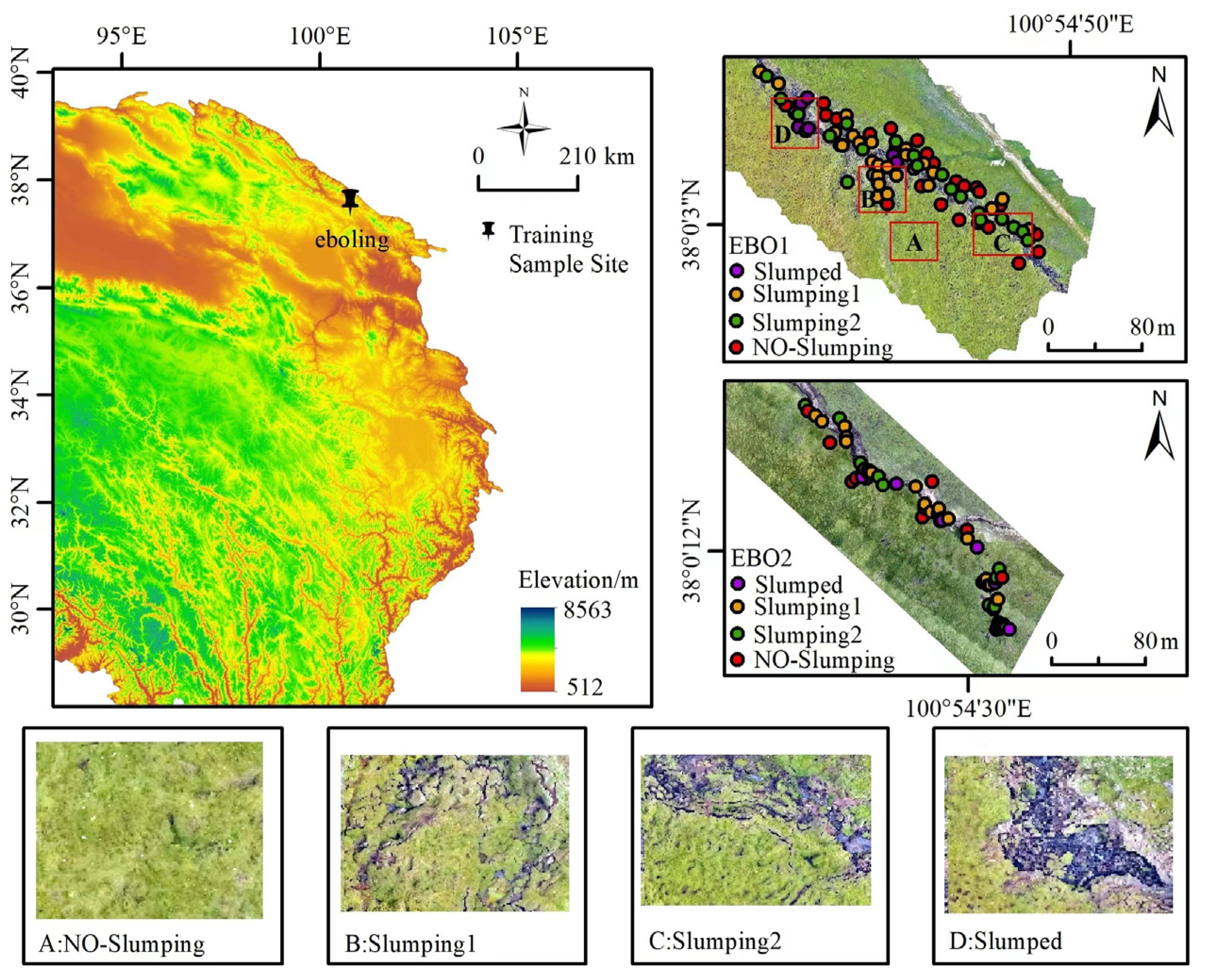
Figure 1. The location, soil sampling sites (used for training models) and landscape features in TGs on the Tibetan Plateau (Eboling: EBO1 and EBO2).
Remotesensing 15 01628 g001
Figure 2. The location, soil sampling sites (used for testing models) and landscape features in TGs on the Tibetan Plateau (MY: MenYuan; ML: MuLi; ZK: Ze Ku; TD: TongDe; BYKL: Bayankra).
Remotesensing 15 01628 g002
Figure 3. Prediction accuracy of SOC content in both the training set and the test dataset by using the selected 11 predictors.
Remotesensing 15 01628 g003
Figure 4. The relative importance of the factors in the optimal SVM model for predicting the SOC content (ST: soil temperature; VWC: soil volume water content; TPI: the topographic position index; OSAVI: Optimized Soil Adjusted Vegetation Index; NDRE: Normalized Difference Red Edge Index).
Remotesensing 15 01628 g004
Figure 5. SOC content prediction map and its corresponding uncertainty map of the TG at 5–30 cm depth interval.
Remotesensing 15 01628 g005
Figure 6. The predicted SOC content and all the 11 predictors in the four different landscapes within the TG in EBO1 based on the final SVM model (Predicted SOC: predicted soil organic carbon content; ST: soil temperature; OSAVI: The Optimized Soil Adjusted Vegetation Index; VWC: soil volume water content; NDRE: Normalized Difference Red Edge Index; TPI: Topographic Position Index).
Remotesensing 15 01628 g006
Table 1. Soil sample conditions in different TGs.
EBO1EBO2ZK1ZK2TDBYKLGC
Total836344444
NO-Slumping251011111
Slumping1271911111
Slumping221911111
Slumped102511111
Table 2. The 18 selected factors from 4 drivers.
NODriverPredictors
1TextureClay, Silt, Sand
2Other soil propertiesST, VWC, pH
3TopographyTPI, Roughness
4Multispectral dataRed, OSAVI, NDRE
ST: soil temperature; VWC: soil volume water content; TPI: Topographic Position Index; OSAVI: Optimized Soil Adjusted Vegetation Index; NDRE: Normalized Difference Red Edge Index.
Disclaimer/Publisher’s Note: The statements, opinions and data contained in all publications are solely those of the individual author(s) and contributor(s) and not of MDPI and/or the editor(s). MDPI and/or the editor(s) disclaim responsibility for any injury to people or property resulting from any ideas, methods, instructions or products referred to in the content.