Assessing Glacier Boundaries in the Ala-Archa Valley of Kyrgyzstan by Using Sentinel-1 SAR Dataset and High-Resolution UAV Imagery
Abstract
1. Introduction
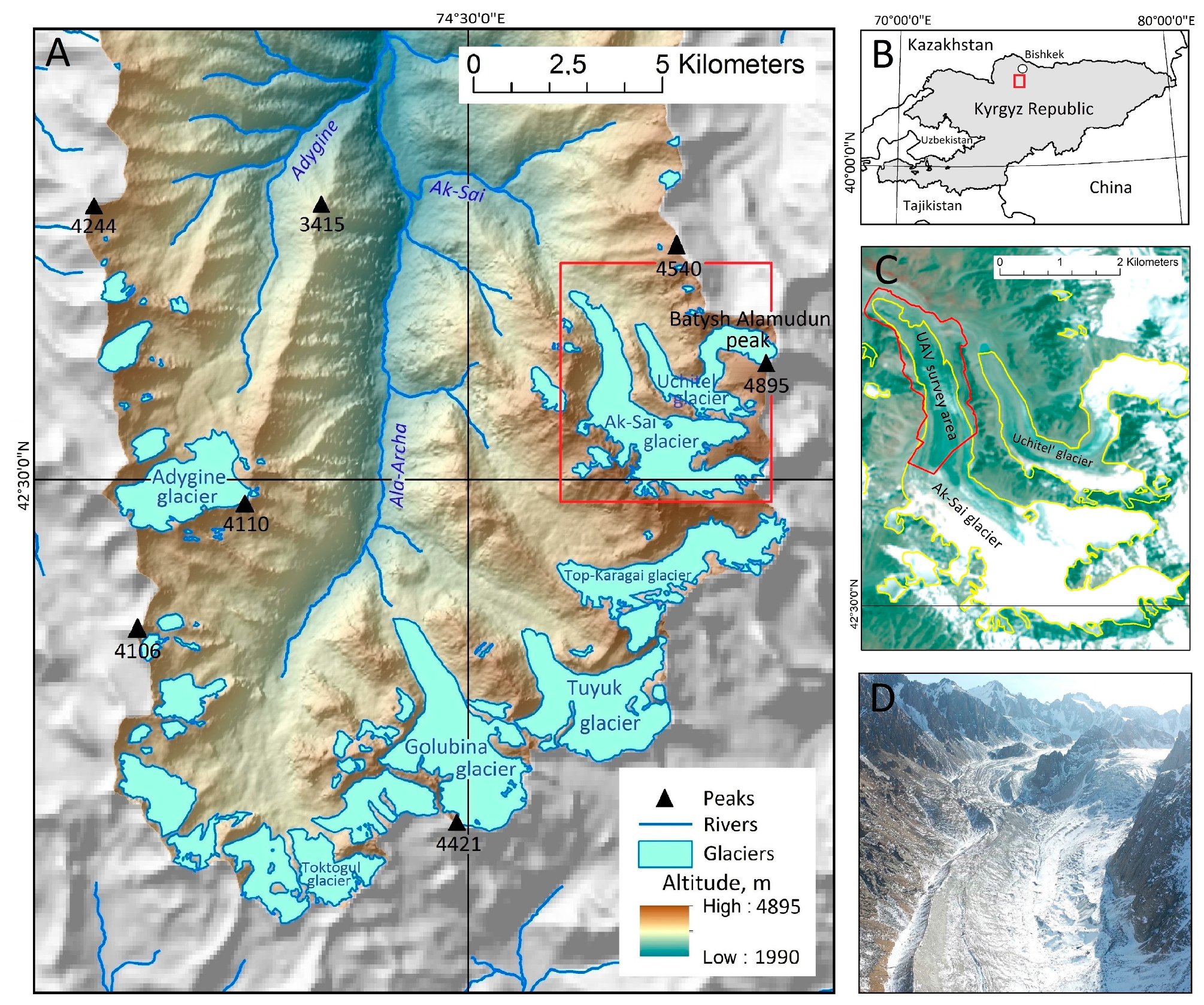
2. Study Site
3. Data and Methods
3.1. Data
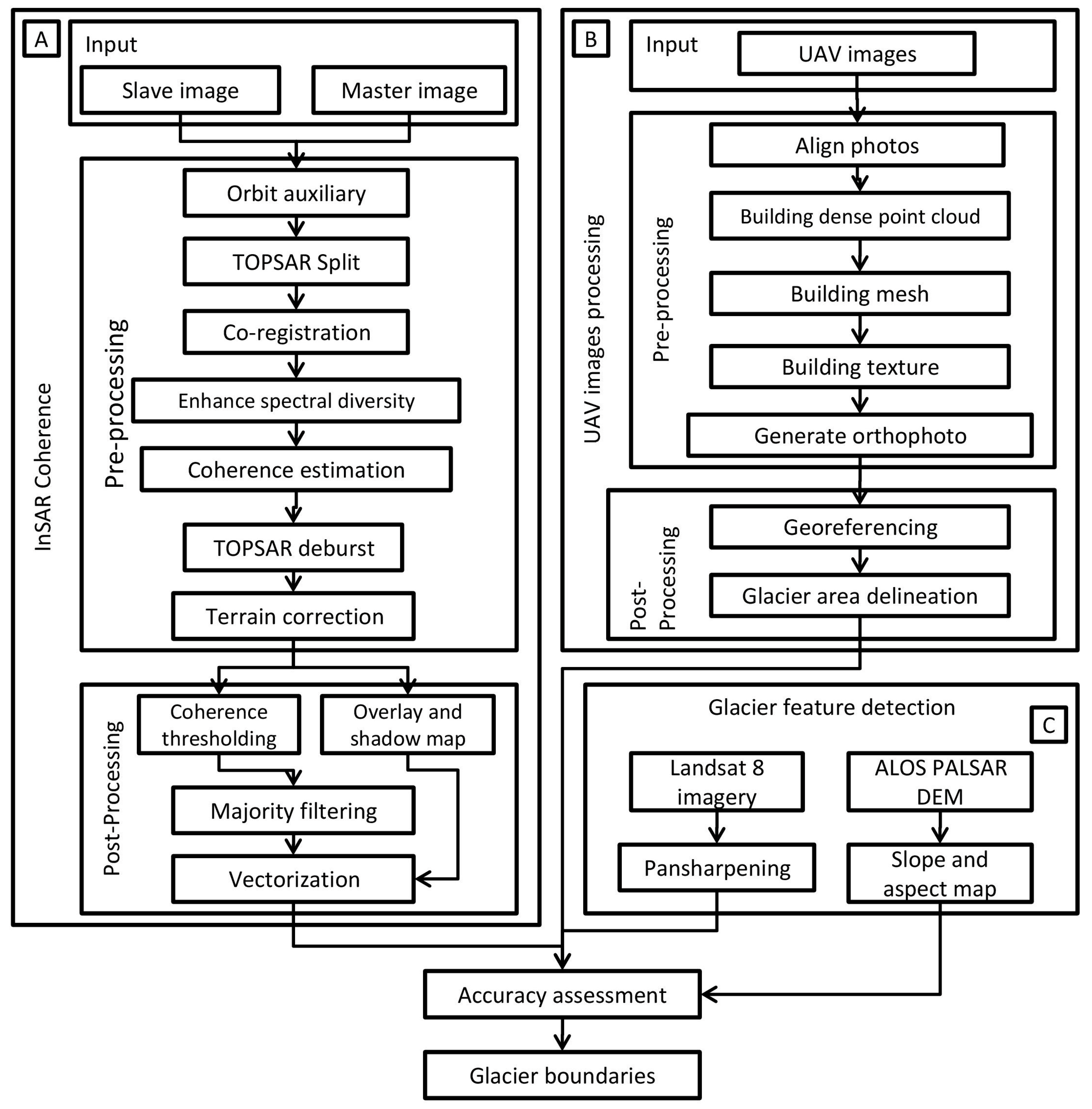
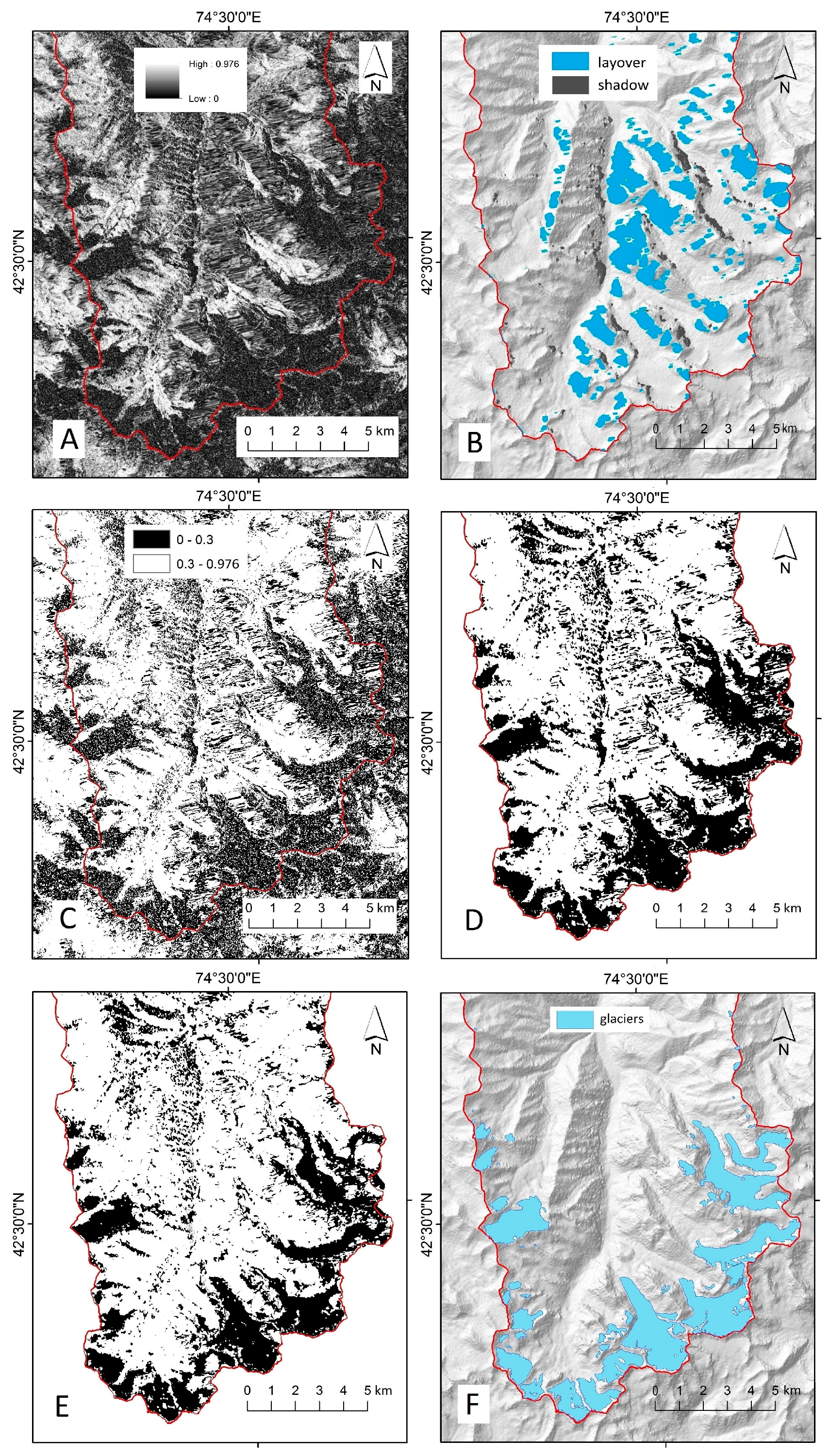
3.2. Methodology
3.3. Glacier Mapping by Using Orthogonal UAV Image
4. Results and Discussion
4.1. Glaciers Hypsometry and Morphology
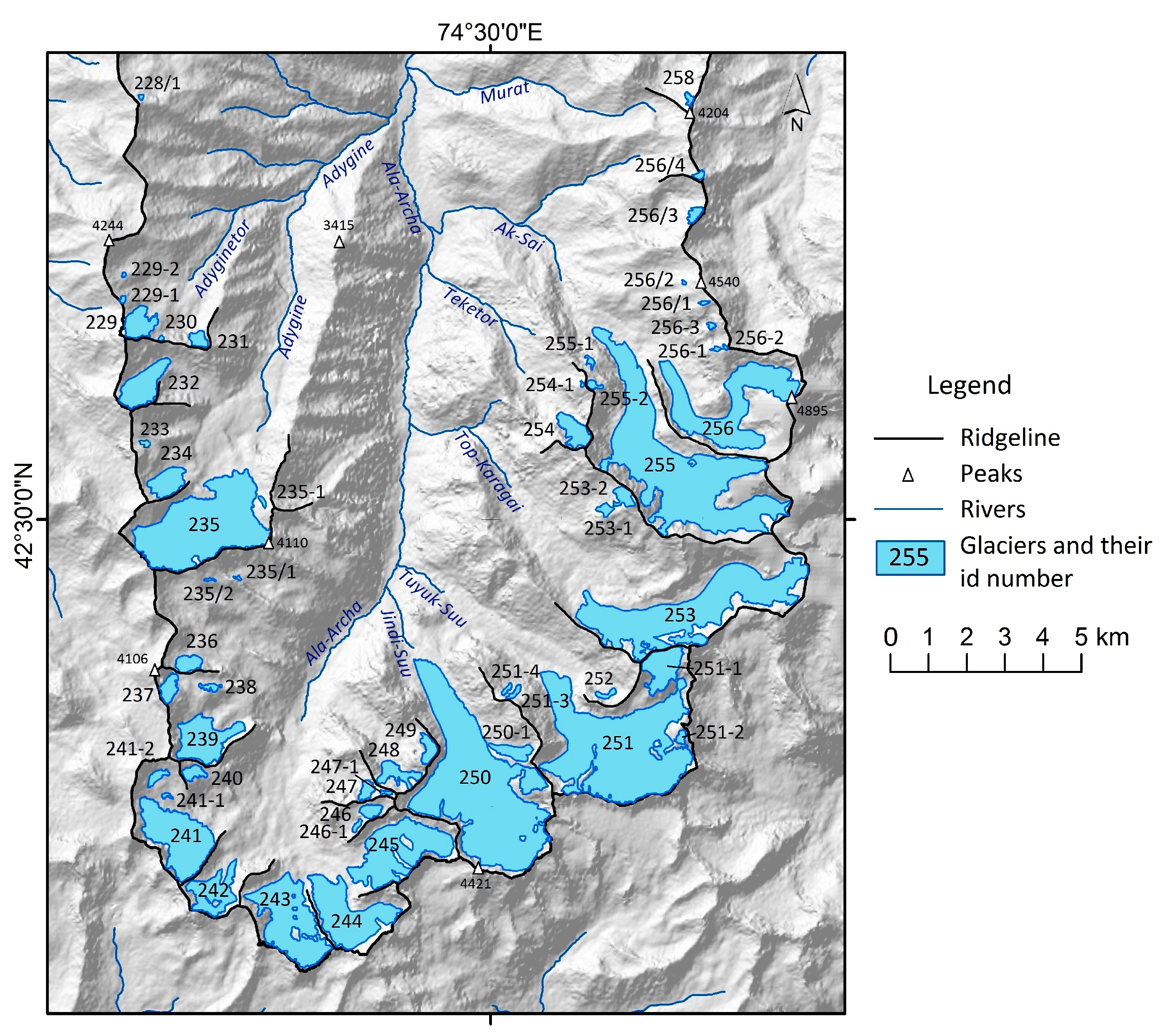
4.2. Updating the Inventory of Glaciers
5. Conclusions
Author Contributions
Funding
Data Availability Statement
Conflicts of Interest
References
- Maksimov, E.V.; Bajaeva, V.Y. Catalog of Glaciers of the USSR; Gidrometeoizdat: Leningrad, Russia, 1973; Volume 14, pp. 1–77. [Google Scholar]
- Maksimov, E.V.; Osmonov, A.O. Features of Modern Glaciations and Dynamics of Glaciers of the Kyrgyz Ala-Too; Ilim: Bishkek, Kyrgyzstan, 1995; pp. 41–42. [Google Scholar]
- Bolch, T. Glacier area and mass changes since 1964 in the Ala Archa Valley, Kyrgyz Ala-Too, northern Tien Shan. Led iSneg 2015, 129, 28–39. [Google Scholar] [CrossRef]
- Aizen, V.B.; Kuzmichenok, V.A.; Surazakov, A.B.; Aizen, E.M. Glacier Changes in the Central and Northern Tien Shan during the Last 140 Years Based on Surface and Remote-Sensing Data. Ann. Glaciol. 2006, 43, 202–213. [Google Scholar] [CrossRef]
- Aizen, V.B.; Aizen, E.M.; Kuzmichonok, V.A. Glaciers and hydrological changes in the Tien Shan: Simulation and prediction. Environ. Res. Lett. 2007, 2, 45019. [Google Scholar] [CrossRef]
- Azisov, E.; Hoelzle, M.; Vorogushyn, S.; Saks, T.; Usubaliev, R.; Esenamanuulu, M.; Barandun, M. Reconstructed Centennial Mass Balance Change for Golubin Glacier, Northern Tien Shan. Atmosphere 2022, 13, 954. [Google Scholar] [CrossRef]
- Zholdoshbekov, E.; Garg, V.; Thakur, P.K.; Duishonakunov, M.; Voda, M. Delineation of Radar Zones of Glaciers in The Ala-Archa Valley of Kyrgyz Republic. Geogr. Tech. 2021, 16, 100–110. [Google Scholar] [CrossRef]
- Yang, H.; Xu, G.Y.; Mao, H.X.; Wang, Y. Spatiotemporal Variation in Precipitation and Water Vapor Transport Over Central Asia in Winter and Summer Under Global Warming. Front. Earth Sci. 2020, 8, 297. [Google Scholar] [CrossRef]
- Atwood, D.K.; Meyer, F.J.; Arendt, A.A. Using L-band SAR coherence to delineate glacier extent. Can. J. Remote Sens. 2010, 36, 186–195. [Google Scholar] [CrossRef]
- Lippl, S.; Vijay, S.; Braun, M. Automatic delineation of debris-covered glaciers using InSAR coherence derived from X-, C- and L-band radar data: A case study of Yazgyl Glacier. J. Glaciol. 2018, 64, 811–821. [Google Scholar] [CrossRef]
- Bolch, T.; Kamp, U. Glacier Mapping in High Mountains Using DEMs, Landsat and ASTER Data. 2005. Available online: https://www.semanticscholar.org/paper/Glacier-mapping-in-high-mountains-using-DEMs%2C-and-Bolch-Kamp/123fcb9070bb27cce3b899bd53cbe787931bf25a (accessed on 28 January 2023).
- Shi, Y.; Liu, G.; Wang, X.; Liu, Q.; Zhang, R.; Jia, H. Assessing the Glacier Boundaries in the Qinghai-Tibetan Plateau of China by Multi-Temporal Coherence Estimation with Sentinel-1A InSAR. Remote Sens. 2019, 11, 392. [Google Scholar] [CrossRef]
- Moretto, S.; Bozzano, F.; Mazzanti, P. The Role of Satellite InSAR for Landslide Forecasting: Limitations and Openings. Remote Sens. 2021, 13, 3735. [Google Scholar] [CrossRef]
- Zhang, Y.; Liu, Y.; Jin, M.; Jing, Y.; Liu, Y.; Liu, Y.; Sun, W.; Wei, J.; Chen, Y. Monitoring Land Subsidence in Wuhan City (China) using the SBAS-InSAR Method with Radarsat-2 Imagery Data. Sensors 2019, 19, 743. [Google Scholar] [CrossRef]
- Kotlyakov, V.M.; Alekseev, V.R.; Volkov, N.V. Glyatsiologicheskiy Slovar; Kotlyakov, V.M., Ed.; Gidrometeoizdat: Leningrad, Russia, 1984; pp. 202–203. [Google Scholar]
- Cuffey, K.M.; Paterson, W.S. The Physics of Glaciers; Academic Press: Cambridge, MA, USA, 2010; pp. 286–307. [Google Scholar]
- Janowski, L.; Tylmann, K.; Trzcinska, K.; Rudowski, S.; Tegowski, J. Exploration of Glacial Landforms by Object-Based Image Analysis and Spectral Parameters of Digital Elevation Model. IEEE Trans. Geosci. Remote Sens. 2022, 60, 4502817. [Google Scholar] [CrossRef]
- Abermann, J.; Fischer, A.; Lambrecht, A.; Geist, T. On the potential of very high-resolution repeat DEMs in glacial and periglacial environments. Cryosphere 2010, 4, 53–65. [Google Scholar] [CrossRef]
- Shukla, A.; Arora, M.K.; Gupta., R.P. Synergistic approach for mapping debris-covered glaciers using optical–thermal remote sensing data with inputs from geomorphometric parameters. Remote Sens. Environ. 2010, 114, 1378–1387. [Google Scholar] [CrossRef]
- Finish Meteorological Institute. Available online: https://en.ilmatieteenlaitos.fi/press-release/1096339490URL (accessed on 24 October 2021).
- Umyrzakov, A.K. Atlas of the Kirgiz Soviet Socialist Republic; Natural Conditions and Resources; Publishing House GUGK: Moscow, Russia, 1987; Volume 1, p. 36. [Google Scholar]
- Kattel, D.B.; Mohanty, A.; Daiyrov, M.; Wang, W.; Mishra, M.; Kulenbekov, Z.; Dawadi, B. Evaluation of glacial lakes and catastrophic floods on the northern slopes of the Kyrgyz Range. Mount. Res. Dev. 2020, 40, 37–47. [Google Scholar] [CrossRef]
- National Statistic Committee of the Kyrgyz Republic. Demographic Yearbook of the Kyrgyz Republic. 2020. Available online: http://www.stat.kg/ru/publications/demograficheskij-ezhegodnik-kyrgyzskoj-respubliki/ (accessed on 21 January 2023).
- National Statistic Committee of the Kyrgyz Republic. Final Report About the Size of Cultivated Area Under the Hrvest of 2022. 2022. Available online: http://www.stat.kg/ru/publications/statisticheskij-byulleten-zaklyuchitelnyj-otchet-o-razmerah-ploshadi-poseva-selskohozyajstvennyh-kultur-v-razreze-oblastej-i-rajonov-kyrgyzskoj-respubliki-po-sostoyaniyu-na-1-iyunya-2013g/ (accessed on 21 January 2023).
- National Statistic Committee of the Kyrgyz Republic. The Environment in the Kyrgyz Republic: Statistical Compilation 2017–2021. 2022. Available online: http://www.stat.kg/media/publicationarchive/c210d76d-91e9-4e8e-a597-e49217759846.pdf (accessed on 21 January 2023).
- Dyurgerov, M.B.; Liu, C.; Xie, Z. Oledenenie Tian Shania (Tien Shan Glaciation); VINITI: Moscow, Russia, 1995; p. 57. [Google Scholar]
- Aizen, V. Glaciation and Its Evolution at Northern Tien Shan’s Peripheral Ranges. Ph.D. Thesis, Russian Academy of Science, Moscow, Russia, 1988. [Google Scholar]
- Fyffe, C.L.; Brock, B.W.; Kirkbride, M.P.; Mair, D.W.F.; Arnold, N.S.; Smiraglia, C.; Diolaiuti, G.; Diotri, F. Do debris-covered glaciers demonstrate distinctive hydrological behaviour compared to clean glaciers? J. Hydrol. 2019, 570, 584–597. [Google Scholar] [CrossRef]
- Ruiz, L.; Berthier, E.; Masiokas, M.; Pitte, P.; Villalba, R. First Surface Velocity Maps for Glaciers of Monte Tronador, North Patagonian Andes, Derived from Sequential Pléiades Satellite Images. J. Glaciol. 2015, 61, 908–922. [Google Scholar] [CrossRef]
- Guan, W.; Cao, B.; Pan, B.; Chen, R.; Shi, M.; Li, K.; Zhao, X.; Sun, X. Updated surge-type glacier inventory in the West Kunlun Mountains, Tibetan Plateau, and implications for glacier change. J. Geophys. Res. Earth Surf. 2022, 127, e2021JF006369. [Google Scholar] [CrossRef]
- NASA’s Alaska Satellite Facility (ASF) DAAC. Available online: https://search.asf.alaska.edu/ (accessed on 15 February 2022).
- The pyroSAR Developers. Available online: https://pyrosar.readthedocs.io/en/latest/general/OSV.html (accessed on 1 February 2023).
- Chandler, B.M.P.; Evans, D.J.A. Glacial Processes and Sediments. In Encyclopedia of Geology, 2nd ed.; Alderton, D., Elias, S., Eds.; Academic Press: Oxford, UK, 2021; pp. 830–856. [Google Scholar]
- Rocca, F.; Prati, C.; Guarnieri, A.M.; Ferretti, A. Sar Interferometry and its Applications. Surv. Geophys. 2000, 21, 159–176. [Google Scholar] [CrossRef]
- Tzouvaras, M.; Danezis, C.; Hadjimitsis, D.G. Small Scale Landslide Detection Using Sentinel-1 Interferometric SAR Coherence. Remote Sens. 2020, 12, 1560. [Google Scholar] [CrossRef]
- Closson, D.; Milisavlievic, N. InSAR Coherence and Intensity Changes Detection. In Mine Action–The Research Experience of the Royal Military Academy of Belgium; InTech: London, UK, 2017; Volume 23, pp. 156–176. [Google Scholar] [CrossRef]
- Woodhouse, I.H. Introduction to Microwave Remote Sensing; CRC Press: Boca Raton, FL, USA, 2006; pp. 36–37. [Google Scholar]
- Touzi, R.; Lopez, A.; Bruniquel, J.; Vachon, P.W. Coherence estimation for SAR imagery. IEEE Trans. Geosci. Remote. Sens. 1999, 37, 135–149. [Google Scholar] [CrossRef]
- Wang, Z.; Wang, Y.; Wang, B.; Xiang, M.; Wang, R.; Xu, W.; Song, C. Multi-Frequency Interferometric Coherence Characteristics Analysis of Typical Objects for Coherent Change Detection. Remote Sens. 2022, 14, 1689. [Google Scholar] [CrossRef]
- Friedl, B.; Hölbling, D. Using SAR Interferograms and Coherence Images for Object-Based Delineation of Unstable Slopes. In Proceedings of the FRINGE 2015 Workshop: Advances in the Science and Applications of SAR Interferometry and Sentinel-1InSAR Workshop, Frascati, Italy, 23–27 March 2015; European Space Agency: Frascati, Italy, 2015. [Google Scholar] [CrossRef]
- Shukla, A.; Gupta, R.P.; Arora, M.K. Delineation of debris-covered glacier boundaries using optical and thermal remote sensing data. Remote Sens. Lett. 2010, 1, 11–17. [Google Scholar] [CrossRef]
- USGS EarthExplorer. Available online: https://earthexplorer.usgs.gov/ (accessed on 20 February 2022).
- Voda, M.; Montes, Y.S. Descending mountain routes future: The North Yungas and Fagaras Geosystem’s comparative study. Geogr. Tech. 2018, 13, 152–166. [Google Scholar] [CrossRef]
- Rahaman, K.R.; Hassan, Q.K.; Ahmed, M.R. Pan-Sharpening of Landsat-8 Images and Its Application in Calculating Vegetation Greenness and Canopy Water Contents. ISPRS Int. J. Geo-Inf. 2017, 6, 168. [Google Scholar] [CrossRef]
- Gupta, S.K.; Negru, R.; Voda, M. The Indian Himalaya’s unique attributes: Hemkund Sahib and The Valley of Flowers. Geogr. Tech. 2018, 13, 62–73. [Google Scholar] [CrossRef]
- Zhang, J. Multi-source remote sensing data fusion: Status and trends. Int. J. Image Data Fusion 2010, 1, 5–24. [Google Scholar] [CrossRef]
- Ganyushkin, D.; Chistyakov, K.; Derkach, E.; Bantcev, D.; Kunaeva, E.; Terekhov, A.; Rasputina, V. Glacier Recession in the Altai Mountains after the LIA Maximum. Remote Sens. 2022, 14, 1508. [Google Scholar] [CrossRef]
- Andreassen, L.M.; Nordli, Ø.; Rasmussen, A.; Melvold, K.; Nordli, Ø. Langfjordjøkelen, a Rapidly Shrinking Glacier in Northern Norway. J. Glaciol. 2012, 58, 581–593. [Google Scholar] [CrossRef]
- Leigh, J.R.; Stokes, C.R.; Carr, R.J.; Evans, I.S.; Andreassen, L.M.; Evans, D.J.A. Identifying and Mapping Very Small (<0.5 km2) Mountain Glaciers on Coarse to High-Resolution Imagery. J. Glaciol. 2019, 65, 873–888. [Google Scholar] [CrossRef]
- Fischer, M.; Huss, M.; Barboux, C.; Hoelzle, M. The New Swiss Glacier Inventory SGI2010: Relevance of Using High-Resolution Source Data in Areas Dominated by Very Small Glaciers. Arct. Antarct. Alp. Res. 2014, 46, 933–945. [Google Scholar] [CrossRef]
- López, P.; Chevallier, P.; Favier, V.; Pouyaud, B.; Ordenes, F.; Oerlemans, J. A regional view of fluctuations in glacier length in southern South America. Glob. Planet. Change 2010, 71, 85–108. [Google Scholar] [CrossRef]
- Machguth, H.; Huss, M. The length of the world’s glaciers–a new approach for the global calculation of center lines. Cryosphere 2014, 8, 1741–1755. [Google Scholar] [CrossRef]
- Narama, C.; Kääb, A.; Duishonakunov, M.; Abdrakhmatov, K. Spatial variability of recent glacier area changes in the Tien Shan Mountains, Central Asia, using Corona (~1970), Landsat (~2000), and ALOS (~2007) satellite data. Glob. Planet. Change 2010, 71, 42–54. [Google Scholar] [CrossRef]
- Aizen, V.; Aizen, E. Hydrological cycles on the north and south peripheries of mountain glacial basins of central Asia. Hydrol. Process. 1997, 11, 451–469. [Google Scholar] [CrossRef]


| Mission | Product Type | Beam Mode | Orbit | Orbit Type | Polarization | Acquisition Date |
|---|---|---|---|---|---|---|
| S1A | SLC | IW | 39299 | Ascending | VV | 19.08.2021 |
| S1A | SLC | IW | 39474 | Ascending | VV | 31.08.2021 |
| Size Class (km2) | Number | Total Area | Mean Area (km2) | ||
|---|---|---|---|---|---|
| (n) | (%) | (km2) | (%) | ||
| <0.1 | 33 | 58.9 | 1.06 | 3.4 | 0.03 |
| 0.1–0.2 | 5 | 8.9 | 0.66 | 2.1 | 0.13 |
| 0.2–0.5 | 6 | 10.7 | 1.97 | 6.3 | 0.33 |
| 0.5–1.0 | 2 | 3.6 | 1.22 | 3.9 | 0.61 |
| 1.0–2.0 | 5 | 8.9 | 7.02 | 22.3 | 1.40 |
| 2.0–5.0 | 4 | 7.1 | 14.38 | 45.7 | 3.40 |
| >5.0 | 1 | 1.8 | 5.14 | 16.3 | 5.14 |
| Total | 56 | 100 | 31.45 | 100 | 0.49 |
| Glacier Types | Glacier Number | Glacier Area | ||
|---|---|---|---|---|
| Count | % | km2 | % | |
| Hanging | 21 | 37.5 | 0.52 | 1.65 |
| Corrie | 15 | 26.8 | 1.24 | 3.94 |
| Valley | 8 | 14.3 | 19.92 | 63.33 |
| Corrie–valley | 4 | 7.1 | 1.13 | 3.59 |
| Slope glacier | 3 | 5.6 | 0.57 | 1.81 |
| Hanging–valley | 2 | 3.6 | 0.96 | 3.05 |
| Kettle glacier | 2 | 3.6 | 4.08 | 12.97 |
| Asymmetrical–valley | 1 | 1.8 | 3.05 | 9.70 |
| All | 56 | 100 | 31.45 | 100 |
| ID | Glacier Numeration (ID Code) | Glacier Name | Centroid Coordinates (WGS 1984 Datum) | River Catchment | Glacier Type | Mean Aspect | Area, km2 | Length, m | Altitude of Lowest Point, m.a.s.l. | Altitude of Highest Point, m.a.s.l. |
|---|---|---|---|---|---|---|---|---|---|---|
| 1 | 228/1 | 42°34′22.8″N 74°24′57.6″E | Kashkasuu | Hanging | N | 0.007 | 117 | 3930 | 4000 | |
| 2 | 229 | Adyginetor | 42°32′02.4″N 74°24′57.6″E | Adyginetor | Corrie–valley | NE | 0.257 | 703 | 3800 | 4340 |
| 3 | 229-1 | 42°32′16.8″N 74°24′46.8″E | Adyginetor | Hanging | NE | 0.014 | 185 | 3995 | 4090 | |
| 4 | 229-2 | 42°32′34.8″N 74°24′50.4″E | Adyginetor | Hanging | N | 0.006 | 154 | 3900 | 3950 | |
| 5 | 230 | 42°31′55.2″N 74°25′19.2″E | Adyginetor | Hanging | N | 0.010 | 130 | 3930 | 4015 | |
| 6 | 231 | 42°31′51.6″N 74°25′51.6″E | Adyginetor | Corrie | N | 0.078 | 350 | 3765 | 4010 | |
| 7 | 232 | 42°31′22.8″N 74°25′04.8″E | Adygine | Corrie–valley | N | 0.499 | 1230 | 3770 | 4260 | |
| 8 | 233 | 42°30′46.8″N 74°25′04.8″E | Adygine | Corrie | NE | 0.019 | 190 | 3920 | 4020 | |
| 9 | 234 | 42°30′21.6″N 74°25′26.4″E | Adygine | Corrie | N | 0.289 | 900 | 3675 | 4035 | |
| 10 | 235 | Adygene | 42°29′56.4″N 74°25′58.8″E | Adygine | Kettle glacier | N | 2.846 | 2820 | 3600 | 4150 |
| 11 | 235-1 | 42°30′10.8″N 74°26′49.2″E | Adygine | Hanging | NW | 0.017 | 290 | 3750 | 3950 | |
| 12 | 235/1 | 42°29′24.0″N 74°26′24.0″E | Ala-Archa | Corrie | NE | 0.008 | 167 | 3770 | 3890 | |
| 13 | 235/2 | 42°29′24.0″N 74°26′02.4″E | Ala-Archa | Corrie | SE | 0.012 | 300 | 3890 | 3975 | |
| 14 | 236 | 42°28′30.0″N 74°25′44.4″E | Ala-Archa | Corrie | N | 0.133 | 580 | 3680 | 3820 | |
| 15 | 237 | 42°28′15.6″N 74°25′26.4″E | Ala-Archa | Corrie | N | 0.148 | 680 | 3775 | 4000 | |
| 16 | 238 | 42°28′15.6″N 74°25′58.8″E | Ala-Archa | Hanging | N | 0.041 | 125 | 3730 | 3815 | |
| 17 | 239 | 42°27′39.6″N 74°25′58.8″E | Ala-Archa | Hanging–valley | NW | 0.701 | 1550 | 3500 | 3945 | |
| 18 | 240 | 42°27′21.6″N 74°25′48.0″E | Ala-Archa | Corrie | E | 0.093 | 510 | 3730 | 3915 | |
| 19 | 241 | Mal AA Zap | 42°26′42.0″N 74°25′33.6″E | Ala-Archa | Kettle glacier | NE | 1.231 | 1600 | 3590 | 3900 |
| 20 | 241-1 | 42°27′07.2″N 74°25′22.8″E | Ala-Archa | Slope glacier | NE | 0.015 | 220 | 3710 | 3755 | |
| 21 | 241-2 | 42°27′18.0″N 74°25′19.2″E | Ala-Archa | Corrie | SE | 0.065 | 300 | 3780 | 3860 | |
| 22 | 242 | Mal AA Vost | 42°26′13.2″N 74°26′13.2″E | Ala-Archa | Valley | N | 0.516 | 1940 | 3510 | 4040 |
| 23 | 243 | Bol AA Zap | 42°25′48.0″N 74°27′07.2″E | Ala-Archa | Valley | N | 1.413 | 2130 | 3495 | 3950 |
| 24 | 244 | Toktogul | 42°25′55.2″N 74°28′01.2″E | Ala-Archa | Valley | NW | 1.200 | 2570 | 3470 | 4115 |
| 25 | 245 | Manas | 42°26′31.2″N 74°28′40.8″E | Ala-Archa | Valley | NW | 1.377 | 2880 | 3490 | 4250 |
| 26 | 246 | 42°26′56.4″N 74°28′19.2″E | Ala-Archa | Corrie | W | 0.087 | 570 | 3940 | 4050 | |
| 27 | 246-1 | 42°26′49.2″N 74°28′04.8″E | Ala-Archa | Corrie | W | 0.026 | 240 | 3800 | 3940 | |
| 28 | 247 | 42°27′10.8″N 74°28′12.0″E | Ala-Archa | Corrie | NW | 0.080 | 640 | 3640 | 4010 | |
| 29 | 247-1 | 42°27′07.2″N 74°28′30.0″E | Ala-Archa | Hanging | NW | 0.019 | 180 | 3980 | 4160 | |
| 30 | 248 | 42°27′21.6″N 74°28′40.8″E | Ala-Archa | Corrie–valley | NW | 0.206 | 900 | 3565 | 4000 | |
| 31 | 249 | 42°27′36.0″N 74°29′06.0″E | Ala-Archa | Corrie | N | 0.118 | 680 | 3720 | 4010 | |
| 32 | 250 | Golubina | 42°27′10.8″N 74°29′52.8″E | Jindi-Suu | Valley | N | 5.138 | 4660 | 3340 | 4420 |
| 33 | 250-1 | 42°27′36.0″N 74°30′18.0″E | Jindi-Suu | Corrie–valley | NW | 0.163 | 860 | 3620 | 4060 | |
| 34 | 251 | Tuyuk | 42°27′36.0″N 74°31′48.0″E | Tuyuk-Suu | Valley | NW | 4.127 | 2810 * (3510 **) | 3390 | 4180 |
| 35 | 251-1 | 42°28′26.4″N 74°32′27.6″E | Tuyuk-Suu | Slope glacier | S | 0.490 | 1240 | 4020 | 4440 | |
| 36 | 251-2 | 42°27′43.2″N 74°32′42.0″E | Tuyuk-Suu | Slope glacier | SW | 0.060 | 310 | 4110 | 4230 | |
| 37 | 251-3 | 42°28′12.0″N 74°30′14.4″E | Tuyuk-Suu | Hanging | NE | 0.016 | 350 | 3800 | 4100 | |
| 38 | 251-4 | 42°28′12.0″N 74°30′10.8″E | Tuyuk-Suu | Hanging | N | 0.011 | 290 | 3810 | 4040 | |
| 39 | 252 | 42°28′12.0″N 74°30′37.2″E | Tuyuk-Suu | Corrie | N | 0.035 | 30 | 3645 | 3835 | |
| 40 | 253 | Top-Karagai | 42°29′06.0″N 74°32′52.8″E | Top-Karagai | Asymmetrical–valley | N | 3.052 | 4710 | 3700 | 4500 |
| 41 | 253-1 | 42°30′07.2″N 74°31′37.2″E | Top-Karagai | Corrie | SW | 0.052 | 350 | 4035 | 4300 | |
| 42 | 253-2 | 42°30′14.4″N 74°31′51.6″E | Top-Karagai | Hanging | NW | 0.119 | 560 | 4245 | 4530 | |
| 43 | 254 | Teketor | 42°30′57.6″N 74°31′08.4″E | Teketor | Hanging–valley | N | 0.250 | 1090 | 3690 | 4410 |
| 44 | 254-1 | 42°31′26.4″N 74°31′19.2″E | Teketor | Hanging | N | 0.006 | 130 | 4090 | 4200 | |
| 45 | 255 | Ak-Sai | 42°30′36.0″N 74°32′42.0″E | Ak-Sai | Valley | NW | 4.357 | 6515 | 3260 | 4565 |
| 46 | 255-1 | 42°31′40.8″N 74°31′26.4″E | Ak-Sai | Hanging | NE | 0.022 | 315 | 3660 | 3935 | |
| 47 | 255-2 | 42°31′22.8″N 74°31′26.4″E | Ak-Sai | Hanging | NE | 0.032 | 260 | 4120 | 4230 | |
| 48 | 256 | Uchitel’ | 42°31′12.0″N 74°33′25.2″E | Ak-Sai | Valley | NW | 1.796 | 4565 | 3600 | 4720 |
| 49 | 256-1 | 42°31′48.0″N 74°33′10.8″E | Ak-Sai | Hanging | NW | 0.011 | 150 | 4270 | 4380 | |
| 50 | 256-2 | 42°31′48.0″N 74°33′18.0″E | Ak-Sai | Hanging | NW | 0.006 | 120 | 4340 | 4420 | |
| 51 | 256-3 | 42°32′02.4″N 74°33′07.2″E | Ak-Sai | Hanging | NW | 0.015 | 230 | 4160 | 4350 | |
| 52 | 256/1 | 42°32′16.8″N 74°33′00.0″E | Ak-Sai | Hanging | SW | 0.011 | 237 | 4270 | 4410 | |
| 53 | 256/2 | 42°32′27.6″N 74°32′45.6″E | Ak-Sai | Hanging | NW | 0.005 | 113 | 4090 | 4161 | |
| 54 | 256/3 | 42°33′10.8″N 74°32′52.8″E | Sharkyratma | Hanging | NW | 0.080 | 304 | 3940 | 4164 | |
| 55 | 256/4 | Murat | 42°33′36.0″N 74°32′56.4″E | Murat-Sai | Hanging | NW | 0.027 | 200 | 4120 | 4196 |
| 56 | 258 | Kashka-Suu | 42°34′25.0″N 74°32′49.8″E | Kashka-Suu | Hanging | N | 0.040 | 308 | 3805 | 4005 |
| Glacier | Glacier Area, km2 | ||
|---|---|---|---|
| 1964 | 1999 | 2021 | |
| Uchitel | 2.2 | 2.0 | 1.796 |
| Adygine | 3.5 | 3.0 | 2.846 |
| Top-Karagai | 3.7 | 3.3 | 3.052 |
| Tuyuk | 5.2 | 5.0 | 4.127 |
| Ak-Sai | 4.8 | 4.5 | 4.357 |
| Golubina | 5.6 | 5.42 | 5.138 |
| All | 39.2 | 34.5 | 31.45 |
Disclaimer/Publisher’s Note: The statements, opinions and data contained in all publications are solely those of the individual author(s) and contributor(s) and not of MDPI and/or the editor(s). MDPI and/or the editor(s) disclaim responsibility for any injury to people or property resulting from any ideas, methods, instructions or products referred to in the content. |
© 2023 by the authors. Licensee MDPI, Basel, Switzerland. This article is an open access article distributed under the terms and conditions of the Creative Commons Attribution (CC BY) license (https://creativecommons.org/licenses/by/4.0/).
Share and Cite
Zholdoshbekov, E.; Duishonakunov, M.; Du, Q.; Voda, M. Assessing Glacier Boundaries in the Ala-Archa Valley of Kyrgyzstan by Using Sentinel-1 SAR Dataset and High-Resolution UAV Imagery. Remote Sens. 2023, 15, 1131. https://doi.org/10.3390/rs15041131
Zholdoshbekov E, Duishonakunov M, Du Q, Voda M. Assessing Glacier Boundaries in the Ala-Archa Valley of Kyrgyzstan by Using Sentinel-1 SAR Dataset and High-Resolution UAV Imagery. Remote Sensing. 2023; 15(4):1131. https://doi.org/10.3390/rs15041131
Chicago/Turabian StyleZholdoshbekov, Emilbek, Murataly Duishonakunov, Qingyun Du, and Mihai Voda. 2023. "Assessing Glacier Boundaries in the Ala-Archa Valley of Kyrgyzstan by Using Sentinel-1 SAR Dataset and High-Resolution UAV Imagery" Remote Sensing 15, no. 4: 1131. https://doi.org/10.3390/rs15041131
APA StyleZholdoshbekov, E., Duishonakunov, M., Du, Q., & Voda, M. (2023). Assessing Glacier Boundaries in the Ala-Archa Valley of Kyrgyzstan by Using Sentinel-1 SAR Dataset and High-Resolution UAV Imagery. Remote Sensing, 15(4), 1131. https://doi.org/10.3390/rs15041131


