Hydrological Response Assessment of Land Cover Change in a Peruvian Amazonian Basin Impacted by Deforestation Using the SWAT Model
Abstract
:1. Introduction
2. Materials and Methods
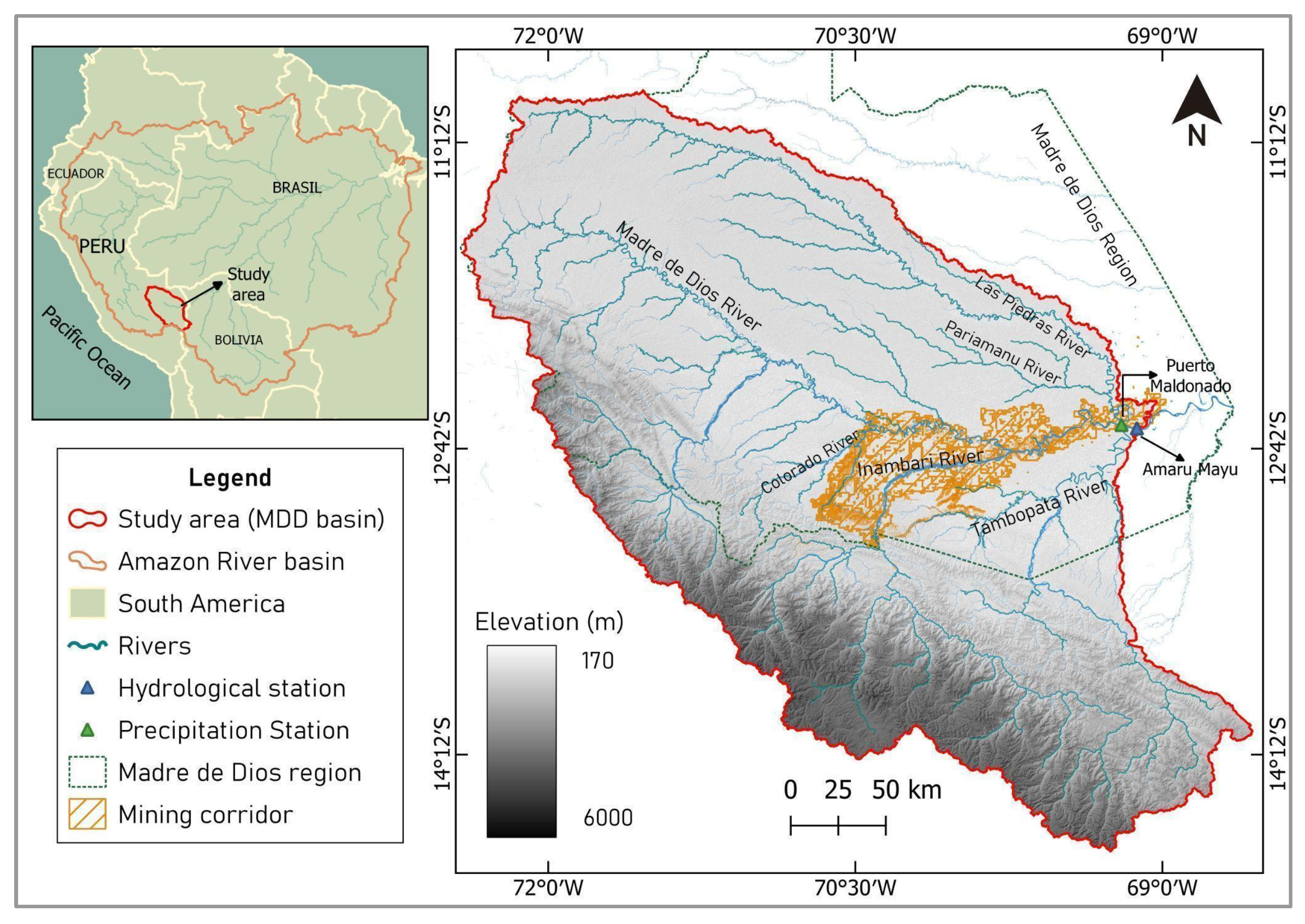
2.1. Study Area
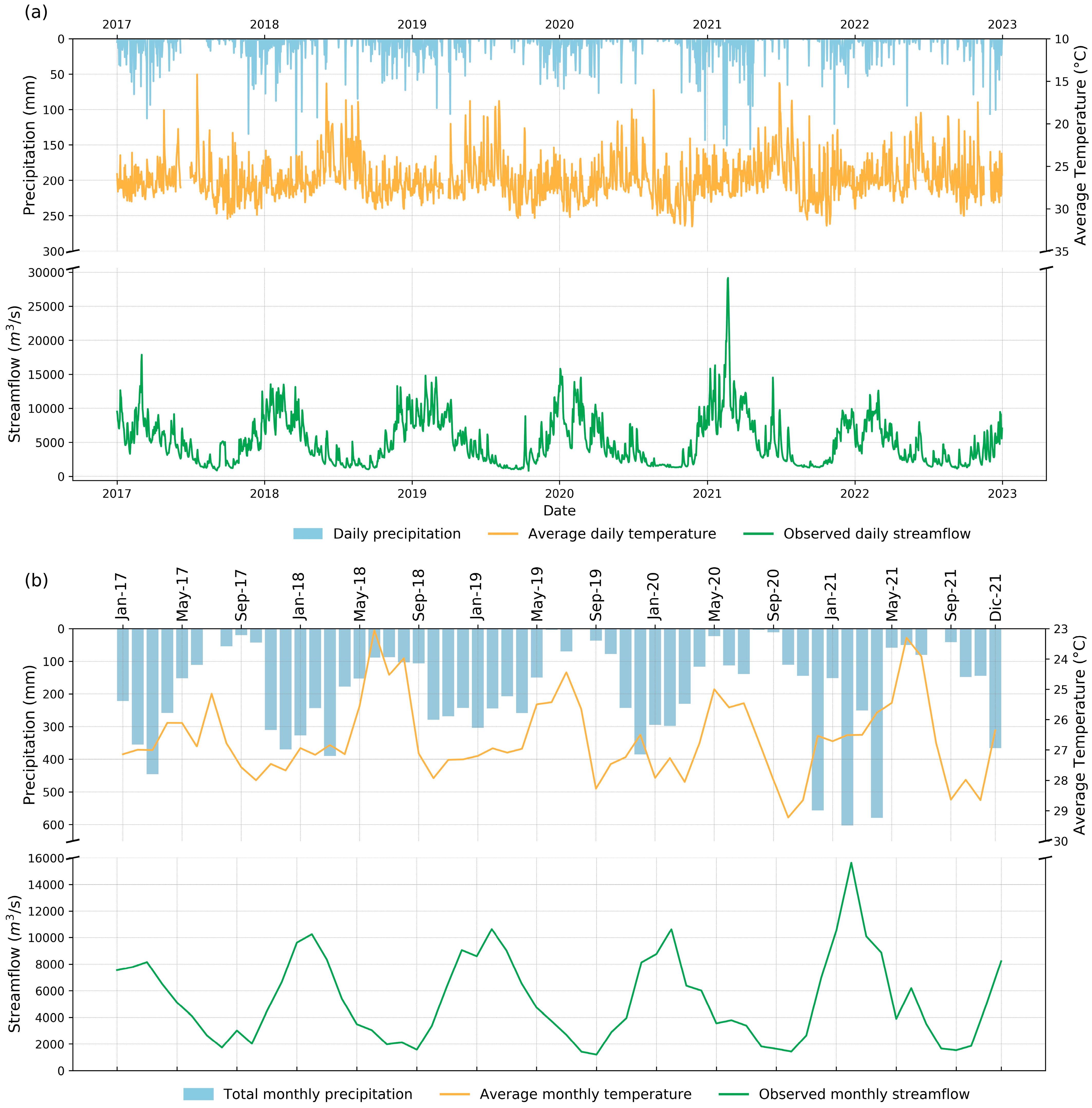
2.2. Climate Data
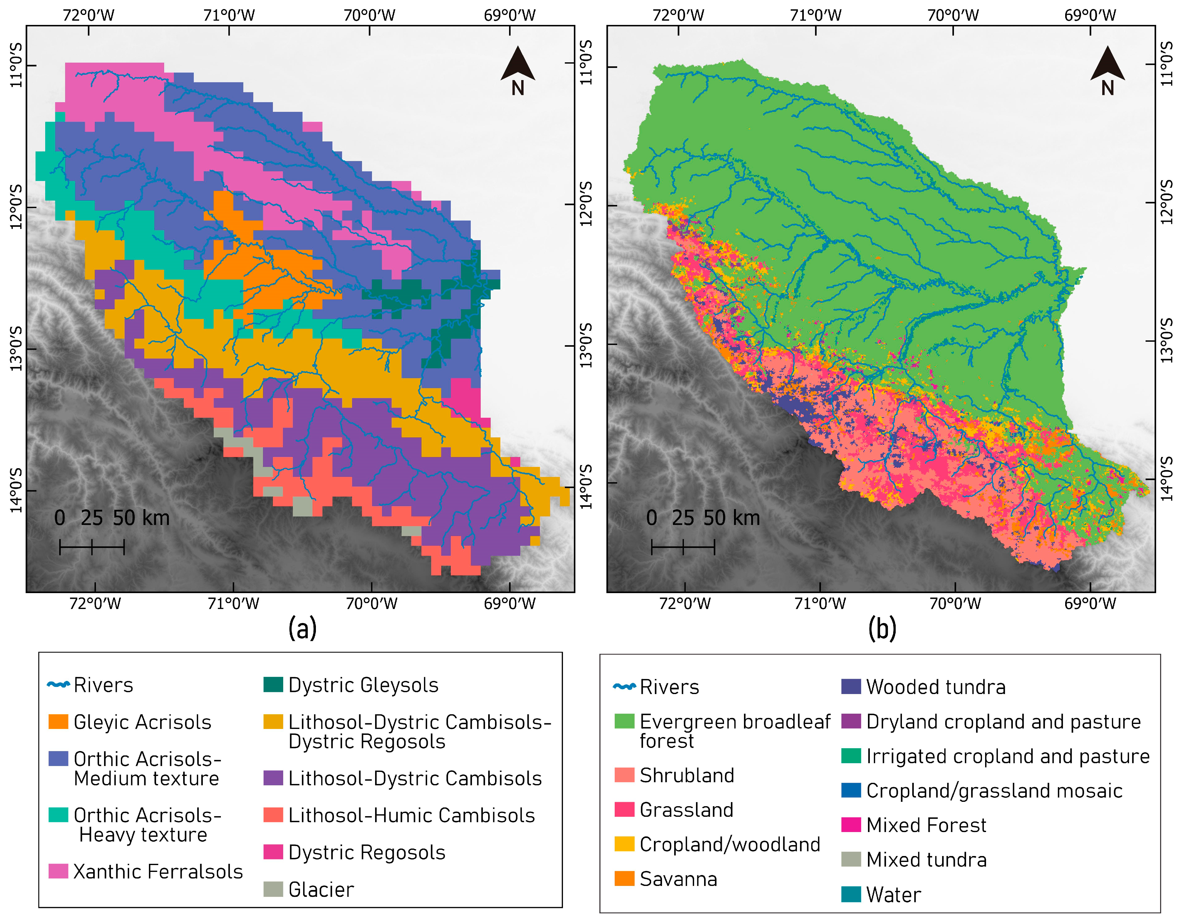
2.3. Topography, Soil, and Land Use Data
2.4. SWAT Model
2.4.1. Model Setup
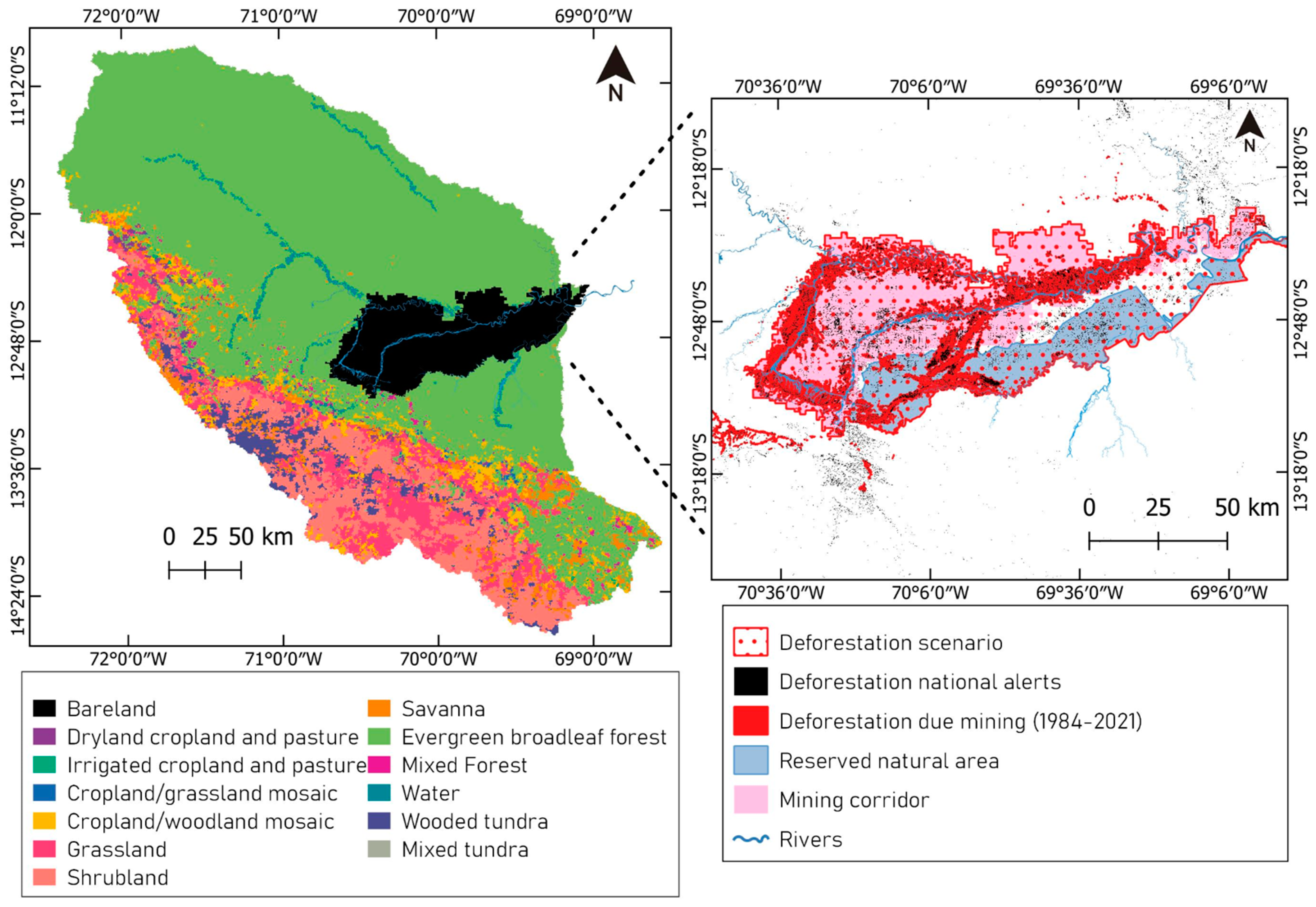
2.4.2. Deforestation Scenario
3. Results
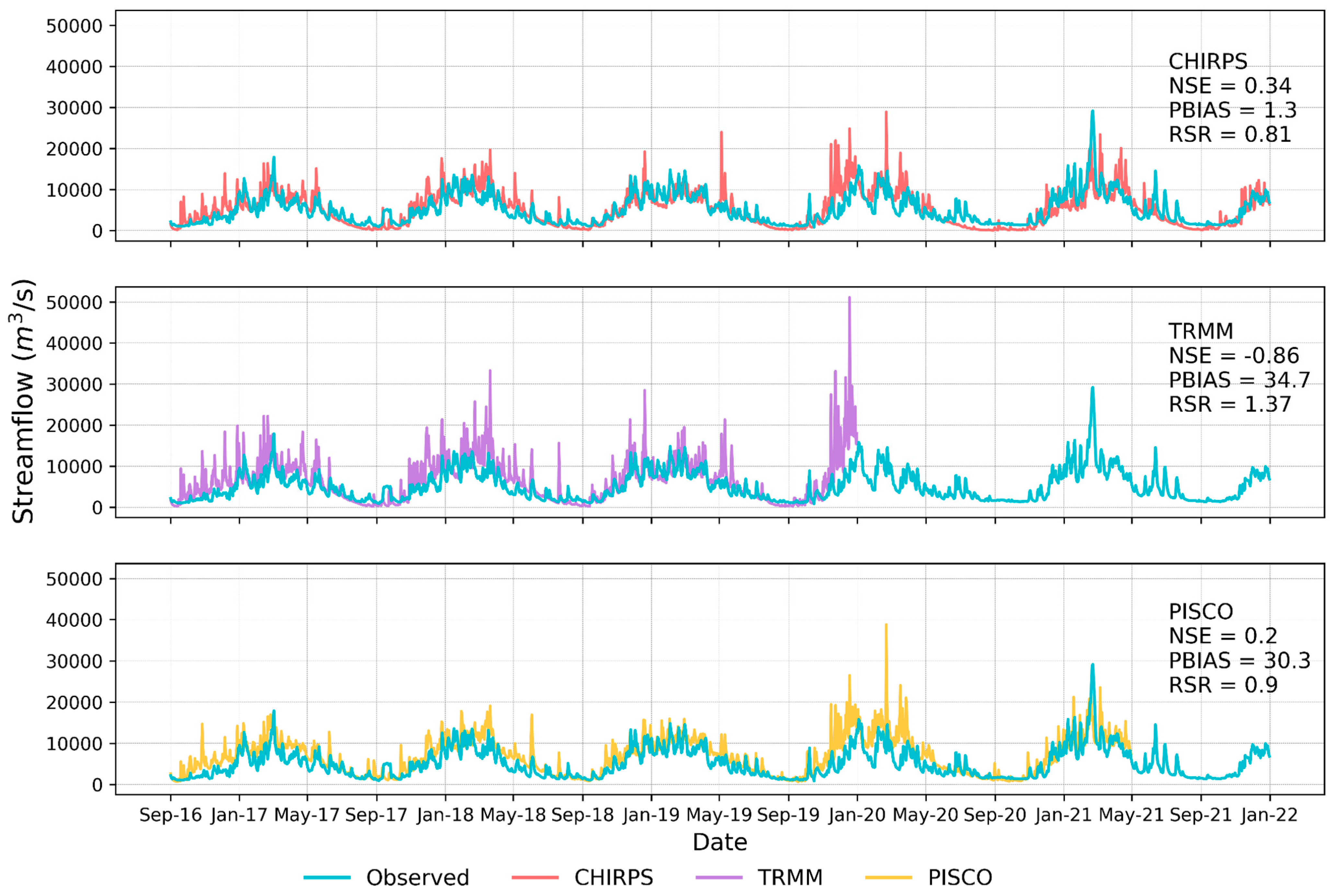
3.1. Correlation between Streamflows Generated by CHIRPS, TRMM, and PISCO Precipitation Datasets and In Situ Data
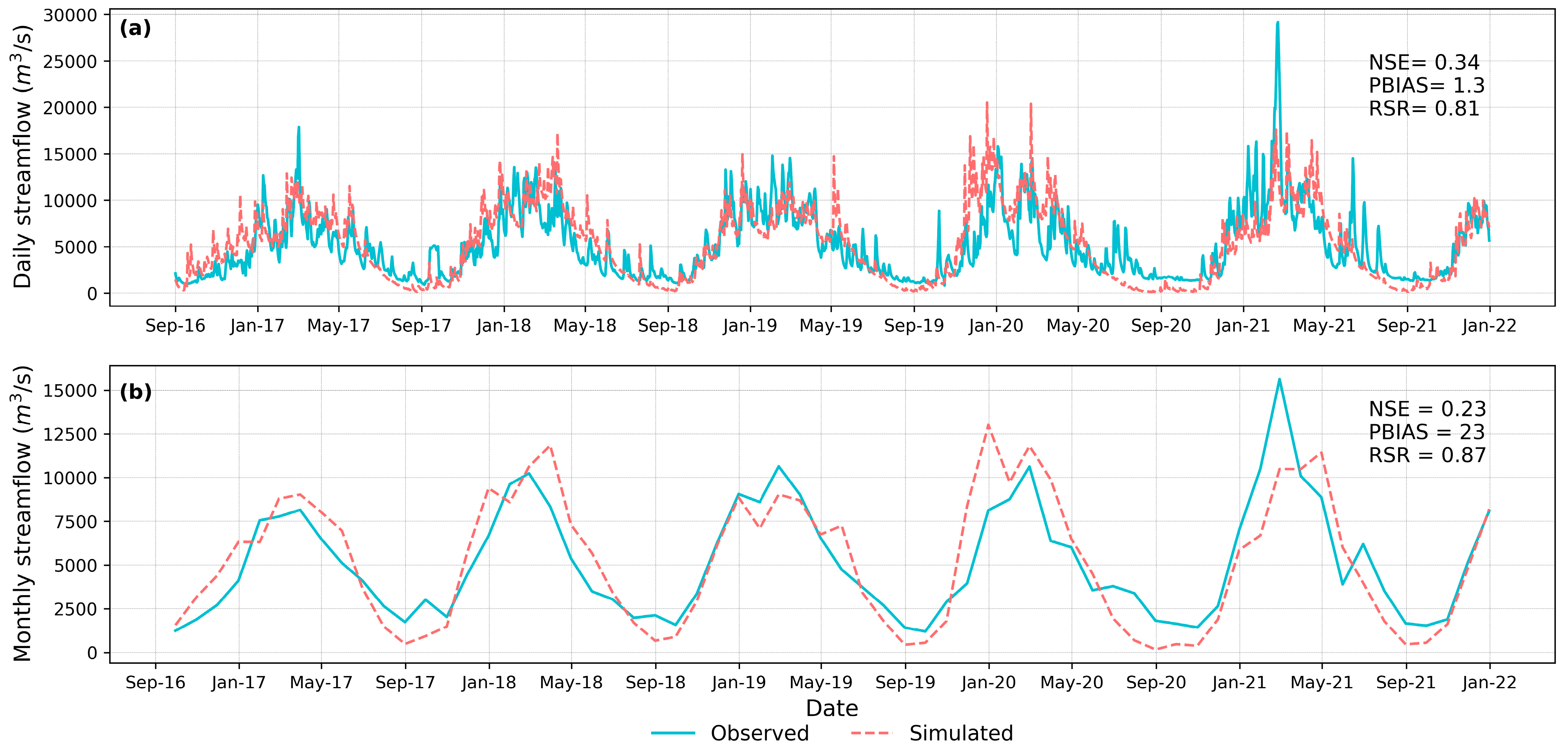
3.2. Model Performance, Calibration, and Uncertainty Analysis
3.3. Hydrological Basin Response Corresponding to the Deforestation Scenario Simulation
3.3.1. Average Monthly Means
3.3.2. Average Annual Means
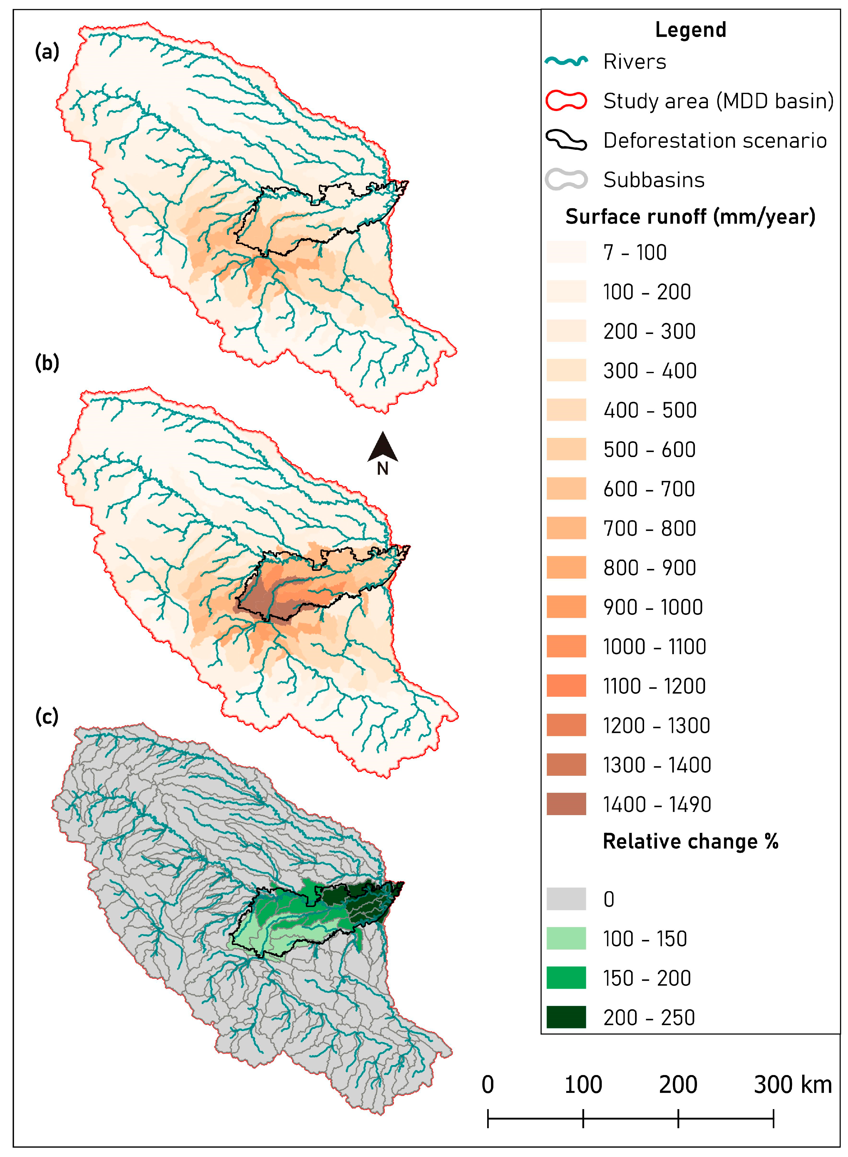
3.3.3. Average Annual Means at Subbasin Scale
4. Discussion
5. Conclusions
Author Contributions
Funding
Data Availability Statement
Acknowledgments
Conflicts of Interest
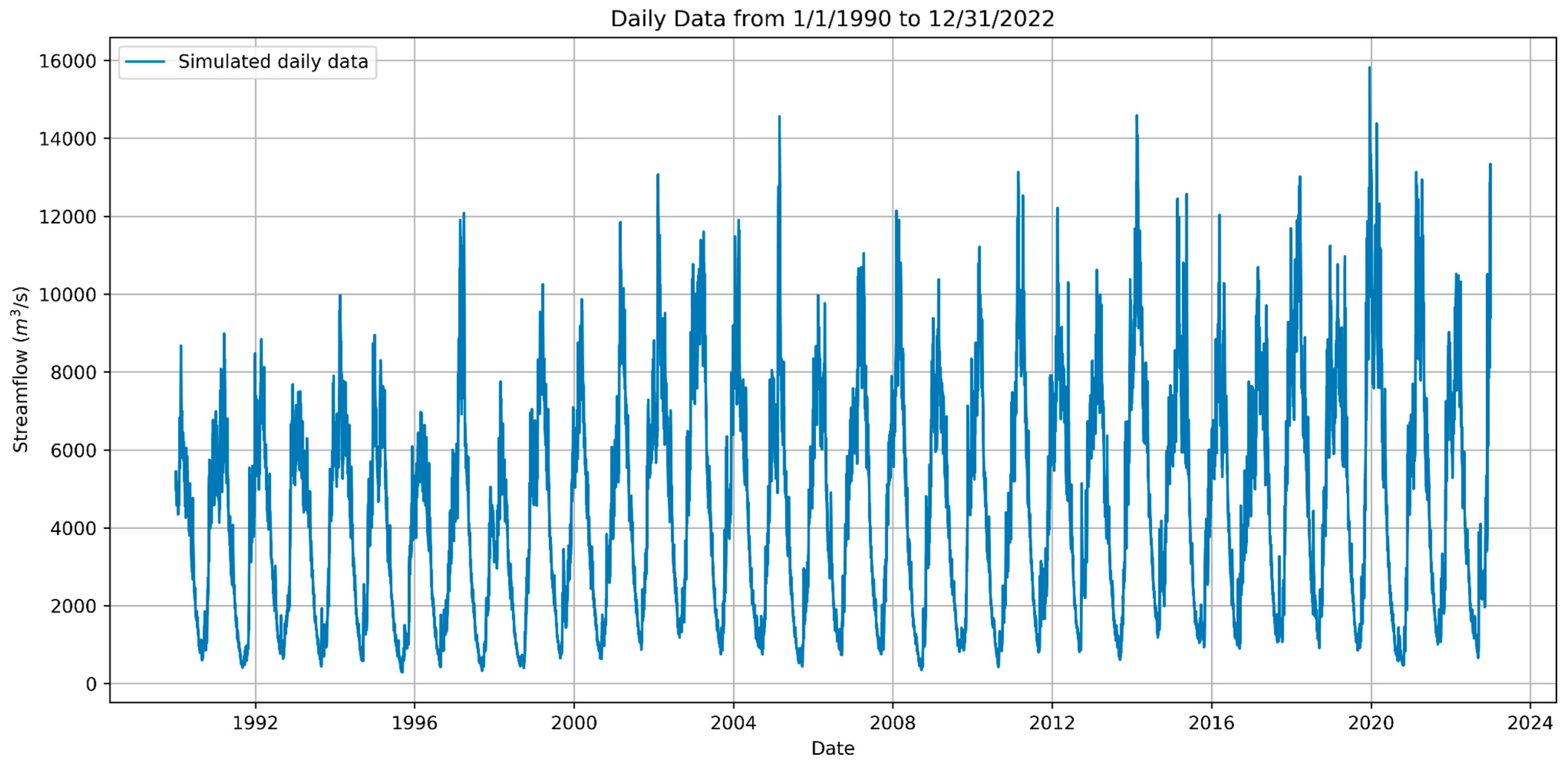
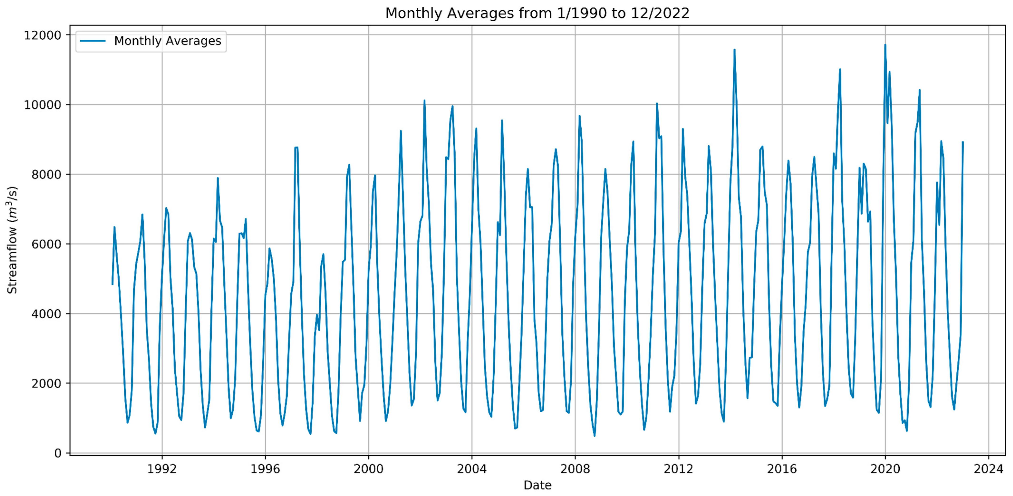
Appendix A. Streamflow Simulation in the MDD Basin (Amaru Mayu Station)
References
- Ceballos, G.; Ehrlich, P.R. Global mammal distributions, biodiversity hotspots, and conservation. Proc. Natl. Acad. Sci. USA 2006, 103, 19374–19379. [Google Scholar] [CrossRef] [PubMed]
- Markham, K.E. Sangermano, Florencia. Evaluating wildlife vulnerability to mercury pollution from artisanal and small-scale gold mining in Madre de Dios, Peru. Trop. Conserv. Sci. 2018, 11, 1940082918794320. [Google Scholar] [CrossRef]
- Myers, N.; Mittermeier, R.A.; Mittermeier, C.G.; Da Fonseca, G.A.; Kent, J. Biodiversity hotspots for conservation priorities. Nature 2000, 403, 853–858. [Google Scholar] [CrossRef] [PubMed]
- Asner, G.P.; Knapp, D.E.; Martin, R.E.; Tupayachi, R.; Anderson, C.B.; Mascaro, J.; Sinca, F.; Chadwick, K.D.; Higgins, M.; Farfan, W.; et al. Targeted carbon conservation at national scales with high-resolution monitoring. Proc. Natl. Acad. Sci. USA 2014, 111, E5016–E5022. [Google Scholar] [CrossRef] [PubMed]
- Asner, G.P.; Tupayachi, R. Accelerated losses of protected forests from gold mining in the Peruvian Amazon. Environ. Res. Lett. 2017, 12, 094004. [Google Scholar] [CrossRef]
- Telmer, K.H.; Veiga, M.M. World emissions of mercury from artisanal and small scale gold mining. In Mercury Fate and Transport in the Global Atmosphere: Emissions, Measurements and Models; Springer US: Boston, MA, USA, 2009; pp. 131–172. [Google Scholar]
- Ashe, K. Elevated mercury concentrations in humans of Madre de Dios, Peru. PLoS ONE 2012, 7, e33305. [Google Scholar] [CrossRef]
- Martinez, G.; McCord, S.A.; Driscoll, C.T.; Todorova, S.; Wu, S.; Araújo, J.F.; Vega, C.M.; Fernandez, L.E. Mercury contamination in riverine sediments and fish associated with artisanal and small-scale gold mining in Madre de Dios, Peru. Int. J. Environ. Res. Public Health 2018, 15, 1584. [Google Scholar] [CrossRef]
- Gonzalez, D.J.; Arain, A.; Fernandez, L.E. Mercury exposure, risk factors, and perceptions among women of childbearing age in an artisanal gold mining region of the Peruvian Amazon. Environ. Res. 2019, 179, 108786. [Google Scholar] [CrossRef]
- Gerson, J.; Topp, S.; Vega, C.M.; Gardner, J.; Yang, X.; Fernández, L.E.; Bernhardt, E.; Pavelsky, T. Artisanal Gold Mining Ponds Amplify Mercury Risk in the Peruvian Amazon (Research Brief CINCIA #7); Centro de Innovación Científica Amazónica: Puerto Maldonado, Peru, 2021. [Google Scholar]
- Caballero, J.; Messinger, M.; Román-Dañobeytia, F.; Ascorra, C.; Fernandez, L.E.; Silman, M. Deforestation and forest degradation due to gold mining in the Peruvian Amazon: A 34-year perspective. Remote Sens. 2018, 10, 1903. [Google Scholar] [CrossRef]
- Householder, J.E.; Janovec, J.P.; Tobler, M.W.; Page, S.; Lähteenoja, O. Peatlands of the Madre de Dios River of Peru: Distribution, geomorphology, and habitat diversity. Wetlands 2012, 32, 359–368. [Google Scholar] [CrossRef]
- Liang, J.; Wu, K.; Li, Y.; Wei, Z.; Zhuo, P.; Yan, Q.; Luo, X. Impacts of large-scale rare earth mining on surface runoff, groundwater, and evapotranspiration: A case study using SWAT for the Taojiang River Basin in Southern China. Mine Water Environ. 2019, 38, 268–280. [Google Scholar] [CrossRef]
- Arnold, J.G.; Kiniry, J.R.; Srinivasan, R.; Williams, J.R.; Haney, E.B.; Neitsch, S.L. SWAT 2012 Input/Output Documentation. Texas Water Resources Institute 2013. Available online: https://hdl.handle.net/1969.1/149194 (accessed on 5 December 2023).
- De Oliveira Serrão, E.A.; Silva, M.T.; Ferreira, T.R.; de Ataide LC, P.; dos Santos, C.A.; de Lima AM, M.; Gomes DJ, C. Impacts of land use and land cover changes on hydrological processes and sediment yield determined using the SWAT model. Int. J. Sediment Res. 2022, 37, 54–69. [Google Scholar] [CrossRef]
- Abe, C.A.; Lobo, F.D.L.; Dibike, Y.B.; Costa, M.P.D.F.; Dos Santos, V.; Novo, E.M.L. Modeling the effects of historical and future land cover changes on the hydrology of an Amazonian basin. Water 2018, 10, 932. [Google Scholar] [CrossRef]
- Baker, T.J.; Miller, S.N. Using the Soil and Water Assessment Tool (SWAT) to assess land use impact on water resources in an East African watershed. J. Hydrol. 2013, 486, 100–111. [Google Scholar] [CrossRef]
- Fassoni-Andrade, A.C.; Fleischmann, A.S.; Papa, F.; de Paiva, R.C.D.; Wongchuig, S.; Melack, J.M.; Moreira, A.A.; Paris, A.; Ruhoff, A.; Barbosa, C.; et al. Amazon hydrology from space: Scientific advances and future challenges. Rev. Geophys. 2021, 59, e2020RG000728. [Google Scholar] [CrossRef]
- Tuo, Y.; Duan, Z.; Disse, M.; Chiogna, G. Evaluation of precipitation input for SWAT modeling in Alpine catchment: A case study in the Adige river basin (Italy). Sci. Total Environ. 2016, 573, 66–82. [Google Scholar] [CrossRef]
- Huffman, G.J.; Bolvin, D.T.; Nelkin, E.J.; Wolff, D.B.; Adler, R.F.; Gu, G.; Hong, Y.; Bowman, K.P.; Stocker, E.F. The TRMM multisatellite precipitation analysis (TMPA): Quasi-global, multiyear, combined-sensor precipitation estimates at fine scales. J. Hydrometeorol. 2007, 8, 38–55. [Google Scholar] [CrossRef]
- Schwaller, M.R.; Morris, K.R. A Ground Validation Network for the Global Precipitation Measurement Mission. J. Atmos. Ocean. Technol. 2011, 28, 301–319. [Google Scholar] [CrossRef]
- Funk, C.; Verdin, A.; Michaelsen, J.; Peterson, P.; Pedreros, D.; Husak, G. A global satellite-assisted precipitation climatology. Earth Syst. Sci. Data 2015, 7, 275–287. [Google Scholar] [CrossRef]
- de Paiva, R.C.D.; Buarque, D.C.; Collischonn, W.; Bonnet, M.-P.; Frappart, F.; Calmant, S.; Bulhões Mendes, C.A. Large-scale hydrologic and hydrodynamic modeling of the Amazon River basin. Water Resour. Res. 2013, 49, 1226–1243. [Google Scholar] [CrossRef]
- Zubieta, R.; Getirana, A.; Espinoza, J.C.; Lavado-Casimiro, W.; Aragon, L. Hydrological modeling of the Peruvian–Ecuadorian Amazon Basin using GPM-IMERG satellite-based precipitation dataset. Hydrol. Earth Syst. Sci. 2017, 21, 3543–3555. [Google Scholar] [CrossRef] [PubMed]
- Balcázar, L.; Bâ, K.M.; Díaz-Delgado, C.; Quentin, E.; Minga-León, S. Modelado de caudales diarios en una cuenca del sur del Ecuador con precipitación y temperatura estimadas por satélite. Agrociencia 2019, 53, 465–486. [Google Scholar]
- CPC Global Unified Temperature Data Provided by the NOAA PSL, Boulder, Colorado, USA. Available online: https://psl.noaa.gov (accessed on 29 March 2023).
- Diringer, S.E.; Berky, A.J.; Marani, M.; Ortiz, E.J.; Karatum, O.; Plata, D.L.; Pan, W.K.; Hsu-Kim, H. Deforestation due to artisanal and small-scale gold mining exacerbates soil and mercury mobilization in Madre de Dios, Peru. Environ. Sci. Technol. 2019, 54, 286–296. [Google Scholar] [CrossRef] [PubMed]
- Swenson, J.J.; Carter, C.E.; Domec, J.C.; Delgado, C.I. Gold mining in the Peruvian Amazon: Global prices, deforestation, and mercury imports. PLoS ONE 2011, 6, e18875. [Google Scholar] [CrossRef] [PubMed]
- Callan, N.; De la Cruz, A.; Guerrero, L.; Santillan, B.; Langendoen, E.; Moreno, M. Bedform Dynamics in the Mining-Impacted Madre de Dios River, Peruvian Amazon. Research Brief. River Mining Project (PEER 8-235). 2023. Available online: https://cincia.wfu.edu/category/publicaciones/ (accessed on 5 December 2023).
- Castro, A.; Dávila, C.; Laura, W.; Cubas Saucedo, F.; Ávalos, G.; López, C.; Villena, D.; Valdez, M.; Urbiola, J.; Trebejo, I.; et al. Climas del Perú: Mapa de Clasificación Climática Nacional. Servicio Nacional de Meteorología e Hidrología del Perú (SENAMHI) 2021. Available online: https://pesquisa.bvsalud.org/portal/resource/pt/biblio-1292421 (accessed on 10 December 2021).
- Finer, M.; Ariñez, A.; Mamani, N. Deforestación por Minería de Oro en la Amazonía 2023. MAAP: 178. Available online: https://maaproject.org/2023/mineria-amazonia/ (accessed on 3 March 2023).
- Hansen, M.C.; Potapov, P.V.; Moore, R.; Hancher, M.; Turubanova, S.A.; Tyukavina, A.; Thau, D.; Stehman, S.V.; Goetz, S.J.; Loveland, T.R.; et al. High-resolution global maps of 21-st-century forest cover change. Science 2013, 342, 850–853. Available online: https://www.globalforestwatch.org/map/ (accessed on 24 July 2023). [CrossRef] [PubMed]
- Infografías de los Datos de la Cobertura y Pérdida de Bosques al 2018. Programa Nacional de Conservación de Bosque para la Mitigación del Cambio Climático 2019. Available online: https://sinia.minam.gob.pe/documentos/infografias-datos-cobertura-perdida-bosques-2018 (accessed on 31 January 2023).
- Aybar, C.; Fernández, C.; Huerta, A.; Lavado, W.; Vega, F.; Felipe-Obando, O. Construction of a high-resolution gridded rainfall dataset for Peru from 1981 to the present day. Hydrol. Sci. J. 2020, 65, 770–785. [Google Scholar] [CrossRef]
- Bennett, N.D.; Croke, B.F.; Guariso, G.; Guillaume, J.H.; Hamilton, S.H.; Jakeman, A.J.; Andreassian, V. Characterising performance of environmental models. Environ. Model. Softw. 2013, 40, 1–20. [Google Scholar] [CrossRef]
- Observatorio del Agua. Sistema Nacional de Información de los Recursos Hídricos. Autoridad Nacional del Agua. Available online: https://snirh.ana.gob.pe/ObservatorioSNIRH/ (accessed on 12 August 2022).
- Farr, T.G.; Rosen, P.A.; Caro, E.; Crippen, R.; Duren, R.; Hensley, S.; Kobrick, M.; Paller, M.; Rodriguez, E.; Roth, L.; et al. The shuttle radar topography mission. Rev. Geo-Phys. 2007, 45, RG2004. [Google Scholar] [CrossRef]
- FAO. Soil Map of the World; United Nations Educational, Scientific, and Cultural Organization; UNESCO: Paris, France, 1995. [Google Scholar]
- USGS. Global Land Cover Characterization; United State Geological Survey: Washington, DC, USA, 1997. [Google Scholar]
- Arnold, J.G.; Srinivasan, R.; Muttiah, R.S.; Williams, J.R. Large area hydrologic modeling and assessment part I: Model development 1. JAWRA J. Am. Water Resour. Assoc. 1998, 34, 73–89. [Google Scholar] [CrossRef]
- Gassman, P.W.; Reyes, M.R.; Green, C.H.; Arnold, J.G. The soil and water assessment tool: Historical development, applications, and future research directions. Trans. ASABE 2007, 50, 1211–1250. [Google Scholar] [CrossRef]
- Neitsch, S.L.; Arnold, J.G.; Kiniry, J.R.; Williams, J.R. Soil and Water Assessment Tool Theoretical Documentation Version 2009. Texas Water Resources Institute 2011. Available online: https://swat.tamu.edu/media/99192/swat2009-theory.pdf (accessed on 10 June 2021).
- Dile, Y.T.; Daggupati, P.; George, C.; Srinivasan, R.; Arnold, J. Introducing a new open source GIS user interface for the SWAT model. Environ. Model. Softw. 2016, 85, 129–138. [Google Scholar] [CrossRef]
- Daggupati, P.; Pai, N.; Ale, S.; Doulgas-Mankin, K.R.; Zeckoski, R.; Jeong, J.; Parajuli, P.; Saraswat, D.; Youssef, M. A recommended calibration and validation strategies for hydrological and water quality models. Trans. ASABE 2015, 58, 1705–1719. [Google Scholar]
- Moriasi, D.N.; Arnold, J.G.; Van Liew, M.W.; Bingner, R.L.; Harmel, R.D.; Veith, T.L. Model evaluation guidelines for systematic quantification of accuracy in watershed simulations. Trans. ASABE 2007, 50, 885–900. [Google Scholar] [CrossRef]
- Nash, J.E.; Sutcliffe, J.V. River flow forecasting through conceptual models: Part 1. d A discussion of principles. J. Hydrol. 1970, 10, 282–290. [Google Scholar] [CrossRef]
- Gupta, H.; Sorooshian, S.; Yapo, P. Status of automatic calibration for hydro- logic models: Comparison with multilevel expert calibration. J. Hydrol. Eng. 1999, 4, 135–143. [Google Scholar] [CrossRef]
- Moriasi, D.N.; Pai, N.; Steiner, J.L.; Gowda, P.H.; Winchell, M.; Rathjens, H.; Starks, P.J.; Verser, J.A. SWAT-LUT: A desktop graphical user interface for updating land use in SWAT. JAWRA J. Am. Water Resour. Assoc. 2019, 55, 1102–1115. [Google Scholar] [CrossRef]
- Vargas, C.; Montalban, J.; Leon, A.A. Early warning tropical forest loss alerts in Peru using Landsat. Environ. Res. Commun. 2019, 1, 121002. [Google Scholar] [CrossRef]
- Soares-Filho, B.S.; Nepstad, D.C.; Curran, L.M.; Cerqueira, G.C.; Garcia, R.A.; Ramos, C.A.; Voll, E.; McDonald, A.; Lefebvre, P.; Schlesinger, P. Modelling conservation in the Amazon basin. Nature 2006, 440, 520–523. [Google Scholar] [CrossRef]
- Dos Santos, V.; Laurent, F.; Abe, C.; Messner, F. Hydrologic response to land use change in a large basin in eastern Amazon. Water 2018, 10, 429. [Google Scholar] [CrossRef]
- Abbaspour, K.C. SWAT-CUP: SWAT Calibration and Uncertainty Programs—A User Manual; Eawag: Dübendorf, Switzerland, 2015; 103p. [Google Scholar]
- Abbaspour, K.C.; Vaghefi, S.A.; Srinivasan, R. A guideline for successful calibration and uncertainty analysis for soil and water assessment: A review of papers from the 2016 international SWAT conference. Water 2017, 10, 6. [Google Scholar] [CrossRef]
- Abbaspour, K.C.; Rouholahnejad, E.; Vaghefi, S.A.; Srinivasan, R.; Yang, H.; Kløve, B. A continental-scale hydrology and water quality model for Europe: Calibration and uncertainty of a high-resolution large-scale SWAT model. J. Hydrol. 2015, 524, 733–752. [Google Scholar] [CrossRef]
- Strauch, M.; Volk, M. SWAT plant growth modification for improved modeling of perennial vegetation in the tropics. Ecol. Model. 2013, 269, 98–112. [Google Scholar] [CrossRef]
- Kreibich, H.; Van Loon, A.F.; Schröter, K.; Ward, P.J.; Mazzoleni, M.; Sairam, N.; Abeshu, G.W.; Agafonova, S.; AghaKouchak, A.; Aksoy, H.; et al. The challenge of unprecedented floods and droughts in risk management. Nature 2022, 608, 80–86. [Google Scholar] [CrossRef] [PubMed]
- García-Rivero, A.E.; Olivera, J.; Salinas, E.; Yuli, R.A.; Bulege, W. Use of hydrogeomorphic indexes in SAGA-GIS for the characterization of flooded areas in Madre de Dios, Peru. Int. J. Appl. Eng. Res. 2017, 12, 9078–9086. [Google Scholar]
- Abuhay, W.; Gashaw, T.; Tsegaye, L. Assessing impacts of land use/land cover changes on the hydrology of Upper Gilgel Abbay watershed using the SWAT model. J. Agric. Food Res. 2023, 12, 100535. [Google Scholar] [CrossRef]
- Zhang, H.; Wang, B.; Liu, D.L.; Zhang, M.; Leslie, L.M.; Yu, Q. Using an improved SWAT model to simulate hydrological responses to land use change: A case study of a catchment in tropical Australia. J. Hydrol. 2020, 585, 124822. [Google Scholar] [CrossRef]
- Gashaw, T.; Tulu, T.; Argaw, M.; Worqlul, A.W. Modeling the hydrological impacts of land use/land cover changes in the Andassa watershed, Blue Nile Basin, Ethiopia. Sci. Total Environ. 2018, 619, 1394–1408. [Google Scholar] [CrossRef]



| Input Data | Spatial Resolution | Source |
|---|---|---|
| Precipitation | 0.05° (~5 km) | CHIRPS v2.0 [22] |
| Temperature | 0.5° (~55 km) | CPC Global Unified Temperature [26] |
| Digital Elevation Model | 30 m | SRTM [37] |
| Soil type map | 1:5,000,000 | FAO v3.6 [38] |
| Land use cover map | ~0.5 km | GLCC—USGS v2 [39] |
| Observed streamflow | - | ANA [36] |
| Performance Rating | NS 1 | PBIAS 2 | RSR 3 |
|---|---|---|---|
| Very good | 0.75 ≤ NS ≤ 1.00 | PBIAS ≤ ±15% | 0 ≤ RSR ≤ 0.5 |
| acceGood | 0.65 ≤ NS ≤ 0.75 | ±15% ≤ PBIAS ≤ ±30% | 0.5 ≤ RSR ≤ 0.6 |
| Satisfactory | 0.5 ≤ NS ≤ 0.65 | ± 30% ≤ PBIAS ≤ ±55% | 0.6 ≤ RSR ≤ 0.7 |
| Unsatisfactory | NS ≤ 0.5 | PBIAS ≥ ±55% | RSR ≥ 0.7 |
| Description | Parameter | Default Value | Calibrated Range | Fitted Value |
|---|---|---|---|---|
| Curve number for moisture condition II. | CN2.mgt_FOEB 1 | 72 | 0–98 | 46.2 |
| CN2.mgt_GRAS 1 | 81 | 0–98 | 52.1 | |
| CN2.mgt_SHRB 1 | 76 | 0–98 | 48.8 | |
| Baseflow alpha factor (1/days). | ALPHA_BF.gw | 0.048 | 0–1 | 1 |
| Threshold depth of water in the shallow aquifer required for return flow to occur (mm H2O). | GWQMN.gw | 1000 | 0–5000 | 2009.1 |
| Groundwater “revap” coefficient. | GWREVAP.gw | 0.02 | 0.02–0.2 | 0.08 |
| Threshold depth of water in the shallow aquifer for “revap” or percolation to the deep aquifer to occur (mm H2O). | REVAPMN.gw | 750 | 0–500 | 322 |
| Groundwater delay time (days). | GW_DELAY.gw | 31 | 30–450 | 60.26 |
| Effective hydraulic conductivity in main channel alluvium (mm/h). | CH_K2.rte | 0 | 0–250 | 51.4 |
| Manning’s “n” value for the main channel. | CH_N2.rte | 0.014 | 0.01–0.3 | 0.06 |
| Soil evaporation compensation factor. | ESCO.hru | 1 | 0.01–1 | 0.98 |
| Plant uptake compensation factor. | EPCO.hru | 0.95 | 0.01–1 | 1 |
| Saturated hydraulic conductivity (mm/h) | SOL_K.sol_FOEB 1 | 8.93 | 0–2000 | 9.4 |
| SOL_K.sol_GRAS 1 | 24.83 | 0–2000 | 26.14 | |
| SOL_K.sol_SHRB 1 | 37.59 | 0–2000 | 39.6 |
| Hydrological Component | Jan | Feb | Mar | Apr | May | Jun | Jul | Aug | Sep | Oct | Nov | Dec |
|---|---|---|---|---|---|---|---|---|---|---|---|---|
| Percentage Change% | ||||||||||||
| SURQ | 45.7 | 24.7 | 25.2 | 27.8 | 19.4 | 54.5 | 47 | 35.2 | 34.4 | 35.1 | 21.6 | 23.9 |
| LATQ | 2.1 | 2.6 | 2.3 | 2.0 | 1.7 | 1.7 | 2.6 | 3.4 | 3.0 | 2.8 | 2.9 | 2.6 |
| WY | 0.1 | 1.3 | 0.5 | 0.3 | −0.6 | −1.9 | −3.0 | −4.2 | −0.8 | 0.8 | 2.5 | 2.1 |
| ET | −0.04 | −0.9 | −2.7 | −2.8 | −1.3 | 0.1 | 0.1 | 0.1 | 0 | −0.1 | −0.04 | −0.04 |
| GWQ | −4.1 | −4.0 | −4.0 | −3.9 | −3.9 | −4.3 | −5.3 | −6.6 | −6.6 | −4.3 | −3.8 | −4.0 |
| Scenario | SURQ | LATQ | GWQ | WY | PERC | ET |
|---|---|---|---|---|---|---|
| Baseline | 215.6 | 269.1 | 1337.1 | 1821.5 | 1503.8 | 669.8 |
| Deforested scenario | 272.1 | 275.6 | 1281.5 | 1829 | 1447.2 | 663.3 |
| % change | 26.2 | 2.4 | −4.2 | 0.4 | −3.8 | −1 |
Disclaimer/Publisher’s Note: The statements, opinions and data contained in all publications are solely those of the individual author(s) and contributor(s) and not of MDPI and/or the editor(s). MDPI and/or the editor(s) disclaim responsibility for any injury to people or property resulting from any ideas, methods, instructions or products referred to in the content. |
© 2023 by the authors. Licensee MDPI, Basel, Switzerland. This article is an open access article distributed under the terms and conditions of the Creative Commons Attribution (CC BY) license (https://creativecommons.org/licenses/by/4.0/).
Share and Cite
Paiva, K.; Rau, P.; Montesinos, C.; Lavado-Casimiro, W.; Bourrel, L.; Frappart, F. Hydrological Response Assessment of Land Cover Change in a Peruvian Amazonian Basin Impacted by Deforestation Using the SWAT Model. Remote Sens. 2023, 15, 5774. https://doi.org/10.3390/rs15245774
Paiva K, Rau P, Montesinos C, Lavado-Casimiro W, Bourrel L, Frappart F. Hydrological Response Assessment of Land Cover Change in a Peruvian Amazonian Basin Impacted by Deforestation Using the SWAT Model. Remote Sensing. 2023; 15(24):5774. https://doi.org/10.3390/rs15245774
Chicago/Turabian StylePaiva, Karla, Pedro Rau, Cristian Montesinos, Waldo Lavado-Casimiro, Luc Bourrel, and Frédéric Frappart. 2023. "Hydrological Response Assessment of Land Cover Change in a Peruvian Amazonian Basin Impacted by Deforestation Using the SWAT Model" Remote Sensing 15, no. 24: 5774. https://doi.org/10.3390/rs15245774
APA StylePaiva, K., Rau, P., Montesinos, C., Lavado-Casimiro, W., Bourrel, L., & Frappart, F. (2023). Hydrological Response Assessment of Land Cover Change in a Peruvian Amazonian Basin Impacted by Deforestation Using the SWAT Model. Remote Sensing, 15(24), 5774. https://doi.org/10.3390/rs15245774


