Abstract
The concept of rapid growth (RG) of tropical cyclones (TCs) in the north Atlantic basin was recently proposed. RG can represent a dangerous change in TC structure because it can rapidly ramp up the TC destructive potential. However, the nature of RG behaviour remains obscure over the western north Pacific (WNP), where nearly one third of global TCs occur. In this study, TC RG in the WNP is investigated using TC best-tracks and reanalysis of data. We first define TC RG in the WNP as an increase of at least 84 km in the radius of a gale-force wind within 24 h, corresponding to the 90th percentile of all over-water changes. Monte Carlo experiments demonstrate the robustness of the threshold. Similar to that occurring in the north Atlantic, RG in the WNP is associated with the highest level of destructive potential. In addition, RG over the WNP occurs closer to the coast than for TCs in the Atlantic and more RG events in the WNP are accompanied by rapid intensification, which may significantly increase their destructive potential in a worst case scenario. Composite analysis shows that certain dynamic processes, such as radial inflow, may play an important role in the occurrence of RG. This study suggests that, apart from rapid intensification, TC RG is another important factor to consider for TC-related risk assessment in the WNP.
1. Introduction
Tropical cyclones (TCs) are one of the most severe types of natural weather phenomena that threaten densely populated and highly developed coastal regions [1]. Aside from the intensity, the outer size of the cyclone also strongly influences the overall destructiveness of a TC [2,3,4]. A dramatic increase in TC intensity, referred to as rapid intensification (RI), has been extensively investigated and been shown to exert a substantial influence on the development of the most severe TCs [5,6]. In contrast, rapid growth (RG) in the outer size of TCs has received little attention until recently [7]. Using best-track data, ref. [7] (hereafter, L22) defined RG for north Atlantic (NA) TCs and reported its significant influence on the TC lifecycle and destructive potential [7]. However, L22 only examined TCs over the NA. Compared with the NA, the western north Pacific (WNP) hosts nearly one-third of global TCs [8], which have caused some of the most destructive natural disasters in east Asia [9]. Therefore, it is important, from both scientific and practical perspectives, to conduct statistical analyses of RG in the WNP and the ambient and oceanic conditions that potentially influence their occurrence.
In the literature, several metrics are used to describe TC outer size, including the radius of the outermost closed isobar, the radius of the hurricane-force wind (60 kt), the radius of the damaging-force wind (50 kt), and the radius of the gale-force wind (34 kt) [10,11,12,13,14]. The operating agencies routinely gather and predict the radius of the hurricane-force, damaging-force, and gale-force winds [15,16]. The average radius of the gale-force winds (R) is used in this study due to its importance in determining TC potential impacts [17] and the relatively wider availability of data in operational products [18].
Similar to L22, we first define the RG in the WNP using the isolation forest algorithm, a widely used unsupervised objective anomaly detection algorithm [19,20]. We also compare the percentile-based thresholds because they are practically convenient and, thus, widely used operationally [21]. The authors of L22 chose the 90th percentile of all 24 h over-water changes in R, which is discussed further below.
From observational and theoretical perspectives, previous studies have shown that variations in TC outer-size are influenced by mid-level humidity, low-level radial inflow, and baroclinic instability. The intrusion of mid-level dry air favors growth in size as the horizontal heating gradient and secondary circulation are enhanced in the outer rain-band [22]. The lower-level radial inflow, or angular momentum flux, increases the cyclonic circulation [23]. In addition, the baroclinic instability triggers extra-tropical transitions during which the wind field expands [24]. L22 showed that these three processes contribute to the development of RG in the north Atlantic. RG is characterized by a lower 600 hPa relative humidity (RH) in the outer rainbands, a higher 850 hPa radial inflow, and a higher 700 hPa Eady growth rate. In this study, we examine how these processes impact the RG of TCs over WNP, and whether there are common influential factors in both basins. L22 did not exclude the effect of the RG geographic location and seasonality when analyzing the influence of oceanic variables, which is investigated in this study.
The paper is organized as follows: Section 2 introduces the approach to data pre-processing and the main methodology, especially use of the isolation forest algorithm. Section 3 describes the statistical characteristics of RG and of the TCs undergoing RG (hereafter, RG TCs). In addition, the atmospheric and oceanic conditions which potentially influence RG are also explored. Section 4 discusses the main results and Section 5 concludes the paper with the key findings.
2. Data and Methods
We use TC best-track data to calculate the size changes, which were obtained from the International Best-Track Archive for Climate Stewardship (IBTrACS) [25]. In IBTrACS, the size measurements are obtained from the Joint Typhoon Warning Center (JTWC). Following L22, we only select TCs to the south of 40N to partly remove the potential influence of extra-tropical transition. Moreover, no data used here was labeled as extra-tropical in the IBTrACS dataset. Only the TC tracks that were over the ocean are selected and all cases are at least 100 km from the coastline.
Therefore, the influence of topography is reduced. Following L22 and other studies of RI and rapid weakening [21,26], we only use the TC measurements for the following times: 00, 06, 12, 18 coordinated universal time (UTC), and calculate the intensification and growth rates as the change in the maximum surface wind speed (V) and R over each 24 hr period. Therefore, RG and RI may occur for consecutive 24 h periods; the interval between each event is 6 h and some of the events can overlap. We also use atmospheric and oceanic reanalysis data, including the 600 hPa relative humidity, 850 hPa wind speed, 700 hPa atmospheric temperature and the sea surface temperature, to analyze the environmental conditions. These variables were obtained from the fifth generation of the ECMWF reanalysis (ERA5) dataset [27]. The horizontal and temporal resolutions of the ERA5 data are 0.25 and six hours, respectively.
The isolation forest method [19,20] is used to provide an objective threshold of RG. As an objective anomaly detection algorithm, isolation forest detects anomalies using binary trees, specifically, isolation trees. The algorithm first computes an anomaly score for each point, after which it recursively splits the values concerned and isolates them from the others. The score of a point is the average path length from the tree’s root to the node of a tree containing a single point; a short path indicates a point that is easy to isolate. The isolation forest algorithm was obtained from the scikit-learn package (https://scikit-learn.org/stable/modules/generated/sklearn.ensemble.IsolationForest.html, accessed on 12 January 2022, Version 1.0.2) in a Python environment (Version 3.8.2). Following L22, the automatic method is used in this study to detect anomalies, where the path lengths are smaller than the average of the scores of all points [19]. As described above, percentile-based thresholds are usually favored in practice, so we also compare the 90th and 95th percentiles of all 24 h R changes. The ability of these thresholds to explain the climatological distribution of TC size and their destructive potential is then compared.
Two metrics that measure the TC destructive potential, the integrated kinetic energy (IKE) [2] and the integrated power dissipation (IPD) [28,29] are used. Before calculating these metrics, we use the revised Holland parametric model [30] to provide a complete wind-profile estimation.
IKE is defined as,
where S is the integral area within R.
IPD is defined as,
where is the drag coefficient calculated with the wind speed.
3. Results
3.1. Definition of RG
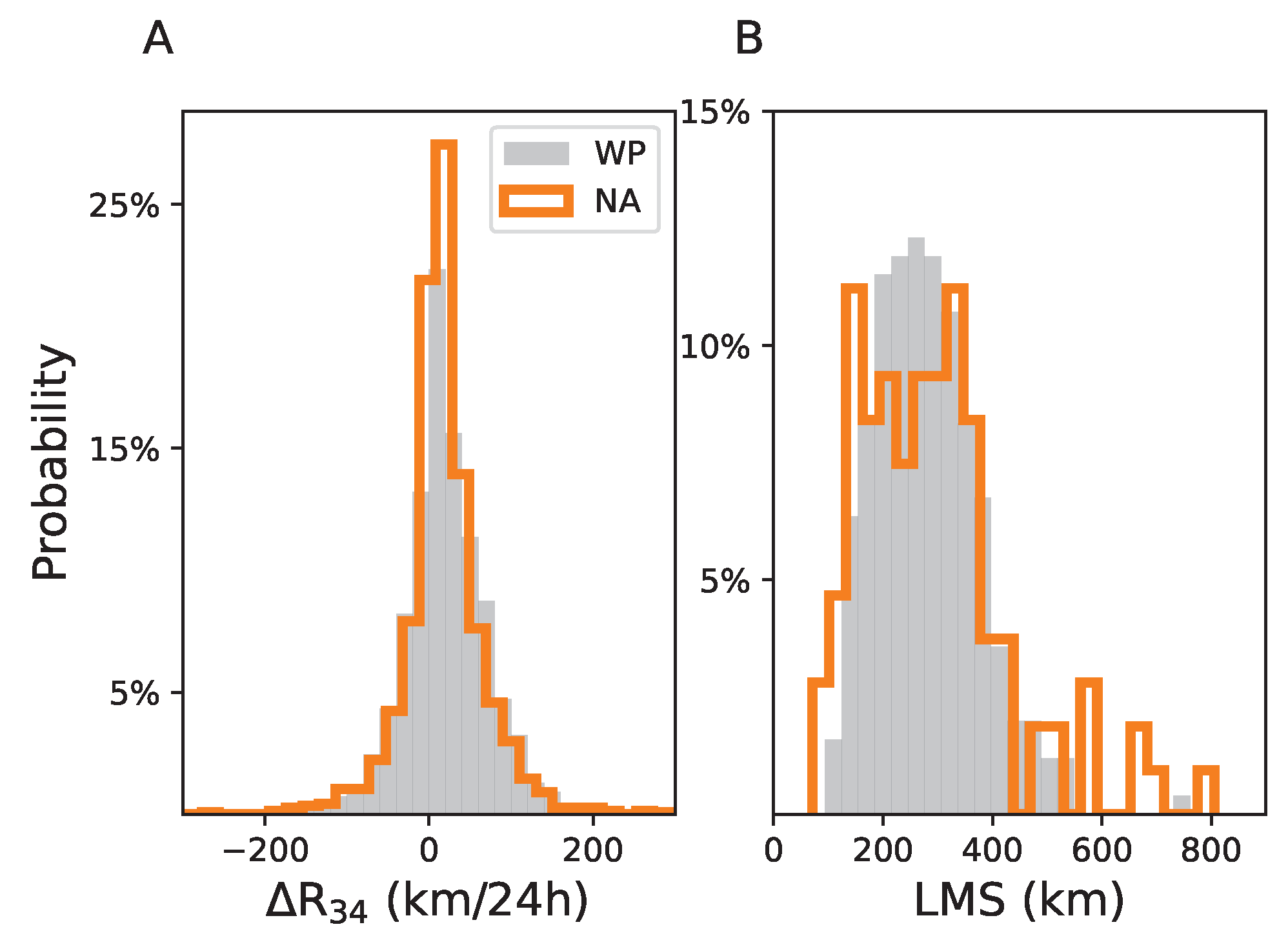
There are 252 TCs and 4,636 24-h R changes (R) extracted from the WNP ’best-track’ data. Figure 1A compares the distributions of R between WNP and NA. It is evident that R follows a Gaussian distribution (p-value < 0.01 in the Shapiro–Wilk test) in both basins. The mean and standard deviation of R are 20 and 52 km for WP, while the values are 19 and 53 km for NA. The lifetime maximum size (LMS), however, shows different distributions for the two basins (Figure 1B). For the north Atlantic TCs, as noted by L22, two local maxima exist at around 180 km and 350 km, with a hint of a third maximum at 600–650 km. On the other hand, only one peak exists at approximately 300 km for LMS in WP, which is also Gaussian-distributed (p-value < 0.01 in the Shapiro–Wilk test), with a mean and standard deviation of 280 and 95 km, respectively.
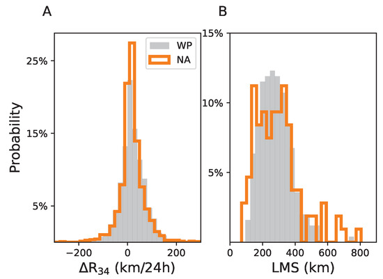
Figure 1.
Distribution of (A) R (units: km/24 h) and (B) lifetime maximum size (LMS, units: km) for the western north Pacific (grey) and north Atlantic TCs (orange).
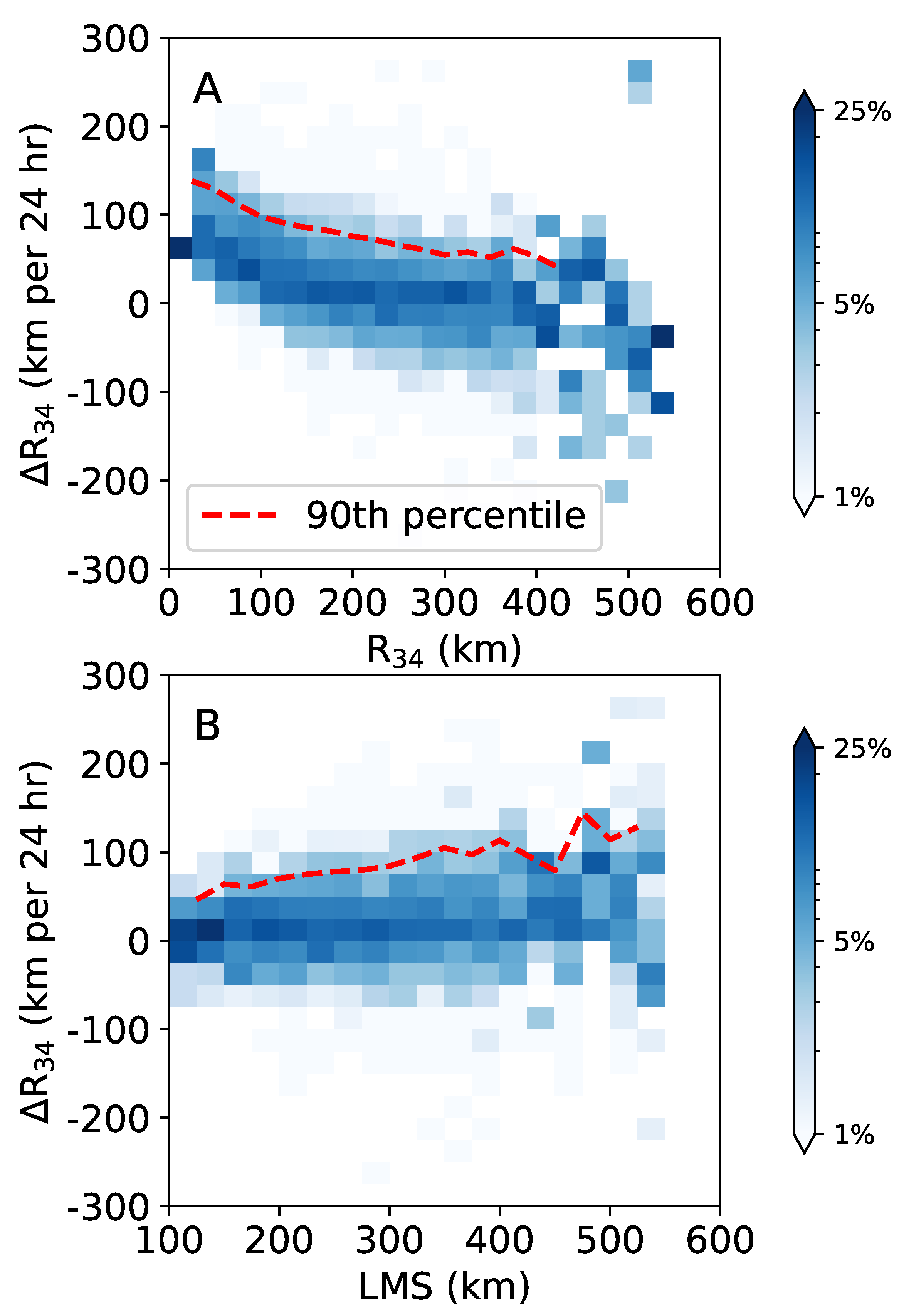
Growth in TC outer size is potentially influenced by the initial state of the TC wind structure. Figure 2A shows the joint frequency distributions of 24 h R changes and the initial R during each 24 h interval. The 24 h R changes decrease almost linearly with the initial R. It is evident that R tends to increase more rapidly when the initial R is smaller. However, this does not mean that RG tends to occur among the small TCs. Figure 2B shows that the 24 h R changes increase with the lifetime maximum size (LMS). These results are in line with the findings of previous studies [12,31].

Figure 2.
The ratio of 24 h R changes as a function of (A) the initial R during each 24 h interval and (B) the lifetime maximum size (LMS) for the western north Pacific. The y-axis in each subplot relates to the 24 h R changes (units: km/24 h) and the x-axis shows the initial R and LMS (units: km). The unit for the blue shadings is %. The red line shows the 90th percentile for each pixel.
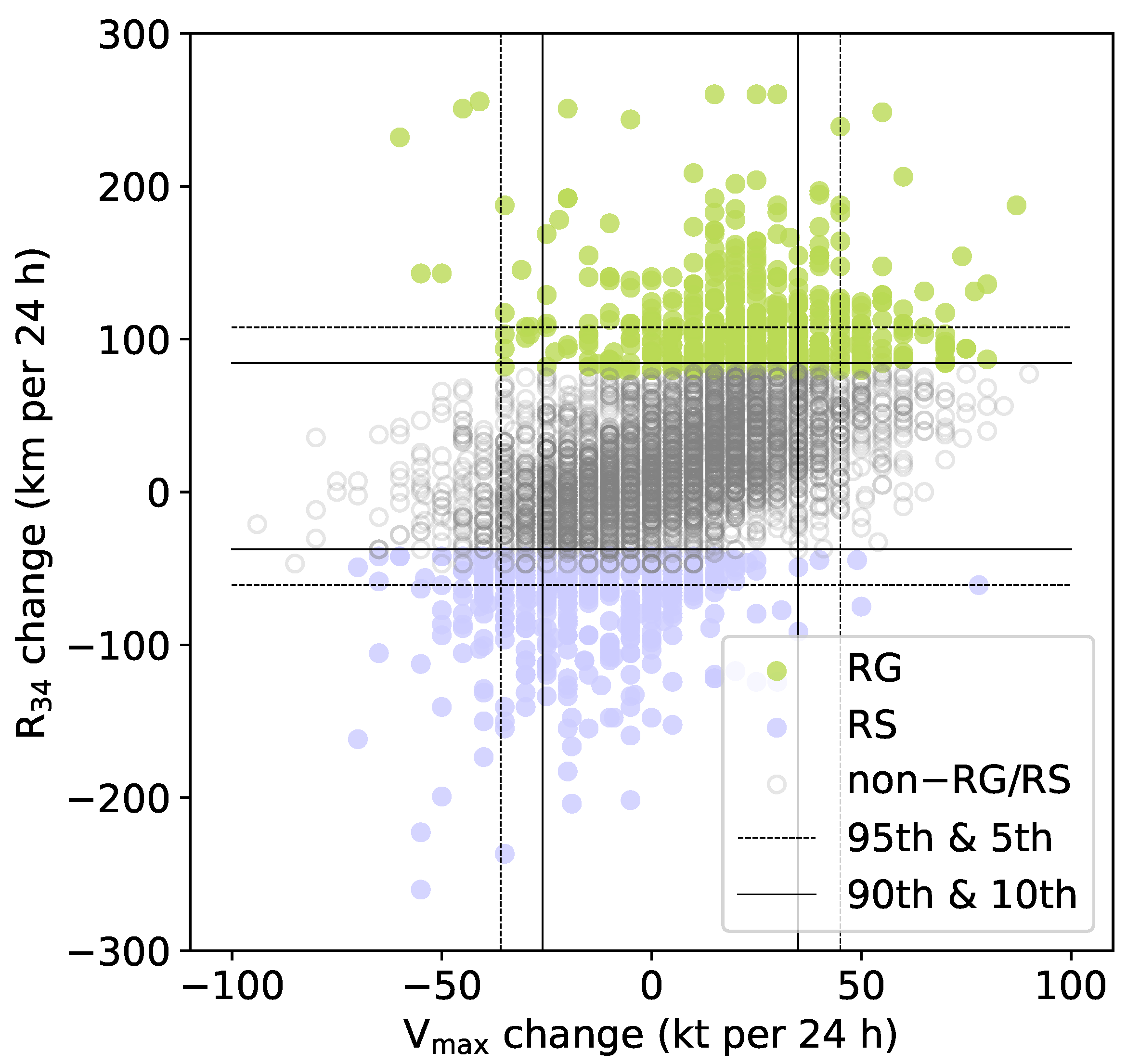
A total of 546 events are classified as RG events by isolation forest, while 397 cases are defined as rapid shrinking (Figure 3). For the RG type, the minimum increase in R is 80 km/24 h, while for the rapid-shrinking cluster, R decreases by at least 42 km in 24 h. These thresholds correspond to the 89th and 9th percentiles, respectively. L22 compared the threshold of the 95th and 90th percentiles with the isolation forest-based threshold. Here, we also examine the performance of the percentile-based thresholds. Figure 3 shows that, compared to the choice of the 95th and 5th percentiles, the 90th and 10th percentiles provide closer results to those with the objective thresholds.
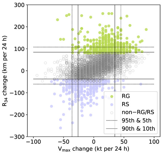
Figure 3.
Distribution of intensity change (units: kt/24 h) and R (units: km/24 h). The rapid growth (RG) and rapid shrinkage events identified by the isolation forest algorithm are denoted by green and purple dots, respectively, while the events not identified as RG or RS are denoted by grey circles. The thresholds of the 95th (5th) and 90th (10th) percentiles are denoted by dashed and solid lines, respectively.
In addition, only 244 events are classified as RG when the 95th percentile (108 km/24 h) is used. In contrast, with a threshold of the 90th percentile (84 km/24 h), 487 events are classified as RG and a larger sample size is usually favored in practice.
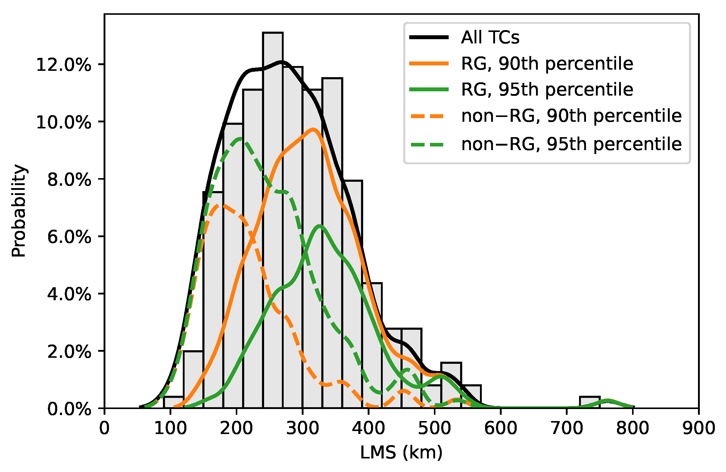
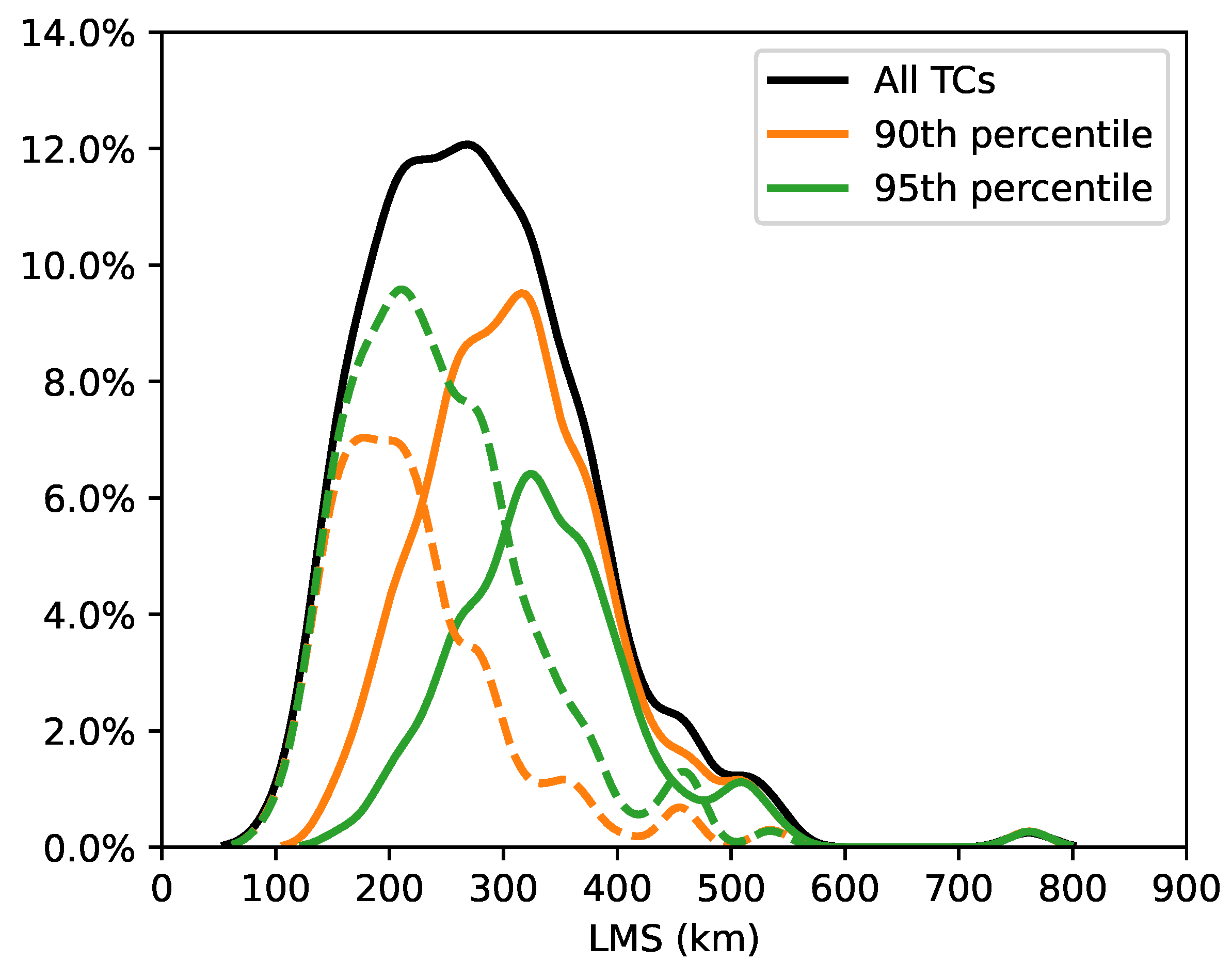
We then further compare the two thresholds of the 90th and 95th percentiles in terms of their ability to explain the distribution of LMS (Figure 4). With a threshold of the 90th percentile, the RG TCs (the orange line) account for the majority (90%, 84/94) of the large TCs (LMS > 300 km, which is approximately the mean of the LMS). The non-RG TCs, on the other hand, are mainly small ones. In contrast, if the threshold of the 95th percentile is used, only approximately 50% of the large TCs are RG TCs (the green line). The authors of [5] demonstrated that RI is the major contributor to the development of intense TCs and the results here indicate that RG plays a similar role for the TC outer size. Therefore, the threshold of the 90th percentile (84 km/24 h) is selected in the following analysis as it is supported by both the isolation forest and offers a better explanation for the climatology of LMS. Correspondingly, the threshold for rapid shrinking was set to 10% (−38 km/24 h). However, we only focus on RG in the following text since it contributes more to destructiveness and, thus, represents a bigger threat. With such a threshold, 162 of the 252 TCs undergo at least one RG event during their lifetime. It is also noteworthy that 39% (192/487) of the RG events also undergo RI, while the proportion is only 22% (33/147) for the Atlantic. The onset timing was also similar between RI and RG events over WNP. RG and RI occur at 77 ± 48 h (mean ± standard deviation) and 74 ± 44 h after TC genesis, respectively. Table 1 summarizes the counts for RG and RI TCs for WNP and NA.
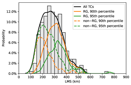
Figure 4.
Probability distribution function (PDF) of the lifetime maximum size (LMS) for the western north Pacific TCs. The original and smoothed distribution of all TCs are denoted by the grey histograms and black lines, respectively. The smoothed PDFs for the TCs that undergo rapid growth, defined as the 90th percentile (≥84 km/24 h) and 95th (108 km/24 h) percentile, are denoted by the orange and green lines, respectively. The PDFs are smoothed using kernel density estimation with a bandwidth of 0.2.

Table 1.
Count of rapid growth (RG) and rapid intensification (RI) TCs for the north Atlantic and western north Pacific.
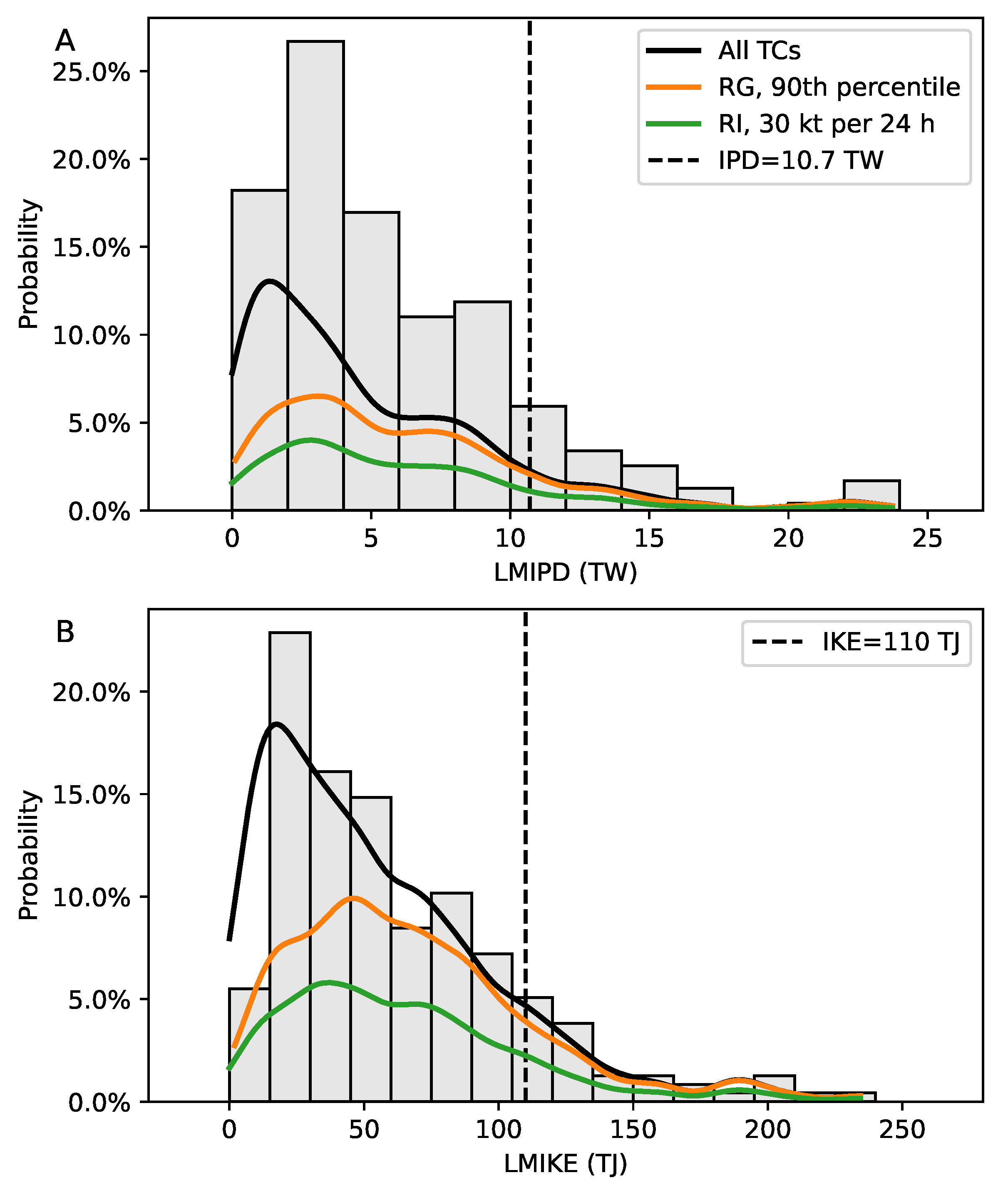
Enormous effort has been invested in the study of RI, which is a major contributor to the development of the most severe TCs and worst damage. Here, we show that, RG may be a more powerful process than RI for dramatically increasing the overall destructive potential, as measured by either the lifetime maximum integrated kinetic energy (LMIKE, Figure 5A) or the lifetime maximum integrated power dissipation (LMIPD, Figure 5B). We find that more TCs with the highest destructive potential underwent RG rather than RI. For instance, if only the 25 TCs with the top 10% destructive potential are considered, 22 are RG TCs (the orange line), while only 15 undergo RI (the green line). Therefore, compared with the extensively studied RI, RG may play a more important role in controlling the destructive potential of TCs. It should be emphasized that the growth we discuss here only refers to the outer-size, while growth in the inner-core size is closely linked with TC intensity [32,33].
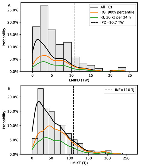
Figure 5.
Probability distribution function (PDF) of the (A) lifetime maximum integrated power dissipation (LMIPD) and (B) lifetime maximum integrated kinetic energy (LMIKE) for the western north Pacific TCs. The original and smoothed distribution of all TCs are denoted by the grey histograms and black line, respectively. The PDFs for the TCs that undergo rapid growth, defined as the 90th percentile (≥84 km/24 h), and TCs undergoing RI (≥30 kt/24 h), are denoted by the orange and green lines, respectively. The PDFs are smoothed using kernel density estimation with a bandwidth of 0.2. IPD and IKE are computed using the revised Holland wind-profile model [30].
Previous studies have indicated that a distinctive life cycle occurs for TC intensity, regardless of whether RI occurs or not [34,35].
However, the outer-size life cycle is only recognizable among the RG TCs over the north Atlantic, as reported by L22. Similar results were obtained here for the WNP TCs. Figure 6A depicts the R life-cycles for the RG and non-RG TCs. Typically, R of the RG TCs expand from about 200 km to more than 300 km within a 48 h period before reaching LMS. After reaching LMS, R rapidly drops to around 240 km within 24 h. For the non-RG TCs, however, the R remains around 150 to 200 km during the entire lifetime, with no continuous growth or shrinkage.
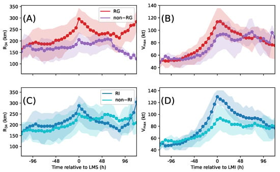
Figure 6.
Composite of the evolution of (A) R and (B) V for the RG and non-RG TCs. (C) and (D) are the same with (A) and (B), but for the RI and non-RI TCs. The solid lines represent the average values, while the shadows represent one standard deviation.
In contrast, as for the intensity, RG and non-RG TCs both show clear and similar evolution patterns (Figure 6B). The RG TCs show slightly higher lifetime maximum intensity (LMI) and faster weakening than the non-RG TCs. However, the highest intensification rate is around 40 kt/24 h for both types, indicating that variations in TC intensity and outer size are independent of each other.
As a comparison, we further analyze the size and intensity life cycles of RI and non-RI TCs (Figure 6C,D). Their sizes evolve similarly and remain relatively steady. The highest growth rate of R, with a value of around 60 km/24 h, emerges 24 h before the TC achieving LMS (Figure 6C). The LMS is 280 km and 250 km for the RI and non-RI TCs, respectively. Figure 6A,C show that RG is the dominant factor in the growth of R, especially for the TCs that can achieve a clear LMS. In contrast, although their intensity diverges significantly, there are discernible intensification processes for both RI and non-RI types within 24 to 48 h before LMI (Figure 6D). This behavior of the intensity life cycle is fundamentally different from that of the size cycle. Comparing Figure 6A and Figure 6D, it is evident that RG plays a fundamental role in the lifecycle of TC outer size, while RI is not critical for the evolution of intensity.
3.2. Spatial and Temporal Distributions of RG
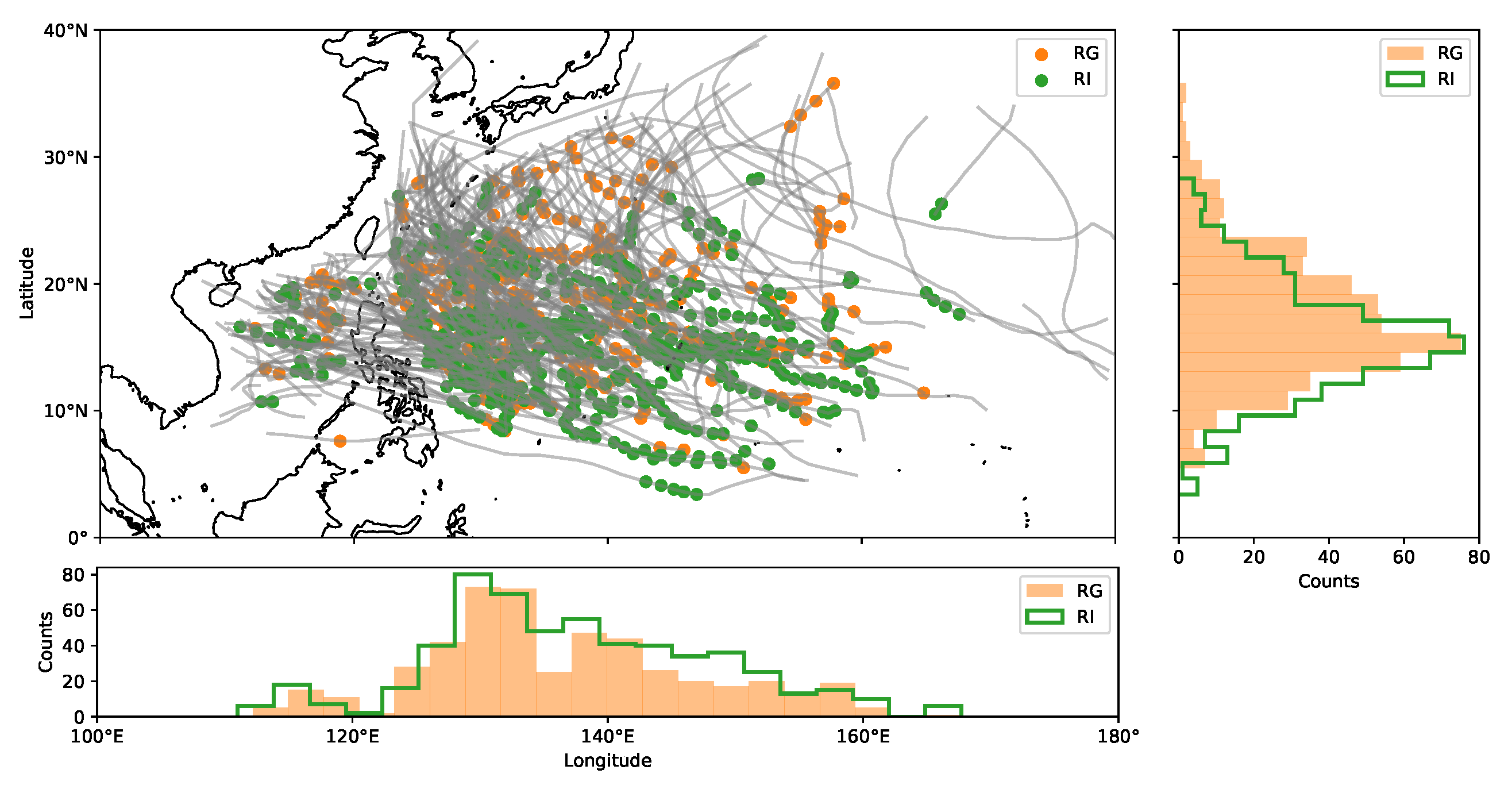
L22 showed that, compared with RI events, RG tends to occur at higher latitudes (p < 0.01). In contrast, as shown in Figure 7, the locations of RG over WNP are similar to those of RI. The majority of RG events happen to the south of 30N, with an average latitude of 17.4N. RI events occur on average at 15.9 N. As a comparison, the average latitude for RG and RI is 24.7N and 19.1N over the north Atlantic. The longitudes of RG and RI events are also similar and are uniformly scattered in the South China Sea and western north Pacific, with a mean distance-to-land of 2006 and 2130 km, respectively. It is noteworthy that 17.2% of RG events occur in regions within 800 km from the coastline, a greater proportion than that of RI events (15.2%). Such rapid changes in the coastal regions are more likely to result in lower forecast capacity and more TC-related hazards.

Figure 7.
Spatial distribution of rapid growth (orange) and rapid intensification (green) events.
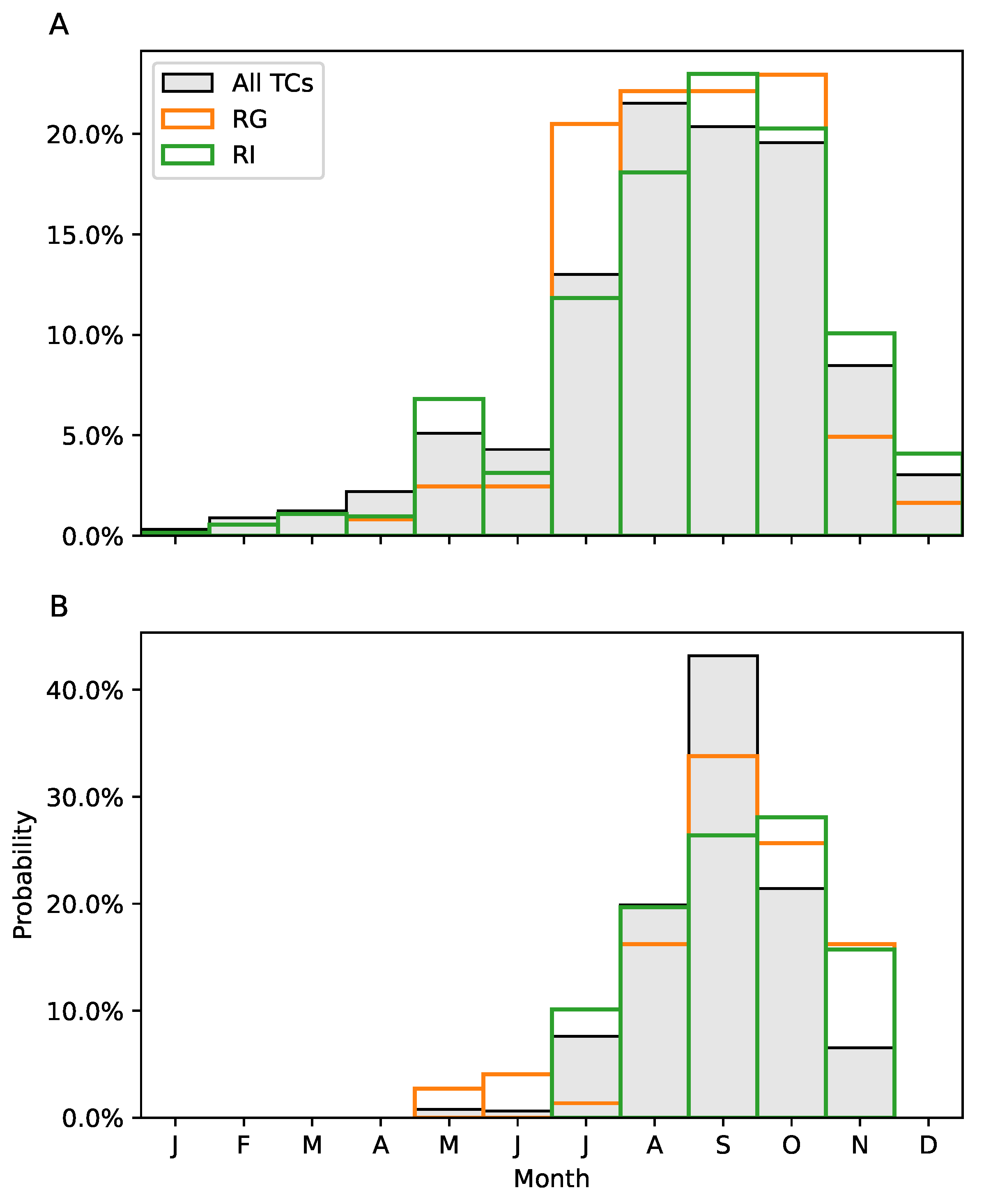
The temporal distributions are also compared between RI and RG events over the two basins (Figure 8). For WNP, TCs occur throughout the year; the peak TC season starts in July and ends in November. The temporal distribution of RI is identical to that of all TCs, while RG tends to occur in late summer to early autumn. In contrast, for the north Atlantic basin, RG can occur as early as May, while RI does not happen until July.

Figure 8.
Temporal distribution of rapid growth (orange) and rapid intensification (green) events for the (A) western north Pacific and (B) north Atlantic basins.
3.3. Environmental Conditions
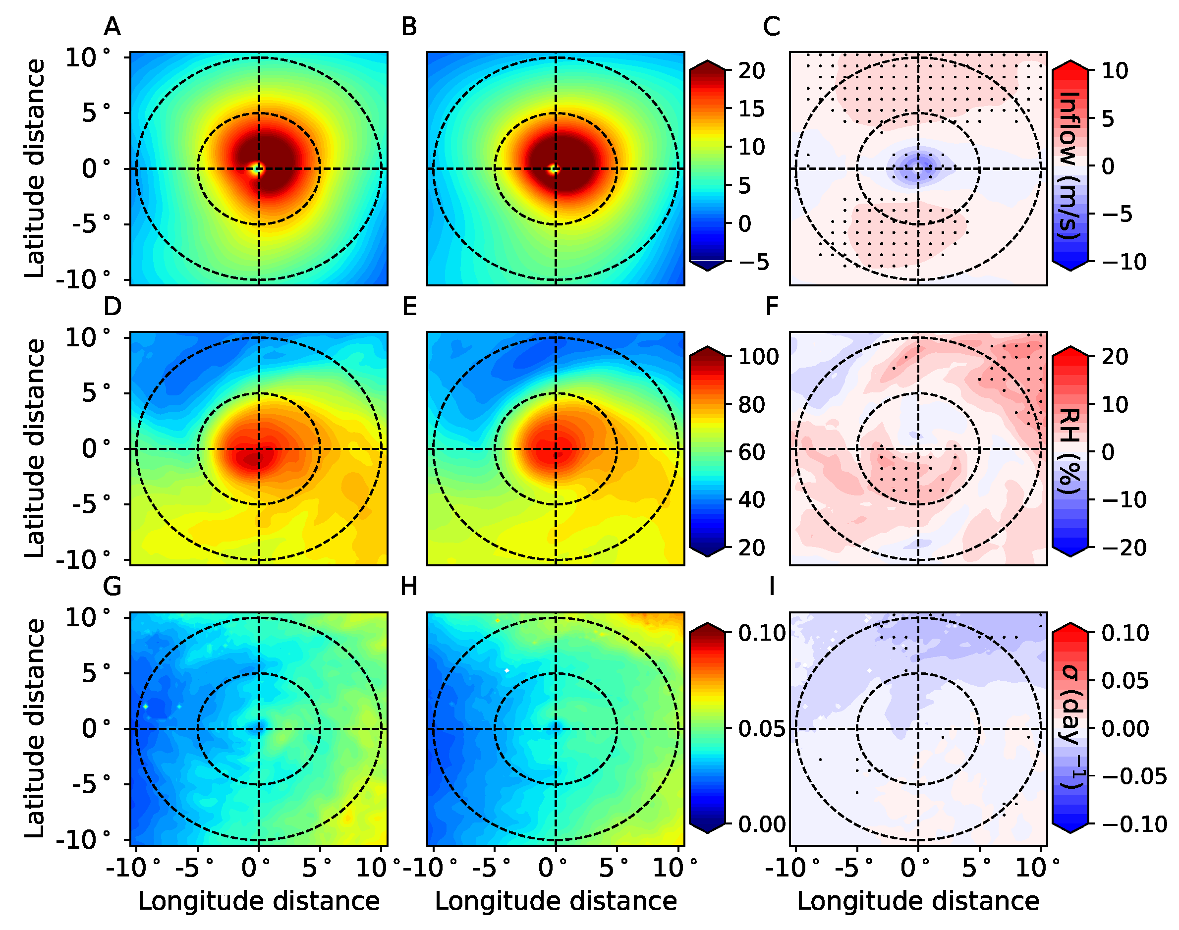
In this section, we compare the ambient atmospheric and oceanic conditions between the RG and non-RG cases. Several atmospheric factors influence the evolution of TC outer size, including the change in diabatic heating in the rainbands [12,22,36], the lower-tropospheric angular momentum flux [23] and the baroclinic instability [37]. L22 showed that RG over the north Atlantic basin is associated with the intrusion of mid-level dry air, higher low-level inflow, and a higher 700 hPa Eady growth rate. However, different environmental conditions are observed for WNP. As shown in Figure 9, although a stronger radial inflow (positive) is still observed for the RG TCs, the results for the other two factors are different from those for the north Atlantic Ocean.
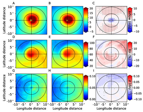
Figure 9.
The atmospheric conditions within a 21 × 21 box with the TC centered. (A) and (B) depict the composite 850 hPa radial inflow (units: m/s) for the RG and non-RG events, and (C) shows the difference between (A) and (B). (D–F) are the same with (A–C), but for the 600 hPa relative humidity (RH, units: %). (G–I) are the same as (A–C), but for the 700 hPa Eady growth rate (, units: day). The factors are composited using data from the ERA5 reanalysis. Stippled areas in the right panel indicate that the differences are statistically significant at the 99% confidence level based on Student’s t-test. The two circles are placed at radii of 5 and 10 degrees from the TC center.
The composite maps, as shown in Figure 9, of low-level radial inflow, mid-level relative humidity, and mid-level baroclinic instability during the TC passage show the difference in atmospheric conditions between RG and non-RG events. Similar to L22, a stronger low-level angular momentum input, as represented by the 850 hPa stronger radial inflow, is found for the RG events. The similar intensity (68 vs. 69 kt, p = 0.45) and R (178 vs. 175 km, p = 0.38) between RG and non-RG events indicate that the difference in radial inflow is mainly caused by the large-scale environment. Over most of the domain, a higher 850 hPa radial inflow can be observed for RG (Figure 9A–C), especially outside the 5 radius from the TC center. The average inflow for the RG group is 8.0 m/s in the 21 × 21 box, while it is 7.5 m/s for the non-RG group.
In contrast, the thermodynamic factors, including the relative humidity and baroclinic instability, are different between the north Atlantic and the western north Pacific. For the north Atlantic, L22 reported a significantly lower mid-level humidity for RG TCs than for non-RG TCs outside the 5 radius. However, here, we find that the mid-level relative humidity is slightly higher for RG TCs than for the non-RG TCs over the majority of the 21× 21 box (Figure 9D–F). The difference between the present study and L22 could be caused by the dominant effect of the Saharan dry-air layer over the Atlantic [26]. In addition, RI and RG are more likely to co-occur in WNP than in NA, and wetter mid-level air favors the TC intensification [38]. In addition, the 700 hPa Eady growth rate (), which shows the regions favoring baroclinic development [37], is similar between the two types. The RG cases occur with lower (Figure 9G–I), but the difference is not statistically significant over most of the domain.
The ocean temperature influences TC development as the ocean fuels the overlaying TC systems. L22 reported a lower SST for the RG TCs, but such a cooler surface could be attributed to the higher latitude of RG events over the north Atlantic. Here, we compare the spatial distribution of SST two days before approach of a TC (Figure 10). The pre-storm SST for RG is higher by 0.2 C than for the non-RG events (29.1 C and 28.9 C, respectively) in the northern part, and lower by 0.2 C (29.4 C and 29.5 C, respectively) in the southern part. This weaker gradient in SST corresponds to the lower baroclinic instability (Figure 9I). However, the difference is not significant over most of the domain. Therefore, the above composite analysis of atmospheric and oceanic conditions demonstrates that dynamic processes are likely to dominate the development of RG events over WNP, while, over the north Atlantic, thermodynamic processes also play a significant role.
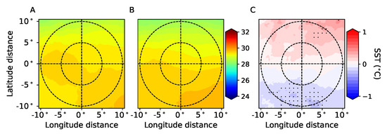
Figure 10.
Composite maps of sea-surface temperature of (A) RG and (B) non-RG events and (C) the difference between (A) and (B). SST data are from the ERA5 reanalysis and are obtained for two days before TC approach. The units for x- and y-axis are degrees. Stippled areas in the right panel indicate that the differences are statistically significant at the 99% confidence level based on Student’s t-test. The two circles are placed at radii of 5 and 10 degrees from the TC center.
4. Discussion
The destructiveness of tropical cyclones (TCs) is significantly affected by their intensity and their outer size, which is usually measured as the gale-force wind radius (R). Rapid intensification has been extensively explored. In contrast, the potential influence of rapid growth was not analyzed until recently in [7], where the concept of rapid growth for north Atlantic TCs was proposed. As an important supplement to L22, we investigate here the characteristics and influences of rapid growth for the western north Pacific, where more TC-caused hazards take place. We show that, similar to the results for the north Atlantic, RG can be defined as the 90th (84 km/24 h) percentile of all 24 h R change over water, which is similar to what is achieved by an unsupervised anomaly detection algorithm. The threshold of the 90th percentile also explains the distribution of the lifetime maximum size, LMS, by representing most of the peak with a larger LMS (over 300 km). RG is also the crucial driver of the distinct TC size lifecycle and its high destructive potential. RG events mainly happen from July to October, with locations usually being close to the coast. In addition, approximately 40% of RG events co-occur with RI. In contrast, RG over the north Atlantic are often further from the coast and seldom co-occur with RI. Therefore, RG is more threatening in WNP and may cause more damage in east Asia. However, it should be noted that we did not consider the TC inner-core structure, which has a close link with change in intensity [32,33,39,40]. Analyses of the relationship between the inner and outer size, including the amplitudes, timing, and latitude, are also required. In addition, we only analyzed the absolute change in R, while the relative change could be explored further in future studies.
The robustness of the above results depends heavily on the quality of the TC size measurements; the uncertainty in the best-track data over WNP is higher than NA due to the lack of aircraft-based measurements. Thus, Monte Carlo experiments are conducted to estimate the influence of uncertainty of best-track observation, in which 10,000 samples are produced by adding random noise to each R value. The uncertainty with R measurements could be as high as 30 nautical miles (55 km) for satellite-only observations [41,42]. The random noise is drawn from a Gaussian distribution with a mean of 0 and a standard deviation of 55 km. Figure 11 shows the probability distribution of LMS generated from the Monte Carlo experiments, which is very similar to the original distribution (Figure 4). The distributions of RG and non-RG TCs confirm that, even taking into account uncertainty of up to 55 km, the threshold of 84 km/24 h explains the frequency of medium and large TCs well, indicating the robustness of the proposed threshold. Nevertheless, more accurate observations are needed; the uncertainties are expected to decrease with improved observation facilities. The difference in data quality between WNP and NA could also contribute to the difference in RG characteristics, though reanalysis data have been widely used for the investigation of the TC environment [23,43].
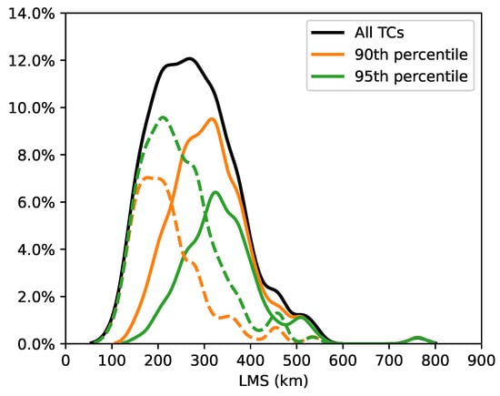
Figure 11.
Same as Figure 4, but for the results in the Monte Carlo experiment.
Therefore, direct observations obtained by satellites and aircraft should be further explored. In addition, in this study, we did not consider the asymmetric distribution of Ry. Such a distribution fundamentally affects the average R and destructiveness and could be further explored in future studies.
Composite analysis shows that the dynamic process is the key environmental factor dominating RG events for WNP. The authors of [23] analyzed the synoptic low-level flow and found that radial inflow plays an important role in outer size growth in the WNP. We also show that the thermodynamic processes in the WNP are different from those in the north Atlantic. While dry mid-level air was found for the RG TCs in the north Atlantic, RG TCs were characterized by higher relative humidity in the WNP. Such differences could be attributed to the different background sounding over the two basins. For instance, drier mid-level air was found for the rapid weakening events over the north Atlantic [44]; ref. [26] noted that mid-level humidity is not important for the development of rapid weakening over the WNP and that the dry Saharan mid-level layer explains this difference. The influence of such environmental conditions on TC intensity has been extensively investigated [38,40,43] and, thus, is not investigated here. For instance, a higher relative humidity favors TC eyewall replacement and intensification [38,45]. More case studies and numerical simulations are required to better understand the underlying mechanism of RG. In addition, we only consider the destructive potential; the actual destructiveness caused by wind, storm surge, and precipitation could be investigated in future studies.
5. Conclusions
This study analyzes the rapid growth of western north Pacific TCs and highlights its substantial impact. We show that: (1) RG can be defined as the 90th (84 km/24 h) percentile of all 24 h R changes over water; (2) RG dominates the development of the TC size lifecycle and increase in TC destructive potential; and (3) dynamic processes play a crucial role in the RG events. This investigation can be further improved in several ways: First, case studies can be performed using satellite and radar observations with higher resolution. Second, numerical studies are required to isolate the effect of different environmental factors and background sounding. Lastly, future work could include analysis of data of actual damage, including that caused by storm surges and precipitation, to validate the impact of RG.
Author Contributions
Conceptualization, Y.L., Y.T. and S.W.; methodology, Y.L.; formal analysis, Y.L. and S.W.; writing—original draft preparation, Y.L.; writing—review and editing, Y.T. and S.W.; visualization, Y.L. and X.L.; supervision, Y.T. All authors have read and agreed to the published version of the manuscript.
Funding
This study was sponsored by the National Natural Science Foundation of China (42006036, 42130409), Hohai university (522020512) and the Singapore Green Finance Centre.
Data Availability Statement
The TC best-track data used in this study is IBTrACS Version 4 (v4r00) retrieved from https://www.ncdc.noaa.gov/ibtracs/index.php (accessed on 10 February 2022). The ERA5 reanalysis data is from https://cds.climate.copernicus.eu#!/home (accessed on 17 August 2022).
Conflicts of Interest
The authors declare no conflict of interest.
References
- Weinkle, J.; Landsea, C.; Collins, D.; Musulin, R.; Crompton, R.P.; Klotzbach, P.J.; Pielke, R. Normalized hurricane damage in the continental United States 1900–2017. Nat. Sustain. 2018, 1, 808–813. [Google Scholar] [CrossRef]
- Powell, M.D.; Reinhold, T.A. Tropical Cyclone Destructive Potential by Integrated Kinetic Energy. Bull. Am. Meteorol. Soc. 2007, 88, 513–526. [Google Scholar] [CrossRef]
- Zhai, A.R.; Jiang, J.H. Dependence of US hurricane economic loss on maximum wind speed and storm size. Environ. Res. Lett. 2014, 9, 064019. [Google Scholar] [CrossRef]
- Wang, S.; Toumi, R. On the relationship between hurricane cost and the integrated wind profile. Environ. Res. Lett. 2016, 11, 114005. [Google Scholar] [CrossRef]
- Lee, C.Y.; Tippett, M.K.; Sobel, A.H.; Camargo, S.J. Rapid intensification and the bimodal distribution of tropical cyclone intensity. Nat. Commun. 2016, 7, 10625. [Google Scholar] [CrossRef]
- Phillipson, L.; Li, Y.; Toumi, R. Strongly coupled assimilation of a hypothetical ocean current observing network within a regional ocean–atmosphere Coupled Model: An OSSE case study of Typhoon Hato. Mon. Weather Rev. 2021, 149, 1317–1336. [Google Scholar] [CrossRef]
- Li, Y.; Tang, Y.; Wang, S. Rapid Growth of Outer Size of Tropical Cyclones: A New Perspective on Their Destructive Potential. Geophys. Res. Lett. 2022, 49. [Google Scholar] [CrossRef]
- Balaguru, K.; Foltz, G.R.; Leung, L.R.; Emanuel, K.A. Global warming-induced upper-ocean freshening and the intensification of super typhoons. Nat. Commun. 2016, 7, 13670. [Google Scholar] [CrossRef]
- Peduzzi, P.; Chatenoux, B.; Dao, H.; De Bono, A.; Herold, C.; Kossin, J.; Mouton, F.; Nordbeck, O. Global trends in tropical cyclone risk. Nat. Clim. Chang. 2012, 2, 289–294. [Google Scholar] [CrossRef]
- Kimball, S.K.; Mulekar, M.S. A 15-Year Climatology of North Atlantic Tropical Cyclones. Part I: Size Parameters. J. Clim. 2004, 17, 3555–3575. [Google Scholar] [CrossRef]
- Merrill, R.T. A Comparison of Large and Small Tropical Cyclones. Mon. Weather Rev. 1984, 112, 1408–1418. [Google Scholar] [CrossRef]
- Wang, S.; Toumi, R. An analytic model of the tropical cyclone outer size. Npj Clim. Atmos. Sci. 2022, 5, 46. [Google Scholar] [CrossRef]
- Xu, J.; Wang, Y. Sensitivity of the Simulated Tropical Cyclone Inner-Core Size to the Initial Vortex Size. Mon. Weather Rev. 2010, 138, 4135–4157. [Google Scholar] [CrossRef]
- Chan, K.T.F.; Chan, J.C.L. Size and Strength of Tropical Cyclones as Inferred from QuikSCAT Data. Mon. Weather Rev. 2012, 140, 811–824. [Google Scholar] [CrossRef]
- Knaff, J.A.; Sampson, C.R.; DeMaria, M.; Marchok, T.P.; Gross, J.M.; McAdie, C.J. Statistical Tropical Cyclone Wind Radii Prediction Using Climatology and Persistence. Weather Forecast. 2007, 22, 781–791. [Google Scholar] [CrossRef]
- Knaff, J.A.; Sampson, C.R.; Chirokova, G. A Global Statistical–Dynamical Tropical Cyclone Wind Radii Forecast Scheme. Weather Forecast. 2017, 32, 629–644. [Google Scholar] [CrossRef]
- Wu, L.; Tian, W.; Liu, Q.; Cao, J.; Knaff, J.A. Implications of the Observed Relationship between Tropical Cyclone Size and Intensity over the Western North Pacific. J. Clim. 2015, 28, 9501–9506. [Google Scholar] [CrossRef]
- Knaff, J.A.; Sampson, C.R. After a Decade Are Atlantic Tropical Cyclone Gale Force Wind Radii Forecasts Now Skillful? Weather Forecast. 2015, 30, 702–709. [Google Scholar] [CrossRef]
- Liu, F.T.; Ting, K.M.; Zhou, Z.H. Isolation Forest. In Proceedings of the 2008 Eighth IEEE International Conference on Data Mining, Pisa, Italy, 15–19 December 2008; pp. 413–422. [Google Scholar] [CrossRef]
- Liu, F.T.; Ting, K.M.; Zhou, Z.H. Isolation-Based Anomaly Detection. ACM Trans. Knowl. Discov. Data 2012, 6, 1–39. [Google Scholar] [CrossRef]
- Kaplan, J.; DeMaria, M. Large-scale characteristics of rapidly intensifying tropical cyclones in the North Atlantic basin. Weather Forecast. 2003, 18, 1093–1108. [Google Scholar] [CrossRef]
- Wang, S.; Toumi, R. Impact of Dry Midlevel Air on the Tropical Cyclone Outer Circulation. J. Atmos. Sci. 2019, 76, 1809–1826. [Google Scholar] [CrossRef]
- Chan, K.T.F.; Chan, J.C.L. Angular Momentum Transports and Synoptic Flow Patterns Associated with Tropical Cyclone Size Change. Mon. Weather Rev. 2013, 141, 3985–4007. [Google Scholar] [CrossRef]
- Evans, C.; Wood, K.M.; Aberson, S.D.; Archambault, H.M.; Milrad, S.M.; Bosart, L.F.; Corbosiero, K.L.; Davis, C.A.; Dias Pinto, J.R.; Doyle, J.; et al. The Extratropical Transition of Tropical Cyclones. Part I: Cyclone Evolution and Direct Impacts. Mon. Weather Rev. 2017, 145, 4317–4344. [Google Scholar] [CrossRef]
- Knapp, K.R.; Kruk, M.C.; Levinson, D.H.; Diamond, H.J.; Neumann, C.J. The International Best Track Archive for Climate Stewardship (IBTrACS): Unifying tropical cyclone data. Bull. Am. Meteorol. Soc. 2010, 91, 363–376. [Google Scholar] [CrossRef]
- Ma, Z.; Fei, J.; Huang, X. A Definition of Rapid Weakening for Tropical Cyclones Over the Western North Pacific. Geophys. Res. Lett. 2019, 46, 11471–11478. [Google Scholar] [CrossRef]
- Hersbach, H.; Bell, B.; Berrisford, P.; Hirahara, S.; Horányi, A.; Muñoz-Sabater, J.; Nicolas, J.; Peubey, C.; Radu, R.; Schepers, D.; et al. The ERA5 global reanalysis. Q. J. R. Meteorol. Soc. 2020, 146, 1999–2049. [Google Scholar] [CrossRef]
- Emanuel, K.A. The power of a hurricane: An example of reckless driving on the information superhighway. Weather 1999, 54, 107–108. [Google Scholar] [CrossRef]
- Wang, S.; Toumi, R. A historical analysis of the mature stage of tropical cyclones: Tropical Cyclone Mature Stage. Int. J. Climatol. 2018, 38, 2490–2505. [Google Scholar] [CrossRef]
- Holland, G.J.; Belanger, J.I.; Fritz, A. A Revised Model for Radial Profiles of Hurricane Winds. Mon. Weather Rev. 2010, 138, 4393–4401. [Google Scholar] [CrossRef]
- Chavas, D.R.; Lin, N. A Model for the Complete Radial Structure of the Tropical Cyclone Wind Field. Part II: Wind Field Variability. J. Atmos. Sci. 2016, 73, 3093–3113. [Google Scholar] [CrossRef]
- Ruan, Z.; Wu, Q. Relationship Between Size and Intensity in North Atlantic Tropical Cyclones with Steady Radii of Maximum Wind. Geophys. Res. Lett. 2022, 49, e2021GL095632. [Google Scholar] [CrossRef]
- Li, Y.; Wang, Y.; Lin, Y.; Wang, X. Why does rapid contraction of the radius of maximum wind precede rapid intensification in tropical cyclones? J. Atmos. Sci. 2021, 78, 3441–3453. [Google Scholar] [CrossRef]
- Emanuel, K. A Statistical Analysis of Tropical Cyclone Intensity. Mon. Weather Rev. 2000, 128, 1139–1152. [Google Scholar] [CrossRef]
- Wang, S.; Rashid, T.; Throp, H.; Toumi, R. A shortening of the life cycle of major tropical cyclones. Geophys. Res. Lett. 2020, 47. [Google Scholar] [CrossRef]
- Hill, K.A.; Lackmann, G.M. Influence of Environmental Humidity on Tropical Cyclone Size. Mon. Weather Rev. 2009, 137, 3294–3315. [Google Scholar] [CrossRef]
- Hart, R.E.; Evans, J.L. A Climatology of the Extratropical Transition of Atlantic Tropical Cyclones. J. Clim. 2001, 14, 546–564. [Google Scholar] [CrossRef]
- Kaplan, J.; Rozoff, C.M.; DeMaria, M.; Sampson, C.R.; Kossin, J.P.; Velden, C.S.; Cione, J.J.; Dunion, J.P.; Knaff, J.A.; Zhang, J.A.; et al. Evaluating Environmental Impacts on Tropical Cyclone Rapid Intensification Predictability Utilizing Statistical Models. Weather Forecast. 2015, 30, 1374–1396. [Google Scholar] [CrossRef]
- Li, Y.; Wang, Y.; Tan, Z.M. How Frequently Does Rapid Intensification Occur after Rapid Contraction of the Radius of Maximum Wind in Tropical Cyclones over the North Atlantic and Eastern North Pacific? Mon. Weather Rev. 2022, 150, 1747–1760. [Google Scholar] [CrossRef]
- Li, Y.; Tang, Y.; Toumi, R.; Wang, S. Revisiting the Definition of Rapid Intensification of Tropical Cyclones by Clustering the Initial Intensity and Inner-Core Size. J. Geophys. Res. Atmos. 2022, 127. [Google Scholar] [CrossRef]
- Landsea, C.W.; Franklin, J.L. Atlantic hurricane database uncertainty and presentation of a new database format. Mon. Weather Rev. 2013, 141, 3576–3592. [Google Scholar] [CrossRef]
- Sampson, C.R.; Fukada, E.M.; Knaff, J.A.; Strahl, B.R.; Brennan, M.J.; Marchok, T. Tropical Cyclone Gale Wind Radii Estimates for the Western North Pacific. Weather Forecast. 2017, 32, 1029–1040. [Google Scholar] [CrossRef]
- Hendricks, E.A.; Peng, M.S.; Fu, B.; Li, T. Quantifying Environmental Control on Tropical Cyclone Intensity Change. Mon. Weather Rev. 2010, 138, 3243–3271. [Google Scholar] [CrossRef]
- Wood, K.M.; Ritchie, E.A. A definition for rapid weakening of North Atlantic and eastern North Pacific tropical cyclones. Geophys. Res. Lett. 2015, 42. [Google Scholar] [CrossRef]
- Molinari, J.; Romps, D.M.; Vollaro, D.; Nguyen, L. CAPE in Tropical Cyclones. J. Atmos. Sci. 2012, 69, 2452–2463. [Google Scholar] [CrossRef]
Disclaimer/Publisher’s Note: The statements, opinions and data contained in all publications are solely those of the individual author(s) and contributor(s) and not of MDPI and/or the editor(s). MDPI and/or the editor(s) disclaim responsibility for any injury to people or property resulting from any ideas, methods, instructions or products referred to in the content. |
© 2023 by the authors. Licensee MDPI, Basel, Switzerland. This article is an open access article distributed under the terms and conditions of the Creative Commons Attribution (CC BY) license (https://creativecommons.org/licenses/by/4.0/).

