
Advanced Machine Learning Methods for Major Hurricane Forecasting


Abstract
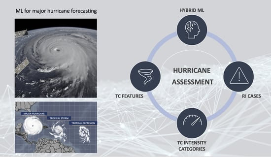
1. Introduction
2. Materials and Methods
2.1. Data Products
2.2. Model Construction and Evaluation Metrics
3. Results and Discussion
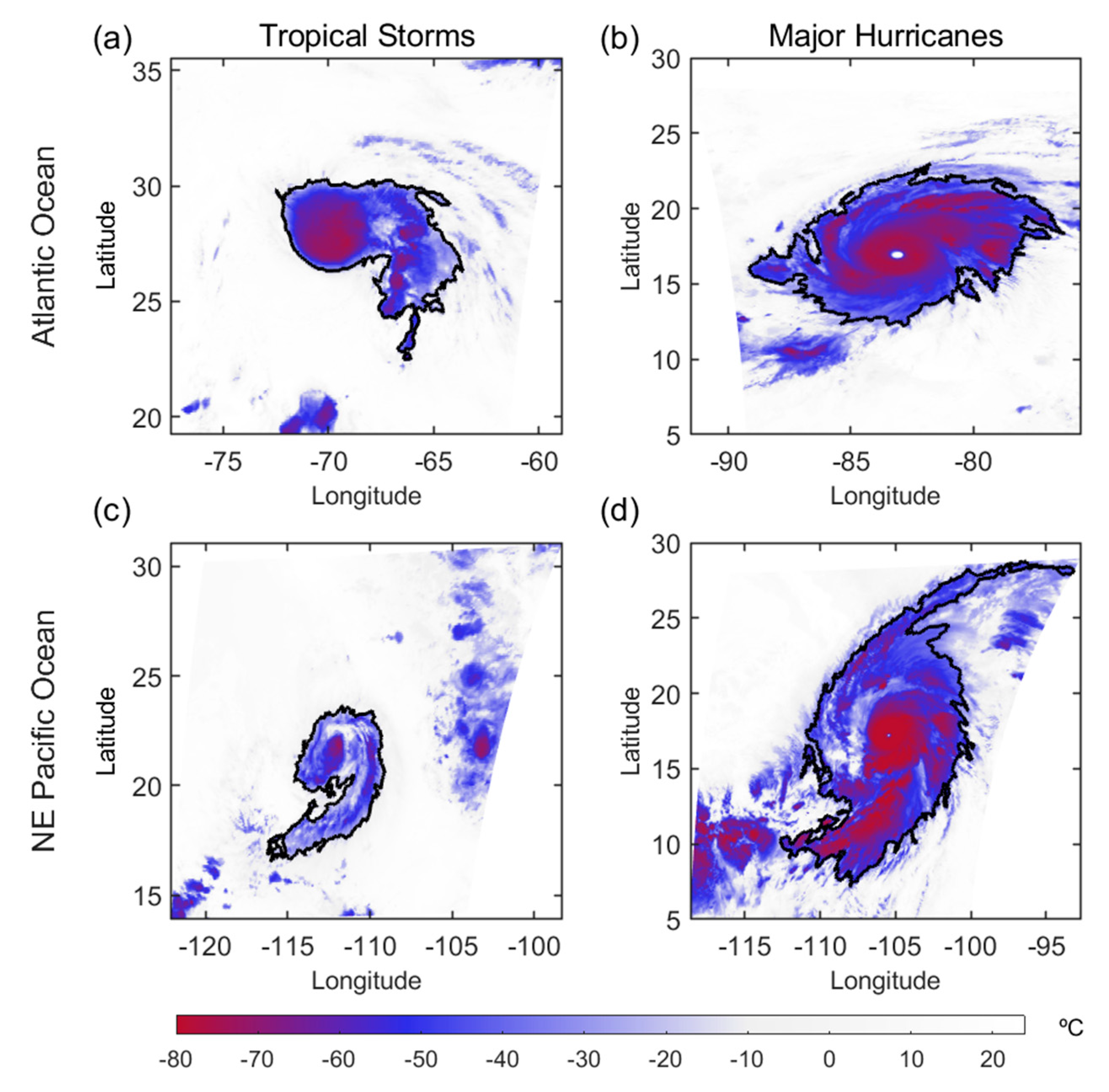
3.1. Optimal Combination of Key Structural Parameters Linked to Tropical Storm Intensification
3.2. Anticipating Major Hurricane Events
4. Summary and Conclusions
Author Contributions
Funding
Data Availability Statement
Acknowledgments
Conflicts of Interest
References
- Bhatia, K.T.; Vecchi, G.A.; Knutson, T.R.; Murakami, H.; Kossin, J.; Dixon, K.W.; Whitlock, C.E. Recent increases in tropical cyclone intensification rates. Nat. Commun. 2019, 10, 635. [Google Scholar] [CrossRef] [PubMed]
- Seneviratne, S.I.; Zhang, X.; Adnan, M.; Badi, W.; Dereczynski, C.; Di Luca, A.; Ghosh, S.; Iskandar, I.; Kossin, J.; Lewis, S.; et al. Weather and Climate Extreme Events in a Changing Climate. In Climate Change 2021: The Physical Science Basis. Contribution of Working Group I to the Sixth Assessment Report of the Intergovernmental Panel on Climate Change; Masson-Delmotte, V., Zhai, P., Pirani, A., Connors, S.L., Péan, C., Berger, S., Caud, N., Chen, Y., Goldfarb, L., Gomis, M.I., et al., Eds.; Cambridge University Press: Cambridge, UK; New York, NY, USA, 2021; pp. 1513–1766. Available online: https://www.ipcc.ch/report/ar6/wg1/downloads/report/IPCC_AR6_WGI_Chapter11.pdf (accessed on 16 November 2022).
- Knutson, T.; Camargo, S.J.; Chan, J.C.L.; Emanuel, K.; Ho, C.-H.; Kossin, J.; Mohapatra, M.; Satoh, M.; Sugi, M.; Walsh, K.; et al. Tropical Cyclones and Climate Change Assessment: Part I: Detection and Attribution. Bull. Amer. Meteor. Soc. 2019, 100, 1987–2007. [Google Scholar] [CrossRef]
- Reed, K.A.; Stansfield, A.M.; Wehner, M.F.; Zarzycki, C.M. Forecasted attribution of the human influence on Hurricane Florence. Sci. Adv. 2020, 6, eaaw9253. [Google Scholar] [CrossRef]
- Landsea, C.W. Comments on “Monitoring and Understanding Trends in Extreme Storms: State of Knowledge”. Bull. Am. Meteorol. Soc. 2015, 96, 1175–1176. [Google Scholar] [CrossRef]
- Alley, R.B.; Emanuel, K.A.; Zhang, F. Advances in weather prediction. Science 2019, 363, 342–344. [Google Scholar] [CrossRef] [PubMed]
- Coch, N.K. Inland damage from hurricanes. J. Coast. Res. 2020, 36, 1093–1105. [Google Scholar] [CrossRef]
- Tallapragada, V.; Bernardet, L.; Biswas, M.K.; Gopalakrishnan, S.; Kwon, Y.; Liu, Q.; Zhang, X. Hurricane Weather Research and Forecasting (HWRF) Model: 2013 Scientific Documentation; Developmental Testbed Center: Boulder, CO, USA, 2014. Available online: http://www.emc.ncep.noaa.gov/gc_wmb/vxt/pubs/HWRFScientificDocumentation2013.pdf (accessed on 16 November 2022).
- Biswas, M.K.; Bernardet, L.; Abarca, S.; Ginis, I.; Grell, E.; Kalina, E.; Kwon, Y.; Liu, B.; Liu, Q.; Marchok, T.; et al. 2017: Hurricane Weather Research and Forecasting (HWRF) Model: 2017 Scientific Documentation. In NCAR Technical Note NCAR/TN-544+STR; Developmental Testbed Center: Boulder, CO, USA, 2018. [Google Scholar] [CrossRef]
- Kieu, C.; Keshavamurthy, K.; Tallapragada, V.; Gopalakrishnan, S.; Trahan, S. On the growth of intensity forecast errors in the operational hurricane weather research and forecasting (HWRF) model. Q J R Meteorol. Soc. 2018, 144, 1803–1819. [Google Scholar] [CrossRef]
- Lee, C.Y.; Tippett, M.K.; Camargo, S.J.; Sobel, A.H. Probabilistic Multiple Linear Regression Modeling for Tropical Cyclone Intensity. Mon. Weather Rev. 2015, 143, 933–954. [Google Scholar] [CrossRef]
- DeMaria, M.; Mainelli, M.; Shay, L.K.; Knaff, J.A.; Kaplan, J. Further improvements to the Statistical Hurricane Intensity Prediction Scheme (SHIPS). Weather Forecast. 2005, 20, 531–543. [Google Scholar] [CrossRef]
- Xu, W.; Balaguru, K.; August, A.; Lalo, N.; Hodas, N.; DeMaria, M.; Judi, D. Deep Learning Experiments for Tropical Cyclone Intensity Forecasts. Weather Forecast. 2021, 36, 1453–1470. [Google Scholar] [CrossRef]
- DeMaria, M.; Franklin, J.L.; Onderlinde, M.J.; Kaplan, J. Operational Forecasting of Tropical Cyclone Rapid Intensification at the National Hurricane Center. Atmosphere 2021, 12, 683. [Google Scholar] [CrossRef]
- Nystrom, R.G.; Zhang, F. Practical Uncertainties in the Limited Predictability of the Record-Breaking Intensification of Hurricane Patricia (2015). Mon. Weather Rev. 2019, 147, 3535–3556. [Google Scholar] [CrossRef]
- Cangialosi, J.P.; Blake, E.; DeMaria, M.; Penny, A.; Latto, A.; Rappaport, E.; Tallapragada, V. Recent Progress in Tropical Cyclone Intensity Forecasting at the National Hurricane Center. Weather 2020, 35, 1913–1922. [Google Scholar] [CrossRef]
- Lee, C.Y.; Tippett, M.; Sobel, A.; Camargo, S.J. Rapid intensification and the bimodal distribution of tropical cyclone intensity. Nat. Commun. 2016, 7, 10625. [Google Scholar] [CrossRef]
- Chen, R.; Zhang, W.; Wang, X. Machine Learning in Tropical Cyclone Forecast Modeling: A Review. Atmosphere 2020, 11, 676. [Google Scholar] [CrossRef]
- Pradhan, R.; Aygun, R.; Maskey, M.; Ramachandran, R.; Cecil, D. Tropical cyclone intensity estimation using a deep convolutional neural network. IEEE Trans. Image Process. 2018, 27, 692–702. [Google Scholar] [CrossRef]
- Lee, J.; Im, J.; Cha, D.-H.; Park, H.; Sim, S. Tropical Cyclone Intensity Estimation Using Multi-Dimensional Convolutional Neural Networks from Geostationary Satellite Data. Remote Sens. 2020, 12, 108. [Google Scholar] [CrossRef]
- Maskey, M.; Ramachandran, R.; Ramasubramanian, M.; Gurung, I.; Freitag, B.; Kaulfus, A.; Bollinger, D.; Cecil, D.J.; Miller, J. Deepti: Deep-Learning-Based Tropical Cyclone Intensity Estimation System. IEEE J. Sel. Top. Appl. Earth Obs. Remote Sens. 2020, 13, 4271–4281. [Google Scholar] [CrossRef]
- Chen, R.; Wang, X.; Zhang, W.; Zhu, X.; Li, A.; Yang, C. A hybrid CNN-LSTM model for typhoon formation forecasting. Geoinformatica 2019, 23, 375–396. [Google Scholar] [CrossRef]
- Kim, S.-H.; Moon, I.-J.; Won, S.-H.; Kang, H.-W.; Kang, S.K. Decision-Tree-Based Classification of Lifetime Maximum Intensity of Tropical Cyclones in the Tropical Western North Pacific. Atmosphere 2021, 12, 802. [Google Scholar] [CrossRef]
- Auret, L.; Aldrich, C. Interpretation of nonlinear relationships between process variables by use of random forests. Miner. Eng. 2012, 35, 27–42. [Google Scholar] [CrossRef]
- Belgiu, M.; Drăguţ, L. Random Forest in remote sensing: A review of applications and future directions. ISPRS J. Photogramm. Remote Sens. 2016, 114, 24–31. [Google Scholar] [CrossRef]
- Breiman, L. Random Forests. Mach. Learn. 2001, 45, 5–32. [Google Scholar] [CrossRef]
- Carrasco, C.A.; Landsea, C. W.; Lin, Y.-L. The influence of tropical cyclone size on its intensification. Weather Forecast. 2014, 29, 582–590. [Google Scholar] [CrossRef]
- Bender, M.A.; Marchok, T.P.; Sampson, C.R.; Knaff, J.A.; Morin, M.J. Impact of Storm Size on Prediction of Storm Track and Intensity Using the 2016 Operational GFDL Hurricane Model. Weather Forecast. 2017, 32, 1491–1508. [Google Scholar] [CrossRef]
- Chen, B.-F.; Chen, B.; Lin, H.-T.; Elsberry, R.L. Estimating tropical cyclone intensity by satellite imagery utilizing convolutional neural networks. Weather Forecast. 2019, 34, 447–465. [Google Scholar] [CrossRef]
- Zehr, R.M. Environmental Vertical Wind Shear with Hurricane Bertha (1996). Weather. Forecast. 2003, 18, 345–356. [Google Scholar] [CrossRef]
- Wu, L.; Tian, W.; Liu, Q.; Cao, J.; Knaff, J.A. Implications of the observed relationship between tropical cyclone size and intensity over the western North Pacific. J. Clim. 2015, 28, 9501–9506. [Google Scholar] [CrossRef]
- Guo, X.; Tan, Z.-M. Tropical cyclone fullness: A new concept for interpreting storm intensity. Geophys. Res. Lett. 2017, 44, 4324–4331. [Google Scholar] [CrossRef]
- Xu, J.; Wang, Y. Dependence of Tropical Cyclone Intensification Rate on Sea Surface Temperature, Storm Intensity, and Size in the Western North Pacific. Weather Forecast. 2018, 33, 523–537. [Google Scholar] [CrossRef]
- Song, J.; Duan, Y.; Klotzbach, P.J. Revisiting the relationship between tropical cyclone size and intensity over the western North Pacific. Geophys. Res. Lett. 2020, 47, e2020GL088217. [Google Scholar] [CrossRef]
- Chen, K.; Chen, G.; Rao, C.; Wang, Z. Relationship of tropical cyclone size change rate with size and intensity over the western North Pacific. Atmos. Ocean. Sci. Lett. 2021, 14, 100040. [Google Scholar] [CrossRef]
- Knaff, J.A.; Longmore, S.P.; Molenear, D.A. An Objective Satellite-Based Tropical Cyclone Size Climatology. J. Clim. 2014, 27, 455–476. [Google Scholar] [CrossRef]
- Asif, A.; Dawood, M.; Jan, B.; Khurshid, J.; DeMaria, M.; Minhas, F.A.A. PHURIE: Hurricane intensity estimation from infrared satellite imagery using machine learning. Neural Comput. Appl. 2020, 32, 4821–4834. [Google Scholar] [CrossRef]
- Knapp, K.R.; Kruk, M.C.; Levinson, D.H.; Diamond, H.J.; Neumann, C.J. The International Best Track Archive for Climate Stewardship (IBTrACS): Unifying tropical cyclone best track data. Bull. Amer. Meteor. Soc. 2010, 91, 363–376. [Google Scholar] [CrossRef]
- Yang, C.; Liu, Z.; Gao, F.; Childs, P.P.; Min, J. Impact of assimilating GOES imager clear-sky radiance with a rapid refresh assimilation system for convection-permitting forecast over Mexico. J. Geophys. Res. Atmos. 2017, 122, 5472–5490. [Google Scholar] [CrossRef]
- Product Definition and User’s Guide (PUG), Volume 5: Level 2+ Products, DCN 7035538, GOES-R/Code 416 (NOAA, 2019). Available online: https://www.goes-r.gov/products/docs/PUG-L2+-vol5.pdf (accessed on 16 November 2022).
- James, G.; Witten, D.; Hastie, T.; Tibshirami, R. Resampling Methods. In An Introduction to Statistical Learning, 2nd ed.; Springer Texts in Statistics: New York, NY, USA, 2013; p. 181. Available online: https://link.springer.com/content/pdf/10.1007/978-1-0716-1418-1_5.pdf (accessed on 16 November 2022).
- Landis, J.; Koch, G. The measurement of observer agreement for categorical data. Biometrics 1977, 33, 159–174. [Google Scholar] [CrossRef]
- Pu, Z.; Li, X.; Zipser, E.J. Diagnosis of the Initial and Forecast Errors in the Numerical Simulation of the Rapid Intensification of Hurricane Emily (2005). Weather Forecast. 2009, 24, 1236–1251. [Google Scholar] [CrossRef][Green Version]
- Gupta, U.; Jitkajornwanich, K.; Elmasri, R.; Fegaras, L. Adapting K-means clustering to identify spatial patterns in storms. In Proceedings of the 2016 IEEE International Conference on Big Data (Big Data), Washington, DC, USA, 5–8 December 2016; pp. 2646–2654. [Google Scholar]
- Wang, Y.; Rosowsky, D. Joint distribution model for prediction of hurricane wind speed and size. Struct. Saf. 2012, 35, 40–51. [Google Scholar] [CrossRef]
- Drake, L. Scientific prerequisites to comprehension of the tropical cyclone forecast, intensity, track, and size. Weather Forecast. 2012, 27, 462–472. [Google Scholar] [CrossRef]
- Chan, K.T.F.; Chan, J.C.L. Global climatology of tropical cyclone size as inferred from QuikSCAT data. Int. J. Climatol. 2015, 35, 4843–4848. [Google Scholar] [CrossRef]
- Dolling, K.; Ritchie, E.; Tyo, J. The use of the deviation angle variance technique on geostationary satellite imagery to estimate tropical cyclone size parameters. Weather Forecast. 2016, 31, 1625–1642. [Google Scholar] [CrossRef]
- Zhang, G.; Perrie, W.; Zhang, B.; Yang, J.; He, Y. Monitoring of tropical cyclone structures in ten years of RADARSAT-2 SAR images. Remote Sens. Environ. 2020, 236, 111449. [Google Scholar] [CrossRef]
- Wei, Y.; Yang, R. An Advanced Artificial Intelligence System for Investigating Tropical Cyclone Rapid Intensification with the SHIPS Database. Atmosphere 2021, 12, 484. [Google Scholar] [CrossRef]
- Jiang, J.; Huang, Z.G.; Grebogi, C.; Lai, Y.C. Predicting extreme events from data using deep machine learning: When and where. Phys. Rev. Res. 2020, 4, 023028. [Google Scholar] [CrossRef]
- Chawla, N.V. C4.5 and Imbalanced Datasets: Investigating the Effect of Sampling Method Probabilistic Estimate and Decision tree Structure. In Proceedings of the International Conference on Machine Learning, Workshop on Learning from Imbalanced Datasets, Washington, DC, USA, 21 August 2003; pp. 1–8. Available online: https://www3.nd.edu/~dial/publications/chawla2003c45.pdf (accessed on 16 November 2022).
- Gu, Y.; Wu, L.; Zhan, R. Climatology of developing and nondeveloping disturbances for tropical cyclone genesis over the western North Pacific. Terr. Atmos. Ocean. Sci. 2022, 33, 13. [Google Scholar] [CrossRef]
- Kishtawal, C.M.; Jaiswal, N.; Singh, R.; Niyogi, D. Tropical cyclone intensification trends during satellite era (1986–2010). Geophys. Res. Lett. 2012, 39, L10810. [Google Scholar] [CrossRef]


| Time (h) | 6 | 12 | 18 | 24 | 30 | 36 | 42 | 48 | 54 |
|---|---|---|---|---|---|---|---|---|---|
| # Samples | 122 | 128 | 128 | 134 | 126 | 114 | 118 | 100 | 80 |
| # Trees | 29.80 | 34.20 | 35.00 | 27.60 | 22.20 | 34.20 | 12.60 | 54.00 | 28.60 |
| pMH (%) | 72.10 | 75.65 | 84.38 | 76.78 | 80.58 | 76.09 | 92.67 | 76.22 | 77.12 |
| k | 0.47 | 0.50 | 0.69 | 0.55 | 0.64 | 0.58 | 0.71 | 0.58 | 0.48 |
| Time (h) | 6 | 12 | 18 | 24 | 30 | 36 | 42 | 48 | 54 |
|---|---|---|---|---|---|---|---|---|---|
| # Samples | 188 | 190 | 192 | 192 | 182 | 170 | 148 | 136 | 106 |
| # Trees | 39.20 | 39.80 | 37.80 | 18.40 | 17.20 | 48.20 | 14.60 | 48.40 | 15.80 |
| pMH (%) | 66.78 | 70.55 | 67.72 | 74.55 | 72.31 | 79.79 | 77.88 | 70.54 | 81.79 |
| k | 0.34 | 0.40 | 0.35 | 0.49 | 0.46 | 0.57 | 0.59 | 0.40 | 0.53 |
| Time (h) | 6 | 12 | 18 | 24 | 30 | 36 | 42 | 48 | 54 |
|---|---|---|---|---|---|---|---|---|---|
| # Samples | 310 | 318 | 320 | 326 | 308 | 284 | 276 | 236 | 186 |
| # Trees | 32.60 | 36.40 | 46.20 | 47.00 | 71.80 | 36.00 | 22.40 | 51.20 | 51.00 |
| pMH (%) | 69.12 | 70.94 | 72.54 | 73.71 | 71.94 | 71.01 | 77.49 | 74.58 | 73.14 |
| k | 0.40 | 0.42 | 0.46 | 0.49 | 0.46 | 0.45 | 0.57 | 0.47 | 0.44 |
Disclaimer/Publisher’s Note: The statements, opinions and data contained in all publications are solely those of the individual author(s) and contributor(s) and not of MDPI and/or the editor(s). MDPI and/or the editor(s) disclaim responsibility for any injury to people or property resulting from any ideas, methods, instructions or products referred to in the content. |
© 2022 by the authors. Licensee MDPI, Basel, Switzerland. This article is an open access article distributed under the terms and conditions of the Creative Commons Attribution (CC BY) license (https://creativecommons.org/licenses/by/4.0/).
Share and Cite
Martinez-Amaya, J.; Radin, C.; Nieves, V. Advanced Machine Learning Methods for Major Hurricane Forecasting. Remote Sens. 2023, 15, 119. https://doi.org/10.3390/rs15010119
Martinez-Amaya J, Radin C, Nieves V. Advanced Machine Learning Methods for Major Hurricane Forecasting. Remote Sensing. 2023; 15(1):119. https://doi.org/10.3390/rs15010119
Chicago/Turabian StyleMartinez-Amaya, Javier, Cristina Radin, and Veronica Nieves. 2023. "Advanced Machine Learning Methods for Major Hurricane Forecasting" Remote Sensing 15, no. 1: 119. https://doi.org/10.3390/rs15010119
APA StyleMartinez-Amaya, J., Radin, C., & Nieves, V. (2023). Advanced Machine Learning Methods for Major Hurricane Forecasting. Remote Sensing, 15(1), 119. https://doi.org/10.3390/rs15010119