1. Introduction
The outbreak of epidemic disease in the Indian Ocean during the 19th century correlated with increased migration and improvements in steamship technology, forcing colonial governments to invest substantial resources in building and managing quarantine stations. These institutions were often set up in relatively isolated locations, especially uninhabited islets. Ships suspected of transporting infected commodities or sick people were then diverted to these islets, preventing them from docking at the regular ports. A resilient construction design of such facilities, originating in the Mediterranean world in response to plague epidemics during the medieval period [
1], were adapted to a tropical environment and emerging infectious diseases. Modifications to the Mediterranean model were conditioned by two main factors: the specific disease in question, e.g., malaria, smallpox, and cholera, whose etiology and transmission was unknown at the time, and by the need to accommodate many people of various social classes and geographical origin (crew, travelers, and migrant workers) in a limited space, often for a considerable time.
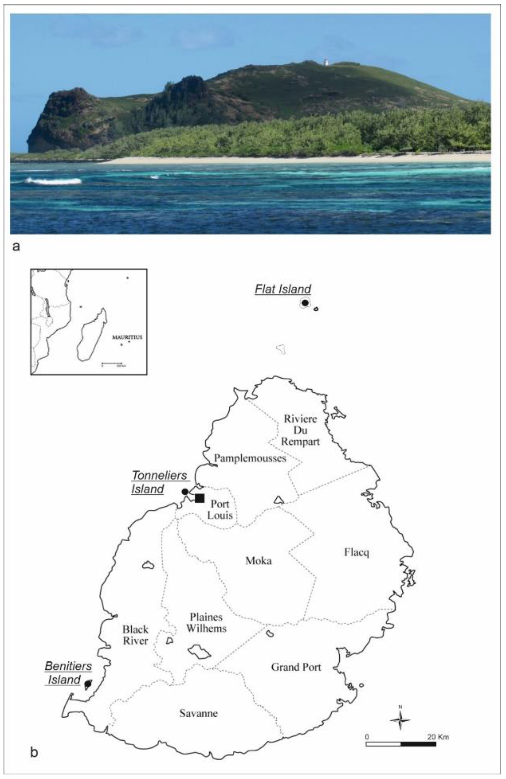
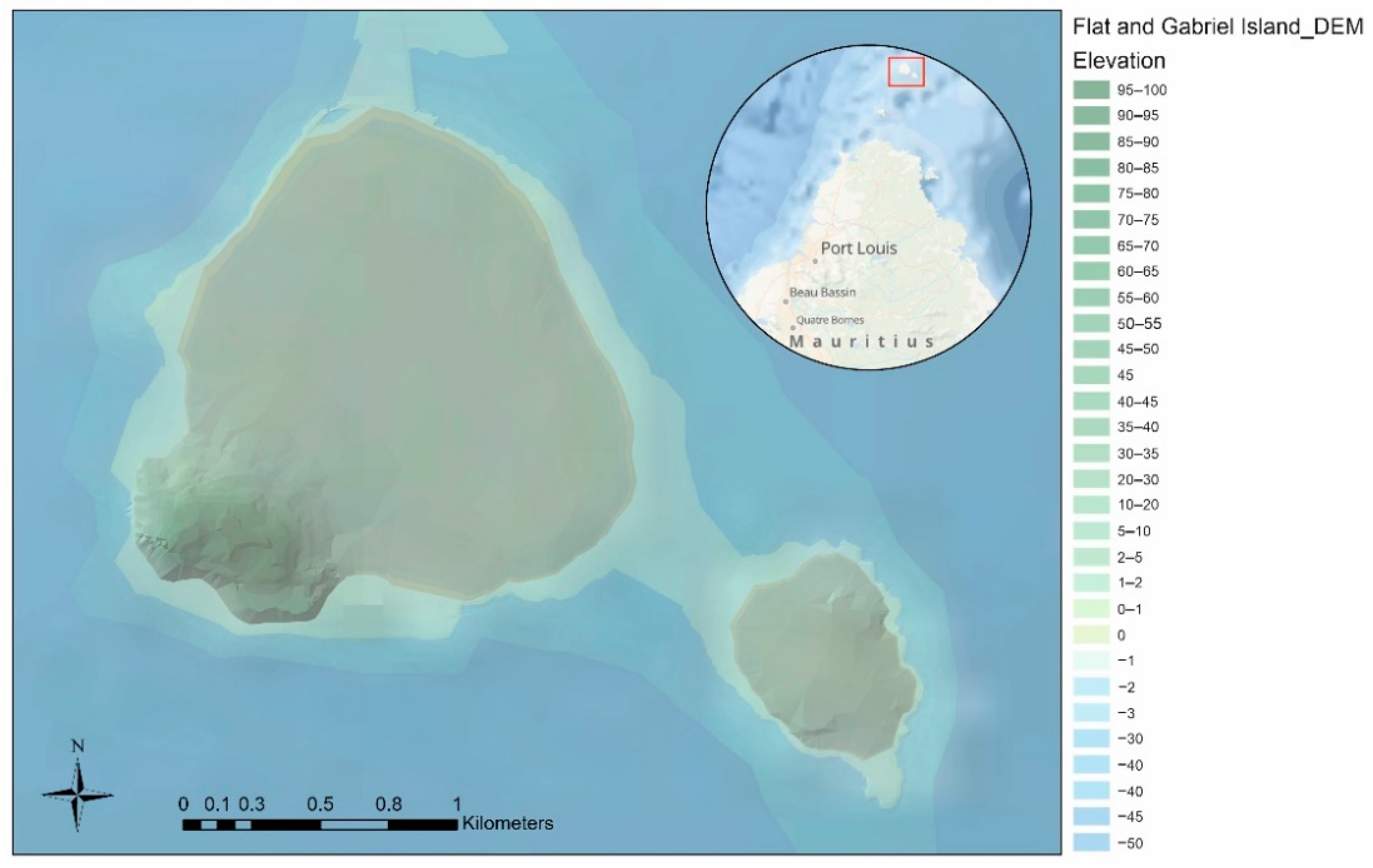
Flat Island is an exceptionally well-preserved quarantine station in the Indian Ocean, situated 12 km from the northern coast of Mauritius and used intensively during the second half of the 19th century (
Figure 1a). Within a few years, from circa 1856, this uninhabited islet was drastically transformed. Environmental changes were wrought as a consequence of introducing invasive animals and plants, ultimately creating an anthropic landscape with a built infrastructure. Flat Island quarantine station has significant heritage value as it has not been reused or repurposed since being abandoned after 1926. Comparable sites have been altered due to extensive use or conversion, such as leper colonies or military bases, resulting in a radical transformation of the original built landscape [
2,
3]. The sudden abandonment of Flat Island at the onset of the 20th century left the station as an indelible material imprint, a witness to important structural facets of colonial health and disease management, as well as a unique example of cultural heritage.
The main aim of this research was to identify and study the built responses to health requirements in this specific region and historical moment. Examining the health-related rationale behind the built environment documented on Flat Island, this article presents the standing architecture and the functional configuration of the quarantine landscape, the design of which was clearly influenced by the dual forces of the prevailing medical theory and the exigent epidemic. The main activities involved in this study were archival research in the National Archives of Mauritius (NAM), followed by archaeological surveys and mapping of the standing architecture, which resulted in the collection of copious historical and archaeological data. The standard landscape archaeology and spatial methods, such as drone mapping, photogrammetry, GPS, and total station surveys, were combined with orthorectification and 3D modelling, returning detailed documentation of the built environment. Furthermore, the assessment and comparison of the original architectural drawings from the 1850s with the constructed buildings, as well as repairs and modifications during their use, grants an understanding of how construction plans were adjusted for emerging practical needs. Through specific improvements, such as the use of concrete instead of wood and the implementation of a water piping system, it is possible to follow the spatial and social negotiations in the long-term use of the site. Fresh water was considered an essential element: the major structural restoration and facility implementations aimed to secure healthy conditions and sustainability requirements through time. The construction of latrines for women in the quarantine camps after 1877 responded to specific social needs, possibly determined by new demands from a growing migrant female population. Flat Island’s spatial and functional organization reflects both the medical beliefs of the time and the social biases driven by the colonial elite, affecting the human behavior of migrants. Few colonial officers dictated regulations on which large numbers of quarantined indentured laborers, mostly from Southeast Asia, had to comply. The result of all these actions can be summarized in the concept of “healthscaping”, defined as “the physical, social, legal, administrative and political process of regulating and managing the built and natural environment to promote wellbeing” [
4] (p. 396). In this article, we focus on the physical and social processes enacted in the founding and management of the station to consider the gap between the theoretical claim and the practical output realized by British colonizers in promoting public health practices. Although general rules of preventive healthcare were well established and detailed by written sources, their material implementation in the built landscape was more varied, based on social discrimination between Europeans and immigrants.
1.1. Historical Background
Modern ideas of quarantine are linked to globalization. Although the practice of isolating miasmatic or polluted matter far predated the outbreak of epidemic diseases, especially plague during the Middle Ages; the earliest quarantine practices were developed during this time. Believing that miasma (“bad air”) caused disease did establish the connection between location and transmission of diseases [
5]. Quarantine measures were first introduced in 1377 in the Republic of Ragusa, Dalmatia (present-day Dubrovnik in Croatia), with a thirty-day isolation period for all incoming ships, suspected of carrying disease on board. The screening and disinfection practices were initially implemented by fumigating goods and only secondarily by isolating animals and people. In Venice, the “trentino” was extended to “quarantino” (quaranta giorni, i.e., forty days) in the late 1400s, imposed on ships and their crews before they could dock in the city [
6] (pp. 99–110), [
7] (p. 176). Over the centuries, the practice of quarantine spread all around Europe and farther, in the colonial worlds becoming a recurrent matter of political and economic debate, as well as a source of abuse, which can still be observed in current times [
5,
8,
9,
10,
11].
The quarantine system was operational in the colonies in the Indian Ocean from the mid-19th century onwards. After the abolition of slavery in the 1830s, a mass of indentured laborers replaced the enslaved people [
12]. Since this, it was encouraged mainly by the Indian government, as the vast majority of the indentured diaspora originated from India.
In the Mascarene islands, between the 18th and the 19th centuries, three main diseases required the use of quarantine: smallpox, cholera, and malaria. Their etiology and incubation period were unknown to contemporaneous physicians. Smallpox was the primary cause of epidemics in enslaved communities during the 18th century, but a coherent system of quarantine stations was never established; instead, temporary isolation or so-called maritime quarantine was applied to incoming ships. These were left to anchor outside of the main port of Port Louis, particularly in Belle Buoy and Grand Riviere, farther south. In the 18th century, temporary stations, the first quarantine depots, were set up on the islands of Tonneliers near Port Louis, and Bénitiers in the south, and housed people in provisional shelters without any medical care (
Figure 1b). After the introduction and widespread use of the smallpox vaccine in the 19th century, cholera became the primary disease that mandated quarantine [
13] (pp. 94–116) and was closely associated with indentured laborers from India. Regulatory changes in health management, new locations, and policies for quarantine inspection and detention were a result of the escalating intercontinental labor diaspora. For many immigrants, especially those coming from Southeast Asia, a quarantine station became the first place of contact with their new home, so the quarantine system was converted from its original health-oriented role into a socially controlling system [
14] (pp. 3–5).
1.2. Study Area
In the second half of the 19th century the Mauritian colonial government used Flat and Gabriel islands, two neighboring islets 12 km off the north coast of Mauritius, to isolate disease-ridden indenture ships. In the beginning, these two stations were confinement sites, with temporary wooden shelters, rather than actual quarantine stations. Hence, the main difficulty for people forced into quarantine was not the risk of contagious disease but the certainty of inadequate living conditions. A case in point occurred on Gabriel Island in January 1856, when around 300 indentured immigrants died due to harsh conditions, exacerbated by the cholera epidemic [
15]. This human disaster sparked a temporary diplomatic dispute leading to the cessation of immigration and a demand from the Indian government for a permanent quarantine station on the mainland [
13] (pp. 142–157).
In the following years, under pressure from the Indian government, the Mauritian quarantine system was reorganized by setting up two permanent quarantine stations: one on Flat Island for cholera and another on the mainland, at Pointe aux Cannoniers, for all other diseases [
16] (pp. 140–143). Both stations included dormitories, hospitals, a morgue (called dead house), water cisterns, latrines, and a graveyard. Environmental factors were considered crucial in planning these institutions: the quarantine stations were positioned on the coast, with specific buildings constructed to help with disinfection and sanitization procedures. Particular attention was given to the orientation and ventilation of buildings, especially hospitals and infirmaries, since miasmas were considered to cause infectious diseases until the 1880s, when the emergence of germ theory marked a new understanding of disease etiology [
17].
2. Materials and Methods
The Mauritian Archaeology and Cultural Heritage (MACH) project group, initially based at the University of Cambridge, UK, and currently at Stanford University, USA, has been working on the cultural heritage of Mauritius since 2008. Our work on Flat Island began in 2014, with a setback in the last two years, due to the COVID-19 pandemic. Flat Island is located outside of the Mauritian reef, without any housing or infrastructure, and the natural setting with powerful underwater currents and strong winds limits access to the island to a few hours per day. The logistical complexity permitted us to stay on the island only up to two weeks per season. Therefore, from the beginning, extensive use of remote sensing methods was mandated by the practical difficulties in reaching the site and conducting fieldwork.
The team, initially composed of historians and archaeologists from the Aapravasi Ghat Trust Fund (AGTF) and Stanford University, was later expanded to include other colleagues from the National Parks and Conservation Services (NPCS). Finally, additional archaeologists specializing in landscape archaeology and geophysical surveys were involved in the fieldwork, along with undergraduate and PhD students.
Due to practical constraints imposed by the location, it was essential to choose techniques that were financially and technologically viable and relatively easy to implement. Following the initial site examinations and topographic surveys, a census of historical maps was made, incorporating georeferenced satellite and aerial images, all imported as different layers to a GIS platform. Thus, we produced a DEM of the island and a base map, subsequently enhanced with archaeological evidence.
2.1. Data Sources
Landscape archaeologists have long recognized the complementary role of historical maps, satellite imagery, and aerial photographs. The first step of our research focused on the collection of such materials.
Historical maps produced during the colonial period have acquired a prominent role within historical archaeology. Their main contribution is displaying complexly designed past landscapes, which are profoundly obscured in modern cartography [
18,
19]. The advance of trigonometrical surveying from the 1850s coincided with significant shifts in the production and dissemination of spatial knowledge of the colonial East Indies, Mauritius included [
20]. The topographical surveys performed by the British Empire allow scholars to benefit from maps of exceptional accuracy and precision. Fortunately, Flat Island was also mapped in detail and its small size facilitates accurate georeferencing of historical maps (see below paragraph 3). Indeed, the financial investment in the construction of the quarantine station involved the production of general and detailed plans, as well as the update of nautical charts for the steamships. Specifically, a digital reconstruction of our case study included historical maps preserved in the NMA, based on the land surveyor’s records of Flat Island before and after the establishment of the quarantine station. Comparing the designs and built structures helps track local adaptations to specific needs.
Available aerial photos range from 1949 to 1997; they can be accessed online at the National Collection of Aerial Photography (NCAP) website and consulted in the cartography section of the Ministry of Housing and Land Use Planning. Five photos were selected for this research because of their quality and relative lack of cloud coverage. Indeed, Mauritius is well monitored by earth observation satellites but with a focus on detecting the impact of seasonal cyclones, which regularly hit the island, climatic factors affecting shoreline change, and erosion risk assessment [
21], or for specific environmental disasters such as the recent MV Wakashio oil spill [
22]. However, Flat Island is often omitted because of its small size. For example, a rare cloud-free view of Mauritius was taken by Copernicus Sentinel-2 and is freely accessible on the Copernicus Program website [
23] as the image of the day (20 May 2021), but disappointingly Flat Island was not included. Among the numerous optical satellite imagery useful for monitoring cultural landscapes, we favored the Landsat satellite program due to global coverage and access to archived data since 1972 [
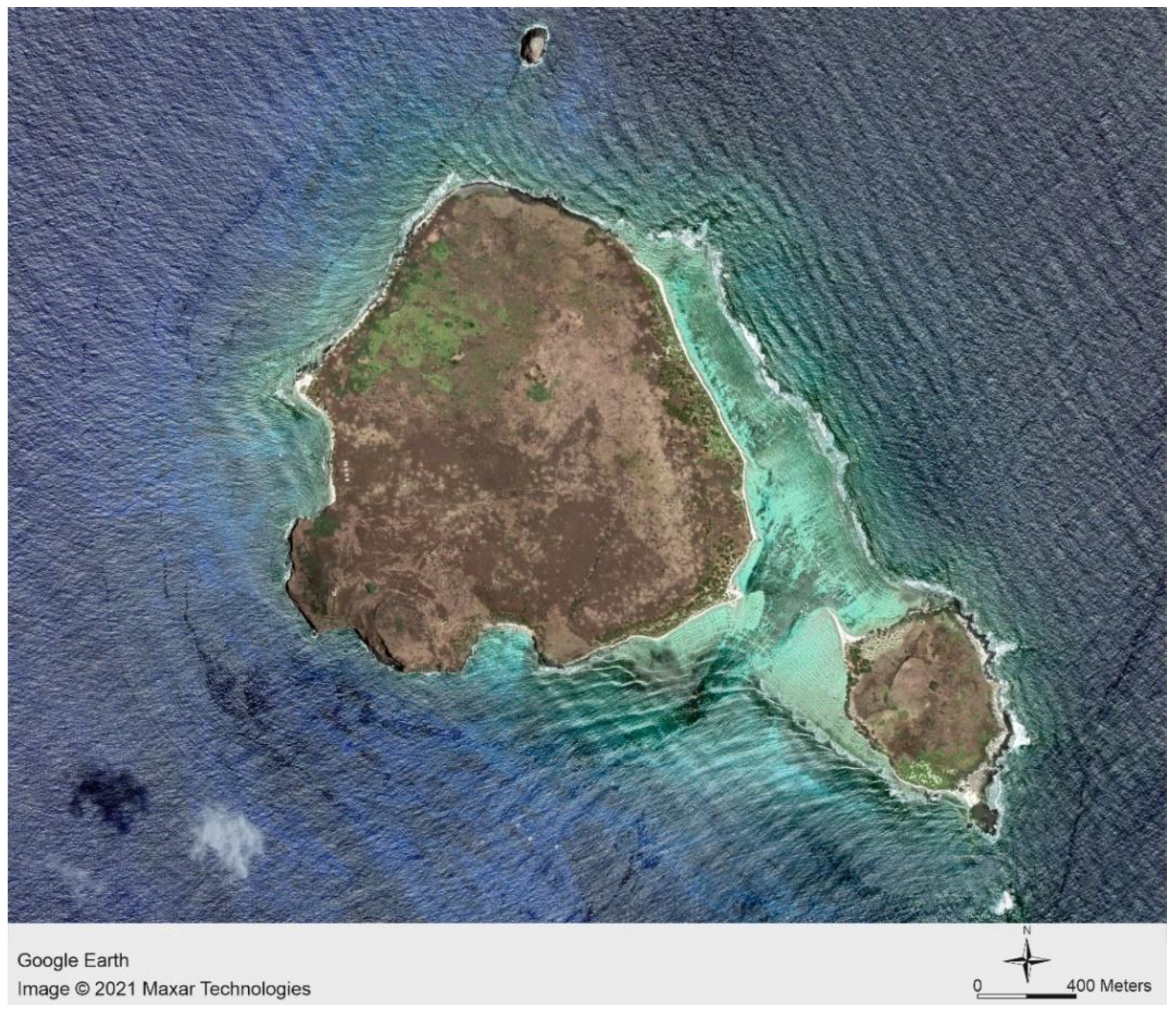
24]. We mostly used the Google Earth (GE) interface based on Maxar Technologies (Landsat and Copernicus), specifically to visualize and query digital images of Flat Island. This option offered the ideal balance between resolution and accessibility, including a dataset of historical satellite imagery available on this interface [
25]. This tool was helpful to visualize a short timelapse of the site, based on the two main phases of our research, i.e., pre and post fieldwork. GE provides high-resolution spatial-temporal variation (5–30 m as per definition) [
26]; however, coverage prior to 2009 is poor in terms of historical satellite imagery of adequate resolution. In addition, since the 1950s, increases in vegetation cover due to the island’s abandonment obscured the view, making them less useful in detecting archaeological features than traditional aerial frames from previous decades. Due to the lack of imagery with a resolution finer than 5 m, any observed spatial anomalies had to be verified on the ground; thus, a large amount of essential digital data was produced during the fieldwork.
In summary, the following original data were consulted, digitized, and generated:
Written historical data: most of the written documents useful for the research were acquired directly from NAM: (1) the historical maps of the island, (2) a considerable number of architectural plans of the quarantine architecture and engineering equipment (NAM,
Maps, D6-A57), and (3) documents about the establishment and management of the quarantine station in Flat Island in 1857 (NAM,
Secretariat Records, Inventory Group R—RA 1396), collated by the Civil Medical Department. The collaboration with the research professionals from AGTF was decisive in obtaining these materials, which are currently not freely available. The architectural plans, dated between 1855 and 1871, were crucial to identifying structures on-site and understanding the processes involved in establishing and implementing the quarantine station at Flat Island. The architectural plans predominantly represent project ideas: they often depict features that differ from what is found on the ground. Therefore, we reconsidered the still-standing buildings on the island and reassessed all previous interpretations to determine the chronological sequence of architectural phases and a detailed definition of the function of every single structure. The archival data also included the report of Dr. Small [
27], a military surgeon, who stayed in the quarantine station with the 2nd Battalion of the 13th Light Infantry during the malarial epidemics that oppressed Mauritius between 1867–69. Dr. Small’s report depicts the intangible features of the quarantine, such as the relation with the indentured workers in charge of the management of the institution or the treatment of the sick and dead. Similar information can be detected in the literary work by Le Clézio [
28]. Albeit a novel, the author did use his great-uncle’s personal experience to portray the fates of people confined to Flat Island in the late 19th century, not only the European travelers, but also the indenture community who worked on the island to ensure a minimum food supply for the quarantine.
Material culture: the survey of the uninhabited and overgrown island, conducted in collaboration with AGTF and NPCS, was our first step towards discovering and understanding the architectural remnants of the quarantine station. The tangible heritage consists of architectural, logistic, and landscape material remains of the quarantine, which include (1) basalt-built structures (buildings and water tanks), docking piers, roads and paths, camp enclosures, and cemeteries as well as (2) landscape transformations, for example orchards, gardens, and plantations, although these are much more difficult to recognize on the ground.
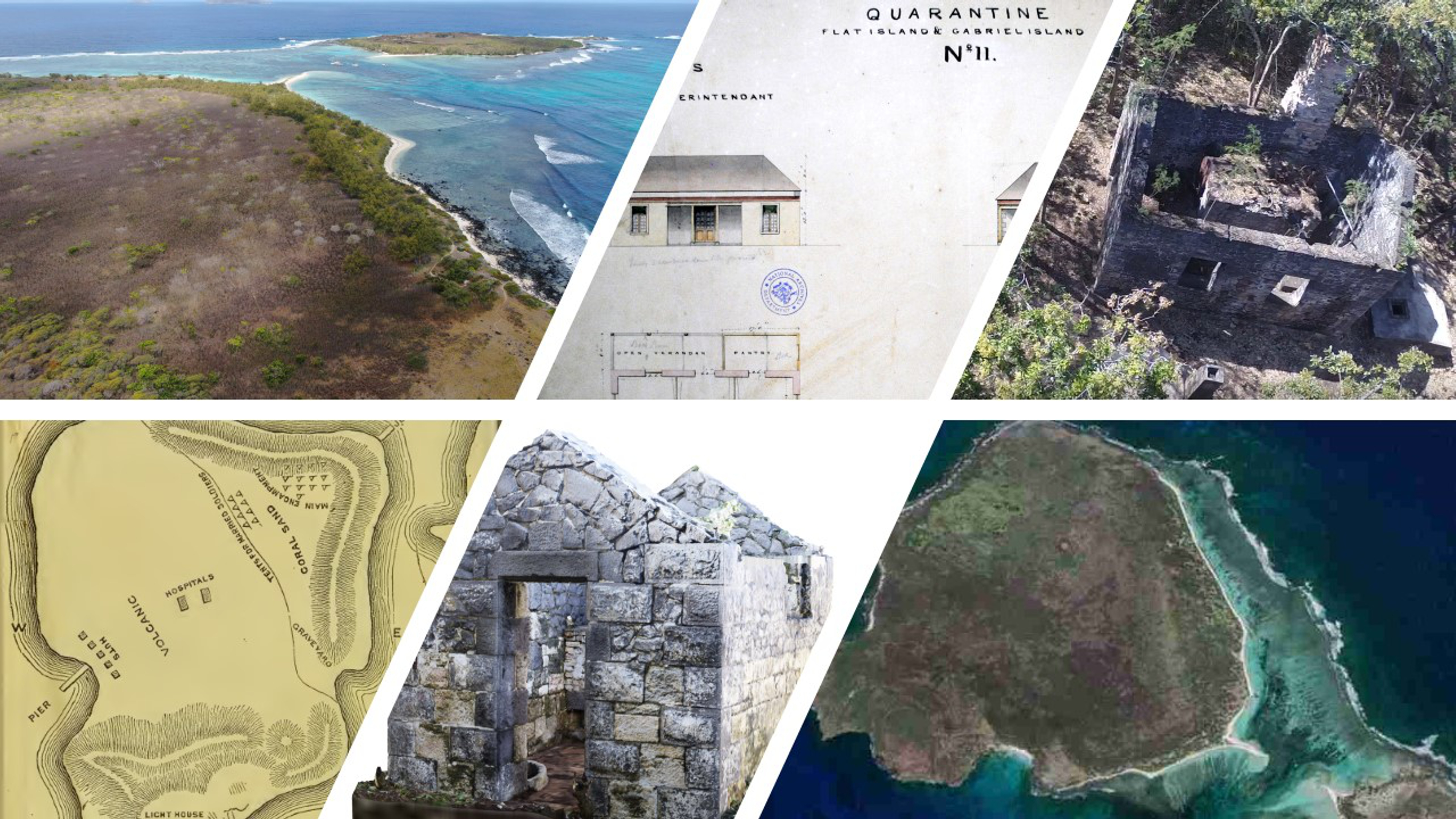
Digital data can be subdivided into (1) digitized: historical and modern maps and old aerial imagery and (2) digital born: satellite, aerial, and UAV imagery; DEM, RTK, and total station raw data; digital images of each building; and digital maps with located man-made features on GIS (
Figure 2).
2.2. Methodology
State-of-the-art methods of landscape archaeology applied on the entire island provided well-contextualized results.
Historical photos and maps were rectified based on the 2018 satellite image after several ground control points (GCPs) were identified and rectified accordingly. All rectified images are relative to each other and were processed using geometric corrections through UTM-WGS 84 projection and coordinate system in QGis 3.16 software (QGis, Hannover, Germany) (
Table 1).
Two different photoset acquisition methods, UAV and terrestrial photography, were used to produce high-resolution and ground-truthing images. The most suitable method was selected based on the specific environmental setting. The documentation of architectural features has traditionally been expensive and labor intensive, but the combination of traditional methods of archaeological documentation with innovative technologies provided by UAV proved to be the winning choice. It resulted not only in the acquisition of an unprecedented volume of high spatial resolution data to generate 3D digital surface models but was also cost-effective and time-efficient [
29].
We used a quadricopter DJI Phantom 4, and the data acquisition was performed by one sensor, the original DJI 4K camera recording video (mp4 files with 1920 × 1080 px resolution) and images in RGB (with 4000 × 3000 px resolution as RAW and JPEG). The integrated GPS autopilot system included position holding, altitude lock, and stable hovering to provide constant stability in flight. The UAV system was controlled by an autopilot system (the Android application Pix4Dcapture) which provided autonomous navigation based on the track (waypoints) programmed before the mission. The track was set at the height of 30 m above the ground, the speed was 3 km/h, and the distances between track lines were set at 12.5 m to achieve 80% side overlap, GSD 1.31 cm/px. The main drawback was the short battery flight time, which was only 20 min in the best weather conditions, so a careful selection of areas was mandatory. The three batteries used for a day’s work had to be used cautiously because the charging options were limited and slow. The sample areas covered by UAV imagery were the eastern jetty with the baggage store, the western jetty with quarantine camp 1, and the cemetery (around 200 × 200 m each). During the 2018 campaign, a DJI Spark with remote control was used for photogrammetry of the concrete platforms in Camp 1 (images in RGB with 4000 × 3000 px resolution as RAW and JPEG, see
Table 2, ID 12) to speed up documentation time of the cleared structures [
30,
31].
For the detailed documentation of standing structures (distinguished by the code “Str.” and progressive number; see
Supplementary Materials), we rendered models by terrestrial photography, using Structure from Motion (SfM) photogrammetry method, following good practice standards [
32]. We used a digital camera (Nikon D5300, 6000 × 4000 px resolution in JPEG), combined with RTK (South, S82 GNSS) and a total station (Leica TS06plus) to create photogrammetric processing and generate 3D models based on georeferenced control points to compute the horizontal and vertical accuracies [
33]. Ground control points (GCPs) were used to georeference and scale the models, increasing their accuracy. The model and the ground-truthing data usually had different reference coordinates, so they needed to be aligned [
34]. The prepared images from the camera were processed in the Agisoft PhotoScan Pro software (v. 1.4, now Metashape 1.7). We followed the software workflow—aligning photos, building dense cloud, building mesh, building texture, and building orthomosaic—to obtain a 3D model and orthomosaic (zenith and side) [
35]. Additional control points or markers were essential to join separate chunks of structure (exterior and interior elevations) and some manual adjustments were necessary to achieve the best results. Significant limitations stemmed from the difference in lighting conditions and the presence of vegetation and rubble, especially on the top of the walls. Generally, the small size and simplicity of the structures ensured that close-spaced images were successfully matched. However, radiometric variation in different images can result in matching failure and the need to repeat the photographic survey (for example for Str. 127-hospital and Str. 148-dead house) [
36].
For the research, the following workflow was adopted:
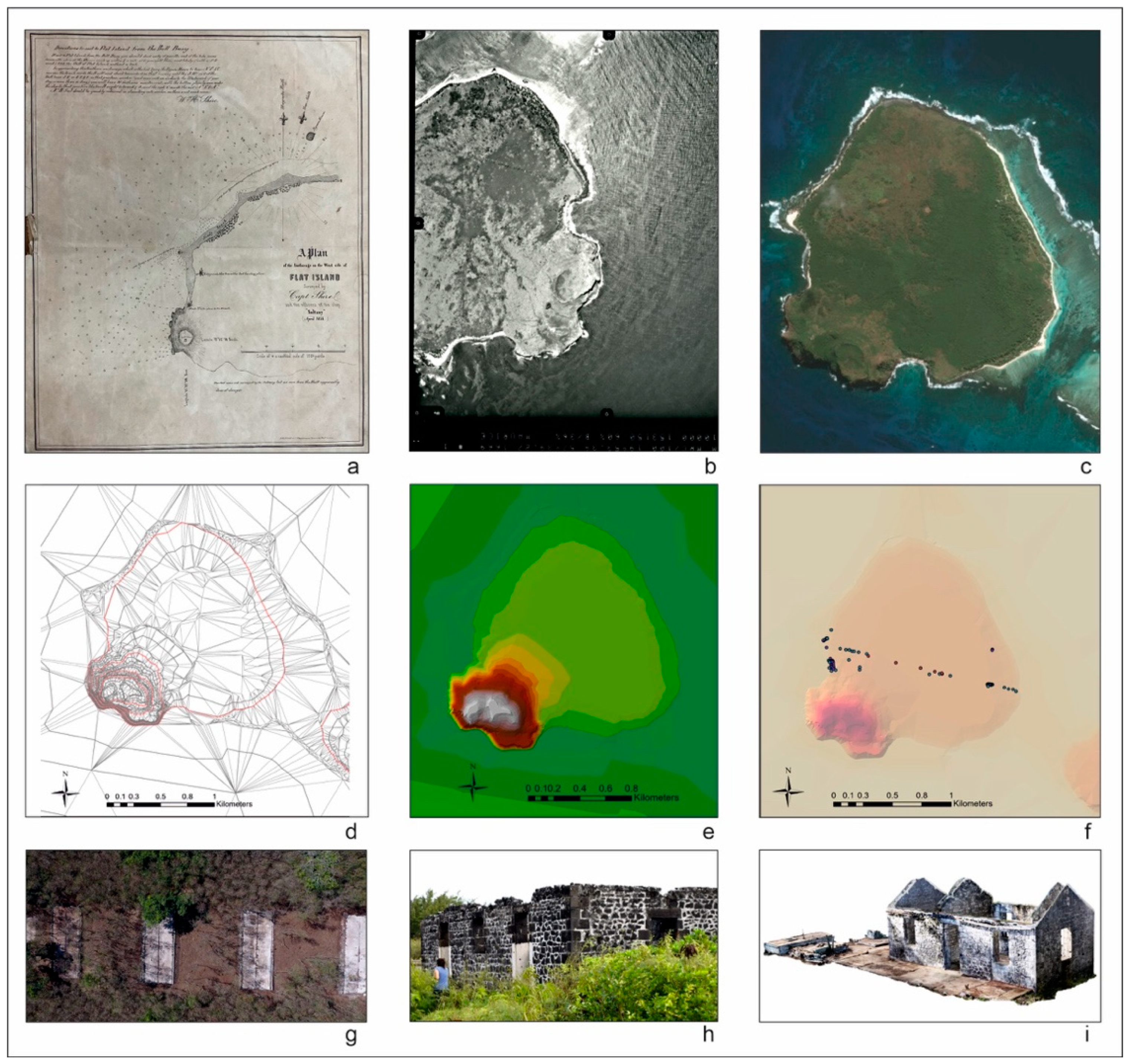
The preparation of the base map of the island: as a modern detailed map of the quarantine or the island itself does not exist, we sourced various archival maps of the built structures as well as of the islet and modern aerial and satellite images (
Figure 3).
The georeferencing of aerial images and historical maps to the maximum achievable detail to identify the elements presented and find the most accurate locations of the designed or constructed structures, roads, and paths. All the maps collected were processed in QGiS to create a comprehensive database of historical, archaeological, and geographical data about the islet. By overlapping these cartographic data, we could locate and identify most historical buildings, along with the connecting paths and logistic adjunct structures, as well as explore the stages of the development of this station.
The implementation of the Digital Elevation Model (DEM): based on aerial and satellite images and UAV recording of the island, we created the DEM of Flat Island to obtain a detailed orography of the site.
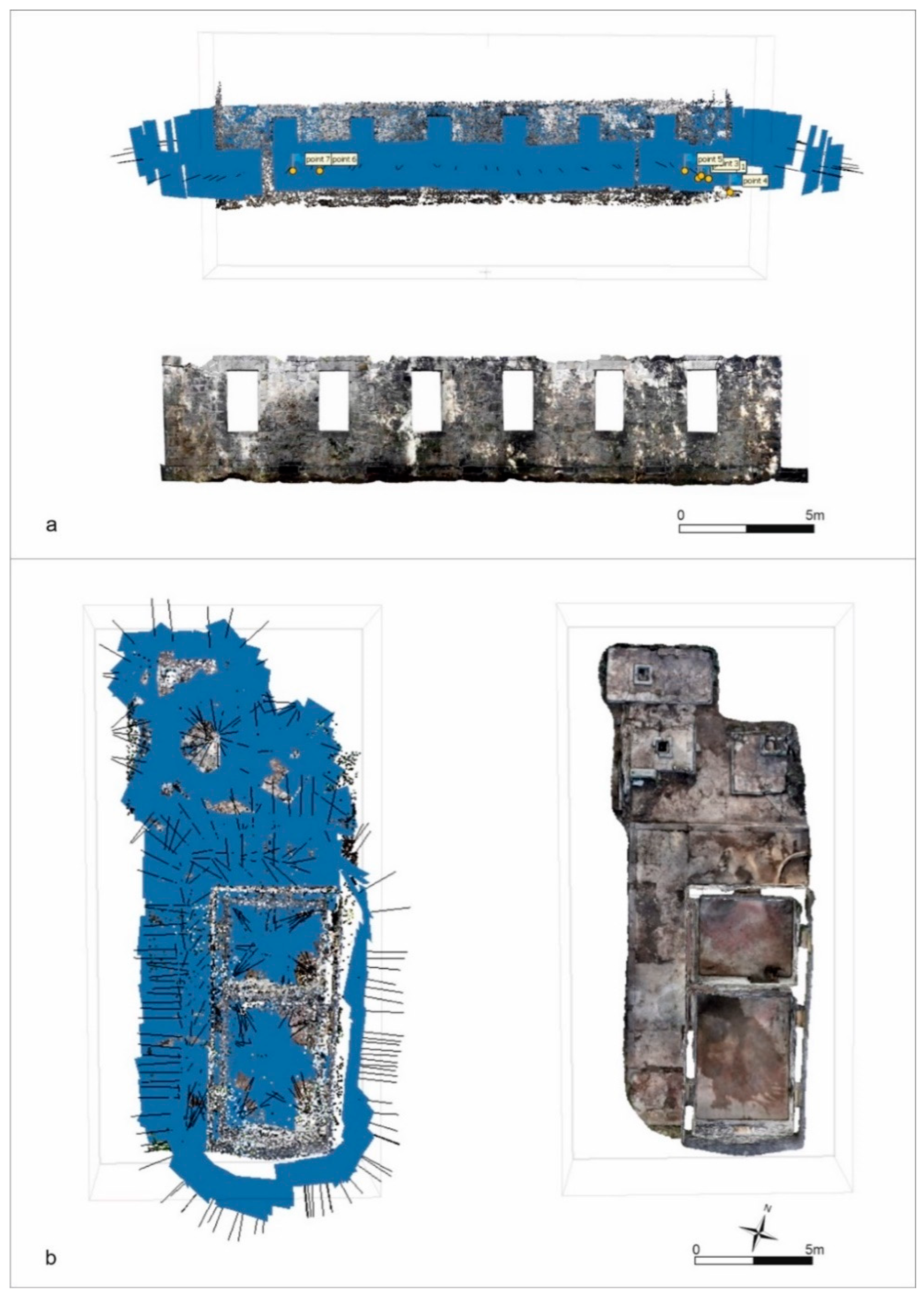
Archaeological reconnaissance: tracking the elements in the base map was accomplished by combining remote sensing techniques and fieldwork activities, survey and ground-truthing data included. The main two elements of methodical archaeological surveys that resulted in locating most of the preserved structures in the dense vegetation were the use of a handheld GPS (Garmin Oregon 700) and assistance from the NPCS team; both were instrumental in tracing the buildings and other features of the lost quarantine station. Camp 2 proved to be especially difficult to locate, and it took a few seasons to identify the poorly preserved material remains as the second segregation encampment in the quarantine quarter. With the fundamental knowledge about the quarantine structures, the emphasis turned to the individual features, respectively. Every building was cleared of vegetation and debris and documented in detail to create photogrammetric processing and generate 3D models (
Figure 4). Image-based modelling was preferred over laser scanners for its advantages as a complete, economical, and portable approach [
37]. In addition, 3D information was accurately recovered regardless of the size of the object and the clearance of a minimum amount of vegetation inside and around the buildings. Following the clearance of each adjoining area, a drone mapping was conducted to obtain the complete imagery of each feature, as well as for comprehensive survey documentation. In addition, a pilot geophysical survey was performed around structures in the south, in the vicinity of the east pier.
A database was developed with Filemaker Pro to create multiple listings of the features according to various sources with nonspatial tabular data included. The meticulous archival and ground-based documentation was prepared for every single man-made feature. This stage gradually increased with data recorded directly at the site via Filemaker Go. Each building or feature was classified as a polygon or point, labeled with a code (i.e., Str. 119) in the GIS platform related to an attribute table containing name, chronology, archival references, and other relevant information. The cataloging includes an exhaustive description with records of the exact topographic location, detailed photography, and linkage to the archival sources.
Overlaying preliminary maps with new detailed maps produced from a very comprehensive total station and RTK survey.
The final assessment each feature’s name, location, and function, accordingly.
3. Results
3.1. The Newly Generated Maps of Flat Island and the Quarantine Station
The modern topographic maps of Flat Island from the National Ministry of Housing and Land Use Planning do not show the historical buildings still present on the island. Being completely deserted since the 1930s, nature claimed the island back. Overgrown with endemic and imported vegetation [
38], only the lighthouse at the southwestern corner has remained easily recognizable as a historic building. Combining various elements from incomplete, fragmented, and low-information cartography with the contour lines on the fundamental 1978 map for all of Mauritius (Flat Island is included in Northern Islands, Sheet 14), we were able to create a DEM of the island with 1 m or 2 m accuracy (
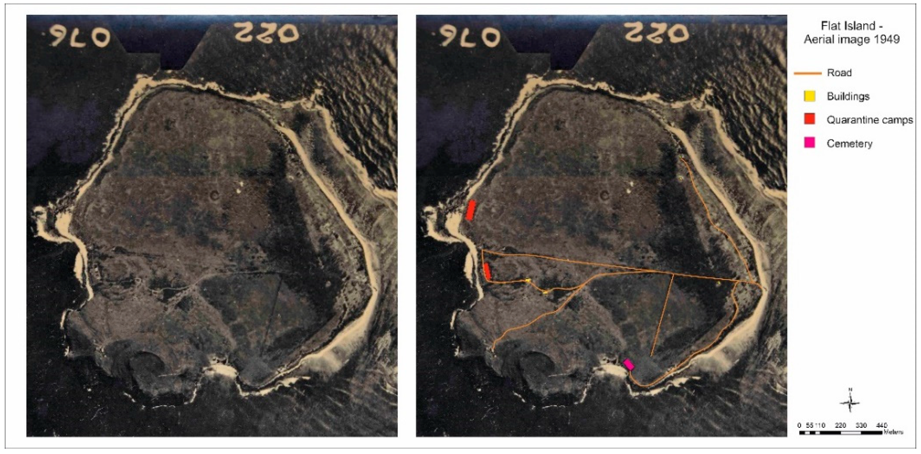
Figure 5). Our latest acquisition was an exceptional 1949 aerial image that displays good visibility and preservation of the station’s infrastructure almost a century ago (
Figure 6).
The production of a detailed three-dimensional map of the landscape, and the immediate seascape of the island with its reef and coastal environment using UAV images and HD video from the entire island, is ongoing and should be completed by 2023 [
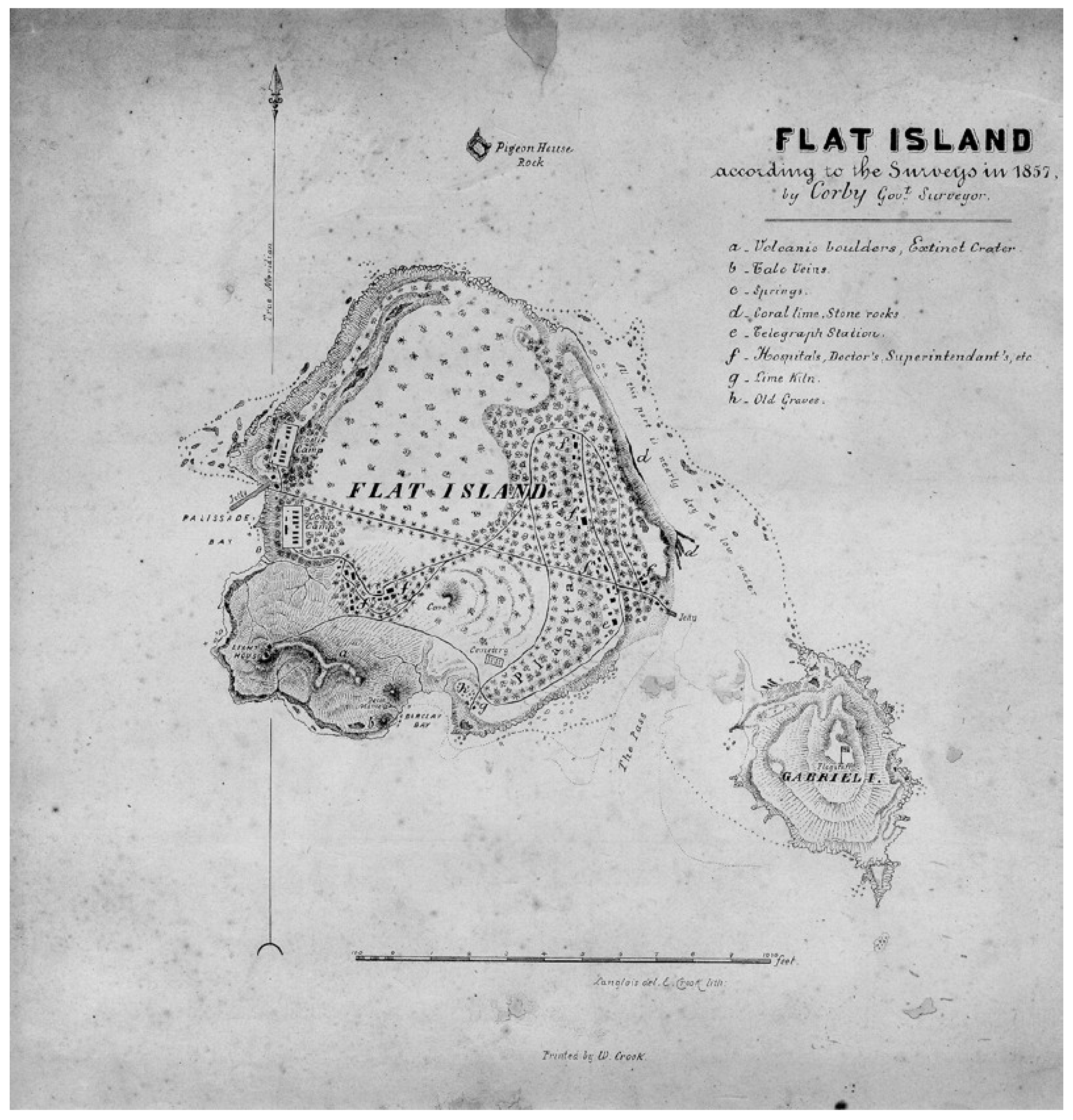
39]. Nevertheless, the aerial photographs provided by drones have been crucial to the research team on the ground, helping us better understand the connections between different zones of the station. By overlaying various historical maps with current images—from the detailed plan of the quarantine island of 1857 by the government surveyor Thomas Corby (
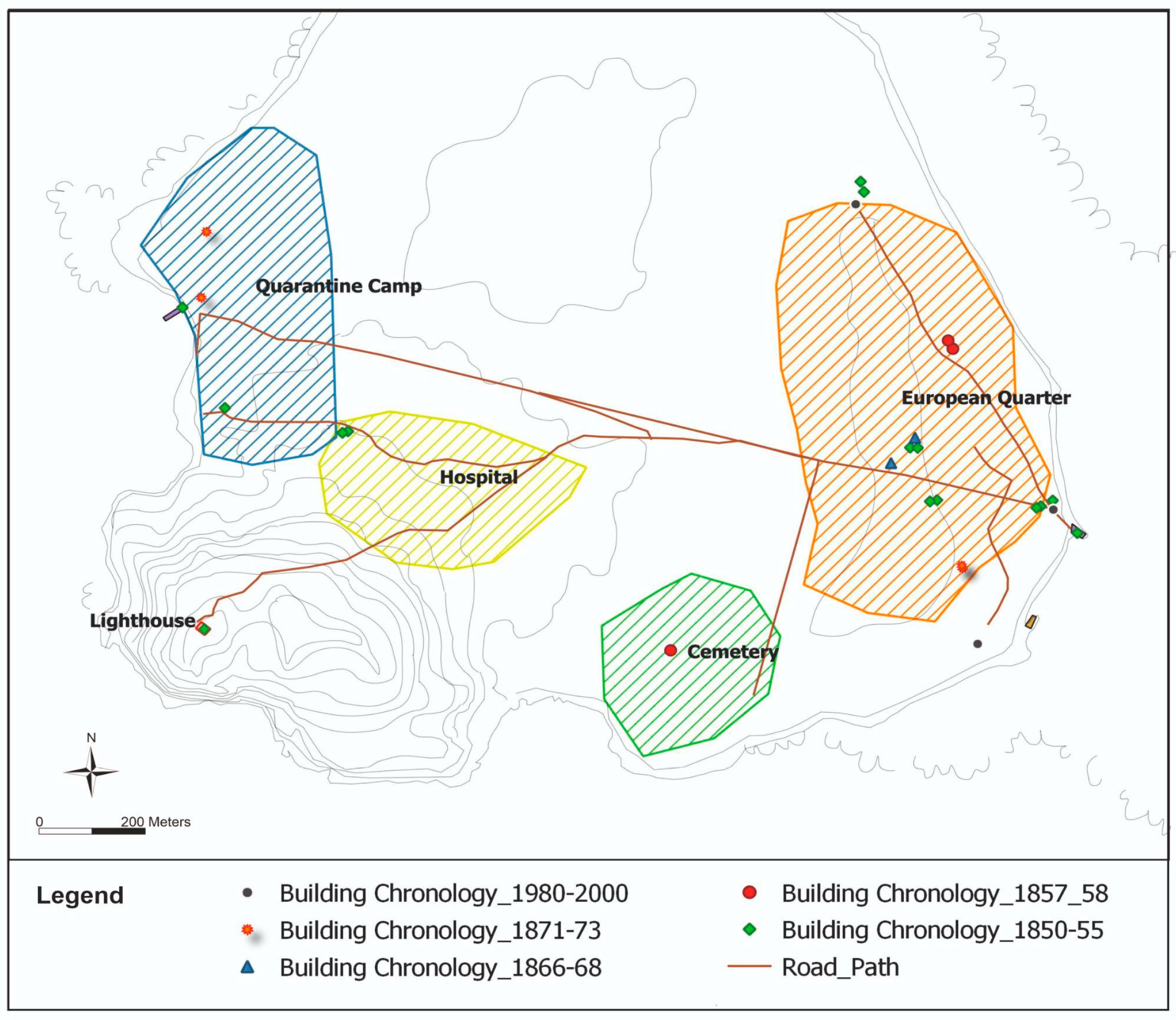
Figure 7) to its construction and current state corroborated on the ground—we aim to present a diachronic sequence of detailed maps of the quarantine island from the various decades of the 19th through the 20th century. The map produced so far illustrates the construction of the essential buildings between 1850 and 1855: the lighthouse, the camp 1, the hospital, the baggage store, and the police station, followed by the cemetery and other colonial houses in the European quarter (1857–1858). Ten years later (1866–1868), a technological improvement in the supply of water and medicines was achieved by constructing the distillation plant to obtain freshwater and the pharmacy, i.e., the store for medical comfort. Archival sources indicate that at the same time officials in charge of the station also sought to implement food supply on the island by employing gardeners and cowherds to produce fresh vegetables and meat directly on the island (
Figure 8).
3.2. Standing Architecture
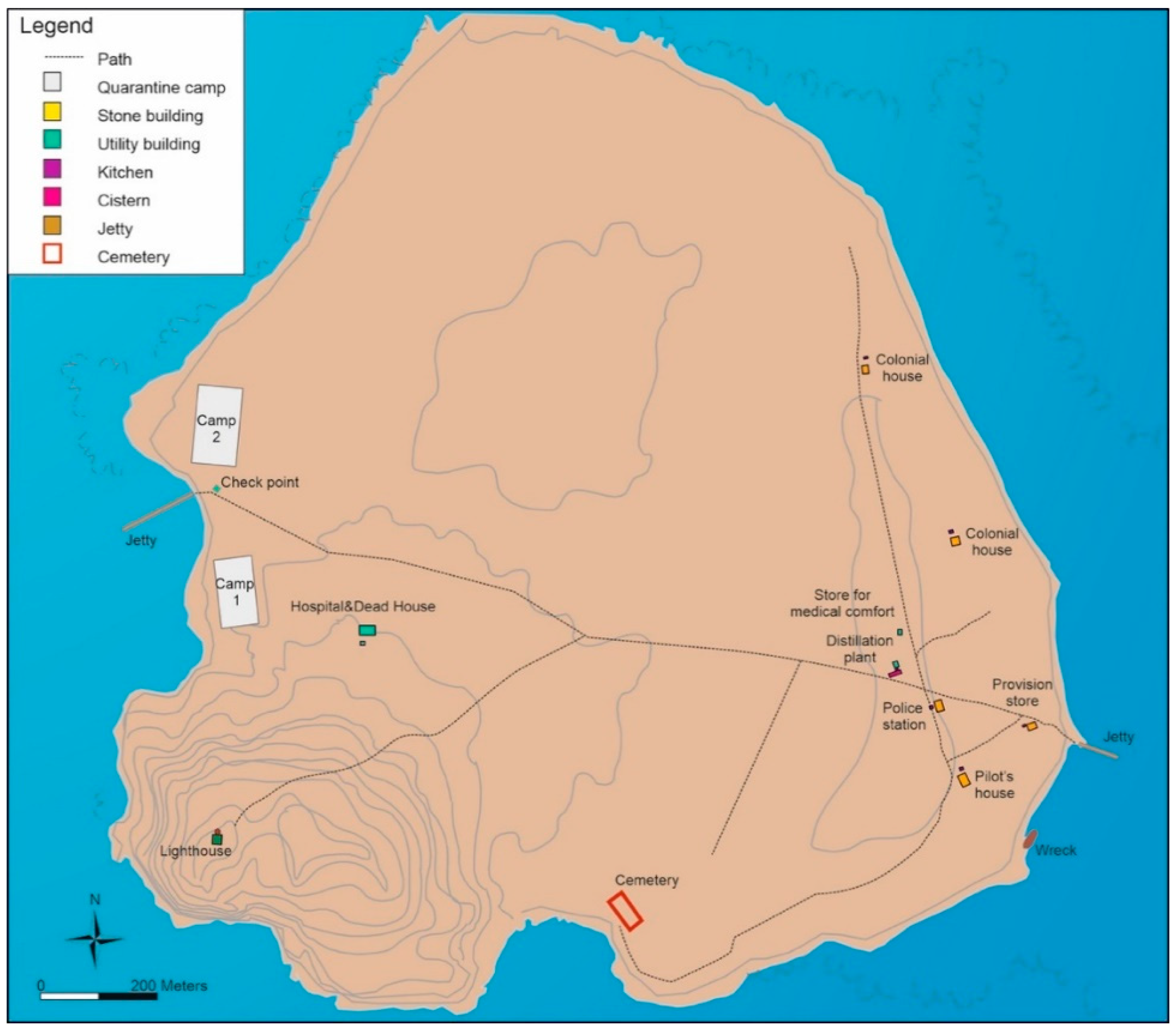
A GIS platform was used to position and manage the localization of the remains of the historical features still present on the quarantine island. With gathered information, we created a detailed map to clearly and precisely locate, identify, and phase all man-made features on the island (
Figure 9). We identified most of the structures depicted on historical maps and architectural plans (two to four per campaign). In addition, we were able to identify water tanks, pipe systems to collect rainwater from roofs, and several latrines located in the vicinity of most of the stone buildings.
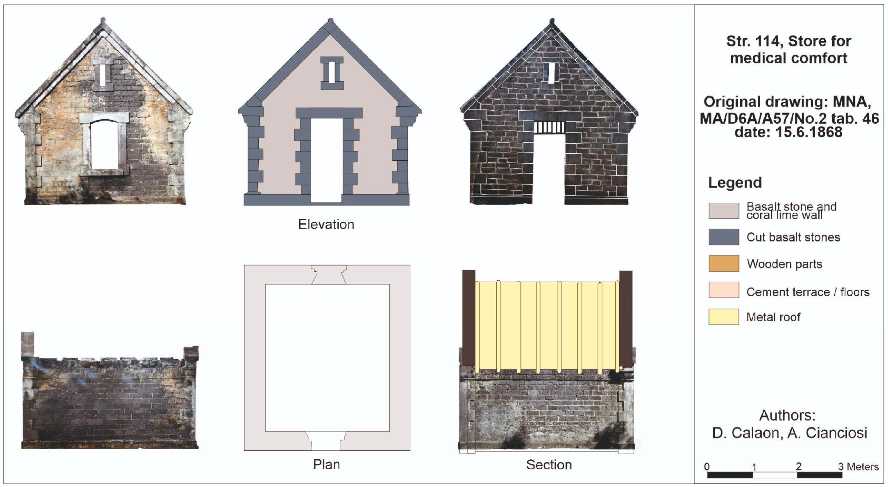
The masonry structures identified so far constitute four main wards: the administrative district (European quarter), the sick ward (with the hospital and the dead house), the quarantine camps (Camp 1 and Camp 2), and the cemetery. The administration buildings included the structures used by officials in charge of the institution (police, pilot, and doctor) but also the telegraph station and the arrival and storage area. The storage of food, water, and medical supplies was a particularly sensitive issue in managing a quarantine station far from the mainland. The best well-maintained buildings were the ones with the distilling apparatus and the pharmacy, called store for medical comfort, located close to the police station. The colonial-style structures characterized the officials’ accommodation and provided private rooms, separate masonry kitchens, and good ventilation, favored by verandahs.
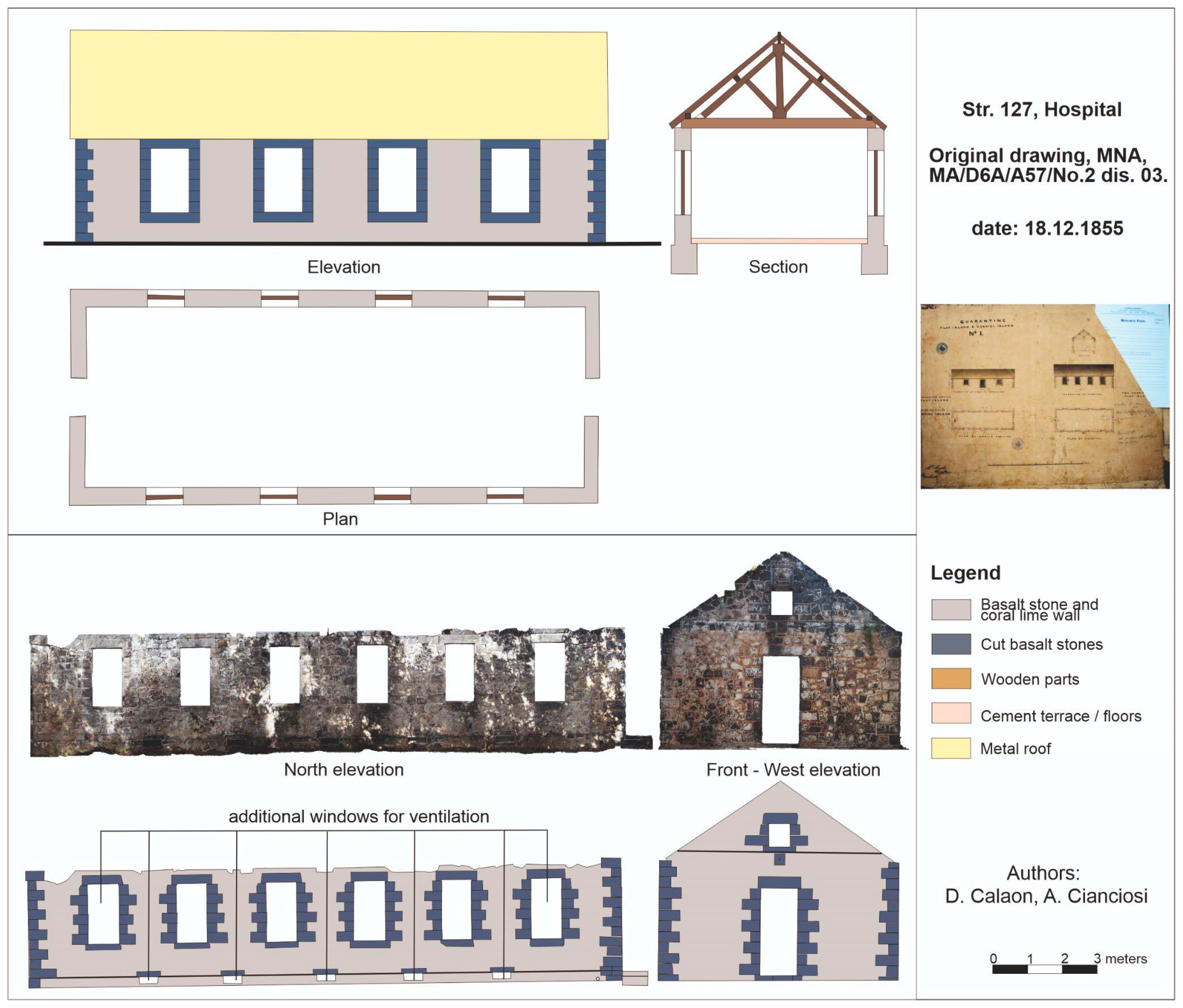
On the island’s leeward side, the indentured workers lived in wooden barracks, often overcrowded and lacking windows or other openings that would provide minimal ventilation. In the 1870s, as the number of indentured workers traveling on larger and faster steamships increased, quarantine camps expanded. Their living conditions gradually improved by adding kitchens, latrines, pipelines, and the use of more durable materials such as concrete for platforms and covers of water cisterns to replace the original rotten wooden structures. Halfway between two wards, although slightly closer to the camps, was the hospital and the morgue, i.e., the dead house, a small masonry building where corpses were examined. Both were built in 1855, as were most essential facilities, but unlike others, both show changes to the original plan, reflecting the advancement of healthcare management.
After the detailed photographic documentation on the field, the photogrammetry and 3D model of twenty buildings have been produced so far (
Table 2). When comparing these with the historical architectural drawings, it becomes evident that the implementation of the architectural designs was faithful only in some cases. For example, the store for medical comfort was constructed from masoned basalt blocks in 1868, closely following the architectural design, and still stands as a solid structure (
Figure 10). The plan included safety measures—narrow entrance, few windows, and additional security measures such as metal bars on windows—but also a ventilator to ensure optimal storage conditions. In other instances, buildings differed from the architectural plan due to practical or functional requirements. Such was the case of the hospital connected with the quarantine camp, constructed larger than originally designed (
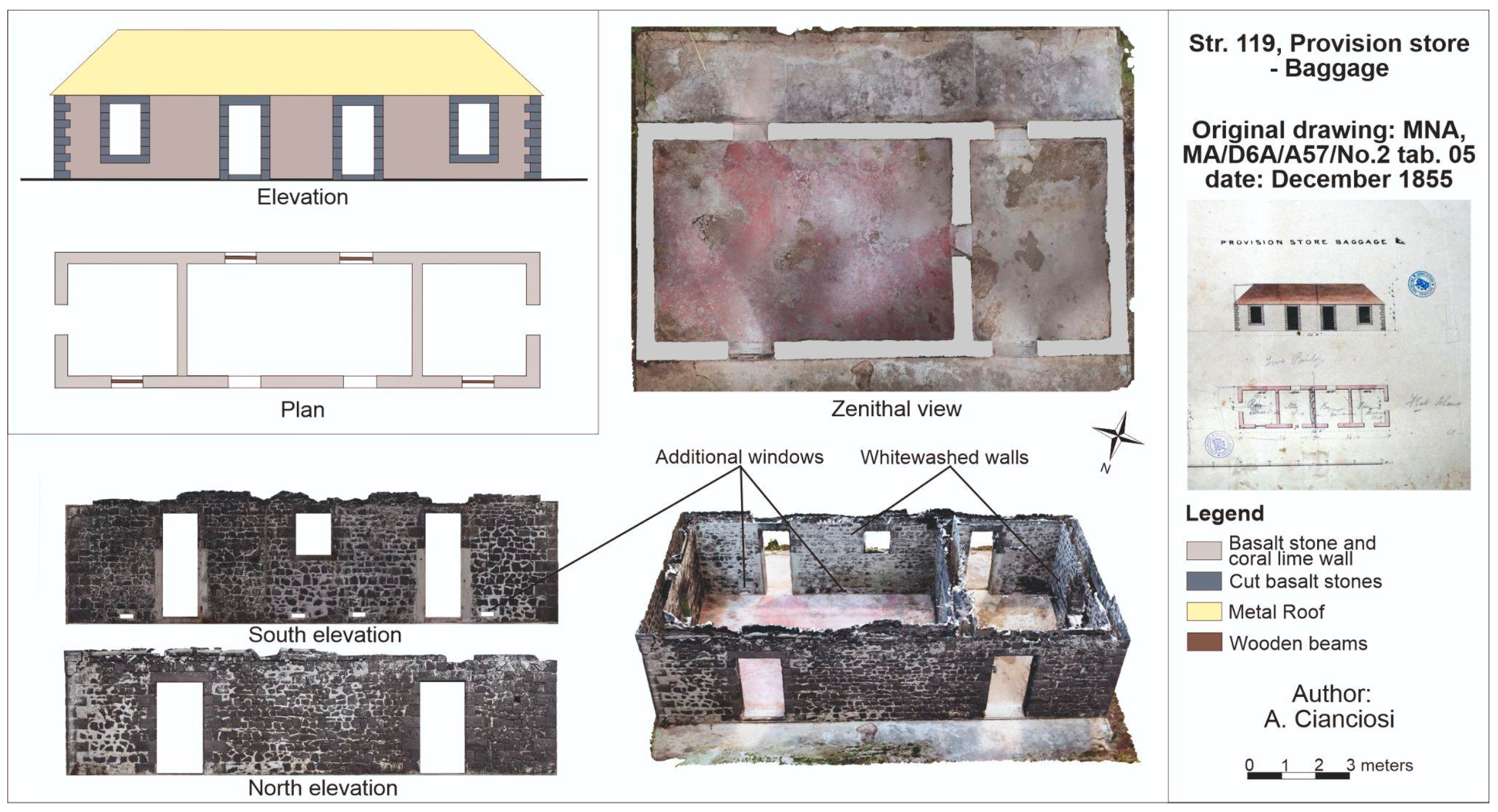
Figure 11), with further health measures built into the architecture itself (floor opening for airing the rooms, larger windows, higher ceiling, and whitewashed walls). Another such example is the baggage store, to which doors were added in place of windows, possibly to increase ventilation. In addition, the door jambs and the interior walls were whitewashed, which was the usual method for cleaning and purifying infected buildings [
40] (pp. 11–13) (
Figure 12). The stratigraphical analysis of standing structures was performed by photogrammetric documentation. It conveyed the requirements for architectural alterations or improvements of buildings during their use but also poor preservation of some structures, which occurred after their disuse in the 20th century (see
Supplementary Materials).
3.3. Communication Features
Flat Island had only a few roads linking various parts of the quarantine facility, with the main road passing in the W–E direction and connecting the two docking piers: the jetty in “Palissade bay”, where indentured immigrants disembarked and were stationed in the two camps, and the so-called European jetty. Of the former, only the base remains; the basalt foundation is firmly embedded in the island’s shoreline, with a segment of a large chain denoting the structure’s function. The wooden pier has disintegrated over time, except for one stubborn pillar indicating its existence. The European jetty is recognizable in the pile of masoned basalt blocks in the passage between Flat Island and Ilot Gabriel. The smaller roads, leading off from the main road, traveled mostly north and south to reach the other wards of the quarantine station (
Figure 7). Other than the small portion of the main road, restored a few decades ago and preserved by the NPCS, all the other roads are overgrown and buried.
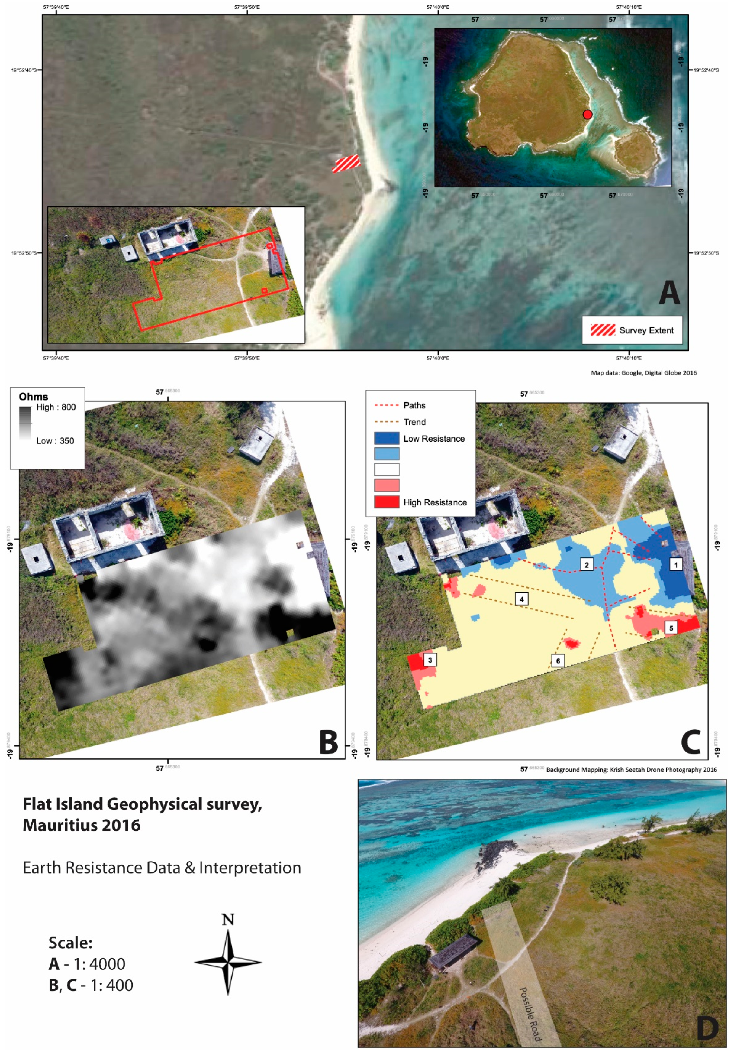
Anticipating the type of information a large-scale geophysical survey would bring, a pilot survey was performed around structures in the south of the island in the vicinity of the European jetty, directly south of Str. 119 (the baggage store). Due to the soil composition and vegetation level, only the electrical resistance technique was performed. The survey was conducted in accordance with the current standards and guidance [
41]. Data processing was kept to a minimum to reduce any significant alteration of the measured data and prevent artifacts within the data from being falsely created. To the west of the survey area, a rectilinear shaped high resistance anomaly can be seen (
Figure 13), indicating the southern corner of a structure in the same alignment with the extant buildings in the area.
A moderately high resistance band runs through the dataset, located in areas 4 and 5 in
Figure 13C. This could represent the former trackway seen on Corby’s map. The linear anomaly appears to extend in the direction of the extant jetty to the east (
Figure 13D). There is a further possible high-resistance band to the south, marked as area 6, which may indicate a further road adjoining this at a roughly perpendicular angle.
4. Discussion
Research on Flat Island can be challenging due to the lack of infrastructure and low accessibility, especially when the sea is rough. Although numerous factors encouraged a comprehensive archaeo-historical investigation, the primary motivation was the unique nature of the site, which is probably the best-preserved colonial period quarantine station in the entire Indian Ocean, if not globally. The first survey of the island ascertained the presence and excellent preservation of stone buildings, dating to the second half of the 19th century. We learned from archival documentation that these structures were dispersed throughout the island (approx. 2.53 km2), grouped into a few functionally and spatially distinct quarters, and connected by roads and paths.
The objective of this phase of research was to document the preserved cultural heritage and understand the rationale behind the installation and management of a new permanent quarantine station, created to combat cholera epidemics and used intensively for a short period. From the outset, the research developed along two main approaches: (1) one on a larger scale, seeking to produce comprehensive documentation of the island given its peculiar environmental character and the lack of current topographical mapping and (2) an in-depth, detailed analysis to verify the actual presence and the state of conservation of the structures during the use of the station.
Following this general assessment, our team focused on the details of the quarantine infrastructure. Individual structures were identified through historical architectural plans and verified on site. Documentation was expanded by fieldwork findings and the base map was updated with additional features. The most effective method to document the standing archaeology was digital image-based modelling combined with UAV mapping.
The photogrammetric images and 3D modelling were essential for performing a detailed stratigraphic analysis of the standing architecture, which allowed us to create chronological maps.
The spatial analysis of the quarantine site provided insights into the preferences for microlocations of specific buildings and practical uses of the space according to the sanitary demands of the time. When designing hospitals, infirmaries, or other health facilities in the 19th century, the primary concern was to create an environment where the air would not become contaminated and have a harmful, disease-causing effect. Natural processes, such as respiration, excretion, putrefaction, and aerial stagnation within closed spaces, were identified as the leading causes of air corruption. Early ventilation strategies included exact site choice and window placement, which, with added fans and ventilators, aimed to bring an ample supply and circulation of air [
40] (pp. 4–6). Thus, when the Mauritius government decided to establish a permanent quarantine station, it chose a completely uninhabited island exposed to oceanic winds, ensuring naturally clean and constantly purified air. However, to maintain this condition within the buildings, efficient ventilation was the main driver for the location of different quarters and the construction of the individual buildings. This important element was understood exclusively through the archaeological analysis of each zone and structures within, revealing the crucial role of the built environment in the comprehension of the quarantine stations.
Flat Island had a specific social organization tied to the spatial and functional structure of a confinement site [
42]. It was segregated based on health, gender, class, and race, like other facilities of similar nature, i.e., the North Head quarantine station in Sydney, Australia [
43] (pp. 98–99). This spatial segregation was achieved and maintained by combining natural topography, positioning of administrative buildings and paths, and the use of barriers, such as walls and fences. Furthermore, on Flat Island, the ventilation also seemed to be a discriminating factor; while being regularly implemented in the administrative district for European officials, it was completely disregarded in the quarantine camps, which housed almost exclusively indentured workers. Yet, this element was never absent in the hospital: windows were placed on opposite walls to ensure cross-ventilation, smaller openings at the bottom of a wall provided constant air circulation, and the frequent whitewashing of the walls resulted in regular disinfection of rooms [
44] (46–52).
In addition to the main structures that have been located and documented, there were many other auxiliary, often wooden structures, especially in the quarantine camps—the kitchen shed, the warehouse, and other temporary shelters—which only a proper excavation or a large-scale geophysical survey could detect. The increased interest in modelling large archaeological sites, both in a cultural and natural setting, suggests that the archaeological remote sensing data produced at Flat Island serve as a unique repository of the current state of such heritage. The materials available here can be used to promote this unique site in Mauritius and across the entire Indian Ocean. Indeed, the conservation and management of this heritage site rely heavily on the availability and timeliness of data; thus, the further implementation of remote sensing techniques will be necessary.
In the future, methods such as Lidar mapping could reveal buried structures, such as water cisterns, hut platforms in Camp 2, or even the exact route of the main road between the two jetties, as well as orchards, gardens, and plantations utilized during the station’s operation. This, combined with a multidisciplinary collaboration between image analysts, archaeologists, and conservation scientists to effectively implement the use of Synthetic Aperture Radar (SAR) imagery, would be useful for prospecting cultural landscapes and investigating processes related to heritage transformation at this archaeological site [
45,
46].
5. Conclusions
This article showcases research combining existing remote sensing methods: the traditional use of historical and aerial images was integrated with UAV and terrestrial photogrammetry. This study, carried out over five years, allowed us to gather copious amounts of historical and archaeological data on an extraordinarily well-preserved site.
The results provide a unique example for the comparative perspective in the archaeology of healthscaping, and the first and most detailed documentation of the built cultural heritage preserved on Flat Island. Beyond an accurate reconstruction of the material configuration of this quarantine station, the research allowed us to analyze its hierarchical social structure and its segregation patterns, which were influenced by disease and medical theory of the time. The proposed approach can be applied to other regions and colonial empires, including beyond the Indian Ocean, where different forms of historical healthscaping can be traced.


