
Basalt Chronology of the Orientale Basin Based on CE-2 CCD Imaging and Implications for Lunar Basin Volcanism


Abstract
:1. Introduction
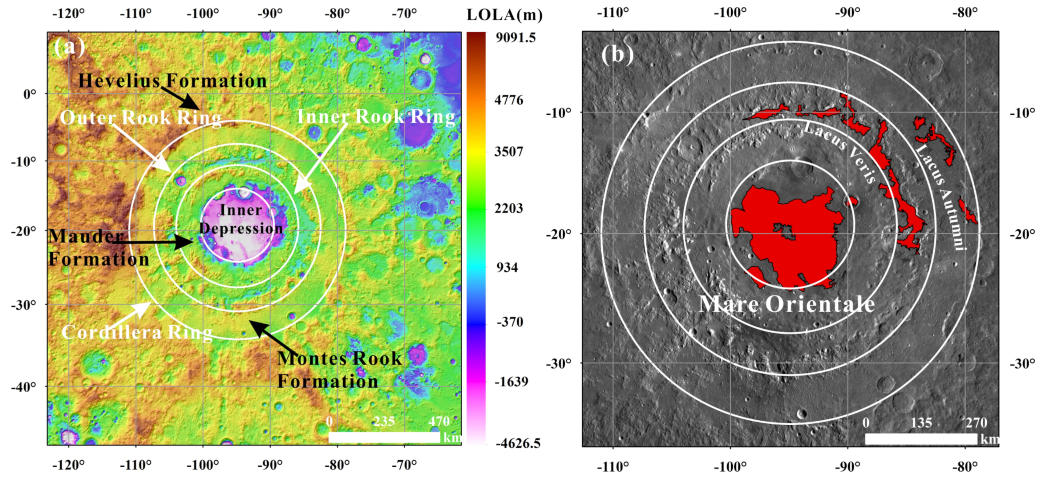
2. Orientale Basin
3. Data and Methods
3.1. Crater Size-Frequency Distribution (CSFD) Model
3.2. Data
4. Results
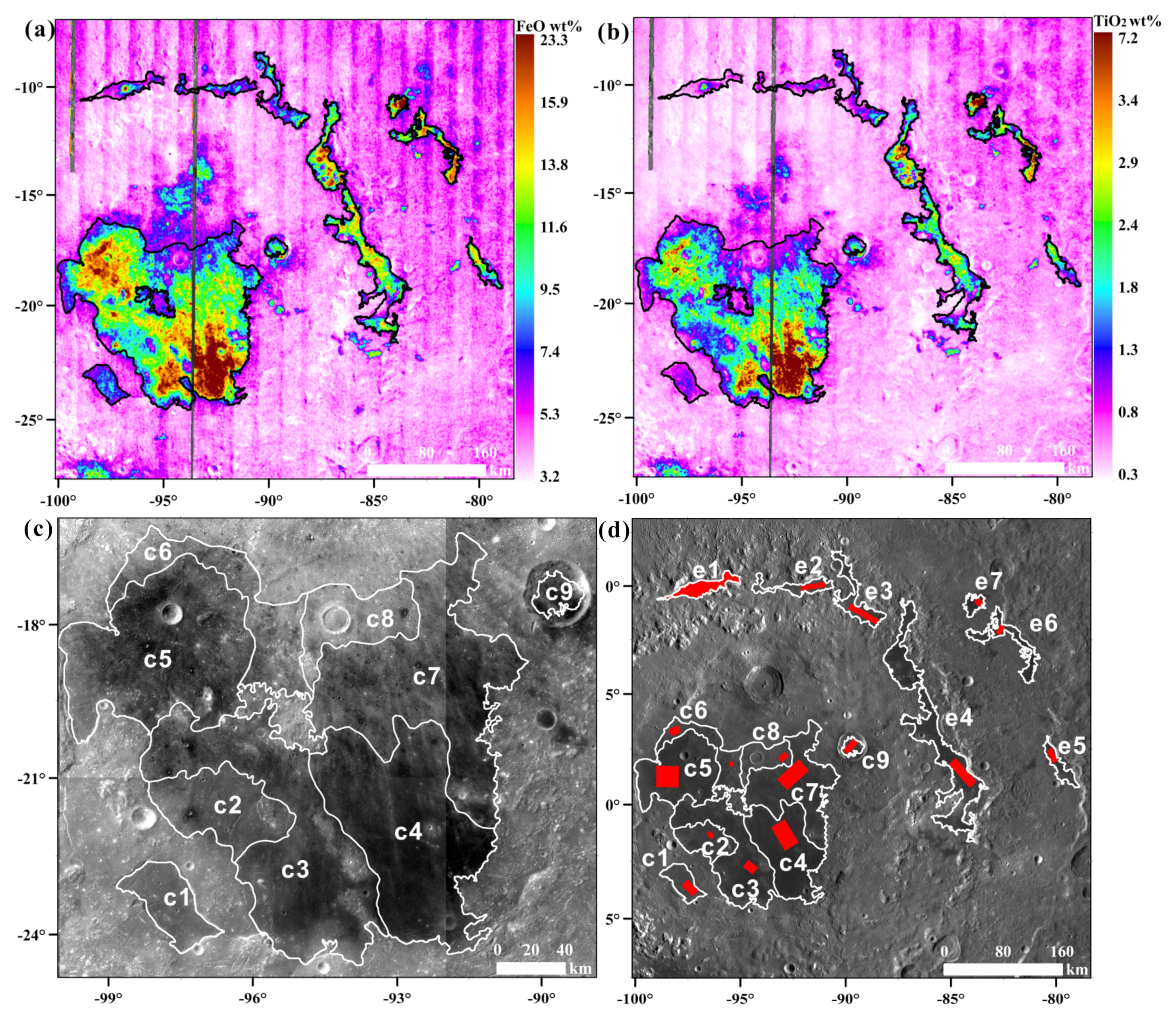
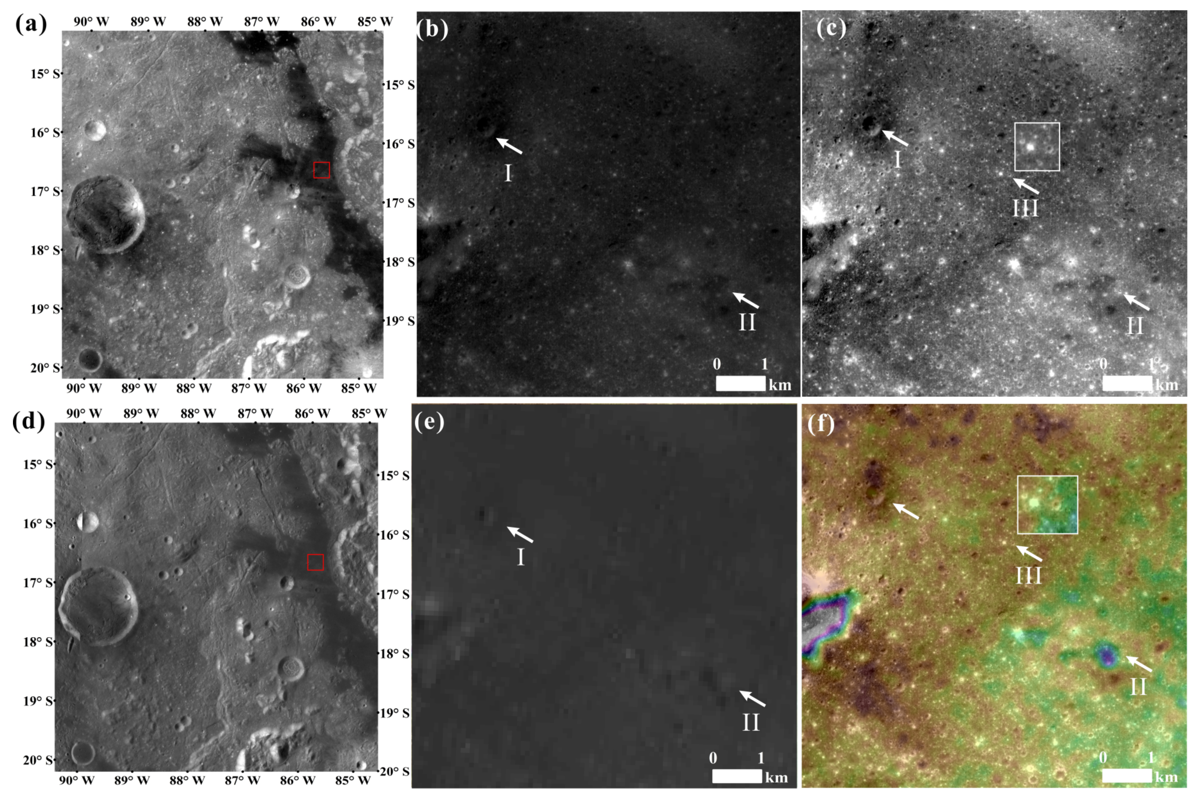
4.1. Basaltic Area Identification
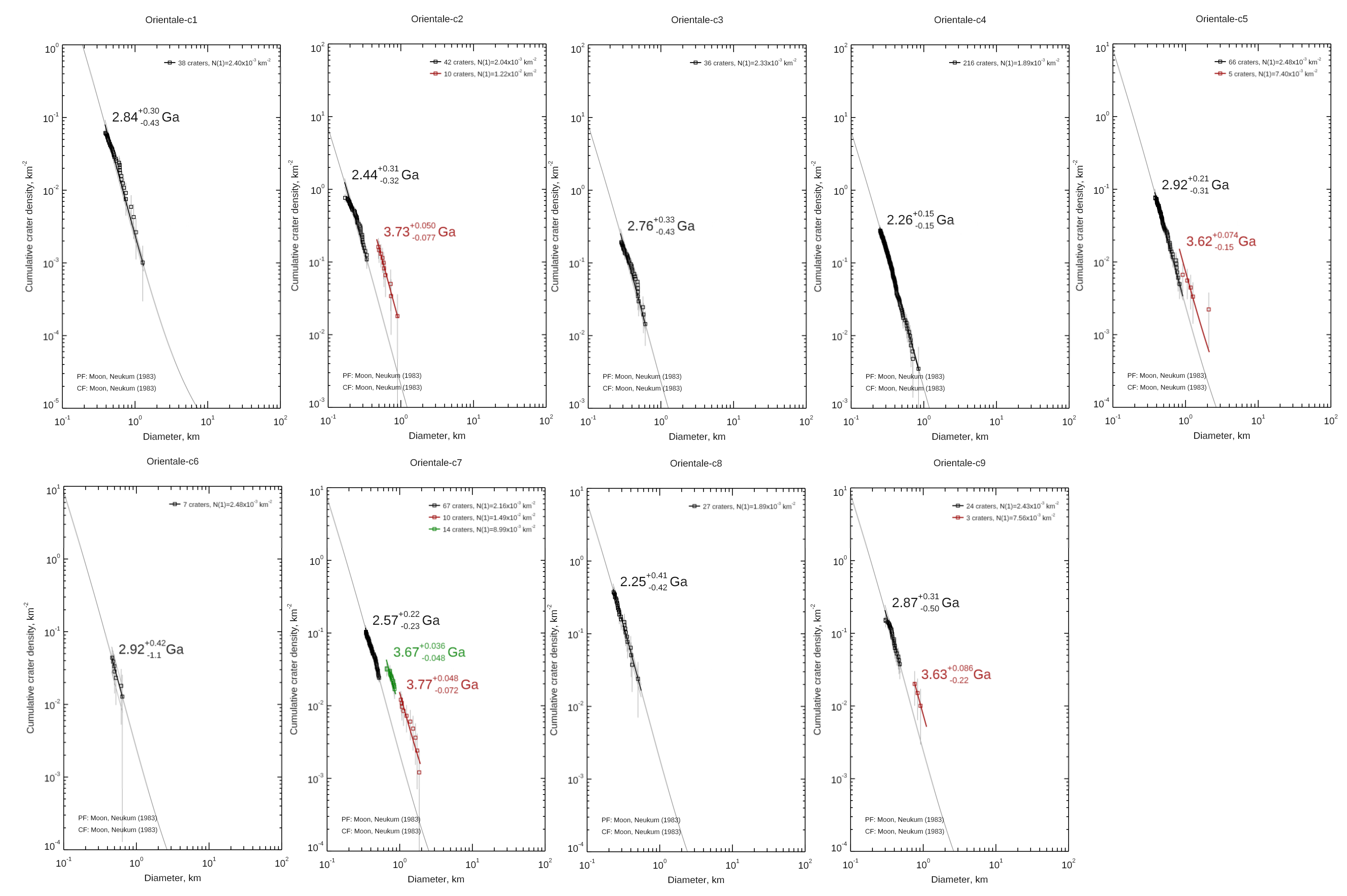
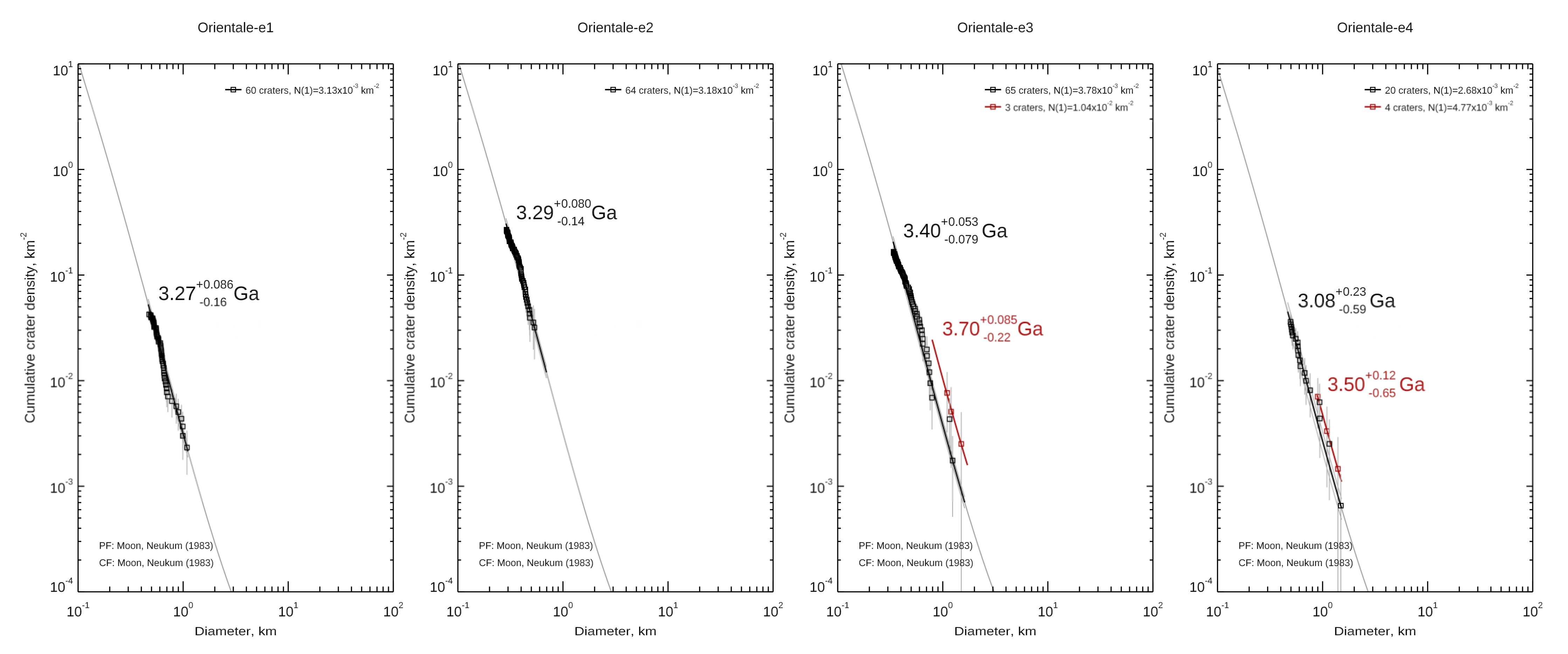
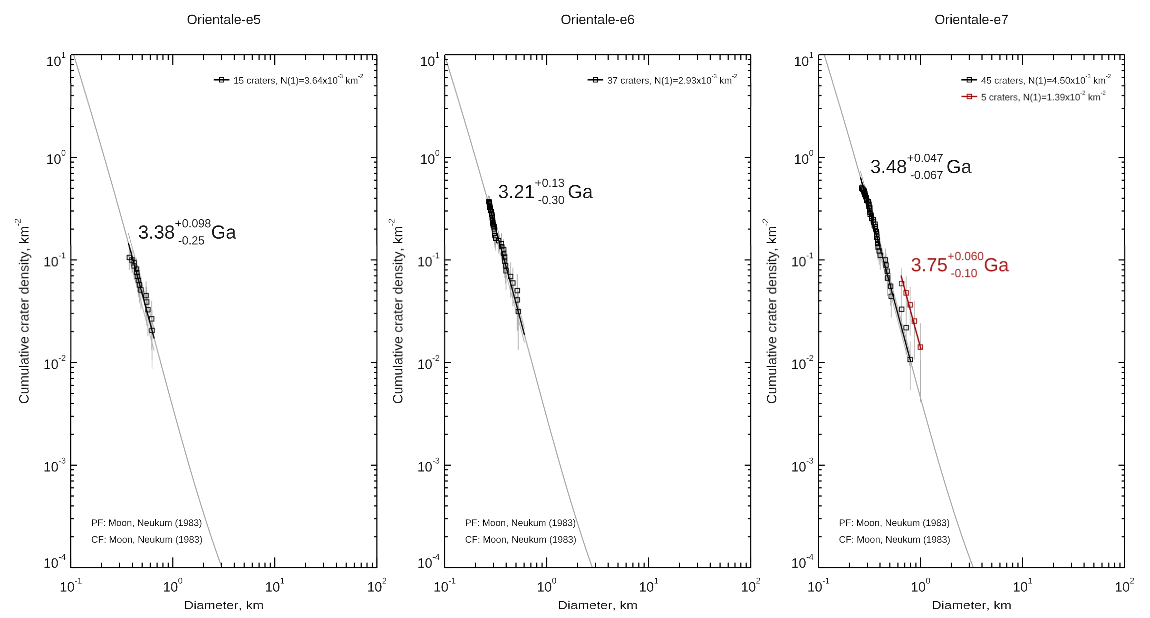
4.2. Crater Retention Ages
5. Discussion
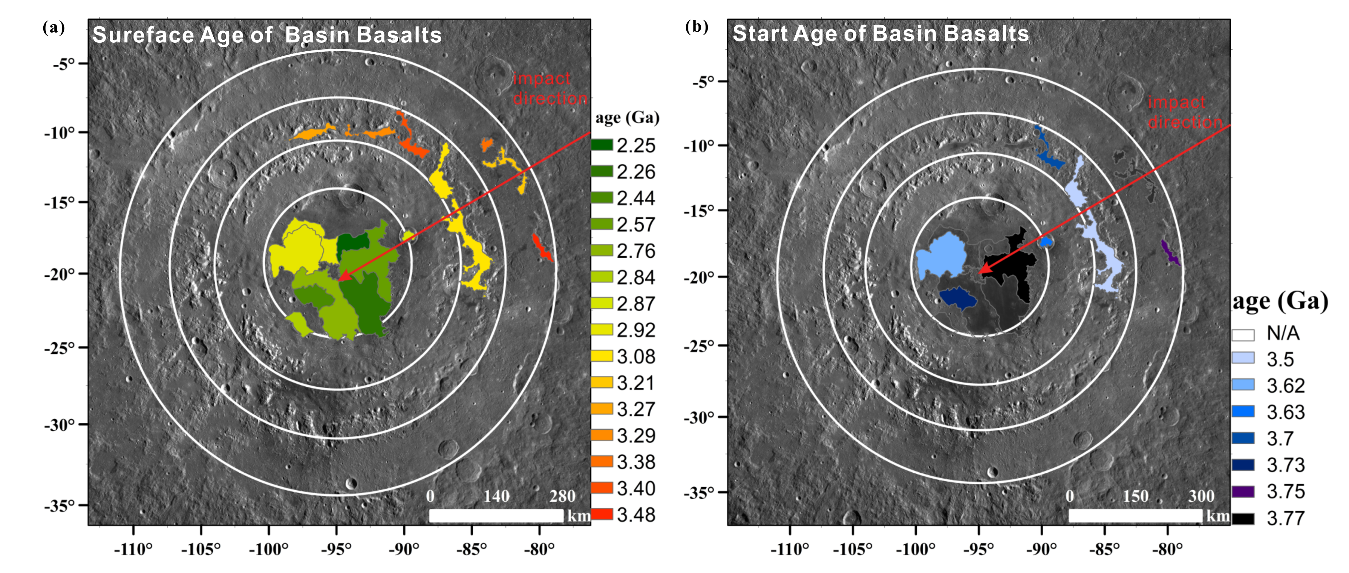
5.1. Implications to the Volcanic History in the Orientale Region
5.2. Implications for the Basin Volcanism
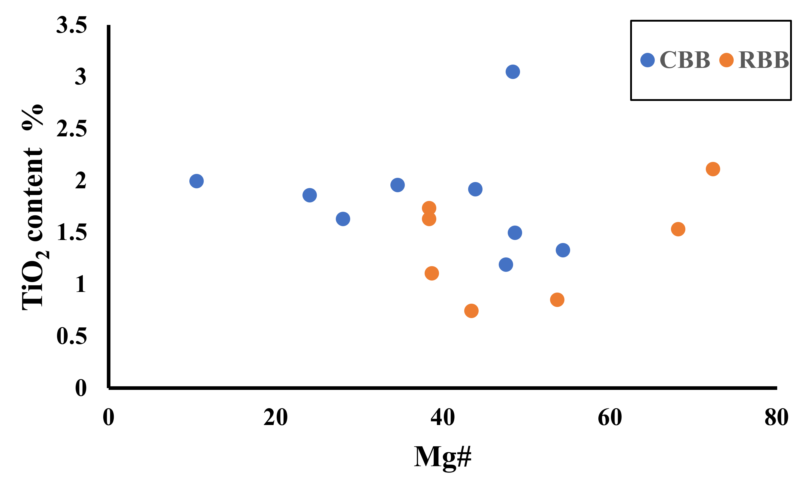
5.2.1. TiO2 and Mg# Contents of the Orientale Basalts
5.2.2. Relationship between Impact Direction and Basalt Distribution
5.2.3. Model for the Basin Volcanic Formation
6. Conclusions
Supplementary Materials
Author Contributions
Funding
Institutional Review Board Statement
Informed Consent Statement
Data Availability Statement
Acknowledgments
Conflicts of Interest
References
- Moriarty, D.P., 3rd; Dygert, N.; Valencia, S.N.; Watkins, R.N.; Petro, N.E. The search for lunar mantle rocks exposed on the surface of the Moon. Nat. Commun. 2021, 12, 4659. [Google Scholar] [CrossRef] [PubMed]
- Kruijer, T.S.; Kleine, T. Tungsten isotopes and the origin of the Moon. Earth Planet. Sci. Lett. 2017, 475, 15–24. [Google Scholar] [CrossRef]
- Ziethe, R.; Seiferlin, K.; Hiesinger, H. Duration and extent of lunar volcanism: Comparison of 3D convection models to mare basalt ages. Planet. Space Sci. 2009, 57, 784–796. [Google Scholar] [CrossRef]
- Dygert, N.; Hirth, G.; Liang, Y. A flow law for ilmenite in dislocation creep: Implications for lunar cumulate mantle overturn. Geophys. Res. Lett. 2016, 43, 532–540. [Google Scholar] [CrossRef]
- Hess, P.C.; Parmentier, E. A model for the thermal and chemical evolution of the Moon’s interior: Implications for the onset of mare volcanism. Earth Planet. Sci. Lett. 1995, 134, 501–514. [Google Scholar] [CrossRef] [Green Version]
- Hiesinger, H.; Jaumann, R.; Neukum, G.; Head, J.W. Ages of mare basalts on the lunar nearside. J. Geophys. Res. Planets 2000, 105, 29239–29275. [Google Scholar] [CrossRef]
- Hiesinger, H.; Head, J.W.; Wolf, U.; Jaumann, R.; Neukum, G. Ages and stratigraphy of lunar mare basalts in Mare Frigoris and other nearside maria based on crater size-frequency distribution measurements. J. Geophys. Res. Planets 2010, 115, 1–22. [Google Scholar] [CrossRef] [Green Version]
- Hiesinger, H.; Head, J.W.; Wolf, U.; Jaumann, R.; Neukum, G. Ages and stratigraphy of mare basalts in Oceanus Procellarum, Mare Nubium, Mare Cognitum, and Mare Insularum. J. Geophys. Res. Planets 2003, 108, 1–27. [Google Scholar] [CrossRef] [Green Version]
- Hiesinger, H.; Head, J.; Wolf, U.; Jaumann, R.; Neukum, G.; Advances, J.R. Ages and stratigraphy of lunar mare basalts: A synthesis. Lunar Stratigr. 2011, 477, 1–51. [Google Scholar] [CrossRef] [Green Version]
- Morota, T.; Haruyama, J.; Ohtake, M.; Matsunaga, T.; Honda, C.; Yokota, Y.; Kimura, J.; Ogawa, Y.; Hirata, N.; Demura, H.; et al. Timing and characteristics of the latest mare eruption on the Moon. Earth Planet. Sci. Lett. 2011, 302, 255–266. [Google Scholar] [CrossRef]
- Lucey, P.G.; Blewett, D.T.; Hawke, B.R. Mapping the FeO and TiO2 content of the lunar surface multispectral imagery. J. Geophys. Res. Planets 1998, 103, 3679–3699. [Google Scholar] [CrossRef]
- Pasckert, J.H.; Hiesinger, H.; van der Bogert, C.H. Lunar farside volcanism in and around the South Pole–Aitken basin. Icarus 2018, 299, 538–562. [Google Scholar] [CrossRef]
- Head, J.W.; Wilson, L. Lunar Mare Volcanism: Stratigraphy, Eruption Conditions, and the Evolution of Secondary Crusts. Geochim. Cosmochim. Acta 1992, 56, 2155–2175. [Google Scholar] [CrossRef]
- Head, J.W.; Hawke, B.R. Geology of the Apollo 14 region/Fra Mauro/-Stratigraphic history and sample provenance. In Proceedings of the 6th Lunar Science Conference, Houston, TX, USA, 17–21 March 1975; Volume 6, pp. 2483–2501. [Google Scholar]
- Arivazhagan, S. Quantitative Characterization of lunar Mare Orientale basalts detected by moon mineralogical mapper on Chandrayaan-1. In Planetary Exploration and Science: Recent Results and Advances; Springer: Berlin/Heidelberg, Germany, 2015; pp. 21–43. [Google Scholar]
- Jolliff, B.L.; Gillis, J.J.; Haskin, L.A.; Korotev, R.L.; Wieczorek, M.A. Major lunar crustal terranes: Surface expressions and crust-mantle origins. J. Geophys. Res. Planets 2000, 105, 4197–4216. [Google Scholar] [CrossRef] [Green Version]
- Liu, J.; Liu, J.; Yue, Z.; Zhang, L.; Wang, J.; Zhu, K. Characterization and interpretation of the global lunar impact basins based on remote sensing. Icarus 2022, 378, 114952. [Google Scholar] [CrossRef]
- Baldwin, R.B. Summary of arguments for a hot moon. Science 1970, 170, 1297–1300. [Google Scholar] [CrossRef] [PubMed]
- Arkani-Hamed, J. On the thermal history of the moon. Moon 1973, 6, 380–383. [Google Scholar] [CrossRef]
- Whitten, J.; Head, J.W.; Staid, M.; Pieters, C.M.; Mustard, J.; Clark, R.; Nettles, J.; Klima, R.L.; Taylor, L. Lunar mare deposits associated with the Orientale impact basin: New insights into mineralogy, history, mode of emplacement, and relation to Orientale Basin evolution from Moon Mineralogy Mapper (M3) data from Chandrayaan-1. J. Geophys. Res. Planets 2011, 116, E00G09. [Google Scholar] [CrossRef] [Green Version]
- Yue, Z.; Yang, M.; Jia, M.; Michael, G.; Di, K.; Gou, S.; Liu, J. Refined model age for Orientale Basin derived from zonal crater dating of its ejecta. Icarus 2020, 346, 113804. [Google Scholar] [CrossRef]
- Nahm, A.L.; Ohman, T.; Kring, D.A. Normal faulting origin for the Cordillera and Outer Rook Rings of Orientale Basin, the Moon. J. Geophys. Res. Planets 2013, 118, 190–205. [Google Scholar] [CrossRef]
- Wilhelms, D.E.; John, F.; Trask, N.J. The Geologic History of the Moon; United States Government Publishing Office: Washington, DC, USA, 1987; pp. 2330–7102. [Google Scholar] [CrossRef] [Green Version]
- Neukum, G.; König, B.; Arkani-Hamed, J. A study of lunar impact crater size-distributions. Moon 1975, 12, 201–229. [Google Scholar] [CrossRef]
- Baldwin, R.B. On the Relative and Absolute Ages of 7 Lunar Front Face Basins: II. From Crater Counts. Icarus 1987, 71, 19–29. [Google Scholar] [CrossRef]
- Greeley, R. Modes of emplacement of basalt terrains and an analysis of mare volcanism in the Orientale Basin. In Proceedings of the Lunar and Planetary Science Conference Proceedings, Houston, TX, USA, 15–19 March 1976; pp. 2747–2759. [Google Scholar]
- Greeley, R.; Kadel, S.D.; Williams, D.A.; Gaddis, L.R.; Head, J.W.; McEwen, A.S.; Murchie, S.L.; Nagel, E.; Neukum, G.; Pieters, C.M.; et al. Galileo imaging observations of lunar maria and related deposits. J. Geophys. Res. Planets 1993, 98, 17183–17205. [Google Scholar] [CrossRef] [Green Version]
- Cho, Y.; Morota, T.; Haruyama, J.; Yasui, M.; Hirata, N.; Sugita, S. Young mare volcanism in the Orientale region contemporary with the Procellarum KREEP Terrane (PKT) volcanism peak period ~2 billion years ago. Geophys. Res. Lett. 2012, 39, 1–5. [Google Scholar] [CrossRef]
- Kneissl, T.; van Gasselt, S.; Neukum, G. Map-projection-independent crater size-frequency determination in GIS environments—New software tool for ArcGIS. Planet. Space Sci. 2011, 59, 1243–1254. [Google Scholar] [CrossRef]
- Michael, G.; Neukum, G. Planetary surface dating from crater size–frequency distribution measurements: Partial resurfacing events and statistical age uncertainty. Earth Planet. Sci. Lett. 2010, 294, 223–229. [Google Scholar] [CrossRef]
- Pike, R.J. Geometric Interpretation of Lunar Craters; U.S. Government Printing Office: Washington, DC, USA, 1980. [Google Scholar]
- Oberbeck, V.R.; Morrison, R.H. Laboratory simulation of the herringbone pattern associated with lunar secondary crater chains. Moon 1974, 9, 415–455. [Google Scholar] [CrossRef]
- Melosh, H.J. Impact Cratering: A Geologic Process; Oxford University Press: New York, NY, USA, 1989. [Google Scholar]
- Zuo, W.; Li, C.; Zhang, Z. Scientific data and their release of Chang’E-1 and Chang’E-2. Chin. J. Geochem. 2014, 33, 24–44. [Google Scholar] [CrossRef]
- Wu, Y.; Xue, B.; Zhao, B.; Lucey, P.; Chen, J.; Xu, X.; Li, C.; Ouyang, Z. Global estimates of lunar iron and titanium contents from the Chang’E-1 IIM data. J. Geophys. Res. Planets 2012, 117, 1–23. [Google Scholar] [CrossRef]
- Prettyman, T.H.; Hagerty, J.J.; Elphic, R.C.; Feldman, W.C.; Lawrence, D.J.; McKinney, G.W.; Vaniman, D.T. Elemental composition of the lunar surface: Analysis of gamma ray spectroscopy data from Lunar Prospector. J. Geophys. Res. Planets 2006, 111, 1–41. [Google Scholar] [CrossRef]
- Morota, J.; Ohtake, M.; Matsunaga, T.; Yokota, Y.; Honda, C.; Sugihara, T.; Kimura, J.; Ishihara, Y. Mare Volcanism on the Farside and in the Orientale Region of the Moon. In Proceedings of the 41st Lunar and Planetary Science Conference, The Woodlands, TX, USA, 1–5 March 2010; p. 1309. [Google Scholar]
- Spudis, P.D.; Martin, D.J.; Kramer, G. Geology and composition of the Orientale basin impact melt sheet. J. Geophys. Res. Planets 2014, 119, 19–29. [Google Scholar] [CrossRef]
- Kodama, S.; Yamaguchi, Y. Lunar mare volcanism in the eastern nearside region derived from Clementine UV/VIS data. Meteorit. Planet. Sci. 2003, 38, 1461–1484. [Google Scholar] [CrossRef]
- Hiesinger, H.; Jaumann, R.; Neukum, G.; Head, J. On the relation of age and titanium content of lunar mare basalts. In Proceedings of the 29th Annual Lunar and Planetary Science Conference, Houston, TX, USA, 16–20 March 1998; p. 1243. [Google Scholar]
- Hiesinger, H.; Head, J.; Wolf, U.; Neukum, G. Lunar mare basalts: Mineralogical variations with time. In Proceedings of the 32nd Lunar and Planetary Science Conference, Houston, TX, USA, 12–16 March 2001; p. 1826. [Google Scholar]
- Kodama, S.; Yamaguchi, Y. Mare volcanism on the Moon inferred from Clementine UVVIS data. In Proceedings of the 36th Annual Lunar and Planetary Science Conference, League City, TX, USA, 14–18 March 2005; p. 1641. [Google Scholar]
- Taylor, G.J.; Warren, P.; Ryder, G.; Delano, J.; Pieters, C.; Lofgren, G. Lunar rocks. In Lunar Sourcebook; Cambridge University Press: Cambridge, UK, 1991; pp. 183–284. [Google Scholar]
- Cahill, J.; Lucey, P.; Gillis, J.; Steutel, D. Global Mapping of Mg-Number Derived from Clementine Data. In AGU Fall Meeting Abstracts; American Geophysical Union: San Francisco, CA, USA, 17 December 2004; p. P23A-0232. [Google Scholar]
- Schultz, P. Making the man in the moon: Origin of the Imbrium Basin. In Proceedings of the Twenty-sixth Lunar and Planetary Science Conference, Houston, TX, USA, 13–17 March 1995; pp. 1251–1252. [Google Scholar]
- Liu, J.W.; Liu, J.Z.; Guo, D.J.; Ji, J.Z.; Wang, Q.L.; Li, S.J. Comprehensive analysis of the lunar Orientale Basin and research of the initial impact condition. Acta Petrol. Sin. 2016, 32, 135–143. [Google Scholar]
- Morse, Z.R.; Osinski, G.R.; Tornabene, L.L. New morphological mapping and interpretation of ejecta deposits from Orientale Basin on the Moon. Icarus 2018, 299, 253–271. [Google Scholar] [CrossRef]
- Stickle, A.; Schultz, P. Investigating pressure magnitudes at depth for oblique impacts into layered targets: Applications to terrestrial impacts in sedimentary targets. Meteorit. Planet. Sci. 2013, 48, 1638–1650. [Google Scholar] [CrossRef]
- Andrews-Hanna, J.C.; Head, J.W.; Johnson, B.; Keane, J.T.; Kiefer, W.S.; McGovern, P.J.; Neumann, G.A.; Wieczorek, M.A.; Zuber, M.T. Ring faults and ring dikes around the Orientale basin on the Moon. Icarus 2018, 310, 1–20. [Google Scholar] [CrossRef] [Green Version]
- Kenkmann, T.; Poelchau, M.H. Low-angle collision with Earth: The elliptical impact crater Matt Wilson, Northern Territory, Australia. Geology 2009, 37, 459–462. [Google Scholar] [CrossRef]
- Potter, R.W.; Kring, D.A.; Collins, G.S.; Kiefer, W.S.; McGovern, P.J. Numerical modeling of the formation and structure of the Orientale impact basin. J. Geophys. Res. Planets 2013, 118, 963–979. [Google Scholar] [CrossRef]
- Arkani-Hamed, J. Effect of a giant impact on the thermal evolution of the Moon. Moon 1974, 9, 183–209. [Google Scholar] [CrossRef]
- Head, J.W. Lava Flooding of Ancient Planetary Crusts—Geometry, Thickness, and Volumes of Flooded Lunar Impact Basins. Moon Planets 1982, 26, 61–88. [Google Scholar] [CrossRef]


| Basalts Name | Reference | Subunit Name | The surface Age of Basalts (Ga) |
|---|---|---|---|
| Mare Orientale | Greely et al., 1993 [27] | Mare Orientale West (1) | 3.45 |
| Mare Orientale Southeast (2) | 3.45 | ||
| Mare Orientale South-Central (3) | 3.70 | ||
| Cho et al., 2011 [28] | Southwest | 3.77 | |
| SW Polygon | 3.77 | ||
| east | 2.91 | ||
| Whitten et al., 2011 [20] | Mare sheet | 3.64 | |
| Mare Orientale 7 | 3.57 | ||
| Kopff | 3.36 | ||
| Lacus Veris | Greely et al., 1993 [27] | Lacus Veris | 2.85 |
| Cho et al., 2011 [28] | Noth | 2.16, 3.36, 3.56 | |
| South | 2.20 | ||
| Whitten et al., 2011 [20] | 9 | 3.44 | |
| 11 | 3.22 | ||
| 12 | 3.36 | ||
| 14 | 3.20 | ||
| Lacus Autumni | Greely et al., 1993 [27] | Lacus Autumni | 3.85 |
| Cho et al., 2011 [28] | North | 2.03 | |
| Middle | 1.75 | ||
| South | 2.16 | ||
| Whitten et al., 2011 [20] | 21 | 3.47 | |
| 22 | 1.66 | ||
| 23 | 2.38 |
| Unite Name | Neukum et al., (1983) (Ga) | Neukum et al., (2001) (Ga) | Age of Similar Geological Units in Previous Study (Ga) | ||
|---|---|---|---|---|---|
| sAMA 1 (Ga) | eAMA 2 (Ga) | sAMA (Ga) | eAMA (Ga) | ||
| Mare Orientale | |||||
| c1 | 2.84 (+0.30; −0.43) | \ | 2.82 (+0.30; −0.43) | \ | N 3, 3.57 4, 3.77 5 |
| c2 | 2.44 (+0.31; −0.32) | 3.73 (+0.050; −0.077) | 2.33 (+0.30; −0.31) | 3.73 (+0.050; −0.077) | N 3, 3.64 4, 3.77 5 |
| c3 | 2.76 (+0.33; −0.43) | \ | 2.68 (+0.35; −0.42) | \ | 3.70 3, 3.64 4, 3.77 5 |
| c4 | 2.26 (+0.15; −0.15) | \ | 2.18 (+0.15; −0.15) | \ | 3.45 3, 3.64 4, 2.91 5 |
| c5 | 2.92 (+0.21; −0.31) | 3.62 (+0.074; −0.15) | 2.88 (+0.22; −0.31) | 3.62 (+0.075; −0.16) | 3.45 4, 3.64 4, 2.91 5 |
| c6 | 2.92 (+0.42; −1.3) | \ | 2.88 (+0.45; −1.1) | \ | 3.45 a, 3.64 4, 2.91 5 |
| c7 | 2.57 (+0.22; −0.23) | 3.77 (+0.048; −0.032) | 2.49 (+0.22; −0.22) | 3.76 (+0.048; −0.072) | N 3, 3.64 4, 2.91 5 |
| c8 | 2.25 (+0.41; −0.42) | \ | 2.15 (+0.40; −0.40) | \ | N 3, 3.64 4, 2.91 5 |
| c9 | 2.87 (+0.31; −0.50) | 3.63 (+0.005; −0.22) | 2.78 (+0.35; −0.49) | 3.63 (+0.085; −0.22) | N 3, 3.36 4, N 5 |
| Lacus Veris | |||||
| e1 | 3.27 (+0.086; −0.16) | \ | 3.27 (+0.086; −0.16) | \ | N 3, 3.44 4, N 5 |
| e2 | 3.29 (+0.080; −0.14) | \) | 3.25 (+0.090; −0.17) | \ | N 3, 3.22 4, N 5 |
| e3 | 3.40 (+0.053; −0.079) | 3.70 (+0.085; −0.22) | 3.39 (+0.055; −0.083) | 3.70 (+0.085; −0.22) | N 3, 3.36 4, N 5 |
| e4 | 3.08 (+0.23; −0.59) | 3.50 (+0.12; −0.65) | 3.08 (+0.23; −0.59) | 3.51 (+0.11; −0.60) | 2.85 3, 3.20 4, 2.16, 3.36, 3.56, 2.20 5 |
| Lacus Autumni | |||||
| e5 | 3.38 (+0.098; −0.25) | \ | 3.37 (+0.10; −0.27) | \ | N 3, 3.47 4, 2.03 5 |
| e6 | 3.21 (+0.13; −0.30) | \ | 3.16 (+0.15; −0.35) | \ | 3.85 3, 1.66 4, 1.75 5 |
| e7 | 3.48 (+0.0.047; −0.067) | 3.75 (+0.060; −0.10) | 3.46 (+0.0.049; −0.071) | 3.76 (+0.060; −0.10) | 3.85 3, 2.38 4, 2.16 5 |
Publisher’s Note: MDPI stays neutral with regard to jurisdictional claims in published maps and institutional affiliations. |
© 2022 by the authors. Licensee MDPI, Basel, Switzerland. This article is an open access article distributed under the terms and conditions of the Creative Commons Attribution (CC BY) license (https://creativecommons.org/licenses/by/4.0/).
Share and Cite
Liu, J.; Liu, J.; Wang, J.; Zhu, K.; Zhang, L. Basalt Chronology of the Orientale Basin Based on CE-2 CCD Imaging and Implications for Lunar Basin Volcanism. Remote Sens. 2022, 14, 1426. https://doi.org/10.3390/rs14061426
Liu J, Liu J, Wang J, Zhu K, Zhang L. Basalt Chronology of the Orientale Basin Based on CE-2 CCD Imaging and Implications for Lunar Basin Volcanism. Remote Sensing. 2022; 14(6):1426. https://doi.org/10.3390/rs14061426
Chicago/Turabian StyleLiu, Jingwen, Jianzhong Liu, Juntao Wang, Kai Zhu, and Li Zhang. 2022. "Basalt Chronology of the Orientale Basin Based on CE-2 CCD Imaging and Implications for Lunar Basin Volcanism" Remote Sensing 14, no. 6: 1426. https://doi.org/10.3390/rs14061426
APA StyleLiu, J., Liu, J., Wang, J., Zhu, K., & Zhang, L. (2022). Basalt Chronology of the Orientale Basin Based on CE-2 CCD Imaging and Implications for Lunar Basin Volcanism. Remote Sensing, 14(6), 1426. https://doi.org/10.3390/rs14061426