1. Introduction
The aim of this paper is to present the preliminary results collected in a central area of Rome, Italy: the Aventinus Minor or Little Aventine (
Figure 1a). This area has evolved considerably over the centuries: extant literary sources mention a succession of various superimposed manmade structures (e.g., ancient Roman houses, medieval churches, etc.), although only limited and isolated archaeological evidence is currently known to remain [
1].
Therefore, in the next years, the Aventinus Minor Project (AMP) aims to study the area in depth, both by means of desktop, remote sensing (RS) surveys, and ground truthing to bring to light the relationships between the buried past and the present [
2].
1.1. The Aventinus Minor Area
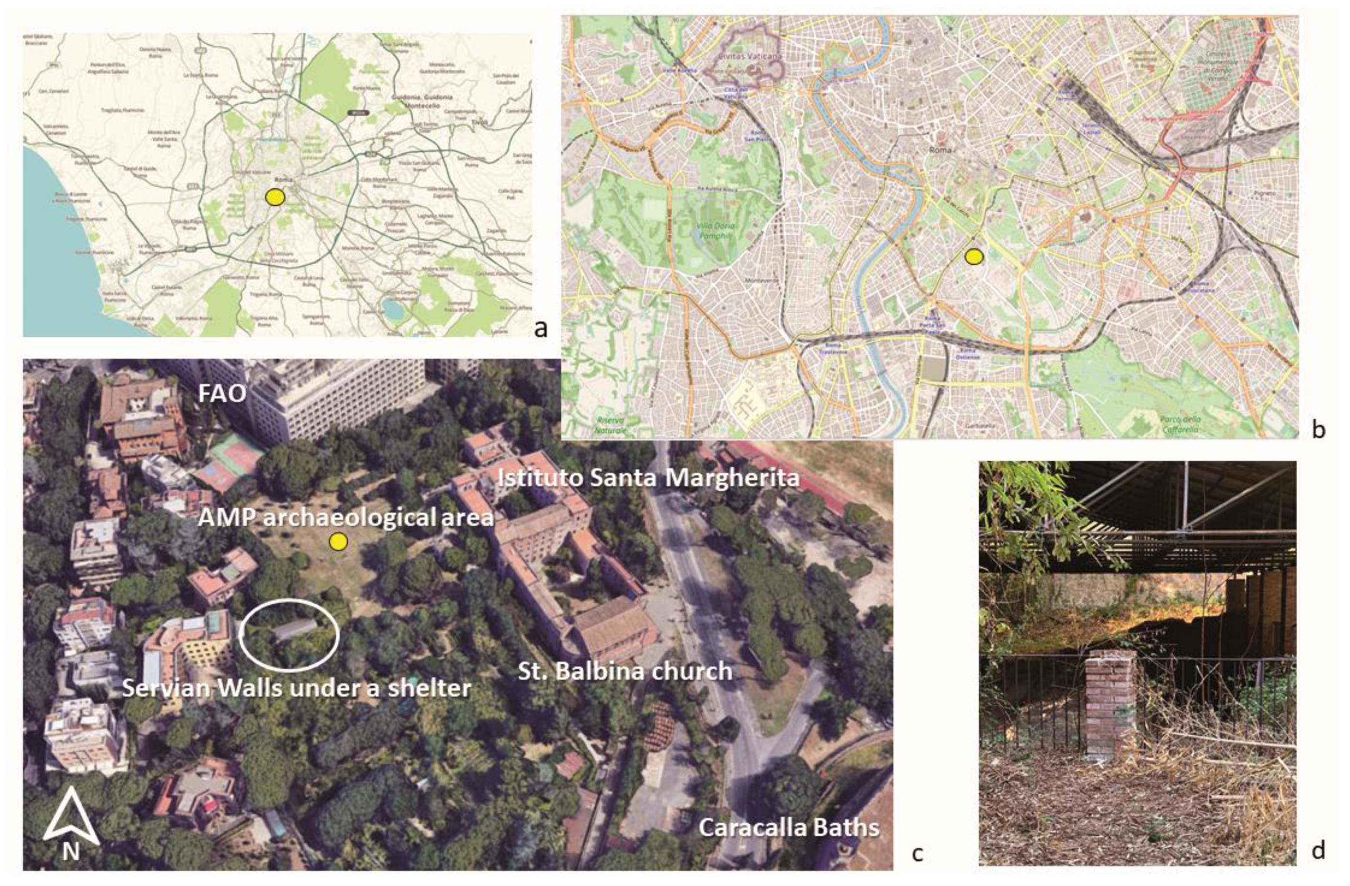
The area under investigation is part of a plateau located on the north-eastern portion of the Roman hill called ‘Little Aventine’ (the Latin
Aventinus Minor) (
Figure 1b). In Antiquity, this summit was named the
saxum and was a strategic point to control the underlying valley of the Circus Maximus and the routes to southern Italy and the Adriatic coast. At the bottom of the
saxum, where the Food and Agriculture Organization (FAO) of the United Nations now stands, the temple of
Bona Dea subsaxana (272 BCE) symbolically protected Romans with its healing rituals [
1,
3,
4].
The open field surveyed by AMP in 2021 was included within the circuit of the Servian Walls, which originally date back to the 6th c. BCE during the Monarchic Period. Pieces of this massive wall dating to the late Republican phase of reconstruction are still visible in the field under a shelter and have also been incorporated within the medieval walls of the later monastery of St. Balbina (
Figure 1c,d). The walls preserved on the
Aventinus Minor are no longer a continuous span as they were partially dismantled when Rome outgrew this early defense circuit. When the city expanded, the hill became populated by various houses, warehouses, bathhouses, and safety structures [
4,
5,
6,
7,
8,
9].
The
saxum itself was inhabited by elite families: the most important house was probably that of L. Fabius Cilo, counted among the closest friends of the emperor Septimius Severus. The medieval church of St. Balbina and the surrounding monastery have likely reused part of the structure of this wealthy residence, as evidenced by a series of walls of
opus reticulatum and
opus latericium, which are still visible within the monastery. This continuity between ancient residential structures and devotional Christian spaces was typical during the early periods of Christianization in Rome [
1,
10,
11,
12,
13,
14].
Meanwhile, the surrounding hill was depopulated during the early medieval period, leaving space for the cultivation of grapes, fruit trees, and greenery surrounding the two main ecclesiastic sites of St. Balbina and St. Saba. It was only in 1871 when Rome became the capital of the new Italian state that a new phase of urbanization began to shape the hill’s contemporary appearance [
1,
15,
16,
17].
1.2. Aventinus Minor Project
The Aventinus Minor Project (AMP) is a community archaeological excavation project focusing on an understudied area in Rome in the modern San Saba neighborhood. AMP has designed a research plan to answer specific academic research questions in collaboration with multiple community partners, including The American University of Rome, St. Stephen’s School (whose campus directly borders on the open field), the Istituto Santa Margherita (the landowners of the field and a Catholic convalescent home), and the Archaeological Superintendency of Rome. AMP’s three main goals include research, pedagogy, and community involvement. We aim to conduct academically rigorous, modern, and scientifically and culturally responsible archaeological research excavation; to teach archaeological theory methodologies to both high school students at St. Stephen’s and the undergraduate and graduate students at The American University of Rome; and to involve the surrounding local community, especially the Istituto Santa Margherita convalescent home and St. Stephen’s, in the research, discovery, and dissemination of their own local history and material culture. Indeed, the involvement of the local community is a valued component of AMP’s approach to the study of the area’s archaeological and social context, and is essential to a thorough and sustainable archaeological project. Since 2020, AMP has involved the local community through a series of bi-lingual (English and Italian) lectures, informational posters, hands-on demonstrations, cultural heritage exhibitions, and community service projects [
18,
19].
2. Materials and Methods
Due to the COVID-19 pandemic, during the summer of 2020, AMP conducted only desktop survey with archival, cartographic, and bibliographic research, recording and investigating ancient landmarks on the Aventinus Minor Hill. Research specifically worked to list the features included on the Capitoline Base (136 CE) and in the Regionary Catalogues (312 CE), ancient primary sources in which various roads and structures in Roman neighborhoods are cataloged. These landmarks were placed into a Geographical Information System (GIS) database to better analyze the contextual relationships of the ancient Roman Aventinus Minor, including, for example, the extent to which past structures have been incorporated into or destroyed by modern buildings.
During the 2021 season, AMP received a three-year excavation permit from the Ministero della Cultura and the Soprintendenza Speciale Archeologia Belle Arti e Paesaggio di Roma. Thanks to an improvement in COVID-19 pandemic conditions, AMP was able to survey, record, and study the Aventinus Minor in person during May and June 2021. Students began by analyzing, drawing, and documenting the walls along Via di S. Balbina, as they appear on Nolli’s 1748 map. Students then georeferenced and researched all of the existing archaeology and landmarks (both ancient and modern) of the Little Aventine. Finally and most importantly, AMP conducted a non-destructive remote sensing survey in the open field adjacent to the basilica of S. Balbina and the Istituto Santa Margherita. The application of a remote sensing approach provides a nuanced understanding of both the landscape of the site as well as the larger context of the surrounding neighborhood.
During the 2021 season, 4-band satellite images (R,G,B, and NiR) were collected. The image used was taken on 28 May 2021 with the SkySat satellite (0.5m resolution) and the aim was to highlight possible evidence buried in the shallow subsurface using the Normalized Difference Vegetation Index (NDVI) calculated according to (1), a dimensionless index that describes the difference between visible and NiR reflectance of vegetation cover and can be used to estimate the density of green on an area of land with particular regards to possible buried archaeological remains [
20,
21,
22,
23].
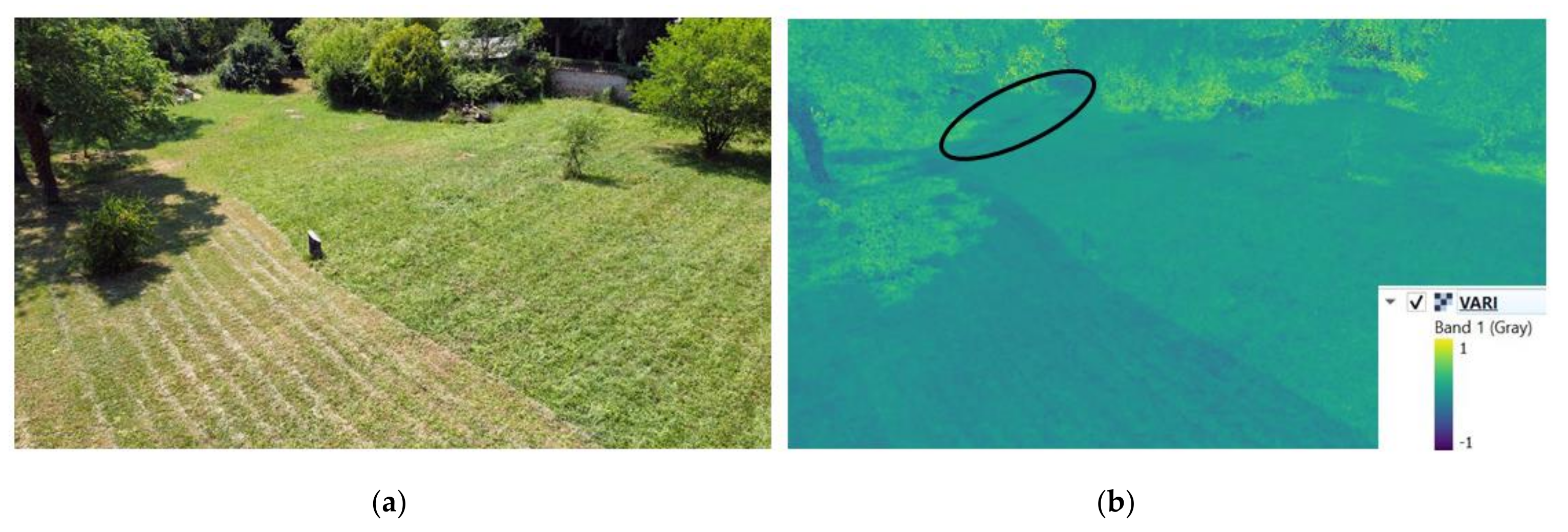
Subsequently, the DJI Mavic Mini drone was used to collect aerial photos with an optical (RGB) sensor to not only detect possible crop marks on the surface, but also to better understand the general position of the surveyed area in relation to the Santa Balbina church and the remains of the Servian Walls. With such imagery, it is also possible to apply another RS tool called Visible Atmospherically Resistant Index (VARI) (2), which is designed and tested to work with RGB sensors. This is a more useful and accurate way to measure plant health than using RGB imagery.
The VARI algorithm uses color correction to minimize reflectance, scattering, and other atmospheric effects to better estimate the fraction of healthy vegetation in an area and it is very useful in both archaeological and forensic investigations to detect remotely buried evidence (such as walls or concealed graves) in a shallow subsurface by enhancing vegetation under strong atmospheric impact while smoothing illumination variations [
22,
24,
25,
26].
Finally, AMP surveyed the site with a bistatic GPR system, which allowed us to view anomalies in the ground up to a maximum depth of about 3m. Specifically, the Noggin
® SmartCart
® (Sensors & Software, Inc., Mississauga, Canada) with 500 MHz antennas was employed. A series of Y-grids were collected in both areas with similar parameters due to the similarities in the soil and dielectric constant conditions (0.5 m interline; Stacking 4; v = 0.80 m/ns using the hyperbola calibration; setting of the zero-time position relative to the ground surface). The data was of good quality, and images were further set to “amplify” the strength of the GPR data signals in both the GPR lines and depth slices. In particular, for both areas, a combination of dewow, migration, envelope (DME), background subtraction, and user gain (start gain 0.5, attenuation 0.8, and maximum between 450) was used. The attenuation value defines the steepness of the gain function. Lower values result in a more gradual slope, while higher values produce steeper slopes. The value slope begins at the start gain value and increases until the maximum gain value (the highest multiplication factor that can be applied to GPR line data) [
27,
28,
29].
3. Results
3.1. Satellite Imagery (NDVI)
The purpose of using the abovementioned satellite image was to check for possible anomalies in the vegetation growth within the area affected by potential buried anomalies and the possible course of the Servian Walls. The use of the NDVI algorithm mentioned above allowed us to analyze the vegetation stress in the area of interest using the NiR band, however without highlighting any evident anomalies in the subsurface (
Figure 2). In addition, this analysis did not highlight any other clear anomalies that might indicate evidence in the shallow subsurface.
3.2. UAV Imagery (VARI)
In contrast to the satellite image, the UAV image revealed interesting anomalies in a specific area of the garden. Using the above-mentioned VARI algorithm, the resulting optical image highlighted an evident discontinuity in the area proposed for the continuation of the Servian Walls (
Figure 3a,b). In
Figure 3b, it is possible to notice the presence of several dark anomalies, most of which already have visible matches on the ground within the UAV image. Only one anomaly (circled in black in
Figure 3b) is unrelated to visible ground patches, and this happens to be exactly where we expect the passage of the walls should be. The advantage of the VARI analysis is that it can also be performed with images that are not satellite or orthorectified but simply taken from a bird’s eye view as in this case. Moreover, the point at which the anomaly is visible in the VARI image has been further georeferenced and correlated using the other analyses mentioned previously.
This evidence has given us the necessary premises to specifically investigate the nature of this anomaly through the use of the GPR.
3.3. GPR
Based on the results of the previous VARI analysis, a series of parallel profiles were collected not only in the specific area investigated but also throughout the rest of the garden to obtain depth slices of the various anomalies in the subsoil.
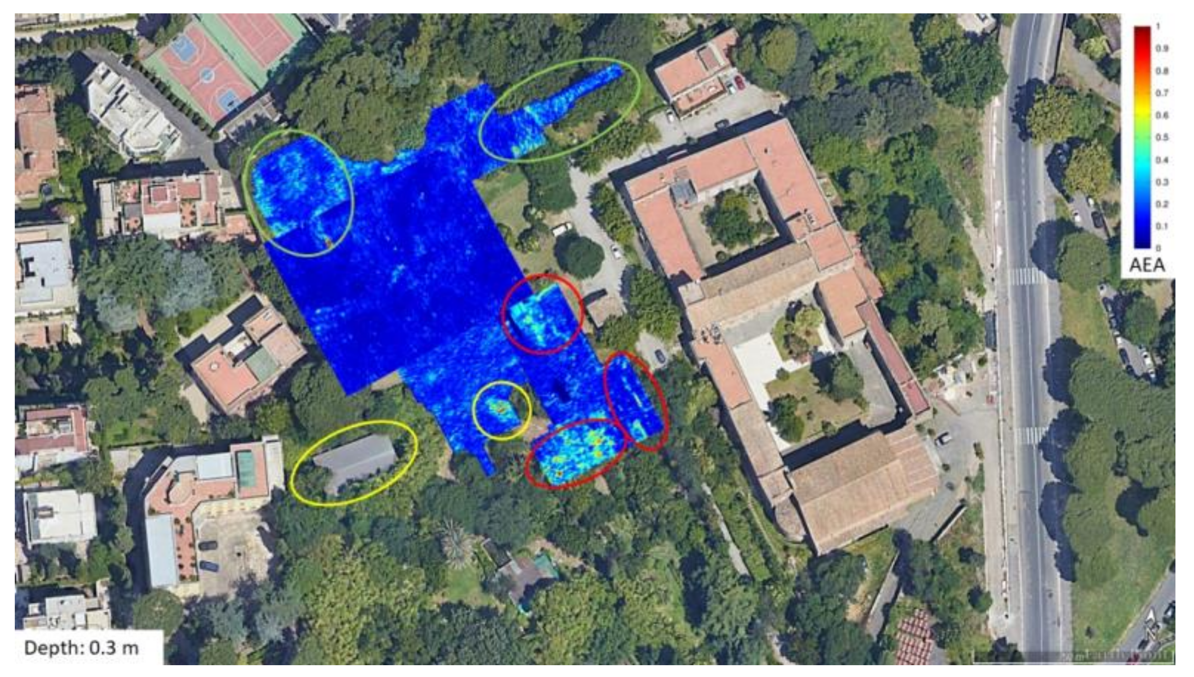
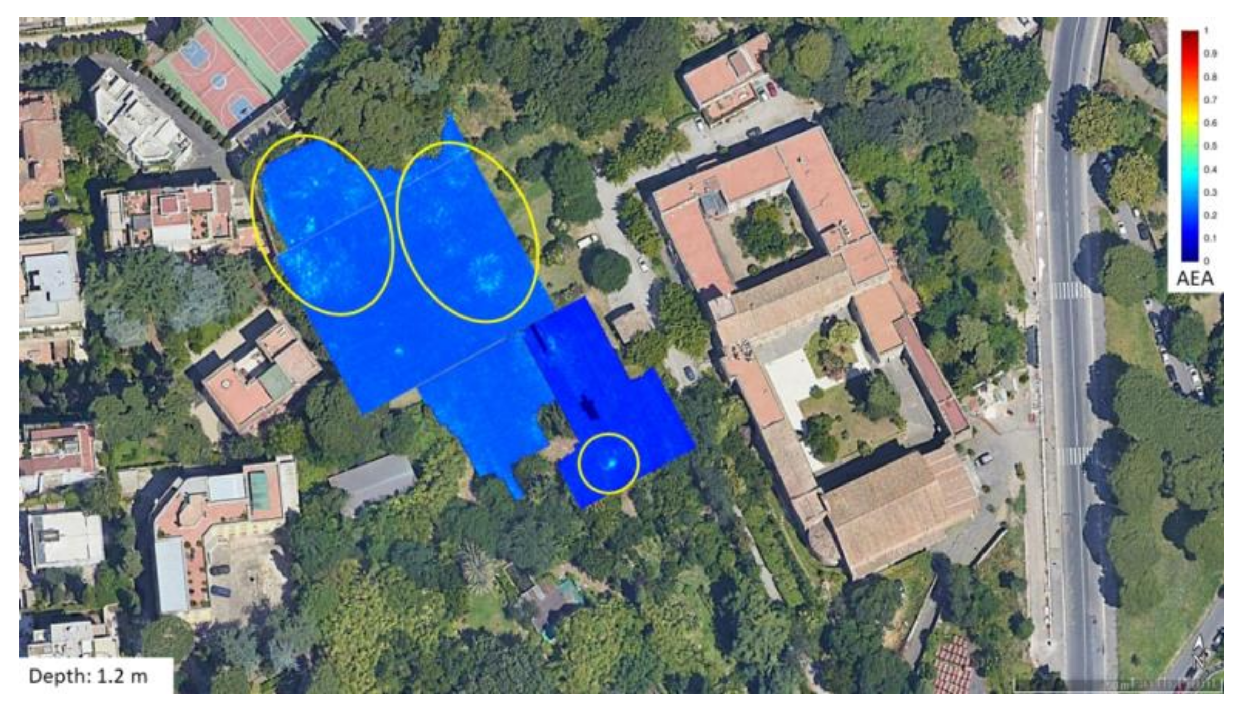
The most interesting find related to the VARI result is an anomaly buried at 0.3 m (
Figure 4). Based on georeferencing of the VARI anomaly and alignment derived from GIS mapping,
Figure 4 shows some interesting correlated features. First, an isolated oval-shape geometry that seems aligned with the direction of the visible remains of the Servian Walls below the shelter (the yellow circles). In addition, other GPR anomalies with fairly regular shapes (circular or elongated) are visible in the northern area of the open field, which cannot be excluded as being of an ancient anthropic nature due to their regular shapes (green circles). Finally, in the part of the garden closest to the Istituto Santa Margherita and the church of Santa Balbina, there are anomalies that, given their orientation and proximity, can be attributed to recent anthropic elements related to the construction of the institute (e.g., water reservoir and sewage system) (red circles).
Considering the known remains of the Servian Walls and their alignment, there is a possibility that this GPR evidence corresponds with a portion of this wall. The reconstruction of this correct alignment was provided thanks to the GIS (
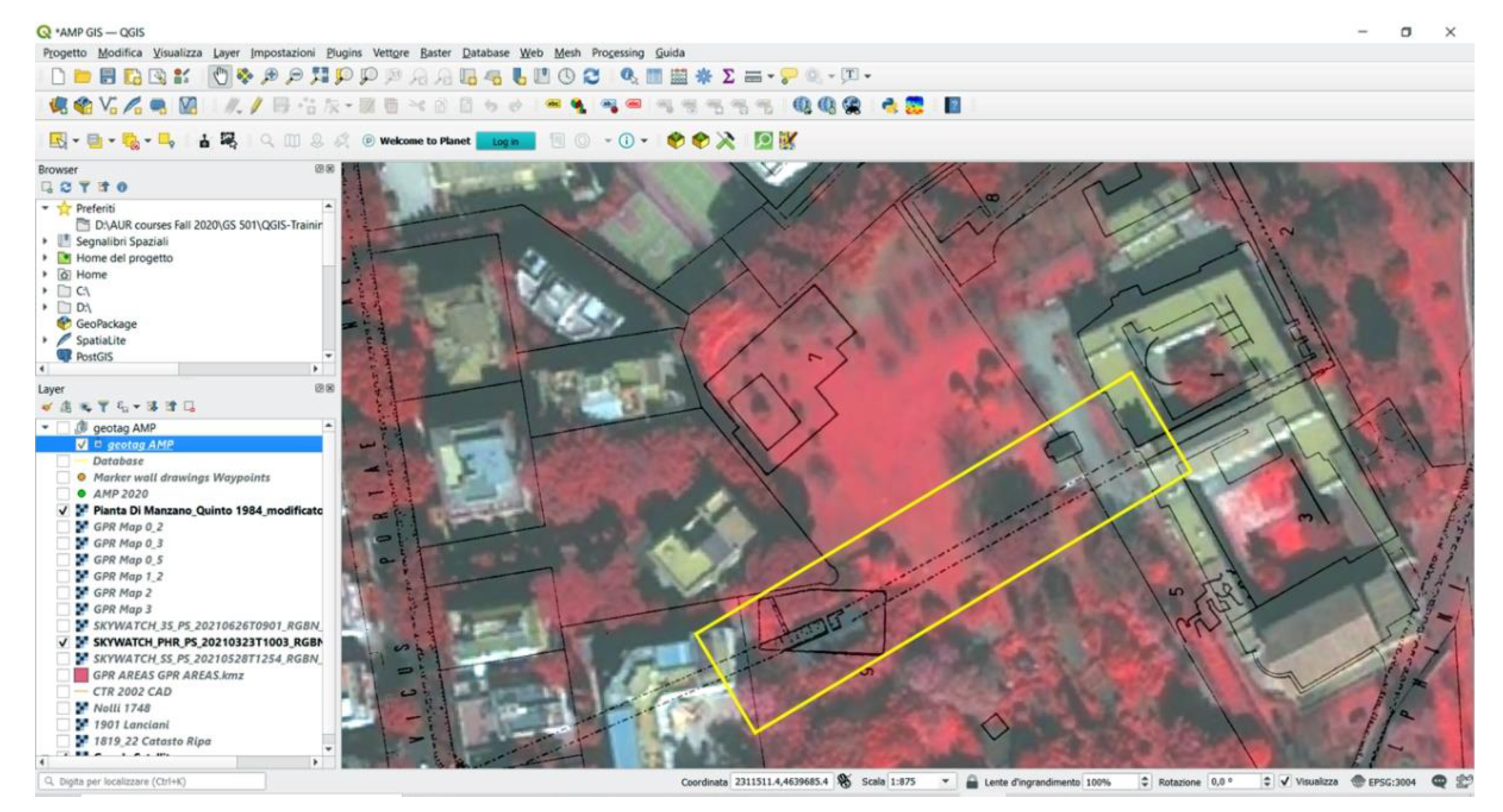
Figure 5). This system allows us to collect different sources of information (from ancient cartography to modern surveys), overlapping different layers, and giving them a geographic coordinate.
The next GPR depth slice of research interest is at 1.2 m.
Figure 6 shows a series of GPR anomalies which, given their depth and geometry, could be of archaeological significance. Most of them are concentrated in the northern and central part of the garden and appear to have a circular shape. However, there is an isolated anomaly in the southern sector of the garden to be noted as a possible top of a deeper structure.
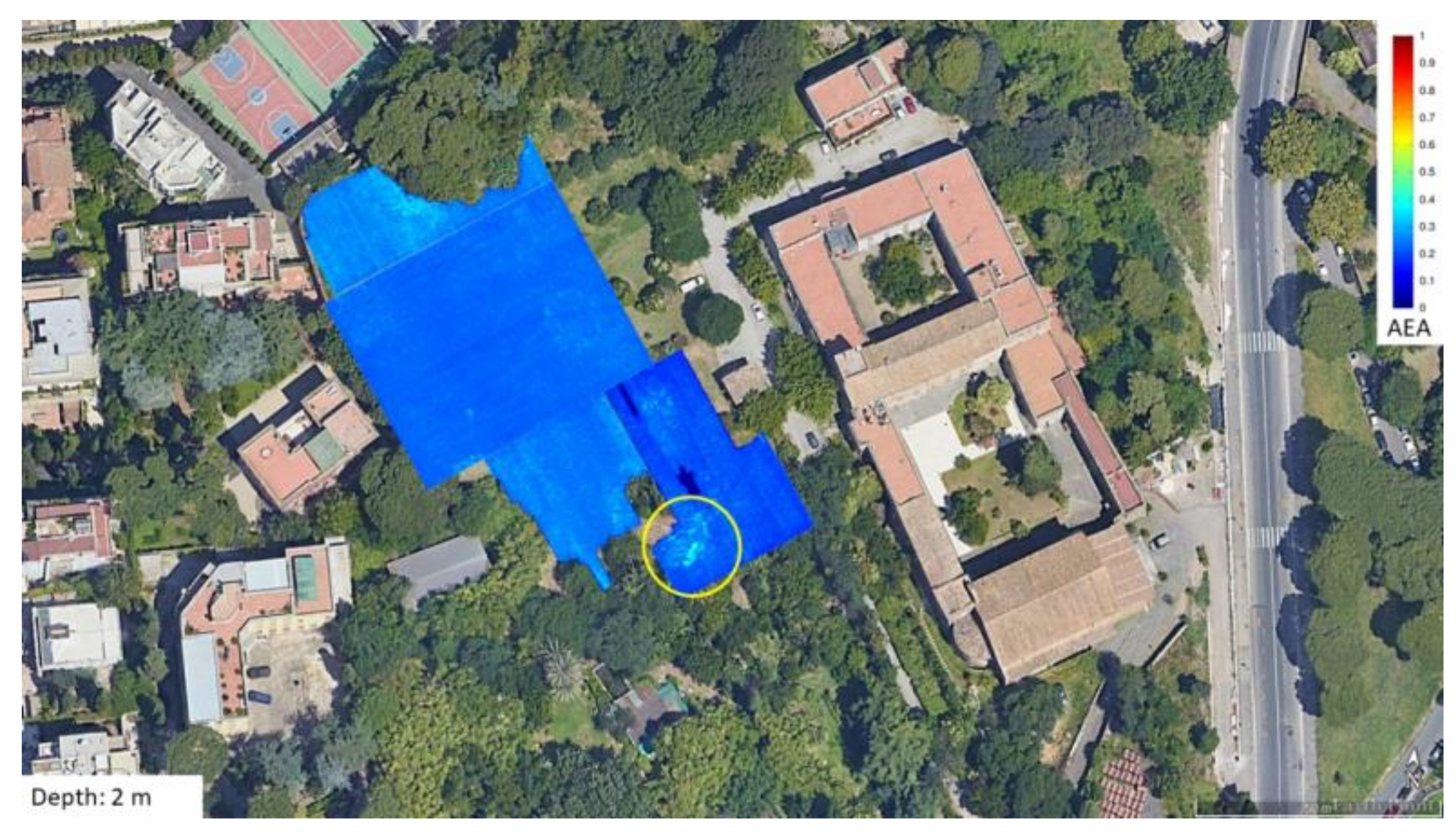
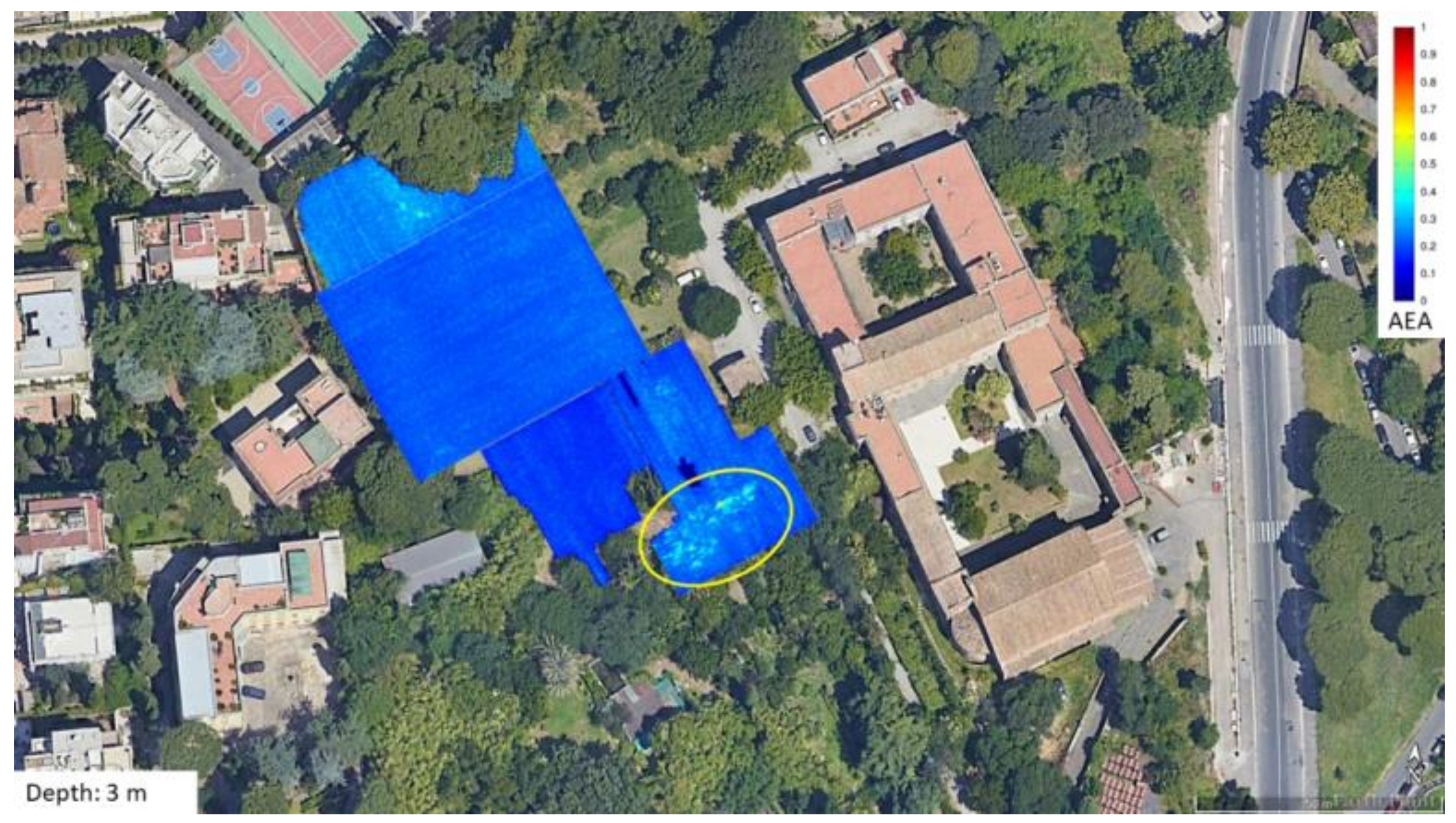
Finally, the last two depth maps at 2 m and 3 m (
Figure 7 and
Figure 8, respectively) also show interesting anomalies, albeit fewer in number, probably related to those noted in the previous
Figure 6. In particular, the aforementioned isolated GPR anomaly in the southern part of the garden now appears to be deepening and enlarging into something that has all the appearance of a buried ancient manmade structure.
4. Discussion
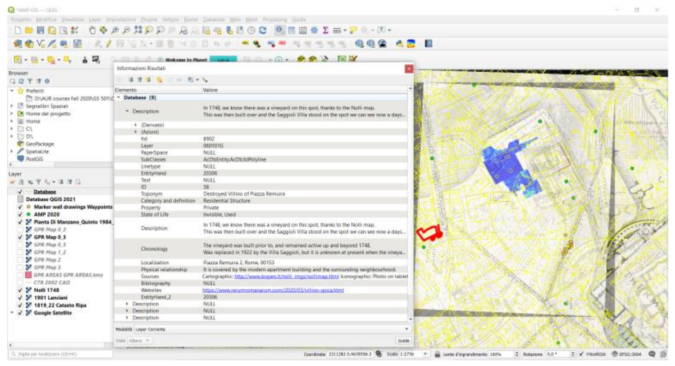
The GPR anomalies revealed by the survey illustrate that this area is potentially rich in buried structures, as reported in literary sources. A correct and georeferenced mapping of this evidence leads to a more nuanced understanding of the urban territory of the Little Aventine. The collection of this RS data helped to implement the existing GIS (
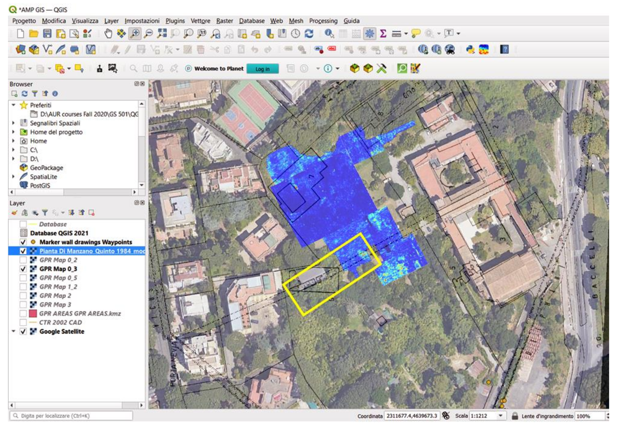
Figure 9). One of the most important elements of archaeology is context, which includes all information associated with an archaeological element. Modern archaeological digs try to preserve and record an object’s context as much as possible using a combination of several different strategies. To that end, we used the concept of stratigraphic sequencing to document the various GIS layers found in our different surveys. Together with the management of data from archival research, ancient and modern cartography, it was also possible to update the GIS data with GPR maps and remote sensing images acquired during the 2021 season.
This tool represents a powerful method to visualize in a correct and georeferenced way every single element, both visible (like the portion of Servian Walls already excavated) and “invisible” (like the anomalies brought to light by the VARI algorithm and the GPR). Thanks to the intrinsic nature of this platform, it is possible not only to update the archaeological map of the area but also and above all to plan in a precise and accurate manner the following season (Summer 2022), which will feature ground truthing through archaeological excavation as the main focus.
In the future, these promising results will be included in the largest GIS project in Rome: the SITAR (Sistema Informativo Archeologico di Roma), which brings together all of the results of archaeological research carried out within the area of Rome’s Capitoline Hill [
30,
31]. This will allow a wider collaboration between different researchers and a better knowledge of the urban archaeological landscape.
5. Conclusions
Remote sensing was a very important resource in the design of the Aventinus Minor Project, as it offered the possibility of assessing the archaeological potential of a central, though under investigated, area of Rome in a timely manner. The main aim of these preliminary investigations was to answer questions of urban archaeology typical of the area by accurately reconstructing connections and linking hitherto isolated archaeological manmade structures.
AMP’s plan of investigation required continuous research and also constant adaptation of initial plans due to the pandemic crisis. Despite this, the outcome has been extremely auspicious and sets interesting premises for ground truthing through archaeological excavation to be carried out next season (Summer 2022). Through archaeological excavation, we will be able to verify the results of the remote sensing survey detailed here. Future publications will compare our current hypotheses with the material obtained through ground truthing.
The potential of the RS results, combined with their usability, position AMP as a promising research project with firm bases both within the territory and the local community. However, beyond the quality and usability of the scientific results, AMP’s further novelty lies in having been able to successfully carry out its multi-faceted work by including several community collaborators within the complex urban environment of Rome, one of the world’s capital archaeological cities.
Author Contributions
Conceptualization, E.W., G.F. and P.M.B.; methodology, E.W., G.F. and P.M.B.; software, P.M.B.; validation, E.W., G.F. and P.M.B.; formal analysis, P.M.B.; investigation, E.W., G.F. and P.M.B.; resources E.W., G.F. and P.M.B.; data curation, E.W., G.F. and P.M.B.; writing—original draft preparation, E.W., G.F. and P.M.B.; writing—review and editing, E.W., G.F. and P.M.B.; visualization, E.W., G.F. and P.M.B.; supervision, E.W., G.F. and P.M.B.; project administration, E.W., G.F. and P.M.B.; funding acquisition, E.W. All authors have read and agreed to the published version of the manuscript.
Funding
The Aventinus Minor Project is entirely donor-funded. Donors are affiliated with The American University of Rome and the Saint Stephen’s School. AUR is currently looking for additional funding. To support AMP, visit our Giving Page.
Institutional Review Board Statement
Not applicable.
Informed Consent Statement
Not applicable.
Data Availability Statement
The data are available in the Italian Ministry of Culture database with limited access as requested by law.
Acknowledgments
The AMP project has received the legal permits from the Italian Ministry of Culture: Concessione DG-APAB, prot. 20027, 10/06/2021, Decreto 609. The authors would like to acknowledge the help and support of the Soprintendenza Speciale Archeologia Belle Arti e Paesaggio di Roma represented by Roberto Narducci and Letizia Rustico, the American University of Rome, the Saint Stephen’s School, the Istituto Santa Margherita, and all the AUR undergrad and grad students involved in this project. Finally, the authors would also like to express their special thanks to Federica Mazzarelli.
Conflicts of Interest
The authors declare no conflict of interest.
References
- Narducci, R.; Rustico, L. L’Aventinus Minor. Un Paesaggio Urbano Tra Archeologia e Storia. In Studi e Scavi sull’Aventino 2003–2015; Quasar: Rome, Italy, 2018; pp. 81–97. [Google Scholar]
- Barone, P.M.; Wueste, E.; Hodges, R. Remote Sensing Materials for a Preliminary Archaeological Evaluation of the Giove Countryside (Terni, Italy). Remote Sens. 2020, 12, 2023. [Google Scholar] [CrossRef]
- Bianchi, L.V. Indagini di topografia urbana: La sommità settentrionale dell’Aventino minore. Studi Rom. 2019. [Google Scholar]
- Taviani, M. Indagini Della Soprintendenza Archeologica di Roma Nella Zona Dell’Aventino (1998–2000). Bull. Comm. Archeol. Comunale Roma 2002, 103, 197–200. [Google Scholar]
- Bevilacqua, M.; Cavallero, D.G. L’Aventino dal Rinascimento a Oggi. Arte e Architettura; Artemide: Roma, Italy, 2010; ISBN 978-88-7575-107-4. [Google Scholar]
- Bernard, S.G. Continuing the debate on Rome’s earliest circuit walls. Pap. Br. Sch. Rome 2012, 80, 1–44. [Google Scholar] [CrossRef]
- Bianchi, L.; Coppola, M.R.; Mutarelli, V. Il Complesso Di S. Balbina Sull’Aventino Minore: Note Topografiche e Monumentali. Palladio Riv. Stor. Archit. Restauro 2014, 27, 5–42. [Google Scholar]
- Narducci, R.; Taviani, M. La Sistematizzazione dei Dati dell’Aventino. Prospettive di Ricerca. Available online: http://www.archcalc.cnr.it/supplements/id_sup.php?id=oai:http://www.archcalc.cnr.it/supplements/A_C_oai_Archive_sup.xml:841 (accessed on 9 November 2021).
- Capoferro, A.; Mignone, L.M.; Quaranta, P. Studi e Scavi sull’Aventino 2003–2015; New ed.; Quasar: Rome, Italy, 2018; ISBN 978-88-7140-724-1. [Google Scholar]
- Quinto, R. Interventi Edilizi Sull’Aventino (1930–1970). Boll. Archeol. 1990, 5–6, 237–251. [Google Scholar]
- Di Manzano, P.; Quinto, R. Regione 12. Area Di S. Balbina. Boll. Comm. Archeol. Comunale 1984, 89, 68–81. [Google Scholar]
- Delogu, C. Archeologia e Multimedialità: I Siti dell’Aventino e del Testaccio; Iuno Edizioni: Rome, Italy, 2011. [Google Scholar]
- D’Amelio, M.G. Le pendici dell’aventino in una perizia di carlo fontana: Archeologia e meccanica pratica. In L’Aventino dal Rinascimento a Oggi. Arte e Architettura; Artemide: Roma, Italy, 2021. [Google Scholar]
- Travaglini, C.M.; Lelo, K. Roma nel Settecento. Immagini e Realtà di una Capitale Attraverso la Pianta di G. B. Nolli; Ediz. illustrata; CROMA: Roma, Italy, 2013; ISBN 978-88-8368-132-5. [Google Scholar]
- Coarelli, F. Rome and Environs: An Archaeological Guide, Updated Edition; University of California Press: Berkeley, CA, USA, 2014; ISBN 978-0-520-28209-4. [Google Scholar]
- Bevilacqua, M. Nolli e piranesi all’aventino. In L’Aventino Dal Rinascimento a Oggi. Arte e Architettura; Bevilacqua, M., Gallavotti Cavallero, D., Eds.; Artemide: Rome, Italy, 2010; pp. 120–135. [Google Scholar]
- Di Cola, V.; Modolo, M.; Piro, S. Via G. Baccelli. Rilievo Delle Strutture Archeologiche e Indagini Geofisiche. Bull. Della Comm. Archeol. Comunale Roma 2016, 117, 294–301. [Google Scholar]
- Wueste, E.A. Aventinus Minor Project: April 2021 Newsletter. Available online: https://www.academia.edu/47418773/Aventinus_Minor_Project_April_2021_newsletter (accessed on 9 November 2021).
- Wueste, E.A. Aventinus Minor Project: November 2021 Newsletter. Available online: https://www.academia.edu/61445367/Aventinus_Minor_Project_November_2021_newsletter (accessed on 9 November 2021).
- Weier, J.; Herring, D. Measuring Vegetation (NDVI & EVI). Available online: https://earthobservatory.nasa.gov/features/MeasuringVegetation (accessed on 9 November 2021).
- Lasaponara, R.; Masini, N. Identification of Archaeological Buried Remains Based on the Normalized Difference Vegetation Index (NDVI) from QuickBird Satellite Data. Geosci. Remote Sens. Lett. IEEE 2006, 3, 325–328. [Google Scholar] [CrossRef]
- Rocke, B.; Ruffell, A.; Donnelly, L. Drone Aerial Imagery for the Simulation of a Neonate Burial Based on the Geoforensic Search Strategy (GSS). J. Forensic Sci. 2021, 66, 1506–1519. [Google Scholar] [CrossRef] [PubMed]
- Agapiou, A. Enhancement of Archaeological Proxies at Non-Homogenous Environments in Remotely Sensed Imagery. Sustainability 2019, 11, 3339. [Google Scholar] [CrossRef] [Green Version]
- Limongiello, M.; Gujski, L.; De Vita, C. Analysis of RGB Images to Enhance Archaeological Cropmark Detection: The Case Study of Nuceriola, Italy; Franco Angeli s.r.l.: Milano, Italy, 2020. [Google Scholar]
- Ronchi, D.; Limongiello, M.; Barba, S. Correlation among Earthwork and Cropmark Anomalies within Archaeological Landscape Investigation by Using LiDAR and Multispectral Technologies from UAV. Drones 2020, 4, 72. [Google Scholar] [CrossRef]
- Gitelson, A.A.; Kaufman, Y.J.; Stark, R.; Rundquist, D. Novel Algorithms for Remote Estimation of Vegetation Fraction. Remote Sens. Environ. 2002, 80, 76–87. [Google Scholar] [CrossRef] [Green Version]
- Barone, P.M. Understanding Buried Anomalies: A Practical Guide to GPR; LAP Lambert Academic: Sunnyvale, CA, USA, 2016; ISBN 978-3-659-93579-4. [Google Scholar]
- Persico, R. Introduction to Ground Penetrating Radar: Inverse Scattering and Data Processing; New ed.; IEEE: Hoboken, NJ, USA, 2014; ISBN 978-1-118-30500-3. [Google Scholar]
- Jol, H.M. Ground Penetrating Radar Theory and Applications; Elsevier: Amsterdam, The Netherlands, 2009. [Google Scholar]
- Serlorenzi, M. Accessibilità e diffusione del dato archeologico: l’Esperienza del SITAR. Archeol. Calcolatori 2018, 29, 31–40. [Google Scholar] [CrossRef]
- SITAR—Sistema Informativo Territoriale Archeologico di Roma. 2020. Available online: https://www.archeositarproject.it/ (accessed on 7 January 2022).
| Publisher’s Note: MDPI stays neutral with regard to jurisdictional claims in published maps and institutional affiliations. |
© 2022 by the authors. Licensee MDPI, Basel, Switzerland. This article is an open access article distributed under the terms and conditions of the Creative Commons Attribution (CC BY) license (https://creativecommons.org/licenses/by/4.0/).


