
Assimilation of Satellite-Derived Soil Moisture and Brightness Temperature in Land Surface Models: A Review


 , and
, and
Abstract
:1. Introduction
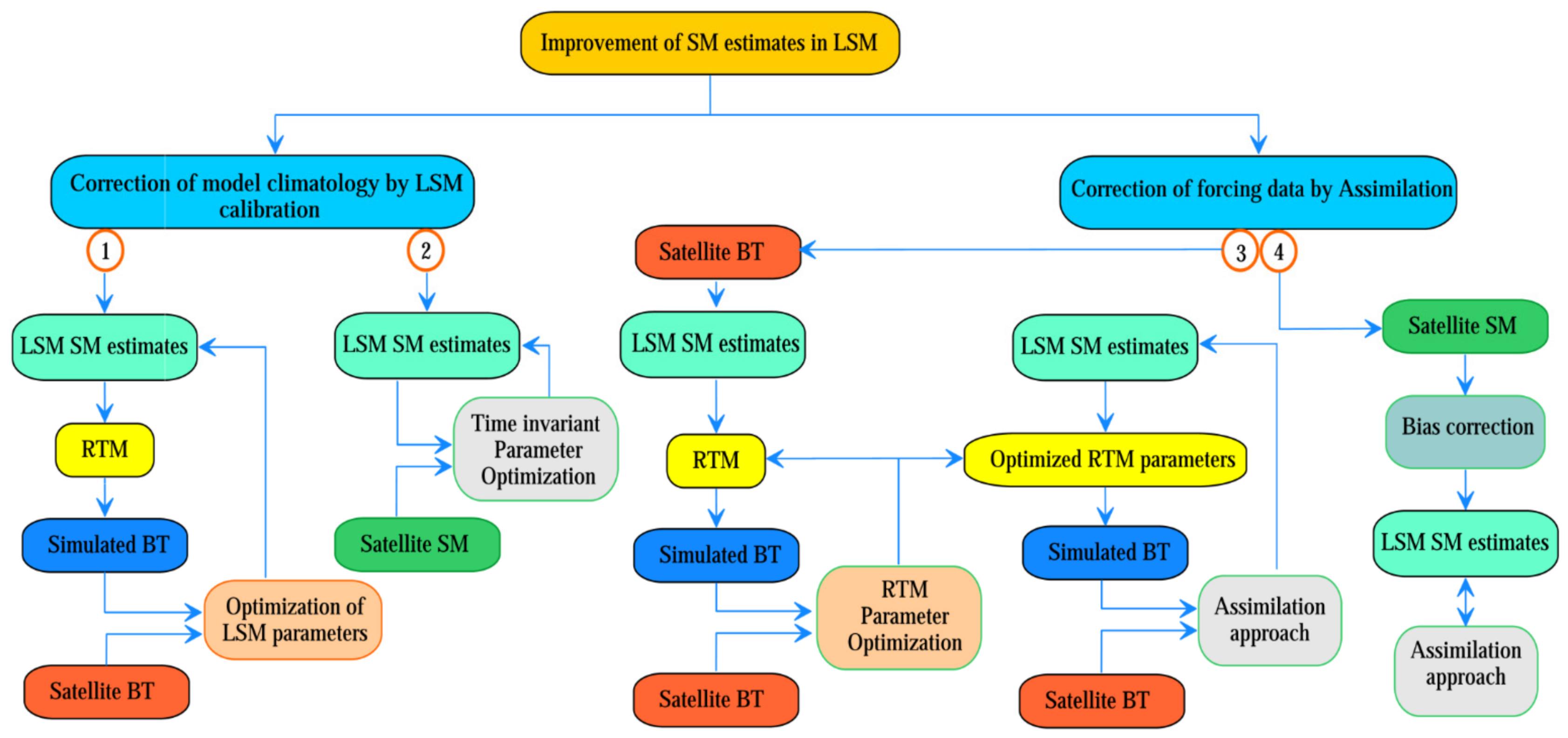
2. Procedures for the Improvement of SM in LSMs
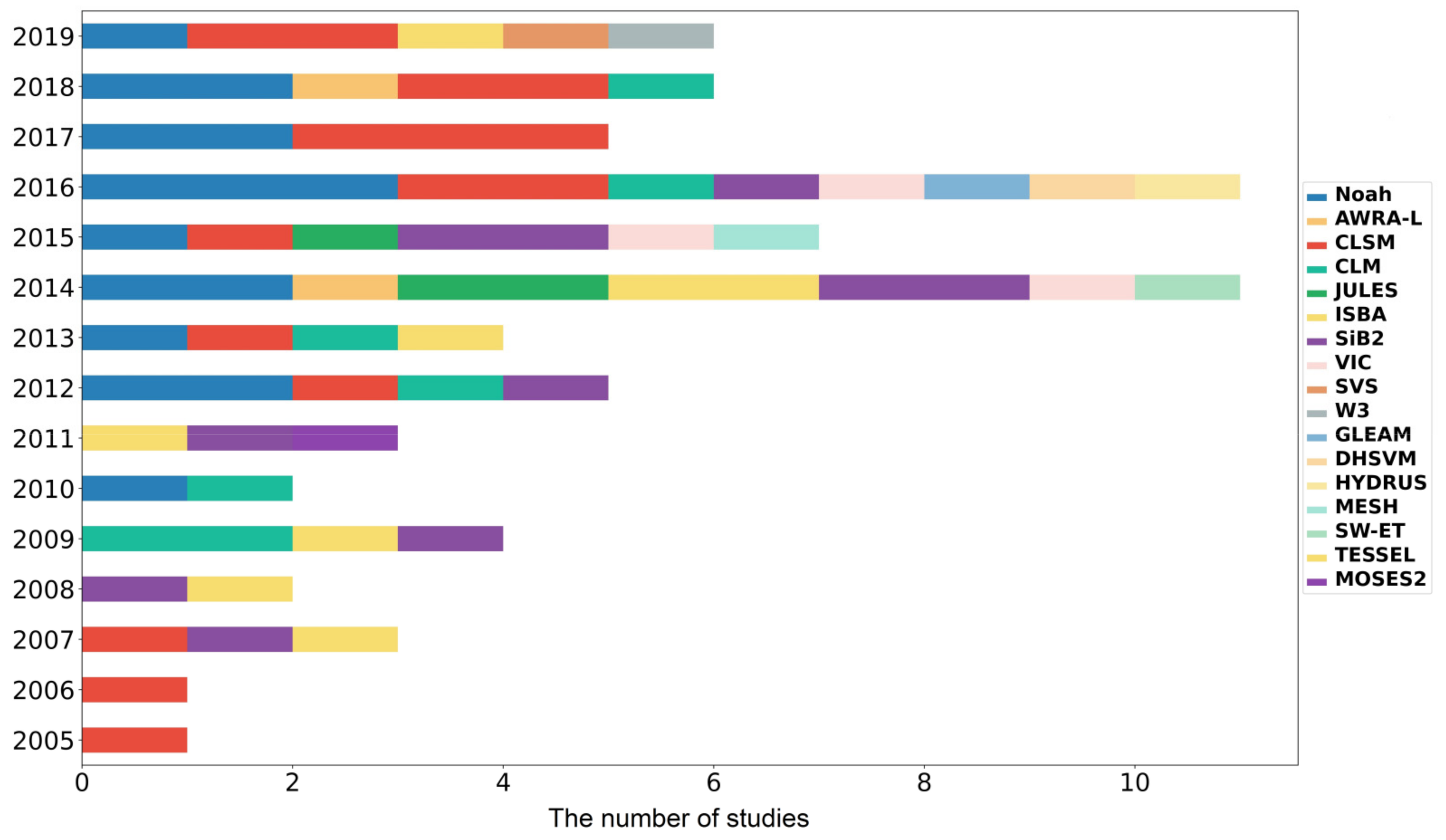
2.1. Land Surface Models
2.2. Uncertainties in LSMs, RTM, and Satellite BT and SM Products
2.2.1. LSMs
2.2.2. RTM
2.2.3. Satellite Data
- SM retrieval approaches. Different strategies and simplifications applied for parameterization of RTMs and soil dielectric mixing models in SM retrieval. As stated in [54,55], most of the SM retrieval algorithms used Ƭ-ω zero-order RTM as the baseline. The major difference between these approaches originates from their parameterizations and estimation of vegetation optical depth. The modeling of roughness, soil, and canopy temperatures, vegetation structure and its optical depth, and atmospheric effects are the most significant factors in SM retrieval. Choosing between effective single or multiple scattering albedo, single or double polarization, static or dynamic roughness coefficients, and single- or multi-angle satellite observations, the applied frequency and ancillary data make the algorithms complex and define the quality of SM products. Moreover, as discussed in [54], the selection of mixing dielectric modeling is another critical issue that needs to be regarded when using SM products and evaluating assimilation results.
- The time of satellite orbital pass. Some studies have investigated the accuracy of the SM products of a sensor at different acquisition times. For example, Martens et al. [58] and Yee et al. [59] showed that ascending SMOS data (about 6:00 a.m.) were more accurate than the descending pass (about 6:00 p.m.). However, Jing et al. [60] maintained that the descending pass of SMOS performed better than the ascending pass. In [17,61], it was stated that ASCAT SM data from the descending pass (9:30 a.m.) have more accuracy than the ascending one (9:30 p.m.). Jing et al. [60] noted that the AMSR-E ascending (1:30 p.m.) product was better than the AMSR-E descending (1:30 a.m.) product. Yee et al. [59] stated that AMSR2 X-band products have better performance in evening overpasses (1:30 pm) in contrast with morning overpasses (1:30 a.m.). As stated in [62], it is expected that night time or early morning SM products be more accurate due to: (a) assumed temperature equilibrium between soil and vegetation canopy in the SM retrieval modeling [63] and (b) expected minimum of Faraday rotations during the night [64,65]. However, as indicated above in some studies, other revisit times showed more accuracy, which can be attributed to other factors [62]. These are: (a) Radio Frequency Interference (RFI) contamination in some time periods and (b) diurnal variability of surface conditions such as water in vegetation. Therefore, it is expected that the accuracy of SM products in different acquisition times be checked in the study area before conducting an assimilation study.
- Land cover. The vegetation coverage and type affect the SM retrieval, especially at higher frequencies. In [17,61], it was reported that X and C bands are opaque in dense forests and shrubs with green vegetation fractions of more than 0.5. Other land covers, such as frozen ground, snow cover, water body areas (e.g., flooded areas, rivers, wetlands, lakes, precipitation at the time of satellite passes), steep topography (e.g., rocks), urban area, and heavily forested areas [66] would decrease the quality flag of data recording and, as a result, reduce the available data for assimilation.
- Temperature limitation. Due to the freezing temperature, currently, no reliable satellite-derived SM product is available for low-temperature latitudes and snow covers [67].
- Temporal resolution. The higher the temporal resolution, the more accurate SM temporal dynamics (e.g., caused by irrigation) can be retrieved. Yin et al. [68] proposed that SMOPS products (as combined products) have a higher temporal resolution, which can capture SM dynamics with more detail.
- Spatial resolution. The low spatial resolution of passive microwave sensors, the mismatch between the LSM and satellite spatial resolutions, and the unmolded sub-pixel heterogeneity (mixed land covers mentioned in item 3, land cover, within a pixel) could increase the errors. Downscaling the SM products can be a solution, but the accuracy of downscaling depends on applied ancillary data, downscaling the method and accuracy of in situ measurements, which needs to be analyzed [69]. Therefore, in some cases, it may bring forth lower results. For example, Lievens et al. [70] compared the performance of downscaled SM (by MODIS thermal data) with coarse resolution and showed that downscaling could not provide better results.
- Polarization. Vertical and horizontal polarization might not retrieve the same BTs; vertical polarization BTs are less sensitive to vegetation heterogeneity and roughness than horizontal polarization while they are more sensitive to SM [4,70,71]. Tian et al. [26] showed that the horizontal polarization BTs from AMSR-E have lower temporal variability than the vertical, which can make them less suitable for assimilation experiments. The role of incidence angle could make the problem more complex; Lievens et al. [70] showed that horizontal polarization with incidence angle less than 42.5 degrees could provide better results than in combination with vertical polarization and multi-angle observations (with SMOS sensor). They stated that it could be attributed to the correlation between dual-polarization and multi-angle observations. The higher sensitivity of horizontal polarization to SM and the lower sensitivity of vertical polarization to vegetation and roughness are issues that require more research to find out the weight of each one of these characteristics.
- Dynamic drying rate. The drying rate of estimated SMs in LSMs could be different from satellite-derived SMs. Shellito et al. [72] compared the drying rates of SMAP and those simulated by Noah and showed that the drying SSM from SMAP is faster than Noah simulations. They also stated that when SM content (Noah and SMAP SM contents are linearly related) is high, potential evaporation is high, vegetation cover is low, and SMAP drying is the fastest. They reported that the effect of vegetation on the Noah model is simplified and is less than SMs retrieved by SMAP.
2.3. Calibration of LSM and RTM Parameters
2.4. Bias Correction in SM Assimilation
2.5. Applied Approaches for Assimilation of SM and BT in LSMs
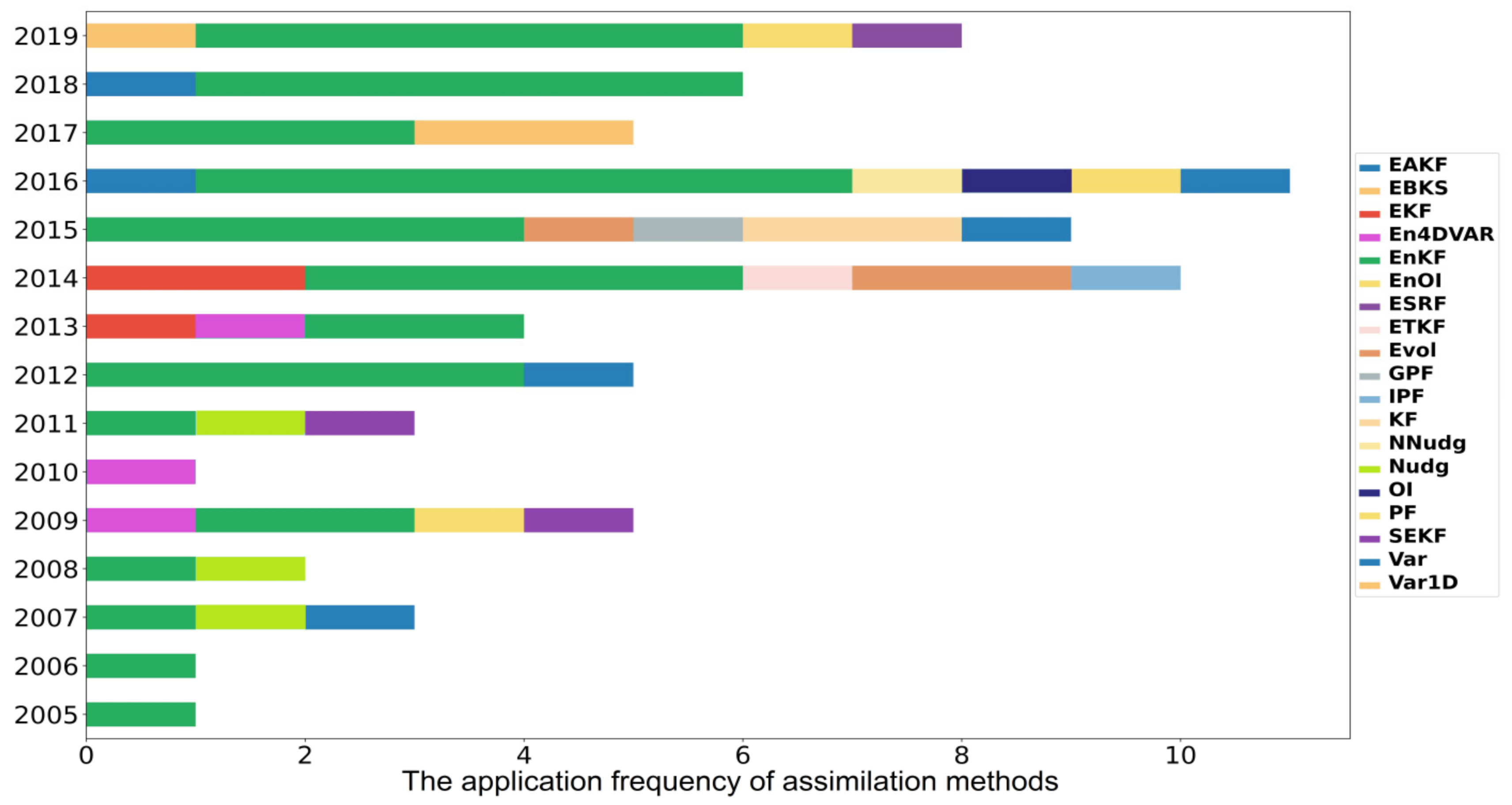
2.5.1. Recruitment of Assimilation Methods
2.5.2. Comparison of Assimilation Methods in Improvement of SM Estimates
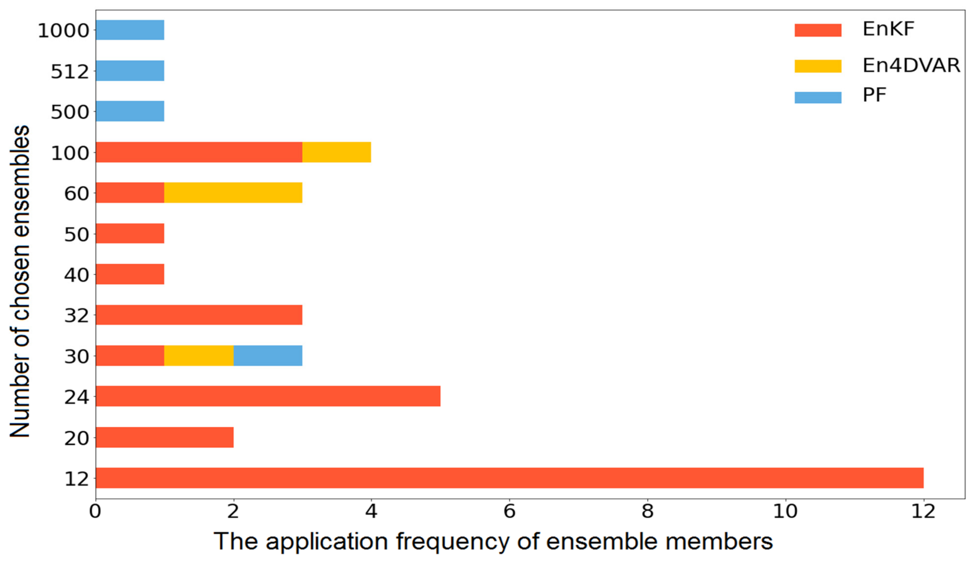
2.5.3. Optimal Ensemble Size in EnKF and PF
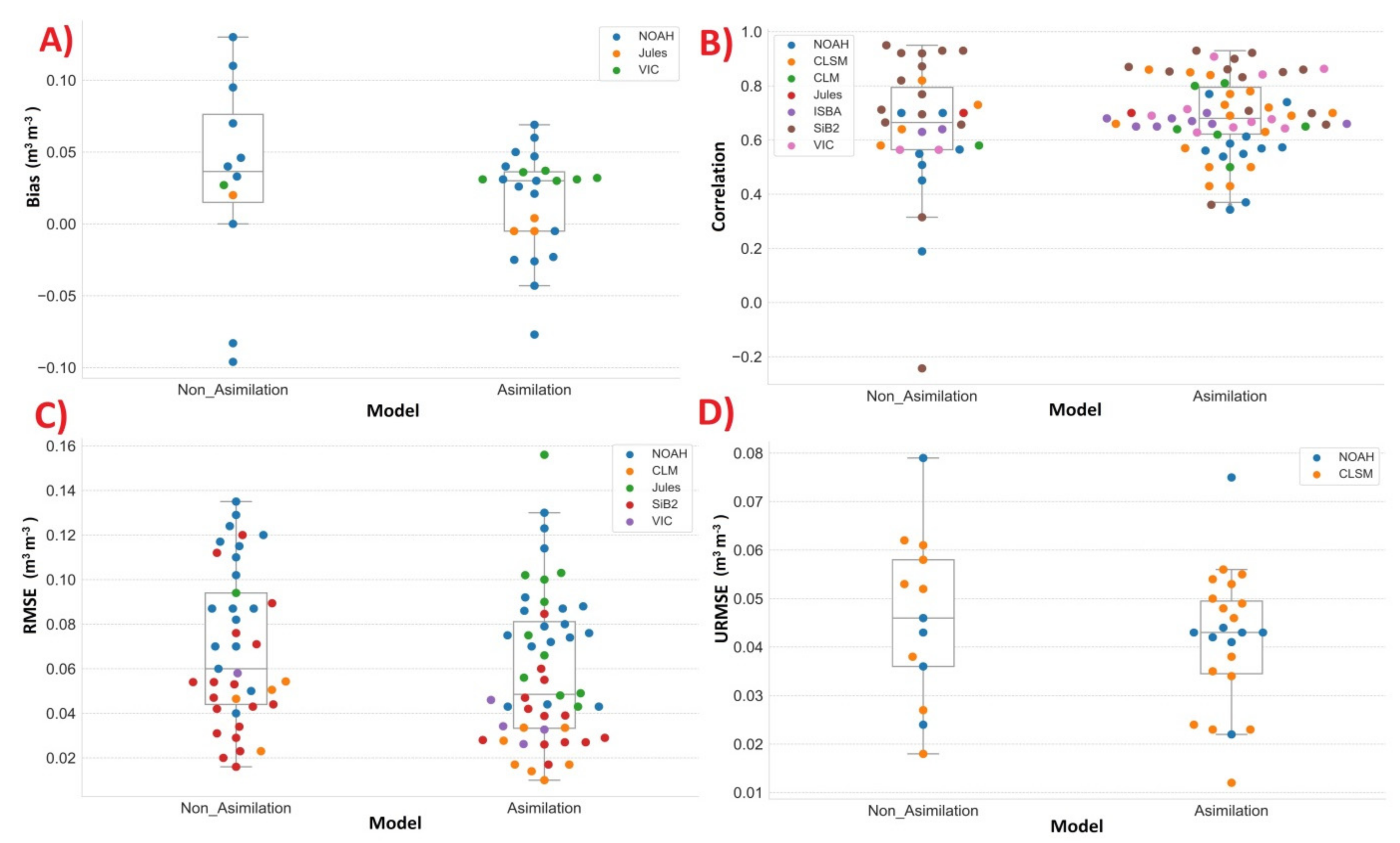
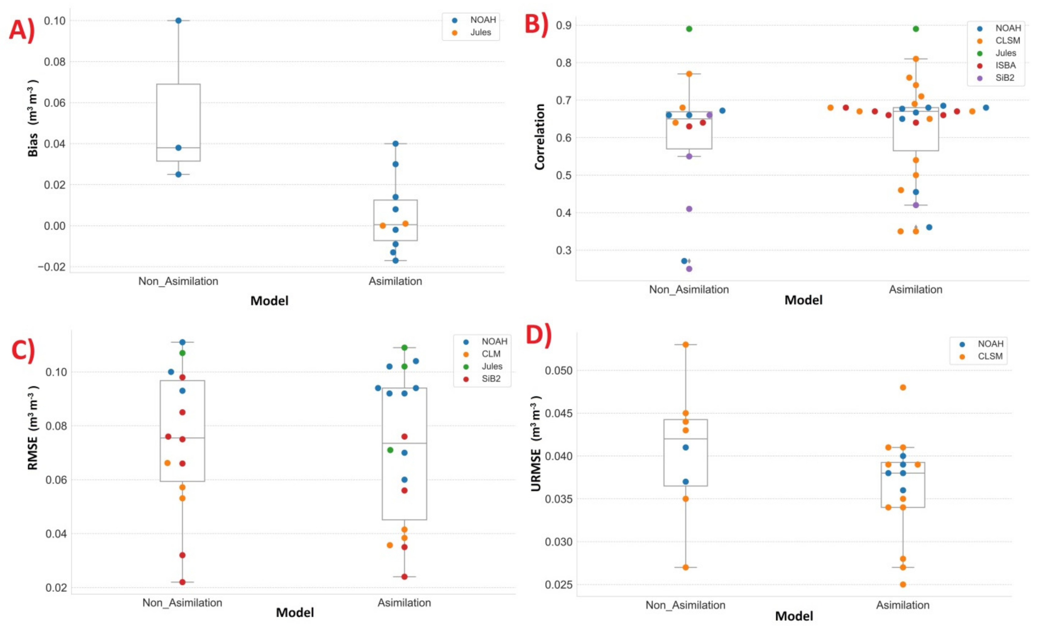
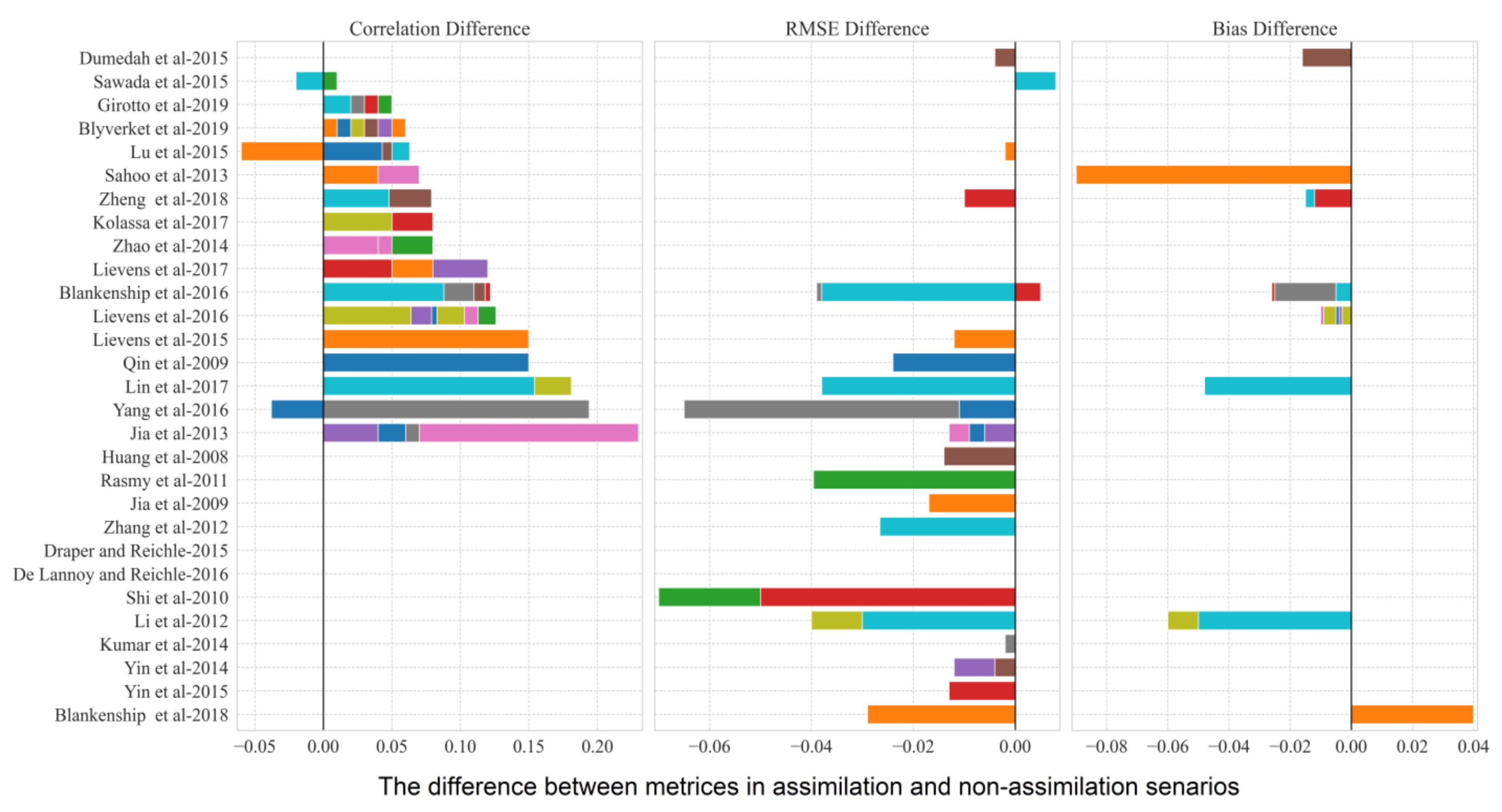
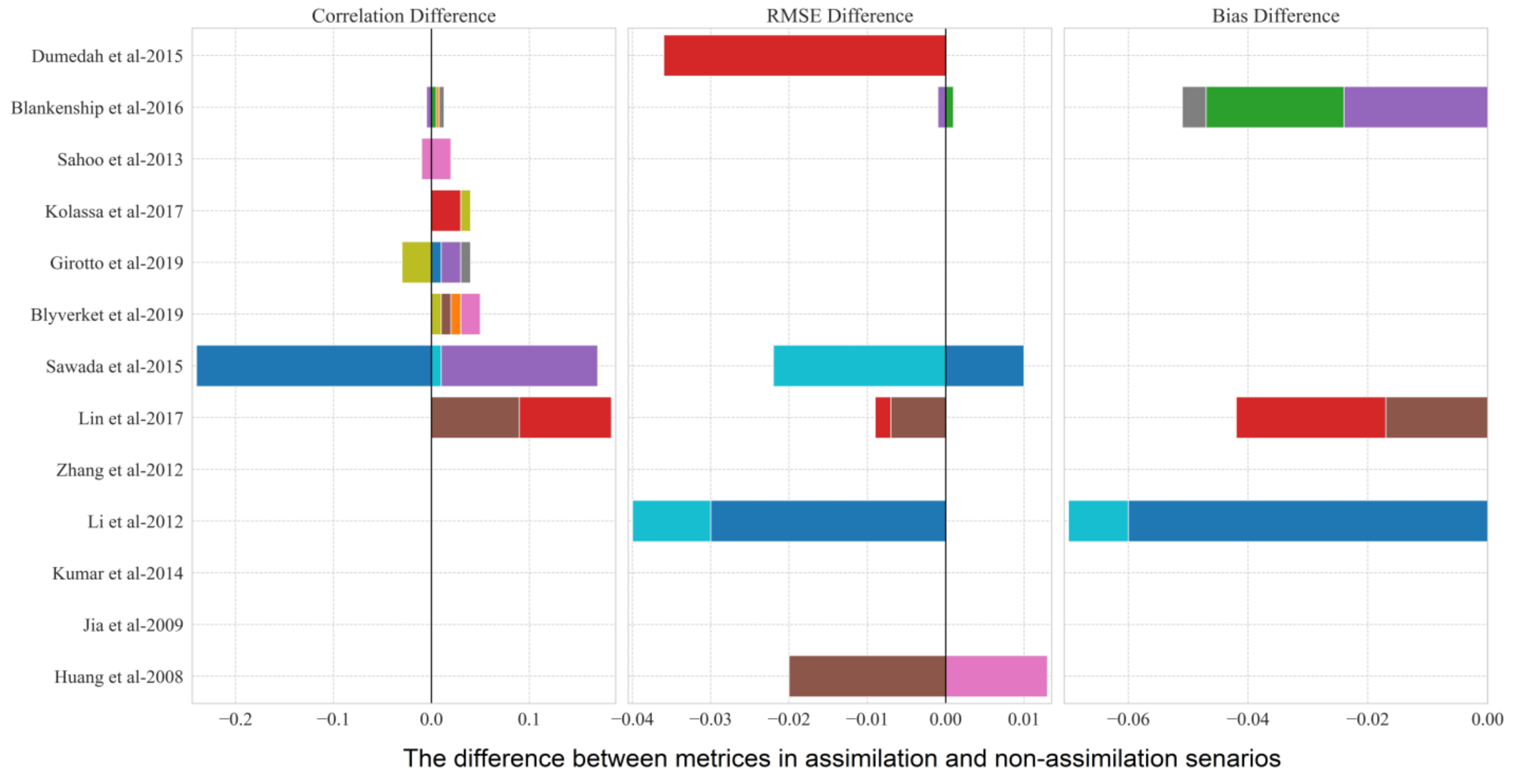
3. The Results of Assimilating BT and SM in LSMs
4. Discussion
- a
- Joint Use of Calibration and Assimilation
- b
- The Role of Precipitation, Vegetation, and Land Cover
- c
- The Joint Assimilation of Satellite Data
- d
- Selection of Assimilation Method
- e
- Selection of Assimilation Period
- f
- Satellite BTs and SMs
- g
- The Spatial Resolution of Satellite Data
Author Contributions
Funding
Institutional Review Board Statement
Informed Consent Statement
Data Availability Statement
Conflicts of Interest
Abbreviations
| AACES | Australian Airborne Cal/Val Experiments for SMOS-AACES |
| AARD | Alberta Agriculture and Rural Development |
| ACCESS-A | Australian Community Climate Earth-System Simulato |
| AGCD | Australian Gridded Climate Data |
| AGDMN | Alberta Ground Drought Monitoring Network |
| ALADIN | Me’te’o-France’s Aire Limite’e Adaptation Dynamique de’veloppement InterNational |
| ALEXI | Atmosphere Land Exchange Inverse |
| AMSR2 | Advanced Microwave Scanning Radiometer 2 |
| AMSR-E | Advanced Microwave Scanning Radiometer–Earth Observing System |
| ARS | Agricultural Research Service |
| ASCAT | Advanced Scatterometer |
| AWDN | Automated Weather Data Network |
| AWRA-L | Australian Water Resources Assessment landscape hydrology model |
| BAWAP | Bureau of Meteorology–Australian Water Availability Project |
| CAM 4.0 | Community Atmosphere Mode |
| caPA | Canadian Precipitation Analysis |
| CCI | Climate Change Initiative |
| CERES | Clouds and the Earth’s Radiant Energy System |
| CLDAS | CMA Land Data Assimilation System |
| CLM | Community Land Model |
| CLSM | Catchment Land Surface Model |
| CMFD | China Meteorological Forcing Dataset |
| COSMOZ | Cosmic ray Soil Moisture Observing System |
| DHSVM | Distributed Hydrology Soil Vegetation Model (DHSVM) |
| EAKF | Ensemble Adjustment Kalman Filter |
| EBKS | Ensemble-Based Kalman smoother |
| ECCC | Environment and Climate Change Canada |
| ECMWF | European Centre for Medium-Range Weather Forecasts (ECMWF) |
| EDA | Evolutionary Data Assimilation |
| EKF | Extende kalman Filter |
| En4DVAR | Ensemble Based Four-Dimensional Variational |
| EnKF | Ensemble Kalman Filter |
| EnOI | Ensemble Optimal Interpolation |
| ERA | ECMWF Re-Analysis |
| ESRF | Ensemble Square Root Filter |
| ETKF | Ensemble Transform Kalman Filter |
| EuropeNet | European Network |
| Evol | Evolutionary |
| FCRN | Fluxnet-Canada Research Network (FCRN) |
| FluxNet (OzFlux) | Australian and New Zealand Flux Research and Monitoring Network |
| FNL | NCEP Final Analysis |
| GDAS | Global Data Assimilation System |
| GEM | Global Environmental Multi-scale Model |
| GEOS-5 | Goddard Earth Observing System Model |
| GLDAS | Global Land Data Assimilation System |
| GLEAM | Global Land Evaporation Amsterdam Model |
| GPCP | Global Precipitation Climatology Project |
| GPF | Genetic Particle Filter |
| GRACE | Gravity Recovery and Climate Experiment |
| GSI | Gridpoint Statistical Interpolation System |
| GSMDB | Global Soil Moisture Data Bank |
| HTESSEL | Hydrology Tiled ECMWF scheme of Surface Exchanges over land |
| ICN | Illinois Climate Network |
| IPF | Improved PF |
| ISBA | Interactions between Soil, Biosphere, and Atmosphere |
| ISCCP | International Satellite Cloud Climatology Project |
| ISMN | International Soil Moisture Network |
| JULES | Joint UK Land Environment Simulator |
| KF | Kalman Filter |
| MAWN | Michigan Automated Weather Network |
| MERRA | Modern-Era Retrospective analysis for Research and Applications |
| MESH | Modélisation Environmentale-Surface et Hydrologie |
| Mesonet | Mesoscale and network |
| MongoliaNet | Mongolia network |
| MSMMN | Murrumbidgee Soil Moisture Monitoring Network |
| MVIRI | Meteosat Visible Infra-Red Imager |
| NASMD | North American Soil Moisture Database |
| NCEP-NCAR | National Centers for Environmental Prediction–National Center for Atmospheric Research |
| NLDAS | North American Land Data Assimilation System |
| Nudg | Nudging |
| OI | Optimal Interpolation |
| OK Mesonet | Oklahoma Mesonet |
| Oznet | Australian monitoring network for soil moisture and micrometeorology |
| PF | Particle Filter |
| PFMCMC | Markov chain Monte Carlo sampling |
| PF-SIR | PF with commonly used sampling importance resampling |
| SAFRAN | Système d’Analyse Fournissant des Renseignements Atmosphériques à la Neige |
| SCAN | Soil Climate Analysis Network |
| SEKF | Simplified Extended Kalman Filter |
| SiB2 | Simple Biosphere Model 2 |
| SMAP | Soil Moisture Active and Passive |
| SMAPCVS | SMAP core validation sites |
| SMMR | Scanning Multichannel Microwave Radiometer |
| SMOPS | Soil Moisture Operational Products System |
| SMOSMANIA | Soil Moisture Observing System–Meteorological Automatic Network Integrated Application |
| SMTMN | Soil Moisture and Temperature Monitoring Network on the central Tibetan Plateau |
| SVS | Soil, Vegetation, and Snow |
| TESSEL | Tiled ECMWF Scheme for Surface Exchanges over Land |
| TMPA | TRMM Multisatellite Precipitation Analysis |
| TRMM | Tropical Rainfall Measuring Mission |
| USCRN | US Climate Reference Network |
| USDA-ARS | United State Agricultural Research Service |
| VIC | Variable Infiltration Capacity |
| W3 | World Wide Water |
| WFDEI | WATCH Forcing Data methodology applied to ERA-Interim reanalysis data |
References
- Loew, A. Impact of surface heterogeneity on surface soil moisture retrievals from passive microwave data at the regional scale: The Upper Danube case. Remote Sens. Environ. 2008, 112, 231–248. [Google Scholar] [CrossRef]
- Seneviratne, S.I.; Corti, T.; Davin, E.L.; Hirschi, M.; Jaeger, E.B.; Lehner, I.; Orlowsky, B.; Teuling, A.J. Investigating soil moisture–climate interactions in a changing climate: A review. Earth-Sci. Rev. 2010, 99, 125–161. [Google Scholar] [CrossRef]
- van der Molen, M.K.; Dolman, A.J.; Ciais, P.; Eglin, T.; Gobron, N.; Law, B.E.; Meir, P.; Peters, W.; Phillips, O.L.; Reichstein, M.; et al. Drought and ecosystem carbon cycling. Agric. For. Meteorol. 2011, 151, 765–773. [Google Scholar] [CrossRef]
- Rasmy, M.; Koike, T.; Boussetta, S.; Lu, H.; Li, X. Development of a satellite land data assimilation system coupled with a mesoscale model in the Tibetan Plateau. IEEE Trans. Geosci. Remote Sens. 2011, 49, 2847–2862. [Google Scholar] [CrossRef]
- De Rosnay, P.; Drusch, M.; Vasiljevic, D.; Balsamo, G.; Albergel, C.; Isaksen, L. A simplified Extended Kalman Filter for the global operational soil moisture analysis at ECMWF. Q. J. R. Meteorol. Soc. 2013, 139, 1199–1213. [Google Scholar] [CrossRef]
- Mahfouf, J.F.; Bergaoui, K.; Draper, C.; Bouyssel, F.; Taillefer, F.; Taseva, L. A comparison of two off-line soil analysis schemes for assimilation of screen level observations. J. Geophys. Res. Atmos. 2009, 114, D08105. [Google Scholar] [CrossRef]
- de Rosnay, P.; Balsamo, G.; Albergel, C.; Muñoz-Sabater, J.; Isaksen, L. Initialisation of land surface variables for numerical weather prediction. Surv. Geophys. 2014, 35, 607–621. [Google Scholar] [CrossRef]
- Petropoulos, G.P.; Ireland, G.; Barrett, B. Surface soil moisture retrievals from remote sensing: Current status, products & future trends. Phys. Chem. Earth Parts A/B/C 2015, 83, 36–56. [Google Scholar]
- Entekhabi, D.; Njoku, E.G.; O’Neill, P.E.; Kellogg, K.H.; Crow, W.T.; Edelstein, W.N.; Entin, J.K.; Goodman, S.D.; Jackson, T.J.; Johnson, J.; et al. The soil moisture active passive (SMAP) mission. Proc. IEEE 2010, 98, 704–716. [Google Scholar] [CrossRef]
- Kerr, Y.H.; Waldteufel, P.; Richaume, P.; Wigneron, J.P.; Ferrazzoli, P.; Mahmoodi, A.; Al Bitar, A.; Cabot, F.; Gruhier, C.; Juglea, S.E.; et al. The SMOS soil moisture retrieval algorithm. IEEE Trans. Geosci. Remote Sens. 2012, 50, 1384–1403. [Google Scholar] [CrossRef]
- Njoku, E.G.; Jackson, T.J.; Lakshmi, V.; Chan, T.K.; Nghiem, S.V. Soil moisture retrieval from AMSR-E. IEEE Trans. Geosci. Remote Sens. 2003, 41, 215–229. [Google Scholar] [CrossRef]
- Imaoka, K.; Kachi, M.; Kasahara, M.; Ito, N.; Nakagawa, K.; Oki, T. Instrument performance and calibration of AMSR-E and AMSR2. Int. Arch. Photogramm. Remote Sens. Spat. Inf. Sci. 2010, 38, 13–18. [Google Scholar]
- Wagner, W.; Hahn, S.; Kidd, R.; Melzer, T.; Bartalis, Z.; Hasenauer, S.; Figa-Saldana, J.; De Rosnay, P.; Jann, A.; Schneider, S.; et al. The ASCAT soil moisture product: A review of its specifications, validation results, and emerging applications. Meteorol. Z. 2013, 22, 5–33. [Google Scholar] [CrossRef] [Green Version]
- Paloscia, S.; Pettinato, S.; Santi, E.; Notarnicola, C.; Pasolli, L.; Reppucci, A. Soil moisture mapping using Sentinel-1 images: Algorithm and preliminary validation. Remote Sens. Environ. 2013, 134, 234–248. [Google Scholar] [CrossRef]
- Njoku, E.G.; Stacey, J.; Barath, F.T. The Seasat scanning multichannel microwave radiometer (SMMR): Instrument description and performance. IEEE J. Ocean. Eng. 1980, 5, 100–115. [Google Scholar] [CrossRef]
- Gao, H.; Wood, E.F.; Jackson, T.; Drusch, M.; Bindlish, R. Using TRMM/TMI to retrieve surface soil moisture over the southern United States from 1998 to 2002. J. Hydrometeorol. 2006, 7, 23–38. [Google Scholar] [CrossRef]
- Wagner, W.; Lemoine, G.; Rott, H. A method for estimating soil moisture from ERS scatterometer and soil data. Remote Sens. Environ. 1999, 70, 191–207. [Google Scholar] [CrossRef]
- Dorigo, W.; Wagner, W.; Albergel, C.; Albrecht, F.; Balsamo, G.; Brocca, L.; Chung, D.; Ertl, M.; Forkel, M.; Gruber, A.; et al. ESA CCI Soil Moisture for improved Earth system understanding: State-of-the art and future directions. Remote Sens. Environ. 2017, 203, 185–215. [Google Scholar] [CrossRef]
- Liu, J.; Zhan, X.; Hain, C.; Yin, J.; Fang, L.; Li, Z.; Zhao, L. NOAA soil moisture operational product system (SMOPS) and its validations. In Proceedings of the 2016 IEEE International Geoscience and Remote Sensing Symposium (IGARSS), Beijing, China, 10–15 July 2016; pp. 3477–3480. [Google Scholar]
- De Lannoy, G.J.M.; de Rosnay, P.; Reichle, R.H. Soil moisture data assimilation. In Handbook of Hydrometeorological Ensemble Forecasting; Springer: Berlin/Heidelberg, Germany, 2016; pp. 1–43. [Google Scholar]
- De Lannoy, G.J.; Reichle, R.H.; Vrugt, J.A. Uncertainty quantification of GEOS-5 L-band radiative transfer model parameters using Bayesian inference and SMOS observations. Remote Sens. Environ. 2014, 148, 146–157. [Google Scholar] [CrossRef] [Green Version]
- Maggioni, V.; Houser, P.R. Soil moisture data assimilation. In Data Assimilation for Atmospheric, Oceanic and Hydrologic Applications; Springer: Berlin/Heidelberg, Germany, 2017; Volume 3, pp. 195–217. [Google Scholar]
- Montzka, C. Soil Moisture Remote Sensing and Data Assimilation. In Remote Sensing of Energy Fluxes and Soil Moisture Content; CRC Press: Boca Raton, FL, USA, 2013; pp. 415–434. [Google Scholar]
- Lu, H.; Koike, T.; Yang, K.; Hu, Z.; Xu, X.; Rasmy, M.; Kuria, D.; Tamagawa, K. Improving land surface soil moisture and energy flux simulations over the Tibetan plateau by the assimilation of the microwave remote sensing data and the GCM output into a land surface model. Int. J. Appl. Earth Obs. Geoinf. 2012, 17, 43–54. [Google Scholar] [CrossRef]
- Zhao, L.; Yang, K.; Qin, J.; Chen, Y.; Tang, W.; Lu, H.; Yang, Z.-L. The scale-dependence of SMOS soil moisture accuracy and its improvement through land data assimilation in the central Tibetan Plateau. Remote Sens. Environ. 2014, 152, 345–355. [Google Scholar] [CrossRef]
- Tian, X.; Xie, Z.; Dai, A.; Shi, C.; Jia, B.; Chen, F.; Yang, K. A dual-pass variational data assimilation framework for estimating soil moisture profiles from AMSR-E microwave brightness temperature. J. Geophys. Res. Atmos. 2009, 114, D16102. [Google Scholar] [CrossRef] [Green Version]
- Koster, R.D.; Liu, Q.; Mahanama, S.P.; Reichle, R.H. Improved hydrological simulation using SMAP data: Relative impacts of model calibration and data assimilation. J. Hydrometeorol. 2018, 19, 727–741. [Google Scholar] [CrossRef]
- De Lannoy, G.J.; Reichle, R.H. Global assimilation of multiangle and multipolarization SMOS brightness temperature observations into the GEOS-5 catchment land surface model for soil moisture estimation. J. Hydrometeorol. 2016, 17, 669–691. [Google Scholar] [CrossRef] [Green Version]
- Sawada, Y.; Koike, T.; Walker, J.P. A land data assimilation system for simultaneous simulation of soil moisture and vegetation dynamics. J. Geophys. Res. Atmos. 2015, 120, 5910–5930. [Google Scholar] [CrossRef]
- Mitchell, K. The Community Noah Land-Surface Model (LSM); NOAA/NCEP/Environmental Modeling Center, 2005. Available online: https://ftp.emc.ncep.noaa.gov/mmb/gcp/ldas/noahlsm/ver_2.7.1/ (accessed on 2 February 2022).
- Niu, G.Y.; Yang, Z.L.; Mitchell, K.E.; Chen, F.; Ek, M.B.; Barlage, M.; Kumar, A.; Manning, K.; Niyogi, D.; Rosero, E. The community Noah land surface model with multiparameterization options (Noah-MP): 1. Model description and evaluation with local-scale measurements. J. Geophys. Res. Atmos. 2011, 116, D12109. [Google Scholar] [CrossRef] [Green Version]
- Van Dijk, A.; Warren, G. The Australian Water Resources Assessment System; Technical Report 3, Version 0.5; Australian Government Bureau of Meteorology: Melbourne, Australia, 2010.
- Koster, R.D.; Suarez, M.J.; Ducharne, A.; Stieglitz, M.; Kumar, P. A catchment-based approach to modeling land surface processes in a general circulation model: 1. Model structure. J. Geophys. Res. Atmos. 2000, 105, 24809–24822. [Google Scholar] [CrossRef]
- Lawrence, D.M.; Fisher, R.A.; Koven, C.D.; Oleson, K.W.; Swenson, S.C.; Bonan, G.; Collier, N.; Ghimire, B.; van Kampenhout, L.; Kennedy, D.; et al. The Community Land Model version 5: Description of new features, benchmarking, and impact of forcing uncertainty. J. Adv. Model. Earth Syst. 2019, 11, 4245–4287. [Google Scholar] [CrossRef] [Green Version]
- Best, M.; Pryor, M.; Clark, D.; Rooney, G.; Essery, R.; Ménard, C.; Edwards, J.; Hendry, M.; Porson, A.; Gedney, N. The Joint UK Land Environment Simulator (JULES), model description—Part 1: Energy and water fluxes. Geosci. Model Dev. 2011, 4, 677–699. [Google Scholar] [CrossRef] [Green Version]
- Decharme, B.; Boone, A.; Delire, C.; Noilhan, J. Local evaluation of the Interaction between Soil Biosphere Atmosphere soil multilayer diffusion scheme using four pedotransfer functions. J. Geophys. Res. Atmos. 2011, 116, D20126. [Google Scholar] [CrossRef]
- Sellers, P.; Randall, D.; Collatz, G.; Berry, J.; Field, C.; Dazlich, D.; Zhang, C.; Collelo, G.; Bounoua, L. A revised land surface parameterization (SiB2) for atmospheric GCMs. Part I: Model formulation. J. Clim. 1996, 9, 676–705. [Google Scholar] [CrossRef]
- Liang, X.; Lettenmaier, D.P.; Wood, E.F.; Burges, S.J. A simple hydrologically based model of land surface water and energy fluxes for general circulation models. J. Geophys. Res. Atmos. 1994, 99, 14415–14428. [Google Scholar] [CrossRef]
- Alavi, N.; Bélair, S.; Fortin, V.; Zhang, S.; Husain, S.Z.; Carrera, M.L.; Abrahamowicz, M. Warm season evaluation of soil moisture prediction in the Soil, Vegetation, and Snow (SVS) scheme. J. Hydrometeorol. 2016, 17, 2315–2332. [Google Scholar] [CrossRef]
- Van Dijk, A.I.; Peña-Arancibia, J.L.; Wood, E.F.; Sheffield, J.; Beck, H.E. Global analysis of seasonal streamflow predictability using an ensemble prediction system and observations from 6192 small catchments worldwide. Water Resour. Res. 2013, 49, 2729–2746. [Google Scholar] [CrossRef]
- Miralles, D.; De Jeu, R.; Gash, J.; Holmes, T.; Dolman, A. Magnitude and variability of land evaporation and its components at the global scale. Hydrol. Earth Syst. Sci. 2011, 15, 967–981. [Google Scholar] [CrossRef] [Green Version]
- Wigmosta, M.S.; Nijssen, B.; Storck, P.; Lettenmaier, D. The distributed hydrology soil vegetation model. In Mathematical Models of Small Watershed Hydrology and Applications; Water Resources Publications: Littleton, CO, USA, 2002; pp. 7–42. [Google Scholar]
- Simunek, J.; Van Genuchten, M.T.; Sejna, M. The HYDRUS-1D software package for simulating the one-dimensional movement of water, heat, and multiple solutes in variably-saturated media. Univ. Calif. Riverside Res. Rep. 2005, 3, 1–240. [Google Scholar]
- Pietroniro, A.; Fortin, V.; Kouwen, N.; Neal, C.; Turcotte, R.; Davison, B.; Verseghy, D.; Soulis, E.; Caldwell, R.; Evora, N.; et al. Development of the MESH modelling system for hydrological ensemble forecasting of the Laurentian Great Lakes at the regional scale. Hydrol. Earth Syst. Sci. 2007, 11, 1279–1294. [Google Scholar] [CrossRef] [Green Version]
- Shuttleworth, W.J.; Wallace, J. Evaporation from sparse crops-an energy combination theory. Q. J. R. Meteorol. Soc. 1985, 111, 839–855. [Google Scholar] [CrossRef]
- Balsamo, G.; Beljaars, A.; Scipal, K.; Viterbo, P.; van den Hurk, B.; Hirschi, M.; Betts, A.K. A revised hydrology for the ECMWF model: Verification from field site to terrestrial water storage and impact in the Integrated Forecast System. J. Hydrometeorol. 2009, 10, 623–643. [Google Scholar] [CrossRef]
- Essery, R.; Best, M.; Cox, P. MOSES 2.2 Technical Documentation (Hadley Centre Technical Note 30); Hadley Centre, Met Office: Exeter, UK, 2001. [Google Scholar]
- Chen, F.; Dudhia, J. Coupling an advanced land surface–hydrology model with the Penn State–NCAR MM5 modeling system. Part I: Model implementation and sensitivity. Mon. Weather Rev. 2001, 129, 569–585. [Google Scholar] [CrossRef] [Green Version]
- Tian, X.; Xie, Z.; Dai, A.; Jia, B.; Shi, C. A microwave land data assimilation system: Scheme and preliminary evaluation over China. J. Geophys. Res. Atmos. 2010, 115, D21113. [Google Scholar] [CrossRef]
- Ramadevi, G.; Parvathi, S.; Kumaresan, A.; Vijayakumar, K. Modern-era retrospective analysis for research and applications. Adv. Nat. Appl. Sci. 2017, 11, 109–113. [Google Scholar]
- Blyverket, J.; Hamer, P.D.; Bertino, L.; Albergel, C.; Fairbairn, D.; Lahoz, W.A. An Evaluation of the EnKF vs. EnOI and the Assimilation of SMAP, SMOS and ESA CCI Soil Moisture Data over the Contiguous US. Remote Sens. 2019, 11, 478. [Google Scholar] [CrossRef] [Green Version]
- Liu, Q.; Reichle, R.H.; Bindlish, R.; Cosh, M.H.; Crow, W.T.; de Jeu, R.; De Lannoy, G.J.; Huffman, G.J.; Jackson, T.J. The contributions of precipitation and soil moisture observations to the skill of soil moisture estimates in a land data assimilation system. J. Hydrometeorol. 2011, 12, 750–765. [Google Scholar] [CrossRef]
- Jia, B.; Tian, X.; Xie, Z.; Liu, J.; Shi, C. Assimilation of microwave brightness temperature in a land data assimilation system with multi-observation operators. J. Geophys. Res. Atmos. 2013, 118, 3972–3985. [Google Scholar] [CrossRef]
- Wigneron, J.-P.; Jackson, T.; O’neill, P.; De Lannoy, G.; De Rosnay, P.; Walker, J.; Ferrazzoli, P.; Mironov, V.; Bircher, S.; Grant, J.; et al. Modelling the passive microwave signature from land surfaces: A review of recent results and application to the L-band SMOS & SMAP soil moisture retrieval algorithms. Remote Sens. Environ. 2017, 192, 238–262. [Google Scholar]
- Karthikeyan, L.; Pan, M.; Wanders, N.; Kumar, D.N.; Wood, E.F. Four decades of microwave satellite soil moisture observations: Part 1. A review of retrieval algorithms. Adv. Water Resour. 2017, 109, 106–120. [Google Scholar] [CrossRef]
- Lv, S.; Zeng, Y.; Wen, J.; Zhao, H.; Su, Z. Estimation of penetration depth from soil effective temperature in microwave radiometry. Remote Sens. 2018, 10, 519. [Google Scholar] [CrossRef] [Green Version]
- Usowicz, B.; Lukowski, M.; Lipiec, J. The SMOS-Derived Soil Water EXtent and equivalent layer thickness facilitate determination of soil water resources. Sci. Rep. 2020, 10, 1–12. [Google Scholar] [CrossRef]
- Martens, B.; Miralles, D.; Lievens, H.; Fernández-Prieto, D.; Verhoest, N.E. Improving terrestrial evaporation estimates over continental Australia through assimilation of SMOS soil moisture. Int. J. Appl. Earth Obs. Geoinf. 2016, 48, 146–162. [Google Scholar] [CrossRef]
- Yee, M.S.; Walker, J.P.; Rüdiger, C.; Parinussa, R.M.; Koike, T.; Kerr, Y.H. A comparison of SMOS and AMSR2 soil moisture using representative sites of the OzNet monitoring network. Remote Sens. Environ. 2017, 195, 297–312. [Google Scholar] [CrossRef]
- Jing, W.; Song, J.; Zhao, X. Evaluation of Multiple Satellite-Based Soil Moisture Products over Continental US Based on In Situ Measurements. Water Resour. Manag. 2018, 32, 3233–3246. [Google Scholar] [CrossRef]
- Albergel, C.; Rüdiger, C.; Carrer, D.; Calvet, J.-C.; Fritz, N.; Naeimi, V.; Bartalis, Z.; Hasenauer, S. An evaluation of ASCAT surface soil moisture products with in-situ observations in Southwestern France. Hydrol. Earth Syst. Sci. 2009, 13, 115–124. [Google Scholar] [CrossRef] [Green Version]
- Lei, F.; Crow, W.T.; Shen, H.; Parinussa, R.M.; Holmes, T.R. The impact of local acquisition time on the accuracy of microwave surface soil moisture retrievals over the contiguous United States. Remote Sens. 2015, 7, 13448–13465. [Google Scholar] [CrossRef] [Green Version]
- O’Neill, P.; Bindlish, R.; Steven, C.; Julian, C.; Eni, N.; Tom, J. Algorithm Theoretical Basis Document Level 2 & 3 Soil Moisture (Passive) Data Products; Jet Propulsion Laboratory: Pasadena, CA, USA, 2020. [Google Scholar]
- Yueh, S.H. Estimates of Faraday rotation with passive microwave polarimetry for microwave remote sensing of Earth surfaces. IEEE Trans. Geosci. Remote Sens. 2000, 38, 2434–2438. [Google Scholar] [CrossRef]
- Beck, H.E.; Pan, M.; Miralles, D.G.; Reichle, R.H.; Dorigo, W.A.; Hahn, S.; Sheffield, J.; Karthikeyan, L.; Balsamo, G.; Parinussa, R.M.; et al. Evaluation of 18 satellite-and model-based soil moisture products using in situ measurements from 826 sensors. Hydrol. Earth Syst. Sci. 2021, 25, 17–40. [Google Scholar] [CrossRef]
- Bosch, P.S.; Goodrich, D.; Prueger, J.; Palecki, M.; Small, E.; Zreda, M.; Calvet, J.; Crow, W. SMAP L2 Radiometer Half-Orbit 36 km EASE-Grid Soil Moisture, Version 6. Available online: https://nsidc.org/sites/nsidc.org/files/SPL2SMP-V006-UserGuide_0.pdf (accessed on 2 February 2022).
- Zwieback, S.; Westermann, S.; Langer, M.; Boike, J.; Marsh, P.; Berg, A. Improving permafrost modeling by assimilating remotely sensed soil moisture. Water Resour. Res. 2019, 55, 1814–1832. [Google Scholar] [CrossRef]
- Yin, J.; Zhan, X.; Liu, J.; Schull, M. An Intercomparison of Noah Model Skills With Benefits of Assimilating SMOPS Blended and Individual Soil Moisture Retrievals. Water Resour. Res. 2019, 55, 2572–2592. [Google Scholar] [CrossRef]
- Sabaghy, S.; Walker, J.P.; Renzullo, L.J.; Akbar, R.; Chan, S.; Chaubell, J.; Das, N.; Dunbar, R.S.; Entekhabi, D.; Gevaert, A.; et al. Comprehensive analysis of alternative downscaled soil moisture products. Remote Sens. Environ. 2020, 239, 111586. [Google Scholar] [CrossRef]
- Lievens, H.; De Lannoy, G.; Al Bitar, A.; Drusch, M.; Dumedah, G.; Franssen, H.-J.H.; Kerr, Y.; Tomer, S.K.; Martens, B.; Merlin, O.; et al. Assimilation of SMOS soil moisture and brightness temperature products into a land surface model. Remote Sens. Environ. 2016, 180, 292–304. [Google Scholar] [CrossRef] [Green Version]
- Fujii, H. Development of a Microwave Radiative Transfer Model for Vegetated Land Surface Based on Comprehensive In Situ Observations. Ph.D. Thesis, The University of Tokyo, Tokyo, Japan, 2005. [Google Scholar]
- Shellito, P.J.; Small, E.E.; Livneh, B. Controls on surface soil drying rates observed by SMAP and simulated by the Noah land surface model. Hydrol. Earth Syst. Sci. 2018, 22, 1649–1663. [Google Scholar] [CrossRef] [Green Version]
- Ma, H.; Zeng, J.; Chen, N.; Zhang, X.; Cosh, M.H.; Wang, W. Satellite surface soil moisture from SMAP, SMOS, AMSR2 and ESA CCI: A comprehensive assessment using global ground-based observations. Remote Sens. Environ. 2019, 231, 111215. [Google Scholar] [CrossRef]
- Al-Yaari, A.; Wigneron, J.-P.; Dorigo, W.; Colliander, A.; Pellarin, T.; Hahn, S.; Mialon, A.; Richaume, P.; Fernandez-Moran, R.; Fan, L.; et al. Assessment and inter-comparison of recently developed/reprocessed microwave satellite soil moisture products using ISMN ground-based measurements. Remote Sens. Environ. 2019, 224, 289–303. [Google Scholar] [CrossRef]
- Li, X.; Wigneron, J.-P.; Frappart, F.; Fan, L.; Wang, M.; Liu, X.; Al-Yaari, A.; Moisy, C. Development and validation of the SMOS-IC version 2 (V2) soil moisture product. In Proceedings of the IGARSS 2020–2020 IEEE International Geoscience and Remote Sensing Symposium, Waikoloa, HI, USA, 26 September–2 October 2020; pp. 4434–4437. [Google Scholar]
- Gruber, A.; De Lannoy, G.; Albergel, C.; Al-Yaari, A.; Brocca, L.; Calvet, J.-C.; Colliander, A.; Cosh, M.; Crow, W.; Dorigo, W. Validation practices for satellite soil moisture retrievals: What are (the) errors? Remote Sens. Environ. 2020, 244, 111806. [Google Scholar] [CrossRef]
- Zhao, L.; Yang, Z.-L.; Hoar, T.J. Global soil moisture estimation by assimilating AMSR-E brightness temperatures in a coupled CLM4–RTM–DART system. J. Hydrometeorol. 2016, 17, 2431–2454. [Google Scholar] [CrossRef]
- Lu, H.; Yang, K.; Koike, T.; Zhao, L.; Qin, J. An improvement of the radiative transfer model component of a land data assimilation system and its validation on different land characteristics. Remote Sens. 2015, 7, 6358–6379. [Google Scholar] [CrossRef] [Green Version]
- Yang, K.; Watanabe, T.; Koike, T.; Li, X.; Fujii, H.; Tamagawa, K.; Ma, Y.; Ishikawa, H. Auto-calibration system developed to assimilate AMSR-E data into a land surface model for estimating soil moisture and the surface energy budget. J. Meteorol. Soc. Jpn. Ser. II 2007, 85, 229–242. [Google Scholar] [CrossRef] [Green Version]
- Yang, K.; Koike, T.; Kaihotsu, I.; Qin, J. Validation of a dual-pass microwave land data assimilation system for estimating surface soil moisture in semiarid regions. J. Hydrometeorol. 2009, 10, 780–793. [Google Scholar] [CrossRef] [Green Version]
- Duan, Q.; Gupta, V.K.; Sorooshian, S. Shuffled complex evolution approach for effective and efficient global minimization. J. Optim. Theory Appl. 1993, 76, 501–521. [Google Scholar] [CrossRef]
- Tian, X.; Xie, Z.; Dai, A. An ensemble conditional nonlinear optimal perturbation approach: Formulation and applications to parameter calibration. Water Resour. Res. 2010, 46, W09540. [Google Scholar] [CrossRef]
- De Lannoy, G.J.; Reichle, R.H.; Pauwels, V.R. Global calibration of the GEOS-5 L-band microwave radiative transfer model over nonfrozen land using SMOS observations. J. Hydrometeorol. 2013, 14, 765–785. [Google Scholar] [CrossRef] [Green Version]
- Qin, J.; Liang, S.; Yang, K.; Kaihotsu, I.; Liu, R.; Koike, T. Simultaneous estimation of both soil moisture and model parameters using particle filtering method through the assimilation of microwave signal. J. Geophys. Res. Atmos. 2009, 114, D15103. [Google Scholar] [CrossRef]
- Tao, L.; Wang, G.; Chen, W.; Chen, X.; Li, J.; Cai, Q. Soil moisture retrieval from SAR and optical data using a combined model. IEEE J. Sel. Top. Appl. Earth Obs. Remote Sens. 2019, 12, 637–647. [Google Scholar] [CrossRef]
- Parrens, M.; Wigneron, J.-P.; Richaume, P.; Mialon, A.; Al Bitar, A.; Fernandez-Moran, R.; Al-Yaari, A.; Kerr, Y.H. Global-scale surface roughness effects at L-band as estimated from SMOS observations. Remote Sens. Environ. 2016, 181, 122–136. [Google Scholar] [CrossRef]
- Weng, F.; Yan, B.; Grody, N.C. A microwave land emissivity model. J. Geophys. Res. Atmos. 2001, 106, 20115–20123. [Google Scholar] [CrossRef]
- Drusch, M.; Holmes, T.; de Rosnay, P.; Balsamo, G. Comparing ERA-40-based L-band brightness temperatures with Skylab observations: A calibration/validation study using the Community Microwave Emission Model. J. Hydrometeorol. 2009, 10, 213–226. [Google Scholar] [CrossRef]
- Mo, T.; Choudhury, B.; Schmugge, T.; Wang, J.; Jackson, T. A model for microwave emission from vegetation-covered fields. J. Geophys. Res. Ocean. 1982, 87, 11229–11237. [Google Scholar] [CrossRef]
- Zhang, S.; Shi, J.; Dou, Y. A soil moisture assimilation scheme based on the microwave land emissivity model and the community land model. Int. J. Remote Sens. 2012, 33, 2770–2797. [Google Scholar] [CrossRef]
- Wigneron, J.-P.; Pardé, M.; Waldteufel, P.; Chanzy, A.; Kerr, Y.; Schmidl, S.; Skou, N. Characterizing the dependence of vegetation model parameters on crop structure, incidence angle, and polarization at L-band. IEEE Trans. Geosci. Remote Sens. 2004, 42, 416–425. [Google Scholar] [CrossRef]
- Wigneron, J.-P.; Laguerre, L.; Kerr, Y.H. A simple parameterization of the L-band microwave emission from rough agricultural soils. IEEE Trans. Geosci. Remote Sens. 2001, 39, 1697–1707. [Google Scholar] [CrossRef]
- Wigneron, J.-P.; Kerr, Y.; Waldteufel, P.; Saleh, K.; Escorihuela, M.-J.; Richaume, P.; Ferrazzoli, P.; De Rosnay, P.; Gurney, R.; Calvet, J.-C.; et al. L-band Microwave Emission of the Biosphere (L-MEB) Model: Description and calibration against experimental data sets over crop fields. Remote Sens. Environ. 2007, 107, 639–655. [Google Scholar] [CrossRef]
- Jia, B.; Xie, Z.; Tian, X.; Shi, C. A soil moisture assimilation scheme based on the ensemble Kalman filter using microwave brightness temperature. Sci. China Ser. D Earth Sci. 2009, 52, 1835. [Google Scholar] [CrossRef]
- Sawada, Y.; Koike, T. Simultaneous estimation of both hydrological and ecological parameters in an ecohydrological model by assimilating microwave signal. J. Geophys. Res. Atmos. 2014, 119, 8839–8857. [Google Scholar] [CrossRef]
- Montzka, C.; Grant, J.P.; Moradkhani, H.; Franssen, H.-J.H.; Weihermüller, L.; Drusch, M.; Vereecken, H. Estimation of radiative transfer parameters from L-band passive microwave brightness temperatures using advanced data assimilation. Vadose Zone J. 2013, 12, vzj2012.0040. [Google Scholar] [CrossRef] [Green Version]
- Yang, K.; Zhu, L.; Chen, Y.; Zhao, L.; Qin, J.; Lu, H.; Tang, W.; Han, M.; Ding, B.; Fang, N. Land surface model calibration through microwave data assimilation for improving soil moisture simulations. J. Hydrol. 2016, 533, 266–276. [Google Scholar] [CrossRef]
- Kumar, S.V.; Reichle, R.H.; Harrison, K.W.; Peters-Lidard, C.D.; Yatheendradas, S.; Santanello, J.A. A comparison of methods for a priori bias correction in soil moisture data assimilation. Water Resour. Res. 2012, 48, W03515. [Google Scholar] [CrossRef]
- Afshar, M.; Yilmaz, M. The added utility of nonlinear methods compared to linear methods in rescaling soil moisture products. Remote Sens. Environ. 2017, 196, 224–237. [Google Scholar] [CrossRef] [Green Version]
- Brocca, L.; Melone, F.; Moramarco, T.; Wagner, W.; Albergel, C. Scaling and filtering approaches for the use of satellite soil moisture observations. In Remote Sensing of Energy Fluxes and Soil Moisture Content; Routledge: Abingron-on-Thames, UK, 2013; pp. 411–426. [Google Scholar]
- Yilmaz, M.T.; Crow, W.T. The optimality of potential rescaling approaches in land data assimilation. J. Hydrometeorol. 2013, 14, 650–660. [Google Scholar] [CrossRef]
- Fertig, E.; Baek, S.-J.; Hunt, B.; Ott, E.; Szunyogh, I.; Aravéquia, J.; Kalnay, E.; Li, H.; Liu, J. Observation bias correction with an ensemble Kalman filter. Tellus A Dyn. Meteorol. Oceanogr. 2009, 61, 210–226. [Google Scholar] [CrossRef] [Green Version]
- De Lannoy, G.J.; Houser, P.R.; Pauwels, V.R.; Verhoest, N.E. State and bias estimation for soil moisture profiles by an ensemble Kalman filter: Effect of assimilation depth and frequency. Water Resour. Res. 2007, 43, W06401. [Google Scholar] [CrossRef] [Green Version]
- De Lannoy, G.J.; Reichle, R.H.; Houser, P.R.; Pauwels, V.R.; Verhoest, N.E. Correcting for forecast bias in soil moisture assimilation with the ensemble Kalman filter. Water Resour. Res. 2007, 43, W09410. [Google Scholar] [CrossRef] [Green Version]
- Bosilovich, M.G.; Radakovich, J.D.; da Silva, A.; Todling, R.; Verter, F. Skin temperature analysis and bias correction in a coupled land-atmosphere data assimilation system. J. Meteorol. Soc. Jpn. Ser. II 2007, 85, 205–228. [Google Scholar] [CrossRef] [Green Version]
- Reichle, R.H.; Kumar, S.V.; Mahanama, S.P.; Koster, R.D.; Liu, Q. Assimilation of satellite-derived skin temperature observations into land surface models. J. Hydrometeorol. 2010, 11, 1103–1122. [Google Scholar] [CrossRef] [Green Version]
- Ridler, M.E.; Madsen, H.; Stisen, S.; Bircher, S.; Fensholt, R. Assimilation of SMOS-derived soil moisture in a fully integrated hydrological and soil-vegetation-atmosphere transfer model in Western Denmark. Water Resour. Res. 2014, 50, 8962–8981. [Google Scholar] [CrossRef]
- Lievens, H.; Tomer, S.K.; Al Bitar, A.; De Lannoy, G.J.; Drusch, M.; Dumedah, G.; Franssen, H.-J.H.; Kerr, Y.H.; Martens, B.; Pan, M.; et al. SMOS soil moisture assimilation for improved hydrologic simulation in the Murray Darling Basin, Australia. Remote Sens. Environ. 2015, 168, 146–162. [Google Scholar] [CrossRef]
- Reichle, R.H.; Koster, R.D. Bias reduction in short records of satellite soil moisture. Geophys. Res. Lett. 2004, 31, L19501. [Google Scholar] [CrossRef] [Green Version]
- Mahfouf, J.F. Assimilation of satellite-derived soil moisture from ASCAT in a limited-area NWP model. Q. J. R. Meteorol. Soc. A J. Atmos. Sci. Appl. Meteorol. Phys. Oceanogr. 2010, 136, 784–798. [Google Scholar] [CrossRef]
- Kolassa, J.; Reichle, R.; Liu, Q.; Cosh, M.; Bosch, D.; Caldwell, T.; Colliander, A.; Holifield Collins, C.; Jackson, T.; Livingston, S.; et al. Data assimilation to extract soil moisture information from SMAP observations. Remote Sens. 2017, 9, 1179. [Google Scholar] [CrossRef] [Green Version]
- Schneider, S.; Wang, Y.; Wagner, W.; Mahfouf, J.-F. Impact of ASCAT soil moisture assimilation on regional precipitation forecasts: A case study for Austria. Mon. Weather Rev. 2014, 142, 1525–1541. [Google Scholar] [CrossRef]
- Blankenship, C.B.; Case, J.L.; Crosson, W.L.; Zavodsky, B.T. Correction of forcing-related spatial artifacts in a land surface model by satellite soil moisture data assimilation. IEEE Geosci. Remote Sens. Lett. 2018, 15, 498–502. [Google Scholar] [CrossRef]
- Blankenship, C.B.; Case, J.L.; Zavodsky, B.T.; Crosson, W.L. Assimilation of SMOS retrievals in the Land Information System. IEEE Trans. Geosci. Remote Sens. 2016, 54, 6320–6332. [Google Scholar] [CrossRef] [Green Version]
- Kumar, S.; Peters-Lidard, C.; Santanello, J.; Reichle, R.; Draper, C.; Koster, R.; Nearing, G.; Jasinski, M. Evaluating the utility of satellite soil moisture retrievals over irrigated areas and the ability of land data assimilation methods to correct for unmodeled processes. Hydrol. Earth Syst. Sci. 2015, 19, 4463–4478. [Google Scholar] [CrossRef] [Green Version]
- Santanello, J.A., Jr.; Kumar, S.V.; Peters-Lidard, C.D.; Lawston, P.M. Impact of soil moisture assimilation on land surface model spinup and coupled land–atmosphere prediction. J. Hydrometeorol. 2016, 17, 517–540. [Google Scholar] [CrossRef]
- Barbu, A.; Calvet, J.-C.; Mahfouf, J.-F.; Lafont, S. Integrating ASCAT surface soil moisture and GEOV1 leaf area index into the SURFEX modelling platform: A land data assimilation application over France. Hydrol. Earth Syst. Sci. 2014, 18, 173–192. [Google Scholar] [CrossRef] [Green Version]
- Draper, C.; Mahfouf, J.F.; Walker, J.P. An EKF assimilation of AMSR-E soil moisture into the ISBA land surface scheme. J. Geophys. Res. Atmos. 2009, 114, D20104. [Google Scholar] [CrossRef] [Green Version]
- Carrera, M.L.; Bilodeau, B.; Bélair, S.; Abrahamowicz, M.; Russell, A.; Wang, X. Assimilation of passive L-band microwave brightness temperatures in the Canadian Land Data Assimilation System: Impacts on short-range warm season Numerical Weather Prediction. J. Hydrometeorol. 2019, 20, 1053–1079. [Google Scholar] [CrossRef]
- Yin, J.; Zhan, X. Impact of bias-correction methods on effectiveness of assimilating SMAP soil moisture data into NCEP global forecast system using the ensemble Kalman filter. IEEE Geosci. Remote Sens. Lett. 2018, 15, 659–663. [Google Scholar] [CrossRef]
- Lin, L.F.; Ebtehaj, A.M.; Wang, J.; Bras, R.L. Soil moisture background error covariance and data assimilation in a coupled land-atmosphere model. Water Resour. Res. 2017, 53, 1309–1335. [Google Scholar] [CrossRef]
- Kalman, R.E. A new approach to linear filtering and prediction problems. Trans. ASME J. Basic Eng. D 1960, 82, 35–45. [Google Scholar] [CrossRef] [Green Version]
- Evensen, G. Using the extended Kalman filter with a multilayer quasi-geostrophic ocean model. J. Geophys. Res. Ocean. 1992, 97, 17905–17924. [Google Scholar] [CrossRef] [Green Version]
- Anderson, J.L. An ensemble adjustment Kalman filter for data assimilation. Mon. Weather Rev. 2001, 129, 2884–2903. [Google Scholar] [CrossRef] [Green Version]
- Evensen, G.; Van Leeuwen, P.J. An ensemble Kalman smoother for nonlinear dynamics. Mon. Weather Rev. 2000, 128, 1852–1867. [Google Scholar] [CrossRef] [Green Version]
- Liu, C.; Xiao, Q.; Wang, B. An ensemble-based four-dimensional variational data assimilation scheme. Part I: Technical formulation and preliminary test. Mon. Weather Rev. 2008, 136, 3363–3373. [Google Scholar] [CrossRef] [Green Version]
- Evensen, G. The ensemble Kalman filter: Theoretical formulation and practical implementation. Ocean Dyn. 2003, 53, 343–367. [Google Scholar] [CrossRef]
- Oke, P.R.; Allen, J.S.; Miller, R.N.; Egbert, G.D.; Kosro, P.M. Assimilation of surface velocity data into a primitive equation coastal ocean model. J. Geophys. Res. Ocean. 2002, 107, 5-1–5-25. [Google Scholar] [CrossRef]
- Sakov, P.; Oke, P.R. Implications of the form of the ensemble transformation in the ensemble square root filters. Mon. Weather Rev. 2008, 136, 1042–1053. [Google Scholar] [CrossRef] [Green Version]
- Bishop, C.H.; Etherton, B.J.; Majumdar, S.J. Adaptive sampling with the ensemble transform Kalman filter. Part I: Theoretical aspects. Mon. Weather Rev. 2001, 129, 420–436. [Google Scholar] [CrossRef]
- Dumedah, G. Formulation of the evolutionary-based data assimilation, and its implementation in hydrological forecasting. Water Resour. Manag. 2012, 26, 3853–3870. [Google Scholar] [CrossRef]
- Arulampalam, M.S.; Maskell, S.; Gordon, N.; Clapp, T. A tutorial on particle filters for online nonlinear/non-Gaussian Bayesian tracking. IEEE Trans. Signal Process. 2002, 50, 174–188. [Google Scholar] [CrossRef] [Green Version]
- Hoke, J.E.; Anthes, R.A. The initialization of numerical models by a dynamic-initialization technique. Mon. Weather Rev. 1976, 104, 1551–1556. [Google Scholar] [CrossRef] [Green Version]
- Houser, P.R.; Shuttleworth, W.J.; Famiglietti, J.S.; Gupta, H.V.; Syed, K.H.; Goodrich, D.C. Integration of soil moisture remote sensing and hydrologic modeling using data assimilation. Water Resour. Res. 1998, 34, 3405–3420. [Google Scholar] [CrossRef] [Green Version]
- Giard, D.; Bazile, E. Implementation of a new assimilation scheme for soil and surface variables in a global NWP model. Mon. Weather Rev. 2000, 128, 997–1015. [Google Scholar] [CrossRef]
- Sasaki, Y. An objective analysis based on the variational method. J. Meteorol. Soc. Jpn. Ser. II 1958, 36, 77–88. [Google Scholar] [CrossRef] [Green Version]
- Dumedah, G.; Walker, J.P. Evaluation of model parameter convergence when using data assimilation for soil moisture estimation. J. Hydrometeorol. 2014, 15, 359–375. [Google Scholar] [CrossRef] [Green Version]
- Reichle, R.H.; Walker, J.P.; Koster, R.D.; Houser, P.R. Extended versus ensemble Kalman filtering for land data assimilation. J. Hydrometeorol. 2002, 3, 728–740. [Google Scholar] [CrossRef]
- Sabater, J.M.; Jarlan, L.; Calvet, J.-C.; Bouyssel, F.; De Rosnay, P. From near-surface to root-zone soil moisture using different assimilation techniques. J. Hydrometeorol. 2007, 8, 194–206. [Google Scholar] [CrossRef]
- Bi, H.; Ma, J.; Wang, F. An improved particle filter algorithm based on ensemble Kalman filter and Markov chain Monte Carlo method. IEEE J. Sel. Top. Appl. Earth Obs. Remote Sens. 2014, 8, 447–459. [Google Scholar] [CrossRef]
- Yan, H.; DeChant, C.M.; Moradkhani, H. Improving soil moisture profile prediction with the particle filter-Markov chain Monte Carlo method. IEEE Trans. Geosci. Remote Sens. 2015, 53, 6134–6147. [Google Scholar] [CrossRef]
- Yin, J.; Zhan, X.; Zheng, Y.; Hain, C.R.; Liu, J.; Fang, L. Optimal ensemble size of ensemble Kalman filter in sequential soil moisture data assimilation. Geophys. Res. Lett. 2015, 42, 6710–6715. [Google Scholar] [CrossRef] [Green Version]
- Reichle, R.H.; McLaughlin, D.B.; Entekhabi, D. Hydrologic data assimilation with the ensemble Kalman filter. Mon. Weather Rev. 2002, 130, 103–114. [Google Scholar] [CrossRef] [Green Version]
- Kumar, S.V.; Reichle, R.H.; Peters-Lidard, C.D.; Koster, R.D.; Zhan, X.; Crow, W.T.; Eylander, J.B.; Houser, P.R. A land surface data assimilation framework using the land information system: Description and applications. Adv. Water Resour. 2008, 31, 1419–1432. [Google Scholar] [CrossRef]
- Lievens, H.; Reichle, R.H.; Liu, Q.; De Lannoy, G.; Dunbar, R.S.; Kim, S.; Das, N.N.; Cosh, M.; Walker, J.P.; Wagner, W. Joint Sentinel-1 and SMAP data assimilation to improve soil moisture estimates. Geophys. Res. Lett. 2017, 44, 6145–6153. [Google Scholar] [CrossRef]
- Shi, X.; Wen, J.; Wang, L.; Zhang, T.; Tian, H.; Wang, X.; Liu, R.; Zhang, J. Regional soil moisture retrievals and simulations from assimilation of satellite microwave brightness temperature observations. Environ. Earth Sci. 2010, 61, 1289–1299. [Google Scholar] [CrossRef]
- Li, B.; Toll, D.; Zhan, X.; Cosgrove, B. Improving estimated soil moisture fields through assimilation of AMSR-E soil moisture retrievals with an ensemble Kalman filter and a mass conservation constraint. Hydrol. Earth Syst. Sci. 2012, 16, 105–119. [Google Scholar] [CrossRef] [Green Version]
- Sahoo, A.K.; De Lannoy, G.J.; Reichle, R.H.; Houser, P.R. Assimilation and downscaling of satellite observed soil moisture over the Little River Experimental Watershed in Georgia, USA. Adv. Water Resour. 2013, 52, 19–33. [Google Scholar] [CrossRef]
- Dumedah, G.; Walker, J.P.; Merlin, O. Root-zone soil moisture estimation from assimilation of downscaled Soil Moisture and Ocean Salinity data. Adv. Water Resour. 2015, 84, 14–22. [Google Scholar] [CrossRef]
- Huang, C.; Li, X.; Lu, L.; Gu, J. Experiments of one-dimensional soil moisture assimilation system based on ensemble Kalman filter. Remote Sens. Environ. 2008, 112, 888–900. [Google Scholar] [CrossRef]
- Kumar, S.V.; Reichle, R.H.; Koster, R.D.; Crow, W.T.; Peters-Lidard, C.D. Role of subsurface physics in the assimilation of surface soil moisture observations. J. Hydrometeorol. 2009, 10, 1534–1547. [Google Scholar] [CrossRef]
- Lin, L.-F.; Ebtehaj, A.M.; Flores, A.N.; Bastola, S.; Bras, R.L. Combined assimilation of satellite precipitation and soil moisture: A case study using trmm and smos data. Mon. Weather Rev. 2017, 145, 4997–5014. [Google Scholar] [CrossRef]
- Gevaert, A.I.; Renzullo, L.J.; Van Dijk, A.I.J.M.; van der Woerd, H.J.; Weerts, A.H.; De Jeu, R.A. Joint assimilation of soil moisture retrieved from multiple passive microwave frequencies increases robustness of soil moisture state estimation. Hydrol. Earth Syst. Sci. 2018, 22, 4605–4619. [Google Scholar] [CrossRef] [Green Version]
- Draper, C.; Reichle, R.; De Lannoy, G.; Liu, Q. Assimilation of passive and active microwave soil moisture retrievals. Geophys. Res. Lett. 2012, 39, L04401. [Google Scholar] [CrossRef] [Green Version]
- Tian, S.; Renzullo, L.J.; van Dijk, A.I.; Tregoning, P.; Walker, J.P. Global joint assimilation of GRACE and SMOS for improved estimation of root-zone soil moisture and vegetation response. Hydrol. Earth Syst. Sci. 2019, 23, 1067–1081. [Google Scholar] [CrossRef] [Green Version]
- Yin, J.; Zhan, X.; Zheng, Y.; Liu, J.; Fang, L.; Hain, C.R. Enhancing model skill by assimilating SMOPS blended soil moisture product into Noah land surface model. J. Hydrometeorol. 2015, 16, 917–931. [Google Scholar] [CrossRef]
- Kolassa, J.; Reichle, R.; Draper, C.S. Merging active and passive microwave observations in soil moisture data assimilation. Remote Sens. Environ. 2017, 191, 117–130. [Google Scholar] [CrossRef]
- Gavahi, K.; Abbaszadeh, P.; Moradkhani, H.; Zhan, X.; Hain, C. Multivariate assimilation of remotely sensed soil moisture and evapotranspiration for drought monitoring. J. Hydrometeorol. 2020, 21, 2293–2308. [Google Scholar] [CrossRef]
- Moradkhani, H.; Nearing, G.S.; Abbaszadeh, P.; Pathiraja, S. Fundamentals of data assimilation and theoretical advances. In Handbook of Hydrometeorological Ensemble Forecasting; Springer: Berlin/Heidelberg, Germany, 2019; pp. 675–699. [Google Scholar]
- Crow, W.T.; Wood, E.F. The assimilation of remotely sensed soil brightness temperature imagery into a land surface model using ensemble Kalman filtering: A case study based on ESTAR measurements during SGP97. Adv. Water Resour. 2003, 26, 137–149. [Google Scholar] [CrossRef]
- Dechant, C.; Moradkhani, H. Radiance data assimilation for operational snow and streamflow forecasting. Adv. Water Resour. 2011, 34, 351–364. [Google Scholar] [CrossRef]
- Abbaszadeh, P.; Moradkhani, H.; Yan, H. Enhancing hydrologic data assimilation by evolutionary particle filter and Markov chain Monte Carlo. Adv. Water Resour. 2018, 111, 192–204. [Google Scholar] [CrossRef]
- Moradkhani, H. Hydrologic remote sensing and land surface data assimilation. Sensors 2008, 8, 2986–3004. [Google Scholar] [CrossRef] [PubMed]
- Fairbairn, D.; Barbu, A.; Mahfouf, J.-F.; Calvet, J.-C.; Gelati, E. Comparing the ensemble and extended Kalman filters for in situ soil moisture assimilation with contrasting conditions. Hydrol. Earth Syst. Sci. 2015, 19, 4811–4830. [Google Scholar] [CrossRef] [Green Version]
- Draper, C.; Reichle, R.H. Assimilation of satellite soil moisture for improved atmospheric reanalyses. Mon. Weather Rev. 2019, 147, 2163–2188. [Google Scholar] [CrossRef]
- Entin, J.K.; Robock, A.; Vinnikov, K.Y.; Hollinger, S.E.; Liu, S.; Namkhai, A. Temporal and spatial scales of observed soil moisture variations in the extratropics. J. Geophys. Res. Atmos. 2000, 105, 11865–11877. [Google Scholar] [CrossRef]
- Vinnikov, K.Y.; Robock, A.; Speranskaya, N.A.; Schlosser, C.A. Scales of temporal and spatial variability of midlatitude soil moisture. J. Geophys. Res. Atmos. 1996, 101, 7163–7174. [Google Scholar] [CrossRef]
- Draper, C.; Reichle, R. The impact of near-surface soil moisture assimilation at subseasonal, seasonal, and inter-annual timescales. Hydrol. Earth Syst. Sci. 2015, 19, 4831–4844. [Google Scholar] [CrossRef] [Green Version]
- De Lannoy, G.; Reichle, R. Assimilation of SMOS brightness temperatures or soil moisture retrievals into a land surface model. Hydrol. Earth Syst. Sci. 2016, 20, 4895–4911. [Google Scholar] [CrossRef] [Green Version]
- Peng, J.; Albergel, C.; Balenzano, A.; Brocca, L.; Cartus, O.; Cosh, M.H.; Crow, W.T.; Dabrowska-Zielinska, K.; Dadson, S.; Davidson, M.W.; et al. A roadmap for high-resolution satellite soil moisture applications–confronting product characteristics with user requirements. Remote Sens. Environ. 2020, 252, 112162. [Google Scholar] [CrossRef]
- Abbaszadeh, P.; Moradkhani, H.; Zhan, X. Downscaling SMAP radiometer soil moisture over the CONUS using an ensemble learning method. Water Resour. Res. 2019, 55, 324–344. [Google Scholar] [CrossRef] [Green Version]


| LSM | Number and Depth of Soil Layers (m) | Reference | |
|---|---|---|---|
| Noah | 4 | 0.1, 0.3, 0.6, 1.0 | [30,31] |
| Australian Water Resources Assessment system (AWRA-L) | 3 | 0.1, 0.2, and 8 | [32] |
| Catchment Land Surface Model (CLSM) | 2 | 0.02, 1.0 | [33] |
| Community Land Model (CLM) | 10 0.204, 0.336, 0.553, 0.913, 1.506 | 0.018, 0.028, 0.045, 0.075, 0.124 | [34] |
| Joint UK Land Environment Simulator (JULES) | 4 | 0.1, 0.25, 0.65, 2.0 | [35] |
| Interactions between Surface, Biosphere, and Atmosphere (ISBA.Diffusion) | 14 | 0.01, 0.04, 0.1, 0.2, 0.4, 0.6, 0.8, 1.0, 1.5, 2.0, 3.0, 5.0, 8.0, 12.0 | [36] |
| Simple Biosphere Model 2 (SiB2) | 3 | 0.05, 0.20 and 2 | [37] |
| Variable Infiltration Capacity model (VIC) | 3 | 3; 0.1, 1.6, and 1.9 | [38] |
| Soil, Vegetation, and Snow (SVS) | 7 | 0.1, 0.2, 1, 2, and 3 | [39] |
| World Wide Water (W3) | 3 | 0.05, 1, and 10 | [40] |
| Global Land Evaporation Amsterdam Model (GLEAM) | ** | 0.15, 1, and 2.5, and short | [41] |
| Distributed Hydrology Soil Vegetation Model (DHSVM) | 4 | 0.01, 0.05, 0.4, and 0.8 | [42] |
| HYDRUS | 100 | 100 cm discretized to 1 cm layers | [43] |
| Modélisation Environmentale Communautaire (MEC) Surface and Hydrology (MESH) | 3 | 0.10, 0.35, and 0.41 | [44] |
| SW-ET | * | 0.05, 0.10, 0.20, and 0.50 and 1 | [45] |
| Tiled ECMWF Scheme for Surface Exchanges over Land (TESSEL) with improved land surface hydrology (H- TESSEL) | 4 | 0.07, 0.21, 0.72, and 1.89 | [46] |
| Met Office Surface Exchange Scheme version 2 (MOSES 2) | 4 | 0.1, 0.25, 0.65, and 2 | [47] |
| Assimilation Methods | Description | References | |
|---|---|---|---|
| 1 | Kalman Filter (KF) | The state vector and covariance matrix of error are computed at each time step and are then forwarded in time by a linear model. | [122] |
| 2 | Extended Kalman Filter (EKF) | The Kalman Filter model and observation operators are replaced by non-linear equations to solve the inherent linear problem in the Kalman filter approach. | [123] |
| 4 | Ensemble Adjustment Kalman Filter (EAKF) | A deterministic configuration of EnKF where the observations are not perturbed; uses a linear operator for updating the prior ensemble. | [124] |
| 5 | Ensemble-Based Kalman Smoother (EBKS) | Time is included in EnKF, which causes the smoothing. | [125] |
| 6 | Ensemble based Four-dimensional Variational (En4DVAR) | A hybrid method where background error covariance is estimated from ensemble forecasts. | [126] |
| 7 | Ensemble Kalman Filter (EnKF) | The model states and error statistics are generated by perturbations in the model initial conditions (causing a set of ensembles) and are forwarded by a non-linear model without the need for linearization. | [127] |
| 8 | Ensemble Optimal Interpolation (EnOI) | A variant of EnKF that uses the prescribed background error-covariance. | [128] |
| 9 | Ensemble Square Root Filter (ESRF) | A deterministic configuration of EnKF where the observations are not perturbed; uses square-root of the forecast or analysis error covariance matrices. | [129] |
| 10 | Ensemble Transform Kalman Filter (ETKF) | A deterministic configuration of EnKF where the observations are not perturbed; uses an ensemble transformation matrix to compute analysis perturbation matrix. | [130] |
| 11 | Evolutionary (Evol) | Relies on evolutionary algorithms to provide evolved members for analysis step in assimilation. | [131] |
| 12 | Particle Filter (PF) | The probability density function of model SM estimates is represented by particles; a set of weighted trajectories (based on observations) are defined between background and analysis steps. | [132] |
| 15 | Newtonian Nudging (NNudg) | The model is dynamically relaxed toward the observations, and therefore the model is considered as a weak constraint and observations are considered as perfect. | [133,134] |
| 16 | Optimal Interpolation (OI) | Based on the known errors, observations are weighted and the analysis is estimated based on the gain matrix to obtain the analysis. | [135] |
| 17 | Variational (3D and 4D) (Var) | Model state is estimated by minimization of cost function, which explains the misfit between the model simulations and observations. If the cost function is conducted in a time interval, it is converted to 4D Var type. | [136] |
| Authors | LSM | Sensors | In Situ Data | Study Area | RTM | Forcing | Bias Correction | Approach | Ensembles |
|---|---|---|---|---|---|---|---|---|---|
| [53] | CLM | BT-AMSR-E (6.9 GHz) V | 226 field sites | China | QH, LandEM, and CMEM | Fengyun-2C and NCEP-NCAR | - | En4DVAR | 60 |
| [97] | SiB2 | BT-AMSR-E (6.9, 10.7, and 18.7 GHz) V | CTP-Naqu | Tibetan and Mongolian Plateau | Described in the paper | CMFD and GLDAS | - | LSM calibration | - |
| [121] | NOAH | SM-SMOS (S1) | SCAN | US | - | FNL | Blind-bias | 1D-Var | - |
| [121] | NOAH | SM-SMOS (S2) | SCAN | US | - | FNL | Blind-bias | 1D-Var | - |
| [84] | SiB2 | BT-AMSR-E (18.7 GHz and 6.9 GHz) V | CEOP/Mongolia site | Mongolia | Q-h model | GLDAS | - | PF | 500 |
| [108] | VIC | SM-SMOS-Level 3 CATDS | OzNet | Australia | - | MERRA | CDF | EnKF | 32 |
| [70] | VIC | SM-SMOS-Level 3 CATDS (S1) | OzNet | Australia | CMEM | MERRA | CDF | EnKF | 32 |
| [70] | VIC | BT-SMOS-TB (42.5 degree) H (S2) | OzNet | Australia | CMEM | MERRA | CDF | EnKF | 32 |
| [70] | VIC | BT-SMOS-TB (42.5 degree) HV (S3) | OzNet | Australia | CMEM | MERRA | CDF | EnKF | 32 |
| [114] | NOAH | SM-SMOS-Level 2 (S1) | NASMD | US | - | NLDAS-2 | _ | EnKF | 32 |
| [114] | NOAH | SM-SMOS-Level 2 (S2) | NASMD | US | - | NLDAS-2 | CDF (uniform) | EnKF | 32 |
| [114] | NOAH | SM-SMOS-Level 2 (S3) | NASMD | US | - | NLDAS-2 | CDF (based on land cover) | EnKF | 32 |
| [145] | CLSM | Sentinel back scatter and SMAP TB | SMAPCVS, SCAN, USCRN SMOSMANIA, and OzNet | Eastern USA and western Europe | Tau-omega | GEOS-5 | RTM calibration | 3D-EnKF | 24 |
| Authors | LSM | Sensors | In Situ Data | Study Area | RTM | Forcing | Bias Correction | Approach | Ensembles |
|---|---|---|---|---|---|---|---|---|---|
| [146] | NOAH | SM-AMSR-E (S1) | One station | Tibet Plateau | - | - | - | Newtonian relaxation | - |
| [97] | SiB2 | BT-AMSR-E 6.9, 10.7, and 18.7 GHz | CTP-Naqu | Tibetan and Mongolian Plateau | Described in the paper | CMFD and GLDAS | - | LSM calibration | - |
| [146] | NOAH | SM-AMSR-E (S2) | One station | Tibet Plateau | - | - | - | ||
| [147] | NOAH | SM-AMSR-E (S1) | ARS and one SCAN station and SGP | US | - | GDAS | Mass conservation constraint | 1D-EnKF | - |
| [4] | SiB2 | BT-AMSR-EE-V 6.925 and 10.65 GHz | One station | Tibetan Plateau | - | NCEP | - | EnKF | 50 |
| [114] | NOAH | SM-SMOS (S1) | NASMD | US | - | NLDAS-2 | CDF-matching | EnKF | 32 |
| [114] | NOAH | SM-SMOS (S2) | NASMD | US | - | NLDAS-2 | CDF-matching | EnKF | 32 |
| [114] | NOAH | SM-SMOS (S3) | NASMD | US | - | NLDAS-2 | CDF-matching | EnKF | 32 |
| [121] | NOAH | SM-SMOS (S1) | SCAN | US | - | FNL | Blind-bias | 1D-Var | - |
| [146] | NOAH | SM-AMSR-E (S3) | One station | Tibet Plateau | - | - | - | Newtonian relaxation | - |
| [147] | NOAH | SM-AMSR-E (S2) | ARS and one SCAN station and SGP | US | - | GDAS | Mass conservation constraint | 1D-EnKF | - |
| [113] | NOAH | SM-SMAP | A gauge in Elora, ON, Canada | US | - | CDF-matching based on soil type | EnKF | 12 | |
| [90] | CLM | BT-AMSR-E-V | 2 stations | Two stations in China | LandEM | Ground observation-based | - | EnKF | - |
| [121] | NOAH | SM-SMOS (S2) | SCAN | US | - | FNL | Blind-bias | 1D-Var | - |
| [84] | SiB2 | BT-AMSR-E-V 18.7 GHz and 6.9 GHz | CEOP/Mongolia site | Mongolia | Q-h model | GLDAS | PF | 500 |
| Authors | LSM | Sensors | In Situ Data | Study Area | RTM | Forcing | Bias Correction | Approach | Ensembles |
|---|---|---|---|---|---|---|---|---|---|
| [148] | NOAH | SM-AMSR-E | USDA-ARS (S1) | US | - | NLDAS | After assimilation, the analysis is optionally bias-corrected | 1D-EnKF | 20 |
| [147] | NOAH | SM-AMSR-E | ARS and one SCAN station and SGP (S1) | US | - | GDAS | Mass conservation constraint | 1D-EnKF | - |
| [147] | NOAH | SM-AMSR-E | ARS and one SCAN station and SGP (S2) | US | - | GDAS | Mass conservation constraint | 1D-EnKF | - |
| [121] | NOAH | SM-SMOS | SCAN (S1) | US | - | FNL | Blind-bias | 1D-Var | - |
| [148] | NOAH | SM-AMSR-E | USDA-ARS (S2) | US | - | NLDAS | After assimilation, the analysis is optionally bias-corrected | 3D-EnKF | 20 |
| [121] | NOAH | SM-SMOS | SCAN (S2) | US | - | FNL | Blind-bias | 1D-Var | - |
| [114] | NOAH | SM-SMOS | NASMD (S1) | US | - | NLDAS-2 | _ | EnKF | 32 |
| [114] | NOAH | SM-SMOS | NASMD (S2) | US | - | NLDAS-2 | CDF-matching | EnKF | 32 |
| [114] | NOAH | SM-SMOS | NASMD (S3) | US | - | NLDAS-2 | CDF-matching | EnKF | 32 |
| Authors | LSM | Sensors | In Situ Data | Study Area | RTM | Forcing | Bias Correction | Approach | Ensembles |
|---|---|---|---|---|---|---|---|---|---|
| [121] | NOAH | SM-SMOS (S1) | SCAN | US | - | FNL | Blind-bias | 1D-Var | - |
| [121] | NOAH | SM-SMOS (S1) | SCAN and CRN | US | - | FNL | Estimated the SM bias and removed it | 1D-Var | - |
| [29] | SiB2 | SM-AMSR2 | One station | Australia | Described in the paper | Ground station and CLVDAS | - | Genetic Particle Filter | 512 |
| Authors | LSM | Sensors | In Situ Data | Study Area | RTM | Forcing | Bias Correction | Approach | Ensembles |
|---|---|---|---|---|---|---|---|---|---|
| [147] | NOAH | SM-AMSR-E (S1) | ARS and one SCAN station and SGP | US | - | GDAS | Mass conservation constraint | 1D-EnKF | - |
| [149] | Jules | SM-SMOS | OzNet | Australia | - | ACCESS-A | - | Evolutionary based on Non-Dominated Sorting Genetic | 20 |
| [147] | NOAH | SM-AMSR-E (S2) | ARS and one SCAN station and SGP | SM | US | GDAS | Mass conservation constraint | 1D-EnKF | - |
| [29] | SiB2 | SM-AMSR2 | One station | Australia | Described in the paper | Ground station and CLVDAS | - | Genetic Particle Filter | 512 |
| [150] | SiB2 | BT-TMI 10.7 GHz | MS3608 | Tibetan Plateau | AIEM | Station measurement | - | EnKF | 100 |
| Authors | LSM | Sensors | In Situ Data | Study Area | RTM | Forcing | Bias Correction | Approach | Ensembles |
|---|---|---|---|---|---|---|---|---|---|
| [147] | NOAH | SM-AMSR-E (S1) | ARS and one SCAN station and SGP | US | - | GDAS | Mass conservation constraint | 1D-EnKF | - |
| [147] | NOAH | SM-AMSR-E (S2) | ARS and one SCAN station and SGP | US | - | GDAS | Mass conservation constraint | 1D-EnKF | - |
| [114] | NOAH | SM-SMOS (S1) | NASMD | US | - | NLDAS-2 | _ | EnKF | 32 |
| [114] | NOAH | SM-SMOS (S2) | NASMD | US | - | NLDAS-2 | CDF-matching | EnKF | 32 |
| [121] | NOAH | SM-SMOS | SCAN | US | - | FNL | Blind-bias | 1D-Var | - |
| [114] | NOAH | SM-SMOS (S3) | NASMD | US | - | NLDAS-2 | CDF-matching | EnKF | 32 |
| [114] | NOAH | SM-SMOS (S4) | NASMD | US | - | NLDAS-2 | CDF-matching | EnKF | 32 |
Publisher’s Note: MDPI stays neutral with regard to jurisdictional claims in published maps and institutional affiliations. |
© 2022 by the authors. Licensee MDPI, Basel, Switzerland. This article is an open access article distributed under the terms and conditions of the Creative Commons Attribution (CC BY) license (https://creativecommons.org/licenses/by/4.0/).
Share and Cite
Khandan, R.; Wigneron, J.-P.; Bonafoni, S.; Biazar, A.P.; Gholamnia, M. Assimilation of Satellite-Derived Soil Moisture and Brightness Temperature in Land Surface Models: A Review. Remote Sens. 2022, 14, 770. https://doi.org/10.3390/rs14030770
Khandan R, Wigneron J-P, Bonafoni S, Biazar AP, Gholamnia M. Assimilation of Satellite-Derived Soil Moisture and Brightness Temperature in Land Surface Models: A Review. Remote Sensing. 2022; 14(3):770. https://doi.org/10.3390/rs14030770
Chicago/Turabian StyleKhandan, Reza, Jean-Pierre Wigneron, Stefania Bonafoni, Arastoo Pour Biazar, and Mehdi Gholamnia. 2022. "Assimilation of Satellite-Derived Soil Moisture and Brightness Temperature in Land Surface Models: A Review" Remote Sensing 14, no. 3: 770. https://doi.org/10.3390/rs14030770
APA StyleKhandan, R., Wigneron, J.-P., Bonafoni, S., Biazar, A. P., & Gholamnia, M. (2022). Assimilation of Satellite-Derived Soil Moisture and Brightness Temperature in Land Surface Models: A Review. Remote Sensing, 14(3), 770. https://doi.org/10.3390/rs14030770