Abstract
Remote sensing technologies provide a unique opportunity to identify ground surfaces that are more susceptible to dust emissions at a large scale. As part of the Salton Sea Air Quality Mitigation Program (SSAQMP) of the Imperial Irrigation District (IID), efforts have been made to improve our understanding of fugitive, wind-blown dust emissions around the Salton Sea region in Southern California, United States. Field campaigns were conducted for multiple years to evaluate surface conditions and measure the dust emissions potential in the area. Data collected during the field work were coupled with remote sensing imagery and data mining techniques to map surface characteristics that are important in identifying dust emissions potential. Around the playa domain, surface crust type, sand presence, and soil moisture were estimated. Geomorphic surface types were mapped in the desert domain. Overall accuracy ranged from 91.7% to 99.4% for the crust type mapping. Sand presence mapping showed consistent and slightly better accuracy, ranging from 96.2% to 99.7%. Soil moisture assessment agreed with precipitation records. Geomorphic mapping in the desert domain achieved accuracy above 93.5%, and the spatial pattern was consistent with previous studies. These land surface condition assessments provide important information to support dust emissions estimates in the region.
1. Introduction
Dust emissions caused by high wind speeds have a significant impact on global climate, terrestrial ecosystems, and public health [1,2,3,4]. The principle of dust emissions is a function of the power of wind to erode and the resistance of a potentially emissive surface to erosion [5,6]. The entire mechanism involving chemical, physical, and biogeological processes is complex and can be significantly heterogeneous in spatial and temporal domains [3,5,7,8,9]. While much effort has been put toward the better understanding, mapping, and modeling of dust sources and emissions over the past few decades, challenges and uncertainties still exist [3,5,10,11]. Dust researchers face the challenge of the diverse nature of landforms, local surface conditions, and the associated emissions potential when modeling potential dust emissions at a large scale [9,12]. To model dust emissions, one should consider crucial factors such as threshold friction velocity, the minimum friction velocity required to initiate movement of soil particles, and the variability in erodibility [5,13,14]. Some land surface characteristics, such as soil moisture, particle size, and degree of crusting, have been reported to influence the variability of the surface erosion thresholds [5,15,16,17,18]. Remote sensing and Geographic Information System (GIS) technologies have often been used in wind erosion risk and dust emission mapping studies. This is largely because these technologies can provide valuable land surface parameterization and land cover type information over a large area with frequent revisit.
To support dust emission studies, remote sensing techniques have been used as a reliable and cost-effective tool to identify emission sources and areas susceptible to emission: emission “hot spots” [1,3,19,20,21]. In addition, satellite imagery can provide valuable land surface parameterizations required as input for emission models—for instance, soil particle size distribution and crust types [3,22,23]. Advanced Spaceborne Thermal Emission and Reflection Radiometer (ASTER) images were utilized along with field measurements to provide land use classification and vegetation coverage in Inner Mongolian grasslands, China [24] to study wind erosion risk resulting from intensive grazing. Crust types are often used to characterize playa surfaces and their emissive characteristics [4,17,25]. For instance, in a study focused on field measurements of dust emission, Sweeney and colleagues [25] define different playa surfaces encountered in the Mojave Desert as gravel-covered beach ridges, mud cracked silt/clay crusts, continuously crusted surfaces without cracks, and salt crusts ranging from smooth to rough or botryoidal. In a similar study, playa surfaces at Yellow Lake playa, West Texas, USA, was differentiated, by surface type—playa, aeolian ripples, and lunette dune; and crust type—botryoidal, slightly botryoidal, smooth, and irregular, to parameterize emissions flux sampling [17]. Remote sensing techniques have been successfully employed to partition playa and/or desert surfaces into different crust types [22,23,26]. Rozenstein and Karnieli [23] were able to separate spectrally distinct Biological Soil Crusts (BSCs) and bare soil surfaces in a dune environment between Israel and Egypt. To retrieve useful land surface information from remote sensing observations, image classification techniques are often used.
Classification of remotely sensed image data is one of the most studied topics in the field of remote sensing due to its wide range of ecological, environmental, and socioeconomic applications [27,28,29,30]. Approaches to classify remote sensing data vary from relatively straightforward algorithms based on clustering of reflectance values and band ratio spectral indices to more sophisticated methods based on multivariate regression and machine learning [27,29,30,31]. Data mining and machine learning techniques such as distribution random forest (DRF) have been widely utilized in land surface mapping and monitoring applications with remote sensing data in recent years [31,32,33,34,35]. Classification on remote sensing imagery can be further categorized into two techniques: a pixel-based approach and object-based image analysis (OBIA) [28,36]. Pixel-based approaches consider the image pixel as the basic unit of analysis, and this technique has been developed and applied for the last few decades [28,30,37]. With the advances of high-resolution imagery in recent years, pixel sizes are often smaller than the objects of interest. With the increase in spatial resolution, an alternative approach, the OBIA, was developed and often utilized with high spatial resolution remote sensing data [38]. Instead of processing each individual pixel, the OBIA technique analyzes remote sensing data based on objects of interest as a group of pixels [36,38,39]. Instead of considering a remote sensing image as a collection of individual pixels, this method performs segmentation to generate objects (a group of pixels with similar quantitative features) and to conduct analysis based on objects instead of pixels [28,36,38].
Soil moisture is an important parameter that plays a critical role in a wide range of ecological, environmental, and hydrological processes—for instance, water erosion, water infiltration, and evapotranspiration [40,41]. Furthermore, soil moisture is an important driver of the potential of surfaces to produce dust emissions during high wind conditions [42,43]. Remote sensing techniques provide a powerful tool to characterize soil moisture over large spatial extent [44,45]. Previous studies have shown how surface moisture correlated with the interaction of electromagnetic radiation with soils; thus, various methods have been developed to use optical, thermal, and microwave remote sensing data to monitor soil moisture content [41,44,46,47,48,49,50]. Among the different methodologies, optical methods are particularly valuable because satellite observations at optical wavelengths can usually provide higher spatial resolution, compared to thermal and microwave data [40]. Use of passive optical remote sensing data to monitor soil moisture is often based on reflectance in the shortwave infrared (SWIR) spectral region [40,49,51]. In this approach, simple correlations are formulated between soil moisture and surface reflectance. Although this approach requires careful calibration, it is a common and straightforward approach and has been used in many previous studies [52,53,54,55].
In our recent studies, a series of field campaigns were conducted with the goal to better understand dust emissions potential at the exposed playa and desert region to the west of the Salton Sea, a terminal lake located in southern California [56,57]. Dust emission potential represents the dust emission flux of a surface when subjected to a wind-driven friction velocity or sheer stress [58]. Crust type, the presence of surface sand, and soil moisture were identified as the most influential characteristics on erodibility of the playa surface [56,57]. The desert region near the Salton Sea is a complex assemblage of geomorphic surfaces. Partitioning the area into landform-based classes helps to evaluate the extent that each surface type and condition contributes to the overall dust emissions in the study area. This paper describes the utilization of remote sensing techniques to map important surface characteristics in support of dust emissions estimates. This study was conducted in support of the Salton Sea Air Quality Mitigation Program (SSAQMP) as part of a broader effort to quantify emissions from exposed playa and desert areas in the Salton Trough [56,57].
2. Methodology
2.1. Study Site
The Salton Sea is a terminal lake located in the northern portion of the Imperial Valley in Southern California, USA, approximately 130 km northeast of San Diego (Figure 1). The Sea was formed in the early 20th century when the Colorado River was accidentally and temporarily diverted west into the Salton Trough. The level of the Salton Sea has been declining in recent years [16,59]. In this study, the exposed land surface due to the declining sea level is defined as our playa study domain, shown in Figure 1. The extent of the Salton Sea waterbody was delineated on a yearly basis during the intra-annual lowstand, informed by United States Geological Survey (USGS) gauge elevation data [57]. The Modified Normalized Difference Water Index (MNDWI) [60] derived from Sentinel-2 imagery from the European Space Agency (ESA) was used to extract the Salton Sea waterbody. The MDNWI was designed to enhance open water features and has been widely used to map waterbodies [60,61,62]. Bathymetric data supplemented the approach on portions of the playa affected by sheet flow at the outlet of drains. The resulting shoreline was compared to the end-of-year 2002 shoreline to determine the exposed playa [57]. The playa domain was approximately 84.6 km2 at the end of 2018 and 96.8 km2 at the end of 2019 [57]. Additionally, a desert area west of the Salton Sea was defined as our desert study domain, as dust emissions from this region are generally transported east toward the sea during the predominant high winds from westerly directions. The desert study domain is bounded by the Imperial Valley, the Mexican-US border, the Peninsular Range, and Desert Shores (Figure 1). The desert study domain is approximately 4150 km2.
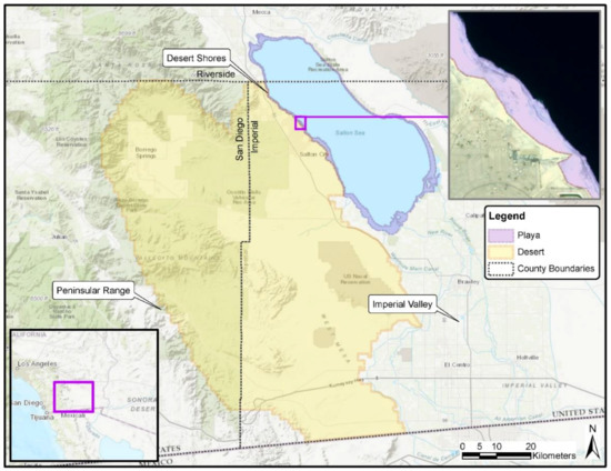
Figure 1.
Playa and desert study domains around the Salton Sea region. Sources: Esri, HERE, Garmin, Intermap, Increment P Corp., GEBCO, the U.S. Geological Survey (USGS), FAO, NPS, NRCAN, GeoBase, IGN, Kadaster NL, Ordnance Survey, Esri Japan, METI, Esri China (Hong Kong), © OpenStreetMap contributors, and the GIS User Community.
2.2. Field Campaign and Data Collection
The majority of the dataset was collected in field campaigns that were designed to provide ground-truth coupled with remote sensing data for surface parameterization within the playa study domain. All these data collected were utilized either as training data for model development or as validation data for an accuracy assessment in the next steps. A total of 17 ground-based surface survey campaigns were conducted in 104 days between June 2017 and May 2020 to characterize playa surfaces. These campaigns were designed to characterize surface properties related to dust emission potential in the study domain [56,57]. A standard set of survey data was collected during each field campaign to provide a consistent assessment of surface characteristics, including, but not limited to, crust type, soil moisture, and sand presence.
The desert study domain is not as dynamic or varying compared to the playa domain. It also covers a much greater spatial extent. Therefore, additional ground-truth points collected over 14 field campaigns on 39 days between June 2014 and April 2020 were utilized for the geomorphic mapping of the desert domain. Furthermore, additional points were selected by photo-interpretation informed by these ground-truth data and by random selection of points from maps previously developed by the California Geological Survey [63] in the area. Locations of the data collected are shown in Figure 2.
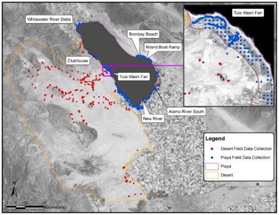
Figure 2.
Surface survey campaign locations in the playa and desert domains around the Salton Sea region. Landsat 8 image courtesy of the USGS.
2.3. Imagery Data and Processing
Two Pleiades satellite images, acquired in October 2018 and September 2019, were used to map the crust type and sand presence in the playa study domain. The Pleiades imagery provides orthorectified multispectral (blue, green, red, near-infrared [NIR]) data with spatial resolution of 2 m. The data were converted to top-of-atmosphere reflectance using the Radiometric Calibration routine in ENVI 5.4 software (Harris Geospatial Solutions, Inc., Boulder, CO, USA). Various band ratio indices related to spectral characteristics, vegetation, and soil crust were derived from the imagery [64,65,66]. Gray Level Co-occurrence Matrix (GLCM) values associated with image texture features were also calculated from the calibrated imagery. These index values were used as predictors in development of crust type and sand presence classifiers. Definitions and formulas of these various predictors are summarized in Table 1.

Table 1.
Features used in OBIA process and as predictors in machine learning base classification.
Observations collected with Operational Land Imager (OLI) onboard the Landsat 8 satellite were used for soil moisture mapping in the playa domain. Landsat 8 Collection 1 Level 2 data products were downloaded from the USGS between June 2018 and June 2020. Data from the SWIR 1 band (1570–1650 nm) were used in this study for soil moisture mapping. The images were visually inspected and screened for artifacts (e.g., clouds, haze, smoke) before analysis. Ultimately, 32 images collected between June 2018 and June 2020 were implemented.
Geomorphic surface mapping conducted in the desert domain utilized National Agriculture Imagery Program (NAIP) imagery. The NAIP imagery contains three bands (red, green, blue) in the visible spectral region. Alternative representation of true color images (hue, intensity, and saturation) was also calculated from the imagery. Additionally, 5 m spatial resolution NEXTMap Digital Terrain Model (DTM) data derived from airborne Interferometric Synthetic Aperture Radar (IFSAR) were acquired (NEXTMap, https://www.intermap.com/nextmap, accessed on 1 December 2021). The ortho-rectified 1 m resolution dataset representing the intensity of the SAR signal values used to generate the DTM was also acquired to provide additional information. The radar return intensity values were useful for the discrimination of surface-particle-size-based surface type classes (e.g., sand- vs. silt-dominated). Various terrain attributes (e.g., elevation, slope) were derived using the System for Automated Geoscientific Analyses GIS software (SAGA GIS, http://www.saga-gis.org, accessed on 20 November 2021) toolbox to provide environmental information related to soil and surface forming at landscape level. Detailed parameters used as predictors in desert geomorphic surface mapping can be found in Table 2.

Table 2.
Parameters used as predictors in desert geomorphic surface mapping.
2.4. Image Segmention
The Object-Based Image Analysis (OBIA) technique is often used to analyze remote sensing data [38,39]. In this study, the OBIA approach was used to segment an image into homogenous objects for crust type and sand mapping in the playa domain and geomorphic surface mapping in the desert domain, using Trimble eCognition Developer v9.4.0 x64 software (Trimble Inc., Sunnyvale, CA, USA). This product has been widely used in various studies related to classification and feature extraction from remote sensing data [68,69,70,71]. Individual multispectral imagery bands were imported into the software, and image segmentation was performed at several exploratory scales. An appropriate segmentation scale factor was chosen, which derived objects representative of the density of the training data and the size of playa features of interest. A scale factor is a unit-less factor that varies given the imagery resolution, bit depth, type, and other parameterized weighting. Derived objects within a single analysis event may vary in size and shape based on homogeneity of surface features. In subsequent analysis events, with identical input imagery specifications and parameterization, a common scale factor may be applicable, but should be evaluated specific to that event.
2.5. Machine Learning
Machine learning techniques have been widely utilized in land surface mapping and monitoring applications with remote sensing data in recent years as an effective and efficient approach [31,32,33,34,35]. Advantages of these machine learning algorithms include their capability to model complex class signatures, to accept a variety of input predictor data, and to not make assumptions about data distribution [31]. Machine learning algorithms are made available by the open-source H2O platform (H2O.ai, https://www.h2o.ai/, accessed on 10 November 2021) for straightforward access and implementation [72]. H2O enables the implementation of various machine learning, deep learning, and artificial intelligence algorithms including Random Forests (RF), Extremely Randomized Trees (XRT), Gradient Boosting Machines (GBM), and Neural Network (NN) algorithms [72,73,74,75]. This platform has been utilized in previous land surface mapping and monitoring studies with remote sensing data [32,34]. H2O’s Automatic Machine Learning (AutoML) framework evaluates and optimizes multiple learning algorithms (e.g., RF, GBM, NN) at once to attain better predictive performance. This framework was utilized in this study to develop classifiers for crust type and sand presence mapping in the playa domain, and geomorphic surface type mapping in the desert domain. Predictor parameters (Table 1 and Table 2) at field sampling locations were extracted for model development. Prior to model development, the entire dataset was partitioned into a training dataset and validation dataset. Considerations were given to balance the class distribution within the training dataset. Therefore, within the training dataset, each class contains approximately the same number of samples to ensure fair representation of each class. Only the training dataset was utilized in development of the various classifiers. During the development, models were instructed to stop after three rounds if the model failed to further reduce error. Performance of each model was assessed and reported using a confusion matrix with the training dataset and with the independent validation dataset.
2.6. Playa Soil Moisture Mapping
Soil moisture around the Salton Sea is subject to variation temporally and spatially due to precipitation events as well as infrequent flooding due to wave action during high wind events. An empirical model between the Landsat 8 SWIR 1 band (1570–1650 nm) and surface soil moisture was developed for the playa domain by gathering ground-truth and photo-interpretative points during two Landsat 8 overpasses on 11 June 2017 and 30 June 2018 [57]. A total of 469 points were used to develop the classifier of the empirical soil moisture model. Among the 469 points, 67 ground-truth points were focused on portions of the playa with shallow slope and diffuse moisture gradients. During the campaign, two soil moisture classes—“dry” (no soil moisture present) and “wet” (wilting point to field capacity or wetter)—were assessed in the field. The volumetric soil moisture content of the “dry” and “wet” classes was verified from 57 samples. The water content of the dry class was characterized as follows: lower quantile, median, and upper quantile of 0.9%, 2.4%, and 11.3% water by volume, respectively. The wet class was characterized as follows: lower quantile, median, and upper quantile of 15.3%, 22.8%, and 35.9% water by volume, respectively. A threshold of 0.33 for the Landsat 8 SWIR 1 values was identified as an appropriate classifier to differentiate between “dry” and “wet” surface soil moisture classes. Pixels with values higher than the threshold are classified as “dry” while the others are classified as “wet” [57]. This empirical model was applied to 32 images from June 2018 through June 2020 to provide soil moisture information (dry or wet) in the playa domain.
3. Results
Within the playa domain, small water bodies and playa vegetation were first delineated from open playa (bare soil) using Pleiades imagery. This was achieved using classifiers based on XRT by the AutoML procedure and visual inspection. Water bodies have strong absorption features across the visible and NIR spectral region while healthy vegetation contains unique spectral characteristics due to chlorophyll. These features make both classes clearly distinguishable from open playa.
3.1. Crust Type Mapping
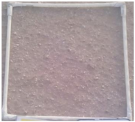
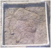
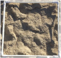
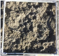
Playa surfaces are regularly characterized by partitioning unique surfaces into classes based on texture, relief, and landform. Classes and descriptors are often adjusted to account for unique conditions at a given playa. In this study, selected crust types were adapted from previous literatures to represent the unique playa surface conditions at the Salton Sea [4,17,25]. Five crust types represent the majority of the open playa area: no-crust, smooth, weak botryoidal, botryoidal, and barnacle beds. Descriptions and pictures of these distinctive crust types are shown in Table 3. These five crust types are the classes to identify and map in crust mapping analysis. The GBM model was selected by the AutoML procedure in H2O for surface crust mapping for the 2018 and 2019 images. The NDVI, the ratio of NIR to all bands, and the Zabud Index were the top three predictors for the October 2018 image, while mean NIR reflectance, NDVI, and the GLCM standard deviation were identified as the top three predictors for the September 2019 image. Crust type mapping results for September 2019 are shown in Figure 3. More detailed results and geomorphic features around the Bombay Beach area are shown in Figure 4. Detailed accuracy assessments for the classifications are reported in Table 4 and Table 5 for October 2018 and September 2019 images, respectively. With the training datasets, the crust type classification achieved an overall accuracy from 98.7% to 99.4%. The classifications were further verified using the independent validation dataset, and overall accuracy from 91.7% to 97.7% was achieved.

Table 3.
Description of crust types for playa surface mapping. The white frame in the pictures is 1 m by 1 m.
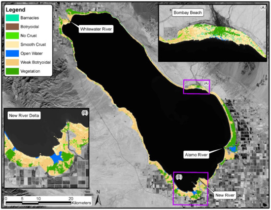
Figure 3.
Playa crust type distribution from September 2019. Landsat 8 image courtesy of the USGS.
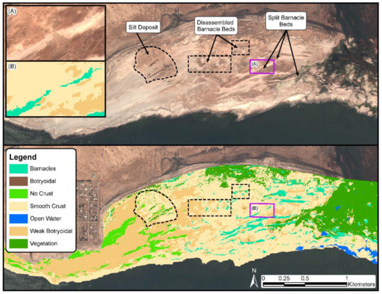
Figure 4.
Playa crust type distribution and geomorphic features around the Bombay Beach area from September 2019. Background image: Pleiades© CNES 2019, Distribution Airbus DS.

Table 4.
Confusion matrix for crust type classification for October 2018. Total sample size: training data = 2420; validation data = 171.

Table 5.
Confusion matrix for crust type classification for September 2019. Total sample size: training data = 4869; validation data = 659.
3.2. Sand Presence Mapping
For sand presence mapping in the playa domain, two classes—sand and no sand—were identified as important parameters to understand and estimate emissions within the area. Therefore, in this study, classification models were developed to map these two classes in the area. The GBM model was selected by the AutoML procedure in H2O to map sand presence for the 2018 and 2019 images. Sand presence was assessed in 10% surface cover intervals; the threshold between less than 10% was “no sand” and greater that 10% was “sand present.” These two groups provided a clear differentiation in dust emissions potential [56,57]. The Zabud Index, NIR, and NDVI were identified as the top three predictors for the October 2018 image, whereas the sum of visible bands, the ratio of the green band to all visible bands, and the blue reflectance were identified as the top three predictors for the September 2019 image. Sand presence mapping results in the playa domain for September 2019 are shown in Figure 5. Sand distribution associated with fluvial and aeolian sand sources in the western playa domain is also shown in Figure 5. Accuracy assessments for the classifications are reported in Table 6 and Table 7. With the training datasets, the sand presence classification achieved accuracy from 96.2% to 99.7%. The classifications were further verified using the independent validation datasets and achieved accuracy from 96.2% to 96.8%.
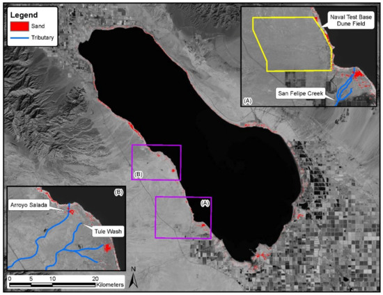
Figure 5.
Sand distribution in the playa domain and related fluvial and aeolian sand sources from September 2019. Landsat 8 image courtesy of the USGS.

Table 6.
Confusion matrix for playa sand presence for October 2018. Total sample size: training data = 1328; validation data = 249.

Table 7.
Confusion matrix for playa sand presence for September 2019. Total sample size: training data = 3132; validation data = 692.
3.3. Soil Moisture
An empirical model was applied on the Landsat 8 data SWIR 1 band to derive a surface soil moisture map within the playa domain as two classes: “dry” and “wet.” This threshold was selected to provide a more conservative view of wetness in the original design. This was later validated by a field campaign conducted on 15 April 2020. A total of 85 locations on the playa were visited, and soil moisture conditions were assessed. Among the 85 locations, 22 locations were identified as “dry,” while 63 locations were identified as “wet.” A corresponding Landsat 8 image from 16 April 2020 was analyzed using this empirical model described above. All 22 “dry” locations were classified as “dry” by the Landsat 8 imagery. Among the 63 “wet” locations, 44 locations were classified as “wet.” This is consistent with the development of the model to provide a conservative assessment of soil moisture, as described above. Overall, the model based on the Landsat 8 SWIR 1 band exhibited a 78% accuracy. A total of 32 Landsat 8 images collected from June 2018 to June 2020 were analyzed to create soil moisture maps. The annual average of wetness within the playa domain from July 2019 and June 2020 is shown in Figure 6. For each image analyzed, the ratio of the number of “wet” pixels to total pixels within the playa domain was calculated as playa percent wet. Temporal variation of playa percent wet is shown in Figure 7. Daily precipitation data were collected from two stations (#041 Calipatria/Mulberry; #218 Thermal South) of the California Irrigation Management Information System (CIMIS) stations and one station (Fish Creek Mountain California) from the Remote Automatic Weather Stations (RAWS) network around the Salton Sea area. Daily precipitation data were plotted and are shown in Figure 7.
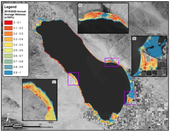
Figure 6.
Annual average wetness between July 2019 and June 2020 within the playa domain. Landsat 8 image courtesy of the USGS.
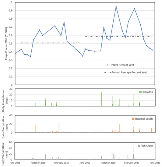
Figure 7.
Temporal variation of playa percent wet and daily precipitation information from nearby weather stations.
3.4. Desert Geographic Mapping
The desert domain in this study (Figure 1) consists of complex geomorphic surfaces. In the context of understanding dust emissions, the desert study domain was classified into landform-based classes and subclasses. Table 8 summarizes the classes and subclasses for the geomorphic mapping; it also displays whether each surface was determined to be emissive. These classes and subclasses were defined and slightly modified based on previous studies [76]. Examples of these subclasses are demonstrated in Figure 8. The geomorphic surface mapping was generated using a GBM model selected by the AutoML procedure. The most important variables in the prediction of subclasses were the diffuse insolation for the spring equinox, DTM, and ORI. The classification map is shown in Figure 9. Accuracy assessments of the classification are reported in Table 9, with training and validation datasets, respectively. Overall accuracy of the classification was 98.5% with the training data and 93.5% with the validation dataset.

Table 8.
Classes and subclasses for desert geomorphic surface characterization.
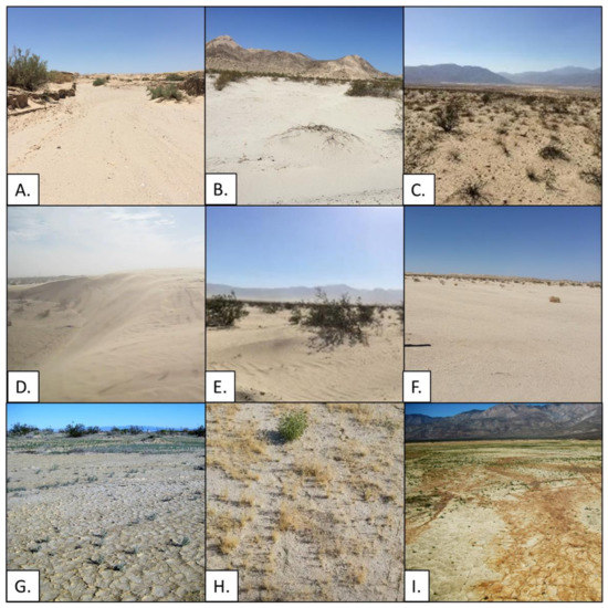
Figure 8.
Examples of desert surface types: (A) Dry Wash; (B) Sand-Dominated (Alluvial); (C) Sand and Gravel (Alluvial); (D) Sand Dunes; (E) Sand Sheet; (F) Sand with Gravel Lag; (G) Silt-Dominated (Paleolake); (H) Gravel and Sand (Paleolake); (I) Offshore Playa.
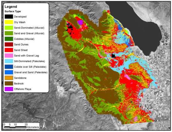
Figure 9.
Geomorphic surface mapping results in the desert domain. Landsat 8 image courtesy of the USGS.

Table 9.
Confusion matrix for geomorphic surface classification. Total sample size: training data = 102,725; validation data = 11,107.
4. Discussion
Dust emissions estimates and modeling is an interdisciplinary research that includes geomorphology, soil physics, meteorology, fluid dynamics, air chemistry, and ocean biology [3]. Remote sensing technologies and data provide a powerful tool to map and monitor wind erosion potential and to support dust emissions estimates. As part of an effort to improve our understanding of dust emissions around the Salton Sea region in Southern California (Figure 1) [56,57], this study reports remote sensing of land surface parameterization in support of dust emissions estimates. A series of studies and field campaigns has been conducted for multiple years within the playa and desert domain to measure dust emission potential and characterize surface conditions [56,57]. The measurements allowed us to establish the relationship between the dust emission potential and specific surface characteristics such as crust types, soil moisture, sand presence, and geomorphic surface types. These parameters were selected to be mapped for their strong influence on dust emissions [4,5,15,16,56,57] and because they can be scaled in a feasible manner from point data up to a regional landscape using remotely sensed data resources based on previous studies [22,23,26]. The relationship between these parameters and dust emission potential will then be applied to the mapping results to estimate dust emission potential within the study domain. More detailed information on the field campaigns, data analysis, and results can be found in relevant studies [56,57].
4.1. Remote Sensing Data and Classification
Crust types and sand presence were mapped for the playa study domain (Figure 1) on two dates in 2018 and 2019. Geomorphic surface types were classified for the desert study domain (Figure 1). These analyses were conducted using remote sensing data coupled with statistical machine learning techniques. Similar techniques for land surface and soil mapping have been reported in various studies previously. Quantitative remote sensing of soil properties, including organic matter, carbonate, and mineral content, though, can be challenging to achieve due to effects from vegetation cover, atmospheric conditions, spatial and spectral resolution of the data, provides the basis for this type of analysis [22,45]. Other geospatial data including topographical and environmental parameters can be applied to provide extra information and to improve accuracy [77]. Lacoste, Lemercier and Walter [77] used a regression tree-based algorithm to map soil parent material (SPM) in northwestern France. Land use data derived from Moderate Resolution Imaging Spectroradiometer (MODIS) and topographical attributes derived from 50 m Digital Elevation Model (DEM) data were utilized. Accuracy rates from 54% to 81% were reported from the study. Similarly, soil survey maps for approximately 85,000 ha in northern Iran were updated using machine learning techniques coupled with Landsat images and ASTER Global Digital Elevation Model (GDEM) data. The overall error between 48.5% to 56.6% was reported based on Soil Taxonomy great group, subgroup, and series levels [78]. ASTER data were also utilized with Support Vector Machine (SVM) data to map soil types in eastern Germany [79]. Overall accuracy of the classification varied based on training site distribution and input variable selection, and the best overall accuracy of 83% was reported [79]. Three statistical-based machine learning models (Weights of Evidence, Frequency Ratio, and Random Forest) were utilized with remote sensing data, including from Landsat and MODIS, to detect dust sources and to produce a dust source susceptibility map for northeastern Iran [20]. The analysis leveraged lithology, slope, soil, geomorphology, NDVI, and distance to water as input data. Accuracy from 82% to 91% using the training dataset and 81% to 88% using the validation dataset were reported, while Random Forest performed the best [20]. A semi-arid playa area in Bolivia was partitioned into four surface types— salty surface, silt-rich surface, clay-rich surface, and pure salt—using Landsat data and maximum likelihood classification [22]. Accuracies of 88% to 100% were reported based on training or validation datasets [22]. Identification of Biological Soil Crusts (BSCs) in the northwestern Negrev dunes across the Israel–Egypt border was studied [23]. Classification between BSCs and other four land surface types was performed using remote sensing data based Crust Index (CI), NDVI, and Thermal Curst Index (TCI) [23]. Overall accuracy of 86.2% was achieved when all three indices were utilized [23]. In this study, accuracy of at least 91.7% was achieved for the crust type and sand presence mapping in the playa domain and geomorphic surface mapping in the desert domain (Table 4, Table 5, Table 6, Table 7 and Table 9). In general, accuracies achieved in this study using either training or validation datasets were consistent with each other, while the errors were lower compared with previous soil mapping studies using similar techniques [20,77,78,79,80]. One factor may be the high-resolution remote sensing data utilized in the study. In contrast to Landsat (30 m) or MODIS data (250 m or 500 m), Pleiades imagery has a 2 m spatial resolution and, hence, a much smaller pixel size. Smaller pixels are less likely to contain mixed classes, and this may improve overall accuracy due to purity of the signal. Another factor may be the abundance of training data utilized in the study to capture the unique characteristics of the various classes.
4.2. Crust Development and Spatial Distribution on the Playa
In the playa study domain, development of crust types is a function of many contributing factors. It has been observed in situ that newly exposed playa surfaces begin as weak, unconsolidated, and smooth. Through the precipitation of salt, induced by the evaporation of saline water at the surface, the crust incrementally becomes strong, consolidated, and rough (botryoidal). Crust development generally occurs with the length of exposure, but its strength is affected by several factors, including mineralogy, precipitation, and erosion. Precipitation events dissolve salts and allow them to re-precipitate. Typically, after precipitation events, crusts degrade to the previous crust on the development sequence. For example, botryoidal crusts tend to become weak botryoidal crusts, and weak botryoidal crusts tend to become smooth crusts. Changes due to erosion (buffing and/or scouring) also usually represent a degradation on the development spectrum. These observations are generally consistent with crust development sequences recognized and reported in previous studies [26,81,82]. Relating the various factors to crust type distribution around the playa domain is a complex subject, and partitioning the impact of individual contributing factors is challenging and warrants further investigation.
Furthermore, geomorphological processes are another factor controlling the distribution of playa surface types and their erodibility [19,22]. Playa margins are a complex assemblage of geomorphic landforms (e.g., beach ridges, aeolian dunes, coastal spits and bars, deltas, splay systems) that can be used to interpret past depositional events (runoff, re-deposition, dune formation/encroachment) [83,84].
Areas of low relief are being exposed rapidly, particularly in near the New River and Whitewater River Deltas. This relatively rapid exposure generates an abundance of poorly developed smooth playa with diffuse contacts between playa crust types. Areas with intermediate relief, such as the Alamo River Delta, have been observed to have shallow, wave-cut terraces bounded by beach ridges formed by the fluctuating elevation of the Salton Sea. Beach ridges are a common playa feature, formed and subsequently abandoned by receding shorelines [84]. At these areas, laterally extensive stages of playa crust development are partitioned by linear beach ridges. Other portions of the playa with intermediate relief also exhibit shallow terraces, specifically the Tule Wash Fan and the playa bounded by Bombay Beach and the Niland Boat Ramp. Terraces at these locales are often delineated by barnacle bed beach ridges. Unlike the deltaic sites where sediment is delivered directly to the Sea by perennial rivers and redistributed by currents, these sites experience deposition events from ephemeral flow from broad sandy washes in the west and abundant, shallow, silty gulleys in the east. Sediment deposited by these flows is superimposed on Salton Sea playa deposits, adding complexity to the distribution of crust types. Fluvial deposition often forms smooth, brown, mud-cracked crusts that form next to playa-derived crusts.
Fluvial deposition often occurs on the upslope side of beach ridges. However, as accommodation space increases with the receding Salton Sea, fluvial processes can bisect beach ridge deposits, continue downslope, reworking playa surfaces and evening out terraces in the process. The chronology of these events is less apparent farther away from the shoreline, where degraded beach ridges become incorporated into the surrounding playa and their topography becomes more subdued. Buried ridges can often only be identified by a few barnacles on the surface or a strip of vegetation that has favored the relatively coarse, well-drained material. Examples of some of these geomorphic features are displayed in Figure 4. Areas with high relief that experience minimal exposure, specifically the eastern portion of the Sea north of Bombay Beach, are populated by beach zones that are characteristically less sensitive to the long-term regression of the Salton Sea due to their slow exposure rate.
4.3. Sand Presence
The migration of sand onto playa surfaces from external sources primarily occurs on the west side of the playa study domain. Aeolian deposition driven by strong westerly winds and fluvial deposits delivered by extensive, sand-laden, ephemeral creeks are the key mechanisms contributing to surficial sand deposits on the playa. A notable example of aeolian transport is the encroachment of the Salton Sea Dunes onto exposed playa surfaces at the Naval Test Base (Figure 5). Despite having a diminution in sand supply, the extensively characterized dune field has the capacity to deliver large amounts of sand onto playa surfaces [85,86,87,88]. The three primary tributaries on the west side of the Salton Sea include Arroyo Salada, Tule Wash, and San Felipe Creek (Figure 5). These tributaries deposit sediment across two alluvial fans, where sand is then available for aeolian redistribution. The larger of the two fans is located south of Salton City and is a composite of Arroyo Salada and Tule Wash (Figure 5). The San Felipe Fan is the smaller of the two fans, located approximately 15 km south (Figure 5). Sand deposited by these tributaries is distributed as diffuse sand drifts and linear strips of coppice dunes. Sand deposited onto playa surfaces is often reworked by longshore currents, swash zones, or aeolian activity. The quantity and extent of loose surficial sand deposits fluctuate as new deposition occurs, deposits are modified, or sand is sequestered via integration with developing salt crusts. Our results are generally consistent with the knowledge of sand deposition and movement in the region.
4.4. Soil Moisture
The assessment of soil moisture using remote sensing techniques has been studied for playa and desert surfaces at various spatial and temporal scales [89,90]. For instance, Levy and Johnson [89] developed a reflectance-based soil moisture index to monitor soil moisture fluctuations at Alvord Desert playa. Scheidt, Ramsey and Lancaster [90] assessed soil moisture at the White Sands Dune Field in New Mexico to build a relationship between potential soil erosion, soil moisture, and thermal inertia. Soil moisture within the playa study domain was assessed using Landsat 8 data with a 16-day revisit time in this study. Soil surface moisture is expected to exhibit greater temporal variation than crust types and sand presence because soil moisture is driven by frequency and intensity of precipitation and local weather conditions. Temporal variation of the soil moisture estimates from June 2018 through June 2020 are assessed in Figure 7. The percentage of the playa domain classified as wet (solid dotted line) is plotted and compared with daily precipitation data from three nearby meteorological stations (Figure 7). Precipitation measured at these stations reflects the late-summer to early-fall monsoonal and winter precipitation regimes that influence this region [91]. The frequency of events and annual totals from July 2019 and June 2020 were notably higher than those from the previous year for all stations. As one can observe in Figure 7, the temporal variation of soil moisture estimates agrees with the precipitation patterns. For instance, soil moisture estimates were higher in fall and winter months resulting from the significant influence of winter storms in these two years. Soil moisture estimates also responded to precipitation events, as expected. For example, playa percent wet increased significantly as a precipitation event occurred in fall 2019 after the dry summer months. Furthermore, average playa percent wet (dashed lines in Figure 7) between July 2019 and June 2020 was higher than the previous year, as the result of higher annual precipitation.
4.5. Desert Geomorphic Mapping
The desert landscape in our study domain was classified into various geomorphic surface types to improve our understanding of dust emissions in this region. Spatial extents of the various classes and subclasses are summarized in Table 10. Among the subclasses, bedrock and sand and gravel (alluvial) are the dominant subclasses within the region (Table 10). In Figure 10, the geomorphic surface map is compared with results from a previous mapping project by the California Geological Survey [63] conducted in this domain. The distribution and classification of these geomorphic surface mapping results are consistent with previous mapping efforts. Of the nine desert surface subclasses that are considered to contribute to dust emissions, the sand sheet, sand and gravel (alluvial), silt-dominated (paleolake), and dry wash subclasses account for the most acreage (Table 10). In a previous study around the region [4], dry washes, sand dunes, and distal alluvial fans were identified as the most emissive surfaces in the Salton Trough and the nearby Eastern Mojave Desert. Contrarily, silt/salt-crusted playas and desert pavements were identified as the least emissive surfaces. Although the sand sheets and the small coppice dunes superimposed upon them are not exactly the same as the Kelso Dune Field sampled in a previous study [4], all sand-dominated surfaces within the domain are considered to be emissive. Generally, two geomorphic assemblages are found to consistently produce windblown dust plumes. The first is the large contiguous sand sheets incised with wide, shallow, sandy dry washes, and the second is the outer fringes of alluvial fans where fine sand is deposited. Relatively non-emissive assemblages include the undisturbed silt-dominated (paleolake) surfaces and offshore playa surfaces. Both of these surfaces strongly resemble the relatively non-emissive silt-crusted Silver Lake playa sampled by Sweeney, McDonald and Etyemezian [4].

Table 10.
Spatial extents of geomorphic surface type subclasses in the desert study domain.
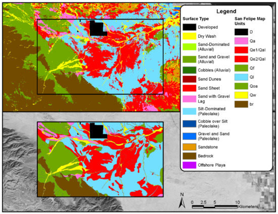
Figure 10.
Desert surface type (top panel) comparison with previous mapping results by California Geological Survey (2014) at (bottom panel). Landsat 8 image courtesy of the USGS.
One should note that there may be some uncertainties in the results presented in this study. For instance, while we leverage extensive field campaign and ground truthing in this study, as shown in Figure 2, there are regions that were not covered by the survey due to limitation of resources, landownership, and the extensive spatial coverage of the study site, especially in the desert domain. Since the data collected were utilized as training or validation data for the classification, the coverage of the data may inherently affect the results. Similar discussion on the impact of field survey distribution and coverage may be found in previous studies [92,93]. In addition, uncertainties may be brought in the results due to the satellite data quality [93], for instance, the Landsat data used in this study. Initial radiometric stability of better than 0.3% was reported [94] while a succeeding study reported temporal uncertainty of better than 0.5% for Landsat 8 data when using Pseudo Invariant Calibration Sites (PICS) [95]. This could be another source contributing uncertainties in the results reported in the study. Additional field campaigns and data analysis in the future may help to further validate the results and assess the uncertainties.
5. Conclusions
Dust emission is a complex process and can vary significantly in both spatial and temporal domains. In this study, we present a surface mapping framework for the exposed playa and desert domain near the Salton Sea in Southern California, USA. By leveraging extensive ground-truth data collection and site visits during multiple field campaigns across multiple years, important surface characteristics were defined to support dust emissions estimates in the region. This was accomplished by coupling remote sensing data with statistical machine learning algorithms. In general, good accuracies were achieved by this mapping framework. The results were consistent with site knowledge and related environmental and geomorphic characteristics. These surface characteristics in the playa and desert domains provide important land surface parameterizations that will allow the following: (1) the quantification of dust emissions within the region; (2) the identification of “hot spot” areas more susceptible to dust emissions; and (3) the ability to monitor the temporal variation of dust emissions within the region.
Author Contributions
Conceptualization, B.S., H.D. and Y.T.Y.; Y.-B.C., H.D. and B.P. contributed to the overall methodology, workflow development, analysis, and validation; data curation, H.D. and Y.-B.C.; H.D. and Y.-B.C. contributed to original draft writing and preparation, writing—review and editing, Y.-B.C., H.D., M.S. and Y.T.Y.; visualization, H.D. and R.T.; supervision, B.S., Y.T.Y. and Y.-B.C.; funding acquisition, B.S. All authors have read and agreed to the published version of the manuscript.
Funding
This research and writing was supported by the Imperial Irrigation District, Service Agreement No. 8100002362, funding is reimbursed by the Quantification Settlement Agreement Joint Powers Authority, who administers funding of environmental mitigation requirements related to the QSA water transfers. The views expressed herein do not necessarily reflect the views of the funding agencies.
Institutional Review Board Statement
Not applicable.
Informed Consent Statement
Not applicable.
Data Availability Statement
The data presented in this study are openly available in the following links. Salton Sea Air Quality Mitigation Program Documents: https://saltonseaprogram.com/aqm/team-documents.php (accessed on 1 December 2021) and Salton Sea Air Quality Mitigation Program Data Portal: https://saltonseaprogram.com/aqm/data-portal/data-portal.php# (accessed on 1 December 2021).
Acknowledgments
This study was conducted in support of the Imperial Irrigation District-Salton Sea Air Quality Mitigation Program (SSAQMP) and is part of a broader effort to quantify emissions from exposed playa and desert areas in the Salton Sea Airshed. The authors specifically thank Jessica Humes, Mark Sweeney, James King, William Porter, and Amato Evan as well as the anonymous reviewers of this manuscript for their very valuable guidance, input, suggestions, and critiques.
Conflicts of Interest
The authors declare that they have no known competing financial interests or personal relationships that could have appeared to influence the work reported in this paper.
References
- Von Holdt, J.; Eckardt, F.; Wiggs, G. Landsat identifies aeolian dust emission dynamics at the landform scale. Remote Sens. Environ. 2017, 198, 229–243. [Google Scholar] [CrossRef]
- IPCC. Climate Change 2013: The Physical Science Basis. Contribution of Working Group I to the Fifth Assessment Report of the Intergov-ernmental Panel on Climate Change; IPCC: Cambridge, UK; New York, NY, USA, 2013; p. 1535. [Google Scholar]
- Shao, Y.; Wyrwoll, K.-H.; Chappell, A.; Huang, J.; Lin, Z.; McTainsh, G.H.; Mikami, M.; Tanaka, T.Y.; Wang, X.; Yoon, S. Dust cycle: An emerging core theme in Earth system science. Aeolian Res. 2011, 2, 181–204. [Google Scholar] [CrossRef]
- Sweeney, M.R.; McDonald, E.V.; Etyemezian, V. Quantifying dust emissions from desert landforms, eastern Mojave Desert, USA. Geomorphology 2011, 135, 21–34. [Google Scholar] [CrossRef]
- Von Holdt, J.R.C.; Eckardt, F.D.; Baddock, M.C.; Wiggs, G.F.S. Assessing Landscape Dust Emission Potential Using Combined Ground-Based Measurements and Remote Sensing Data. J. Geophys. Res. Earth Surf. 2019, 124, 1080–1098. [Google Scholar] [CrossRef] [Green Version]
- Webb, N.P.; Strong, C.L. Soil erodibility dynamics and its representation for wind erosion and dust emission models. Aeolian Res. 2011, 3, 165–179. [Google Scholar] [CrossRef]
- Gillette, D.A. A qualitative geophysical explanation for “hot spot” dust emitting source regions. Contrib. Atmos. Phys. 1999, 72, 67–77. [Google Scholar]
- Mahowald, N.; Luo, C.; Del Corral, J.; Zender, C.S. Interannual variability in atmospheric mineral aerosols from a 22-year model simulation and observational data. J. Geophys. Res. Space Phys. 2003, D12, 108. [Google Scholar] [CrossRef] [Green Version]
- Bullard, J.; Baddock, M.; McTainsh, G.; Leys, J. Sub-basin scale dust source geomorphology detected using MODIS. Geophys. Res. Lett. 2008, 35, L15404. [Google Scholar] [CrossRef] [Green Version]
- Parajuli, S.P.; Yang, Z.-L.; Kocurek, G. Mapping erodibility in dust source regions based on geomorphology, meteorology, and remote sensing. J. Geophys. Res. Earth Surf. 2014, 119, 1977–1994. [Google Scholar] [CrossRef]
- Evan, A.T. Downslope Winds and Dust Storms in the Salton Basin. Mon. Weather. Rev. 2019, 147, 2387–2402. [Google Scholar] [CrossRef] [Green Version]
- Sweeney, M.R. Dust Emission Processes. In Treatise on Geomorphology, 2nd ed.; Elsevier: Amsterdam, The Netherlands, 2020. [Google Scholar]
- Li, J.; Okin, G.S.; Herrick, J.E.; Belnap, J.; Munson, S.M.; Miller, M.E. A simple method to estimate threshold friction velocity of wind erosion in the field. Geophys. Res. Lett. 2010, 37, L10402. [Google Scholar] [CrossRef]
- Shao, Y.; Lu, H. A simple expression for wind erosion threshold friction velocity. J. Geophys. Res. Earth Surf. 2000, 105, 22437–22443. [Google Scholar] [CrossRef]
- Buck, B.J.; King, J.; Etyemezian, V. Effects of Salt Mineralogy on Dust Emissions, Salton Sea, California. Soil Sci. Soc. Am. J. 2011, 75, 1971–1985. [Google Scholar] [CrossRef] [Green Version]
- King, J.; Etyemezian, V.; Sweeney, M.; Buck, B.J.; Nikolich, G. Dust emission variability at the Salton Sea, California, USA. Aeolian Res. 2011, 3, 67–79. [Google Scholar] [CrossRef]
- Sweeney, M.R.; Zlotnik, V.A.; Joeckel, R.M.; Stout, J.E. Geomorphic and hydrologic controls of dust emissions during drought from Yellow Lake playa, West Texas, USA. J. Arid Environ. 2016, 133, 37–46. [Google Scholar] [CrossRef] [Green Version]
- Cornelis, W.M.; Gabriels, D.; Hartmann, R. A Conceptual Model to Predict the Deflation Threshold Shear Velocity as Affected by Near-Surface Soil Water. Soil Sci. Soc. Am. J. 2004, 68, 1162–1168. [Google Scholar] [CrossRef]
- Motaghi, F.A.; Hamzehpour, N.; Abasiyan, S.M.A.; Rahmati, M. The wind erodibility in the newly emerged surfaces of Urmia Playa Lake and adjacent agricultural lands and its determining factors. Catena 2020, 194, 104675. [Google Scholar] [CrossRef]
- Boroughani, M.; Pourhashemi, S.; Hashemi, H.; Salehi, M.; Amirahmadi, A.; Asadi, M.A.Z.; Berndtsson, R. Application of remote sensing techniques and machine learning algorithms in dust source detection and dust source susceptibility mapping. Ecol. Inform. 2020, 56, 101059. [Google Scholar] [CrossRef]
- Rayegani, B.; Barati, S.; Goshtasb, H.; Gachpaz, S.; Ramezani, J.; Sarkheil, H. Sand and dust storm sources identification: A remote sensing approach. Ecol. Indic. 2020, 112, 106099. [Google Scholar] [CrossRef]
- Li, J.; Menenti, M.; Mousivand, A.; Luthi, S.M. Non-Vegetated Playa Morphodynamics Using Multi-Temporal Landsat Imagery in a Semi-Arid Endorheic Basin: Salar de Uyuni, Bolivia. Remote Sens. 2014, 6, 10131–10151. [Google Scholar] [CrossRef] [Green Version]
- Rozenstein, O.; Karnieli, A. Identification and characterization of Biological Soil Crusts in a sand dune desert environment across Israel–Egypt border using LWIR emittance spectroscopy. J. Arid Environ. 2015, 112, 75–86. [Google Scholar] [CrossRef]
- Reiche, M.; Funk, R.; Zhang, Z.; Hoffmann, C.; Reiche, J.; Wehrhan, M.; Li, Y.; Sommer, M. Application of satellite remote sensing for mapping wind erosion risk and dust emission-deposition in Inner Mongolia grassland, China. Grassl. Sci. 2012, 58, 8–19. [Google Scholar] [CrossRef]
- Sweeney, M.; Etyemezian, V.; MacPherson, T.; Nickling, W.; Gillies, J.; Nikolich, G.; McDonald, E. Comparison of PI-SWERL with dust emission measurements from a straight-line field wind tunnel. J. Geophys. Res. Space Phys. 2008, 113, F01012. [Google Scholar] [CrossRef]
- Milewski, R.; Chabrillat, S.; Behling, R. Analyses of Recent Sediment Surface Dynamic of a Namibian Kalahari Salt Pan Based on Multitemporal Landsat and Hyperspectral Hyperion Data. Remote Sens. 2017, 9, 170. [Google Scholar] [CrossRef] [Green Version]
- Jawak, S.D.; Devliyal, P.; Luis, A.J. A Comprehensive Review on Pixel Oriented and Object Oriented Methods for Information Extraction from Remotely Sensed Satellite Images with a Special Emphasis on Cryospheric Applications. Adv. Remote Sens. 2015, 4, 177–195. [Google Scholar] [CrossRef] [Green Version]
- Li, M.; Zang, S.; Zhang, B.; Li, S.; Wu, C. A Review of Remote Sensing Image Classification Techniques: The Role of Spatio-contextual Information. Eur. J. Remote Sens. 2014, 47, 389–411. [Google Scholar] [CrossRef]
- Li, X.; Chen, W.; Cheng, X.; Wang, L. A Comparison of Machine Learning Algorithms for Mapping of Complex Surface-Mined and Agricultural Landscapes Using ZiYuan-3 Stereo Satellite Imagery. Remote Sens. 2016, 8, 514. [Google Scholar] [CrossRef] [Green Version]
- Lu, D.; Weng, Q. A survey of image classification methods and techniques for improving classification performance. Int. J. Remote Sens. 2007, 28, 823–870. [Google Scholar] [CrossRef]
- Maxwell, A.E.; Warner, T.A.; Fang, F. Implementation of machine-learning classification in remote sensing: An applied review. Int. J. Remote Sens. 2018, 39, 2784–2817. [Google Scholar] [CrossRef] [Green Version]
- Abdi, A.M. Land cover and land use classification performance of machine learning algorithms in a boreal landscape using Sentinel-2 data. GIScience Remote Sens. 2020, 57, 1–20. [Google Scholar] [CrossRef] [Green Version]
- Belgiu, M.; Drăguţ, L. Random forest in remote sensing: A review of applications and future directions. ISPRS J. Photogramm. Remote Sens. 2016, 114, 24–31. [Google Scholar] [CrossRef]
- Burchfield, E.; Nay, J.J.; Gilligan, J. Application of machine learning to the prediction of vegetation health. ISPRS Int. Arch. Photogramm. Remote Sens. Spat. Inf. Sci. 2016, XLI-B2, 465–469. [Google Scholar] [CrossRef] [Green Version]
- Pal, M.; Foody, G.M. Evaluation of SVM, RVM and SMLR for Accurate Image Classification With Limited Ground Data. IEEE J. Sel. Top. Appl. Earth Obs. Remote Sens. 2012, 5, 1344–1355. [Google Scholar] [CrossRef]
- Myint, S.W.; Gober, P.; Brazel, A.; Grossman-Clarke, S.; Weng, Q. Per-pixel vs. object-based classification of urban land cover extraction using high spatial resolution imagery. Remote Sens. Environ. 2011, 115, 1145–1161. [Google Scholar] [CrossRef]
- Gallego, F.J. Remote sensing and land cover area estimation. Int. J. Remote Sens. 2004, 25, 3019–3047. [Google Scholar] [CrossRef]
- Blaschke, T. Object based image analysis for remote sensing. ISPRS J. Photogramm. Remote Sens. 2010, 65, 2–16. [Google Scholar] [CrossRef] [Green Version]
- Whiteside, T.; Ahmad, W. A comparison of object-oriented and pixel-based classification methods for mapping land cover in northern Australia. In Proceedings of the SSC2005 Spatial Intelligence, Innovation and Praxis: The National Biennial Conference of the Spatial Sciences Institute, Melbourne, VIC, Australia, 12–16 September 2005. [Google Scholar]
- Sadeghi, M.; Jones, S.B.; Philpot, W.D. A linear physically-based model for remote sensing of soil moisture using short wave infrared bands. Remote Sens. Environ. 2015, 164, 66–76. [Google Scholar] [CrossRef]
- Wang, L.; Qu, J.J. Satellite remote sensing applications for surface soil moisture monitoring: A review. Front. Earth Sci. China 2009, 3, 237–247. [Google Scholar] [CrossRef]
- Abulaiti, A.; Kimura, R.; Shinoda, M.; Kurosaki, Y.; Mikami, M.; Ishizuka, M.; Yamada, Y.; Nishihara, E.; Gantsetseg, B. An observational study of saltation and dust emission in a hotspot of Mongolia. Aeolian Res. 2014, 15, 169–176. [Google Scholar] [CrossRef]
- Dai, Y.; Zhang, C.; Cen, S.; Wang, X.; Liu, X.; Zhang, H. Abrasion of soil clods with different textures and moisture contents in sand flow environment. Aeolian Res. 2020, 46, 100614. [Google Scholar] [CrossRef]
- Sadeghi, M.; Babaeian, E.; Tuller, M.; Jones, S.B. The optical trapezoid model: A novel approach to remote sensing of soil moisture applied to Sentinel-2 and Landsat-8 observations. Remote Sens. Environ. 2017, 198, 52–68. [Google Scholar] [CrossRef] [Green Version]
- Ben-Dor, E. Quantitative remote sensing of soil properties. Adv. Agron. 2002, 75, 173–243. [Google Scholar]
- Ahmed, A.; Zhang, Y.; Nichols, S. Review and evaluation of remote sensing methods for soil-moisture estimation. SPIE Rev. 2011, 2, 028001. [Google Scholar] [CrossRef] [Green Version]
- Zhang, D.; Zhou, G. Estimation of Soil Moisture from Optical and Thermal Remote Sensing: A Review. Sensors 2016, 16, 1308. [Google Scholar] [CrossRef] [PubMed] [Green Version]
- Carlson, T. An Overview of the “Triangle Method” for Estimating Surface Evapotranspiration and Soil Moisture from Satellite Imagery. Sensors 2007, 7, 1612–1629. [Google Scholar] [CrossRef] [Green Version]
- Whiting, M.L.; Li, L.; Ustin, S.L. Predicting water content using Gaussian model on soil spectra. Remote Sens. Environ. 2004, 89, 535–552. [Google Scholar] [CrossRef]
- Al-Yaari, A.; Wigneron, J.-P.; Ducharne, A.; Kerr, Y.; de Rosnay, P.; de Jeu, R.; Govind, A.; Al Bitar, A.; Albergel, C.; Muñoz-Sabater, J.; et al. Global-scale evaluation of two satellite-based passive microwave soil moisture datasets (SMOS and AMSR-E) with respect to Land Data Assimilation System estimates. Remote Sens. Environ. 2014, 149, 181–195. [Google Scholar] [CrossRef] [Green Version]
- Ben-Dor, E.; Chabrillat, S.; Demattê, J.A.M.; Taylor, G.R.; Hill, J.; Whiting, M.L.; Sommer, S. Using Imaging Spectroscopy to study soil properties. Remote Sens. Environ. 2009, 113, S38–S55. [Google Scholar] [CrossRef]
- Weidong, L.; Baret, F.; Xingfa, G.; Qingxi, T.; Lanfen, Z.; Bing, Z. Relating soil surface moisture to reflectance. Remote Sens. Environ. 2002, 81, 238–246. [Google Scholar] [CrossRef]
- Lobell, D.B.; Asner, G.P. Moisture Effects on Soil Reflectance. Soil Sci. Soc. Am. J. 2002, 66, 722–727. [Google Scholar] [CrossRef]
- Nolet, C.; Poortinga, A.; Roosjen, P.; Bartholomeus, H.; Ruessink, G. Measuring and Modeling the Effect of Surface Moisture on the Spectral Reflectance of Coastal Beach Sand. PLoS ONE 2014, 9, e112151. [Google Scholar] [CrossRef]
- Muller, E.; Décamps, H. Modeling soil moisture-reflectance. Remote Sens. Environ. 2001, 76, 173–180. [Google Scholar] [CrossRef] [Green Version]
- Imperial Irrigation District (IID). Salton Sea Air Quality Mitigation Program; Full Report; Formation Environmental, LLC: Imperial, CA, USA, 2016. [Google Scholar]
- Imperial Irrigation District (IID). Annual Report and Emissions Estimates for 2019/2020, Salton Sea Emissions Monitoring Program; Salton Sea Air Quality Mitigation Program; Formation Environmental, LLC: Imperial, CA, USA, 2021. [Google Scholar]
- Etyemezian, V.; Nikolich, G.; Ahonen, S.; Pitchford, M.; Sweeney, M.; Purcell, R.; Gillies, J.; Kuhns, H. The Portable In Situ Wind Erosion Laboratory (PI-SWERL): A new method to measure PM10 windblown dust properties and potential for emissions. Atmos. Environ. 2007, 41, 3789–3796. [Google Scholar] [CrossRef]
- Barnum, D.A.; Bradley, T.; Cohen, M.; Wilcox, B.; Yanega, G. State of the Salton Sea—A Science and Monitoring Meeting of Scientists for the Salton Sea; U.S. Geological Survey: Sacramento, CA, USA, 2017. [Google Scholar]
- Xu, H. Modification of normalised difference water index (NDWI) to enhance open water features in remotely sensed imagery. Int. J. Remote Sens. 2006, 27, 3025–3033. [Google Scholar] [CrossRef]
- Duan, Z.; Bastiaanssen, W.G.M. Estimating water volume variations in lakes and reservoirs from four operational satellite altimetry databases and satellite imagery data. Remote Sens. Environ. 2013, 134, 403–416. [Google Scholar] [CrossRef]
- Ji, L.; Zhang, L.; Wylie, B. Analysis of Dynamic Thresholds for the Normalized Difference Water Index. Photogramm. Eng. Remote Sens. 2009, 75, 1307–1317. [Google Scholar] [CrossRef]
- California Geological Survey. Project Summary and Transmittal—CGS Identification of Surficial Processes for Desert Renewable Energy Conservation Plan (CDFW Ecosystem Processes Grant No. P1382002/01); California Department of Conservation: Sacramento, CA, USA, 2014. [Google Scholar]
- Chen, J.; Zhang, M.Y.; Wang, L.; Shimazaki, H.; Tamura, M. A new index for mapping lichen-dominated biological soil crusts in desert areas. Remote Sens. Environ. 2005, 96, 165–175. [Google Scholar] [CrossRef]
- Karnieli, A. Development and implementation of spectral crust index over dune sands. Int. J. Remote Sens. 1997, 18, 1207–1220. [Google Scholar] [CrossRef]
- Lewinski, S. Applying fused multispectral and panchromatic data of Landsat ETM+ to object oriented classification. In Proceedings of the 26th EARSeL Symposium, New Developments and Challenges in Remote Sensing, Warsaw, Poland, 29 May–2 June 2006; pp. 1–7. [Google Scholar]
- Haralick, R.M.; Shanmugam, K.; Dinstein, I.H. Textural Features for Image Classification. IEEE Trans. Syst. Man Cybern. 1973, SMC-3, 610–621. [Google Scholar] [CrossRef] [Green Version]
- Gupta, N.; Bhadauria, H.S. Object based Information Extraction from High Resolution Satellite Imagery using eCognition. Int. J. Comput. Sci. Issues (IJCSI) 2014, 11, 139–144. [Google Scholar]
- Benz, U.; Pottier, E. Object based analysis of polarimetric SAR data in alpha-entropy-anisotropy decomposition using fuzzy classification by eCognition. In Proceedings of the IGARSS 2001. Scanning the Present and Resolving the Future. Proceedings. IEEE 2001 International Geoscience and Remote Sensing Symposium (Cat. No.01CH37217), Sydney, NSW, Australia, 9–13 July 2001; pp. 1427–1429. [Google Scholar]
- Holt, A.C.; Seto, E.Y.; Rivard, T.; Gong, P. Object-based Detection and Classification of Vehicles from High-resolution Aerial Photography. Photogramm. Eng. Remote Sens. 2009, 75, 871–880. [Google Scholar] [CrossRef] [Green Version]
- Flanders, D.; Hall-Beyer, M.; Pereverzoff, J. Preliminary evaluation of eCognition object-based software for cut block delineation and feature extraction. Can. J. Remote Sens. 2003, 29, 441–452. [Google Scholar] [CrossRef]
- Cook, D. Practical Machine Learning with H2O: Powerful, Scalable Techniques for Deep Learning and AI; O’Reilly Media: Sebastopol, CA, USA, 2016. [Google Scholar]
- Aiello, S.; Eckstrand, E.; Fu, A.; Landry, M.; Aboyoun, P. Machine Learning with R and H2O, 4th ed.; Lanford, J., Ed.; H2O: Mountain View, CA, USA, 2015. [Google Scholar]
- Candel, A.; LeDell, E. Deep Learning with H2O, 6th ed.; Bartz, A., Ed.; H2O: Mountain View, CA, USA, 2020. [Google Scholar]
- LeDell, E.; Poirier, S. H2O AutoML: Scalable Automatic Machine Learning. In Proceedings of the 7th ICML Workshop on Automated Machine Learning, Online Conference, 17–18 July 2020. [Google Scholar]
- Goossens, D.; Buck, B. Dust emission by off-road driving: Experiments on 17 arid soil types, Nevada, USA. Geomorphology 2009, 107, 118–138. [Google Scholar] [CrossRef]
- Lacoste, M.; Lemercier, B.; Walter, C. Regional mapping of soil parent material by machine learning based on point data. Geomorphology 2011, 133, 90–99. [Google Scholar] [CrossRef]
- Rad, M.R.P.; Toomanian, N.; Khormali, F.; Brungard, C.W.; Komaki, C.B.; Bogaert, P. Updating soil survey maps using random forest and conditioned Latin hypercube sampling in the loess derived soils of northern Iran. Geoderma 2014, 232–234, 97–106. [Google Scholar] [CrossRef]
- Hahn, C.; Gloaguen, R. Estimation of soil types by non linear analysis of remote sensing data. Nonlinear Process. Geophys. 2008, 15, 115–126. [Google Scholar] [CrossRef]
- Forkuor, G.; Hounkpatin, O.K.L.; Welp, G.; Thiel, M. High Resolution Mapping of Soil Properties Using Remote Sensing Variables in South-Western Burkina Faso: A Comparison of Machine Learning and Multiple Linear Regression Models. PLoS ONE 2017, 12, e0170478. [Google Scholar] [CrossRef]
- Adams, K.D.; Sada, D.W. Surface water hydrology and geomorphic characterization of a playa lake system: Implications for monitoring the effects of climate change. J. Hydrol. 2014, 510, 92–102. [Google Scholar] [CrossRef]
- Tollerud, H.J.; Fantle, M.S. The temporal variability of centimeter-scale surface roughness in a playa dust source: Synthetic aperture radar investigation of playa surface dynamics. Remote Sens. Environ. 2014, 154, 285–297. [Google Scholar] [CrossRef]
- May, J.-H.; Barrett, A.; Cohen, T.; Jones, B.; Price, D.; Gliganic, L. Late Quaternary evolution of a playa margin at Lake Frome, South Australia. J. Arid Environ. 2015, 122, 93–108. [Google Scholar] [CrossRef] [Green Version]
- Wells, S.G.; Brown, W.J.; Enzel, Y.; Anderson, R.Y.; McFadden, L.D. Late Quaternary Geology and Paleohydrology Ofpluvial Lake Mojave, Southern California. In Paleoenvironments and Paleohydrology of the Mojave and Southern Great Basin Deserts; Enzei, Y., Wells, S.G., Lancaster, N., Eds.; Geological Society of America: Boulder, CO, USA, 2003; pp. 79–114. [Google Scholar]
- Haff, P.K.; Presti, D.E. Barchan Dunes of the Salton Sea Region, California. In Desert Aeolian Processes; Tchakerian, V.P., Ed.; Springer: Dordrecht, The Netherlands, 1995; pp. 153–177. [Google Scholar]
- Long, J.T.; Sharp, R.P. Barchan-dune movement in imperial Valley, California. GSA Bull. 1964, 75, 149–156. [Google Scholar] [CrossRef]
- Norris, R.M. Barchan Dunes of Imperial Valley, California. J. Geol. 1966, 74, 292–306. [Google Scholar] [CrossRef]
- Norris, R.M.; Norris, K.S. Algodones Dunes of Southeastern California. GSA Bull. 1961, 72, 605–619. [Google Scholar] [CrossRef]
- Levy, J.S.; Johnson, J.T.E. Remote Soil Moisture Measurement from Drone-Borne Reflectance Spectroscopy: Applications to Hy-droperiod Measurement in Desert Playas. Remote Sens. 2021, 13, 1035. [Google Scholar] [CrossRef]
- Scheidt, S.; Ramsey, M.; Lancaster, N. Determining soil moisture and sediment availability at White Sands Dune Field, New Mexico, from apparent thermal inertia data. J. Geophys. Res. Earth Surf. 2010, 115, F02019. [Google Scholar] [CrossRef]
- Comrie, A.C.; Glenn, E.C. Principal components-based regionalization of precipitation regimes across the southwest United States and Northern Mexico, with an application to monsoon precipitation variability. Clim. Res. 1998, 10, 201–215. [Google Scholar] [CrossRef]
- Shen, X.; Jiang, M.; Lu, X.; Liu, X.; Liu, B.; Zhang, J.; Wang, X.; Tong, S.; Lei, G.; Wang, S.; et al. Aboveground biomass and its spatial distribution pattern of herbaceous marsh vegetation in China. Sci. China Earth Sci. 2021, 64, 1115–1125. [Google Scholar] [CrossRef]
- Shen, X.; Liu, B.; Jiang, M.; Lu, X. Marshland Loss Warms Local Land Surface Temperature in China. Geophys. Res. Lett. 2020, 47, 087648. [Google Scholar] [CrossRef] [Green Version]
- Markham, B.; Barsi, J.; Kvaran, G.; Ong, L.; Kaita, E.; Biggar, S.; Czapla-Myers, J.; Mishra, N.; Helder, D. Landsat-8 Operational Land Imager Radiometric Calibration and Stability. Remote Sens. 2014, 6, 12275–12308. [Google Scholar] [CrossRef] [Green Version]
- Mishra, N.; Helder, D.; Barsi, J.; Markham, B. Continuous calibration improvement in solar reflective bands: Landsat 5 through Landsat 8. Remote Sens. Environ. 2016, 185, 7–15. [Google Scholar] [CrossRef] [Green Version]
Publisher’s Note: MDPI stays neutral with regard to jurisdictional claims in published maps and institutional affiliations. |
© 2022 by the authors. Licensee MDPI, Basel, Switzerland. This article is an open access article distributed under the terms and conditions of the Creative Commons Attribution (CC BY) license (https://creativecommons.org/licenses/by/4.0/).

