Article

Impacts of FY-4A GIIRS Water Vapor Channels Data Assimilation on the Forecast of “21·7” Extreme Rainstorm in Henan, China with CMA-MESO

1
CMA Earth System Modeling and Prediction Centre (CEMC), China Meteorological Administration, Beijing 100081, China
2
State Key Laboratory of Severe Weather (LaSW), Chinese Academy of Meteorological Sciences, China Meteorological Administration, Beijing 100081, China
*
Author to whom correspondence should be addressed.
Remote Sens. 2022, 14(22), 5710; https://doi.org/10.3390/rs14225710
Submission received: 21 October 2022 / Revised: 7 November 2022 / Accepted: 8 November 2022 / Published: 11 November 2022

Abstract

:
A record-breaking extreme rainstorm occurred in Henan Province of China on 20 July 2021. To investigate the impacts of the Geostationary Interferometric Infrared Sounder (GIIRS) data assimilation on model analysis and forecasts of this rainfall event, the high temporal resolution GIIRS water vapor (WV) channel data were assimilated in the high-resolution CMA-MESO (Mesoscale Weather Numerical Forecast System of China Meteorological Administration) in this study. The results showed that the GIIRS WV radiance assimilation could improve the model WV analysis, which in turn adjusted the distributions of hydrometeors (radar composite reflectivities) and wind field, and finally improved the precipitation forecast. Additionally, although barely any GIIRS observations were assimilated over the cloudy area, the precipitation forecast errors of “21·7” extreme rainstorm events could be reduced by improving the structure of atmospheric circulations through the assimilation of neighboring data around Henan, especially over the upstream region. With the GIIRS WV data assimilation, the location error of maximum 24-h accumulated precipitation forecasts decreased from 128.48 km to 28.97 km (improved by 77.45%) for the cold start at 0000 UTC (Universal Time Coordinated) on 19 July 2021, and it was also reduced by about 60.52% for the warm start experiment at 0600 UTC on 19 July 2021. In addition, the GIIRS assimilation experiment showed an extraordinarily heavy rainfall area (above 250 mm/24 h) around Zhengzhou station, which did not appear in the control experiment, and was closer to the observed extreme precipitation. This study demonstrates the potential value of geostationary hyperspectral infrared sounders data assimilation in extreme weather early warning and forecasting.

1. Introduction

Rainstorm forecasting is a recognized difficult problem in weather forecasting, particularly forecasting extreme rainstorms, due to their strong extremities, localities and variability [1]. Rainstorm disasters often bring great losses to the production and life of human society. Therefore, it is very important and necessary to study and improve the forecasting ability of such disastrous weather events. In recent years, with the developments in numerical modeling and observation systems, several studies used numerical weather prediction (NWP) to perform and improve rainstorm forecasting [2,3,4]. However, the NWP accuracy of local rainstorms is influenced by many factors, especially the uncertainty of initial conditions [5,6,7,8].
Data assimilation (DA), especially satellite data assimilation, is an important means to improve the model initial field and NWP accuracy [9,10,11,12]. The European Centre for Medium-Range Weather Forecasts (ECMWF) has shown that the hyperspectral observations from low-Earth orbit (LEO) satellites (e.g., the Atmospheric Infrared Sounder (AIRS), the Infrared Atmospheric Sounding Interferometer (IASI), the Cross-track Infrared Sounder (CrIS)) can improve the accuracy of model initial fields, and thus can improve prediction [13,14,15]. Yesubabu et al. [16] conducted six experiments (including the control experiment) to evaluate the impact of observations from different sources on the forecasting of torrential rainfall events. They demonstrated that the assimilation of satellite radiances data led to major changes in the thermodynamic fields of the model. These increments in temperature and humidity fields, in turn, modified the pressure and wind distributions, resulting in improvements in precipitation forecasting. Liu et al. [17] evaluated the impact on several tropical cyclone forecasts by radiances data assimilation of the Advanced Microwave Sounding Unit-A (AMSU-A), based on the Weather Research and Forecasting (WRF) Model. The results showed that compared with the reanalysis and dropwindsonde data, the assimilation of AMSU-A radiances could better describe the environmental field. Xu and Powell [8] assimilated the radiance observations of Advanced Television and Infrared Observation Satellite Operational Vertical Sounder (ATOVS) in the Gridpoint Statistical Interpolation (GSI) system. They found that the ATOVS assimilation could improve the model initial conditions, and reduce precipitation forecast errors. Xie et al. [3] improved the forecasting of precipitation intensity and distribution of the Beijing “7.21” heavy rainfall event, by assimilating the AMSU radiance observations. Zhang et al. [18] assimilated all-sky infrared (IR) and microwave radiance observations for Hurricane Harvey (2017), and the results showed that the forecasting errors of hurricane track, intensity and rainfall all decreased.
In particular, compared with the observations from LEO satellites, the observations from geostationary (GEO) satellites have higher temporal resolution, which can provide more continuous and detailed information than LEO data for the same region [4,19,20,21]. Wu et al. [22] improved the prediction of the Guangzhou “5·7” rainstorm event by assimilating the high temporal resolution radiance observations of AHI (Advanced Himawari Imager) from Himawari-8. For the “21·7” Henan extreme rainstorm (the case of this study), Xu et al. [4] carried out assimilation experiments of the water vapor (WV) clear-sky radiance data of AGRI (Advanced Geosynchronous Radiation Imager) onboard Fengyun-4A (FY-4A). The results showed that model humidity and wind fields were adjusted after AGRI assimilation, and finally, rainfall forecasts improved.
The Geostationary Interferometric Infrared Sounder (GIIRS) flying on FY-4A is the first high-spectral-resolution IR sounder onboard a GEO satellite in the world, which was launched on 11 December 2016. Compared with IR imagers, such as AGRI and AHI, GIIRS observations not only have the characteristics of high temporal resolution, but also have thousands of channels. The GIIRS can observe the three-dimensional (3D) atmospheric structure with high temporal resolution and high vertical resolution, and its ability to continuously monitor local atmospheric variations has great potential in the early warning and prediction of extreme weather [12,23]. Li et al., Wang et al. and Okamoto et al. [24,25,26] explained the advantages of the GEO hyperspectral IR sounder (GeoHIS), using a regional or hybrid Observing System Simulation Experiment (OSSE). Yin et al. [27] assimilated the GIIRS longwave (LW) observations in a global model, and showed the benefits of high temporal resolution for typhoon forecasting by improving the temperature analysis field, and adjusting the warm core structure of typhoons. However, they only considered the LW channels; furthermore, their contribution to the model WV field is limited. Therefore, in order to evaluate the impact of high-temporal-resolution hyperspectral IR sounder radiances on forecasting extreme rainfall events, the Mesoscale Weather Numerical Forecast System of China Meteorological Administration (CMA-MESO) was used to assimilate the GIIRS clear-sky WV radiances in this study. Then, its impact on extreme rainstorm forecasting was evaluated by taking the “21·7” Henan extreme rainstorm as an example.
From 17 to 23 July 2021, a record-breaking extreme rainstorm event occurred in many regions of Henan Province in central China (known as the “21·7” Henan extreme rainstorm). The coverage, with accumulated rainfall exceeding 250 mm, accounted for 32.8% of the total area of Henan Province, and the daily rainfall of 10 national meteorological observation stations has broken historical extremes, including Zhengzhou, Xinxiang, Kaifeng, Zhoukou and Luoyang. Among them, the daily rainfall of Zhengzhou national station (capital of Henan Province) reached 624.1 mm from 0000 UTC (Universal Time Coordinated) 20 July to 0000 UTC 21 July. Its hourly precipitation reached 201.9 mm from 0800 BJT (Beijing Time) to 0900 BJT on 20 July, setting a new record of hourly rainfall for the Chinese mainland; it became one of the “top ten weather and climate events at home and abroad in 2021”, according to the China Meteorological Administration (CMA) (http://www.cma.gov.cn/2011xwzx/2011xqxxw/2011xqxyw/202112/t20211229_589812.html?from=singlemessage (accessed on 10 November 2022), in Chinese). This disaster led to 398 deaths and missing persons, and direct economic losses of CNY 120.06 billion (https://mp.weixin.qq.com/s/eHimKyGdB2ggC1O_yE4djA (accessed on 10 November 2022), in Chinese).
This extreme rainstorm event concerned the scientific community, due to its wide range in precipitation, large accumulated rainfall, strong precipitation extremity, concentrated short-term heavy rainfall and long duration. Zhang et al. [28] and Su et al. [29] analyzed the observed phenomena and precipitation characteristics of this rainstorm, emphasizing the extremity of this precipitation event and the importance of further research. Yin et al. [30] discussed the cloud microphysical processes and dynamic mechanisms of this event based on WRF, and emphasized the importance of the well-organized meso-γ-scale convergent system. They claimed that the arc-shaped convergence zone caused superposition of WV from multiple directions, and this extreme rainstorm event was the joint result of cloud microphysical processes and dynamic processes in the convective system. Shi et al. [31] qualitatively analyzed the forecasting ability of the ECMWF (European Center for Medium- range Weather Forecasts), GFS (Global Forecast System) and PWAFS (Precision Weather Analysis and Forecasting System) regional models for this event, and pointed out that Typhoon “In-Fa” provided WV conditions for this extreme rainfall process. Xu et al. [4] analyzed the improvement effect of additional ocean observations that were provided by AGRI assimilation into the forecast of this disaster, and they also showed that Typhoon “In-Fa” provided WV conditions for this extreme rainstorm event. Their results provide a preliminary foundation for the study of this event.
Therefore, in order to study the potential values of GeoHIS data assimilation into extreme weather early warning and forecasting, this study mainly focuses on the assimilation of high-temporal-resolution GIIRS clear-sky WV radiance into the CMA-MESO, and its impact on the forecast for the “21·7” Henan extreme rainstorm forecast. The remainder of this study is organized as follows. In Section 2, GIIRS observations, CMA-MESO model and experimental design are introduced. Section 3 describes the precipitation observations of this case. Section 4 presents the increments to model after GIIIRS WV assimilation. Section 5 analyzes the forecast effect on the basis of Section 4, and conclusions are given in Section 6.

2. Data and Model

2.1. GIIRS Observations

The GIIRS onboard FY-4A is the first hyper-spectral instrument in GEO orbit, which can measure atmospheric temperature and humidity profiles with high resolution (temporally and vertically). It can achieve large-scale and rapid long-term observations, providing valuable information for global and regional NWPs. The GIIRS is a Michelson interferometer that scans the atmospheric structure with 1650 spectral channels. It has a spectral range of 700–2250 cm−1 at a spectral resolution of 0.625 cm−1, including long-wave infrared (LWIR) (700–1130 cm−1, 689 channels) and middle-wave infrared (MWIR) (1650–2250 cm−1, 961 channels) bands. The observation area of the GIIRS covers China and its surrounding areas (15°N–55°N; 70°E–140°E), with a spatial resolution of 16 km and a temporal resolution of 2 h [21].
This study analyzes and assimilates the WV information of MWIR bands. Figure 1a shows the overall bias characteristics of GIIRS MWIR channels 690–1650 (channels 1–689 are LWIR channels; the same below) during 15–17 July 2021, after quality control and cloud detection [32]. The red line indicates the average noise level NEDT (noise equivalent delta temperatures, NEΔT) of these channels; the black curve represents the mean bias; and the blue curve represents the standard deviation (STD) of the differences between observation and CMA-MESO simulation (O-B). Except for the contaminated channels (MWIR channels 720–890 and 1400–1650, with the NEDT almost above 0.4 K at 300 K), the STD of GIIRS MWIR channels is generally around 2 K. In addition, some anomalies exist in the observations of several MWIR channels, such as channel 693. Its wave number is 1651.875 cm−1 with low noise level (NEDT about 0.3 K at 300 K), and its mean bias is −0.82 K. However, it is obvious that the radiance observation of this channel is anomalous (as shown in Figure S1). Therefore, these channels (about 150 channels) need to be removed before performing channel selection. After eliminating the anomalous and contaminated channels, 49 channels are selected for assimilation using the entropy iteration method [33]. The channel selection results (Table S1) are marked with red dots in Figure 1b, and it includes the channels covering the upper, middle and lower troposphere (Figure 1c).

2.2. CMA-MESO

The high-resolution (3 km) CMA-MESO (Mesoscale Weather Numerical Forecast System of China Meteorological Administration) 3D-Var (three-dimensional variational assimilation) was used in this study [34]. The 3D-Var is static. The dynamic frame used in the CMA-MESO includes terrain following coordinates, a semi-implicit semi-Lagrangian difference scheme and a fully compressible non-static equilibrium dynamic frame. The physical parameterization schemes used are as follows: the WMS6 cloud physics scheme [35], the Rapid Radiative Transfer Model (RRTM) longwave radiance scheme and Dudhia shortwave radiance scheme [36,37], the Monin–Obukhov near surface layer scheme [38]; the Noah land-surface processes scheme [39], and the Medium-Range Forecast Model (MRF) boundary layer scheme and vertical diffusion scheme [40]. Note that no cumulus parameterization scheme was adopted. The integration step was 30 s, and the analysis and prediction fields of NCEP (National Centers for Environmental Prediction) were used for the cold-start background field and boundary conditions. In addition, radar observations were used in the assimilation system via the cloud analysis scheme [41]. The simulated area of the CMA-MESO covered 70°E–145°E, 10°N–60.1°N, with a horizontal resolution of 0.03 ° × 0.03 °, and it had 50 vertical model levels.

2.3. Experimental Design

Since the extreme rainstorm event mainly occurred on 20 July 2021, considering the demand for forecast timeliness, in this study we began the assimilation experiments from 0000UTC on 19 July (cold-start), and then we conducted the warm-start every 3 h until 0600 UTC on 19 July. The forecast period was 48 h. The NCEP GFS analysis field at 0000 UTC was used as the background field for the cold-start, and the 3 h forecast of the CMA-MESO analysis field was used as the background for the warm-start. To evaluate the effects of GIIRS WV data assimilation on the forecast for the “21·7” Henan extreme rainstorm, two experiments were conducted, namely a control experiment (simplified as CTRL) and a GIIRS WV assimilation experiment (simplified as GIIRS). With reference to the operational assimilation system of the CMA, the CTRL experiment assimilated conventional observations (including AIREP, TEMP, SHIP and SYNOP), GPSPW, GPSREF, VAD and SATOB. The GIIRS experiment assimilated the same data as CTRL, as well as the clear-sky GIIRS radiance from 49 WV channels (Table S2).
The GIIRS used in this study was the Version3 data [42], which has greatly improved spectral calibration. The thinning mesh for GIIRS radiances was every 50 km. The bias correction (BC) for the GIIRS was based on its fields of view (FOVs) biases; more details about GIIRS preprocessing (e.g., hamming apodization, cloud detection) and BC steps can be found in Yin et al. [32]. In addition, a background check based on the differences between observations and simulations (|O-B| < 3 K) was used in the quality control (QC).

3. Precipitation Observation

Figure 2a shows the 24-h accumulated precipitation on 20 July 2021. The observed precipitation data were taken from national meteorological stations of the CMA. The maximum precipitation occurred at Zhengzhou station (113.66°E, 34.71°N), with a 24-h accumulated precipitation of 624.1 mm. Figure 2b shows the hourly rainfall of Zhengzhou station and the whole of Henan Province (accumulated observed precipitation from national meteorological stations in the black box of Figure 2a) from 19 to 23 July, represented by the red bar and black bar, respectively. During 19 to 20 July 2021, precipitation increased gradually in Henan Province. On 20 July, Zhengzhou experienced the maximum hourly precipitation of 201.9 mm during 0800–0900 UTC; meanwhile, it was not the time of the maximum areal hourly precipitation in Henan Province, nor did it even correspond to the period when the areal hourly precipitation was decreasing in Henan. After 1000 UTC on 20 July, the areal hourly precipitation in Henan Province increased again, with the maximum areal hourly precipitation (652.6 mm) occurring during 1300–1400 UTC; then, the areal hourly precipitation decreased with fluctuations until 23 July. The possible reason for this is that the WV gradually gathered over Zhengzhou before 1000 UTC on 20 July, resulting in the extreme hourly precipitation of 201.9 mm [30]. After the maximum hourly precipitation in Zhengzhou, the WV moved and diffused to the northeast of Henan Province (Figure 3). The precipitation in Henan Province increased with larger rainfall area. After the maximum areal hourly precipitation in Henan, the WV gradually moved out of Henan Province. Therefore, this study mainly focused on the observations and forecasts on 20 July 2021.
Radar reflectivity observations are closely related to the atmospheric WV information. To better understand atmospheric WV transport and convection development, Figure 3 shows the radar composite reflectivity (dBZ) data that were observed on 20 July 2021, which were calculated using three-dimensional reflectivity mosaics from the CMA. As can be seen, the movement of WV in Henan Province is clearly reflected during this period. At 0000 UTC, a wide range of strong radar echoes appeared over Henan Province, which corresponded to the heavy precipitation in Figure 2b. At 0900 UTC (Figure 3b), which is the time of maximum hourly precipitation at Zhengzhou station and minimum areal hourly precipitation in Henan, there was an obvious strong echo in Zhengzhou; meanwhile, there were only a few scattered echoes in Henan Province. After that, the coverage of strong radar echoes became larger again and moved to the northeast of Henan Province. The widest strong echo region (greater than 45 dBZ) can be seen in Figure 3c. Subsequently, the echo centers gradually moved out of Henan, and gradually decreased after 2400 UTC on 20 July.
In addition, IR brightness temperature (TBB) observations from window channels can reflect cloud top temperatures, and can well indicate the development of convection systems [22,43,44]. The TBB observed by the GIIRS LWIR window channel 362 (926.25 cm−1) on 20 July 2021 is shown in Figure S2. The weak convection and deep convection systems are represented by −32 °C (red contour) and −52 °C (blue contour) thresholds, respectively [22,43]. As can be seen, the deep convection area has a good correspondence with the strong radar echoes in Figure 3. There was an obvious deep convection system in Zhengzhou during 0800–0900 UTC, and the coverage of the deep convection system (blue contour) became larger after 1000 UTC. After that, the convection system gradually moved to the northeast of Henan, and finally left Henan.

4. Analysis Results

The initial fields of forecast (or background/first-guess fields) can be adjusted by satellite observations through DA, and the model atmospheric fields at the analysis time can be affected directly by observations. Thus, the O-B from MWIR channel 967 (1823.125 cm−1, with a humidity Jacobian peak of around 400 hPa) and its corresponding humidity field increment were analyzed and discussed below, in order to better understand the impacts of the GIIRS WV radiance measurements. Figure 4 displays the difference in the humidity analysis fields between the GIIRS and CTRL experiments (GIIRS–CTRL) at 400 hPa, after the single channel 967 assimilated at 0000 UTC on 19 July 2021. Note that Figure 4 shows the results of single channel assimilation, not the assimilation scheme of forecast in Section 5. The reason for this was to avoid the interaction of each model level, and to more clearly illustrate the influence of the GIIRS MWIR channel on the model. Obviously, only the model grid points with the GIIRS observations assimilated nearby had increments, and the grids with large humidity increments were consistent with the locations of large differences between GIIRS observations and simulations; this indicated the rationality and correctness of the experiment in this study. In addition, the negative O-B of WV channel meant that the observation was wetter than the model simulation. Thus, the negative O-B in Figure 4 corresponded to a positive humidity increment, indicating that the GIIRS MWIR radiances could bring additional MW information to the model. Therefore, the assimilation of GIIRS MWIR channels is expected to improve the initial fields of the forecasting model, thereby improving precipitation forecasting.
The difference in humidity analysis fields between the CTRL and GIIRS (49 WV channels assimilated) experiments at 500 hPa are shown in Figure 5c, and the regional distributions of O-B after BC and QC of MWIR channel 1046 (1872.5 cm−1, with a humidity Jacobian peak of around 500 hPa) and channel 1202 (1970.0 cm−1, with a humidity Jacobian peak of around 700 hPa) are shown in Figure 5a and Figure 5b, respectively. Considering the large biases of the GIIRS MWIR bands (Figure 1), the cloud detection and QC scheme adopted in this study were relatively strict. Therefore, it can be seen from Figure 5 that the data finally entering the assimilation system were mainly distributed on the clear-sky continents in the north and southeast of China. In Henan Province and the western Pacific, the GIIRS observations were basically rejected due to the deep cloud systems, and as can be seen, there was no increment in the corresponding position (Figure 5c). Nonetheless, the observations in the neighboring airflows were also important for forecasting [4], especially for extreme rainstorms, where the peripheral pressure and wind fields are very influential factors. From the wind field distribution at 0000 UTC on 19 July 2021 (black barb in Figure 5c), it can be seen that Henan is dominated by southeasterly wind. There was an obvious positive WV increment in Anhui and Jiangsu Provinces, which were the clear-sky areas of the upstream of Henan Province. Therefore, through the integration and prediction of models, the increased WV in Jiangsu and Anhui would enter Henan via the southeasterly wind, which provides the possibility to improve the extreme precipitation forecast on 20 July.

5. Forecast Results

5.1. Geopotential Height and Wind Forecasts

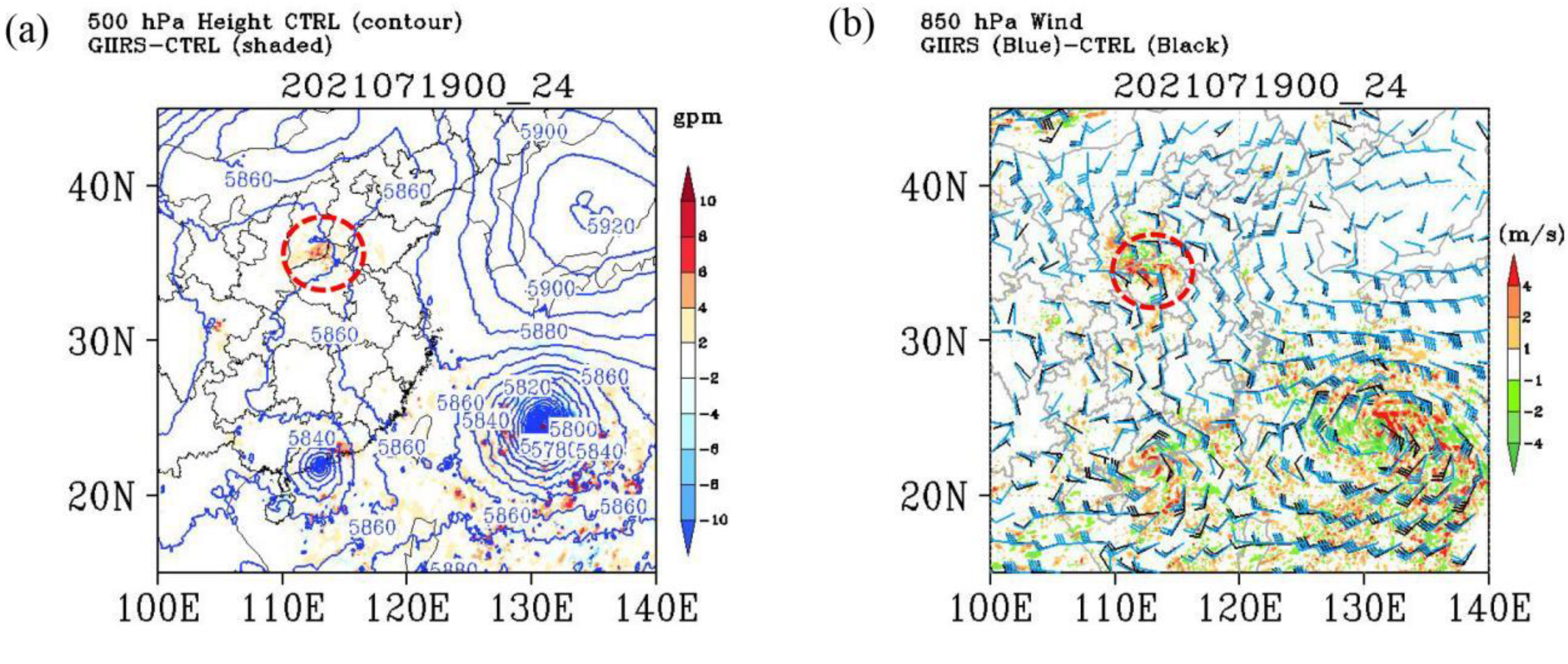
The differences in analysis increment (Figure 5c) led to different trends in the forecasts of circulation fields. In order to depict the forecast impact after GIIRS WV assimilation, Figure 6 shows the Geopotential height (GH) and wind fields at 0000 UTC on 20 July 2021, which is the 24-h forecast field after GIIRS assimilation. As can be seen, there was a significant GH increase in northern Henan, which meant that the subtropical high pressure was stronger in the GIIRS experiment than in the CTRL experiment. Therefore, the WV could be transported more westerly in the GIIRS experiment, and thus the precipitation center in the GIIRS was also more westerly. The blue and black barbs in Figure 6b describe the wind field of the GIIRS and CTRL at 850 hPa, respectively. Their speed differences are shown using color-shaded areas. Compared with the CTRL experiment, the wind speed in the northeast of Henan Province increased after GIIRS WV channels assimilation, with the maximum increment exceeding 4 m/s. Additionally, the 850 hPa wind forecast field of the CTRL was basically easterly wind (and southeasterly wind) in Henan Province. After the GIIRS WV assimilation, the northeasterly wind appeared in the north of Henan (blue barbs in Figure 6b), forming a horizontal wind shear (near Zhengzhou) with the southeasterly wind in the west of Henan. Thus, convection development in the GIIRS experiment was more vigorous than that in the CTRL experiment. The model wind field adjusted by GIIRS WV information assimilation could bring benefits to location forecasting of precipitation centers.

5.2. Water Vapor Flux Forecasts

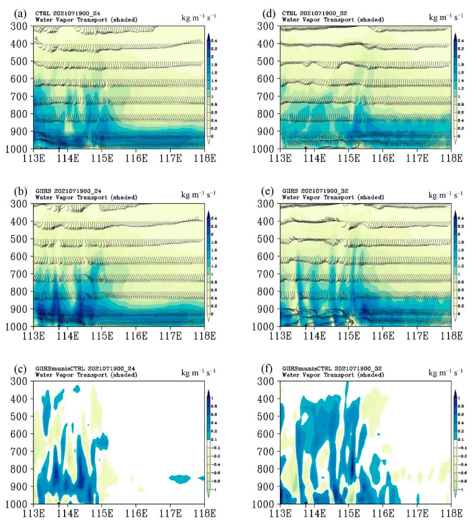
A persistent supply of water vapor is one of the necessary conditions for heavy rainstorms [29]. Analyzing the model water vapor flux was helpful to understand the influence of GIIRS WV assimilation on extreme precipitation forecasting. Figure 7 shows the vertical cross-sections of water vapor flux along 34.71°N in the 24-h and 32-h forecast fields that were initialized from 0000 UTC on 19 July 2021. Zhengzhou Station is indicated by the black arrow on the horizontal axis. The high-value areas of water vapor flux were mostly distributed below 700 hPa, because the atmospheric water vapor was distributed in the middle and lower layers. It can be seen from Figure 7b that the water vapor flux of the GIIRS experiment was deep and wet around 900 hPa near Zhengzhou. The differences between the two experiments proves that the WV flux in Henan Province (113°–115°E) increased obviously after GIIRS assimilation (Figure 7c). This provides favorable water vapor conditions for the occurrence of an extreme precipitation event on July 20 in Henan.
At 0800 UTC on 20 July 2021, the time of the maximum hourly precipitation in Zhengzhou (Figure 2), the WV flux of the CTRL experiment was weak and basically less than 2 kg m−1 s−1 (Figure 7d). Meanwhile, in the GIIRS experiment (Figure 7e), it can be seen that there was an obvious wet layer near Zhengzhou that extended from the ground to about 600 hPa, which was consistent with the extreme hourly rainfall (201.9 mm) in Zhengzhou at that time. As shown in Figure 7f, the WV flux increased obviously after GIIRS WV channels assimilation. The wet layer in Henan, especially in Zhengzhou, became deeper and thicker, extending to more than 500 hPa, which made it possible to improve the precipitation forecast.

5.3. Vertical Wind Forecasts

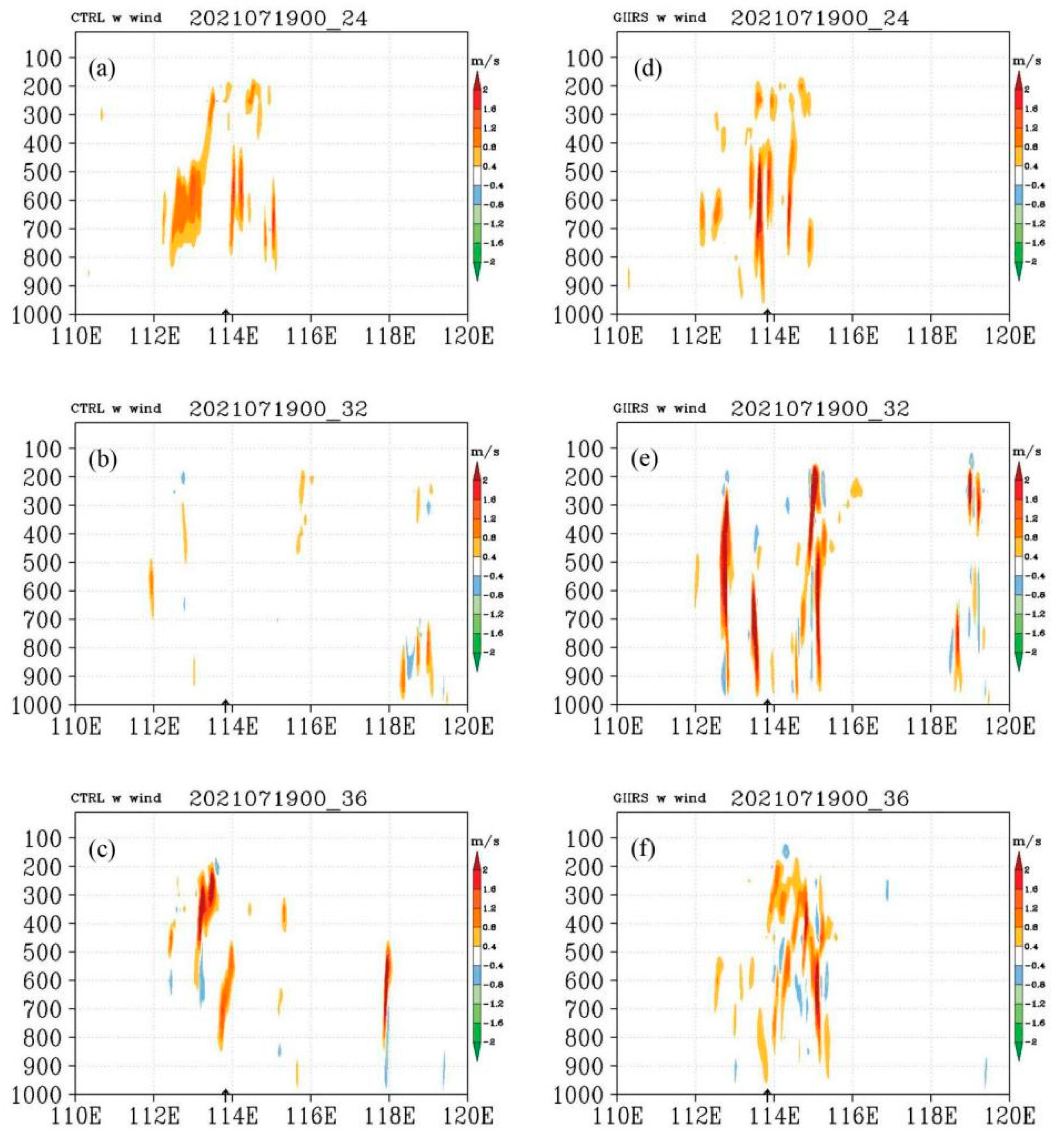
Yin et al. [30] pointed out that in the “21·7” extreme rainstorm event, a large amount of water vapor was transported to the upper layer through the updraft flows of the convective system to form precipitation particles, which was conducive to the formation of extreme precipitation. Therefore, analyzing the forecast of vertical wind (w wind) is also helpful to understand the influence of the GIIRS water vapor information assimilation on the precipitation forecast. The vertical cross-sections of w wind along 34.71°N in the CTRL experiment (left panel) and the GIIRS experiment (right panel) are shown in Figure 8. The same as Figure 7, the black arrow on the horizontal axis indicates Zhengzhou Station. Figure 8a–c (also for Figure 8d–f) represent the 24-h, 32-h and 36-h forecast fields initialized from 0000 UTC 19 July 2021, respectively. Generally, the w wind of the CTRL experiment was obviously weaker than that of the GIIRS experiment. Especially, during the period of maximum hourly precipitation at Zhengzhou, there was an obvious updraft near Zhengzhou Station after GIIRS assimilation (Figure 8e), but it did not appear in the CTRL experiment (Figure 8b). These results show that the wind field can be adjusted and improved by the WV assimilation, which indicates the importance of GIIRS assimilation. Similarly, before the time of maximum areal hourly precipitation in Henan Province, Figure 8c shows that the vertical motion of the CTRL experiment appeared only around 113°E, while it covered a wider region (east of 113°E, almost covering the whole of Henan Province) after GIIRS assimilation, which is consistent with the reflectivity distributions in Figure 9 below.

5.4. Radar Composite Reflectivity Forecasts

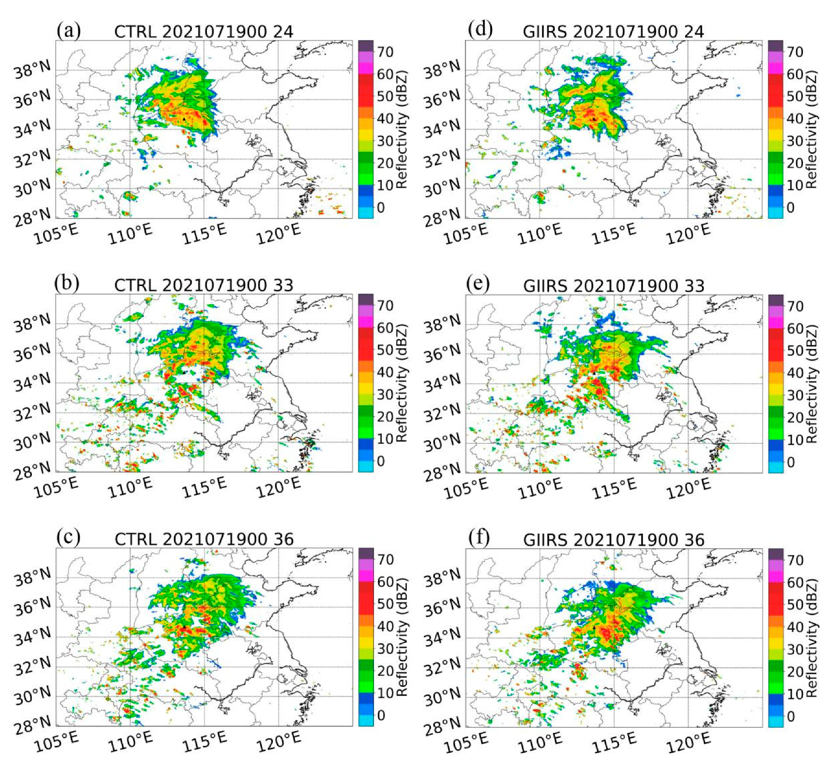
As revealed by Tong et al. [45], there is a significant correlation between radar reflectivity and model w wind. A region with strong reflectivity often corresponds to the maximum updraft of the model. It can also be seen that Figure 8 and Figure 9 have a good corresponding relationship. In addition, radar reflectivity reflects the distribution of atmospheric hydrometeors, so the location of precipitation can be indicated directly by the radar reflectivity [22]. Figure 9 displays the model-predicted radar composite reflectivity, with Zhengzhou Station indicated by the black triangle. Compared with the CTRL forecasts (left panel), the GIIRS-predicted (right panel) echo is stronger and wider, indicating the superiority of GIIRS WV assimilation in this case. The strong convection center predicted by the CTRL experiment (Figure 9a) was near 115°E, and the intensity of echo was weaker than the observed reflectivity in Figure 3. After GIIRS assimilation, the area of the strong echo center was larger, and it was basically in the north of Henan (Figure 9d), which was closer to the actual weather conditions. At 0900 UTC on 20 July 2021 (the time of the maximum hourly precipitation at Zhengzhou station), there was no obvious large reflectivity area near Zhengzhou in the CTRL prediction, and the echo distribution was relatively scattered in Henan Province (Figure 9b). After GIIRS assimilation (Figure 9e), a strong echo appeared near Zhengzhou, and the echoes in Henan were more intensive and extensive than those in CTRL, which is closer to the echo distribution in Figure 3b. Figure 9c,f roughly correspond to the period of maximum areal hourly precipitation in Henan Province. Compared with the actual echo reflectivity (Figure 3c), the reflectivity of the CTRL experiment as significantly weaker, and there was basically no large area of strong echoes in Henan Province. However, the echo intensity increased, and the echoes covered larger areas after GIIRS assimilation. The echo center predicted by the GIIRS (Figure 9f) was near 114°E, which was slightly more eastward than the actual situation. We can infer that the precipitation area of the GIIRS may have been located on the east side of the observed precipitation.

5.5. Precipitation Forecasts

The GIIRS WV data assimilation can adjust the initial field and forecast field of the model, which may improve the precipitation forecast through the above analysis. Precipitation forecasting is a comprehensive part in evaluating the assimilation effects. The distributions of 24-h accumulated precipitation from 0000 UTC 20 July to 0000 UTC 21 July 2021 of the forecasts by the two experiments are shown in Figure 10. Figure 10a,b are the 24–48 h forecasts from the cold-start at 0000 UTC on 19 July 2021. (c) and (d) are the 18–42 h forecasts from the warm-start at 0600 UTC on 19 July 2021. The black dot represents the position of the maximum precipitation forecast center of the model.
The observed maximum 24-h accumulated precipitation was 624.1 mm at Zhengzhou station (113.66°E, 34.71°N). Compared with the observations (Figure 2), the center of the predicted maximum precipitation in the CTRL experiment was generally eastward, which was also reflected in the predicted radar reflectivity in Figure 9. It can be seen in Figure 10a that in the CTRL experiment, rainfall above 250 mm did not appear around Zhengzhou station, the rainfall was less than that in the GIIRS experiment, and much less than the observations. The GIIRS experiment presented some scattered areas with precipitation above 250 mm around Zhengzhou station, with a maximum value of 331.5 mm (Figure 10b). This was a substantial improvement compared with the CTRL experiment, although the accumulated precipitation was still lower than the observations. In addition, after cycle assimilation, from the warm-start at 0600 UTC on 19 July 2021, the predicted precipitation was much less than observed due to the increasing forecast error with model integration. The simulated 24-h accumulated rainfall of the CTRL experiment was lower than 250 mm in Henan Province (Figure 10c), with a maximum value of 237.55 mm. However, there was an area with a 24-h accumulated precipitation above 250 mm in the GIIRS experiment (Figure 10d). The maximum 24-h accumulated rainfall of the GIIRS experiment reached 295.45 mm, and increased by about 14.98%. The location of the maximum rainfall center was near Zhengzhou station, which was closer to that from the observations.
Furthermore, from the ETS (Equitable Threat Score) in Figure S3, the scores of heavy rainfall (≥100 mm/24 h) and extraordinarily heavy rainfall (≥250 mm/24 h) improved after GIIRS assimilation. The results indicate that simulated 24-h accumulated precipitation after GIIRS assimilation improved compared with the CTRL experiment, especially in terms of the location of the precipitation center. The forecast error of the location of maximum 24-h accumulated precipitation improved by 77.45% (from 128.48 km to 28.97 km) and 60.52% (from 147.05 km to 58.06 km) for the cold-start at 0000 UTC on 19 July 2021 and the warm-start at 0600 UTC on 19 July 2021, respectively, which shows the advantage and potential value of GIIRS assimilation in forecasting extreme rainstorm events.

6. Conclusions

This study analyzed the impacts of GIIRS WV channels data assimilation on the model forecast effects for the “21·7” Henan extreme rainstorm event. The clear-sky radiance of 49 GIIRS WV channels was assimilated into the CMA-MESO, and a control experiment was conducted for comparison. The results show that the assimilation of GIIRS WV information improved the water vapor field, as well as the w wind and radar composite reflectivity. Seen from the forecast of the water vapor flux at each layer along 34.71°N (Zhengzhou station), water vapor development of the model became deeper and thicker after the GIIRS WV data were assimilated, which makes it possible to improve precipitation forecasting.
The atmospheric circulation (mainly wind field) was adjusted through the WV data assimilation of the GIIRS. The precipitation center that was predicted by the GIIRS experiment is more accurate than that by the CTRL experiment due to the stronger and more westward subtropical high pressure, as well as the stronger w wind. Compared with precipitation observations from national meteorological stations, the GIIRS WV radiance assimilation improved the forecasting of 24-h accumulated precipitation in terms of the rainfall intensity and location, especially for heavy precipitation. The forecast error of the location of maximum 24-h accumulated precipitation from the cold-start at 0000 UTC on 19 July 2021 decreased from 128.48 km to 28.97 km (improved by about 77.45%) after GIIRS assimilation, which indicates the application potential of the GIIRS in precipitation forecasting, as expected by past studies [24,25,26,46]. We hope this study can provide some reference and confidence for the application of GIIRS water vapor channel assimilation.
In addition, the spatial distribution of assimilated data shows that the GIIRS data used in this study were mostly distributed over land, due to strict quality control and cloud detection. There was almost no data assimilated over Henan Province because there were many cloud systems (strong convection). However, due to the adjustment of the model wind field by the assimilation of water vapor data in neighboring areas, precipitation forecasting in Henan was improved, especially for the center of maximum precipitation. Xu et al. [4] and Su et al. [29] have shown that Typhoon “In-Fa” in the ocean provided sufficient water vapor for the precipitation in this case. It also can be seen in Figure S4 that the model integrated water vapor transport that came mainly from the areas of Typhoon “In-Fa”. However, there was a very small humidity increment in the cloudy ocean in the GIIRS experiment, because the assimilated data were mostly over land, which may be the reason why rainfall location prediction improved more obviously, and that the improvement in precipitation intensity forecasting was smaller. Therefore, in the assimilation and prediction of high-impact events, such as typhoons and extreme rainfall, observational information in cloudy areas is very important. It is necessary to consider the direct assimilation of cloudy area data, or the assimilation of cloud-cleared radiances, which will be carried out in our future research.

Supplementary Materials

The following supporting information can be downloaded at: https://www.mdpi.com/article/10.3390/rs14225710/s1, Figure S1: Spatial distributions of radiance observation for MWIR channel 693 (1651.875 cm−1); Figure S2: Spatial distributionS1s of brightness temperature observation for LWIR window channel 362 (926.25 cm−1) on 20 July 2021; Figure S3: The ETS scores of predicted 24-h accumulated precipitation during 0000 UTC 20 July 2021 to 0000 UTC 21 July 2021 of the CTRL experiment (blue bar) and the GIIRS experiment (red bar) from cold-start at 0000 UTC 19 July 2021 (a) and warm-start at 0600 UTC 19 July 2021 (a); Figure S4: The integrated water vapor transport (kg m−1 s−1) of the CTRL (a) experiment and the GIIRS (b) experiment at 0000 UTC on 20 July 2021 (24-h forecast from 0000 UTC, 19 July 2021); Table S1: GIIRS MWIR channel selected in this paper; Table S2: The data assimilated into the CTRL and GIIRS experiments.

Author Contributions

Conceptualization, W.H. and R.Y.; methodology, J.W.; software, H.W.; validation, R.Y. and H.W.; formal analysis, R.Y.; investigation, R.Y.; writing—original draft preparation, R.Y.; writing—review and editing, R.Y.; visualization, R.Y.; supervision, R.Y.; project administration, W.H. and R.Y.; funding acquisition, W.H. and R.Y. All authors have read and agreed to the published version of the manuscript.

Funding

This study has been jointly supported by the National Natural Science Foundation of China (grant nos. 42075155, U2142201, 42175082).

Data Availability Statement

GIIRS satellite data are available at http://satellite.nsmc.org.cn/PortalSite/Data/DataView.aspx?currentculture=en-US (accessed on 10 November 2022); The NCEP reanalysis data can been found at http://rda.ucar.edu/datasets/ds083.2/ (accessed on 10 November 2022).

Acknowledgments

We appreciate the National Satellite Meteorological Center of the China Meteorological Administration for their technical support on the GIIRS data processing. We are also very grateful to the reviewers for their careful review and very valuable comments, which led to substantial improvements to this manuscript.

Conflicts of Interest

The authors declare no conflict of interest.

References

  1. Li, Z.C.; Chen, Y.; Zhang, F.H. Consideration by “75·8” extreme heavy rainfall event in Henan. Meteorol. Environ. Sci. 2015, 38, 1–12, (In Chinese with English Abstract). [Google Scholar]
  2. Charlton-Perez, C.; Cloke, H.L.; Ghelli, A. Rainfall: High-resolution observation and prediction. Meteorol. Appl. 2015, 22, 1–2. [Google Scholar] [CrossRef]
  3. Xie, Y.; Xing, J.; Shi, J.; Dou, Y.; Lei, Y. Impacts of radiance data assimilation on the Beijing 7.21 heavy rainfall. Atmos. Res. 2016, 169, 318–330. [Google Scholar] [CrossRef]
  4. Xu, L.; Cheng, W.; Deng, Z.R.; Liu, J.J.; Wang, B.; Lu, B.; Wang, S.D.; Dong, L. Assimilation of the FY-4A AGRI clear-sky radiance data in a regional numerical model and its impact on the forecast of the “21·7” Henan extremely persistent heavy rainfall. Adv. Atmos. Sci. 2022; in press. [Google Scholar] [CrossRef]
  5. William, A.; Gallus, J.R.; Bresch, J.F. Comparison of impacts of WRF dynamic core, physics package, and initial conditions on warm season rainfall forecasts. Mon. Weather Rev. 2006, 134, 2632–2641. [Google Scholar]
  6. Etherton, B.; Santos, P. Sensitivity of WRF forecasts for South Florida to initial conditions. Weather. Forecast. 2008, 23, 725–740. [Google Scholar] [CrossRef] [Green Version]
  7. Biazeto, B.; Dias, M.A.F.S. Analysis of the impact of rainfall assimilation during LBA atmospheric mesoscale missions in Southwest Amazon. Atmos. Res. 2012, 107, 126–144. [Google Scholar] [CrossRef]
  8. Xu, J.J.; Powell, A.M. Dynamical downscaling precipitation over Southwest Asia: Impacts of radiance data assimilation on the forecasts of the WRF-ARW model. Atmos. Res. 2012, 111, 90–103. [Google Scholar] [CrossRef]
  9. English, S.J.; Renshaw, R.J.; Dibben, P.C.; Smith, A.J.; Rayer, P.J.; Poulsen, C.; Saunders, F.W.; Eyre, J.R. A comparison of the impact of TOVS and ATOVS satellite sounding data on the accuracy of numerical weather forecasts. Q. J. R. Meteorol. Soc. 2000, 126, 2911–2931. [Google Scholar]
  10. Rakesh, V.; Singh, R.; Pal, P.K.; Joshi, P.C. Impacts of satellite-observed winds and total precipitable water on WRF short-range forecasts over the Indian region during the 2006 summer monsoon. Weather Forecast. 2009, 24, 1706–1731. [Google Scholar] [CrossRef]
  11. Eyre, J.R.; English, S.J.; Forsythe, M. Assimilation of satellite data in numerical weather prediction. Part I: The early years. Q. J. R. Meteorol. Soc. 2020, 146, 49–68. [Google Scholar] [CrossRef]
  12. Eyre, J.R.; Bell, W.; Cotton, J.; English, S.J.; Forsythe, M.; Healy, S.B.; Pavelin, E.G. Assimilation of satellite data in numerical weather prediction. Part II: Recent years. Q. J. R. Meteorol. Soc. 2022, 148, 521–556. [Google Scholar] [CrossRef]
  13. McNally, A.P.; Watts, P.D.; Smith, J.A.; Engelen, R.; Kelly, G.A.; Thépaut, J.N.; Matricardi, M. The assimilation of AIRS radiance data at ECMWF. Q. J. R. Meteorol. Soc. 2006, 132, 935–957. [Google Scholar] [CrossRef]
  14. Collard, A.D.; McNally, A.P. The assimilation of infrared atmospheric sounding interferometer radiances at ECMWF. Q. J. R. Meteorol. Soc. 2009, 135, 1044–1058. [Google Scholar] [CrossRef]
  15. Engelen, R.J.; Bauer, P. The use of variable CO2 in the data assimilation of AIRS and IASI radiances. Q. J. R. Meteorol. Soc. 2014, 140, 958–965. [Google Scholar] [CrossRef]
  16. Yesubabu, V.; Srinivas, C.V.; Langodan, S.; Hoteit, I. Predicting extreme rainfall events over Jeddah, Saudi Arabia: Impact of data assimilation with conventional and satellite observations. Q. J. R. Meteorol. Soc. 2016, 142, 327–348. [Google Scholar] [CrossRef] [Green Version]
  17. Liu, Z.Q.; Schwartz, C.S.; Snyder, C.; Ha, S.Y. Impact of assimilating AMSU—A radiances on forecasts of 2008 Atlantic tropical cyclones initialized with a limited-area ensemble Kalman filter. Mon. Weather Rev. 2012, 140, 4017–4034. [Google Scholar] [CrossRef] [Green Version]
  18. Zhang, Y.; Sieron, S.B.; Lu, Y.; Chen, X.; Nystrom, R.G.; Minamide, M.; Chan, M.; Hartman, C.M.; Yao, Z.; Ruppert, J.R., Jr.; et al. Ensemble-based assimilation of satellite all-sky microwave radiances improves intensity and rainfall predictions for Hurricane Harvey (2017). Geophys. Res. Lett. 2021, 48, e2021GL096410. [Google Scholar] [CrossRef]
  19. Schmit, T.J.; Gunshor, M.M.; Menzel, W.P.; Gurka, J.J.; Li, J.; Bachmeier, A.S. Introducing the next-generation advanced baseline imager on GOES-R. Bull. Am. Meteor. Soc. 2005, 86, 1079–1096. [Google Scholar] [CrossRef]
  20. Schmit, T.J.; Li, J.; Ackerman, S.A.; Gurka, J.J. High-spectral- and high-temporal-resolution infrared measurements from geostationary orbit. J. Atmos. Ocean. Technol. 2009, 26, 2273–2292. [Google Scholar] [CrossRef] [Green Version]
  21. Yang, J.; Zhang, Z.Q.; Wei, C.Y.; Lu, F.; Guo, Q. Introducing the new generation of Chinese geostationary weather satellites, Fengyun-4. Bull. Am. Meteorol. Soc. 2017, 98, 1637–1658. [Google Scholar] [CrossRef]
  22. Wu, Y.; Liu, Z.; Li, D. Improving forecasts of a record-breaking rainstorm in Guangzhou by assimilating every 10-min AHI radiances with WRF 4DVAR. Atmos. Res. 2020, 239, 104912. [Google Scholar] [CrossRef]
  23. Schmetz, J. Good things need time: Progress with the first hyperspectral sounder in geostationary orbit. Geophys. Res. Lett. 2021, 48, e2021GL096207. [Google Scholar] [CrossRef]
  24. Li, Z.; Li, J.; Wang, P.; Lim, A.; Li, J.; Schmit, T.J.; Atlas, R.; Boukabara, S.; Hoffman, R.N. Value-added impact of geostationary hyperspectral infrared sounder on local severe storm forecasts—Via a quick regional OSSE. Adv. Atmos. Sci. 2018, 35, 1217–1230. [Google Scholar] [CrossRef]
  25. Wang, P.; Li, Z.; Li, J.; Schmit, T.J. Added-value of GEO-hyperspectral infrared radiances for local severe storm forecasts using the Hybrid OSSE method. Adv. Atmos. Sci. 2021, 38, 1315–1333. [Google Scholar] [CrossRef]
  26. Okamoto, K.; Owada, H.; Fujita, T.; Kazumori, M.; Otsuka, M.; Seko, H.; Ota, Y.; Uekiyo, N.; Ishimoto, H.; Hayashi, M.; et al. Assessment of the potential impact of a hyperspectral infrared sounder on the Himawari follow-on geostationary satellite. Sci. Online Lett. Atmos. 2020, 16, 162–168. [Google Scholar] [CrossRef]
  27. Yin, R.; Han, W.; Gao, Z.; Li, J. Impact of high temporal resolution FY-4A Geostationary Interferometric Infrared Sounder (GIIRS) radiance measurements on Typhoon forecasts: Maria (2018) case with GRAPES global 4D-Var assimilation system. Geophys. Res. Lett. 2021, 48, e2021GL093672. [Google Scholar] [CrossRef]
  28. Zhang, X.; Yang, H.; Wang, X.M.; Shen, L.; Wang, D.; Li, H. Analysis on characteristic and abnormality of atmospheric circulations of July 2021 extreme precipitation in Henan. Trans. Atmos. Sci. 2021, 44, 672–687, (In Chinese with English Abstract). [Google Scholar] [CrossRef]
  29. Su, A.; Lü, X.; Cui, L.; Li, Z.; Xi, L.; Li, H. Prediction and test of optimal integrated precipitation based on similar spatial distribution of precipitation. Torrential Rain Disasters 2021, 40, 445–454, (In Chinese with English Abstract). [Google Scholar] [CrossRef]
  30. Yin, J.F.; Gu, H.D.; Liang, X.D.; Yu, M.; Sun, J.; Xie, Y.; Li, F.; Wu, C. A possible dynamic mechanism for rapid production of the extreme hourly rainfall in Zhengzhou City on 20 July 2021. J. Meteor. Res. 2022, 36, 6–25. [Google Scholar] [CrossRef]
  31. Shi, W.R.; Li, X.; Zeng, M.J.; Zeng, M.; Zhang, B.; Wang, H.; Zhu, K.; Zhuge, X. Multi-model comparison and high-resolution regional model forecast analysis for the “7·20” Zhengzhou Severe Heavy Rain. Trans. Atmos. Sci. 2021, 44, 688–702, (In Chinese with English Abstract). [Google Scholar] [CrossRef]
  32. Yin, R.; Han, W.; Gao, Z.; Di, D. The evaluation of FY4A’s Geostationary Interferometric Infrared Sounder (GIIRS) long-wave temperature sounding channels using the GRAPES global 4D-Var. Q. J. R. Meteorol. Soc. 2020, 146, 1459–1476. [Google Scholar] [CrossRef]
  33. Yin, R.; Han, W.; Gao, Z.; Wang, G. A study on longwave infrared channel selection based on estimates of background errors and observation errors in the detection area of FY-4A. Acta Meteorol. Sin. 2019, 77, 898–910, (In Chinese with English abstract). [Google Scholar] [CrossRef]
  34. Shen, X.S.; Wang, J.J.; Li, Z.C.; Chen, D.H.; Gong, J.D. Research and operational development of numerical weather prediction in China. J. Meteorol. Res. 2020, 34, 675–698. [Google Scholar] [CrossRef]
  35. Hong, S.Y.; Lim, K.S.; Kim, J.H. The WRF single-moment 6-class microphysics scheme (WSM6). J. Korea Meteo 2006, 42, 129–151. [Google Scholar]
  36. Mlawer, E.J.; Taubman, S.J.; Brown, P.D.; Iacono, M.J.; Clough, S.A. Radiative transfer for inhomogeneous atmospheres: RRTM, a validated correlated-k model for the longwave. J. Geophys. Res. Atmos. 1997, 102, 16663–16682. [Google Scholar] [CrossRef] [Green Version]
  37. Dudhia, J. Numerical study of convection observed during the winter monsoon experiment using a mesoscale two-dimensional model. J. Atmos. Sci. 1989, 46, 3077–3107. [Google Scholar] [CrossRef]
  38. Beljaars, A.C.M.; Holtslag, A.A.M. Flux parameterization over land surfaces for atmospheric models. J. Appl. Meteor. 1991, 30, 327–341. [Google Scholar] [CrossRef]
  39. Ek, M.B.; Mitchell, K.E.; Lin, Y.; Rogers, E.; Grunmann, P.; Koren, V.; Gayno, G.; Tarpley, J.D. Implementation of Noah land surface model advances in the National Centers for Environmental Prediction operational mesoscale Eta model. J. Geophys. Res. Atmos. 2003, 108, 8851. [Google Scholar] [CrossRef]
  40. Hong, S.Y.; Pan, H.L. Nonlocal boundary layer vertical diffusion in a medium-range forecast model. Mon. Weather Rev. 1996, 124, 2322–2339. [Google Scholar] [CrossRef]
  41. Xue, M.; Droegemeier, K.K.; Wong, V. The Advanced Regional Prediction System (ARPS)—A multi-scale nonhydrostatic atmospheric simulation and prediction model. Part Ⅰ: Model dynamics and verification. Meteor. Atmos. Phys. 2000, 75, 161–193. [Google Scholar] [CrossRef]
  42. Guo, Q.; Chen, B.; Wang, X.; Han, C.; Hui, W.; Xu, W.; Wen, R. Spectrum Calibration of the First Hyperspectral Infrared Measurements from a Geostationary Platform: Method and Preliminary Assessment. Q. J. R. Meteorol. Soc. 2021, 147, 1562–1583. [Google Scholar] [CrossRef]
  43. Maddox, R.A. Mesoscale convective complexes. Bull. Am. Meteorol. Soc. 1980, 61, 1374–1387. [Google Scholar] [CrossRef]
  44. Zheng, Y.; Chen, J.; Chen, M.; Wang, Y.; Ding, Q. Statistic characteristics and weather significance of infrared TBB during May–August in Beijing and its vicinity. Chin. Sci. Bull. 2007, 5, 3428–3435. [Google Scholar] [CrossRef]
  45. Tong, M.; Xue, M. Ensemble Kalman filter assimilation of Doppler radar data with a compressible nonhydrostatic model: OSS experiments. Mon. Weather Rev. 2005, 133, 1789–1807. [Google Scholar] [CrossRef]
  46. World Meteorological Organization. Vision for the WMO Integrated Global Observing System in 2040; WMO-TD: Geneva, Switzerland, 2019; Volume 1243. [Google Scholar]
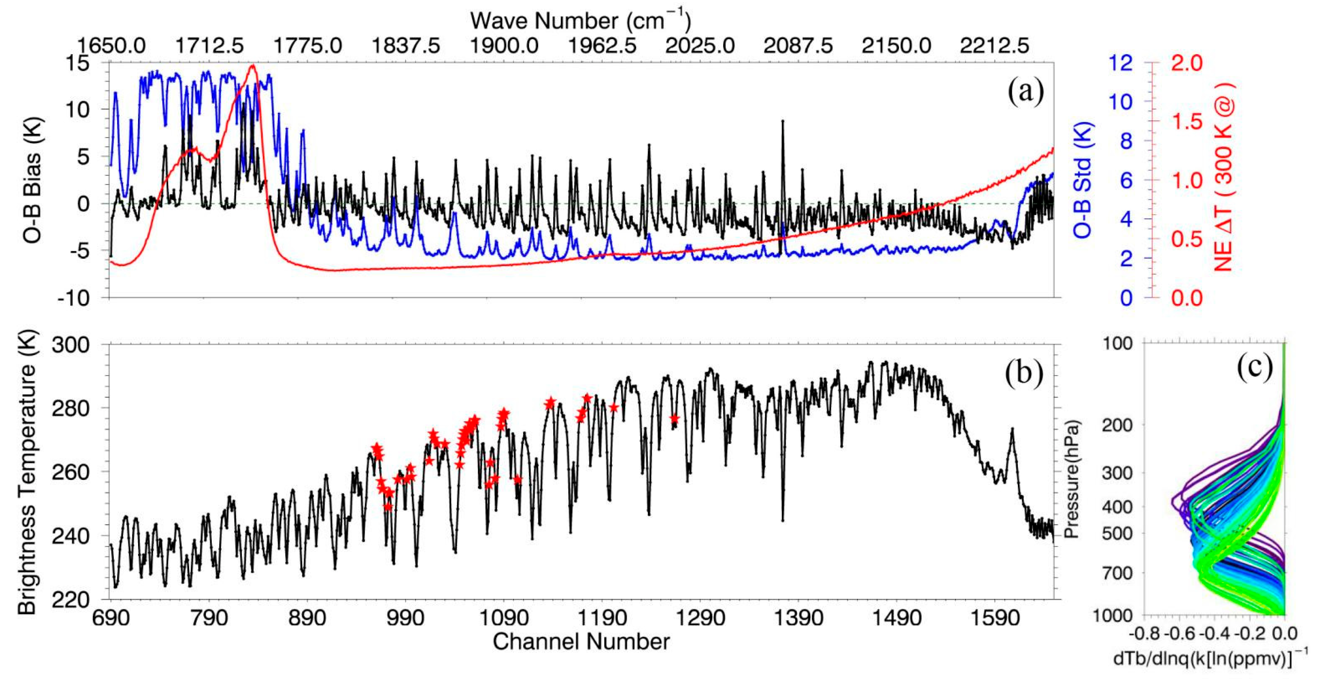
Figure 1. (a) Bias characteristics and (b) brightness temperature of GIIRS MWIR channels, and (c) the humidity Jacobians of selected channels.
Remotesensing 14 05710 g001
Figure 2. (a) The 24-h accumulated precipitation observed on 20 July 2021 and (b) hourly precipitation observations for Zhengzhou station and the whole of Henan Province.
Remotesensing 14 05710 g002
Figure 3. Radar composite reflectivity (dBZ) observed on 20 July 2021. The black triangle indicates the location of Zhengzhou national meteorological station. (ad) correspond to 0000 UTC, 0900 UTC, 1200 UTC, and 2400 UTC on 20 July, respectively, and the Zhengzhou station is marked with a black triangle.
Remotesensing 14 05710 g003
Figure 4. Specific humidity increments (g g−1) between the CTRL and GIIRS single channel 967 (1823.125 cm−1) assimilation experiment at 400 hPa, at 0000 UTC on 19 July 2021. Colored dots represent the O-B (K) after bias correction and quality control of channel 967.
Remotesensing 14 05710 g004
Figure 5. Regional distributions of the differences between observations and simulations (O-B, K) after BC and QC of (a) channel 1046 and (b) channel 1202. The white-grey-black shadow represents the distribution of clouds that were observed by the AGRI IR window channel (10.8 μm) at 0000 UTC on 19 July 2021. (c) Specific humidity differences (shaded, kg kg−1) between the CTRL and GIIRS experiments (49 WV channels assimilated), and the wind field (black barb) of the GIIRS at 500 hPa. The data used are from the analysis at 0000 UTC on 19 July 2021.
Remotesensing 14 05710 g005
Figure 6. (a) Geopotential height (gpm) at 500 hPa in the CTRL experiment (blue contour) and the differences between the GIIRS and CTRL experiments (shaded), the (b) wind directions of the GIIRS (blue barbs) and CTRL (black barbs) experiments at 850 hPa, and the wind speed (m s−1) differences between the GIIRS and CTRL experiments (shaded) at 850 hPa at 0000 UTC on 20 July 2021.
Remotesensing 14 05710 g006
Figure 7. Vertical cross sections of water vapor flux (kg m−1 s−1) of the CTRL experiment (a), the GIIRS experiment (b), and their differences (c) along 34.71°N at 0000 UTC on 20 July 2021 (24-h forecast initialized from 0000 UTC on 19 July 2021). (df) are the same as (ac), but for 0800 UTC on 20 July 2021 (32-h forecast initialized from 0000 UTC on 19 July 2021). The black arrow indicates Zhengzhou Station (113.66°E, 34.71°N).
Remotesensing 14 05710 g007
Figure 8. Vertical cross sections of w wind (m s−1) of the CTRL experiment along 34.71°N at 0000 UTC (a), 0800 UTC (b), and 1200 UTC (c), on 20 July 2021 (24-h, 32-h and 36-h forecasts initialized from 0000 UTC on 19 July 2021). (df) are the same as (ac), but for the GIIRS experiment. The black arrow indicates Zhengzhou Station (113.66°E, 34.71°N).
Remotesensing 14 05710 g008
Figure 9. Radar composite reflectivity (dBZ) of the CTRL experiment at 0000 UTC (a), 0900 UTC (b), and 1200 UTC (c) on 20 July 2021 (24-h, 33-h and 36-hourour forecasts initialized from 0000 UTC on 19 July 2021). (df) are the same as (ac), but for the GIIRS experiment. The black triangle indicates Zhengzhou Station (113.66°E, 34.71°N).
Remotesensing 14 05710 g009
Figure 10. The predicted 24-h accumulated precipitation from 0000 UTC on 20 July 2021 to 0000 UTC on 21 July 2021 (shading; mm) by the CTRL (a) and GIIRS (b) experiments from the cold-start at 0000 UTC on 19 July 2021. (c,d) are the same as (a,b), but for the warm-start at 0600 UTC on 19 July 2021. The black dot represents the center of maximum precipitation.
Remotesensing 14 05710 g010
Publisher’s Note: MDPI stays neutral with regard to jurisdictional claims in published maps and institutional affiliations.