Article

Combined Effects of the ENSO and the QBO on the Ozone Valley over the Tibetan Plateau

1
College of Ocean and Meteorology, South China Sea Institute of Marine Meteorology, Key Laboratory of Climate, Resources and Environment in Continental Shelf Sea and Deep Sea of Department of Education of Guangdong Province, Laboratory for Coastal Ocean Variation and Disaster Prediction, Guangdong Ocean University, Zhanjiang 524088, China
2
Key Laboratory of Space Ocean Remote Sensing and Application, Ministry of Natural Resources, Beijing 100081, China
3
Key Laboratory of Meteorological Disaster, Ministry of Education (KLME), Joint International Research Laboratory of Climate and Environment Change (ILCEC), Collaborative Innovation Center on Forecast and Evaluation of Meteorological Disasters, Nanjing University of Information Science and Technology, Nanjing 210044, China
4
Reading Academy, Nanjing University of Information Science and Technology, Nanjing 210044, China
*
Author to whom correspondence should be addressed.
Remote Sens. 2022, 14(19), 4935; https://doi.org/10.3390/rs14194935
Submission received: 6 September 2022 / Revised: 28 September 2022 / Accepted: 28 September 2022 / Published: 2 October 2022

Abstract

:
The El Niño–Southern Oscillation (ENSO) and the quasi-biennial oscillation (QBO) are two major interannual variations observed in the tropics, yet the joint modulation of the ENSO and QBO on the ozone valley over the Tibetan Plateau (TP) in summer has not been performed. This study investigates the combined effects of the ENSO and the QBO on the interannual variations of the ozone valley over the TP using the ERA5 reanalysis data from 1979 to 2021. The results show that the ENSO leads the zonal deviation of the total column ozone (TCO*) over the TP by about 6 months. This means the TCO* in the summer of the following year is affected by the ENSO in the current year. This is consistent with the theory of recharge oscillation. In terms of dynamic conditions, the anomalous circulation resulting from the combined effect of El Niño and the easterly phase of the QBO (EQBO) lead to strengthened and upward anomalies of the South Asian high (SAH) over the TP, followed by reduced ozone valley with more negative anomalies over the TP in summer. As to thermodynamic conditions, affected by both El Niño and the EQBO, the atmospheric stability shows positive anomalies from the lower troposphere to the upper troposphere, and the positive anomaly areas are larger than those in other conditions. These findings indicate an unstable atmosphere, where convection is more likely to cause ozone exchange. The turbulent mixing of ozone at low levels and high levels leads to the ozone valley over the TP, with more negative anomalies in the upper troposphere and lower stratosphere (UTLS).

1. Introduction

Ozone in the upper troposphere and lower stratosphere (UTLS) changes the thermal structure and components of the atmosphere, resulting in important impacts on weather and climate [1,2]. Ozone depletion not only exposes living things to harmful ultraviolet radiation but also modulates the Earth’s radiative heating budget through chemical–radiative–dynamic processes. Ozone depletion exists not only in the Antarctic stratosphere [3,4,5] but also in the Arctic ozone layer [6]. In 2020, Nature reported that the largest ozone hole in history had appeared over the Arctic. Research on ozone depletion has been a hot spot for a long period. With the development of sounding technology [7,8,9,10], many studies have confirmed an “ozone valley” in the boreal summer over the South Asian high (SAH) and its adjacent areas, including the Tibetan Plateau (TP), with different observational data [11,12,13]. The ozone valley shows a double-core structure over the TP. According to previous studies, there are both physical and chemical factors contributing to the formation of the ozone valley and atmospheric dynamics are considered to play a major role [13,14,15]. In 2021, Chang et al. used different sets of satellite and reanalysis data to study the formation of the ozone valley from the perspective of climatic states. The results show that the leading factor affecting the structure of the ozone valley in summer is the anomalous distribution of the SAH caused by the sea surface temperature (SST) anomaly associated with the El Niño–Southern Oscillation (ENSO) [13], but research on the physical process of the influence of the ENSO in the ozone valley over the TP has not been carried out. In this study, we focused on multiple factors rather than a single factor in the formation mechanism of the ozone valley over the TP and provide further research with a basis for the formation of the ozone.
The ENSO and the quasi-biennial oscillation (QBO) are two major interannual variations in the tropics. The ENSO is often closely associated with El Niño of the warm sea anomaly and La Niña with the cold anomaly in the tropical Pacific Ocean over a period of 2–8 years. The QBO is the reversal between easterly and westerly winds of the equatorial zonal wind from 10 hPa to 100 hPa, with an interval of about 28 months [16].
The ENSO can affect stratospheric circulation by regulating the propagation and dissipation of stratospheric ultralong Rossby waves [17,18]. Regarding the changes in stratospheric ozone in the northern hemisphere, studies have shown that the ENSO is one of the main factors controlling the interannual variability of stratospheric ozone [19,20]. During El Niño events, the total column ozone (TCO) increases in the Arctic and mid-latitudes [21], whereas the changes in polar stratospheric ozone are the opposite during La Niña events [22]. What is more, there is a lagging effect in the climate effects of the ENSO [23,24]. From the statistical point of view, the SST anomalies in the tropical Indian Ocean lag about 6 months behind those in the equatorial eastern Pacific Ocean. The peak of El Niño occurs around the end of the year [25,26]. The processes are consistent with the mechanism derived from the paradigm of the current theory of recharge oscillation and/or delayed oscillation theory [27]. Via a Matsuno–Gill-type circulation response, when the SST anomaly occurs in the Indian Ocean and the equatorial Pacific, the anticyclonic circulation anomaly is generated in the western Pacific and the South China Sea, which affects the variation of the western Pacific subtropical high in summer [28]. Will this lagging effect affect the double-core structure of the ozone valley over the TP in summer? This is the first question to be answered in this study.
An important dynamic process in the tropical stratosphere, the quasi-biennial oscillation (QBO) is also the main factor affecting stratospheric ozone [29]. The meridional circulation caused by the QBO can drive TCO to appear as a quasi-biennial oscillation signal [30]. The easterly phase of the QBO (EQBO) induces upwelling in the lower tropical stratosphere and results in negative anomalies of TCO in the equator, while for the westerly phase of the QBO (WQBO), the circulation reverses, resulting in positive anomalies of TCO [31,32]. What is more, the seasonal variations of wind QBO causes the seasonal dependence of the ozone QBO in the equatorial region [33]. The ozone QBO lags behind the tropical wind QBO for about 1 to 3 months over the TP [34].
However, most research has focused on a certain factor in the formation mechanism of the ozone valley over the TP and there is a lack of comprehensive study on the formation mechanism of the double-core structure of the ozone valley. Multiple factors need to be integrated to better understand the formation mechanism. In recent years, studies have shown that the combined modulation of the QBO and ENSO will affect the Madden–Julian Oscillation (MJO) and Northern Hemisphere ozone in winter [35]. The second type of ENSO (the ENSO Modoki) is anomalous warming different from conventional El Niño events that occur in the central equatorial Pacific, which involves a unique tripolar sea level pressure pattern. Since Modoki events precede tropical ozone changes, it is possible they can serve as a predictor of tropical TCO variations [36]. During the EQBO phase, stratospheric ozone anomalies in the Northern Hemisphere are amplified during El Niño Modoki events but reduced during La Niña Modoki events. The response of ozone in the tropics to the ENSO together with the QBO has been investigated in previous studies [36,37]. However, few studies have been performed on the effect of the ENSO over the TP ozone in summer. In particular, the joint modulation of the two important interannual variability signals, the ENSO and QBO, on the ozone valley over the TP in summer has not been carried out yet. Therefore, this study focused on the ozone valley over the TP in summer and the joint impact of the ENSO and QBO on the ozone valley. Through this study, we can further understand the formation mechanism of the ozone valley over the TP in summer and provide a basis for the formation of the ozone valley.
The remainder of this paper is organized as follows. Section 2 briefly describes the data analysis and methodology. Section 3 explores the combined effects of the ENSO and QBO on the ozone valley over the TP. Section 4 investigates the possible impact mechanism of the QBO and ENSO on the ozone valley by composite analysis. Discussion and conclusions are presented in Section 5.

2. Data and Methods

2.1. Data

Compared with data on the ozone valley using different datasets, such as the European Center for Medium-Range Weather Forecasts Interim Reanalysis (ERA5), Modern-Era Retrospective Analysis for Research and Applications dataset version 2 (MERRA2) monthly data with a spatial resolution of 0.5° × 0.625°, and the Stratospheric Water and Ozone Satellite Homogenized observation dataset (SWOOSH) monthly data with a spatial resolution of 20° × 5°, the use of tree datasets to calculate the ozone valley yields similar results within the same magnitude [13]. Because ERA5 reanalysis data show high temporal and spatial resolution, ERA5 monthly reanalysis data on ozone mixing ratio, sea surface temperature (SST), temperature, atmospheric wind field, and geopotential height from 1979 to 2021 with a spatial resolution of 0.25° × 0.25° were used in this study (https://www.ecmwf.int/en/forecasts/datasets/reanalysis-datasets/era5, accessed on 10 September 2022). The heights of thermal tropopause and dynamical tropopause were obtained from MERRA2.
According to the classification method proposed by Yuan (2020) [38], an El Niño event is identified if the 5-month running average of the Niño 3.4 index exceeds 0.5 for 5 months or more. According to this method, if the index greater than 0.5 is interrupted for 2 months or more, the two events are considered to be discontinuous. If the interruption is 1 month and the 3-month running average of the Niño 3.4 index for that month exceeds 0.5, the events before and after that month are considered one continuous event. Otherwise, they are separate events. Similarly, the La Niña event is defined by the 5-month running average of Niño 3.4 index less than −0.5. The Nino 3.4 index data used in this study were from the monthly SST anomalies (SSTA) made available by the Climate Prediction Center (CPC) (https://psl.noaa.gov/data/climateindices/list, accessed on 10 September 2022) for the period 1979 to 2021.
Several methods have been proposed in previous studies to identify the phases of the QBO. According to the classification method proposed by Ribera et al. (2004), the QBO index was set to be 30 hPa mean zonal wind in the equatorial region (5°S−5°N), and the westerly (easterly) phases of QBO were defined as greater (less) than 5 (−5) m/s [39]. The QBO index was provided by NOAA Physical Sciences Laboratory (PSL) (https://psl.noaa.gov/data/climateindices/list, accessed on 10 September 2022).

2.2. Methodology

As per the method proposed by Bian (2011) [40], we calculated the zonal deviation of the total column ozone (TCO*), which is defined as TCO   =   O     O ¯ , where O is the ozone mass mixing ratio and is the zonal average of O. More detailed information can be found in Chang (2021) [13]. The ozone valley shows two prominent negative centers over the SAH and its adjacent areas.
Composite analysis was adopted and the t-test was used to evaluate statistical significance in this study. The anomalies mentioned in this paper refer to the difference between variables under different climatic backgrounds and those under averaged climatic backgrounds in summer for 40 years.
Lead–lag correlation, t-tests, and composite analysis are used in this study. First of all, the leading relationship between the ENSO and the ozone valley over the TP and between the QBO and the ozone valley were obtained based on lead–lag correlation. According to the area range where the double-core structure of the ozone valley appears at its maximum [13], the TCO* variation index (TCOI) is defined as the standardized average TCO* in the region from 35°E to 110°E and from 20°N to 45°N. Then, the time series of the Niño 3.4 index and QBO index were separately used to obtain their lead–lag correlations with the TCOI. The lagged correlation coefficient statistically describes the correlation between two variables at different times. The lagged correlation coefficient with lag length j is defined as r x y ( j ) . Correlation coefficients with different lag lengths can help us to understand relationships between a variable at one time and another variable at a later time. For variables x and y, the correlation coefficient with lag length j is r x y ( j ) = 1 n j i = 1 n j ( x i x ¯ S x ) ( y i + j y ¯ S y ) , where r x y ( j ) is the lagged correlation coefficient, n is the original length of the dataset, j is the lag length, and x ¯ , y ¯ , S x , and S y are the average and standard deviation of the variables x and y, respectively. When j = 0, this represents the simple correlation of two variables. Whether the lagged correlation coefficient is significant requires a significance test. We perform t-tests to determine the significance of r x y . The results are shown in Figure 1.
The ENSO leads the TCO* by about 6 months with a correlation of 0.2 (yellow line). Although the correlation coefficient is below 0.25, the positive correlation is statistically significant. According to the theory of recharge oscillation and delayed oscillation theory, the peak of El Niño occurs around winter (December–February). The SST anomalies in the tropical Indian Ocean lag about 6 months behind those in the equatorial eastern Pacific Ocean. The TCO* lags about 6 months behind the ENSO, suggesting that the TCO* in the summer of the following year is affected by the ENSO of the current year. This is consistent with theory of recharge oscillation. The correlation coefficient was largest at lag 0. However, as the ozone valley does not usually appear in winter and the composite results of ozone in the same period show little difference, we only took 6 months into consideration.
The correlation with the QBO leading that with the TCO* by about 6–9 months is statistically significant (blue line). The EQBO induces upwelling in the lower tropical stratosphere and results in negative anomalies in TCO*, while the lead time of the QBO is almost the same as that of the ENSO. Will this circulation anomaly lead TCO* and can the two factors produce a resonance effect through a certain response? To answer these questions, we further analyze the corresponding results in the following sections.
To obtain the atmospheric convection conditions, we present the atmospheric stability from the perspective of thermal conditions. Atmospheric stability can usually be determined by atmospheric temperature differences [41]. Since the troposphere is the inversion layer, the temperature difference between the upper layer and the lower layer can determine whether the atmosphere is stable. If the result of the upper-layer temperature minus the lower-layer temperature is positive, the atmosphere in this layer is not temperature-inversed and therefore unstable. On the contrary, negative results suggest a stable atmosphere. In this study, we chose the temperature at 700 hPa near the lower troposphere, 500 hPa near the middle troposphere, 300 hPa near the upper troposphere and 200 hPa near the tropopause to calculate the atmospheric temperature differences. The temperature at 500 hPa minus that at 700 hPa was chosen to represent the atmospheric stability in the lower troposphere, because the temperatures in both levels include the whole lower troposphere, and if we chose the temperature at 850 hPa as the lower troposphere, similar results could have been obtained. Using the same method, the temperature at 200 hPa minus that at 500 hPa represents the atmospheric stability in the middle troposphere, and the temperature at 200 hPa minus that at 300 hPa represents the atmospheric stability in the upper troposphere.

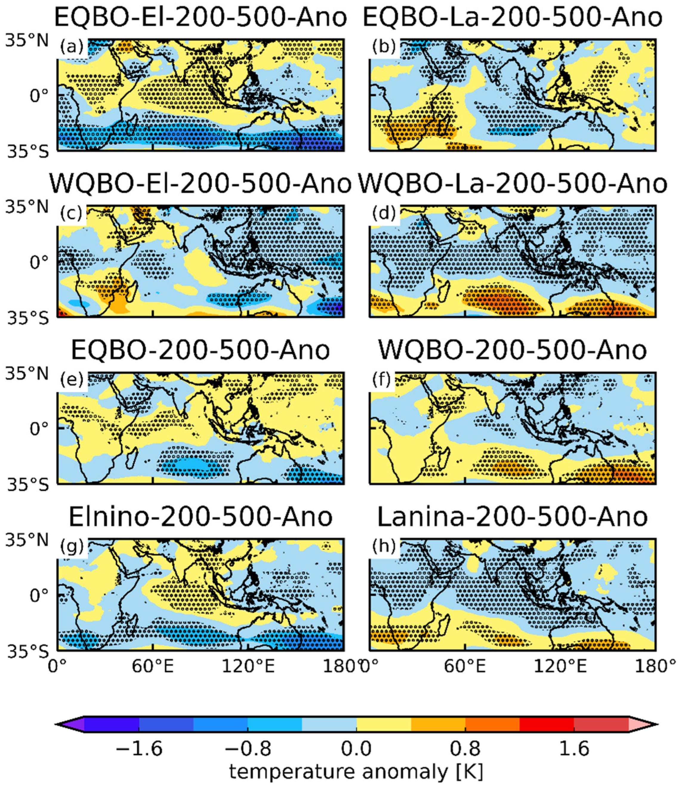
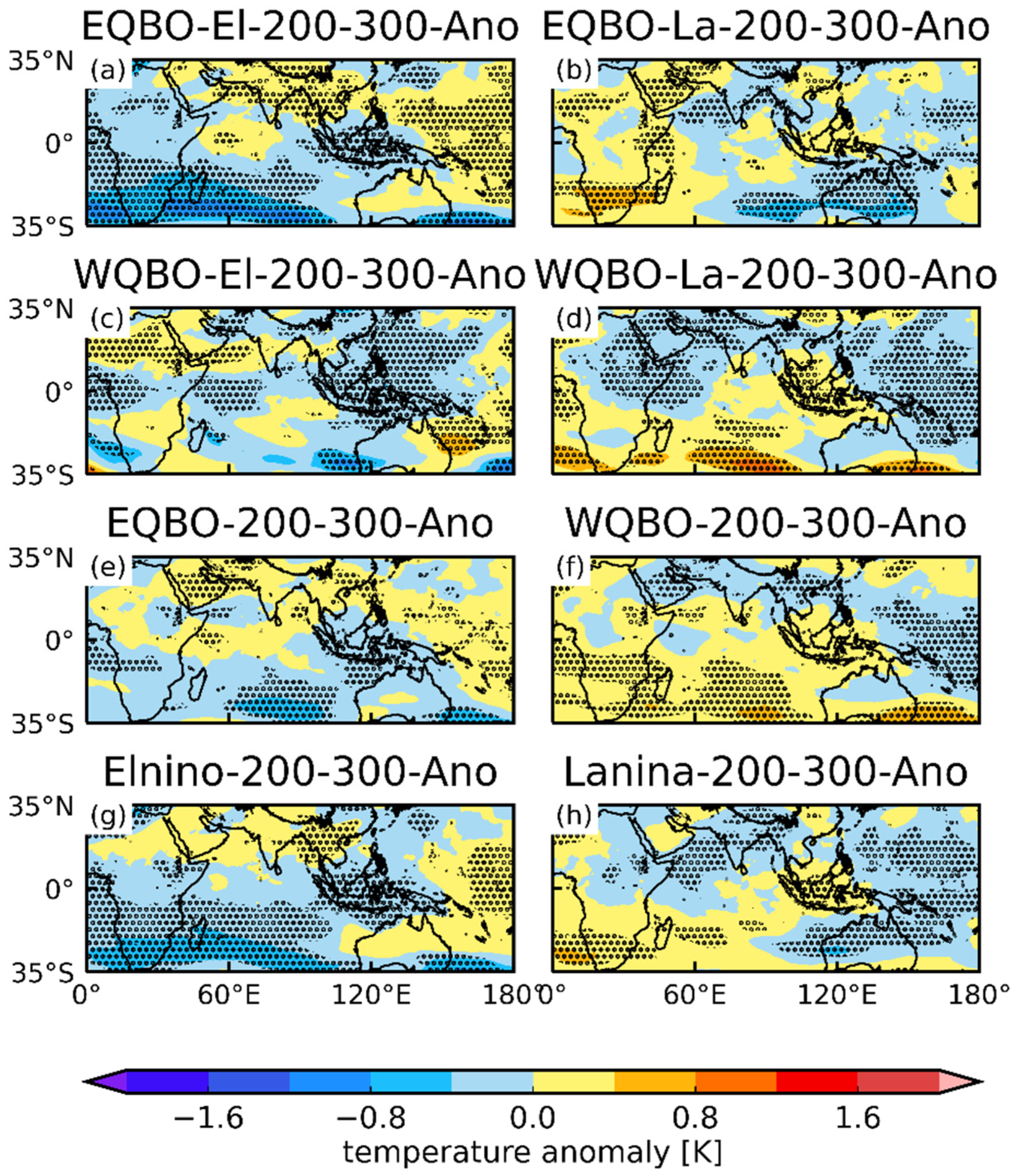
3. Combined Effects of the ENSO and QBO on the Ozone Valley over the TP

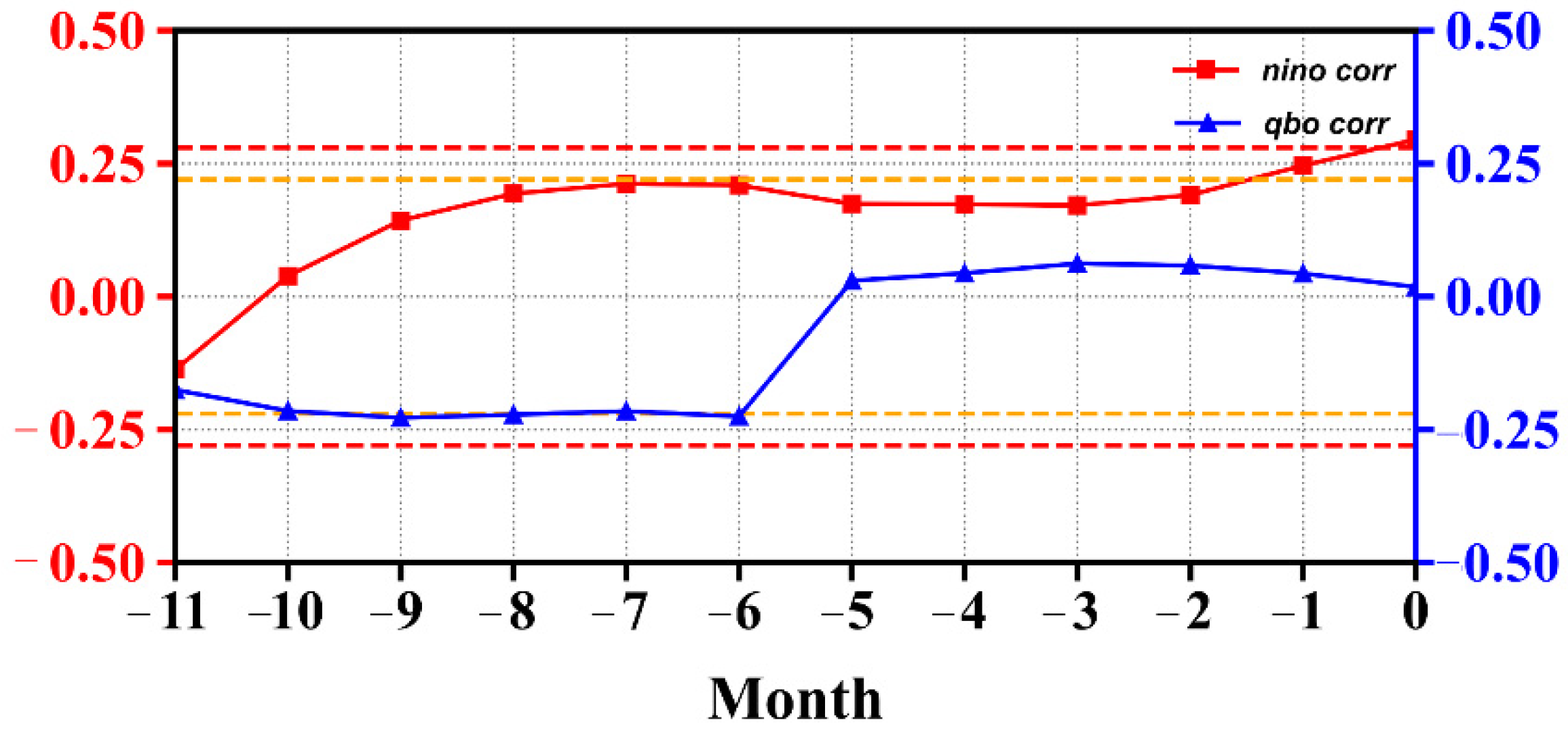
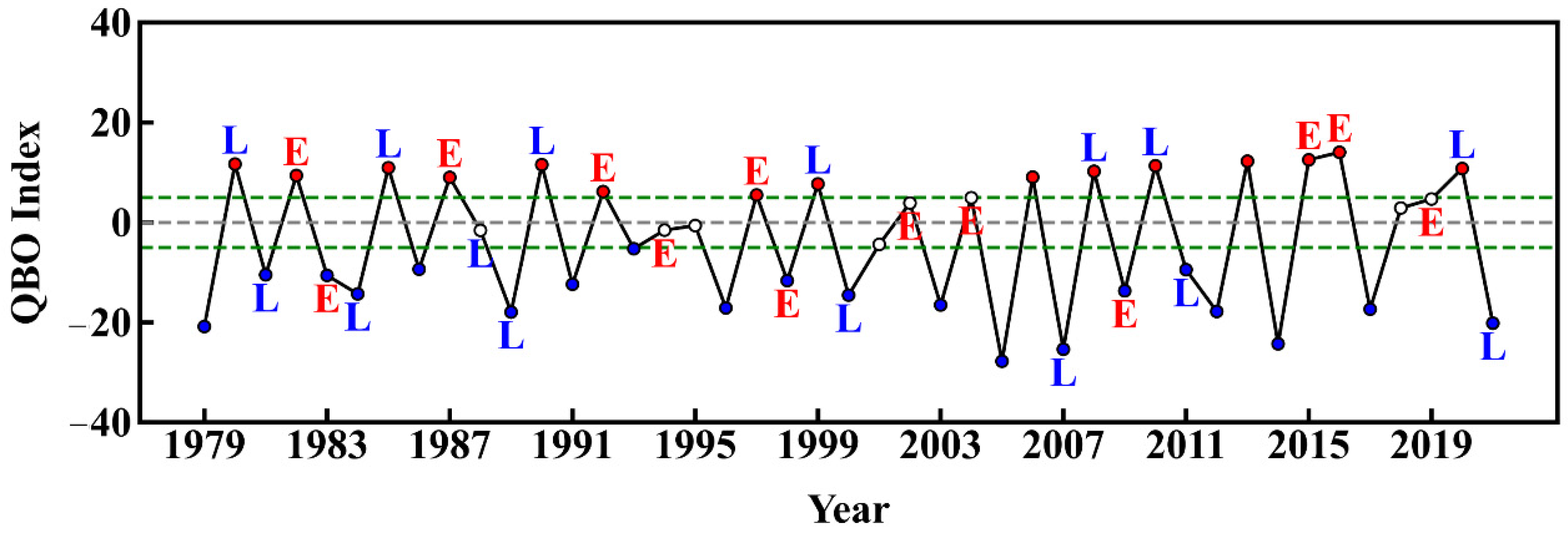
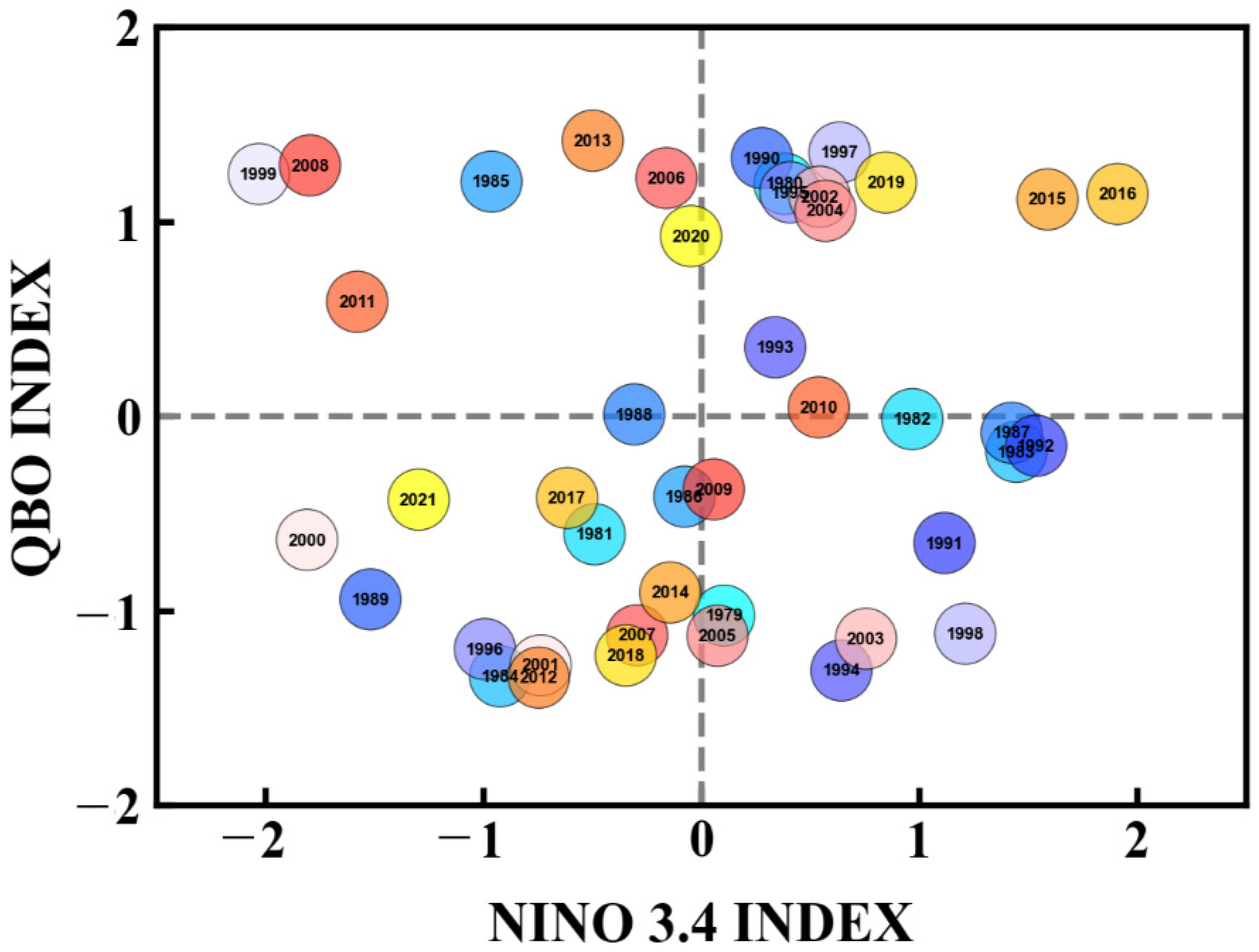
3.1. Division of the ENSO and QBO

Based on the definition of El Niño and La Niña events in Section 2, those that occurred from 1979 to 2021 were obtained. The correlation with the QBO leads that with the TCO* by about 8 months, which means TCO* in June, July, and August is affected by the QBO in the previous October, November, and December. Therefore, the averaged QBO index in October, November and December was used and the results are shown in Figure 2. The WQBO years and EQBO years are represented by red and blue circles, respectively. The white circles are neutral QBO years, which were not considered in this study. “E” denotes El Niño years and “L” stands for La Niña year.
Accordingly, thirteen El Niño years and fifteen La Niña years were identified from 1979 to 2021. The statistical results are shown in Table 1. According to the lead–lag correlation results obtained in Section 2, the years that affect the following summer ozone valley are called the impact years in this paper, as shown in Table 2.
To verify whether the selected ENSO positive- and negative-phase years are independent of the EQBO and WQBO years, a sample scatter distribution of the QBO index averaged in October, November and December and the Niño 3.4 index averaged in December, January and February of the following years was constructed (Figure 3). It can be seen that the samples present a nonuniformly dispersed distribution. The correlation coefficient between the two factors is only 0.12, so not significant. Therefore, the two factors are independent, and composite analysis can be used in further classification studies.

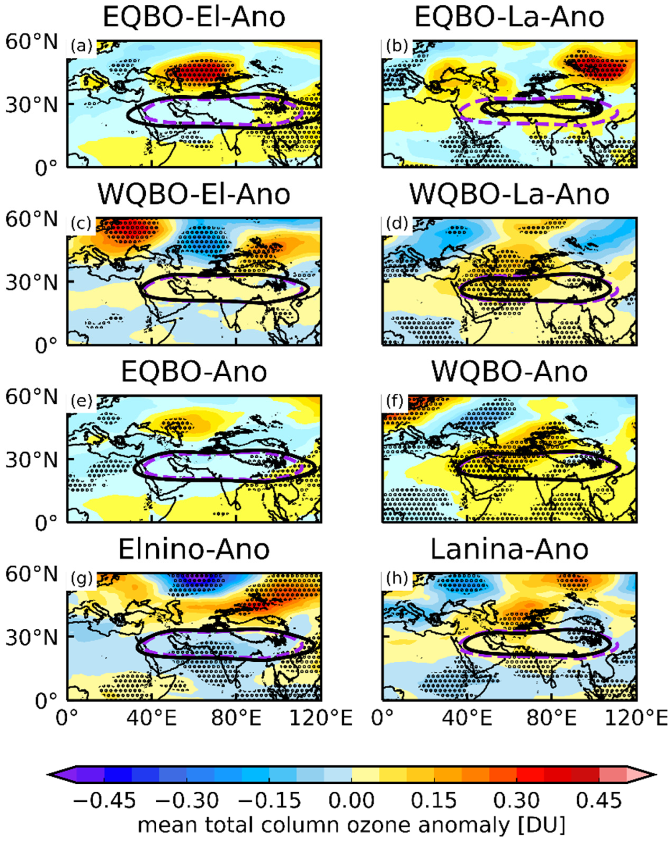
3.2. Responses of the Ozone Valley over the TP in the following Summer to the ENSO and QBO

The responses of the ozone valley over the TP in the following summer to the ENSO and QBO were studied based on a composite analysis with the years in Table 2. To test whether the mean values of a certain variable were significantly different during different the ENSO/QBO phases, two-tailed t-tests were performed. The results helped us to further explore whether the two factors can produce a resonance effect through a certain response. In this study, TCO* lagging behind the QBO by 8 months was selected (Figure 4), because in other months, TCO* response is not obvious (figures omitted). We took TCO* lagging behind the QBO by 9 months as an example (Figure 5), because the TCO* lagging behind the QBO by 9 months in Figure 1 was also statistically significant.
Figure 4 presents the TCO* anomalies (shaded) and the location of the SAH (12,520 gpm). The 12,520 gpm geopotential height isolines can determine the SAH area [42]. For comparison, the climatological location of the SAH region is given. The strengthening of the SAH moves air from the troposphere to the lower stratosphere. It causes negative TCO* anomalies over the TP in an extra period. It should be noted that the effect of the ENSO and QBO on the ozone valley was significant and the composite analysis years are shown in Table 2.
The TCO* anomalies over the TP in the following summer were negative for both the EQBO (Figure 4e) and El Niño (Figure 4g), and positive TCO* anomaly regions were larger than negative WQBO regions (Figure 4f) and La Niña (Figure 4h). Negative TCO* anomaly regions for EE (Figure 4a) were larger than those for EL (Figure 4b), WE (Figure 4c), WL (Figure 4d), EQBO (Figure 4e), WQBO (Figure 4f), El Niño (Figure 4g), and La Niña (Figure 4h). Thus, under the combined effect of EE, the ozone valley over the TP in summer showed more negative anomalies.
Focusing on the differences in the SAH (12,520 gpm), the area of the SAH is different under different conditions. Under the EE (Figure 4a), with the TCO* anomaly regions being the largest, the SAH area is larger than those under other conditions and the climatological location. The east–west boundary can reach 30°E–120°E. The strengthening of the SAH moves air from the troposphere with lower ozone content to the stratosphere, enhancing the negative TCO* anomalies over the TP, which is consistent with the previous results [1]. Compared with the climatological location of the SAH region, the SAH area is smaller except under the EE (Figure 4b–h). The SAH area is the smallest under the WL and the climatological location. Although the TCO* anomaly regions were positive, they were not significant (two-tailed t-test).
Figure 5 presents the TCO* anomalies lagging behind the QBO by 9 months. Although the negative TCO* anomaly regions for EE (Figure 5a) are larger than those for other conditions, this difference was not significant (two-tailed t-test), especially over the SAH area. Compared with the results in Figure 4, it shows fewer differences.

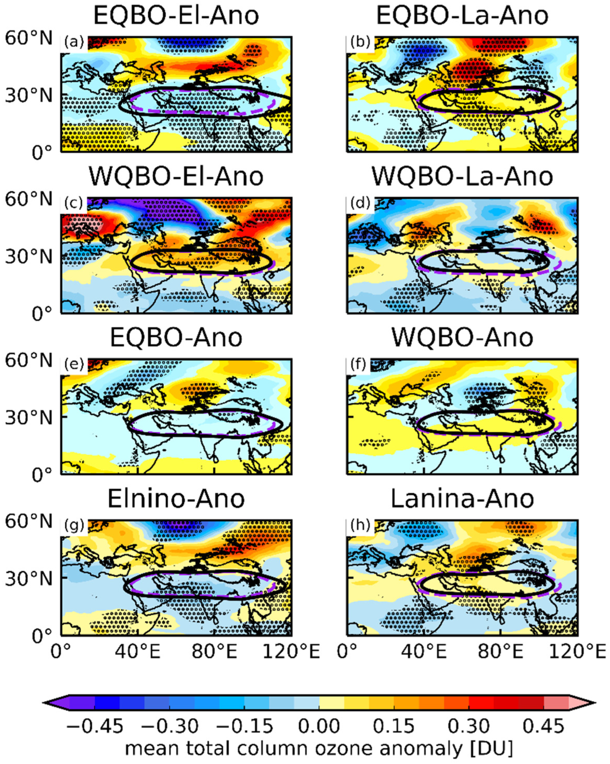
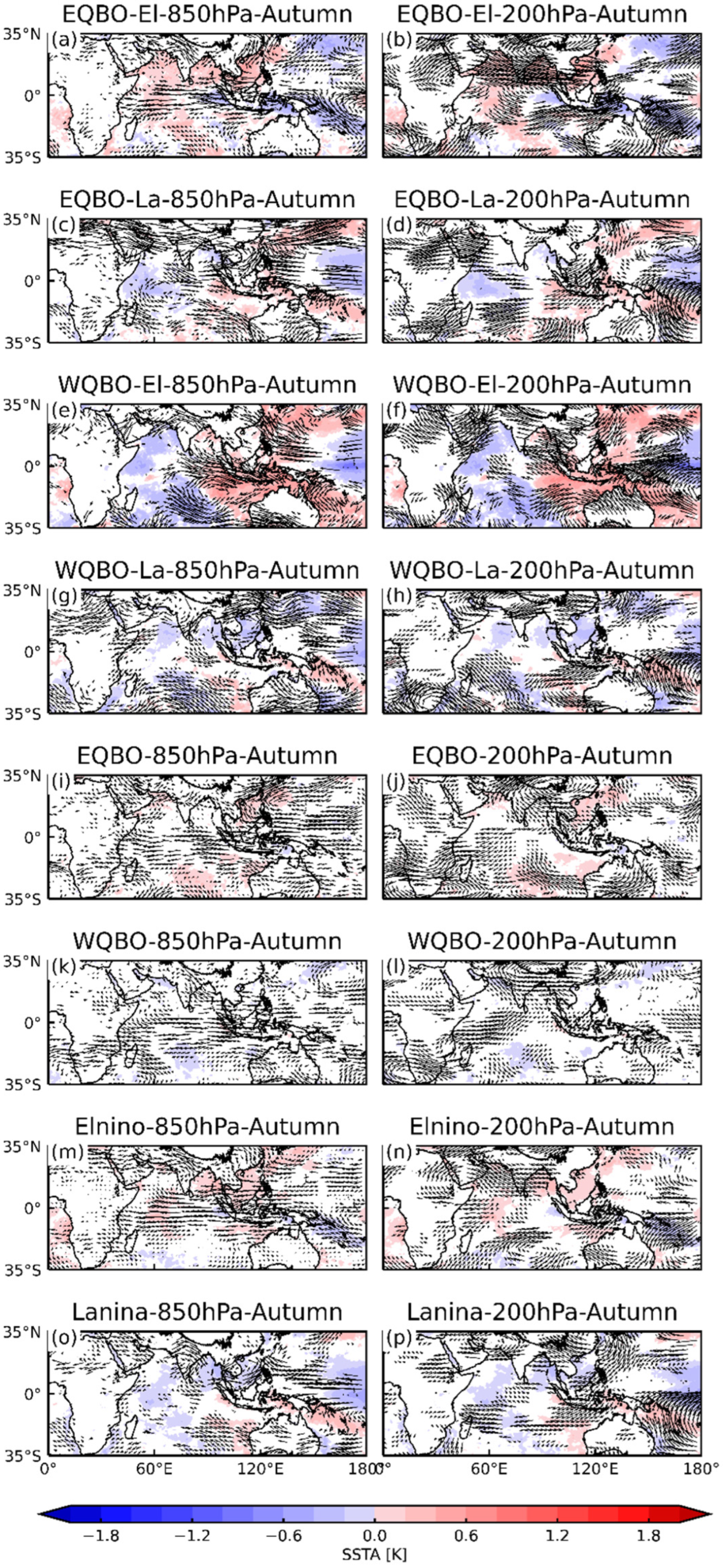
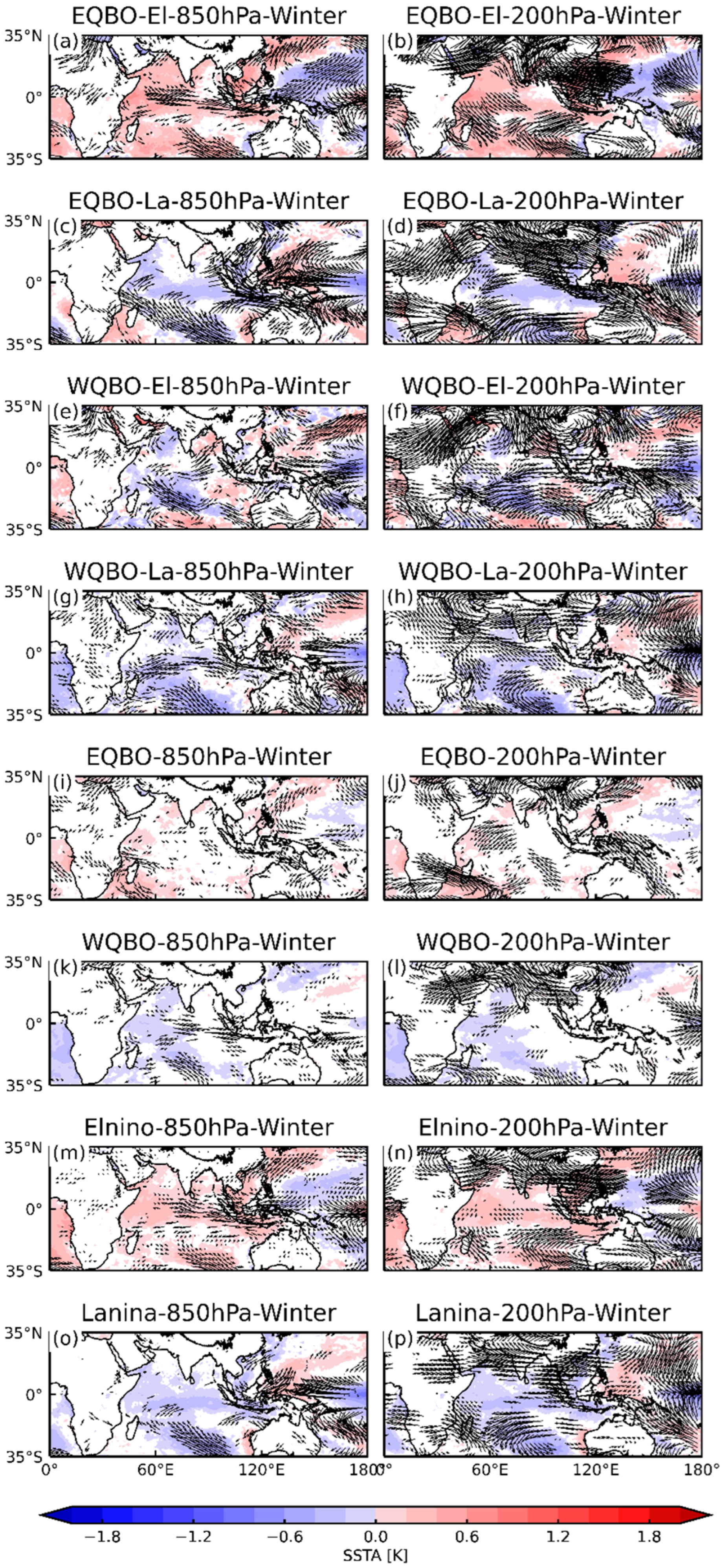
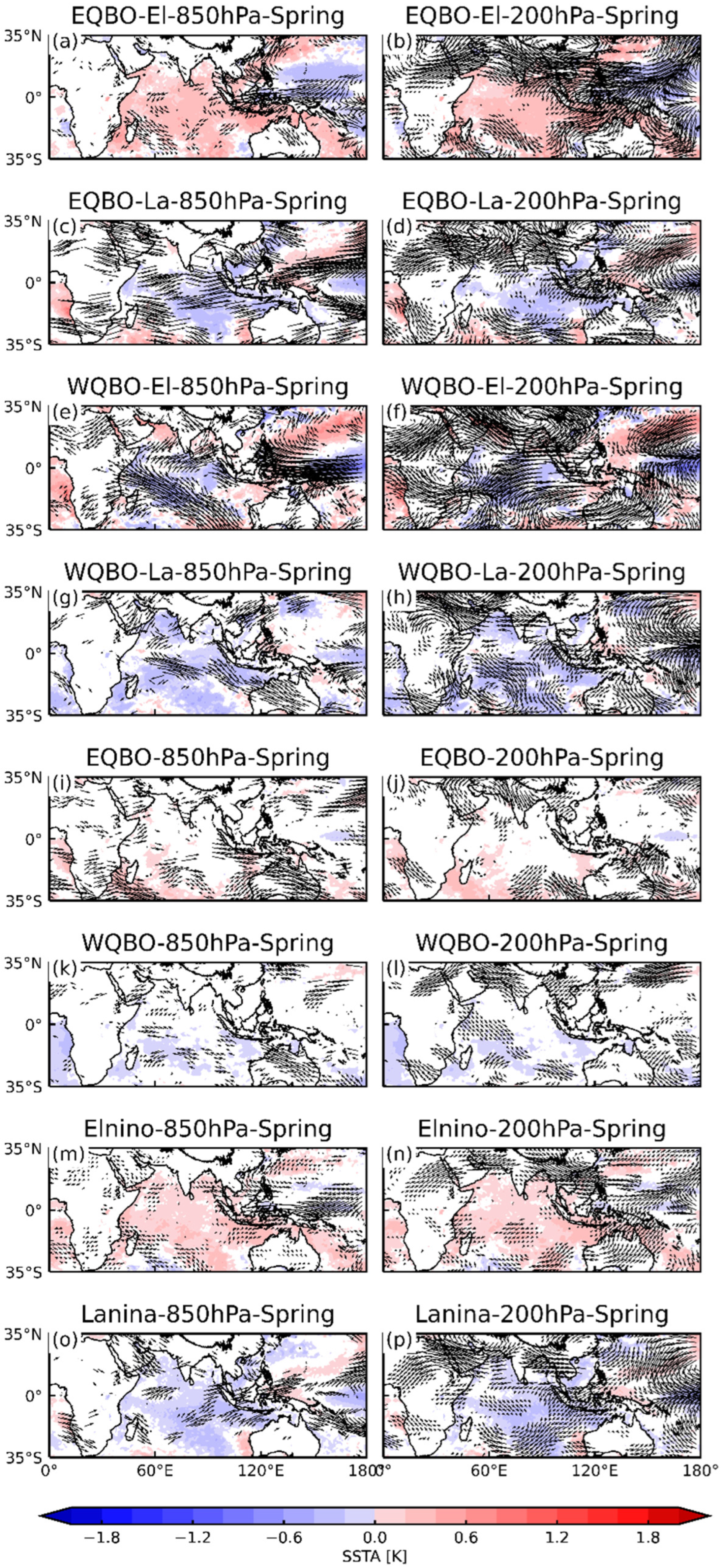
4. Mechanistic Analysis

4.1. Dynamic Reasons

How does the combined EE affect the SAH and then affect the ozone valley over the TP in summer? For dynamic reasons, we present the composite wind anomalies at 850 hPa and 200 hPa and SSTA under different conditions from autumn and winter of the ENSO-developing years (Figure 6 and Figure 7) to spring and summer of the ENSO-decay years (following years) (Figure 8 and Figure 9). Here, we only present the results that exceeded the 95% confidence level (t-test).
In the autumn of the ENSO-developing years, under the EE, anticyclones at 850 hPa were weaker and eastward in the western Pacific Ocean. There was a cyclone at 200 hPa near the TP (Figure 6). Compared with under the ENSO and QBO, the circulation under the EE was stronger. Subsequently, the peak of El Niño occurred in winter (December–February). In winter, the TP was a cold source, and the SAH was not formed. It showed a cyclone anomaly at 200 hPa (Figure 7). In the following spring, the ENSO was in a decay phase and the circulation gradually changed into an anticyclonic anomaly (Figure 8).
In the following summer (Figure 9), the ENSO was still in a decay stage, but due to the capacitor effect, anticyclones at 850 hPa in the western Pacific were stronger and westward. Correspondingly, the SAH anticyclone over the TP at 200 hPa reaches its peak. Under the EE, on the one hand, the EQBO induced upwelling in the lower tropical stratosphere, which led to negative anomalies of ozone. On the other hand, because of the ENSO (Figure 9a), the SSTA in the western Pacific showed negative anomalies and the zonal SST gradient was weakened. The atmosphere can respond to this variation in ocean heat and a series of planetary waves can be simulated and travel westward. Cyclones at low latitudes strengthen the bypassing currents. This process is also known as a Matsuno–Gill-type response. At 200 hPa (Figure 9b), anticyclones over the south of the TP can be seen. Based on the wind fields at 850 hPa and 200 hPa over the southern TP, the strengthening of divergence at 200 hPa tended to move more air from the troposphere with lower ozone content to the stratosphere. Thus, the TCO* decreased under the EE.
We have analyzed the horizontal circulation above. The vertical circulations in the following summer are given in Figure 10. According to Chang (2021) [13], two prominent negative centers are near 50°E and 90°E, respectively. The height–latitude cross sections of the composite wind field and the ozone mixing ratios along 50°E and 90°E are presented in Figure 10 and Figure 11.
Figure 10 shows the composite wind field along 50°E. Under the EE (Figure 10a), from 20° N to 45° N, in the UTLS region, the ozone anomalies are negative. Combined with the composite wind anomalies (in Figure 9a), the strengthening of divergence at 200 hPa leads to divergence anomalies and upward anomalies. The wind field moves air across the tropopause from the troposphere to the lower stratosphere, causing the TCO* to decrease.
Similarly, Figure 11 shows the composite wind field along 90°E. Compared with other conditions, under the EE (Figure 11a), from 10°N to 40°N, in the UTLS region, the ozone anomalies are negative. The low ozone content in the troposphere causes the TCO* in the UTLS to decrease. The wind anomalies (Figure 11) show an upward trend from 0 to 15°N in the low latitudes, but a downward trend in the middle latitudes 20°N–60°N. Normally the ozone content is lower in the low latitudes than in the middle and high latitudes. The wind field moves air from low latitudes with lower content to the middle and high latitudes, causing the TCO* to decrease.
Previous analysis for circulation has revealed the dynamic conditions. The combined effect of El Niño and EQBO makes the circulation anomalous, resulting in a strengthened SAH and upward anomalies over the TP, followed by a reduced ozone valley over the TP in summer with more negative anomalies. The results that exceed the 95% confidence level (t-test) are indicated.

4.2. Thermodynamic Causes

To obtain the atmospheric convection conditions, we further present the atmospheric stability from the perspective of thermal conditions. When the atmosphere is unstable, thermal turbulence develops vigorously, the convection is strong, and the gas components are easily exchanged, and vice versa. The atmospheric temperature differences at different levels are shown in Figure 12, Figure 13 and Figure 14.
In Figure 12, Figure 13 and Figure 14, the atmospheric stability under EE is about 0.4 K from the lower troposphere to the upper troposphere. Compared with other conditions, the positive anomaly areas are larger. Therefore, the atmosphere is unstable. Under such atmospheric conditions, convection is more likely to occur and result in ozone exchange. The turbulent mixing of ozone at low level and high level leads to the ozone valley over the TP with more negative anomalies in the UTLS.

5. Conclusions

Using the ERA5 reanalysis dataset from 1979 to 2021, we examined the combined effects of the ENSO and the QBO on the ozone valley over the Tibetan Plateau and drew the following conclusions.
(1) The ENSO leads the TCO* over the TP by about 6 months. From the onset to the peak of El Niño, the peak occurs around the winter of the year (December–February). The TCO* lags about 6 months behind the ENSO, suggesting the TCO* in the summer of the following year is affected by the ENSO of the current year, which is consistent with the theory of recharge oscillation.
(2) In terms of dynamic conditions, the combined effect of El Niño and EQBO makes the circulation anomalous, resulting in a strengthened SAH and upward anomaly over the TP, followed by a reduced ozone valley over the TP in summer with more negative anomalies. Through composite analysis of the wind field and SST, under the combination of El Niño and the EQBO, the atmospheric circulation pattern is found to be consistent with a Matsuno–Gill-type response. The EQBO induces upwelling in the lower tropical stratosphere, which leads to negative anomalies of ozone. Comparing the high- and low-level wind fields over the southern TP, it is apparent that with the strengthening of the southern trough at 850 hPa and the strengthening of divergence at 200 hPa, the wind field moves air from the troposphere to the lower stratosphere.
(3) In terms of thermodynamic conditions, under the combination of El Niño and the EQBO, the atmospheric stability shows positive anomalies from the lower troposphere to the upper troposphere. Compared with other conditions, the positive anomaly areas are larger. Therefore, the atmosphere is unstable. Then, convection is more likely to occur and result in ozone exchange. The turbulent mixing of ozone at low and high levels leads to the ozone valley over the TP, with more negative anomalies in the UTLS.
Through this study, we can further understand the formation mechanism of the ozone and provide further research with a basis for the formation of the ozone.

Author Contributions

S.C., D.G. and C.S. provided the original suggestion for the work. S.C. and Y.L. produced the figures and wrote the initial draft. D.G. and S.C. reviewed and edited the manuscript. All authors have read and agreed to the published version of the manuscript.

Funding

This research was funded by the National Natural Science Foundation of China (42005063), Integration Project of the National Natural Science Foundation of China Major Research Program (91837311), Major Projects of the National Natural Science Foundation of China (42192512), Program for Scientific Research Start-Up Funds of Guangdong Ocean University (060302032107), Projects (Platforms) for Construction of Top-Ranking Disciplines of Guangdong Ocean University (231419022), Guangdong Provincial College Innovation Team Project (2019KCXTF021) and First-Class Discipline Plan of Guangdong Province (080503032101 and 231420003).

Data Availability Statement

The dataset from ERA5 for this study can be found at https://www.ecmwf.int/en/forecasts/datasets/reanalysis-datasets/era5, accessed on 10 September 2022. The Nino 3.4 index data used in this study can be found at https://psl.noaa.gov/data/climateindices/list, accessed on 10 September 2022. The QBO index can be found at https://psl.noaa.gov/data/climateindices/list, accessed on 10 September 2022.

Acknowledgments

The authors would like to thank the editors and the reviewers for their valuable suggestions.

Conflicts of Interest

The authors declare no conflict of interest.

References

  1. Bian, J.; Li, D.; Bai, Z.; Li, Q.; Lyu, D.; Zhou, X. Transport of Asian surface pollutants to the global stratosphere from the Tibetan Plateau region during the Asian summer monsoon. Natl. Sci. Rev. 2020, 7, 516–533. [Google Scholar] [CrossRef] [Green Version]
  2. Xia, Y.; Huang, Y.; Hu, Y. On the climate impacts of upper tropospheric and lower stratospheric ozone. J. Geophys. Res. Atmos. 2018, 123, 730–739. [Google Scholar] [CrossRef] [Green Version]
  3. Wang, Y.; Wang, H.; Wang, W. A Stratospheric intrusion-influenced ozone pollution episode associated with an intense horizontal-trough event. Atmosphere 2020, 11, 164. [Google Scholar] [CrossRef] [Green Version]
  4. Crutzen, P.J. The influence of nitrogen oxides on the atmospheric ozone content. Q. J. R. Meteorol. Soc. 1970, 96, 320–325. [Google Scholar] [CrossRef]
  5. Molina, M.J.; Rowland, F.S. Stratospheric sink for chlorofluoromethanes: Chlorine atom-catalysed destruction of ozone. Nature 1974, 249, 810–812. [Google Scholar] [CrossRef]
  6. Manney, G.L.; Santee, M.L.; Rex, M.; Livesey, N.J.; Pitts, M.C.; Veefkind, P.; Nash, E.R.; Wohltmann, I.; Lehmann, R.; Froidevaux, L. Unprecedented Arctic ozone loss in 2011. Nature 2011, 478, 469–475. [Google Scholar] [CrossRef]
  7. Zhang, X.; Zhou, J.; Göttsche, F.M.; Zhan, W.; Liu, S.; Cao, R. A method based on temporal component decomposition for estimating 1-km all-weather land surface temperature by merging satellite thermal infrared and passive microwave observations. IEEE Trans. Geosci. Remote Sens. 2019, 57, 4670–4691. [Google Scholar] [CrossRef]
  8. Zhang, J.; Sheng, Z.; Ma, Y.; He, Y.; Zuo, X.; He, M. Analysis of the positive Arctic oscillation index event and its influence in the winter and spring of 2019/2020. Front. Earth Sci. 2021, 8, 580601. [Google Scholar] [CrossRef]
  9. He, Y.; Zhu, X.; Sheng, Z.; Ge, W.; Zhao, X.; He, M. Atmospheric disturbance characteristics in the lower-middle stratosphere inferred from observations by the Round-Trip Intelligent Sounding System (RTISS) in China. Adv. Atmos. Sci. 2022, 39, 131–144. [Google Scholar] [CrossRef]
  10. Qin, Z.; Sheng, Z.; He, Y.; Feng, Y. Case Analysis of turbulence from high-resolution sounding data in Northwest China. Front. Environ. Sci. 2022, 10. [Google Scholar] [CrossRef]
  11. Xie, F.; Tian, W.; Chipperfield, M.P. Radiative effect of ozone change on stratosphere-troposphere exchange. J. Geophys. Res. Atmos. 2008, 113, D00B09. [Google Scholar] [CrossRef] [Green Version]
  12. Guo, D.; Su, Y.; Shi, C.; Xu, J.; Powell, A.M. Double core of ozone valley over the Tibetan Plateau and its possible mechanisms. J. Atmos. Sol.-Terr. Phys. 2015, 130, 127–131. [Google Scholar] [CrossRef]
  13. Chang, S.; Shi, C.; Guo, D.; Xu, J. Attribution of the principal components of the summertime ozone valley in the upper troposphere and lower stratosphere. Front. Earth Sci. 2021, 8, 721. [Google Scholar] [CrossRef]
  14. Ren, R.; Hu, J. An emerging precursor signal in the stratosphere in recent decades for the Indian summer monsoon onset. Geophys. Res. Lett. 2014, 41, 7391–7396. [Google Scholar] [CrossRef]
  15. Zhang, J.; Tian, W.; Xie, F.; Tian, H.; Luo, J.; Zhang, J.; Liu, W.; Dhomse, S. Climate warming and decreasing total column ozone over the Tibetan Plateau during winter and spring. Tellus Ser. B Chem. Phys. Meteorol. 2014, 66, 23415. [Google Scholar] [CrossRef]
  16. Baldwin, M.P.; Gray, L.J.; Dunkerton, T.J.; Hamilton, K.; Haynes, P.H.; Randel, W.J.; Holton, J.R.; Alexander, M.J.; Hirota, I.; Horinouchi, T.; et al. The quasi-biennial oscillation. Rev. Geophys. 2001, 39, 179–229. [Google Scholar] [CrossRef]
  17. Ineson, S.; Scaife, A.A. The role of the stratosphere in the European climate response to El Niño. Nat. Geosci. 2009, 2, 32–36. [Google Scholar] [CrossRef]
  18. Chang, S.; Shao, M.; Shi, C.; Xu, H. Intercomparing the response of tropospheric and stratospheric temperature to two types of El Niño Onset. Adv. Meteorol. 2017, 2017, 6414368. [Google Scholar] [CrossRef] [Green Version]
  19. Xie, F.; Li, J.; Tian, W.; Zhang, J.; Shu, J. The impacts of two types of El Niño on global ozone variations in the last three decades. Adv. Atmos. Sci. 2014, 31, 1113–1126. [Google Scholar] [CrossRef]
  20. Randel, W.J.; Garcia, R.R.; Calvo, N.; Marsh, D. ENSO influence on zonal mean temperature and ozone in the tropical lower stratosphere. Geophys. Res. Lett. 2009, 36, L1582. [Google Scholar] [CrossRef]
  21. Cagnazzo, C.; Manzini, E.; Calvo, N.; Douglass, A.R.; Akiyoshi, H.; Bekki, S.; Chipperfield, M.; Dameris, M.; Deushi, M.; Fischer, A.; et al. Northern winter stratospheric temperature and ozone responses to ENSO inferred from an ensemble of Chemistry Climate Models. Atmos. Chem. Phys. 2009, 9, 8935–8948. [Google Scholar] [CrossRef] [Green Version]
  22. Iza, M.; Calvo, N.; Manzini, E. The Stratospheric Pathway of La Niña. J. Clim. 2016, 29, 8899–8914. [Google Scholar] [CrossRef]
  23. Huang, R.; Zhang, R.; Zhang, Q. The 1997/ 98 ENSO cycle and its impact on summer climate anomalies in East Asia. Adv. Atmos. Sci. 2000, 17, 348–362. [Google Scholar]
  24. Wang, B.; Wu, R.; Fu, X. Pacific–East Asian Teleconnection: How Does ENSO Affect East Asian Climate? J. Clim. 2000, 13, 1517–1536. [Google Scholar] [CrossRef]
  25. Du, Y.; Xie, S.; Huang, G.; Hu, K. Role of air–sea interaction in the long persistence of El Niño–Induced North Indian Ocean warming. J. Clim. 2009, 22, 2023–2038. [Google Scholar] [CrossRef] [Green Version]
  26. Annamalai, H.; Liu, P.; Xie, S. Southwest Indian Ocean SST variability: Its local effect and remote influence on Asian monsoons. J. Clim. 2005, 18, 4150–4167. [Google Scholar] [CrossRef]
  27. Ding, Y. Analysis of the process and mechanisms of genesis and development for 2014–2016 mega El Niño event. Trans. Atmos. Sci. 2016, 39, 722–734. [Google Scholar]
  28. Qian, D.; Guan, Z. Different features of super and regular El Niño events and their impacts on the variation of the West Pacific Subtropical High. Acta Meteorol. Sin. 2018, 76, 394–407. [Google Scholar]
  29. Randel, W.J.; Thompson, A.M. Interannual variability and trends in tropical ozone derived from SAGE II satellite data and SHADOZ ozonesondes. J. Geophys. Res. Atmos. 2011, 116, D07303. [Google Scholar] [CrossRef] [Green Version]
  30. Reed, R.J. A tentative model of the 26-month oscillation in tropical latitudes. Q. J. R. Meteorol. Soc. 1964, 90, 441–466. [Google Scholar] [CrossRef]
  31. Naoe, H.; Deushi, M.; Yoshida, K.; Shibata, K. Future changes in the ozone Quasi-Biennial Oscillation with increasing GHGs and ozone recovery in CCMI simulations. J. Clim. 2017, 30, 6977–6997. [Google Scholar] [CrossRef]
  32. Zhang, J.; Zhang, C.; Zhang, K.; Xu, M.; Duan, J.; Chipperfield, M.P.; Feng, W.; Zhao, S.; Xie, F. The role of chemical processes in the quasi-biennial oscillation (QBO) signal in stratospheric ozone. Atmos. Environ. 2021, 244, 117906. [Google Scholar] [CrossRef]
  33. Gabis, I.P. Quasi-biennial oscillation of the equatorial total ozone: A seasonal dependence and forecast for 2019–2021. J. Atmos. Sol.-Terr. Phys. 2020, 207, 105353. [Google Scholar] [CrossRef]
  34. Zou, H.; Ji, C.; Zhou, L. QBO signal in total ozone over Tibet. Adv. Atmos. Sci. 2000, 17, 562–568. [Google Scholar]
  35. Eleftheratos, K.; Zerefos, C.S.; Balis, D.S.; Koukouli, M.E.; Kapsomenakis, J.; Loyola, D.G.; Valks, P.; Coldewey-Egbers, M.; Lerot, C.; Frith, S.M.; et al. The use of QBO, ENSO, and NAO perturbations in the evaluation of GOME-2 MetOp A total ozone measurements. Atmos. Meas. Tech. 2019, 12, 987–1011. [Google Scholar] [CrossRef] [Green Version]
  36. Xie, F.; Li, J.; Tian, W.; Zhang, J.; Sun, C. The relative impacts of El Niño Modoki, canonical El Niño, and QBO on tropical ozone changes since the 1980s. Environ. Res. Lett. 2014, 9, 064020. [Google Scholar] [CrossRef]
  37. Lee, S.; Shelow, D.M.; Thompson, A.M.; Miller, S.K. QBO and ENSO variability in temperature and ozone from SHADOZ, 1998–2005. J. Geophys. Res. Atmos. 2010, 115, D18105. [Google Scholar] [CrossRef] [Green Version]
  38. Yuan, S.; Xu, J.; Chan, J.; Chiu, L.; Pan, Y. Resonance effect in interaction between South Asian summer monsoon and ENSO during 1958–2018. J. Trop. Meteorol. 2020, 26, 137–149. [Google Scholar]
  39. Ribera, P.; Peña-Ortiz, C.; Garcia-Herrera, R.; Gallego, D.; Gimeno, L.; Hernández, E. Detection of the secondary meridional circulation associated with the quasi-biennial oscillation. J. Geophys. Res. Atmos. 2004, 109, D18112. [Google Scholar] [CrossRef] [Green Version]
  40. Bian, J.; Yan, R.; Chen, H.; Lü, D.; Massie, S.T. Formation of the summertime ozone valley over the Tibetan Plateau: The Asian summer monsoon and air column variations. Adv. Atmos. Sci. 2011, 28, 1318–1325. [Google Scholar] [CrossRef]
  41. Ando, H.; Imamura, T.; Tellmann, S.; Pätzold, M.; Häusler, B.; Sugimoto, N.; Takagi, M.; Sagawa, H.; Limaye, S.; Matsuda, Y.; et al. Thermal structure of the Venusian atmosphere from the sub-cloud region to the mesosphere as observed by radio occultation. Sci. Rep. 2020, 10, 3448. [Google Scholar] [CrossRef] [PubMed]
  42. Zhang, Q.; Qian, Y.; Zhang, X. Interannual and interdecadal variations of the South Asia High. Sci. Atmos. Sin. 2000, 24, 67–78. [Google Scholar]
Figure 1. Lead correlation between the monthly ENSO (red solid lines)/QBO (blue solid lines) indices and summer TCOI; the TCOI is a time series of TCO* averaged over the region 20°N–45°N at 35°E–110°E based on ERA5. The negative months on the x-axis refer to the ENSO/QBO leading the TCO*; the dashed red lines denote the 95% confidence level, and the dashed orange lines denote the 90% confidence level.
Remotesensing 14 04935 g001
Figure 2. The averaged QBO index in October, November, and December for the period of 1979–2021. The green dotted line represents ±5m/s. The WQBO years and EQBO years are represented by red and blue circles, respectively, and the white circles are neutral QBO years. E: El Niño years; L: La Niña years.
Remotesensing 14 04935 g002
Figure 3. Sample scatter distribution of the QBO index averaged in October, November and December and the Niño 3.4 index averaged in December, January and February of the following years.
Remotesensing 14 04935 g003
Figure 4. Composite TCO* anomaly (shaded, unit: DU) and the SAH region (solid black lines, 12,520 gpm geopotential height isolines) averaged between June and August in (a) east phase + El Niño (EE), (b) east phase + La Niña (EL), (c) west phase + El Niño (WE), (d) west phase + La Niña (WL), (e) EQBO, (f) WQBO, (g) El Niño, (h) La Niña. The dashed purple lines indicate the climatological location of the SAH region. The black dotted regions are statistically significant at the 95% confidence level (t-test).
Remotesensing 14 04935 g004
Figure 5. Same as Figure 6, but lagging behind the QBO by 9 months. (a) east phase + El Niño (EE), (b) east phase + La Niña (EL), (c) west phase + El Niño (WE), (d) west phase + La Niña (WL), (e) EQBO, (f) WQBO, (g) El Niño, (h) La Niña. The dashed purple lines indicate the climatological location of the SAH region.
Remotesensing 14 04935 g005
Figure 6. Composite wind anomalies at 850 hPa and 200 hPa (arrows, unit: m/s) and SSTA (shading, unit: K) in autumn. (a) East phase + El Niño (EE) at 850 hPa, (b) east phase + El Niño (EE) at 200 hPa, (c) east phase + La Niña (EL) at 850 hPa, (d) east phase + La Niña (EL) at 200 hPa, (e) west phase + El Niño (WE) at 850 hPa, (f) west phase + El Niño (WE) at 200 hPa, (g) west phase + La Niña (WL) at 850 hPa, (h) west phase + La Niña (WL) at 200 hPa, (i) EQBO at 850 hPa, (j) EQBO at 200 hPa, (k) WQBO at 850 hPa, (l) WQBO at 200 hPa, (m) El Niño at 850 hPa, (n) El Niño at 200 hPa, (o) La Niña at 850 hPa, (p) La Niña at 200 hPa. The results that exceed the 95% confidence level (t-test) are indicated.
Remotesensing 14 04935 g006
Figure 7. Same as Figure 6, but in winter. (a) East phase + El Niño (EE) at 850 hPa, (b) east phase + El Niño (EE) at 200 hPa, (c) east phase + La Niña (EL) at 850 hPa, (d) east phase + La Niña (EL) at 200 hPa, (e) west phase + El Niño (WE) at 850 hPa, (f) west phase + El Niño (WE) at 200 hPa, (g) west phase + La Niña (WL) at 850 hPa, (h) west phase + La Niña (WL) at 200 hPa, (i) EQBO at 850 hPa, (j) EQBO at 200 hPa, (k) WQBO at 850 hPa, (l) WQBO at 200 hPa, (m) El Niño at 850 hPa, (n) El Niño at 200 hPa, (o) La Niña at 850 hPa, (p) La Niña at 200 hPa.
Remotesensing 14 04935 g007
Figure 8. Same as Figure 6, but in the following spring. (a) East phase + El Niño (EE) at 850 hPa, (b) east phase + El Niño (EE) at 200 hPa, (c) east phase + La Niña (EL) at 850 hPa, (d) east phase + La Niña (EL) at 200 hPa, (e) west phase + El Niño (WE) at 850 hPa, (f) west phase + El Niño (WE) at 200 hPa, (g) west phase + La Niña (WL) at 850 hPa, (h) west phase + La Niña (WL) at 200 hPa, (i) EQBO at 850 hPa, (j) EQBO at 200 hPa, (k) WQBO at 850 hPa, (l) WQBO at 200 hPa, (m) El Niño at 850 hPa, (n) El Niño at 200 hPa, (o) La Niña at 850 hPa, (p) La Niña at 200 hPa.
Remotesensing 14 04935 g008
Figure 9. Same as Figure 6, but in the following summer. (a) East phase + El Niño (EE) at 850 hPa, (b) east phase + El Niño (EE) at 200 hPa, (c) east phase + La Niña (EL) at 850 hPa, (d) east phase + La Niña (EL) at 200 hPa, (e) west phase + El Niño (WE) at 850 hPa, (f) west phase + El Niño (WE) at 200 hPa, (g) west phase + La Niña (WL) at 850 hPa, (h) west phase + La Niña (WL) at 200 hPa, (i) EQBO at 850 hPa, (j) EQBO at 200 hPa, (k) WQBO at 850 hPa, (l) WQBO at 200 hPa, (m) El Niño at 850 hPa, (n) El Niño at 200 hPa, (o) La Niña at 850 hPa, (p) La Niña at 200 hPa.
Remotesensing 14 04935 g009
Figure 10. Composite wind field (arrows, unit: m/s) along 50°E in the (a) EE, (b) EL, (c) WE, (d) WL, (e) EQBO, (f)WQBO, (g) El Niño, and (h) La Niña. The shadows denote the ozone mixing ratio anomaly (ppmv). The purple lines and blue lines are the height of thermal tropopause and dynamical tropopause derived from MERRA2, respectively. The results that exceed the 95% confidence level (t-test) are indicated.
Remotesensing 14 04935 g010
Figure 11. Same as Figure 10, but along 90°E in the (a) EE, (b) EL, (c) WE, (d) WL, (e) EQBO, (f) WQBO, (g) El Niño, and (h) La Niña.
Remotesensing 14 04935 g011
Figure 12. Atmospheric stability anomalies in the lower troposphere in the following summer (shading, unit: K). (a) east phase + El Niño (EE), (b) east phase + La Niña (EL), (c) west phase + El Niño (WE), (d) west phase + La Niña (WL), (e) EQBO, (f) WQBO, (g) El Niño, (h) La Niña. Black dotted regions are statistically significant at the 95% confidence level (t-test).
Remotesensing 14 04935 g012
Figure 13. Same as Figure 12, but in the middle troposphere. (a) east phase + El Niño (EE), (b) east phase + La Niña (EL), (c) west phase + El Niño (WE), (d) west phase + La Niña (WL), (e) EQBO, (f) WQBO, (g) El Niño, (h) La Niña.
Remotesensing 14 04935 g013
Figure 14. Same as Figure 12, but in the upper troposphere. (a) east phase + El Niño (EE), (b) east phase + La Niña (EL), (c) west phase + El Niño (WE), (d) west phase + La Niña (WL), (e) EQBO, (f) WQBO, (g) El Niño, (h) La Niña.
Remotesensing 14 04935 g014
Table 1. Years categorized by the relationship between QBO and the ENSO.
PatternsYears
El Niño1982, 1983, 1987, 1992, 1994, 1997, 1998, 2002, 2004, 2009, 2015, 2016, 2019
La Niña1980, 1981, 1984, 1985, 1988, 1989, 1990, 1999, 2000, 2007, 2008, 2010, 2011, 2020, 2021
East phase1980, 1982, 1985, 1987, 1990, 1992, 1997, 1999, 2006, 2008, 2010, 2013, 2015, 2016, 2020
West phase1979, 1981, 1983, 1984, 1986, 1989, 1991, 1993, 1996, 1998, 2000, 2003, 2005, 2007, 2009, 2011, 2012, 2014, 2017, 2021
East phase + El Niño1982, 1987, 1992, 1997, 2015, 2016
East phase + La Niña1980, 1985, 1990, 1999, 2008, 2010, 2020
West phase + El Niño1983, 1998, 2009
West phase + La Niña1981, 1984, 1989, 2000, 2007, 2011, 2021
Table 2. Impact years on ozone defined by the categories of the relationship between the QBO and the ENSO.
PatternsYears
El Niño1983, 1984, 1988, 1993, 1995, 1998, 1999, 2003, 2005, 2010, 2016, 2017, 2020
La Niña1981, 1982, 1985, 1986, 1989, 1990, 1991, 2000, 2001, 2008, 2009, 2011, 2012, 2021
East phase1981, 1983, 1986, 1988, 1991, 1993, 1998, 2000, 2007, 2009, 2011, 2014, 2016, 2017, 2021
West phase1980, 1982, 1984, 1985, 1987, 1990, 1992, 1994, 1997, 1999, 2001, 2004, 2006, 2008, 2010, 2012, 2013, 2015, 2018
East phase + El Niño1983, 1988, 1993, 1998, 2016, 2017
East phase + La Niña1981, 1986, 1991, 2000, 2009, 2011, 2021
West phase + El Niño1984, 1999, 2010
West phase + La Niña1982, 1985, 1990, 2001, 2008, 2012
Publisher’s Note: MDPI stays neutral with regard to jurisdictional claims in published maps and institutional affiliations.

