Article

Water Quality and Water Hyacinth Monitoring with the Sentinel-2A/B Satellites in Lake Tana (Ethiopia)

1
Department of Natural Resources Management, College of Agriculture and Environmental Science, University of Gondar, Gondar P.O. Box 196, Ethiopia
2
Department of Biology, Faculty of Marine and Environmental Sciences, University of Cádiz, 11510 Puerto Real, Cádiz, Spain
3
Earth and Ocean Sciences, School of Natural Sciences and Ryan Institute, University of Galway, H91 TK33 Galway, Ireland
4
Instituto de Ciencias Marinas de Andalucía (ICMAN), Spanish National Research Council (CSIC), 11510 Puerto Real, Cádiz, Spain
*
Author to whom correspondence should be addressed.
Remote Sens. 2022, 14(19), 4921; https://doi.org/10.3390/rs14194921
Submission received: 1 August 2022 / Revised: 24 September 2022 / Accepted: 27 September 2022 / Published: 1 October 2022

Abstract

:
Human activities coupled with climate change impacts are becoming the main factors in decreasing inland surface water quantity and quality, leading to the disturbance of the aquatic ecological balance. Under such conditions, the introduction and proliferation of aquatic invasive alien species are more likely to occur. Hence, frequent surface water quality monitoring is required for aquatic ecosystem sustainability. The main objectives of the present study are to analyze the seasonal variation in the invasive plant species water hyacinth (Pontederia crassipes) and biogeochemical water quality parameters, i.e., chlorophyll-a (Chl-a) and total suspended matter (TSM), and to examine their relationship in Lake Tana (Ethiopia) during a one-year study period (2020). Sentinel-2A/B satellite images are used to monitor water hyacinth expansion and Chl-a and TSM concentrations in the water. The Case 2 Regional Coast Colour processor (C2RCC) is used for atmospheric and sunglint correction over inland waters, while the Sen2Cor atmospheric processor is used to calculate the normalized difference vegetation index (NDVI) for water hyacinth mapping. The water hyacinth cover and biomass are determined by NDVI values ranging from 0.60 to 0.95. A peak in cover and biomass is observed in October 2020, just a month after the peak of Chl-a (25.2 mg m−3) and TSM (62.5 g m−3) concentrations observed in September 2020 (end of the main rainy season). The influx of sediment and nutrient load from the upper catchment area during the rainy season could be most likely responsible for both Chl-a and TSM increased concentrations. This, in turn, created a fertile situation for water hyacinth proliferation in Lake Tana. Overall, the freely available Sentinel-2 satellite imagery and appropriate atmospheric correction processors are an emerging potent tool for inland water monitoring and management in large-scale regions under a global change scenario.

Graphical Abstract

1. Introduction

Inland water bodies are valuable resources that provide multiple economic, social, and ecological services for domestic, industrial, and agricultural uses. However, agricultural inputs (pesticides, herbicides, and fertilizers), domestic wastewater (organic matter, nutrients, personal care, and pharmaceutical pollutants), and industrial effluents from the freshwater body’s catchment area [1,2,3], in addition to surface water overutilization for irrigation and industry, decrease both the quantity and quality of inland waters [4]. Good water quality is crucial for long-term aquatic ecosystem health and functioning [5]. Its deterioration can lead to the disturbance of the ecological balance, the loss of biodiversity, and a significant negative impact on the abundance and distribution of native species in the system [6,7]. In this way, the introduction and proliferation of aquatic invasive alien species are facilitated [8], which can further modify the structure and functions of these aquatic ecosystems.
The water hyacinth Pontederia crassipes Mart. (formerly Eichhornia crassipes (Mart.) Solms) is a free-floating and fast-growing perennial aquatic species, and one of the invasive species provoking most concern to freshwater ecosystem managers [9,10]. It is a native species of South America (Brazil), which has, however, dispersed rapidly throughout the world during the last century [11,12]. The water hyacinth shows its fastest growth and expansion in warm climate lakes that receive large amounts of nutrients (eutrophic). Thus, the water hyacinth has expanded in the majority of tropical freshwater bodies all over the world. It can form dense floating mats on the water surface, increasing water loss due to higher evapotranspiration and decreasing water clarity and light penetration depth, oxygenation levels, phytoplankton growth, and biodiversity [10,12,13].
Lake Tana is the largest freshwater lake in Ethiopia and provides multiple ecosystem services for the local, regional, and global community, having been declared a world heritage site (Biosphere Reserve, UNESCO) [14] due to its high biodiversity [15,16]. The Ethiopian government has also identified it as one of the growth corridors for economic development [17]. However, several recent studies have indicated that Lake Tana is one of the most affected basins in Ethiopia due to human activities [18,19,20]. Water diversion from the lake, as well as its tributaries, for irrigation and hydropower generation purposes is responsible for water quantity reduction and increased nutrient concentration [21,22]. Nutrient inputs from agricultural activities and urban areas and sediment load from the catchment area also contribute to increased nutrient concentrations and turbidity, leading to further water quality deterioration [23,24]. These conditions favored the expansion of the water hyacinth in Lake Tana, which was first observed in the lake in 2011 [13]. Between 2013 and 2017, water hyacinth showed a 66% increase per year, essentially in the northeastern part of the lake [25,26,27]. Overall, water bodies infested by water hyacinth are characterized by lower water quality than noninfested areas including higher turbidity, chlorophyll-a (Chl-a), total suspended matter (TSM), and chemical oxygen demand, and lower pH, dissolved oxygen, and nitrate concentrations [11,13].
Frequent monitoring and assessment of water quality, e.g., Chl-a and TSM, and water hyacinth expansion in Lake Tana are essential for designing both short- and long-term management plans to sustain its resources and ecosystems. Collection of in situ data is extremely labor-intensive and time-consuming and tends to be limited in time and space. Satellite remote sensing plays a significant role in overcoming such bottlenecks for researchers working in dynamic and complex water bodies [28,29], to capture the spatial and temporal heterogeneities, particularly in freshwater bodies where historical data are highly scarce, such as Lake Tana. Satellite images have been used previously to study the water quality and water hyacinth cover in African inland waters [12,30,31,32,33,34,35,36], and in Lake Tana in particular, during the last few years [26,27,37]. To achieve this, various approaches and vegetation indices have been applied to evaluate the cover or biomass of aquatic plants and water hyacinth [12,34,35,38,39]. Among them, the Normalized Difference Vegetation Index (NDVI), initially developed and applied for terrestrial systems, is often used as a proxy of biomass in aquatic systems as well [12,40,41,42]. NDVI has been demonstrated to provide robust and consistent spatiotemporal time series of vegetation that can be used to monitor change detection in support of accurate seasonal and inter-annual variation, states, and processes [43].
Studies exploring the water hyacinth cover and its expansion rates using remote sensing techniques and data sources have increased throughout the past years worldwide, including Africa. Several works have been conducted in Lake Victoria and other tropical and subtropical water bodies on the African continent [31,32,33,36,44,45,46,47] (Supplementary Material, Table S1). For Lake Tana, Asmare et al. (2020) used Landsat 8 images with 30 m resolution from 2013 to 2017 and applied a supervised classification technique for the detection of water hyacinth expansion in the lake [27]. Worqlul et al. (2020) used the PlanetScope imagery to map, also by supervised classification, the distribution of water hyacinth in Lake Tana from 2017 to 2018 [26]. The Moderate-Resolution Imaging Spectroradiometer (MODIS) data product with 250 m spatial resolution monitors the water temperature and turbidity. Dersseh et al. (2020) combined Sentinel-2 Level-1C Top of Atmosphere (TOA) images at 10 m resolution for classifying water hyacinth and estimating the areal cover from 2015 to 2019 [37]. However, one aspect that is not often considered for inter-comparison between data is the atmospheric correction procedure. Atmospheric correction over inland water environments is one of the major remaining challenges in aquatic remote sensing, often hindering the quantitative retrieval of biogeochemical parameters and evaluation of their spatio-temporal patterns [48]. Robust and consistent atmospheric correction is crucial for the retrieval of aquatic downstream science products from remotely sensed imagery [48]. Most previous studies on water hyacinth monitoring did not report on the atmospheric corrections algorithms applied, if any [34,35,49]. For example, the water hyacinth coverage in Lake Tana was processed using Sentinel-2 level 1 (TOA) products by Dersseh et al. (2020) and using PlanetScope level 1 TOA products by Worqlul et al. (2020) [26,37]. Thus, the majority of these studies in Lake Tana used level 1 TOA imagery (no atmospheric correction applied).
In this study, we advanced the inspection of the Sentinel-2 imagery by applying the Sen2Cor and Case 2 Regional Coast Colour processor (C2RCC) atmospheric corrections to generate level 2 Bottom-of-Atmosphere (BOA) reflectance, as neither of the two processors have been applied yet to this environment. In other water masses, these models have been applied satisfactorily to process from TOA to BOA reflectance, a step required for monitoring emerged intertidal, benthic, or coastal ecosystems [50,51,52,53]. Sen2Cor was applied to generate the NDVI to detect water hyacinth coverage. In addition, the C2RCC processor was used to estimate the main water quality parameters, such as TSM and Chl-a [51,52,53,54]. These two parameters are widely used to monitor ecological water quality standards in turbid water bodies such as Lake Tana [55,56,57]. Therefore, we proposed to: (1) apply the atmospheric correction processing (Sen2Cor; C2RCC) of Sentinel-2A/B multispectral images for an inland water body, (2) investigate the seasonal variation in water hyacinth biomass and cover using NDVI, and (3) estimate Chl-a and TSM concentrations as proxies of water quality and examine their relation with the water hyacinth extension in Lake Tana during 2020.

2. Materials and Methods

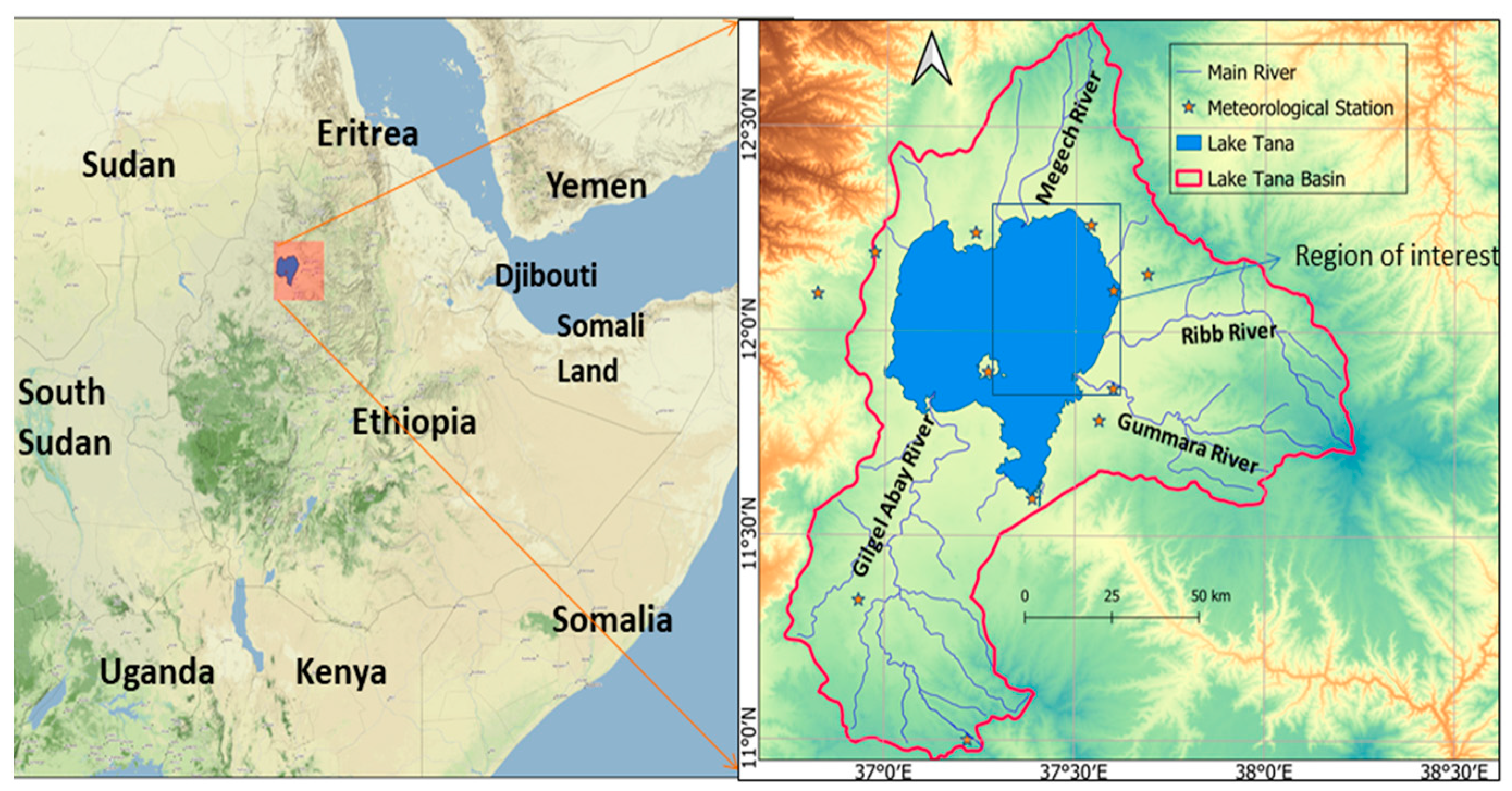
2.1. Study Area and In Situ Data

Lake Tana, located in the northwestern region of Ethiopia (Figure 1), has a surface area of about 3600 km2 and an average depth of 9 m. It has four major tributary rivers, namely, Ribb, Megech, Gummara, and Gilgel Abbay, collecting water from a total catchment area of 15,000 km2 [58]. Lake Tana lies under the tropical highlands with a mean annual rainfall of 1280 mm. The rainfall pattern is unimodal with wet and dry seasons from June to September and October to May, respectively, whereas an additional light rainy season (February–May) has also been reported occasionally [59]. The annual average temperature is 20 °C with a range of 9° to 25° (Figure 2). Rainfall and temperature data for 2020 were obtained from the Ethiopian Meteorological Agency Bahir Dar branch (http://www.ethiomet.gov.et, accessed on 23 October 2021). The data were collected from different gauged stations near Lake Tana (Figure 1). Daily temperature and rainfall data were averaged for each month (Figure 2).

2.2. Satellite Data

In order to examine the dynamics of the water hyacinth, we focused our study on the northeastern part of the lake where this invasive species is currently observed, although additional suitable areas for its growth have been suggested previously in the lake [25]. Sentinel-2A/B cloud-free images (Level-1C and Level-2A) were selected and downloaded from the Copernicus Open Access Hub (https://scihub.copernicus.eu/dhus/#/home, accessed on 28 October 2021) for the study period (2020), one per month (Table 1). A one-month time interval was sufficient to capture general patterns of water hyacinth cover and biomass changes. The spatial resolution is 10-20-60 m depending on the band and spreads over the visible, near-infrared (NIR), and short-wave infrared regions of the electromagnetic spectrum [60]. The images used for the estimation of Chl-a and TSM concentrations were initially resampled using the bilinear resampling method to 10 m spatial resolution within the open-access Sentinel Application Platform (SNAP) software that is suited to Sentinel data products [50]. Level-1C data were converted to Level-2 data products using the Case 2 Regional Coast Colour processor (C2RCC) as recommended by the European Space Agency and other studies [50,51,52,53,61,62].
The C2RCC is developed for optically complex waters. The processor relies on an extensive database of simulated water-leaving reflectance and TOA radiances and it is based on neural network technology trained in extreme ranges of scattering and absorption properties [61]. The inversion of the water signal and satellite signal is performed by neural networks, which determine the water-leaving radiance from the TOA and retrieve inherent optical properties (IOPs) of the water body. A characterization of optically complex waters through its IOPs is used along with the coastal atmospheres to parameterize radiative transfer models for the atmosphere over the water body. The C2RCC has been improved to cover extreme ranges of scattering and absorption, now using a 5-component bio-optical model. The C2RCC outputs are surface reflectance, IOPs, and water quality, both chl-a and TSM, and provides the possibility to add additional background information such as salinity, elevation, ozone, temperature, and air pressure. At the time of the research, C2RCC included two versions: a version called the normal net (C2RCC), with typical ranges of IOPS, and an extreme net version (CX), for extreme ranges of absorption and scattering. The images were processed here according to the default processing parameters of C2RCC. According to Pereira-Sandoval et al. (2019), who evaluated several atmospheric correction algorithms for inland waters, C2RCC performed better for optically complex water bodies (i.e., mesotrophic to hypertrophic), similar to Lake Tana [51]. The average concentrations of Chl-a and TSM were calculated using the Statistics Analysis tool in SNAP. All the pixels within the study area identified as a water surface were considered in estimating the average concentration of Chl-a and TSM.
Reflectance values of Sentinel-2 data products before (Level-1C TOA) and after atmospheric correction (Level-2A BOA), the latter from both C2RCC and Sen2Cor processors, were compared across the visible and NIR bands to evaluate the atmospheric effect on the spectrum’s signature. Four control points were selected to qualitatively inspect the water reflectance: water hyacinth (P1), near the water hyacinth (P2), at the mouth of the tributary river (P3), and at the center of the lake over clear waters (P4) (Figure 3a). The reflectance spectrum (Level-1C TOA, BOA Sen2Cor, and BOA C2RCC) was extracted using the tool “pin manager” and “spectrum view” in SNAP software.
The Normalized Difference Vegetation Index (NDVI) was calculated in the QGIS software using the reflectance spectral bands (Level 2A BOA Sen2Cor): band 4 (red) and band 8 (NIR), as follows:
NDVI = [band 8 − band 4]/[band 8 + band 4]
to investigate the seasonal variation in water hyacinth’s biomass and cover. The water hyacinth cover was determined by NDVI values ranging from 0.6 to 0.95, using spectral reflectance image analysis, a true color composite overlaid for comparison, visual supervision, and field information. The average biomass, expressed in mean NDVI, and cover at the northeastern part of Lake Tana in every image were measured using the QGIS “Zonal statistics” plugin. The water hyacinth biomass was multiplied by the total cover per image, and the total biomass cover change between images during 2020 was calculated.

3. Results

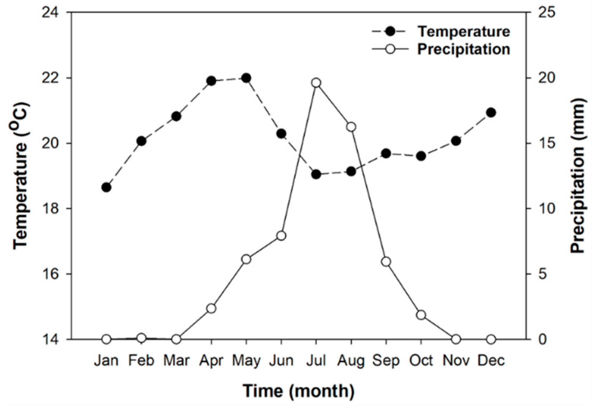
3.1. In Situ Data: Precipitation and Temperature

A clear seasonal variability in precipitation and temperature was observed during 2020. The wet season lasted from April to October, showing the maximum monthly mean precipitation value in July (20 mm), and the dry season during the rest of the year (Figure 2). In accordance with this, the temperature was lowest from June to September, during the wet season, and started to increase in November. Maximum mean values were observed in April and May (~23 °C), although maximum and minimum monthly mean values did not vary noticeably (between 18 and 23 °C).

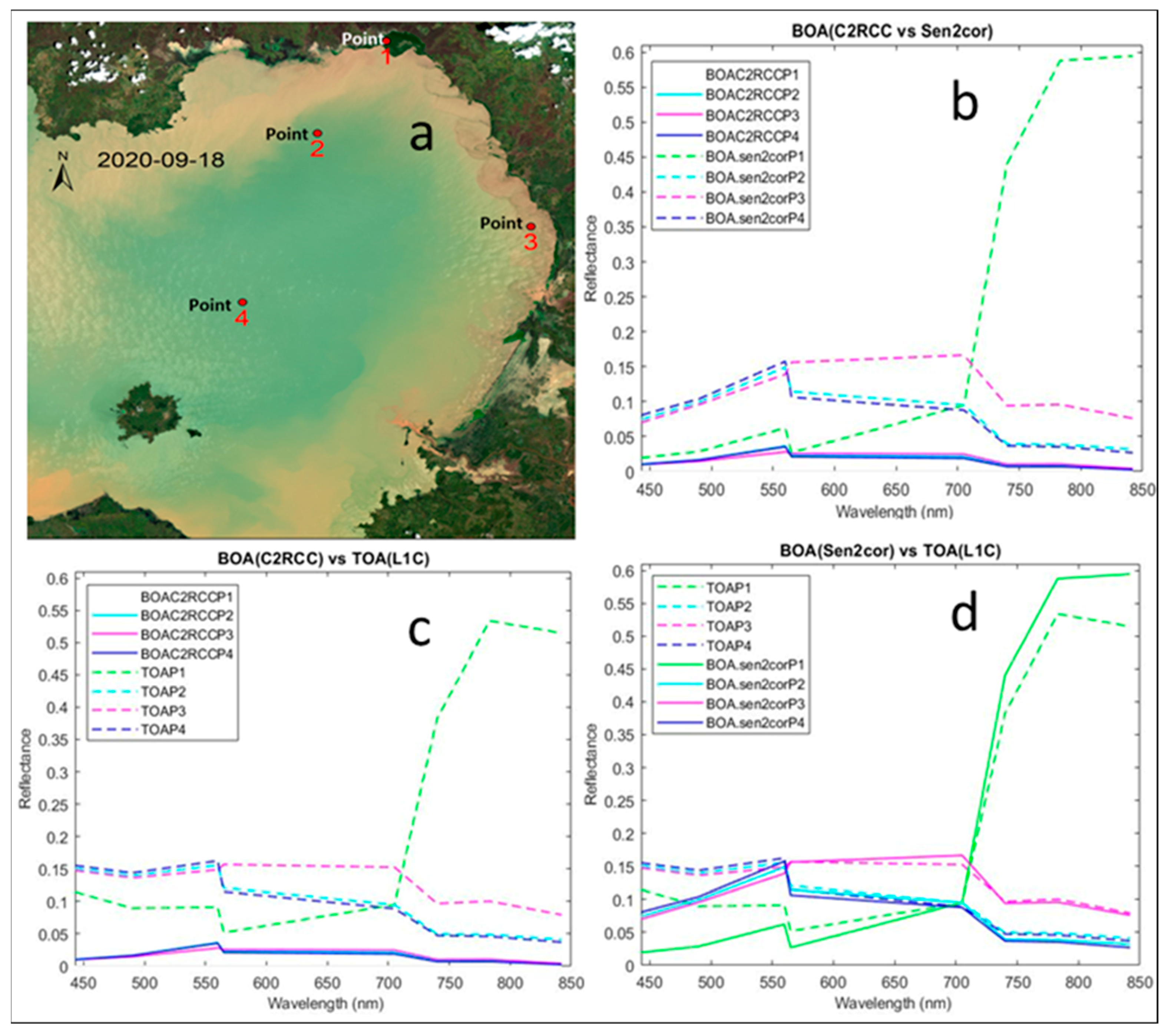
3.2. Atmospheric Correction for Sentinel-2 Imagery

Comparison of Sentinel-2 reflectance values of the water and water hyacinth at different locations in Lake Tana using three distinct image levels and products showed clear differences. The water reflectance values derived from the Sen2Cor product at the BOA level (BOAsen2cor) at points P2, P3, and P4 were higher compared to the BOA reflectance values derived from C2RCC (BOAC2RCC) for the full range of wavelengths (Figure 3b). The lower values of reflectance determined after atmospheric corrections compared to TOA were due to the removal of atmospheric effects (e.g., Rayleigh scattering, water vapor, and aerosols). Moreover, both C2RCC and Sen2Cor products at the BOA level showed a lower reflectance value for water (P4) compared with Sentinel-2 images at TOA Level-1C (Figure 3c,d). The C2RCC processor did not produce a value for P1, a water hyacinth zone, as it was considered as land (masked data) (Figure 3b,c). In contrast, the Sen2Cor processor did return a value for water hyacinth reflectance at P1. This value was lower (<0.1) than the values from other processors all the way up to the 704 nm wavelength. However, above that wavelength, over the red-edge and NIR spectrum, the reflectance of water hyacinth was much higher (~0.6). Similar results were obtained after evaluation of other, different control points over the lake (not included in this study).

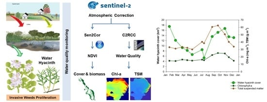
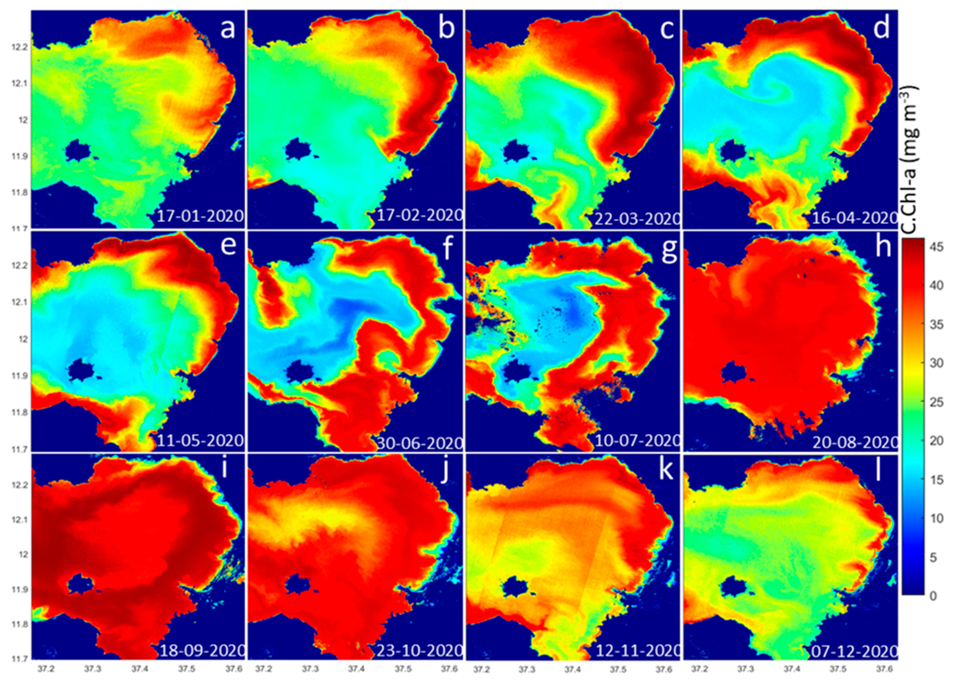
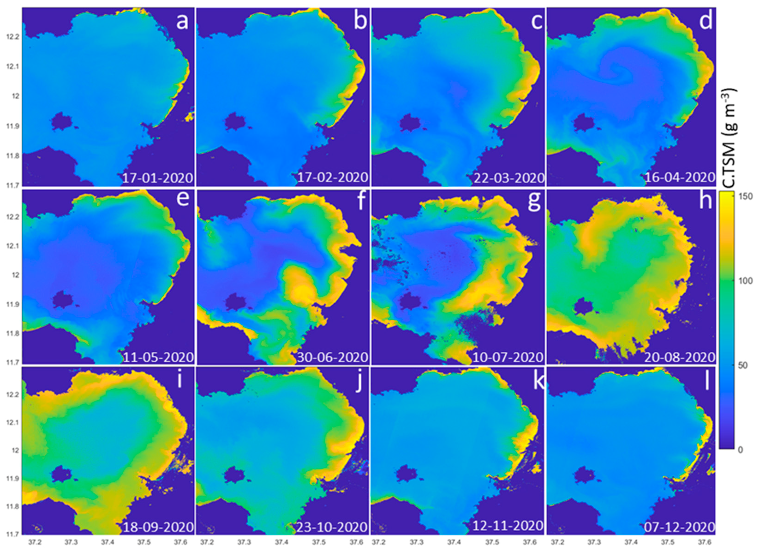
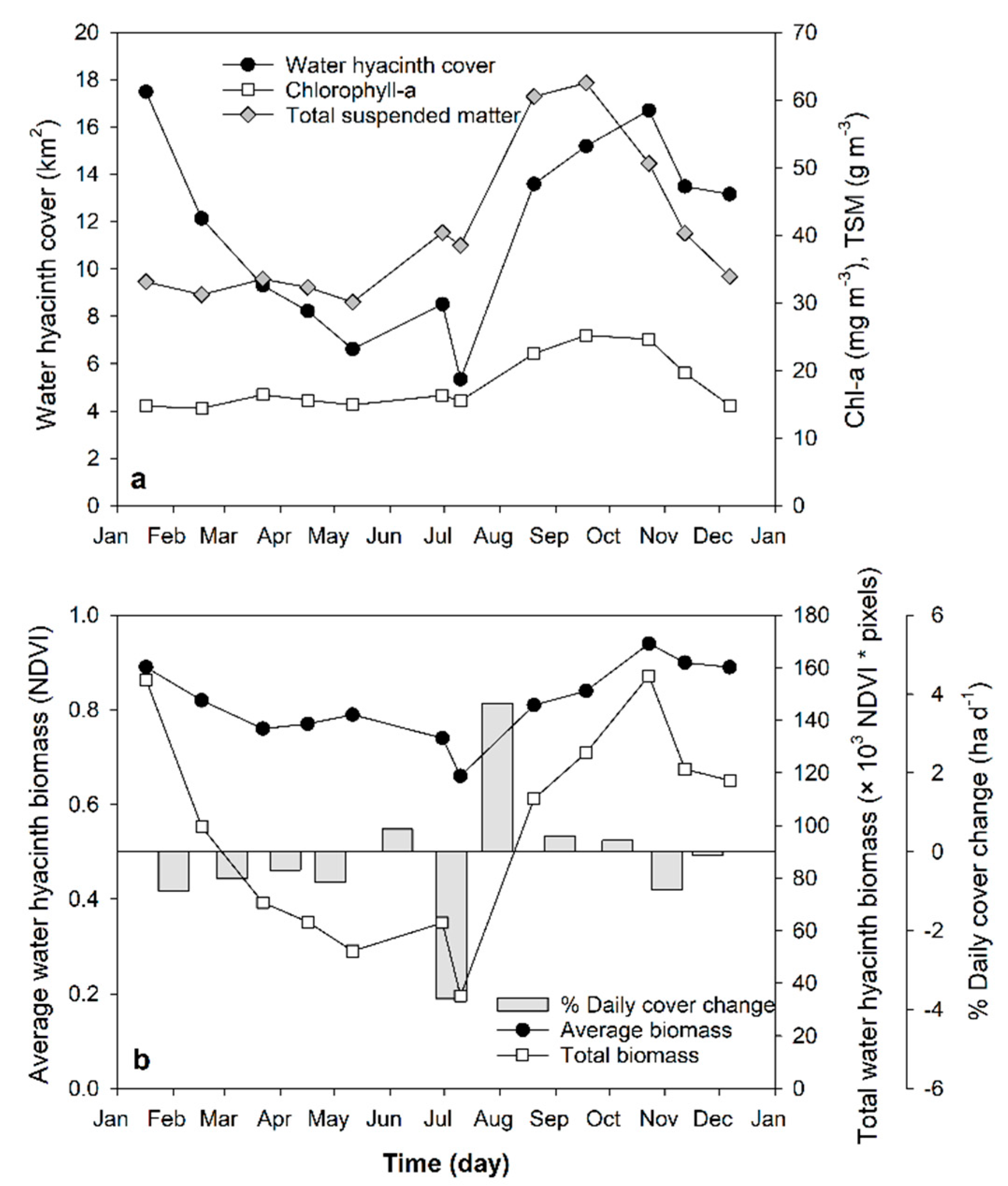
3.3. Water Quality Monitoring

A significant variation in Chl-a and TSM was observed over the one-year study period in Lake Tana. The Chl-a concentration varied between seasons with the highest values at the end of the wet season (August–October 2020). The minimum Chl-a concentration was recorded in February 2020 (4.45 mg m−3) during the dry season (Figure 4b). In that period, the highest concentration was observed at the northeastern and eastern part of the lake where the mouths of the three major and other small tributary rivers are located (Figure 1). Concentrations increased progressively along the entire east shore and the southwestern part during the rainy season, reaching values over 40 mg m−3 by the end of August (Figure 4h). TSM concentrations also varied in space and time during the study year (Figure 5), showing a spatial pattern similar to that of Chl-a. However, the lowest mean values were observed in May (30.1 g m−3, Figure 5e) and the highest during the late wet season, in September (62.5 g m−3, Figure 5i). Generally, higher TSM values were encountered near the northeastern and eastern shores of the lake.

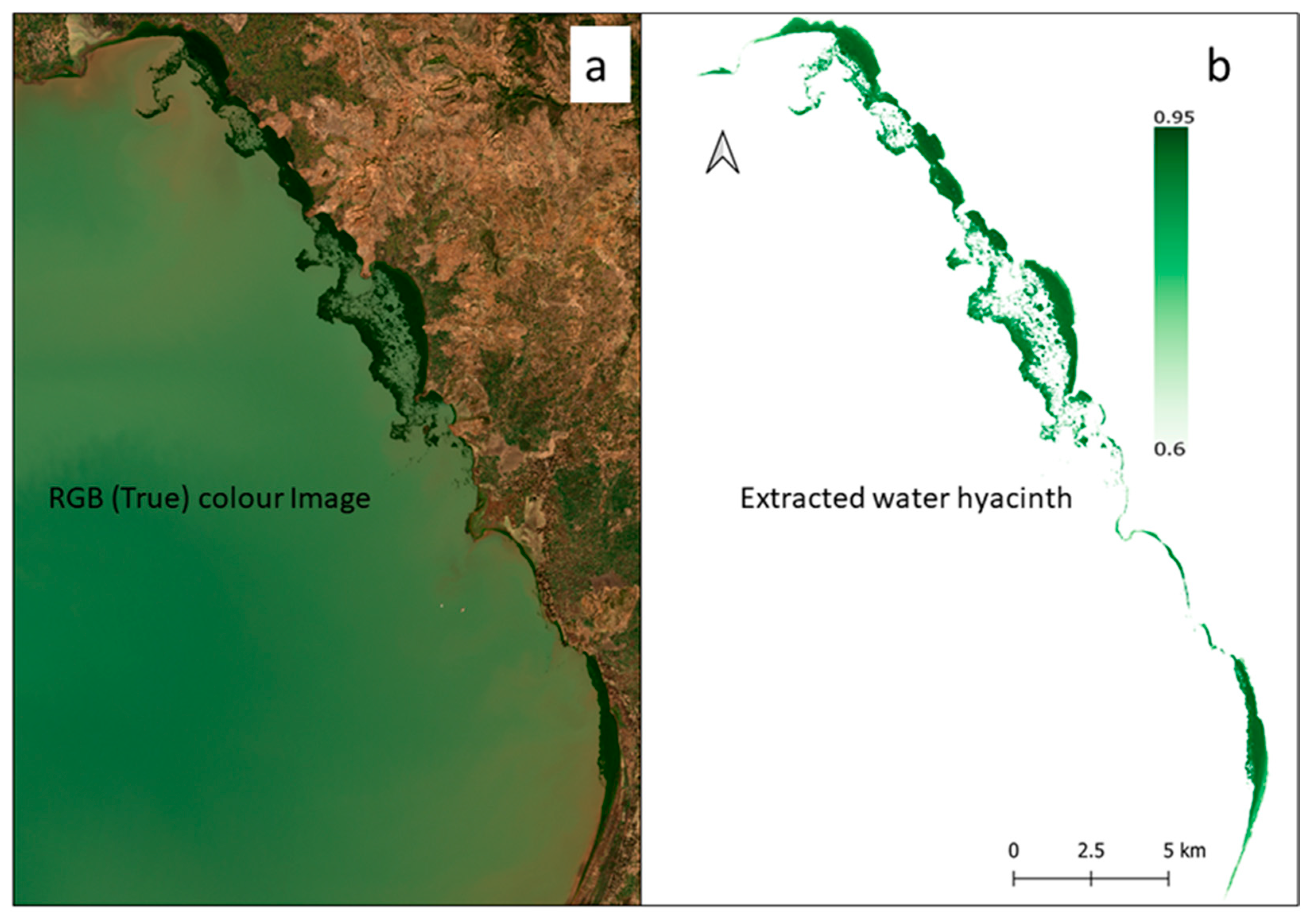
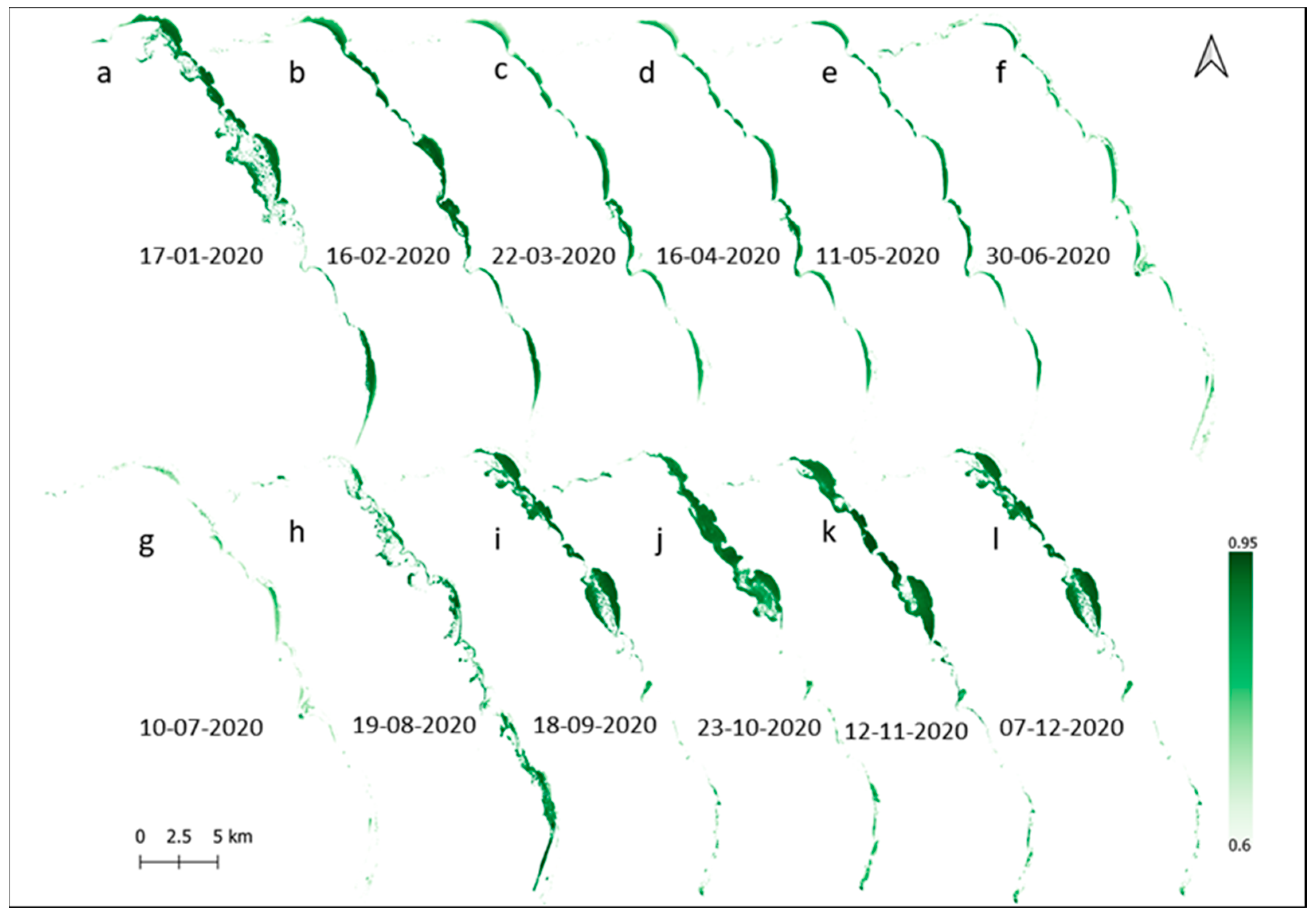
3.4. Water Hyacinth Monitoring

Water hyacinth was identified and mapped by computing NDVI values (0.6–0.95) derived from the Sentinel-2 Level-2 images using the Sen2Cor products. Figure 6a indicates an example of a RGB composite scene on 17 January 2020 of the northeastern part of Lake Tana, whereas Figure 6b shows the water hyacinth coverage at 10 m spatial resolution on the same day, highlighting the accurate performance of these NDVI settings. NDVI maps showed that water hyacinth expansion varied both in space and time during the study period. The water hyacinth cover and biomass started to decrease in February 2020, reaching its lowest values in July 2020 (Figure 7g). From then onward, water hyacinth proliferated rapidly in the northeastern part of the lake and expanded continuously until the end of October 2020 (Figure 7j). Peaks in cover and biomass were observed in October, just a month after the peak of Chl-a and TSM concentrations observed in September (end of the main wet season) (Figure 8a,b). A significant positive correlation was found between the temporal series of water hyacinth coverage and Chl-a concentration (Pearson coefficient = 0.53; n = 12; p = 0.05). Both cover and biomass showed the same trend and started to decrease in November 2020. The average biomass ranged from 0.66 to 0.94 (Figure 8b). Overall, the one-year analysis results showed that water hyacinth cover and biomass were higher in the late wet season (spring) and lower in the dry and early wet season. The changes in biomass and cover went in parallel, i.e., the highest biomass (average NDVI) per pixel and total biomass were observed when the cover was also highest (Figure 8b). The greatest rate of decrease was observed in July 2020 in just over two weeks, whereas the highest increase was observed in August (both roughly 4% d−1).

4. Discussion

4.1. Monitoring Lake Tana with the Sentinel-2 Satellites

We used high-resolution Sentinel-2 images to estimate both the cover and biomass of water hyacinth in Lake Tana by calculating NDVI, to assess seasonal dynamics during 2020, and to establish their relation with proxies of biogeochemical water quality parameters, namely Chl-a and TSM. The water hyacinth is an aquatic invasive alien species that has expanded rapidly across the planet in fresh water systems, resulting in serious problems for the affected ecosystems [9,10]. Therefore, monitoring the temporal and spatial dynamics of the water hyacinth is essential for managers to be able to adequately respond and implement appropriate measures. Remote sensing tools are very useful for water quality management, for implementing near-real-time monitoring strategies, and for mapping invasive species especially in remote environments, areas with limited resources or in very dynamic systems, as the one investigated in this study. Our multi-sensor approach might advance previous studies that aimed to characterize water hyacinth and biogeochemical water quality over inland water masses using coarser-spatial-resolution imagery [26,27,37,44,63] (Table S1), as the complex variability in the inland water environment was revealed in all the synoptic satellite-derived maps presented in this study (Figure 4, Figure 5, Figure 6 and Figure 7).
In addition, compensation for atmospheric scattering and absorption and for surface reflection at the air–water interface (sunglint) from the signal measured at the TOA is mandatory over coastal and inland water masses [48]. Recognizing the differences in spatial and spectral sampling under various atmospheric, sunlight, and aquatic conditions to create a data record for coastal and inland water quality monitoring is a critical task [48,64]. This information is vital to ensure a precise near-real-time monitoring with Sentinel-2 satellites. Land and water surface reflectance values over Lake Tana are affected by atmospheric conditions; thus, they need to be corrected using appropriate pre-designed algorithms [65]. However, only few studies have used satellite images properly corrected for atmospheric issues when estimating water hyacinth cover or biomass (e.g., Ghoussein et al. (2019) using Sen2Cor [66]). In this study, we applied two pre-processing processors, the C2RCC and Sen2Cor atmospheric correction algorithms, to generate Level-2C products and compared them with Level-1C reflectance values on water and water hyacinth pixels (Figure 3c,d). Over inland waters, TOA products might lead to large uncertainties in satellite data products, thus limiting the detection of subtle variabilities in aquatic ecosystems [48,64]. The C2RCC processor includes a sunglint correction in addition to the atmospheric correction [50,61], a significant advancement when mapping inland waters [48,64] compared to Sen2Cor, which is a land-focused processor. Therefore, C2RCC is optimal for water quality retrieval over complex water masses. Sen2Cor, aimed at performing over land cover, allowed us to identify and map water hyacinth and characterize its expansion. In order to achieve higher-quality downstream products in freshwater or marine ecosystems, atmospheric correction is mandatory, as already demonstrated in several studies [48,50,51,52,53,62,64].
Few studies in Lake Tana used a similar spatial resolution as the one used here, 10 m, and none with a known atmospheric correction. Dersseh et al. (2020) employed Sentinel-2 with Level-1C (TOA) [37]. Worqlul et al. (2020) used the PlanetScope imagery with higher spatial resolution (3–5 m) to identify water hyacinth by supervised classification; however, the atmospheric correction was not defined [26]. Our results, in comparison with other studies (Table S1), used BOA reflectance products from Sen2Cor, allowing us to accurately and consistently monitor water hyacinth cover and biomass along the year and improve the relationship with water quality parameters (i.e., Chl-a and TSM) estimated with C2RCC. In our work, water hyacinth was identified and mapped by computing NDVI values (range of 0.6–0.95) derived from the Sentinel-2 Level-2 images (Figure 6 and Figure 7). Dersseh et al. (2020) observed both lower NDVI levels and a range associated with water hyacinth (range of 0.27–0.47) [37], much lower than those observed in this work, probably due to the application of Sentinel-2 Level-1C (TOA) images without atmospheric correction. The increased sensitivity offered by the approach used here is crucial to distinguish the changes in both cover and biomass over different atmospheric conditions. To date, this is the first work in which the NDVI was calculated from L2A BOA Sen2Cor to study the water hyacinth cover in the lake. Due to absence of other macrophytes floating on the water, the expansion of water hyacinth can be studied directly using NDVI from multispectral satellite images without the need to apply machine-learning algorithms, which are complex black-box models. Although remote sensing tools are accessible and cost-effective that permit the monitoring of large water bodies, data should be processed adequately to obtain appropriate and consistent results and allow efficient management.

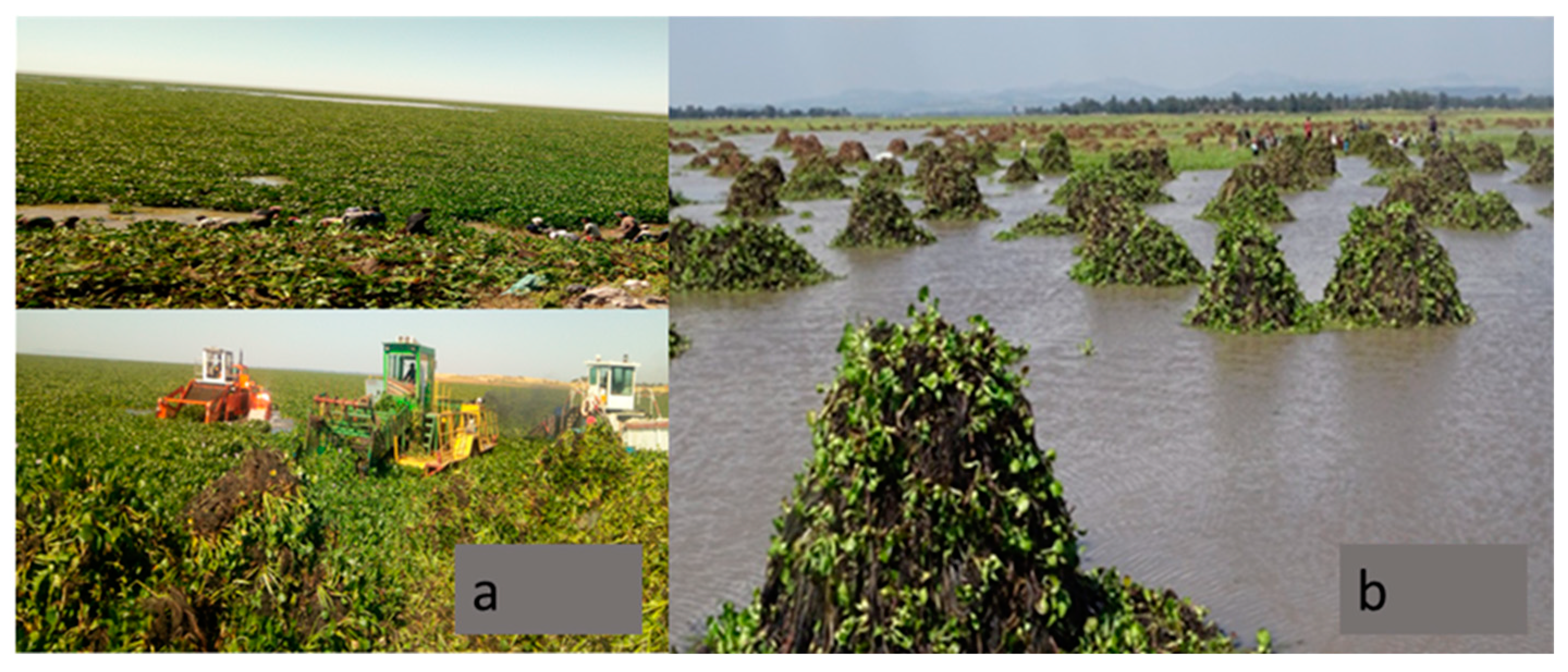
4.2. Water Hyacinth Assessment

Our NDVI maps at 10 m spatial resolution showed that water hyacinth expansion varied both in space and in time. In January 2020, the water hyacinth extended along the entire eastern shore with the highest biomass observed in the northern part. The cover progressively decreased, showing its lowest values in July 2020. Thereafter, the water hyacinth started to proliferate rapidly along the shore, although the highest cover was observed in the northeastern part of the lake. The highest cover and NDVI were observed in October 2020 at the end of the wet season (Figure 8), subsequently decreasing from November to December 2020. These results confirm the previous findings by Worqlul et al. (2020), who found that the highest water hyacinth coverage was observed at the end of the wet season (October–November 2017) [26]. However, Dersseh et al. (2020) found that the highest cover shifted somewhat over the years from October in 2016 and 2017 to December in 2018 and 2019 [37]. Such peaks at the end of the wet season have been observed elsewhere, such as in Lake Victoria [34,39,66,67] (Table S1).
Mechanical removal interventions carried out by the local communities and coordinated by the Federal Government of Ethiopia were reported by the Lake Tana Protection Agency for the study year (Figure 9). In December 2020, it was reported that about 80% of the water hyacinth cover and biomass were removed from Lake Tana (Lake Tana Protection Agency, 2020). Although we recorded a further decrease in cover and biomass, in contrast to a previous study [37], our results did not confirm the reported amount of change in December 2020, suggesting that the percentage of the removal in the report was overestimated. If, however, the water hyacinth removed was indeed that high, the fact that, only a month later, the biomass level had returned to previous levels only indicates the rapid growth capacity of the water hyacinth and demonstrates that the management practices are not effective.
Removal practices have been employed since 2012 and yet the expansion rate of water hyacinth has not been reduced [37]. In Lake Victoria and other areas, mechanical removal of water hyacinth succeeded in reducing cover with increased labor and logistics costs, however [11,68]. Dersseh et al. (2020) and Worqlul et al. (2020) suggested that the optimal season for physical removal is during the dry season when its cover is minimal [26,37]. However, it should be noted that water hyacinth also acts as a nutrient filter. In fact, the water hyacinth is being used as a eutrophication control tool [9,69]. Therefore, management practices should also consider those aspects carefully. The application of satellite images at higher temporal resolution (5 day-revisit with the Sentinel-2 mission) could allow more precise short-term estimation of the extent and effectiveness of such management routines.
The peak in water hyacinth, cover, and biomass occurred just one month after the peaks of Chl-a and TSM. In addition, the spatial pattern of TSM, Chl-a, and water hyacinth was similar, with the highest values in the same northeastern part of the lake during the same periods. Previous studies in the lake showed a similar trend in TSM [26] with the highest values coinciding with the rainy period and the influx of material from the watershed. In terms of the primary producers, Lake Tana is a nutrient-limited fresh-water lake during the dry season and receives a substantial amount of nutrients from its catchment in the wet season [70,71]. This input of nutrients and sediment load from the upper catchment through the main rivers, two of which discharge into the eastern part of the lake, could trigger the proliferation of both water column phytoplankton and water hyacinth. In addition, both the water hyacinth and phytoplankton could potentially benefit from the nutrients stored in the soils of the cultivated land adjacent to the lake shores that are inundated during the wet season, as previously suggested by Dersseh et al. (2020). Although no direct measurements of nutrient release from the soil and sediments exist, the correlation between lake level and water hyacinth cover supports this hypothesis [26,37]. Ultimately, the rapid water hyacinth expansion at a certain time of the year in Lake Tana is likely a combination of nutrient riverine inputs and sediment load, wind redistribution, water level shifts diluting or concentrating nutrients, re-suspension of sediment and nutrient by turbulence, and possibly changes in light and temperature, creating the optimum conditions for growth. Further studies are necessary to identify the precise factors driving the water hyacinth changes throughout the year and across the lake and to offer insight for appropriate management actions. The ability to process, using the correct tools, and visualize both the short- and medium-term changes across the entire lake can aid greatly for enhanced monitoring of water quality deterioration. This is essential in developing countries with limited economic and logistic resources, such as Ethiopia, compared to the traditional costly and time-consuming field analysis of water quality. However, in the meantime, more in situ data are necessary in order to validate water quality parameters to address potential algorithm uncertainties. In addition, a complete evaluation of the seasonal dynamics on the whole Sentinel-2 time series (since 2015) should be carried out in the future, supplemented with data from the Landsat satellites constellation.

5. Conclusions

In this study, we evaluated the spatiotemporal variation in the water hyacinth dynamics and biogeochemical water quality variables, namely Chl-a and TSM concentrations, in Lake Tana during 2020 using remote sensing imagery. The application of the Sen2Cor and C2RCC processors to correct the Sentinel-2 satellite images successfully identified the water hyacinth pixels and allowed evaluation of the plant cover and biomass, as well as mapping of the Chl-a and TSM concentration. All variables showed remarkable spatial and temporal variation within the period of the study. The highest values for water hyacinth cover and biomass were observed in the northern and northeastern parts of the lake, where major rivers discharge into the lake, in the late wet season, following the peaked Chl-a and TSM values during the wet season. Although the exact drivers are not well known, and more specific studies are necessary, this pattern suggests the importance of nutrient and sediment load inputs from the catchment area and adjacent agricultural lands and the need to control them in order to control water hyacinth growth and expansion. As the water hyacinth also acts as a nutrient control mechanism, management practices should carefully plan any actions to remove biomass or eradicate this invasive species from the system. However, in the case of Lake Tana, where nutrients are historically limited, removal of the water hyacinth is essential. Satellite images are a powerful tool to monitor in detail this aquatic invasive alien species as well as water quality parameters, contributing to the design of management plans in order to reduce its expansion and preserve aquatic ecosystems services in the area. Consequently, the Sentinel-2A/B twin mission of the European Commission’s Copernicus programme is a complementary, synoptic, and powerful tool for inland water monitoring and assessment to improve current practices for managers, as well as to provide insights during environmental crises under a climate change scenario.

Supplementary Materials

The following supporting information can be downloaded at: https://www.mdpi.com/article/10.3390/rs14194921/s1, Table S1: Previous studies related to water hyacinth detection using remote sensing. The parameters, sensor type, resolution, study period and methodology used for the analysis are specified.

Author Contributions

Original idea: T.M. and I.C.; Conceptualization: I.C., T.M., S.H., and S.P.; Methodology: I.C.; Formal Analysis: T.M., I.C., S.H., and S.P.; Resources: I.C. and S.P.; Writing—Original Draft: T.M.; Writing—Review and Editing: I.C., S.H., and S.P.; Visualization: T.M., S.H., S.P., and I.C.; Supervision: I.C. and S.P.; Funding acquisition: I.C. and S.P. All authors have read and agreed to the published version of the manuscript.

Funding

This research was funded by grants RTI2018-098784-J-I00 (Sen2Coast Project) and IJC2019-039382-I (Juan de la Cierva-Incorporación) awarded to Isabel Caballero funded by MCIN/AEI/10.13039/501100011033 and by “ERDF A way of making Europe”. Tadesse Mucheye was funded by the European Commission under the Erasmus Mundus Joint Master Degree Programme in Water and Coastal Management (WACOMA 586596-EPP-1-2017-1-IT-EPPKA1-JMD-MOB grant). Sara Haro was funded by the fellowship of the Fundación Ramón Areces “XXXIII Convocatoria para Ampliación de Estudios en el Extranjero en Ciencias de la Vida y de la Materia”.

Data Availability Statement

The datasets are available on request. The raw data supporting the conclusions of this article will be made available by the authors, without undue reservation, to any qualified researcher.

Acknowledgments

The authors would like to thank the European Space Agency, the European Commission, and the Copernicus program for distributing Sentinel-2. This work represents a contribution to CSIC Thematic Interdisciplinary Platforms PTI TELEDETECT. We also thank Martha B. Dunbar for her English language edits.

Conflicts of Interest

The authors declare no conflict of interest.

References

  1. Ishtiyaq, A.N.; Anisa, B.K.; Abdul, H. Evaluation of Seasonal Variability in Surface Water Quality of Shallow Valley Lake, Kashmir, India, Using Multivariate Statistical Techniques. Pollution 2017, 3, 349–362. [Google Scholar]
  2. Nsenga Kumwimba, M.; Meng, F.; Iseyemi, O.; Moore, M.T.; Zhu, B.; Tao, W.; Liang, T.J.; Ilunga, L. Removal of Non-Point Source Pollutants from Domestic Sewage and Agricultural Runoff by Vegetated Drainage Ditches (VDDs): Design, Mechanism, Management Strategies, and Future Directions. Sci. Total Environ. 2018, 639, 742–759. [Google Scholar] [CrossRef] [PubMed]
  3. Tauchnitz, N.; Kurzius, F.; Rupp, H.; Schmidt, G.; Hauser, B.; Schrödter, M.; Meissner, R. Assessment of Pesticide Inputs into Surface Waters by Agricultural and Urban Sources-A Case Study in the Querne/Weida Catchment, Central Germany. Environ. Pollut. 2020, 267, 115186. [Google Scholar] [CrossRef]
  4. Meybeck, M.; Kuusisto, E.; Mäkelä, A.; Mälkki, E. Water Quality; United Nations Environment Programme and the World Health Organization: Geneva, Switzerland, 1996; ISBN 0419223207. [Google Scholar]
  5. Davis, A.M.; Pearson, R.G.; Brodie, J.E.; Butler, B. Review and Conceptual Models of Agricultural Impacts and Water Quality in Waterways of the Great Barrier Reef Catchment Area. Mar. Freshw. Res. 2017, 68, 1–19. [Google Scholar] [CrossRef]
  6. Reid, A.J.; Carlson, A.K.; Creed, I.F.; Eliason, E.J.; Gell, P.A.; Johnson, P.T.J.; Kidd, K.A.; MacCormack, T.J.; Olden, J.D.; Ormerod, S.J.; et al. Emerging Threats and Persistent Conservation Challenges for Freshwater Biodiversity. Biol. Rev. 2019, 94, 849–873. [Google Scholar] [CrossRef] [Green Version]
  7. Meshesha, T.W.; Wang, J.; Melaku, N.D. Modelling Spatiotemporal Patterns of Water Quality and Its Impacts on Aquatic Ecosystem in the Cold Climate Region of Alberta, Canada. J. Hydrol. 2020, 587, 124952. [Google Scholar] [CrossRef]
  8. Cuffney, T.F.; Kennen, J.G.; Waite, I.R. Aquatic Ecosystems as Indicators of Status and Trends in Water Quality; Elsevier Ltd.: Amsterdam, The Netherlands, 2014; Volume 1, ISBN 9780123821836. [Google Scholar]
  9. Kleinschroth, F.; Winton, R.S.; Calamita, E.; Niggemann, F.; Botter, M.; Wehrli, B.; Ghazoul, J. Living with Floating Vegetation Invasions. Ambio 2021, 50, 125–137. [Google Scholar] [CrossRef] [PubMed]
  10. Murphy, B.R. Ecological and Socio-Economic Impacts of Invasive Water Hyacinth (Eichhornia crassipes): A Review. Freshw. Biol. 2010, 55, 282–298. [Google Scholar] [CrossRef]
  11. Makhanu, K.S. Impact of Water Hyacinth on Lake Victoria. In Water and Sanitation for All—Partnerships and Innovations: Proceedings of the 23rd WEDC International Conference, Durban, South Africa, 1–5 September 1997; Pickford, J., Elson, B., Ince, M., Larcher, P., Miles, D., Parr, J., Reed, B., Barker, P., Sansom, K., Saywell, D., et al., Eds.; Water, Engineering and Development Centre, Loughborough University of Technology, WEDC: Loughborough, UK; pp. 165–166.
  12. Thamaga, K.H.; Dube, T. Remote Sensing of Invasive Water Hyacinth (Eichhornia crassipes): A Review on Applications and Challenges. Remote Sens. Appl. Soc. Environ. 2018, 10, 36–46. [Google Scholar] [CrossRef]
  13. Dersseh, M.G.; Kibret, A.A.; Tilahun, S.A.; Worqlul, A.W.; Moges, M.A.; Dagnew, D.C.; Abebe, W.B.; Melesse, A.M. Potential of Water Hyacinth Infestation on Lake Tana, Ethiopia: A Prediction Using a GIS-Based Multi-Criteria Technique. Water 2019, 11, 1921. [Google Scholar] [CrossRef] [Green Version]
  14. Worku, M. Lake Tana as Biosphere Reserve: Review. J. Tour. Hosp. 2017, 6, 5–6. [Google Scholar] [CrossRef]
  15. Atnafu, N.; Dejen, E.; Vijverberg, J. Assessment of the Ecological Status and Threats of Welala and Shesher Wetlands, Lake Tana Sub-Basin (Ethiopia). J. Water Resour. Prot. 2011, 3, 540–547. [Google Scholar] [CrossRef] [Green Version]
  16. Nagelkerke, L.A.J.; Mina, M.V.; Wudneh, T.; Sibbing, F.A.; Osse, J.W.M. In Lake Tana, a Unique Fish Fauna Needs Protection: These Ethiopian Barbs Constitute the Only Cyprinid Species Flock Known That Has Not Been Damaged by Human Influences. Bioscience 1995, 45, 772–775. [Google Scholar] [CrossRef]
  17. Alemayehu, T.; McCartney, M.; Kebede, S. The Water Resource Implications of Planned Development in the Lake Tana Catchment, Ethiopia. Ecohydrol. Hydrobiol. 2010, 10, 211–221. [Google Scholar] [CrossRef]
  18. Lemma, H.; Frankl, A.; Griensven, A.; Poesen, J.; Adgo, E.; Nyssen, J. Identifying Erosion Hotspots in Lake Tana Basin from a Multisite Soil and Water Assessment Tool Validation: Opportunity for Land Managers. L. Degrad. Dev. 2019, 30, 1449–1467. [Google Scholar] [CrossRef] [Green Version]
  19. Moges, M.A.; Moges, S.A. Characteristics of Future Extreme Precipitation and Temperature in Lake Tana Basin, Ethiopia; Elsevier Inc.: Amsterdam, The Netherlands, 2019. [Google Scholar]
  20. Wubie, M.A.; Assen, M. Effects of Land Cover Changes and Slope Gradient on Soil Quality in the Gumara Watershed, Lake Tana Basin of North–West Ethiopia. Model. Earth Syst. Environ. 2020, 6, 85–97. [Google Scholar] [CrossRef] [Green Version]
  21. Minale, A.; Rao, K. Hydrological Dynamics and Human Impact on Ecosystems of Lake Tana, Northwestern Ethiopia. Ethiop. J. Environ. Stud. Manag. 2011, 4. [Google Scholar] [CrossRef] [Green Version]
  22. Karlberg, L.; Hoff, H.; Amsalu, T.; Andersson, K.; Binnington, T.; Flores-López, F.; de Bruin, A.; Gebrehiwot, S.G.; Gedif, B.; zur Heide, F.; et al. Tackling Complexity: Understanding the Food-Energy-Environment Nexus in Ethiopia’s Lake TANA Sub-Basin. Water Altern. 2015, 8, 710–734. [Google Scholar]
  23. Ligdi, E.E.; Mohssine, E.K.; Meire, P. Ecohydrological Status of Lake Tana—A Shallow Highland Lake in the Blue Nile (Abbay) Basin in Ethiopia: Review. Ecohydrol. Hydrobiol. 2010, 10, 109–122. [Google Scholar] [CrossRef]
  24. Mucheye, T.; Yitaferu, B.; Zenebe, A. Significance of Wetlands for Sediment and Nutrient Reduction in Lake Tana Sub-Basin, Upper Blue Nile Basin, Ethiopia. Sustain. Water Resour. Manag. 2018, 4, 567–572. [Google Scholar] [CrossRef]
  25. Dersseh, M.G.; Melesse, A.M.; Tilahun, S.A.; Abate, M.; Dagnew, D.C. Water Hyacinth: Review of Its Impacts on Hydrology and Ecosystem Services—Lessons for Management of Lake Tana. In Extreme Hydrology and Climate Variability; Elsevier: Amsterdam, The Netherlands, 2019; Volume 1824, pp. 237–251. ISBN 9780128159989. [Google Scholar]
  26. Worqlul, A.W.; Ayana, E.K.; Dile, Y.T.; Moges, M.A.; Dersseh, M.G.; Tegegne, G.; Kibret, S. Spatiotemporal Dynamics and Environmental Controlling Factors of the Lake Tana Water Hyacinth in Ethiopia. Remote Sens. 2020, 12, 2706. [Google Scholar] [CrossRef]
  27. Asmare, T.; Demissie, B.; Nigusse, A.G.; GebreKidan, A. Detecting Spatiotemporal Expansion of Water Hyacinth (Eichhornia crassipes) in Lake Tana, Northern Ethiopia. J. Indian Soc. Remote Sens. 2020, 48, 751–764. [Google Scholar] [CrossRef]
  28. Ritchie, J.C.; Zimba, P.V.; Everitt, J.H. Remote Sensing Techniques to Assess Water Quality. Photogramm. Eng. Remote Sens. 2003, 69, 695–704. [Google Scholar] [CrossRef] [Green Version]
  29. Schaeffer, B.A.; Schaeffer, K.G.; Keith, D.; Lunetta, R.S.; Conmy, R.; Gould, R.W. International Journal of Remote Sensing Barriers to Adopting Satellite Remote Sensing for Water Quality Management. Int. J. Remote Sens. 2013, 34, 7534–7544. [Google Scholar] [CrossRef]
  30. Shekede, M.D.; Kusangaya, S.; Schmidt, K. Spatio-Temporal Variations of Aquatic Weeds Abundance and Coverage in Lake Chivero, Zimbabwe. Phys. Chem. Earth 2008, 33, 714–721. [Google Scholar] [CrossRef]
  31. Cavalli, R.M.; Fusilli, L.; Laneve, G.; Pascucci, S.; Palombo, A.; Pignatti, S.; Santini, F. Lake Victoria Aquatic Weeds Monitoring by High Spatial and Spectral Resolution Satellite Imagery. Int. Geosci. Remote Sens. Symp. 2009, 2, 1048–1051. [Google Scholar] [CrossRef]
  32. Kiage, L.M.; Obuoyo, J. The Potential Link Between El Nino and Water Hyacinth Blooms in Winam Gulf of Lake Victoria, East Africa: Evidence from Satellite Imagery. Water Resour. Manag. 2011, 25, 3931–3945. [Google Scholar] [CrossRef]
  33. Dube, T.; Gumindoga, W.; Chawira, M. Detection of Land Cover Changes around Lake Mutirikwi, Zimbabwe, Based on Traditional Remote Sensing Image Classification Techniques. Afr. J. Aquat. Sci. 2014, 39, 89–95. [Google Scholar] [CrossRef]
  34. Ongore, C.O.; Aura, C.M.; Ogari, Z.; Njiru, J.M.; Nyamweya, C.S. Spatial-Temporal Dynamics of Water Hyacinth, Eichhornia crassipes (Mart.) and Other Macrophytes and Their Impact on Fisheries in Lake Victoria, Kenya. J. Great Lakes Res. 2018, 44, 1273–1280. [Google Scholar] [CrossRef]
  35. Singh, G.; Reynolds, C.; Byrne, M.; Rosman, B. A Remote Sensing Method to Monitor Water, Aquatic Vegetation, and Invasive Water Hyacinth at National Extents. Remote Sens. 2020, 12, 21. [Google Scholar] [CrossRef]
  36. Djihouessi, M.B.; Tigo, B.A.; Aina, M.P. The Use of Nutrient Budget Approach for Informing Eutrophication Management in Urbanised Shallow Coastal Lakes: A Case Study from Lake Nokoué in Benin. Ecohydrol. Hydrobiol. 2021, 21, 341–353. [Google Scholar] [CrossRef]
  37. Dersseh, M.G.; Tilahun, S.A.; Worqlul, A.W.; Moges, M.A.; Abebe, W.B.; Mhiret, D.A.; Melesse, A.M. Spatial and Temporal Dynamics of Water Hyacinth and Its Linkage with Lake-Level Fluctuation: Lake Tana, a Sub-Humid Region of the Ethiopian Highlands. Water 2020, 12, 1435. [Google Scholar] [CrossRef]
  38. Al-lami, A.K.; Abbood, R.A.; Al Maliki, A.A.; Al-Ansari, N. Using Vegetation Indices for Monitoring the Spread of Nile Rose Plant in the Tigris River within Wasit Province, Iraq. Remote Sens. Appl. Soc. Environ. 2021, 22, 100471. [Google Scholar] [CrossRef]
  39. Thamaga, K.H.; Dube, T. Understanding Seasonal Dynamics of Invasive Water Hyacinth (Eichhornia crassipes) in the Greater Letaba River System Using Sentinel-2 Satellite Data. GIScience Remote Sens. 2019, 56, 1355–1377. [Google Scholar] [CrossRef]
  40. Karki, S.; Bermejo, R.; Wilkes, R.; Mac Monagail, M.; Daly, E.; Healy, M.; Hanafin, J.; McKinstry, A.; Mellander, P.-E.; Fenton, O.; et al. Mapping Spatial Distribution and Biomass of Intertidal Ulva Blooms Using Machine Learning and Earth Observation. Front. Mar. Sci. 2021, 8, 633128. [Google Scholar] [CrossRef]
  41. Zoffoli, L.M.; Gernez, P.; Rosa, P.; Le, A.; Brando, V.E.; Barillé, A.; Harin, N.; Peters, S.; Poser, K.; Spaias, L.; et al. Remote Sensing of Environment Sentinel-2 Remote Sensing of Zostera Noltei-Dominated Intertidal Seagrass Meadows. Remote Sens. Environ. 2020, 251, 112020. [Google Scholar] [CrossRef]
  42. Haro, S.; Jesus, B.; Oiry, S.; Papaspyrou, S.; Lara, M.; González, C.J.; Corzo, A. Microphytobenthos Spatio-Temporal Dynamics across an Intertidal Gradient Using Random Forest Classification and Sentinel-2 Imagery. Sci. Total Environ. 2022, 804, 149983. [Google Scholar] [CrossRef]
  43. National Aeronautics and Space Administration (NASA). Modis Vegetation Index User’s Guide (MOD13 Series); Version 3.0 (Collection 6); Didan, K., Munoz, A.B., Solano, R., Huete, A., Eds.; NASA: Washington, DC, USA, 2015.
  44. Mukarugwiro, J.A.; Newete, S.W.; Adam, E.; Nsanganwimana, F.; Abutaleb, K.; Byrne, M.J. Mapping Spatio-Temporal Variations in Water Hyacinth (Eichhornia crassipes) Coverage on Rwandan Water Bodies Using Multispectral Imageries. Int. J. Environ. Sci. Technol. 2021, 18, 275–286. [Google Scholar] [CrossRef]
  45. Dube, T.; Mutanga, O.; Sibanda, M.; Bangamwabo, V.; Shoko, C. Testing the Detection and Discrimination Potential of the New Landsat 8 Satellite Data on the Challenging Water Hyacinth (Eichhornia crassipes) in Freshwater Ecosystems. Appl. Geogr. 2017, 84, 11–22. [Google Scholar] [CrossRef]
  46. Dube, T.; Mutanga, O.; Sibanda, M.; Bangamwabo, V.; Shoko, C. Evaluating the Performance of the Newly-Launched Landsat 8 Sensor in Detecting and Mapping the Spatial Configuration of Water Hyacinth (Eichhornia crassipes) in Inland Lakes, Zimbabwe. Phys. Chem. Earth 2017, 100, 101–111. [Google Scholar] [CrossRef]
  47. Dube, T.; Sibanda, M.; Bangamwabo, V.; Shoko, C. Establishing the Link between Urban Land Cover Change and the Proliferation of Aquatic Hyacinth (Eichhornia crassipes) in Harare Metropolitan, Zimbabwe. Phys. Chem. Earth 2018, 108, 19–27. [Google Scholar] [CrossRef]
  48. Pahlevan, N.; Mangin, A.; Balasubramanian, S.V.; Smith, B.; Alikas, K.; Arai, K.; Barbosa, C.; Bélanger, S.; Binding, C.; Bresciani, M.; et al. ACIX-Aqua: A Global Assessment of Atmospheric Correction Methods for Landsat-8 and Sentinel-2 over Lakes, Rivers, and Coastal Waters. Remote Sens. Environ. 2021, 258, 112366. [Google Scholar] [CrossRef]
  49. Bareuther, M.; Klinge, M.; Buerkert, A. Spatio-Temporal Dynamics of Algae and Macrophyte Cover in Urban Lakes: A Remote Sensing Analysis of Bellandur and Varthur Wetlands in Bengaluru, India. Remote Sens. 2020, 12, 3843. [Google Scholar] [CrossRef]
  50. Doerffer, R.; Schiller, H. The MERIS Case 2 Water Algorithm. Int. J. Remote Sens. 2007, 28, 517–535. [Google Scholar] [CrossRef]
  51. Pereira-Sandoval, M.; Ruescas, A.; Urrego, P.; Ruiz-Verdú, A.; Delegido, J.; Tenjo, C.; Soria-Perpinyà, X.; Vicente, E.; Soria, J.; Moreno, J. Evaluation of Atmospheric Correction Algorithms over Spanish Inland Waters for Sentinel-2 Multi Spectral Imagery Data. Remote Sens. 2019, 11, 1469. [Google Scholar] [CrossRef] [Green Version]
  52. Caballero, I.; Stumpf, R.P. Atmospheric Correction for Satellite-Derived Bathymetry in the Caribbean Waters: From a Single Image to Multi-Temporal Approaches Using Sentinel-2A/B. Opt. Express 2020, 28, 11742. [Google Scholar] [CrossRef]
  53. Caballero, I.; Navarro, G. Monitoring CyanoHABs and Water Quality in Laguna Lake (Philippines) with Sentinel-2 Satellites during the 2020 Pacific Typhoon Season. Sci. Total Environ. 2021, 788, 147700. [Google Scholar] [CrossRef]
  54. Sent, G.; Biguino, B.; Favareto, L.; Cruz, J.; Sá, C.; Dogliotti, A.I.; Palma, C.; Brotas, V.; Brito, A.C. Deriving Water Quality Parameters Using Sentinel-2 Imagery: A Case Study in the Sado Estuary, Portugal. Remote Sens. 2021, 13, 1043. [Google Scholar] [CrossRef]
  55. Dekker, A.G.; Vos, R.J.; Peters, S.W.M. Comparison of Remote Sensing Data, Model Results and in Situ Data for Total Suspended Matter (TSM) in the Southern Frisian Lakes. Sci. Total Environ. 2001, 268, 197–214. [Google Scholar] [CrossRef]
  56. Nechad, B.; Ruddick, K.G.; Park, Y. Calibration and Validation of a Generic Multisensor Algorithm for Mapping of Total Suspended Matter in Turbid Waters. Remote Sens. Environ. 2010, 114, 854–866. [Google Scholar] [CrossRef]
  57. Niroumand-Jadidi, M.; Bovolo, F.; Bruzzone, L.; Gege, P. Inter-Comparison of Methods for Chlorophyll-a Retrieval: Sentinel-2 Time-Series Analysis in Italian Lakes. Remote Sens. 2021, 13, 2381. [Google Scholar] [CrossRef]
  58. Woldesenbet, T.A.; Elagib, N.A.; Ribbe, L.; Heinrich, J. Hydrological Responses to Land Use/Cover Changes in the Source Region of the Upper Blue Nile Basin, Ethiopia. Sci. Total Environ. 2017, 575, 724–741. [Google Scholar] [CrossRef] [PubMed]
  59. Mamo, S.; Birhanu, B.; Ayenew, T.; Taye, G. Three-Dimensional Groundwater Flow Modeling to Assess the Impacts of the Increase in Abstraction and Recharge Reduction on the Groundwater, Groundwater Availability and Groundwater-Surface Waters Interaction: A Case of the Rib Catchment in the Lake Tana S. J. Hydrol. Reg. Stud. 2021, 35, 100831. [Google Scholar] [CrossRef]
  60. European Space Agency (ESA). Sentinel-2 User Handbook; ESA: Paris, France, 2015. [Google Scholar]
  61. Brockmann, C.; Doerffer, R.; Peters, M.; Kerstin, S.; Embacher, S.; Ruescas, A. Evolution of the C2RCC Neural Network for Sentinel 2 and 3 for the Retrieval of Ocean Colour Products in Normal and Extreme Optically Complex Waters. In Proceedings of the European Space Agency Planet Symposium, Prague, Czech Republic, 9–13 May 2016; Volume 740, p. 54. [Google Scholar]
  62. Warren, M.A.; Simis, S.G.H.; Martinez-Vicente, V.; Poser, K.; Bresciani, M.; Alikas, K.; Spyrakos, E.; Giardino, C.; Ansper, A. Assessment of Atmospheric Correction Algorithms for the Sentinel-2A MultiSpectral Imager over Coastal and Inland Waters. Remote Sens. Environ. 2019, 225, 267–289. [Google Scholar] [CrossRef]
  63. Mukarugwiro, J.A.; Newete, S.W.; Adam, E.; Nsanganwimana, F.; Abutaleb, K.A.; Byrne, M.J. Mapping Distribution of Water Hyacinth (Eichhornia crassipes) in Rwanda Using Multispectral Remote Sensing Imagery. Afr. J. Aquat. Sci. 2019, 44, 339–348. [Google Scholar] [CrossRef]
  64. Pahlevan, N.; Chittimalli, S.K.; Balasubramanian, S.V.; Vellucci, V. Sentinel-2/Landsat-8 Product Consistency and Implications for Monitoring Aquatic Systems. Remote Sens. Environ. 2019, 220, 19–29. [Google Scholar] [CrossRef]
  65. Drusch, M.; Del Bello, U.; Carlier, S.; Colin, O.; Fernandez, V.; Gascon, F.; Hoersch, B.; Isola, C.; Laberinti, P.; Martimort, P.; et al. Sentinel-2: ESA’s Optical High-Resolution Mission for GMES Operational Services. Remote Sens. Environ. 2012, 120, 25–36. [Google Scholar] [CrossRef]
  66. Ghoussein, Y.; Nicolas, H.; Haury, J.; Fadel, A.; Pichelin, P.; Hamdan, H.A.; Faour, G. Multitemporal Remote Sensing Based on an FVC Reference Period Using Sentinel-2 for Monitoring Eichhornia crassipes on a Mediterranean River. Remote Sens. 2019, 11, 1856. [Google Scholar] [CrossRef] [Green Version]
  67. Robles, W.; Madsen, J.D.; Wersal, R.M. Estimating the Biomass of Waterhyacinth (Eichhornia crassipes) Using the Normalized Difference Vegetation Index Derived from Simulated Landsat 5 TM. Invasive Plant Sci. Manag. 2015, 8, 203–211. [Google Scholar] [CrossRef] [Green Version]
  68. Osumo, W.M. Effects of Water Hyacinth on Water Quality of Winam Gulf, Lake Victoria. United Nations Univ. 2001, 1–37. Available online: http://hdl.handle.net/1834/1260 (accessed on 31 July 2022).
  69. Yan, S.H.; Song, W.; Guo, J.Y. Advances in Management and Utilization of Invasive Water Hyacinth (Eichhornia crassipes) in Aquatic Ecosystems–a Review. Crit. Rev. Biotechnol. 2017, 37, 218–228. [Google Scholar] [CrossRef] [PubMed]
  70. Wondie, A.; Mengistu, S.; Vijverberg, J.; Dejen, E. Seasonal Variation in Primary Production of a Large High Altitude Tropical Lake (Lake Tana, Ethiopia): Effects of Nutrient Availability and Water Transparency. Aquat. Ecol. 2007, 41, 195–207. [Google Scholar] [CrossRef]
  71. Goshu, G.; Aynalem, S. Problem Overview of the Lake Tana Basin. In Social and Ecological System Dynamics; Stave, K., Goshu, G., Aynalem, S., Eds.; AESS Interdisciplinary Environmental Studies and Sciences Series; Springer International Publishing: Cham, Switzerland, 2017; pp. 9–23. ISBN 978-3-319-45753-6. [Google Scholar] [CrossRef]
Figure 1. Map of the Horn of Africa indicating the location of Lake Tana (Ethiopia), indicating its basin (marked with a red line) and its major tributaries (blue lines) within the region of interest. The location of the meteorological stations is also indicated.
Remotesensing 14 04921 g001
Figure 2. Monthly average temperature (°C) (dash-dotted line), and monthly mean precipitation (mm) (solid line) in Lake Tana during 2020.
Remotesensing 14 04921 g002
Figure 3. (a) Control points (in red) of water hyacinth (P1) and water (P2-P4) from a Sentinel-2 image on 18 September 2020; comparison of values between (b) BOA reflectance derived from C2RCC and Sen2Cor, (c) level-1C (TOA) reflectance and BOA C2RCC, and (d) level-1C (TOA) reflectance and BOA Sen2Cor. There was no water hyacinth reflectance value at P1 from the C2RCC processor, due to masked data considered as land.
Remotesensing 14 04921 g003
Figure 4. (al) Chlorophyll-a concentration (Chl-a, mg m3) in Lake Tana from January 2020 to December 2020 estimated from Sentinel-2 satellites after the C2RCC processor.
Remotesensing 14 04921 g004
Figure 5. (al) Total suspended matter concentration (TSM, g m−3) in Lake Tana from January 2020 to December 2020 estimated from the Sentinel-2 satellites after the C2RCC processor.
Remotesensing 14 04921 g005
Figure 6. (a) RGB (red-green-blue) band composite on 17 January 2020 indicating the water hyacinth area on the northeastern part of Lake Tana; (b) water hyacinth map extracted from the Sentinel-2 Level-2 satellite image (Sen2Cor) using the NDVI values with the range from 0.6 to 0.95.
Remotesensing 14 04921 g006
Figure 7. (al) Water hyacinth expansion in cover and biomass for each month fro January 2020 to December 2020 during the study year in 2020 extracted from Sentinel-2 Level-2 satellite images (Sen2Cor) using the NDVI.
Remotesensing 14 04921 g007
Figure 8. Temporal evolution of (a) Chlorophyll-a (Chl-a, mg m−3), total suspended matter (TSM, g m−3), and water hyacinth cover (ha); (b) average water hyacinth biomass (NDVI) and water hyacinth biomass scaled to total cover (NDVI * cover) in Lake Tana during 2020. X-axis represents the days during the year on a linear scale. Thus, major tick marks correspond to the 1st of each month and data points are shown based on the actual date of sampling, whereas bars are set at the midpoint between two consecutive samplings.
Remotesensing 14 04921 g008
Figure 9. (a) Water hyacinth mechanical removal campaign in 2020; (b) water hyacinth collected from water to dry land (Source: Lake Tana Protection Agency, 2020).
Remotesensing 14 04921 g009
Table 1. Acquisition date of the Sentinel-2A/B satellite images used during 2020 in Lake Tana. Acquisition time ~07:50 am is referenced in Coordinated Universal Time (UTC).
NumberSensing DateMission
117 January 2020Sentinel-2A
216 February 2020Sentinel-2A
322 March 2020Sentinel-2B
416 April 2020Sentinel-2A
511 May 2020Sentinel-2B
630 June 2020Sentinel-2B
710 July 2020Sentinel-2B
819 August 2020Sentinel-2B
918 September 2020Sentinel-2B
1023 October 2020Sentinel-2A
1112 November 2020Sentinel-2A
127 December 2020Sentinel-2B
Publisher’s Note: MDPI stays neutral with regard to jurisdictional claims in published maps and institutional affiliations.

