
A Review of Spectral Indices for Mangrove Remote Sensing


Abstract
1. Introduction
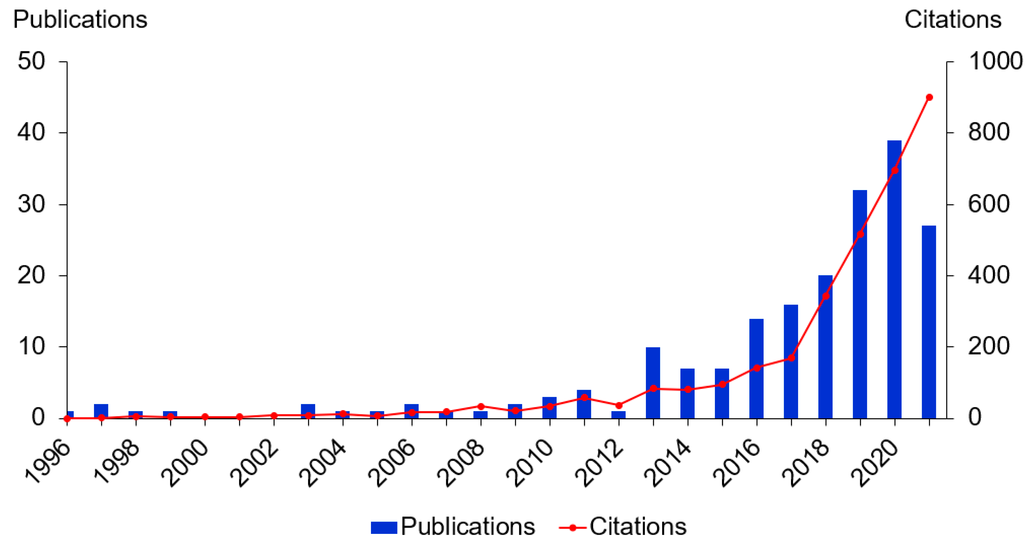
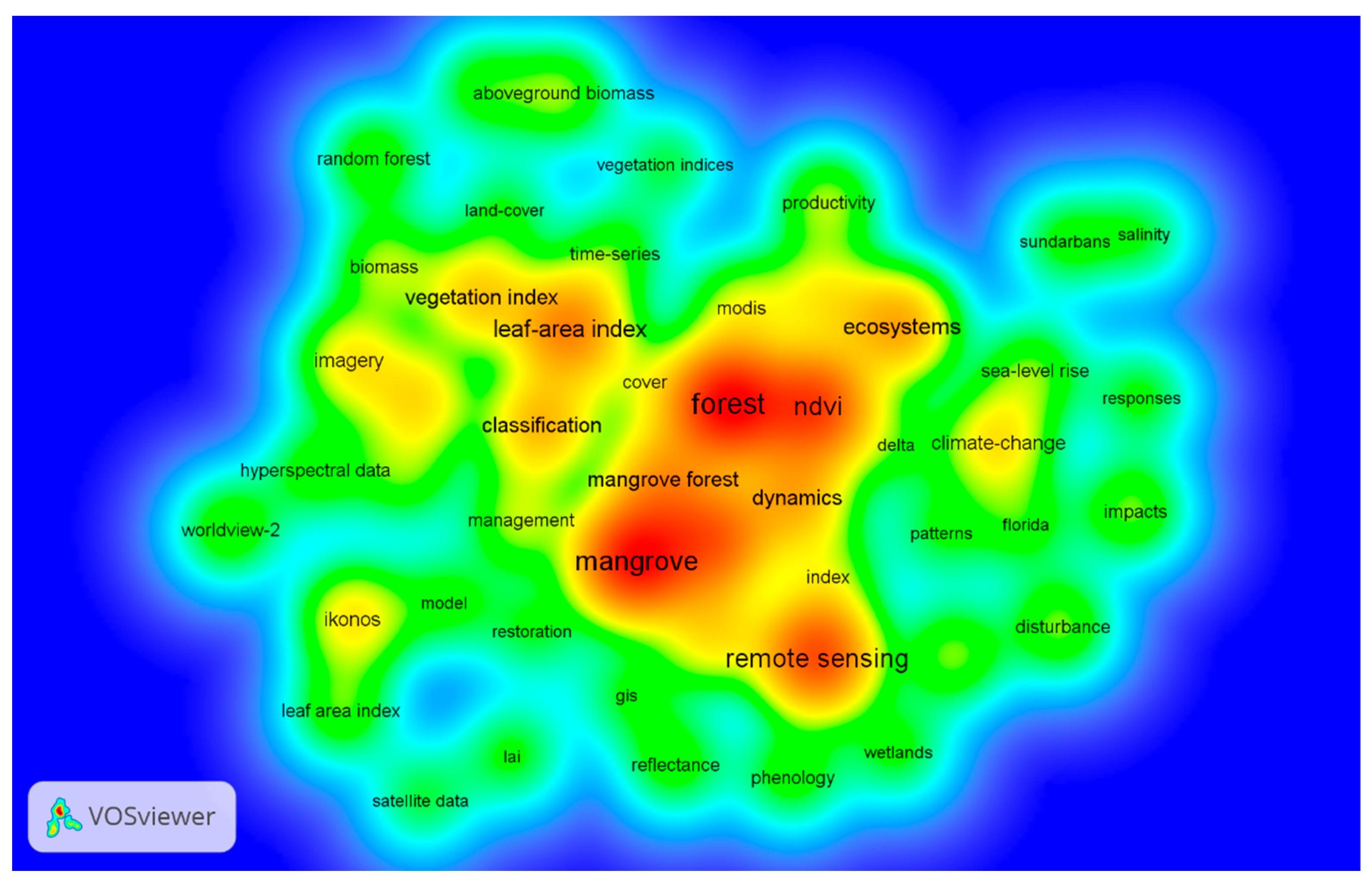
2. Search Strategy and Data Analysis
3. Overview of Spectral Indices Used in Mangrove Remote Sensing
3.1. Spectral Indices with Visible and Near-Infrared Bands (VNIR)
3.2. Spectral Indices in Visible and Red-Edge Bands
3.3. Spectral Indices with Visible Bands of Airborne Systems
3.4. Mangrove-Specific Spectral Indices
4. Evaluation of Spectral Indices Applications in Mangrove Remote Sensing
4.1. Mangrove Extent and Distribution
4.2. Above-Ground Properties of Mangroves Estimation
4.3. Mangrove Changes
5. Discussion and Future Directions
5.1. The Potential Indices for Mangrove Remote Sensing
5.2. Long-Term Mangrove Monitoring with Time Series-Based Approaches in Relation to Driving Factors
5.3. Fusion of Images from Multiple Sensors
6. Conclusions
Author Contributions
Funding
Data Availability Statement
Acknowledgments
Conflicts of Interest
Acronyms
| EVI | Enhanced Vegetation Index |
| LAI | Leaf Area Index |
| NDVI | Normalised Difference Vegetation Index |
| PVI | Perpendicular Vegetation Index |
| RVI | Ratio Vegetation Index |
| SAVI | Soil Adjusted Vegetation Index |
| TSAVI | Transformed Soil Adjusted Vegetation Index |
| TVI | Triangular Vegetation Index |
| VIN | Vegetation Index Number |
References
- Tomlinson, P.B. The Botany of Mangroves; Cambridge University Press: Cambridge, UK, 2016; ISBN 1-316-79065-7. [Google Scholar]
- Mandal, R.N.; Bar, R. Mangroves for Building Resilience to Climate Change; Apple Academic Press: Waretown, NJ, USA, 2018; ISBN 0-429-48778-9. [Google Scholar]
- Cavanaugh, K.C.; Osland, M.J.; Bardou, R.; Hinojosa-Arango, G.; López-Vivas, J.M.; Parker, J.D.; Rovai, A.S. Sensitivity of Mangrove Range Limits to Climate Variability. Glob. Ecol. Biogeogr. 2018, 27, 925–935. [Google Scholar] [CrossRef]
- Ellison, A.M.; Farnsworth, E.J.; Merkt, R.E. Origins of Mangrove Ecosystems and the Mangrove Biodiversity Anomaly. Glob. Ecol. Biogeogr. 1999, 8, 95–115. [Google Scholar]
- Steenis, C.G.G.J. The Distribution of Mangrove Plant Genera and Its Significance for Palaeogeography. Proc. Kon. Net. Amst. 1962, 65, 164–169. [Google Scholar]
- Friess, D.A.; Rogers, K.; Lovelock, C.E.; Krauss, K.W.; Hamilton, S.E.; Lee, S.Y.; Lucas, R.; Primavera, J.; Rajkaran, A.; Shi, S. The State of the World’s Mangrove Forests: Past, Present, and Future. Annu. Rev. Environ. Resour. 2019, 44, 89–115. [Google Scholar] [CrossRef]
- Simard, M.; Fatoyinbo, L.; Smetanka, C.; Rivera-Monroy, V.H.; Castañeda-Moya, E.; Thomas, N.; Van der Stocken, T. Mangrove Canopy Height Globally Related to Precipitation, Temperature and Cyclone Frequency. Nat. Geosci 2019, 12, 40–45. [Google Scholar] [CrossRef]
- Kauffman, J.B.; Adame, M.F.; Arifanti, V.B.; Schile-Beers, L.M.; Bernardino, A.F.; Bhomia, R.K.; Donato, D.C.; Feller, I.C.; Ferreira, T.O.; del Carmen Jesus Garcia, M.; et al. Total Ecosystem Carbon Stocks of Mangroves across Broad Global Environmental and Physical Gradients. Ecol. Monogr. 2020, 90, e01405. [Google Scholar] [CrossRef]
- Sandilyan, S.; Kathiresan, K. Mangrove Conservation: A Global Perspective. Biodivers. Conserv. 2012, 21, 3523–3542. [Google Scholar] [CrossRef]
- FAO of the UN. The World’s Mangroves 1980–2005: A Thematic Study Prepared in the Framework of the Global Forest Resources Assessment 2005; FAO: Rome, Italy, 2007; p. 153. [Google Scholar]
- Bunting, P.; Rosenqvist, A.; Lucas, R.; Rebelo, L.-M.; Hilarides, L.; Thomas, N.; Hardy, A.; Itoh, T.; Shimada, M.; Finlayson, C. The Global Mangrove Watch—A New 2010 Global Baseline of Mangrove Extent. Remote Sens. 2018, 10, 1669. [Google Scholar] [CrossRef]
- Bunting, P.; Rosenqvist, A.; Hilarides, L.; Lucas, R.M.; Thomas, N. Global Mangrove Watch: Updated 2010 Mangrove Forest Extent (v2. 5). Remote Sens. 2022, 14, 1034. [Google Scholar] [CrossRef]
- Kuenzer, C.; Bluemel, A.; Gebhardt, S.; Quoc, T.V.; Dech, S. Remote Sensing of Mangrove Ecosystems: A Review. Remote Sens. 2011, 3, 878–928. [Google Scholar] [CrossRef]
- Lee, S.Y.; Primavera, J.H.; Dahdouh-Guebas, F.; McKee, K.; Bosire, J.O.; Cannicci, S.; Diele, K.; Fromard, F.; Koedam, N.; Marchand, C. Ecological Role and Services of Tropical Mangrove Ecosystems: A Reassessment. Glob. Ecol. Biogeogr. 2014, 23, 726–743. [Google Scholar] [CrossRef]
- Duke, N.; Nagelkerken, I.; Agardy, T.; Wells, S.; Van Lavieren, H. The Importance of Mangroves to People: A Call to Action; United Nations Environment Programme World Conservation Monitoring Centre: Cambridge, UK, 2014; ISBN 92-807-3397-4. [Google Scholar]
- Narayan, S.; Beck, M.W.; Reguero, B.G.; Losada, I.J.; Van Wesenbeeck, B.; Pontee, N.; Sanchirico, J.N.; Ingram, J.C.; Lange, G.-M.; Burks-Copes, K.A. The Effectiveness, Costs and Coastal Protection Benefits of Natural and Nature-Based Defences. PLoS ONE 2016, 11, e0154735. [Google Scholar] [CrossRef]
- Primavera, J.H. Overcoming the Impacts of Aquaculture on the Coastal Zone. Ocean Coast. Manag. 2006, 49, 531–545. [Google Scholar] [CrossRef]
- Donato, D.C.; Kauffman, J.B.; Mackenzie, R.A.; Ainsworth, A.; Pfleeger, A.Z. Whole-Island Carbon Stocks in the Tropical Pacific: Implications for Mangrove Conservation and Upland Restoration. J. Environ. Manag. 2012, 97, 89–96. [Google Scholar] [CrossRef] [PubMed]
- Donato, D.C.; Kauffman, J.B.; Murdiyarso, D.; Kurnianto, S.; Stidham, M.; Kanninen, M. Mangroves among the Most Carbon-Rich Forests in the Tropics. Nat. Geosci. 2011, 4, 293–297. [Google Scholar] [CrossRef]
- Spalding, M.; Parrett, C.L. Global Patterns in Mangrove Recreation and Tourism. Mar. Policy 2019, 110, 103540. [Google Scholar] [CrossRef]
- Giri, C.; Ochieng, E.; Tieszen, L.L.; Zhu, Z.; Singh, A.; Loveland, T.; Masek, J.; Duke, N. Status and Distribution of Mangrove Forests of the World Using Earth Observation Satellite Data. Glob. Ecol. Biogeogr. 2011, 20, 154–159. [Google Scholar] [CrossRef]
- Carugati, L.; Gatto, B.; Rastelli, E.; Lo Martire, M.; Coral, C.; Greco, S.; Danovaro, R. Impact of Mangrove Forests Degradation on Biodiversity and Ecosystem Functioning. Sci. Rep. 2018, 8, 13298. [Google Scholar] [CrossRef]
- Goldberg, L.; Lagomasino, D.; Thomas, N.; Fatoyinbo, T. Global Declines in Human-Driven Mangrove Loss. Glob. Change Biol. 2020, 26, 5844–5855. [Google Scholar] [CrossRef]
- Su, J.; Friess, D.A.; Gasparatos, A. A Meta-Analysis of the Ecological and Economic Outcomes of Mangrove Restoration. Nat. Commun. 2021, 12, 5050. [Google Scholar] [CrossRef]
- Wang, L.; Jia, M.; Yin, D.; Tian, J. A Review of Remote Sensing for Mangrove Forests: 1956–2018. Remote Sens. Environ. 2019, 231, 111223. [Google Scholar] [CrossRef]
- Pham, T.D.; Yokoya, N.; Bui, D.T.; Yoshino, K.; Friess, D.A. Remote Sensing Approaches for Monitoring Mangrove Species, Structure, and Biomass: Opportunities and Challenges. Remote Sens. 2019, 11, 230. [Google Scholar] [CrossRef]
- Maurya, K.; Mahajan, S.; Chaube, N. Remote Sensing Techniques: Mapping and Monitoring of Mangrove Ecosystem—A Review. Complex Intell. Syst. 2021, 7, 2797–2818. [Google Scholar] [CrossRef]
- Cardenas, N.Y.; Joyce, K.E.; Maier, S.W. Monitoring Mangrove Forests: Are We Taking Full Advantage of Technology? Int. J. Appl. Earth Obs. Geoinf. 2017, 63, 1–14. [Google Scholar]
- Campbell, J.B.; Wynne, R.H. Introduction to Remote Sensing; Guilford Press: New York, NY, USA, 2011; ISBN 1-60918-177-8. [Google Scholar]
- Thakur, S.; Mondal, I.; Ghosh, P.B.; Das, P.; De, T.K. A Review of the Application of Multispectral Remote Sensing in the Study of Mangrove Ecosystems with Special Emphasis on Image Processing Techniques. Spat. Inf. Res. 2020, 28, 39–51. [Google Scholar] [CrossRef]
- Zulfa, A.W.; Norizah, K.; Hamdan, O.; Faridah-Hanum, I.; Rhyma, P.P.; Fitrianto, A. Spectral Signature Analysis to Determine Mangrove Species Delineation Structured by Anthropogenic Effects. Ecol. Indic. 2021, 130, 108148. [Google Scholar] [CrossRef]
- Zulfa, A.W.; Norizah, K.; Hamdan, O.; Zulkifly, S.; Faridah-Hanum, I.; Rhyma, P.P. Discriminating Trees Species from the Relationship between Spectral Reflectance and Chlorophyll Contents of Mangrove Forest in Malaysia. Ecol. Indic. 2020, 111, 106024. [Google Scholar] [CrossRef]
- Green, E.P.; Clark, C.D.; Mumby, P.J.; Edwards, A.J.; Ellis, A.C. Remote Sensing Techniques for Mangrove Mapping. Int. J. Remote Sens. 1998, 19, 935–956. [Google Scholar] [CrossRef]
- Heumann, B.W. Satellite Remote Sensing of Mangrove Forests: Recent Advances and Future Opportunities. Prog. Phys. Geogr. 2011, 35, 87–108. [Google Scholar] [CrossRef]
- Purnamasayangsukasih, P.R.; Norizah, K.; Ismail, A.A.; Shamsudin, I. A Review of Uses of Satellite Imagery in Monitoring Mangrove Forests. In Proceedings of the IOP Conference Series: Earth and Environmental Science; IOP Publishing: Bristol, UK, 2016; Volume 37, p. 012034. [Google Scholar]
- Estes, J.; Kline, K.; Collins, E. Remote Sensing. In International Encyclopedia of the Social & Behavioral Sciences; Smelser, N.J., Baltes, P.B., Eds.; Pergamon: Oxford, UK, 2001; pp. 13144–13150. ISBN 978-0-08-043076-8. [Google Scholar]
- Pricope, N.G.; Mapes, K.L.; Woodward, K.D. Remote Sensing of Human–Environment Interactions in Global Change Research: A Review of Advances, Challenges and Future Directions. Remote Sens. 2019, 11, 2783. [Google Scholar] [CrossRef]
- Aria, M.; Cuccurullo, C. Bibliometrix: An R-Tool for Comprehensive Science Mapping Analysis. J. Informetr. 2017, 11, 959–975. [Google Scholar] [CrossRef]
- Derviş, H. Bibliometric Analysis Using Bibliometrix an R Package. J. Scientometr. Res. 2019, 8, 156–160. [Google Scholar] [CrossRef]
- Aria, M.; Misuraca, M.; Spano, M. Mapping the Evolution of Social Research and Data Science on 30 Years of Social Indicators Research. Soc. Indic. Res. 2020, 149, 803–831. [Google Scholar] [CrossRef]
- Duan, P.; Wang, Y.; Yin, P. Remote Sensing Applications in Monitoring of Protected Areas: A Bibliometric Analysis. Remote Sens. 2020, 12, 772. [Google Scholar] [CrossRef]
- Pranckutė, R. Web of Science (WoS) and Scopus: The Titans of Bibliographic Information in Today’s Academic World. Publications 2021, 9, 12. [Google Scholar] [CrossRef]
- Zhu, J.; Liu, W. A Tale of Two Databases: The Use of Web of Science and Scopus in Academic Papers. Scientometrics 2020, 123, 321–335. [Google Scholar] [CrossRef]
- Aghaei Chadegani, A.; Salehi, H.; Yunus, M.; Farhadi, H.; Fooladi, M.; Farhadi, M.; Ale Ebrahim, N. A Comparison between Two Main Academic Literature Collections: Web of Science and Scopus Databases; Social Science Research Network: Rochester, NY, USA, 2013. [Google Scholar]
- Moral-Muñoz, J.A.; Herrera-Viedma, E.; Santisteban-Espejo, A.; Cobo, M.J. Software Tools for Conducting Bibliometric Analysis in Science: An up-to-Date Review. Prof. Inf. 2020, 29, e290103. [Google Scholar] [CrossRef]
- Clarivate, A. Web of Science Journal Evaluation Process and Selection Criteria. Available online: https://clarivate.com/webofsciencegroup/journal-evaluation-process-and-selection-criteria/ (accessed on 7 February 2022).
- Shu, F. Research on the Application of Thomson Data Analyzer to Analyses the Patent Intelligence of Scientific Institutions. Inf. Sci. 2008, 26, 1833–1843. [Google Scholar]
- Perianes-Rodriguez, A.; Waltman, L.; van Eck, N.J. Constructing Bibliometric Networks: A Comparison between Full and Fractional Counting. J. Informetr. 2016, 10, 1178–1195. [Google Scholar] [CrossRef]
- Liu, W. The Data Source of This Study Is Web of Science Core Collection? Not Enough. Scientometrics 2019, 121, 1815–1824. [Google Scholar] [CrossRef]
- Bannari, A.; Morin, D.; Bonn, F.; Huete, A.R. A Review of Vegetation Indices. Remote Sens. Rev. 1995, 13, 95–120. [Google Scholar] [CrossRef]
- Raynaud, M.; Goutaudier, V.; Louis, K.; Al-Awadhi, S.; Dubourg, Q.; Truchot, A.; Brousse, R.; Saleh, N.; Giarraputo, A.; Debiais, C.; et al. Impact of the COVID-19 Pandemic on Publication Dynamics and Non-COVID-19 Research Production. BMC Med. Res. Methodol. 2021, 21, 255. [Google Scholar] [CrossRef] [PubMed]
- Vinay, V.; Julia, L. Introducing the Spectral Index Library in ArcGIS. Available online: https://www.esri.com/about/newsroom/arcuser/spectral-library/ (accessed on 6 February 2022).
- Xue, J.; Su, B. Significant Remote Sensing Vegetation Indices: A Review of Developments and Applications. J. Sens. 2017, 2017, 1353691. [Google Scholar] [CrossRef]
- Deng, Y.; Wu, C.; Li, M.; Chen, R. RNDSI: A Ratio Normalized Difference Soil Index for Remote Sensing of Urban/Suburban Environments. Int. J. Appl. Earth Obs. Geoinf. 2015, 39, 40–48. [Google Scholar] [CrossRef]
- Baloloy, A.B.; Blanco, A.C.; Sta, A.R.R.C.; Nadaoka, K. Development and Application of a New Mangrove Vegetation Index (MVI) for Rapid and Accurate Mangrove Mapping. ISPRS J. Photogramm. Remote Sens. 2020, 166, 95–117. [Google Scholar] [CrossRef]
- Winarso, G.; Purwanto, A.; Yuwono, D.; Center, R.S.A. New Mangrove Index as Degradation Health Indicator Using Remote Sensing Data: Segara Anakan and Alas Purwo Case Study. In Proceedings of the 12th Biennial Conference of Pan Ocean Remote Sensing Conference (PORSEC 2014), Bali, Indonesia, 4–7 November 2014; pp. 4–7. [Google Scholar]
- Zhang, X.; Tian, Q. A Mangrove Recognition Index for Remote Sensing of Mangrove Forest from Space. Curr. Sci. 2013, 105, 1149–1154. [Google Scholar]
- Gupta, K.; Mukhopadhyay, A.; Giri, S.; Chanda, A.; Majumdar, S.D.; Samanta, S.; Mitra, D.; Samal, R.N.; Pattnaik, A.K.; Hazra, S. An Index for Discrimination of Mangroves from Non-Mangroves Using LANDSAT 8 OLI Imagery. MethodsX 2018, 5, 1129–1139. [Google Scholar] [CrossRef]
- Kumar, A.; Stupp, P.; Dahal, S.; Remillard, C.; Bledsoe, R.; Stone, A.; Cameron, C.; Rastogi, G.; Samal, R.; Mishra, D.R. A Multi-Sensor Approach for Assessing Mangrove Biophysical Characteristics in Coastal Odisha, India. Proc. Natl. Acad. Sci. USA India Sect. A Phys. Sci. 2017, 87, 679–700. [Google Scholar] [CrossRef]
- Jia, M.; Wang, Z.; Wang, C.; Mao, D.; Zhang, Y. A New Vegetation Index to Detect Periodically Submerged Mangrove Forest Using Single-Tide Sentinel-2 Imagery. Remote Sens. 2019, 11, 2043. [Google Scholar] [CrossRef]
- McFeeters, S.K. The Use of the Normalized Difference Water Index (NDWI) in the Delineation of Open Water Features. Int. J. Remote Sens. 1996, 17, 1425–1432. [Google Scholar] [CrossRef]
- Pearson, R.L.; Miller, L.D. Remote Mapping of Standing Crop Biomass for Estimation of the Productivity of the Shortgrass Prairie. Remote Sens. Environ. 1972, 8, 1355–1379. [Google Scholar]
- Rouse, J.W.; Haas, R.H.; Schell, J.A.; Deering, D.W. Monitoring Vegetation Systems in the Great Plains with ERTS. In Third Earth Reserves Technology Satellite Symposium; Greenbelt: NASA SP-351; NASA: Washington, DC, USA, 1973; Volume 30103017, pp. 309–317. [Google Scholar]
- Huang, S.; Tang, L.; Hupy, J.P.; Wang, Y.; Shao, G. A Commentary Review on the Use of Normalized Difference Vegetation Index (NDVI) in the Era of Popular Remote Sensing. J. For. Res. 2021, 32, 1–6. [Google Scholar] [CrossRef]
- Jensen, J.R.; Lin, H.; Yang, X.; Ramsey, E., III; Davis, B.A.; Thoemke, C.W. The Measurement of Mangrove Characteristics in Southwest Florida Using SPOT Multispectral Data. Geocarto Int. 1991, 6, 13–21. [Google Scholar] [CrossRef]
- Forkel, M.; Carvalhais, N.; Verbesselt, J.; Mahecha, M.D.; Neigh, C.S.R.; Reichstein, M. Trend Change Detection in NDVI Time Series: Effects of Inter-Annual Variability and Methodology. Remote Sens. 2013, 5, 2113–2144. [Google Scholar] [CrossRef]
- Huete, A.R. A Soil-Adjusted Vegetation Index (SAVI). Remote Sens. Environ. 1988, 25, 295–309. [Google Scholar] [CrossRef]
- Baret, F.; Guyot, G.; Major, D.J. TSAVI: A Vegetation Index Which Minimizes Soil Brightness Effects on LAI and APAR Estimation. In Proceedings of the 12th Canadian Symposium on Remote Sensing Geoscience and Remote Sensing Symposium, Vancouver, BC, Canada, 10–14 July 1989; Volume 3, pp. 1355–1358. [Google Scholar]
- Huete, A.; Didan, K.; Miura, T.; Rodriguez, E.P.; Gao, X.; Ferreira, L.G. Overview of the Radiometric and Biophysical Performance of the MODIS Vegetation Indices. Remote Sens. Environ. 2002, 83, 195–213. [Google Scholar] [CrossRef]
- Tran, T.V.; Tran, D.X.; Nguyen, H.; Latorre-Carmona, P.; Myint, S.W. Characterising Spatiotemporal Vegetation Variations Using LANDSAT Time-Series and Hurst Exponent Index in the Mekong River Delta. Land Degrad. Dev. 2021, 32, 3507–3523. [Google Scholar] [CrossRef]
- Jiang, Z.; Huete, A.R.; Didan, K.; Miura, T. Development of a Two-Band Enhanced Vegetation Index without a Blue Band. Remote Sens. Environ. 2008, 112, 3833–3845. [Google Scholar] [CrossRef]
- Liu, H.Q.; Huete, A. A Feedback Based Modification of the NDVI to Minimize Canopy Background and Atmospheric Noise. IEEE Trans. Geosci. Remote Sens. 1995, 33, 457–465. [Google Scholar] [CrossRef]
- Richardson, A.J.; Wiegand, C.L. Distinguishing Vegetation from Soil Background Information. Photogramm. Eng. Remote Sens. 1977, 43, 1541–1552. [Google Scholar]
- Wicaksono, P.; Danoedoro, P.; Hartono; Nehren, U. Mangrove Biomass Carbon Stock Mapping of the Karimunjawa Islands Using Multispectral Remote Sensing. Int. J. Remote Sens. 2015, 37, 26–52. [Google Scholar] [CrossRef]
- Wicaksono, P. Mangrove Above-Ground Carbon Stock Mapping of Multi-Resolution Passive Remote-Sensing Systems. Int. J. Remote Sens. 2017, 38, 1551–1578. [Google Scholar] [CrossRef]
- Díaz, B.M.; Blackburn, G.A. Remote Sensing of Mangrove Biophysical Properties: Evidence from a Laboratory Simulation of the Possible Effects of Background Variation on Spectral Vegetation Indices. Int. J. Remote Sens. 2003, 24, 53–73. [Google Scholar] [CrossRef]
- Kovacs, J.M.; Flores-Verdugo, F.; Wang, J.; Aspden, L.P. Estimating Leaf Area Index of a Degraded Mangrove Forest Using High Spatial Resolution Satellite Data. Aquat. Bot. 2004, 80, 13–22. [Google Scholar] [CrossRef]
- Kovacs, J.M.; King, J.M.L.; Flores de Santiago, F.; Flores-Verdugo, F. Evaluating the Condition of a Mangrove Forest of the Mexican Pacific Based on an Estimated Leaf Area Index Mapping Approach. Environ. Monit Assess 2009, 157, 137–149. [Google Scholar] [CrossRef]
- Kovacs, J.M.; Liu, Y.; Zhang, C.; Flores-Verdugo, F.; de Santiago, F.F. A Field Based Statistical Approach for Validating a Remotely Sensed Mangrove Forest Classification Scheme. Wetl. Ecol. Manag. 2011, 19, 409. [Google Scholar] [CrossRef]
- Kamal, M.; Phinn, S.; Johansen, K. Assessment of Multi-Resolution Image Data for Mangrove Leaf Area Index Mapping. Remote Sens. Environ. 2016, 176, 242–254. [Google Scholar] [CrossRef]
- Heenkenda, M.K.; Maier, S.W.; Joyce, K.E. Estimating Mangrove Biophysical Variables Using WorldView-2 Satellite Data: Rapid Creek, Northern Territory, Australia. J. Imaging 2016, 2, 24. [Google Scholar] [CrossRef]
- Zhu, Y.; Liu, K.; Liu, L.; Myint, S.W.; Wang, S.; Liu, H.; He, Z. Exploring the Potential of WorldView-2 Red-Edge Band-Based Vegetation Indices for Estimation of Mangrove Leaf Area Index with Machine Learning Algorithms. Remote Sens. 2017, 9, 1060. [Google Scholar] [CrossRef]
- George, R.; Padalia, H.; Sinha, S.K.; Kumar, A.S. Evaluation of the Use of Hyperspectral Vegetation Indices for Estimating Mangrove Leaf Area Index in Middle Andaman Island, India. Remote Sens. Lett. 2018, 9, 1099–1108. [Google Scholar] [CrossRef]
- Wicaksono, P.; Hafizt, M. Dark Target Effectiveness for Dark-Object Subtraction Atmospheric Correction Method on Mangrove above-Ground Carbon Stock Mapping. IET Image Processing 2018, 12, 582–587. [Google Scholar] [CrossRef]
- Muhsoni, F.F.; Sambah, A.B.; Mahmudi, M.; Wiadnya, D.G.R. Estimation of Mangrove Carbon Stock with Hybrid Method Using Image Sentinel-2. GEOMATE J. 2018, 15, 185–192. [Google Scholar] [CrossRef]
- Oostdijk, M.; Santos, M.J.; Whigham, D.; Verhoeven, J.; Silvestri, S. Assessing Rehabilitation of Managed Mangrove Ecosystems Using High Resolution Remote Sensing. Estuar. Coast. Shelf Sci. 2018, 211, 238–247. [Google Scholar] [CrossRef]
- Razali, S.M.; Nuruddin, A.A.; Kamarudin, N. Mapping Mangrove Density for Conservation of the RAMSAR Site in Peninsular Malaysia. Int. J. Conserv. Sci. 2020, 11, 153–164. [Google Scholar]
- Ávila-Flores, G.; Juárez-Mancilla, J.; Hinojosa-Arango, G.; Cruz-Chávez, P.; López-Vivas, J.M.; Arizpe-Covarrubias, O. A Practical Index to Estimate Mangrove Conservation Status: The Forests from La Paz Bay, Mexico as a Case Study. Sustainability 2020, 12, 858. [Google Scholar] [CrossRef]
- Pham, T.D.; Yokoya, N.; Xia, J.; Ha, N.T.; Le, N.N.; Nguyen, T.T.T.; Dao, T.H.; Vu, T.T.P.; Pham, T.D.; Takeuchi, W. Comparison of Machine Learning Methods for Estimating Mangrove Above-Ground Biomass Using Multiple Source Remote Sensing Data in the Red River Delta Biosphere Reserve, Vietnam. Remote Sens. 2020, 12, 1334. [Google Scholar] [CrossRef]
- Xia, Q.; Qin, C.-Z.; Li, H.; Huang, C.; Su, F.-Z.; Jia, M.-M. Evaluation of Submerged Mangrove Recognition Index Using Multi-Tidal Remote Sensing Data. Ecol. Indic. 2020, 113, 106196. [Google Scholar] [CrossRef]
- Ali, A.; Nayyar, Z.A. Extraction of Mangrove Forest through Landsat 8 Mangrove Index (L8MI). Arab. J. Geosci. 2020, 13, 1132. [Google Scholar] [CrossRef]
- Ramsey, E.W.R., III; Jensen, J.R. Remote Sensing of Mangrove Wetlands: Relating Canopy Spectra to Site-Specific Data. Photogramm. Eng. Remote Sens. 1996, 62, 939–948. [Google Scholar]
- Green, E.P.; Mumby, P.J.; Edwards, A.J.; Clark, C.D.; Ellis, A.C. Estimating Leaf Area Index of Mangroves from Satellite Data. Aquat. Bot. 1997, 58, 11–19. [Google Scholar] [CrossRef]
- Green, E.; Mumby, P.; Edwards, A.; Clark, C.; Ellis, A. The Assessment of Mangrove Areas Using High Resolution Multispectral Airborne Imagery. J. Coast. Res. 1998, 14, 433–443. [Google Scholar]
- Ruiz-Luna, A.; Berlanga-Robles, C. Modifications in Coverage Patterns and Land Use around the Huizache-Caimanero Lagoon System, Sinaloa, Mexico: A Multi-Temporal Analysis Using LANDSAT Images. Estuar. Coast. Shelf Sci. 1999, 49, 37–44. [Google Scholar] [CrossRef]
- Kovacs, J.M.; Wang, J.; Flores-Verdugo, F. Mapping Mangrove Leaf Area Index at the Species Level Using IKONOS and LAI-2000 Sensors for the Agua Brava Lagoon, Mexican Pacific. Estuar. Coast. Shelf Sci. 2005, 62, 377–384. [Google Scholar] [CrossRef]
- Mantri, V.A.; Mishra, A.K. On Monitoring Mangrove Vegetation of Sagar Island by Remote Sensing. Natl. Acad. Sci. Lett. 2006, 29, 45–48. [Google Scholar] [CrossRef]
- Nichol, C.J.; Rascher, U.; Matsubara, S.; Osmond, B. Assessing Photosynthetic Efficiency in an Experimental Mangrove Canopy Using Remote Sensing and Chlorophyll Fluorescence. Trees 2005, 20, 9. [Google Scholar] [CrossRef]
- Li, X.; Gar-On Yeh, A.; Wang, S.; Liu, K.; Liu, X.; Qian, J.; Chen, X. Regression and Analytical Models for Estimating Mangrove Wetland Biomass in South China Using Radarsat Images. Int. J. Remote Sens. 2007, 28, 5567–5582. [Google Scholar] [CrossRef]
- Kovacs, J.M.; Zhang, C.; Flores-Verdugo, F.J. Mapping the Condition of Mangroves of the Mexican Pacific Using C-Band ENVISAT ASAR and Landsat Optical Data. Cienc. Mar. 2008, 34, 407–418. [Google Scholar] [CrossRef]
- Lee, T.-M.; Yeh, H.-C. Applying Remote Sensing Techniques to Monitor Shifting Wetland Vegetation: A Case Study of Danshui River Estuary Mangrove Communities, Taiwan. Ecol. Eng. 2009, 35, 487–496. [Google Scholar] [CrossRef]
- Rajitha, K.; Mukherjee, C.K.; Vinu Chandran, R.; Prakash Mohan, M.M. Land-Cover Change Dynamics and Coastal Aquaculture Development: A Case Study in the East Godavari Delta, Andhra Pradesh, India Using Multi-Temporal Satellite Data. Int. J. Remote Sens. 2010, 31, 4423–4442. [Google Scholar] [CrossRef]
- Ruiz-Luna, A.; Cervantes Escobar, A.; Berlanga-Robles, C. Assessing Distribution Patterns, Extent, and Current Condition of Northwest Mexico Mangroves. Wetlands 2010, 30, 717–723. [Google Scholar] [CrossRef]
- Satyanarayana, B.; Mohamad, K.A.; Idris, I.F.; Husain, M.-L.; Dahdouh-Guebas, F. Assessment of Mangrove Vegetation Based on Remote Sensing and Ground-Truth Measurements at Tumpat, Kelantan Delta, East Coast of Peninsular Malaysia. Int. J. Remote Sens. 2011, 32, 1635–1650. [Google Scholar] [CrossRef]
- Kamthonkiat, D.; Rodfai, C.; Saiwanrungkul, A.; Koshimura, S.; Matsuoka, M. Geoinformatics in Mangrove Monitoring: Damage and Recovery after the 2004 Indian Ocean Tsunami in Phang Nga, Thailand. Nat. Hazards Earth Syst. Sci. 2011, 11, 1851–1862. [Google Scholar] [CrossRef]
- Pujiono, E.; Kwak, D.-A.; Lee, W.-K.; Sulistyanto; Kim, S.-R.; Lee, J.Y.; Lee, S.-H.; Park, T.; Kim, M.-I. RGB-NDVI Color Composites for Monitoring the Change in Mangrove Area at the Maubesi Nature Reserve, Indonesia. For. Sci. Technol. 2013, 9, 171–179. [Google Scholar] [CrossRef]
- Vo, Q.T.; Oppelt, N.; Leinenkugel, P.; Kuenzer, C. Remote Sensing in Mapping Mangrove Ecosystems—An Object-Based Approach. Remote Sens. 2013, 5, 183–201. [Google Scholar] [CrossRef]
- Wong, F.K.K.; Fung, T. Combining Hyperspectral and Radar Imagery for Mangrove Leaf Area Index Modeling. Photogramm. Eng. Remote Sens. 2013, 79, 479–490. [Google Scholar] [CrossRef]
- Manna, S.; Mondal, P.P.; Mukhopadhyay, A.; Akhand, A.; Hazra, S.; Mitra, D. Vegetation Cover Change Analysis from Multi-Temporal Satellite Data in Jharkhali Island, Sundarbans, India. IJMS 2013, 42, 331–342. [Google Scholar]
- Hamdan, O.; Khairunnisa, M.; Ammar, A.; Hasmadi, I.M.; Aziz, H.K. Mangrove Carbon Stock Assessment by Optical Satellite Imagery. J. Trop. For. Sci. 2013, 25, 554–565. [Google Scholar]
- Wohlfart, C.; Wegmann, M.; Leimgruber, P. Mapping Threatened Dry Deciduous Dipterocarp Forest in South-East Asia for Conservation Management. Trop. Conserv. Sci. 2014, 7, 597–613. [Google Scholar] [CrossRef]
- Almeida, P.; Altobelli, A.; D’Aietti, L.; Feoli, E.; Ganis, P.; Giordano, F.; Napolitano, R.; Simonetti, C. The Role of Vegetation Analysis by Remote Sensing and GIS Technology for Planning Sustainable Development: A Case Study for the Santos Estuary Drainage Basin (Brazil). Plant Biosyst.-Int. J. Deal. All Asp. Plant Biol. 2014, 148, 540–546. [Google Scholar] [CrossRef]
- Fuller, D.; Wang, Y. Recent Trends in Satellite Vegetation Index Observations Indicate Decreasing Vegetation Biomass in the Southeastern Saline Everglades Wetlands. Wetlands 2014, 34, 67–77. [Google Scholar] [CrossRef]
- Chellamani, P.; Singh, C.P.; Panigrahy, S. Assessment of the Health Status of Indian Mangrove Ecosystems Using Multi Temporal Remote Sensing Data. Trop. Ecol. 2014, 55, 245–253. [Google Scholar]
- Manna, S.; Nandy, S.; Chanda, A.; Akhand, A.; Hazra, S.; Dadhwal, V.K. Estimating Aboveground Biomass in Avicennia Marina Plantation in Indian Sundarbans Using High-Resolution Satellite Data. J. Appl. Remote Sens. 2014, 8, 083638. [Google Scholar] [CrossRef]
- Anwar, M.S.; Takewaka, S. Analyses on Phenological and Morphological Variations of Mangrove Forests along the Southwest Coast of Bangladesh. J. Coast. Conserv. 2014, 18, 339–357. [Google Scholar] [CrossRef]
- Patil, V.; Singh, A.; Naik, N.; Unnikrishnan, S. Estimation of Mangrove Carbon Stocks by Applying Remote Sensing and GIS Techniques. Wetlands 2015, 35, 695–707. [Google Scholar] [CrossRef]
- Ibharim, N.A.; Mustapha, M.A.; Lihan, T.; Mazlan, A.G. Mapping Mangrove Changes in the Matang Mangrove Forest Using Multi Temporal Satellite Imageries. Ocean Coast. Manag. 2015, 114, 64–76. [Google Scholar] [CrossRef]
- Heenkenda, M.K.; Joyce, K.E.; Maier, S.W.; de Bruin, S. Quantifying Mangrove Chlorophyll from High Spatial Resolution Imagery. ISPRS J. Photogramm. Remote Sens. 2015, 108, 234–244. [Google Scholar] [CrossRef]
- Lagomasino, D.; Price, R.M.; Whitman, D.; Melesse, A.; Oberbauer, S.F. Spatial and Temporal Variability in Spectral-Based Surface Energy Evapotranspiration Measured from Landsat 5TM across Two Mangrove Ecotones. Agric. For. Meteorol. 2015, 213, 304–316. [Google Scholar] [CrossRef]
- Alatorre, L.C.; Sánchez-Carrillo, S.; Miramontes-Beltrán, S.; Medina, R.J.; Torres-Olave, M.E.; Bravo, L.C.; Wiebe, L.C.; Granados, A.; Adams, D.K.; Sánchez, E.; et al. Temporal Changes of NDVI for Qualitative Environmental Assessment of Mangroves: Shrimp Farming Impact on the Health Decline of the Arid Mangroves in the Gulf of California (1990–2010). J. Arid Environ. 2016, 125, 98–109. [Google Scholar] [CrossRef]
- Jana, A.; Maiti, S.; Biswas, A. Seasonal Change Monitoring and Mapping of Coastal Vegetation Types along Midnapur-Balasore Coast, Bay of Bengal Using Multi-Temporal Landsat Data. Model. Earth Syst. Environ. 2015, 2, 7. [Google Scholar] [CrossRef]
- Zhang, K.; Thapa, B.; Ross, M.; Gann, D. Remote Sensing of Seasonal Changes and Disturbances in Mangrove Forest: A Case Study from South Florida. Ecosphere 2016, 7, e01366. [Google Scholar] [CrossRef]
- Conti, L.A.; de Araújo, C.A.S.; Cunha-Lignon, M. Spatial Database Modeling for Mangrove Forests Mapping; Example of Two Estuarine Systems in Brazil. Model. Earth Syst. Environ. 2016, 2, 73. [Google Scholar] [CrossRef]
- Rodriguez, W.; Feller, I.C.; Cavanaugh, K.C. Spatio-Temporal Changes of a Mangrove–Saltmarsh Ecotone in the Northeastern Coast of Florida, USA. Glob. Ecol. Conserv. 2016, 7, 245–261. [Google Scholar] [CrossRef]
- Malone, S.L.; Barr, J.; Fuentes, J.D.; Oberbauer, S.F.; Staudhammer, C.L.; Gaiser, E.E.; Starr, G. Sensitivity to Low-Temperature Events: Implications for CO2 Dynamics in Subtropical Coastal Ecosystems. Wetlands 2016, 36, 957–967. [Google Scholar] [CrossRef]
- Nardin, W.; Locatelli, S.; Pasquarella, V.; Rulli, M.C.; Woodcock, C.E.; Fagherazzi, S. Dynamics of a Fringe Mangrove Forest Detected by Landsat Images in the Mekong River Delta, Vietnam. Earth Surf. Process. Landf. 2016, 41, 2024–2037. [Google Scholar] [CrossRef]
- Son, N.-T.; Chen, C.-F.; Chen, C.-R. Mapping Mangrove Density from Rapideye Data in Central America. Open Geosci. 2017, 9, 211–220. [Google Scholar] [CrossRef]
- Yagci, A.L.; Santanello, J.A.; Jones, J.W.; Barr, J. Estimating Evaporative Fraction from Readily Obtainable Variables in Mangrove Forests of the Everglades, U.S.A. Int. J. Remote Sens. 2017, 38, 3981–4007. [Google Scholar] [CrossRef]
- Abd-El Monsef, H.; Smith, S.E. A New Approach for Estimating Mangrove Canopy Cover Using Landsat 8 Imagery. Comput. Electron. Agric. 2017, 135, 183–194. [Google Scholar] [CrossRef]
- Lovelock, C.E.; Feller, I.C.; Reef, R.; Hickey, S.; Ball, M.C. Mangrove Dieback during Fluctuating Sea Levels. Sci. Rep. 2017, 7, 1680. [Google Scholar] [CrossRef]
- Pham, L.T.; Brabyn, L. Monitoring Mangrove Biomass Change in Vietnam Using SPOT Images and an Object-Based Approach Combined with Machine Learning Algorithms. ISPRS J. Photogramm. Remote Sens. 2017, 128, 86–97. [Google Scholar] [CrossRef]
- Tian, J.; Wang, L.; Li, X.; Gong, H.; Shi, C.; Zhong, R.; Liu, X. Comparison of UAV and WorldView-2 Imagery for Mapping Leaf Area Index of Mangrove Forest. Int. J. Appl. Earth Obs. Geoinf. 2017, 61, 22–31. [Google Scholar] [CrossRef]
- Chen, B.; Xiao, X.; Li, X.; Pan, L.; Doughty, R.; Ma, J.; Dong, J.; Qin, Y.; Zhao, B.; Wu, Z. A Mangrove Forest Map of China in 2015: Analysis of Time Series Landsat 7/8 and Sentinel-1A Imagery in Google Earth Engine Cloud Computing Platform. ISPRS J. Photogramm. Remote Sens. 2017, 131, 104–120. [Google Scholar] [CrossRef]
- Zhang, X.; Treitz, P.M.; Chen, D.; Quan, C.; Shi, L.; Li, X. Mapping Mangrove Forests Using Multi-Tidal Remotely-Sensed Data and a Decision-Tree-Based Procedure. Int. J. Appl. Earth Obs. Geoinf. 2017, 62, 201–214. [Google Scholar] [CrossRef]
- Castillo, J.A.A.; Apan, A.A.; Maraseni, T.N.; Salmo, S.G. Estimation and Mapping of Above-Ground Biomass of Mangrove Forests and Their Replacement Land Uses in the Philippines Using Sentinel Imagery. ISPRS J. Photogramm. Remote Sens. 2017, 134, 70–85. [Google Scholar] [CrossRef]
- Galeano, A.; Urrego, L.E.; Botero, V.; Bernal, G. Mangrove Resilience to Climate Extreme Events in a Colombian Caribbean Island. Wetl. Ecol. Manag. 2017, 25, 743–760. [Google Scholar] [CrossRef]
- Milani, A.S. Mangrove Forests of the Persian Gulf and the Gulf of Oman. In Threats to Mangrove Forests: Hazards, Vulnerability, and Management; Makowski, C., Finkl, C.W., Eds.; Coastal Research Library; Springer International Publishing: Cham, Switzerland, 2018; pp. 53–75. ISBN 978-3-319-73016-5. [Google Scholar]
- Muhd-Ekhzarizal, M.; Mohd-Hasmadi, I.; Hamdan, O.; Mohamad-Roslan, M.; Noor-Shaila, S. Estimation of Aboveground Biomass in Mangrove Forests Using Vegetation Indices from SPOT-5 Image. J. Trop. For. Sci. 2018, 30, 224–233. [Google Scholar]
- Valderrama-Landeros, L.; Flores-de-Santiago, F.; Kovacs, J.M.; Flores-Verdugo, F. An Assessment of Commonly Employed Satellite-Based Remote Sensors for Mapping Mangrove Species in Mexico Using an NDVI-Based Classification Scheme. Environ. Monit. Assess 2018, 190, 23. [Google Scholar] [CrossRef]
- Flores-Cárdenas, F.; Millán-Aguilar, O.; Díaz-Lara, L.; Rodríguez-Arredondo, L.; Hurtado-Oliva, M.Á.; Manzano-Sarabia, M. Trends in the Normalized Difference Vegetation Index for Mangrove Areas in Northwestern Mexico. J. Coast. Res. 2018, 34, 877–882. [Google Scholar] [CrossRef]
- Wang, M.; Cao, W.; Guan, Q.; Wu, G.; Wang, F. Assessing Changes of Mangrove Forest in a Coastal Region of Southeast China Using Multi-Temporal Satellite Images. Estuar. Coast. Shelf Sci. 2018, 207, 283–292. [Google Scholar] [CrossRef]
- Marshall, A.; Schulte to Bühne, H.; Bland, L.; Pettorelli, N. Assessing Ecosystem Collapse Risk in Ecosystems Dominated by Foundation Species: The Case of Fringe Mangroves. Ecol. Indic. 2018, 91, 128–137. [Google Scholar] [CrossRef]
- Chen, Y.-C.; Chu, T.-J.; Wei, J.-D.; Shih, C.-H. Effects of Mangrove Removal on Benthic Organisms in the Siangshan Wetland in Hsinchu, Taiwan. PeerJ. 2018, 6, e5670. [Google Scholar] [CrossRef]
- Staben, G.; Lucieer, A.; Scarth, P. Modelling LiDAR Derived Tree Canopy Height from Landsat TM, ETM+ and OLI Satellite Imagery—A Machine Learning Approach. Int. J. Appl. Earth Obs. Geoinf. 2018, 73, 666–681. [Google Scholar] [CrossRef]
- Wan, R.; Wang, P.; Wang, X.; Yao, X.; Dai, X. Modeling Wetland Aboveground Biomass in the Poyang Lake National Nature Reserve Using Machine Learning Algorithms and Landsat-8 Imagery. J. Appl. Remote Sens. 2018, 12, 046029. [Google Scholar] [CrossRef]
- Selvam, P.P.; Ramesh, R.; Purvaja, R.; Srinivasalu, S. Temporal Changes in Mangrove Forest Coverage and Seasonal Influence on NDVI in Pichavaram Mangrove Forest, India. Int. J. Ecol. Dev. 2019, 34, 49–61. [Google Scholar]
- Taureau, F.; Robin, M.; Proisy, C.; Fromard, F.; Imbert, D.; Debaine, F. Mapping the Mangrove Forest Canopy Using Spectral Unmixing of Very High Spatial Resolution Satellite Images. Remote Sens. 2019, 11, 367. [Google Scholar] [CrossRef]
- Shrestha, S.; Miranda, I.; Kumar, A.; Pardo, M.L.E.; Dahal, S.; Rashid, T.; Remillard, C.; Mishra, D.R. Identifying and Forecasting Potential Biophysical Risk Areas within a Tropical Mangrove Ecosystem Using Multi-Sensor Data. Int. J. Appl. Earth Obs. Geoinf. 2019, 74, 281–294. [Google Scholar] [CrossRef]
- Roy, S.; Mahapatra, M.; Chakraborty, A. Mapping and Monitoring of Mangrove along the Odisha Coast Based on Remote Sensing and GIS Techniques. Modeling Earth Syst. Environ. 2019, 5, 217–226. [Google Scholar] [CrossRef]
- Mafi-Gholami, D.; Zenner, E.K.; Jaafari, A.; Ward, R.D. Modeling Multi-Decadal Mangrove Leaf Area Index in Response to Drought along the Semi-Arid Southern Coasts of Iran. Sci. Total Environ. 2019, 656, 1326–1336. [Google Scholar] [CrossRef]
- Bera, R.; Maiti, R. Quantitative Analysis of Erosion and Accretion (1975–2017) Using DSAS—A Study on Indian Sundarbans. Reg. Stud. Mar. Sci. 2019, 28, 100583. [Google Scholar] [CrossRef]
- Alejandro Berlanga-Robles, C.; Ruiz-Luna, A.; Nepita Villanueva, M.R. Seasonal Trend Analysis (STA) of MODIS Vegetation Index Time Series for the Mangrove Canopy of the Teacapan-Agua Brava Lagoon System, Mexico. GIScience Remote Sens. 2019, 56, 338–361. [Google Scholar] [CrossRef]
- Chuai, X.; Yuan, Y.; Zhang, X.; Guo, X.; Zhang, X.; Xie, F.; Zhao, R.; Li, J. Multiangle Land Use-Linked Carbon Balance Examination in Nanjing City, China. Land Use Policy 2019, 84, 305–315. [Google Scholar] [CrossRef]
- Calva, L.G.; Golubov, J.; Mandujano, M.D.C.; Lara-Domínguez, A.L.; López-Portillo, J. Assessing Google Earth Pro Images for Detailed Conservation Diagnostics of Mangrove Communities. Coas 2019, 92, 33–43. [Google Scholar] [CrossRef]
- Zhu, X.; Song, L.; Weng, Q.; Huang, G. Linking in Situ Photochemical Reflectance Index Measurements with Mangrove Carbon Dynamics in a Subtropical Coastal Wetland. J. Geophys. Res. Biogeosci. 2019, 124, 1714–1730. [Google Scholar] [CrossRef]
- Yaney-Keller, A.; Tomillo, P.S.; Marshall, J.M.; Paladino, F.V. Using Unmanned Aerial Systems (UAS) to Assay Mangrove Estuaries on the Pacific Coast of Costa Rica. PLoS ONE 2019, 14, e0217310. [Google Scholar] [CrossRef]
- Santos, R.D.O.; Delgado, R.C.; Pereira, M.G.; de Souza, L.P.; Tedoro, P.E.; da Silva Junior, C.A.; Costa, G.D.O. Space-Time Variability of the Roncador River Basin in the Change of Land Use and Cover and Its Correlation with Climatic Variables. Biosci. J. 2019, 35, 1033–1042. [Google Scholar] [CrossRef]
- Vázquez-Lule, A.; Colditz, R.; Herrera-Silveira, J.; Guevara, M.; Rodríguez-Zúñiga, M.T.; Cruz, I.; Ressl, R.; Vargas, R. Greenness Trends and Carbon Stocks of Mangroves across Mexico. Environ. Res. Lett. 2019, 14, 075010. [Google Scholar] [CrossRef]
- Pandey, P.C.; Anand, A.; Srivastava, P.K. Spatial Distribution of Mangrove Forest Species and Biomass Assessment Using Field Inventory and Earth Observation Hyperspectral Data. Biodivers. Conserv. 2019, 28, 2143–2162. [Google Scholar] [CrossRef]
- Faridah-Hanum, I.; Yusoff, F.M.; Fitrianto, A.; Ainuddin, N.A.; Gandaseca, S.; Zaiton, S.; Norizah, K.; Nurhidayu, S.; Roslan, M.K.; Hakeem, K.R.; et al. Development of a Comprehensive Mangrove Quality Index (MQI) in Matang Mangrove: Assessing Mangrove Ecosystem Health. Ecol. Indic. 2019, 102, 103–117. [Google Scholar] [CrossRef]
- Li, W.; El-Askary, H.; Qurban, M.A.; Li, J.; ManiKandan, K.P.; Piechota, T. Using Multi-Indices Approach to Quantify Mangrove Changes over the Western Arabian Gulf along Saudi Arabia Coast. Ecol. Indic. 2019, 102, 734–745. [Google Scholar] [CrossRef]
- Zhang, C.; Durgan, S.D.; Lagomasino, D. Modeling Risk of Mangroves to Tropical Cyclones: A Case Study of Hurricane Irma. Estuar. Coast. Shelf Sci. 2019, 224, 108–116. [Google Scholar] [CrossRef]
- Li, Q.; Wong, F.K.K.; Fung, T. Classification of Mangrove Species Using Combined WordView-3 and LiDAR Data in Mai Po Nature Reserve, Hong Kong. Remote Sens. 2019, 11, 2114. [Google Scholar] [CrossRef]
- Ashournejad, Q.; Amiraslani, F.; Moghadam, M.K.; Toomanian, A. Assessing the Changes of Mangrove Ecosystem Services Value in the Pars Special Economic Energy Zone. Ocean Coast. Manag. 2019, 179, 104838. [Google Scholar] [CrossRef]
- Rayegani, B.; Barati, S.; Goshtasb, H.; Sarkheil, H.; Ramezani, J. An Effective Approach to Selecting the Appropriate Pan-Sharpening Method in Digital Change Detection of Natural Ecosystems. Ecol. Inform. 2019, 53, 100984. [Google Scholar] [CrossRef]
- Li, H.; Jia, M.; Zhang, R.; Ren, Y.; Wen, X. Incorporating the Plant Phenological Trajectory into Mangrove Species Mapping with Dense Time Series Sentinel-2 Imagery and the Google Earth Engine Platform. Remote Sens. 2019, 11, 2479. [Google Scholar] [CrossRef]
- Garcia del Toro, E.M.; Mas-Lopez, M.I. Changes in Land Cover in Cacheu River Mangroves Natural Park, Guinea-Bissau: The Need for a More Sustainable Management. Sustainability 2019, 11, 6247. [Google Scholar] [CrossRef]
- Younes, N.; Joyce, K.E.; Northfield, T.D.; Maier, S.W. The Effects of Water Depth on Estimating Fractional Vegetation Cover in Mangrove Forests. Int. J. Appl. Earth Obs. Geoinf. 2019, 83, 101924. [Google Scholar] [CrossRef]
- Rhyma, P.P.; Norizah, K.; Hamdan, O.; Faridah-Hanum, I.; Zulfa, A.W. Integration of Normalised Different Vegetation Index and Soil-Adjusted Vegetation Index for Mangrove Vegetation Delineation. Remote Sens. Appl. Soc. Environ. 2020, 17, 100280. [Google Scholar] [CrossRef]
- Marins, R.V.; Lacerda, L.D.; Araujo, I.C.S.; Fonseca, L.V.; Silva, F.A. Phosphorus and Suspended Matter Retention in Mangroves Affected by Shrimp Farm Effluents in NE Brazil. An. Acad. Bras. Ciênc. 2020, 92, e20200758. [Google Scholar] [CrossRef]
- Mandal, M.S.H.; Kamruzzaman, M.; Hosaka, T. Elucidating the Phenology of the Sundarbans Mangrove Forest Using 18-Year Time Series of MODIS Vegetation Indices. Tropics 2020, 29, 41–55. [Google Scholar] [CrossRef]
- Xiao, H.; Su, F.; Fu, D.; Wang, Q.; Huang, C. Coastal Mangrove Response to Marine Erosion: Evaluating the Impacts of Spatial Distribution and Vegetation Growth in Bangkok Bay from 1987 to 2017. Remote Sens. 2020, 12, 220. [Google Scholar] [CrossRef]
- Svejkovsky, J.; Ogurcak, D.E.; Ross, M.S.; Arkowitz, A. Satellite Image-Based Time Series Observations of Vegetation Response to Hurricane Irma in the Lower Florida Keys. Estuaries Coasts 2020, 43, 1058–1069. [Google Scholar] [CrossRef]
- Chen, N. Mapping Mangrove in Dongzhaigang, China Using Sentinel-2 Imagery. J. Appl. Remote Sens. 2020, 14, 014508. [Google Scholar] [CrossRef]
- Anand, A.; Pandey, P.C.; Petropoulos, G.P.; Pavlides, A.; Srivastava, P.K.; Sharma, J.K.; Malhi, R.K.M. Use of Hyperion for Mangrove Forest Carbon Stock Assessment in Bhitarkanika Forest Reserve: A Contribution towards Blue Carbon Initiative. Remote Sens. 2020, 12, 597. [Google Scholar] [CrossRef]
- Arshad, M.; Eid, E.M.; Hasan, M. Mangrove Health along the Hyper-Arid Southern Red Sea Coast of Saudi Arabia. Environ. Monit. Assess. 2020, 192, 189. [Google Scholar] [CrossRef] [PubMed]
- Thakur, S.; Maity, D.; Mondal, I.; Basumatary, G.; Ghosh, P.B.; Das, P.; De, T.K. Assessment of Changes in Land Use, Land Cover, and Land Surface Temperature in the Mangrove Forest of Sundarbans, Northeast Coast of India. Environ. Dev. Sustain. 2021, 23, 1917–1943. [Google Scholar] [CrossRef]
- Bindu, G.; Rajan, P.; Jishnu, E.S.; Joseph, K.A. Carbon Stock Assessment of Mangroves Using Remote Sensing and Geographic Information System. Egypt. J. Remote Sens. Space Sci. 2020, 23, 1–9. [Google Scholar] [CrossRef]
- Nguyen, H.-H.; Tran, L.T.N.; Le, A.T.; Nghia, N.H.; Duong, L.V.K.; Nguyen, H.T.T.; Bohm, S.; Premnath, C.F.S. Monitoring Changes in Coastal Mangrove Extents Using Multi-Temporal Satellite Data in Selected Communes, Hai Phong City, Vietnam. For. Soc. 2020, 4, 256–270. [Google Scholar] [CrossRef]
- Mandal, M.S.H.; Hosaka, T. Assessing Cyclone Disturbances (1988–2016) in the Sundarbans Mangrove Forests Using Landsat and Google Earth Engine. Nat. Hazards 2020, 102, 133–150. [Google Scholar] [CrossRef]
- Rossi, R.E.; Archer, S.K.; Giri, C.; Layman, C.A. The Role of Multiple Stressors in a Dwarf Red Mangrove (Rhizophora Mangle) Dieback. Estuar. Coast. Shelf Sci. 2020, 237, 106660. [Google Scholar] [CrossRef]
- Le, H.T.; Tran, T.V.; Gyeltshen, S.; Nguyen, C.P.T.; Tran, D.X.; Luu, T.H.; Duong, M.B. Characterizing Spatiotemporal Patterns of Mangrove Forests in Can Gio Biosphere Reserve Using Sentinel-2 Imagery. Appl. Sci. 2020, 10, 4058. [Google Scholar] [CrossRef]
- Taillie, P.J.; Roman-Cuesta, R.; Lagomasino, D.; Cifuentes-Jara, M.; Fatoyinbo, T.; Ott, L.E.; Poulter, B. Widespread Mangrove Damage Resulting from the 2017 Atlantic Mega Hurricane Season. Environ. Res. Lett. 2020, 15, 064010. [Google Scholar] [CrossRef]
- Nur, H.; Islam, M.N. Hot Spot (Gi∗) Model for Forest Vulnerability Assessment: A Remote Sensing-Based Geo-Statistical Investigation of the Sundarbans Mangrove Forest, Bangladesh. Modeling Earth Syst. Environ. 2020, 6, 2141–2151. [Google Scholar]
- Sakti, A.D.; Fauzi, A.I.; Wilwatikta, F.N.; Rajagukguk, Y.S.; Sudhana, S.A.; Yayusman, L.F.; Syahid, L.N.; Sritarapipat, T.; Principe, J.A.; Trang, N.T.Q. Multi-Source Remote Sensing Data Product Analysis: Investigating Anthropogenic and Naturogenic Impacts on Mangroves in Southeast Asia. Remote Sens. 2020, 12, 2720. [Google Scholar] [CrossRef]
- Dayathilake, D.D.T.L.; Lokupitiya, E.; Wijeratne, V.P.I.S. Estimation of Aboveground and Belowground Carbon Stocks in Urban Freshwater Wetlands of Sri Lanka. Carbon Balance Manag. 2020, 15, 17. [Google Scholar] [CrossRef] [PubMed]
- Yu, M.; Gao, Q. Topography, Drainage Capability, and Legacy of Drought Differentiate Tropical Ecosystem Response to and Recovery from Major Hurricanes. Environ. Res. Lett. 2020, 15, 104046. [Google Scholar] [CrossRef]
- Castillo, Y.B.; Kim, K.; Kim, H.S. Thirty-Two Years of Mangrove Forest Land Cover Change in Parita Bay, Panama. For. Sci. Technol. 2021, 17, 67–79. [Google Scholar] [CrossRef]
- Etemadi, H.; Smoak, J.M.; Abbasi, E. Spatiotemporal Pattern of Degradation in Arid Mangrove Forests of the Northern Persian Gulf. Oceanologia 2021, 63, 99–114. [Google Scholar] [CrossRef]
- Aljahdali, M.O.; Munawar, S.; Khan, W.R. Monitoring Mangrove Forest Degradation and Regeneration: Landsat Time Series Analysis of Moisture and Vegetation Indices at Rabigh Lagoon, Red Sea. Forests 2021, 12, 52. [Google Scholar] [CrossRef]
- Nardin, W.; Vona, I.; Fagherazzi, S. Sediment Deposition Affects Mangrove Forests in the Mekong Delta, Vietnam. Cont. Shelf Res. 2021, 213, 104319. [Google Scholar] [CrossRef]
- Valderrama-Landeros, L.; Flores-Verdugo, F.; Rodríguez-Sobreyra, R.; Kovacs, J.M.; Flores-de-Santiago, F. Extrapolating Canopy Phenology Information Using Sentinel-2 Data and the Google Earth Engine Platform to Identify the Optimal Dates for Remotely Sensed Image Acquisition of Semiarid Mangroves. J. Environ. Manag. 2021, 279, 111617. [Google Scholar] [CrossRef]
- Thakur, S.; Mondal, I.; Bar, S.; Nandi, S.; Ghosh, P.B.; Das, P.; De, T.K. Shoreline Changes and Its Impact on the Mangrove Ecosystems of Some Islands of Indian Sundarbans, North-East Coast of India. J. Clean. Prod. 2021, 284, 124764. [Google Scholar] [CrossRef]
- Zhao, C.-P.; Qin, C.-Z. A Detailed Mangrove Map of China for 2019 Derived from Sentinel-1 and -2 Images and Google Earth Images. Geosci. Data J. 2022, 9, 74–88. [Google Scholar] [CrossRef]
- Jiang, Y.; Zhang, L.; Yan, M.; Qi, J.; Fu, T.; Fan, S.; Chen, B. High-Resolution Mangrove Forests Classification with Machine Learning Using Worldview and Uav Hyperspectral Data. Remote Sens. 2021, 13, 1529. [Google Scholar] [CrossRef]
- Purnamasari, E.; Kamal, M.; Wicaksono, P. Comparison of Vegetation Indices for Estimating Above-Ground Mangrove Carbon Stocks Using PlanetScope Image. Reg. Stud. Mar. Sci. 2021, 44, 101730. [Google Scholar] [CrossRef]
- Lee, C.K.; Duncan, C.; Nicholson, E.; Fatoyinbo, T.E.; Lagomasino, D.; Thomas, N.; Worthington, T.A.; Murray, N.J. Mapping the Extent of Mangrove Ecosystem Degradation by Integrating an Ecological Conceptual Model with Satellite Data. Remote Sens. 2021, 13, 2047. [Google Scholar] [CrossRef]
- Cui, L.; Zuo, X.; Dou, Z.; Huang, Y.; Zhao, X.; Zhai, X.; Lei, Y.; Li, J.; Pan, X.; Li, W. Plant Identification of Beijing Hanshiqiao Wetland Based on Hyperspectral Data. Spectrosc. Lett. 2021, 54, 381–394. [Google Scholar] [CrossRef]
- Obida, C.B.; Blackburn, G.A.; Whyatt, J.D.; Semple, K.T. Counting the Cost of the Niger Delta’s Largest Oil Spills: Satellite Remote Sensing Reveals Extensive Environmental Damage with >1million People in the Impact Zone. Sci. Total Environ. 2021, 775, 145854. [Google Scholar] [CrossRef]
- Niu, C.; Phinn, S.; Roelfsema, C. Global Sensitivity Analysis for Canopy Reflectance and Vegetation Indices of Mangroves. Remote Sens. 2021, 13, 2617. [Google Scholar] [CrossRef]
- Singgalen, Y.A.; Gudiato, C.; Prasetyo, S.Y.J.; Fibriani, C. Mangrove Monitoring Using Normalized Difference Vegetation Index (NDVI): Case Study In North Halmahera, Indonesia. J. Teknol. Kelaut. Trop. 2021, 13, 219–239. [Google Scholar] [CrossRef]
- Kamal, M.; Sidik, F.; Prananda, A.R.A.; Mahardhika, S.A. Mapping Leaf Area Index of Restored Mangroves Using WorldView-2 Imagery in Perancak Estuary, Bali, Indonesia. Remote Sens. Appl. Soc. Environ. 2021, 23, 100567. [Google Scholar] [CrossRef]
- Maina, J.M.; Bosire, J.O.; Kairo, J.G.; Bandeira, S.O.; Mangora, M.M.; Macamo, C.; Ralison, H.; Majambo, G. Identifying Global and Local Drivers of Change in Mangrove Cover and the Implications for Management. Glob. Ecol. Biogeogr. 2021, 30, 2057–2069. [Google Scholar] [CrossRef]
- Idris, N.S.; Mustapha, M.A.; Sulaiman, N.; Khamis, S.; Husin, S.M.; Darbis, N.D.A. The Dynamics of Landscape Changes Surrounding a Firefly Ecotourism Area. Glob. Ecol. Conserv. 2021, 29, e01741. [Google Scholar] [CrossRef]
- Mishra, M.; Acharyya, T.; Santos, C.A.G.; da Silva, R.M.; Kar, D.; Mustafa Kamal, A.H.; Raulo, S. Geo-Ecological Impact Assessment of Severe Cyclonic Storm Amphan on Sundarban Mangrove Forest Using Geospatial Technology. Estuar. Coast. Shelf Sci. 2021, 260, 107486. [Google Scholar] [CrossRef]
- Nguyen, H.-H.; Nguyen, T.T.H. Above-Ground Biomass Estimation Models of Mangrove Forests Based on Remote Sensing and Field-Surveyed Data: Implications for C-PFES Implementation in Quang Ninh Province, Vietnam. Reg. Stud. Mar. Sci. 2021, 48, 101985. [Google Scholar] [CrossRef]
- Meijer, K.J.; El-Hacen, E.-H.M.; Govers, L.L.; Lavaleye, M.; Piersma, T.; Olff, H. Mangrove-Mudflat Connectivity Shapes Benthic Communities in a Tropical Intertidal System. Ecol. Indic. 2021, 130, 108030. [Google Scholar] [CrossRef]
- Guo, X.; Wang, M.; Jia, M.; Wang, W. Estimating Mangrove Leaf Area Index Based on Red-Edge Vegetation Indices: A Comparison among UAV, WorldView-2 and Sentinel-2 Imagery. Int. J. Appl. Earth Obs. Geoinf. 2021, 103, 102493. [Google Scholar] [CrossRef]
- Barr, J.G.; Engel, V.; Smith, T.J.; Fuentes, J.D. Hurricane Disturbance and Recovery of Energy Balance, CO2 Fluxes and Canopy Structure in a Mangrove Forest of the Florida Everglades. Agric. For. Meteorol. 2012, 153, 54–66. [Google Scholar] [CrossRef]
- Barr, J.G.; Engel, V.; Fuentes, J.D.; Fuller, D.O.; Kwon, H. Modeling Light Use Efficiency in a Subtropical Mangrove Forest Equipped with CO2 Eddy Covariance. Biogeosciences 2013, 10, 2145–2158. [Google Scholar] [CrossRef]
- Shoemaker, W.B.; Anderson, F.; Barr, J.G.; Graham, S.L.; Botkin, D.B. Carbon Exchange between the Atmosphere and Subtropical Forested Cypress and Pine Wetlands. Biogeosciences 2015, 12, 2285–2300. [Google Scholar] [CrossRef]
- Dutta, D.; Das, P.K.; Paul, S.; Sharma, J.R.; Dadhwal, V.K. Assessment of Ecological Disturbance in the Mangrove Forest of Sundarbans Caused by Cyclones Using MODIS Time-Series Data (2001–2011). Nat. Hazards 2015, 79, 775–790. [Google Scholar] [CrossRef]
- Ishtiaque, A.; Myint, S.W.; Wang, C. Examining the Ecosystem Health and Sustainability of the World’s Largest Mangrove Forest Using Multi-Temporal MODIS Products. Sci. Total Environ. 2016, 569–570, 1241–1254. [Google Scholar] [CrossRef]
- Bolivar, J.M.; Gutierrez-Velez, V.H.; Sierra, C.A. Carbon Stocks in Aboveground Biomass for Colombian Mangroves with Associated Uncertainties. Reg. Stud. Mar. Sci. 2018, 18, 145–155. [Google Scholar] [CrossRef]
- Songsom, V.; Koedsin, W.; Ritchie, R.J.; Huete, A. Mangrove Phenology and Environmental Drivers Derived from Remote Sensing in Southern Thailand. Remote Sens. 2019, 11, 955. [Google Scholar] [CrossRef]
- Nepita-Villanueva, M.R.; Berlanga-Robles, C.A.; Ruiz-Luna, A.; Morales Barcenas, J.H. Spatio-Temporal Mangrove Canopy Variation (2001–2016) Assessed Using the MODIS Enhanced Vegetation Index (EVI). J. Coast. Conserv. 2019, 23, 589–597. [Google Scholar] [CrossRef]
- Feagin, R.A.; Forbrich, I.; Huff, T.P.; Barr, J.G.; Ruiz-Plancarte, J.; Fuentes, J.D.; Najjar, R.G.; Vargas, R.; Vázquez-Lule, A.; Windham-Myers, L. Tidal Wetland Gross Primary Production across the Continental United States, 2000–2019. Glob. Biogeochem. Cycles 2020, 34, e2019GB006349. [Google Scholar] [CrossRef]
- Berlanga-Robles, C.A.; Ruiz-Luna, A. Assessing Seasonal and Long-Term Mangrove Canopy Variations in Sinaloa, Northwest Mexico, Based on Time Series of Enhanced Vegetation Index (EVI) Data. Wetl. Ecol. Manag. 2020, 28, 229–249. [Google Scholar] [CrossRef]
- Parida, B.R.; Kumari, A. Mapping and Modeling Mangrove Biophysical and Biochemical Parameters Using Sentinel-2A Satellite Data in Bhitarkanika National Park, Odisha. Model. Earth Syst. Environ. 2021, 7, 2463–2474. [Google Scholar] [CrossRef]
- Younes, N.; Northfield, T.D.; Joyce, K.E.; Maier, S.W.; Duke, N.C.; Lymburner, L. A Novel Approach to Modelling Mangrove Phenology from Satellite Images: A Case Study from Northern Australia. Remote Sens. 2020, 12, 4008. [Google Scholar] [CrossRef]
- Younes, N.; Joyce, K.E.; Maier, S.W. All Models of Satellite-Derived Phenology Are Wrong, but Some Are Useful: A Case Study from Northern Australia. Int. J. Appl. Earth Obs. Geoinf. 2021, 97, 102285. [Google Scholar] [CrossRef]
- Peereman, J.; Hogan, J.A.; Lin, T.-C. Disturbance Frequency, Intensity and Forest Structure Modulate Cyclone-Induced Changes in Mangrove Forest Canopy Cover. Glob. Ecol. Biogeogr. 2022, 31, 37–50. [Google Scholar] [CrossRef]
- Zhu, B.; Liao, J.; Shen, G. Spatio-Temporal Simulation of Mangrove Forests under Different Scenarios: A Case Study of Mangrove Protected Areas, Hainan Island, China. Remote Sens. 2021, 13, 4059. [Google Scholar] [CrossRef]
- Poortinga, A.; Tenneson, K.; Shapiro, A.; Nquyen, Q.; San Aung, K.; Chishtie, F.; Saah, D. Mapping Plantations in Myanmar by Fusing Landsat-8, Sentinel-2 and Sentinel-1 Data along with Systematic Error Quantification. Remote Sens. 2019, 11, 831. [Google Scholar] [CrossRef]
- Tucker, C.J. Red and Photographic Infrared Linear Combinations for Monitoring Vegetation. Remote Sens. Environ. 1979, 8, 127–150. [Google Scholar] [CrossRef]
- Liu, X.; Wang, L. Feasibility of Using Consumer-Grade Unmanned Aerial Vehicles to Estimate Leaf Area Index in Mangrove Forest. Remote Sens. Lett. 2018, 9, 1040–1049. [Google Scholar] [CrossRef]
- Clevers, J. The Application of a Vegetation Index in Correcting the Infrared Reflectance for Soil Background. In Proceedings of the Remote Sensing for Ressources Development and Environmental Management, International Symposium. 7, Enschede, The Netherlands, 25–29 August 1986; pp. 221–226. [Google Scholar]
- Major, D.J.; Baret, F.; Guyot, G. A Ratio Vegetation Index Adjusted for Soil Brightness. Int. J. Remote Sens. 1990, 11, 727–740. [Google Scholar] [CrossRef]
- Pinty, B.; Verstraete, M.M. GEMI: A Non-Linear Index to Monitor Global Vegetation from Satellites. Vegetatio 1992, 101, 15–20. [Google Scholar] [CrossRef]
- Kaufman, Y.J.; Tanre, D. Atmospherically Resistant Vegetation Index (ARVI) for EOS-MODIS. IEEE Trans. Geosci. Remote Sens. 1992, 30, 261–270. [Google Scholar] [CrossRef]
- Hati, J.P.; Goswami, S.; Samanta, S.; Pramanick, N.; Majumdar, S.D.; Chaube, N.R.; Misra, A.; Hazra, S. Estimation of Vegetation Stress in the Mangrove Forest Using AVIRIS-NG Airborne Hyperspectral Data. Modeling Earth Syst. Environ. 2021, 7, 1877–1889. [Google Scholar] [CrossRef]
- Goel, N.S.; Qin, W. Influences of Canopy Architecture on Relationships between Various Vegetation Indices and LAI and Fpar: A Computer Simulation. Remote Sens. Rev. 1994, 10, 309–347. [Google Scholar] [CrossRef]
- Qi, J.; Chehbouni, A.; Huete, A.R.; Kerr, Y.H.; Sorooshian, S. A Modified Soil Adjusted Vegetation Index. Remote Sens. Environ. 1994, 48, 119–126. [Google Scholar] [CrossRef]
- Roujean, J.-L.; Breon, F.-M. Estimating PAR Absorbed by Vegetation from Bidirectional Reflectance Measurements. Remote Sens. Environ. 1995, 51, 375–384. [Google Scholar] [CrossRef]
- Chen, J.M. Evaluation of Vegetation Indices and a Modified Simple Ratio for Boreal Applications. Can. J. Remote Sens. 1996, 22, 229–242. [Google Scholar] [CrossRef]
- Gitelson, A.A.; Kaufman, Y.J.; Merzlyak, M.N. Use of a Green Channel in Remote Sensing of Global Vegetation from EOS-MODIS. Remote Sens. Environ. 1996, 58, 289–298. [Google Scholar] [CrossRef]
- Rondeaux, G.; Steven, M.; Baret, F. Optimization of Soil-Adjusted Vegetation Indices. Remote Sens. Environ. 1996, 55, 95–107. [Google Scholar] [CrossRef]
- Gitelson, A.A.; Merzlyak, M.N. Remote Sensing of Chlorophyll Concentration in Higher Plant Leaves. Adv. Space Res. 1998, 22, 689–692. [Google Scholar] [CrossRef]
- Louhaichi, M.; Borman, M.M.; Johnson, D.E. Spatially Located Platform and Aerial Photography for Documentation of Grazing Impacts on Wheat. Geocarto Int. 2001, 16, 65–70. [Google Scholar] [CrossRef]
- Broge, N.H.; Leblanc, E. Comparing Prediction Power and Stability of Broadband and Hyperspectral Vegetation Indices for Estimation of Green Leaf Area Index and Canopy Chlorophyll Density. Remote Sens. Environ. 2001, 76, 156–172. [Google Scholar] [CrossRef]
- Bannari, A.; Asalhi, H.; Teillet, P.M. Transformed Difference Vegetation Index (TDVI) for Vegetation Cover Mapping. In Proceedings of the IEEE International geoscience and remote sensing symposium, Toronto, ON, Canada, 24–28 June 2002; Volume 5, pp. 3053–3055. [Google Scholar]
- Gong, P.; Pu, R.; Biging, G.S.; Larrieu, M.R. Estimation of Forest Leaf Area Index Using Vegetation Indices Derived from Hyperion Hyperspectral Data. IEEE Trans. Geosci. Remote Sens. 2003, 41, 1355–1362. [Google Scholar] [CrossRef]
- Haboudane, D.; Miller, J.R.; Pattey, E.; Zarco-Tejada, P.J.; Strachan, I.B. Hyperspectral Vegetation Indices and Novel Algorithms for Predicting Green LAI of Crop Canopies: Modeling and Validation in the Context of Precision Agriculture. Remote Sens. Environ. 2004, 90, 337–352. [Google Scholar] [CrossRef]
- Vincini, M.; Frazzi, E.; D’alessio, P.; Stafford, J.V. Comparison of Narrow-Band and Broad-Band Vegetation Indexes for Canopy Chlorophyll Density Estimation in Sugar Beet. In Proceedings of the Precision agriculture ‘07: Proceedings of the 6th European Conference on Precision Agriculture, Skiathos, Greece, 3–6 June 2007; pp. 189–196. [Google Scholar]
- Rahman, A.F.; Dragoni, D.; Didan, K.; Barreto-Munoz, A.; Hutabarat, J.A. Detecting Large Scale Conversion of Mangroves to Aquaculture with Change Point and Mixed-Pixel Analyses of High-Fidelity MODIS Data. Remote Sens. Environ. 2013, 130, 96–107. [Google Scholar] [CrossRef]
- Muhsoni, F.F.; Sambah, A.B.; Mahmudi, M.; Wiadnya, D.G.R. Comparison of Different Vegetation Indices for Assessing Mangrove Density Using Sentinel-2 Imagery. GEOMATE J. 2018, 14, 42–51. [Google Scholar]
- Woebbecke, D.; Meyer, G.; Bargen, K.V.; Mortensen, D. Color Indices for Weed Identification under Various Soil, Residue, and Lighting Conditions. Trans. ASAE 1995, 38, 259–269. [Google Scholar] [CrossRef]
- Gitelson, A.; Merzlyak, M.N. Spectral Reflectance Changes Associated with Autumn Senescence of Aesculus Hippocastanum L. and Acer Platanoides L. Leaves. Spectral Features and Relation to Chlorophyll Estimation. J. Plant Physiol. 1994, 143, 286–292. [Google Scholar] [CrossRef]
- Merzlyak, M.N.; Gitelson, A.A.; Chivkunova, O.B.; Rakitin, V.Y. Non-destructive Optical Detection of Pigment Changes during Leaf Senescence and Fruit Ripening. Physiol. Plant. 1999, 106, 135–141. [Google Scholar] [CrossRef]
- Barnes, E.M.; Clarke, T.R.; Richards, S.E.; Colaizzi, P.D.; Haberland, J.; Kostrzewski, M.; Waller, P.; Choi, C.; Riley, E.; Thompson, T. Coincident Detection of Crop Water Stress, Nitrogen Status and Canopy Density Using Ground Based Multispectral Data. In Proceedings of the Fifth International Conference on Precision Agriculture, Bloomington, MN, USA, 16–19 July 2000; Volume 1619. [Google Scholar]
- Gitelson, A.A.; Viña, A.; Arkebauer, T.J.; Rundquist, D.C.; Keydan, G.; Leavitt, B. Remote Estimation of Leaf Area Index and Green Leaf Biomass in Maize Canopies. Geophys. Res. Lett. 2003, 30, 1248. [Google Scholar] [CrossRef]
- Dash, J.; Curran, P.J. The MERIS Terrestrial Chlorophyll Index. Int. J. Remote Sens. 2004, 25, 5403–5413. [Google Scholar] [CrossRef]
- Biswas, H.; Zhang, K.; Ross, M.S.; Gann, D. Delineation of Tree Patches in a Mangrove-Marsh Transition Zone by Watershed Segmentation of Aerial Photographs. Remote Sens. 2020, 12, 2086. [Google Scholar] [CrossRef]
- Meyer, G.E.; Hindman, T.W.; Laksmi, K. Machine Vision Detection Parameters for Plant Species Identification; Meyer, G.E., DeShazer, J.A., Eds.; SPIE: Boston, MA, USA, 1999; pp. 327–335. [Google Scholar]
- Gitelson, A.A.; Kaufman, Y.J.; Stark, R.; Rundquist, D. Novel Algorithms for Remote Estimation of Vegetation Fraction. Remote Sens. Environ. 2002, 80, 76–87. [Google Scholar] [CrossRef]
- Kataoka, T.; Kaneko, T.; Okamoto, H.; Hata, S. Crop Growth Estimation System Using Machine Vision. In Proceedings of the Proceedings 2003 IEEE/ASME International Conference on Advanced Intelligent Mechatronics (AIM 2003), Kobe, Japan, 20–24 July 2003; Volume 2, pp. b1079–b1083. [Google Scholar]
- Hague, T.; Tillett, N.D.; Wheeler, H. Automated Crop and Weed Monitoring in Widely Spaced Cereals. Precis. Agric. 2006, 7, 21–32. [Google Scholar] [CrossRef]
- Meyer, G.E.; Neto, J.C. Verification of Color Vegetation Indices for Automated Crop Imaging Applications. Comput. Electron. Agric. 2008, 63, 282–293. [Google Scholar] [CrossRef]
- Hunt, E.R.; Daughtry, C.S.T.; Eitel, J.U.; Long, D.S. Remote Sensing Leaf Chlorophyll Content Using a Visible Band Index. Agron. J. 2011, 103, 1090–1099. [Google Scholar] [CrossRef]
- Yang, W.; Wang, S.; Zhao, X.; Zhang, J.; Feng, J. Greenness Identification Based on HSV Decision Tree. Inf. Processing Agric. 2015, 2, 149–160. [Google Scholar] [CrossRef]
- Xiaoqin, W.; Miaomiao, W.; Shaoqiang, W.; Yundong, W. Extraction of Vegetation Information from Visible Unmanned Aerial Vehicle Images. Trans. Chin. Soc. Agric. Eng. 2015, 31, 152–159. [Google Scholar]
- Spencer, T.; Möller, I.; Reef, R. Mangrove Systems and Environments. Ref. Modul. Earth Syst. Environ. Sci. 2022, 675–712. [Google Scholar] [CrossRef]
- Gao, B.-C. NDWI—A Normalized Difference Water Index for Remote Sensing of Vegetation Liquid Water from Space. Remote Sens. Environ. 1996, 58, 257–266. [Google Scholar] [CrossRef]
- Bhatti, S.S.; Tripathi, N.K. Built-up Area Extraction Using Landsat 8 OLI Imagery. GIScience Remote Sens. 2014, 51, 445–467. [Google Scholar] [CrossRef]
- Neri, M.P.; Baloloy, A.B.; Blanco, A.C. Limitation Assessment and Workflow Refinement of the Mangrove Vegetation Index (MVI)-Based Mapping Methodology Using Sentinel-2 Imagery. Int. Arch. Photogramm. Remote Sens. Spat. Inf. Sci. 2021, 46, 235–242. [Google Scholar] [CrossRef]
- Kamal, M.; Phinn, S. Hyperspectral Data for Mangrove Species Mapping: A Comparison of Pixel-Based and Object-Based Approach. Remote Sens. 2011, 3, 2222–2242. [Google Scholar] [CrossRef]
- Toosi, N.B.; Soffianian, A.R.; Fakheran, S.; Pourmanafi, S.; Ginzler, C.; Waser, L.T. Comparing Different Classification Algorithms for Monitoring Mangrove Cover Changes in Southern Iran. Glob. Ecol. Conserv. 2019, 19, e00662. [Google Scholar] [CrossRef]
- Akhrianti, I. Spatial Distribution of Mangrove in Kelapan Island, South Bangka Regency. Red 2019, 665, 10. [Google Scholar]
- Hardisky, M.A.; Daiber, F.C.; Roman, C.T.; Klemas, V. Remote Sensing of Biomass and Annual Net Aerial Primary Productivity of a Salt Marsh. Remote Sens. Environ. 1984, 16, 91–106. [Google Scholar] [CrossRef]
- Xiao, X.; Zhang, Q.; Braswell, B.; Urbanski, S.; Boles, S.; Wofsy, S.; Moore, B.; Ojima, D. Modeling Gross Primary Production of Temperate Deciduous Broadleaf Forest Using Satellite Images and Climate Data. Remote Sens. Environ. 2004, 91, 256–270. [Google Scholar] [CrossRef]
- Xu, H. Modification of Normalised Difference Water Index (NDWI) to Enhance Open Water Features in Remotely Sensed Imagery. Int. J. Remote Sens. 2006, 27, 3025–3033. [Google Scholar] [CrossRef]
- Hirata, Y.; Tabuchi, R.; Patanaponpaiboon, P.; Poungparn, S.; Yoneda, R.; Fujioka, Y. Estimation of Aboveground Biomass in Mangrove Forests Using High-Resolution Satellite Data. J. Res. 2014, 19, 34–41. [Google Scholar] [CrossRef]
- Bathmann, J.; Peters, R.; Reef, R.; Berger, U.; Walther, M.; Lovelock, C.E. Modelling Mangrove Forest Structure and Species Composition over Tidal Inundation Gradients: The Feedback between Plant Water Use and Porewater Salinity in an Arid Mangrove Ecosystem. Agric. For. Meteorol. 2021, 308–309, 108547. [Google Scholar] [CrossRef]
- Fang, H.; Liang, S. Leaf Area Index Models. In Reference Module in Earth Systems and Environmental Sciences; Elsevier: Amsterdam, The Netherlands, 2014; pp. 2139–2148. ISBN 978-0-12-409548-9. [Google Scholar]
- Zhen, J.; Jiang, X.; Xu, Y.; Miao, J.; Zhao, D.; Wang, J.; Wang, J.; Wu, G. Mapping Leaf Chlorophyll Content of Mangrove Forests with Sentinel-2 Images of Four Periods. Int. J. Appl. Earth Obs. Geoinf. 2021, 102, 102387. [Google Scholar] [CrossRef]
- Hansen, M.C.; Potapov, P.V.; Moore, R.; Hancher, M.; Turubanova, S.A.; Tyukavina, A.; Thau, D.; Stehman, S.V.; Goetz, S.J.; Loveland, T.R.; et al. High-Resolution Global Maps of 21st-Century Forest Cover Change. Science 2013, 342, 850–853. [Google Scholar] [CrossRef] [PubMed]
- Lehmann, E.A.; Wallace, J.F.; Caccetta, P.A.; Furby, S.L.; Zdunic, K. Forest Cover Trends from Time Series Landsat Data for the Australian Continent. Int. J. Appl. Earth Obs. Geoinf. 2013, 21, 453–462. [Google Scholar] [CrossRef]
- Reddy, D.S.; Prasad, P.R.C. Prediction of Vegetation Dynamics Using NDVI Time Series Data and LSTM. Modeling Earth Syst. Environ. 2018, 4, 409–419. [Google Scholar] [CrossRef]
- Bryan-Brown, D.N.; Connolly, R.M.; Richards, D.R.; Adame, F.; Friess, D.A.; Brown, C.J. Global Trends in Mangrove Forest Fragmentation. Sci Rep. 2020, 10, 7117. [Google Scholar] [CrossRef]
- Kanniah, K.D.; Kang, C.S.; Sharma, S.; Amir, A.A. Remote Sensing to Study Mangrove Fragmentation and Its Impacts on Leaf Area Index and Gross Primary Productivity in the South of Peninsular Malaysia. Remote Sens. 2021, 13, 1427. [Google Scholar] [CrossRef]
- USGS. USGS EROS Archive—Advanced Very High Resolution Radiometer (AVHRR)—Sensor Characteristics. Available online: https://www.usgs.gov/centers/eros/science/usgs-eros-archive-advanced-very-high-resolution-radiometer-avhrr#web-tools (accessed on 25 April 2022).


| No. | Keywords |
|---|---|
| 1 | vegetation index and mangrove |
| 2 | comprehensive mangrove quality index |
| 3 | a mangrove recognition index |
| 4 | mangrove and an index analysis approach |
| 5 | leaf area index and mangrove |
| 6 | spectral mangrove index |
| Country/Region | Before 2000s | 2001–2015 | 2016–2021 | % |
|---|---|---|---|---|
| US | 2 (33%) | 6 (15%) | 11 (7%) | 9.7 |
| Mexico | 1 (17%) | 6 (15%) | 9 (6%) | 8.2 |
| India | 0 | 6 (15%) | 19 (13%) | 12.8 |
| China | 0 | 3 (8%) | 21(14%) | 12.3 |
| Australia | 0 | 1 (3%) | 6 (4%) | 3.5 |
| Malaysia | 0 | 5 (13%) | 7 (5%) | 6.2 |
| Indonesia | 0 | 1 (3%) | 18 (12%) | 9.7 |
| Vietnam | 0 | 1 (3%) | 7 (5%) | 4.1 |
| Others | 3 (50%) | 7 (18%) | 29 (19%) | 20 |
| Intercontinental regions and globe | 0 | 3 (8%) | 25 (16%) | 13.5 |
| No. | Spectral Index | Formula | Reference |
|---|---|---|---|
| 1 | Vegetation Index Number [62] | [74,75] | |
| 2 | Ratio Vegetation Index [62] | [58,59,65,76,77,78,79,80,81,82,83,84,85,86,87,88,89,90,91] | |
| 3 | Normalized Difference Vegetation Index [63] | From 1991 to 2011: [65,76,77,78,92,93,94,95,96,97,98,99,100,101,102,103,104,105] Since 2012: [58,59,60,74,75,80,81,82,83,84,85,86,87,89,90,91,106,107,108,109,110,111,112,113,114,115,116,117,118,119,120,121,122,123,124,125,126,127,128,129,130,131,132,133,134,135,136,137,138,139,140,141,142,143,144,145,146,147,148,149,150,151,152,153,154,155,156,157,158,159,160,161,162,163,164,165,166,167,168,169,170,171,172,173,174,175,176,177,178,179,180,181,182,183,184,185,186,187,188,189,190,191,192,193,194,195,196,197,198,199,200,201,202,203,204,205,206,207,208,209] | |
| 4 | Enhanced Vegetation Index [69] | [3,59,74,75,80,82,84,90,123,144,146,149,153,160,169,172,176,186,191,196,197,201,206,207,210,211,212,213,214,215,216,217,218,219,220,221,222,223,224,225] | |
| 5 | Perpendicular Vegetation Index [73] | [76,138] | |
| 6 | Normalized Green-red Difference Index [226] | [227] | |
| 7 | Difference Vegetation Index [228] | [74,75,76,84,97] | |
| 8 | Soil Adjusted Vegetation Index [67] | [58,76,83,84,85,89,90,91,108,110,120,123,132,138,139,145,146,150,169,170,201,207,225] | |
| 9 | Transformed soil adjusted vegetation index [68] | [76,196] | |
| 10 | Soil adjusted ratio vegetation index 2 [229] | [76] | |
| 11 | Global environment monitoring index [230] | at | [74,75,84,109,139,196] |
| 12 | Atmospherically Resistant Vegetation Index [231] | [74,84,196,232] | |
| 13 | Non-linear vegetation index [233] | [83] | |
| 14 | Modified soil-adjusted vegetation index [234] | [81,85,86,108,132,145,169,191,207] | |
| 15 | Renormalized difference vegetation index [235] | [81,85,108] | |
| 16 | Modified Simple Ratio [236] | [85,145] | |
| 17 | Green Normalized Difference Vegetation Index [237] | [130,196] | |
| 18 | Optimized Soil Adjusted Vegetation Index [238] | [82,89,109,110,115,130,177,199] | |
| 19 | Green Normalized Difference Vegetation Index [239] | [81,85,87,89,119,139,145,193,207] | |
| 20 | Green Leaf Index [240] | [227] | |
| 21 | Triangular Vegetation Index [241] | [74,82,84,85,108,207] | |
| 22 | Transformed Difference Vegetation Index [242] | [109,115] | |
| 23 | Modified Non-Linear Vegetation Index [243] | [83] | |
| 24 | Modified Chlorophyll Absorption Ratio Index 1 [244] | [85,89,199,232] | |
| 25 | Modified Chlorophyll Absorption Ratio Index 2 [244] | ||
| 26 | Modified Triangular Vegetation Index [244] | ||
| 27 | Chlorophyll Vegetation Index [245] | [119,145,196] | |
| 28 | Enhanced Vegetation Index 2 [71] | [59,74,75,84,89,132,193,196,207,246] |
| No. | Spectral Index | Formula | Reference |
|---|---|---|---|
| 1 | Normalised Difference Index [248] | [81,85,119,207,247] | |
| 2 | Red edge NDVI [249] | ||
| 3 | Plant Senescence Reflectance Index [250] | ||
| 4 | Normalized Difference Red edge Index [251] | ||
| 5 | Red-edge Chlorophyll Index [252] | ||
| 6 | MERIS Terrestrial Chlorophyll Index [253] |
| No. | Spectral Index | Formula | Reference |
|---|---|---|---|
| 1 | Excess Green Vegetation Index [248] | [196,227,254] | |
| 2 | Normalized Difference Index [248] | ||
| 3 | Negative Excess Red Vegetation Index [255] | ||
| 4 | Visible Atmospheric Resistant Index [256] | ||
| 5 | Colour Index of Vegetation Extraction [257] | ||
| 6 | Vegetative Index [258] | ||
| 7 | Excess Green minus Excess Red [259] | ||
| 8 | Triangular Greenness Index [260] | ||
| 9 | Combined Index [261] | ||
| 10 | Visible-band Difference Vegetation Index [262] |
| Index | Formula | EQN | Reference |
|---|---|---|---|
| Mangrove Recognition Index | (2) | [57] | |
| Mangrove Damage Index | (3) | [56] | |
| Mangrove Probability Vegetation Index | (4) | [59] | |
| Combined Mangrove Recognition Index | (5) | [58] | |
| Mangrove Forest Index | (6) | [60] | |
| Mangrove Vegetation Index | (7) | [55] |
| No. | Spectral Index | Formula | Reference |
|---|---|---|---|
| 1 | Normalized Difference Moisture Index or Land Surface Water Index [264,270,271] | [59,60,91,123,134,135,152,191,198,201] | |
| 2 | Normalised Difference Water Index [264] | [97,105,138,150,195,206] | |
| 3 | Modified Normalized Difference Water Index [272] | [60,134,201] | |
| 4 | Normalised Difference Soil Index [105] | [105] | |
| Normalized Difference Water Index [61] | [58,130,195,196,198,201] |
Publisher’s Note: MDPI stays neutral with regard to jurisdictional claims in published maps and institutional affiliations. |
© 2022 by the authors. Licensee MDPI, Basel, Switzerland. This article is an open access article distributed under the terms and conditions of the Creative Commons Attribution (CC BY) license (https://creativecommons.org/licenses/by/4.0/).
Share and Cite
Tran, T.V.; Reef, R.; Zhu, X. A Review of Spectral Indices for Mangrove Remote Sensing. Remote Sens. 2022, 14, 4868. https://doi.org/10.3390/rs14194868
Tran TV, Reef R, Zhu X. A Review of Spectral Indices for Mangrove Remote Sensing. Remote Sensing. 2022; 14(19):4868. https://doi.org/10.3390/rs14194868
Chicago/Turabian StyleTran, Thuong V., Ruth Reef, and Xuan Zhu. 2022. "A Review of Spectral Indices for Mangrove Remote Sensing" Remote Sensing 14, no. 19: 4868. https://doi.org/10.3390/rs14194868
APA StyleTran, T. V., Reef, R., & Zhu, X. (2022). A Review of Spectral Indices for Mangrove Remote Sensing. Remote Sensing, 14(19), 4868. https://doi.org/10.3390/rs14194868