Article

Ecological Assessment of Terminal Lake Basins in Central Asia under Changing Landscape Patterns

1
School of Geographic Sciences, Xinyang Normal University, Xinyang 464000, China
2
State Key Laboratory of Desert and Oasis Ecology, Xinjiang Institute of Ecology and Geography, Chinese Academy of Sciences, Urumqi 830011, China
3
Research Centre for Ecology and Environment of Central Asia, Chinese Academy of Sciences, Urumqi 830011, China
4
Sino-Belgian Joint Laboratory of Geo-Information, Urumqi 830011, China
5
College of Geography and Remote Sensing Science, Xinjiang University, Urumqi 830046, China
6
Xinjiang Laboratory of Lake Environment and Resources in Arid Zone, Xinjiang Normal University, Urumqi 830054, China
*
Author to whom correspondence should be addressed.
Remote Sens. 2022, 14(19), 4842; https://doi.org/10.3390/rs14194842
Submission received: 5 July 2022 / Revised: 21 September 2022 / Accepted: 26 September 2022 / Published: 28 September 2022
(This article belongs to the Special Issue Remote Sensing with Landscape Ecology and Landscape Sustainability)

Abstract

:
Climate change and anthropogenic activities drive the shrinkage of terminal lakes in arid areas to varying degrees. Ecological water conveyance (EWC) projects have emerged globally to restore the ecology of terminal lakes. However, there remains a lack of qualitative evaluation of the benefits of EWC on terminal lakes. This study compared the Taitema Lake Basin with the Aral Sea Basin in Central Asia, representative of terminal lake basins with and without EWC, respectively. The results show that the water area of Taitema Lake increased by 7.23 km2/year due to EWC (2000–2019), whereas that of the Aral Sea Basin decreased by 98.21% over the entire process of natural evolution (1972–2019). Land use changes before and after the EWC (1990–2019) included an increase and decrease in desert land and water bodies in the Aral Sea Basin, and a decrease and increase in desert land and arable land in the Tarim River Basin, respectively. The normalized difference vegetation index (NDVI) and actual evaporation (ETa) are the main factors influencing the change in the water area of the Aral Sea Basin with the changing environment, while EWC is the main factor influencing the change in the water area of Taitema Lake. The results confirm that EWC is a feasible measure for achieving ecological restoration of a terminal lake watershed in an arid area.

1. Introduction

Water resources are essential for the survival and development of human societies [1,2,3]. Precipitation and snowmelt from mountainous areas generally act as the source waters for inland river basins [4,5]. Climate change and anthropogenic activities have been the main drivers of a reduction in global lake numbers by 37% in 2015 compared to pre-industrial levels [6,7]. In China, approximately 243 lakes with areas exceeding 1 km2 have disappeared over the last 30 years, particularly in arid areas [8,9]. The terminal lake of an inland river is an important component of the mountain–oasis–desert landscape system in arid areas and is extremely sensitive to natural and anthropogenic changes [10,11,12]. The ecosystem service functions of terminal lakes include water conservation, wind prevention, sand fixation, and the regulation of the local microclimate [13]. However, the large-scale development of irrigated agriculture and the impacts of climate change over the past half-century have resulted in the catastrophic shrinkage of terminal lakes. The shrinkage of terminal lakes exposes large areas of lakebeds and forms a new type of salt-rich desert [14], resulting in extreme deterioration of the surrounding ecological environment [15,16]. In addition, most terminal lakes fall within the tuyere area, and the exposed lake beds experience frequent erosion due to strong zonal winds. These winds result in salt/sandstorms that transport large quantities of salt substances, posing a significant threat to the local environment and human health [17,18]. Ecological water conveyance (EWC) means that a river or basin with relatively abundant water resources, while meeting the sustainable development of its own ecosystem, still has excess water to recharge surrounding or tributary systems, thus allowing the ecosystem of the recharge basin to be restored and ecosystem services to be maximized [10,19]. Ecological protection is the primary aim of EWC projects. Since 2000, the Chinese government has successively invested tens of billions of yuan in arid regions of the inland river basins, including the Tarim, Heihe, and Shiyang River Basins, through the implementation of EWC projects, resulting in surges in the water areas of some terminal lakes [19,20,21]. However, there has been an increase in uncertainties of the response of terminal lakes in arid regions due to localized changes in climate and intensive anthropogenic activities. The rational and optimal allocation of water resources focuses on solving the balance between agricultural irrigation water and ecological water [21]. In arid areas, priority should be given to the current situation of regional water resources. For regions where water resources are relatively scarce and the ecological environment is deteriorating, priority should be given to ensuring water for the ecological environment and then moderately developing some drought-tolerant crops [22].
Central Asia falls within the Eurasian continent and has had a warming rate of 0.60 °C/decade over the last 30 years, which is significantly higher than the average rate of land surface warming in the global land areas (0.27–0.31 °C/decade) [23]. In addition, the rate of warming in Central Asia is highest in the central regions and gradually decreases from northwest to southeast [24,25]. Climate warming in Central Asia has also accelerated the rate of snow–ice melt, and increased anthropogenic activities have significantly reduced ecosystem services such as soil conservation, windbreaks, and sand fixation [26,27]. Zones with remarkable ecological deterioration and ecological engineering have emerged over the past 20 years. For example, the Aral Sea in Central Asia, a transboundary international river, is subject to constant water disputes between the upstream and downstream countries [28,29]. The resulting segregated water and soil development and utilization among the different countries have resulted in the shrinkage of the Aral Sea and associated deterioration in ecosystem services [26,30]. Taitema Lake, a lake situated at the outlet of the Tarim River Basin in Xinjiang, China, has disappeared in the past due to unreasonable anthropogenic development and utilization, which has resulted in extreme deterioration of the surrounding ecological environment. Subsequently, an EWC project implemented by the Chinese government since 2000 restored the area of Taitema Lake, with the lake becoming the second largest in Xinjiang [31,32]. The increase in the water area of the lake has also improved the ecological environment by reversing land degradation and reducing sandstorms.
Many studies have been conducted on the restoration and reconstruction of terminal lakes. Ecological problems experienced by terminal lakes in the monsoon region include eutrophication and water pollution [33,34,35]. Although there are also water transfer activities, it is of little significance for reference in arid areas. Typical terminal lakes in arid areas have experienced rapid shrinkage over the past 60 years, with some having completely dried up [36,37,38,39]. However, regional climate change and EWC projects have contributed to the replenishment of some lakes, along with improvements in the surrounding ecological environment [40,41]. Basins of terminal lakes show great spatial heterogeneity, and climate change and EWC have increased the uncertainty in the evolution of terminal lakes.
The present study compared the Taitema Lake Basin with the Aral Sea Basin, which is representative of a basin with and without EWC, respectively. By comparing and analyzing the environmental changes before and after EWC in the two basins, the objectives of the present study were to: (1) quantify the spatial–temporal variations in areas of water bodies, vegetation, and land use before and after EWC, (2) identify the main drivers of water level change, and (3) analyze the sustainable development strategy of terminal lakes under the influence of climate change and anthropogenic activities.

2. Materials and Methods
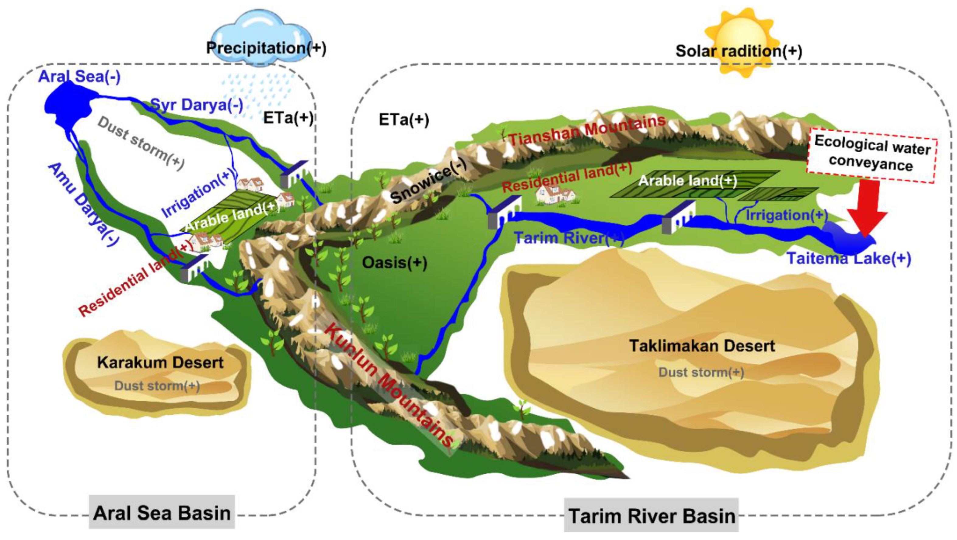
2.1. Study Area

Water resources in Central Asia are more sensitive to the impacts of climate change because the sources of water in river basins in this region are mainly snow–ice melt in mountainous areas [29]. An assessment of water resources in Central Asia by the Global International Waters Assessment Program (GIWA) concluded that 70% of development problems in Central Asia result from water deficits [42]. The Aral Sea Basin and the Tarim River Basin fall within the same latitude and represent two major river basins in Central Asia. The Amu Darya and Syr Darya Rivers are two major rivers in the Aral Sea Basin, which eventually empty into the Aral Sea terminal lake (Figure 1). The Aral Sea was the fourth largest lake globally in the 1960s, with an area of 68,478 km2 [43,44]. However, the effects of climate change and excessive exploitation and utilization of water resources by anthropogenic activities have resulted in shrinkage of the area of the Aral Sea and a sharp increase in salt content. By the end of the 20th century, the area of the Aral Sea had decreased to 25,256 km2 [29,44]. Rapid shrinkage of the Aral Sea has been widely regarded as one of the main global environmental disasters of the last century [45]. In contrast, Taitema Lake, the terminal lake originating in the Tarim River Basin, dried up completely in 1968. However, since 2000, with the orderly management of water resources in the upper reaches of the Tarim River, ecological balance in the upper reaches has been met while at the same time transporting some water downstream, allowing the ecology of the lower reaches to recover. The water area of Taitema Lake has also increased, resulting in a 3.4-fold increase in the area of low and medium vegetation cover within the lower reaches [31]. These developments indicate that anthropogenic interventions increase the uncertainty of the evolution of terminal lakes.

2.2. Data Sources

2.2.1. Meteorological and Hydrologic Data

Although regular meteorological observations in Central Asia have been conducted since the formation of the Soviet Union in the 1920s, the number of observation stations has been limited, with most concentrated in the oasis areas [25,46]. Some observation stations became inoperable after the disintegration of the former Soviet Union, resulting in periods of missing data. Therefore, this study used meteorological data from the Climatic Research Unit (CRU) dataset of the University of East Anglia, United Kingdom (https://crudata.uea.ac.uk/cru/data/hrg/ (accessed on 1 October 2021)). The CRU high-resolution lattice datasets have been widely used globally, and their accuracy and applicability in Central Asia have been verified [47,48]. The present study extracted monthly precipitation and temperature data from the CRU TS V. 4.05 dataset (University of East Anglia, Norwich, UK) covering the Tarim River Basin and the Aral Sea Basin for the period from 1990 to 2019 at a spatial resolution of 0.5°. EWC has been implemented in the Tarim River Basin since 2000. The present study obtained data for the EWC from the Tarim River Basin Administration Bureau for 2000–2019 at an annual time step.

2.2.2. Vegetation and Land Use Data

Vegetation is an important component of terrestrial surface systems [49,50]. The development of satellite remote sensing technology has made it possible to monitor large-scale dynamic changes in vegetation cover [51,52]. Satellite sensors monitoring changes in vegetation cover mainly include the Advanced Very High-Resolution Radiometer (AVHRR), Moderate Resolution Imaging Spectroradiometer (MODIS), Landsat, and SPOT [53,54]. Vegetation indices retrieved from remote sensing data include the normalized difference vegetation index (NDVI), advanced normalized vegetation index (ANVI), enhanced vegetation index (EVI), and ratio vegetation index (RVI) [55,56,57]. Among them, the NDVI algorithm is simple and has clear physical significance. Moreover, the obvious advantages of NDVI in eliminating the influence of terrain, volcanic aerosols, and other non-vegetation factors have resulted in this index becoming a standard for studying changes in vegetation cover. NDVI is a dimensionless value (−1~1). As the value tends to be closer to 1, the vegetation cover is greater in this area.
The present study used two global datasets, Global Inventory Modelling and Mapping Studies (GIMMS) 3 g NDVI and MODIS NDVI. The GIMMS3g NDVI dataset was obtained from the United States National Oceanic and Atmospheric Administration (NOAA) satellite with spatial and temporal resolutions of 0.0833° and 15 d, respectively, and a time range of 1990 to 2015. The MODIS NDVI dataset was obtained from the US National Aeronautics and Space Administration (NASA) Land Processes Distributed Active Archive Center. The MOD13A2 V6 MODIS NDVI dataset used in the present study was obtained from the MODIS sensor on the Terra satellite and has spatial and temporal resolutions of 1 km and 16 d, respectively, extending from 2016 to 2019. These datasets have been widely used to study long-term changes in the vegetation cover in many regions globally [58,59,60]. Previous studies have examined the differences between these two datasets [58,61]. The present study used the variance matching method to correct MODIS NDVI data based on GIMMS 3 g data. Finally, NDVI datasets for the Aral Sea Basin and the Tarim River Basin were obtained from 1990 to 2019.
Land use/cover data were obtained from the European Space Agency Climate Change Initiative Land Cover (ESA CCI-LC; https://www.esa-landcover-cci.org (accessed on 1 September 2021)) with a spatial resolution of 300 m and a period from 1992 to 2019. These data have been widely applied in Central Asia [14,62,63]. The present study used 1992 data as the base map, and thematic mapper (TM) images for Central Asia in 1990 were corrected based on visual interpretation. Referring to the classification results of Ma et al. [14] using this data in Central Asia, the study was divided into seven categories: arable land, grassland, forest land, desert land, water bodies, construction land, and others. The verification of land use/cover data through comparison with high-resolution Google Earth images indicated an accuracy exceeding 86%, indicating that manual interpretation of land use/cover data is applicable to Central Asia.

2.3. Methods

2.3.1. Water Area Extraction

The Google Earth Engine (GEE) platform (https://code.earthengine.google.com (accessed on 1 October 2021)) includes historical satellite imagery datasets and geospatial data exceeding 20Pb, including the Landsat dataset [64,65]. The Landsat satellites represent the longest continuous earth observation program globally and the data collected by these satellites are the most widely used form of satellite remote sensing data [66]. Therefore, the present study used Landsat series multi-spectral remote sensing satellite images on the GEE platform as the main data source. Considering the seasonal influences of lakes in the arid region and the effect of more clouds in winter on remote sensing image quality, the months of remote sensing images used in this study are mainly focused on July. Finally, images from the GEE platform were screened to eliminate images with over 20% cloud cover. The GEE platform and normalized difference water index (NDWI) [67] were applied to extract the range of area of the Aral Sea and Taitema Lake.

2.3.2. Actual Evapotranspiration

The present study used the Advection–Aridity (AA) Model based on the complementary correlation theory [68] (Equation (1)) to calculate the actual evapotranspiration (ETa) in Central Asia (Equation (2)). In this model, the Penman formula (Equation (3)) was used to calculate the potential evapotranspiration [69], and the Priestley–Taylor formula (Equation (4)) was used to calculate the evapotranspiration in a humid environment [70]. The main equations are as follows:
E T a = 2 E T w E T p
E T a = ( 2 α 1 ) Δ Δ + γ ( R n G ) Δ Δ + γ E a
E T p = Δ ( R n G ) Δ + γ + Δ E a Δ + γ
E T w = α Δ ( R n G ) Δ + γ
In Equations (1)–(4), ∆ is the slope of the temperature-saturated vapor pressure curve (KPa/°C), γ is the wet and dry surface constant (KPa/°C), Rn is the net surface radiation, defined as the difference between the net short-wave radiation and the net long-wave radiation (mm/day), and G is the soil heat flux (mm/day). The soil heat flux is negligible in comparison with the net radiation, particularly under sparse surface vegetation. Under a calculation timestep of less than 10 d, G usually approximates 0 [71]. Ea represents the drying force (mm/day). The definitions of the relevant variables in the formula are given by Allen et al. [72]. α represents the Priestley–Taylor empirical coefficient. According to Ma et al. [73] and Su et al. [74], the AA model was used for parameter calibration in the northern sand region of China and the Tarim Basin in Central Asia.

2.3.3. Trend Analysis

The unitary regression trend method can be used to analyze the trend in the variation of a single pixel and to quantify the spatial characteristics of the dynamic changes of all grids over a given period [14]. The present study used this method to evaluate the trend in the spatial variation of environmental variables in the Aral Sea Basin and the Tarim River Basin.
θ s l o p e = n × i = 1 n ( i × P i ) i = 1 n i i = 1 n P i n × i = 1 n i 2 ( i = 1 n P i ) 2
In Equation (5), θslope is the trend slope, n is the time scale, i represents a certain time node, and Pi represents the environment variable in year i. θslope > 0, θslope < 0, and θslope = 0 indicate an increase, decrease, and no change in the environmental variables during this period.

3. Results

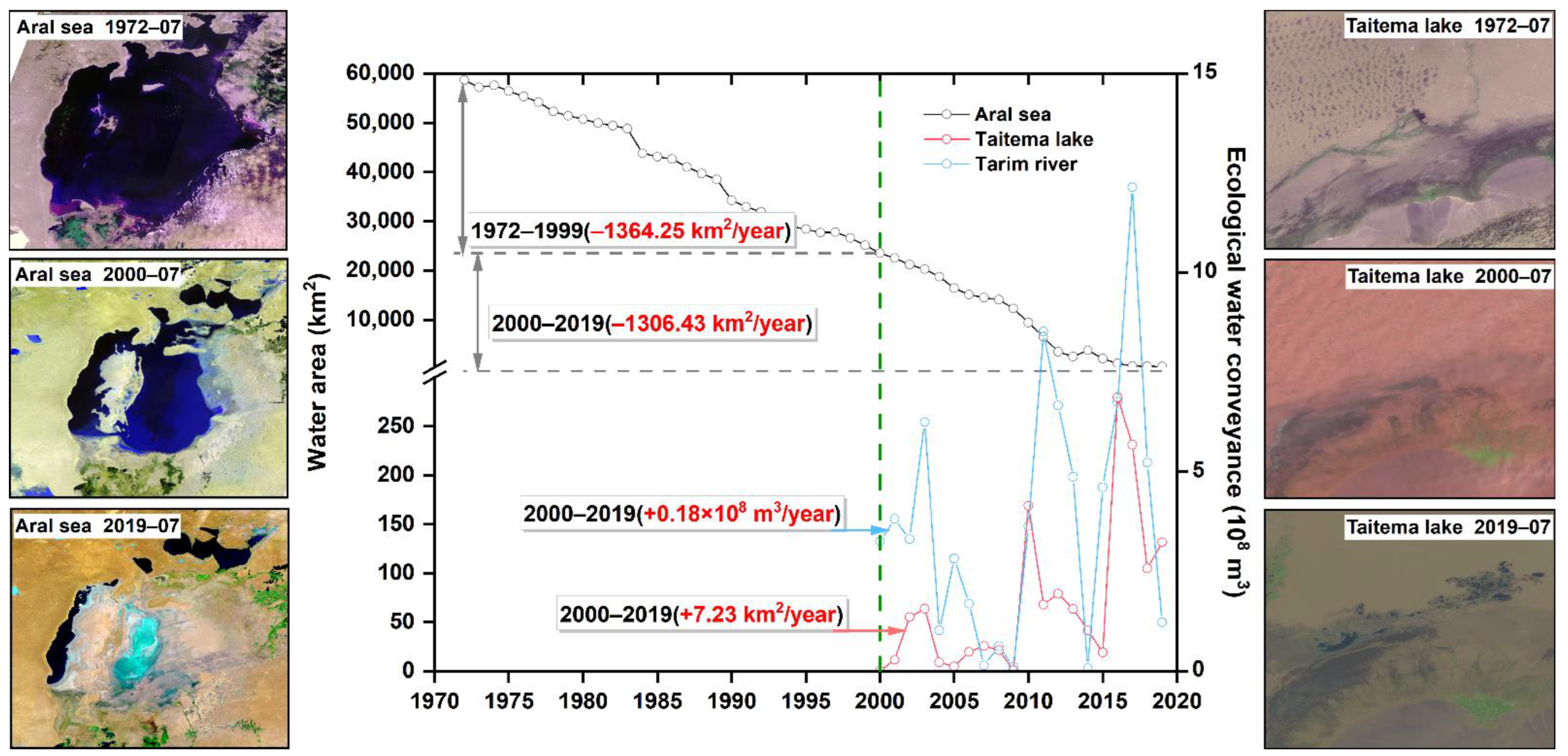
3.1. Spatiotemporal Variation in Water Resources

Figure 2 shows the changes in the water area and EWC of the Aral Sea and Taitema Lake before and after EWC (1972–2019). The results show that there was a linearly decreasing trend in the water area of the Aral Sea before EWC (1972–1999; −1364.25 km2/year). The rate of decrease slowed after 2000 (−1306.43 km2/year). Overall, the area of the Aral Sea has decreased by 98.21% over the last 48 years. Currently, submerged parts of the Aral Sea are concentrated in the north, whereas the southern part is dominated by dry riverbeds. Taitema Lake was completely dry before EWC. Since the implementation of EWC in 2000, the annual water delivery to the Tarim River will be 0.18 × 10⁸ m3/year by 2019. Consequently, the area of Taitema Lake has increased by 7.23 km2/year, mainly in the north.

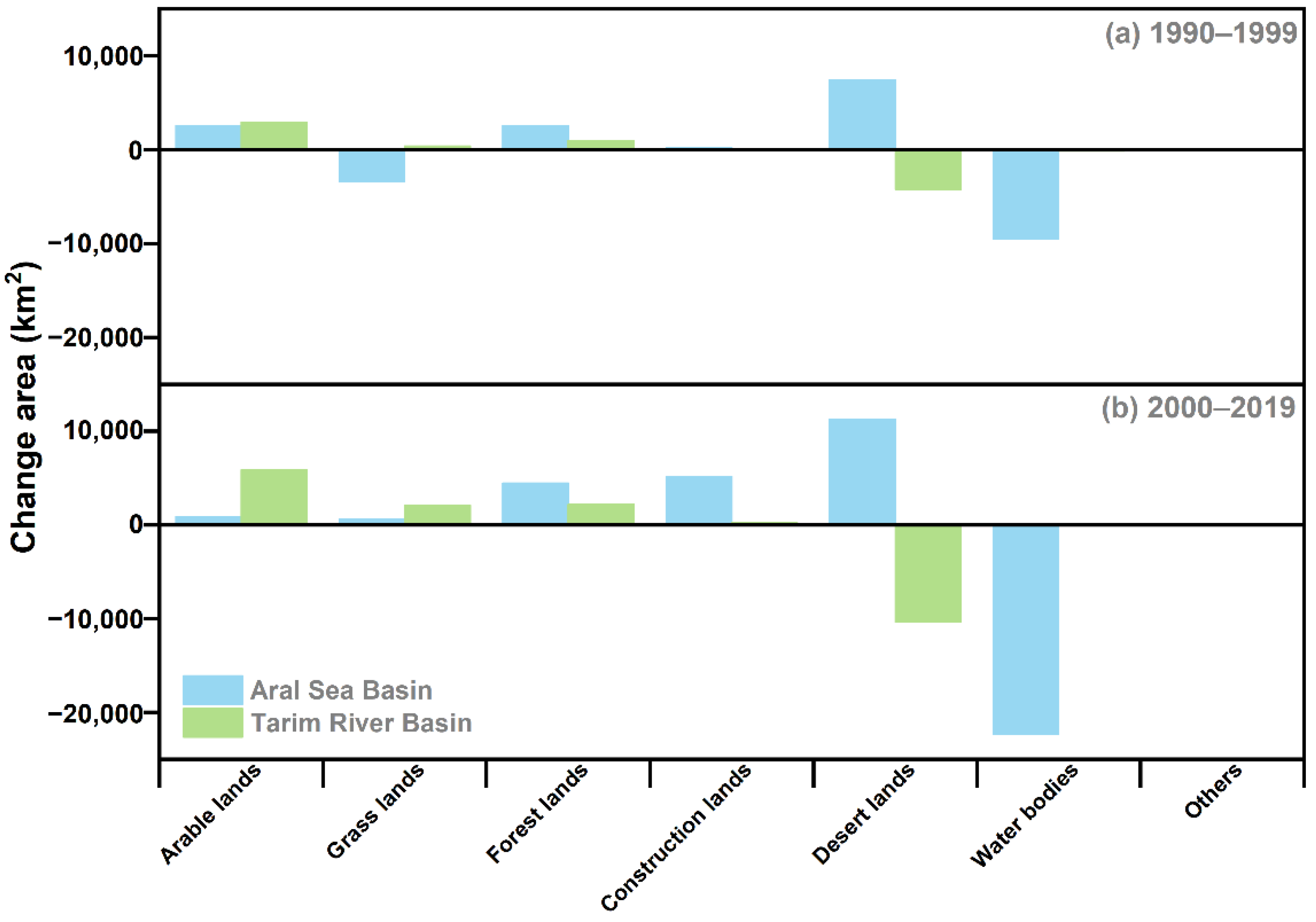
3.2. Land Use Change

Land use in the Aral Sea Basin and the Tarim River Basin changed significantly before and after EWC (1990–2019) (Figure 3 and Figure 4). Prior to EWC (1990–1999), changes in land use in the Aral Sea Basin included increases in desert land and arable land of 7455 km2 and 2594 km2, respectively, whereas there were decreases in the areas of water bodies and grassland of 9484 km2 and 3351 km2, respectively. After EWC (2000–2019), there were significant increases in the desert land and construction land of 11,277 km2 and 5115 km2, respectively, whereas there was a decrease in the area of water bodies by 22,311 km2. The increase in land for construction has mainly been influenced by urbanization. The population of the Aral Sea Basin increased by almost 35 million in 2019 compared to 1990 [75]. In contrast, changes in land use in the Tarim River Basin before EWC (1990–1999) were mainly manifested as a decrease in the area of desert land of 4221 km2 and an increase in the area of arable land of 2939 km2. After EWC (2000–2019), desert land further decreased by 10,390 km2, whereas arable land and grassland increased by 5822 km2 and 2070 km2, respectively.

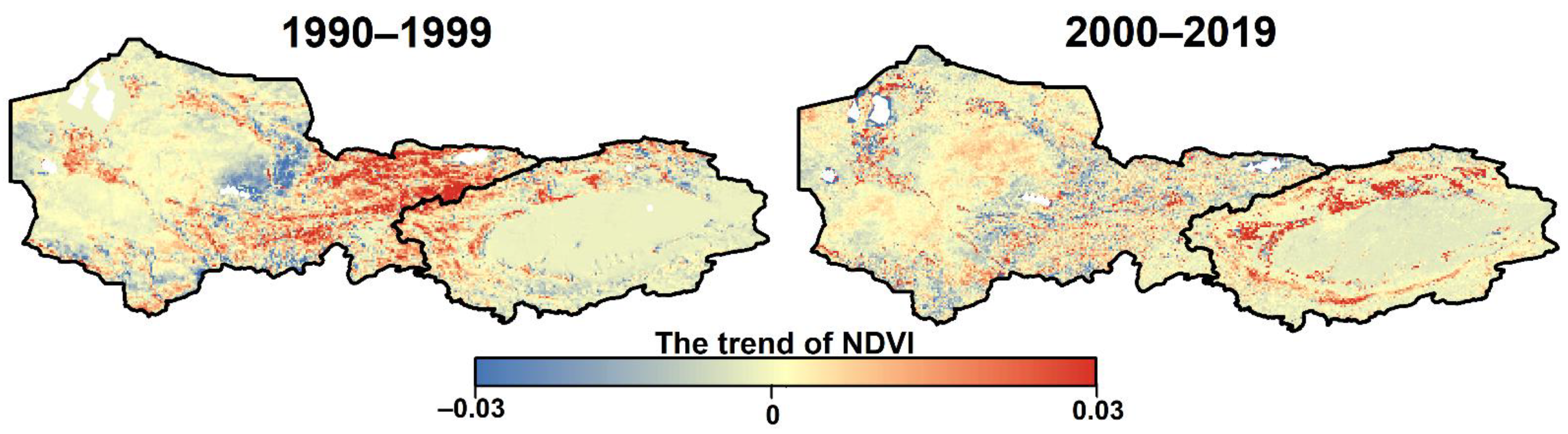
3.3. Variations in Vegetation

The NDVIs of the Aral Sea Basin and the Tarim River Basin after EWC were significantly different from those before EWC (1990–2019; Figure 5). The area showing an increase in NDVI in the Aral Sea Basin before the EWC (1990–1999) accounted for 63.1% of the entire basin, with increases mainly distributed in the upper reaches of the Amu Darya and the Syr Darya Rivers. There was a downward trend in the overall NDVI of the Aral Sea Basin after EWC (2000–2019), with areas showing a decrease in the NDVI, accounting for 51.8% of the entire basin and mainly concentrated in the upper reaches of the Amu Darya and Syr Darya Rivers.
Although there were increases in the NDVI in the Tarim River Basin before and after EWC (1990–2019), a more significant increase occurred after EWC (2000–2019). The areas showing an increase in the NDVI accounted for 72.1% of the entire basin and were mainly distributed in the oasis regions (Table 1).

3.4. Variations in ETa

The analysis of the ETa of the Aral Sea Basin and the Tarim River Basin (Figure S1; Table 2) shows an increasing trend in the Aral Sea Basin before (1990–1999) and after (2000–2019) EWC, evident in 99.54% and 100% of the basin, respectively. Prior to EWC (1990–1999), regions in the Tarim River Basin showing an increasing trend in the ETa accounted for 94.6% of the Tarim River Basin, whereas regions showing a decreasing trend were mainly distributed in the center of the Taklimakan desert. After EWC (2000–2019), the ETa increased in 98.9% of the Tarim River Basin. The ETa of the two basins shows a decreasing spatial pattern from east to west.

4. Discussion

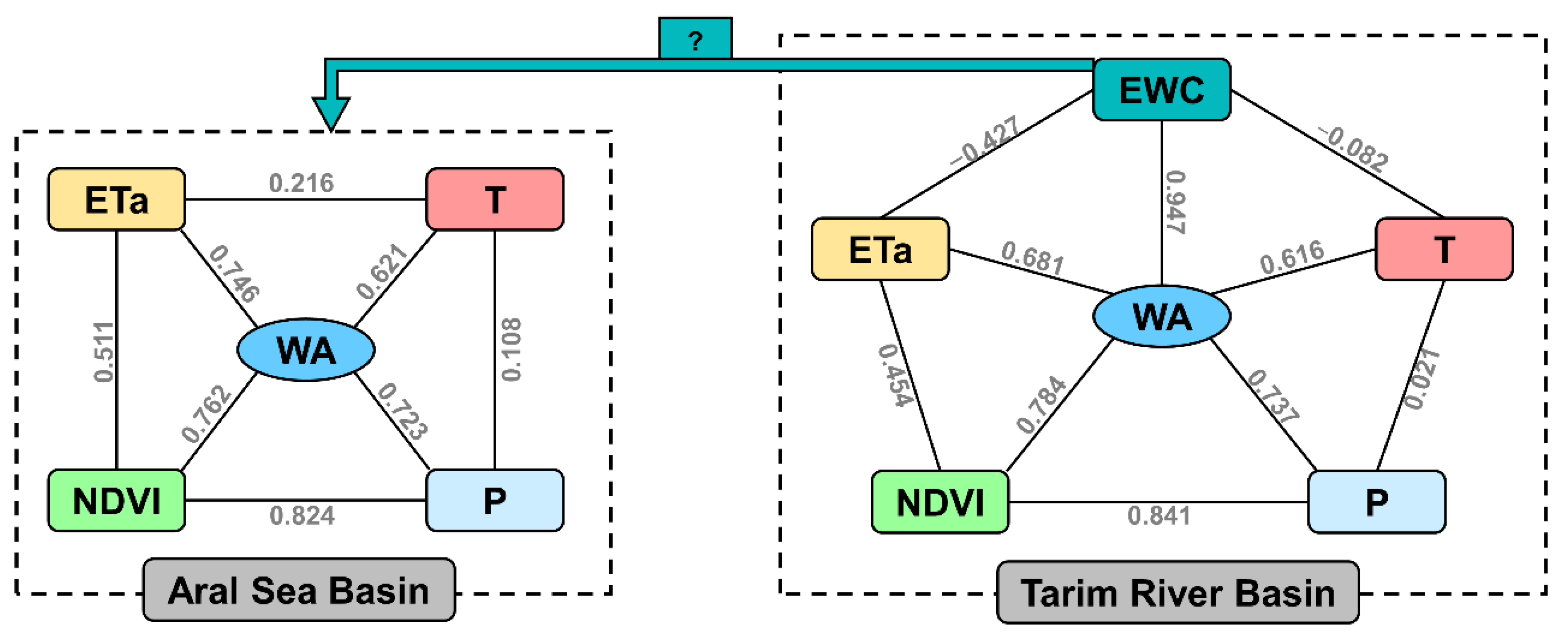
4.1. Key Factors Affecting Changes in Water Resources

The impacts of global warming have resulted in significant increases in the temperatures of the Tarim River Basin and the Aral Sea Basin in Central Asia [25,26,76,77]. A study by Chen et al. [78] determined that the warming of this region has exceeded the average of the Northern Hemisphere by a factor of two over the past century. Climate change affects regional water resources, and the water resources in the Aral Sea Basin and the Tarim River Basin are more sensitive to climate change since they are mainly supplied by snow–ice melt of headwater mountain areas [28,30,79]. An analysis of the changes in the temperature and precipitation in the Aral Sea Basin and the Tarim River Basin before and after EWC (Figure S2) shows that although there were increases in the temperature and precipitation after EWC, the range of warming in the Tarim River Basin significantly exceeded that in the Aral Sea Basin. This phenomenon can possibly be attributed to the EWC in the Tarim River Basin, changes in the regional microclimate, and an increase in the inland water vapor cycle.
Many factors regulate changes in the water resources of a basin. A study of the changes in the water resources of the Ebinur Lake Basin by Wang et al. [80] showed that an increase in the regional precipitation was the main driver of the increase in water area over the last decade. A study of the changes in water resources in many lakes on the Qinghai–Tibet Plateau by Zhang et al. [81] showed multiple sources of water supply, including precipitation, snow and glacier melting, and permafrost degradation, drove the increase in lake water resources on the Qinghai–Tibet Plateau. The present study found that the NDVI and ETa were the main factors affecting changes in the water area in the Aral Sea Basin, whereas that in the Tarim River Basin was EWC (Figure 6). EWC not only increased the NDVI in the Tarim River Basin but also led to an increase in biomass, such as the NPP, in the basin. Chen et al. [82] found that EWC increased the NPP by 7.6 g C m−2 in the Tarim River Basin. The increases in the NDVI and ETa in the Tarim River Basin are, on the one hand, due to the recovery of vegetation after EWC, and on the other hand, due to the rational and optimal allocation of agricultural water in the region and the reduction of unreasonable upstream irrigation diversions [83].

4.2. Trade-Off and Synergy Relationships of the Riparian Ecosystem in Arid Regions under Climate Change

An assessment of water resources in Central Asia by the GIWA Program concluded that 70% of the development problems in the region are initiated due to water deficits, and mainly changes in river runoff [42,85]. Although there are increasing trends in the temperature and precipitation in Central Asia [86,87], there are corresponding increasing and decreasing trends in the ETa [88,89] and soil water content [90,91], respectively. Consequently, there has been no change in the degree of drought in Central Asia [92,93]. Most of the rivers in Central Asia originate in the Tianshan Mountains, among which the Syr Darya, Amu Darya, and Tarim Rivers are the most typical (Figure 7).
The source of water resources of the Aral Sea Basin and the Tarim River Basin is mainly snow–ice melt in the headwater mountain areas. These water resources are consumed in the lower reaches through agricultural irrigation and evaporation [79,94]. Water shows an uneven spatial distribution in Central Asia, with the number of surface water resources in Kyrgyzstan and Tajikistan comprising over 70% of total water in Central Asia, whereas the consumption of these regions accounts for less than 10% of the total consumption [29,95,96]. In contrast, although the surface water resources of Kazakhstan, Uzbekistan, and Turkmenistan account for ~30% of the total water resources of Central Asia, the water consumption of these regions accounts for over 85% of the total consumption. Chen et al. [97] concluded that “The water crisis in Central Asia is not a quantitative crisis, but a distribution crisis; the problem is not water shortage, but water management”. Although water in Central Asia is plentiful, it remains poorly managed. While relevant countries and international organizations have made considerable efforts to coordinate the management of the Aral Sea Basin, problems and inter-country conflicts persist. The Tarim River Basin and the Aral Sea Basin are both important components of the arid area of Central Asia and have similar water cycles, hydrologic environments, and water resource utilization. After nearly 20 years of development, China has accumulated rich experience in the development, utilization, and management of water resources in arid areas, of which EWC is the most typical example [12,98].
China originally implemented EWC to improve the ecological environment of the terminal lakes in arid areas, which have experienced deterioration due to climate change and anthropogenic activities [31,99,100]. Long-term shrinkage in the areas of terminal lakes can be attributed to climate change [101,102]. Therefore, restoring the area of Lop Nur and other lakes to historical levels is neither practical nor economical, and the levels of these lakes can only be restored to levels of the modern area [103,104]. Schemes for the delivery of water to terminal lakes have become increasingly common and feature prominently in the life cycle of a terminal lake [37]. Therefore, the restoration of terminal lakes through EWC is a new stage of artificial intervention and reconstruction, which needs to be understood from the perspective of historical evolution.
The environmental challenge of lake restoration and reconstruction in global arid areas is particularly prominent in the Aral Sea Basin in Central Asia and fairly typical of other vast lakes in arid areas of China. The restoration of the Aral Sea involves several countries and mainly involves cross-border cooperation in water management and some engineering measures [105]. For example, as a water conservation measure, Kazakhstan constructed dams between the Large and Small Aral Seas [30] to prevent the flow of water from the Small Aral Sea to the Large Aral Sea [106]. Relevant strategies and technologies for EWC in the Tarim River can be used as a reference for the sustainable development of water in the Aral Sea Basin.

5. Conclusions

The present study adopted the Taitema Lake Basin and the Aral Sea Basin as representative of terminal lake basins in Central Asia with and without EWC, respectively. The EWC implemented in the Taitema Lake Basin was proportional to the water area of Taitema Lake. The area of Taitema Lake increased by 7.23 km2/year due to EWC (2000–2019), whereas the area of the Aral Sea Basin decreased by 98.21% throughout the natural evolution process (1972–2019). The decrease in the area of the Aral Sea was mainly due to the expansion of farming and land desertification. Although EWC significantly increased the NDVI and ETa in the Aral Sea Basin and the Taitema Lake Basin, they were the main factors affecting changes in the area of the Aral Sea, whereas EWC was the main factor affecting the change in the water area of Taitema Lake.
Ecological restoration of the Aral Sea involves the cooperation of several countries for water resource management. However, the strategies and technologies utilized for EWC in the Tarim River can be used for the sustainable development of the Aral Sea Basin. Arid zone lakes are currently facing a number of environmental problems as a result of global warming, most notably in the Aral Sea Basin. However, the EWC is expected to become a spark initiative for the sustainable development in inland lake basins.

Supplementary Materials

The following supporting information can be downloaded at: https://www.mdpi.com/article/10.3390/rs14194842/s1, Figure S1: Spatial variation in actual evaporation (ETa) in the Aral Sea Basin and the Tarim River Basin, Central Asia, before and after ecological water conveyance; Figure S2: Spatial variation in precipitation and temperature in the Aral Sea Basin and the Tarim River Basin, Central Asia, before and after ecological water conveyance.

Author Contributions

Conceptualization, W.Y. and X.M.; methodology, W.Y., Y.L. and X.M.; software, K.Q.; validation, Y.L. and X.Y.; formal analysis, J.L.; data curation, Y.W.; writing—original draft preparation, W.Y. and X.M.; writing—review and editing, W.Y.; supervision, X.M. All authors have read and agreed to the published version of the manuscript.

Funding

This research was funded by the National Natural Science Foundation of China (42101302), the China Postdoctoral Science Foundation (2021M703470), the Key Scientific Research Project in Colleges and Universities of Henan Province (22A170019), the Strategic Priority Research Program of the Chinese Academy of Sciences (XDA2006030201), and the Nanhu Scholars Program for Young Scholars of XYNU.

Data Availability Statement

Not applicable.

Acknowledgments

We would like to express our sincere thanks to the anonymous reviewers.

Conflicts of Interest

The authors declare no conflict of interest.

References

  1. Cosgrove, W.J.; Loucks, D.P. Water management: Current and future challenges and research directions. Water Resour. Res. 2015, 51, 4823–4839. [Google Scholar] [CrossRef]
  2. Fu, B.; Wang, S.; Zhang, J.; Hou, Z.; Li, J. Unravelling the complexity in achieving the 17 sustainable-development goals. Natl. Sci. Rev. 2019, 6, 386–388. [Google Scholar] [CrossRef] [PubMed]
  3. Michael, H.A.; Post, V.E.A.; Wilson, A.M.; Werner, A.D. Science, society, and the coastal groundwater squeeze. Water Resour. Res. 2017, 53, 2610–2617. [Google Scholar] [CrossRef]
  4. Ma, H.; Zhu, G.; Zhang, Y.; Pan, H.; Guo, H.; Jia, W.; Zhou, J.; Yong, L.; Wan, Q. The effects of runoff on Hydrochemistry in the Qilian Mountains: A case study of Xiying River Basin. Environ. Earth Sci. 2019, 78, 385. [Google Scholar] [CrossRef]
  5. Yao, Y.; Zheng, C.; Liu, J.; Cao, G.; Xiao, H.; Li, H.; Li, W. Conceptual and numerical models for groundwater flow in an arid inland river basin. Hydrol. Process. 2015, 29, 1480–1492. [Google Scholar] [CrossRef]
  6. Messager, M.L.; Lehner, B.; Grill, G.; Nedeva, I.; Schmitt, O. Estimating the volume and age of water stored in global lakes using a geo-statistical approach. Nat. Commun. 2016, 7, 13603. [Google Scholar] [CrossRef]
  7. Verpoorter, C.; Kutser, T.; Seekell, D.A.; Tranvik, L.J. A global inventory of lakes based on high-resolution satellite imagery. Geophys. Res. Lett. 2014, 41, 6396–6402. [Google Scholar] [CrossRef]
  8. Ma, R.; Duan, H.; Hu, C.; Feng, X.; Li, A.; Ju, W.; Jiang, J.; Yang, G. A half-century of changes in China’s lakes: Global warming or human influence? Geophys. Res. Lett. 2010, 37, L24106. [Google Scholar] [CrossRef]
  9. Tao, S.; Fang, J.; Ma, S.; Cai, Q.; Xiong, X.; Tian, D.; Zhao, X.; Fang, L.; Zhang, H.; Zhu, J.; et al. Changes in China’s lakes: Climate and human impacts. Natl. Sci. Rev. 2020, 7, 132–140. [Google Scholar] [CrossRef]
  10. Huang, F.; Chunyu, X.; Zhang, D.; Chen, X.; Ochoa, C.G. A framework to assess the impact of ecological water conveyance on groundwater-dependent terrestrial ecosystems in arid inland river basins. Sci. Total Environ. 2020, 709, 136155. [Google Scholar] [CrossRef]
  11. Si, J.; Feng, Q.; Yu, T.; Zhao, C. Inland river terminal lake preservation: Determining basin scale and the ecological water requirement. Environ. Earth Sci. 2015, 73, 3327–3334. [Google Scholar] [CrossRef]
  12. Zhu, Y.; Chen, Y.; Ren, L.; Lü, H.; Zhao, W.; Yuan, F.; Xu, M. Ecosystem restoration and conservation in the arid inland river basins of Northwest China: Problems and strategies. Ecol. Eng. 2016, 94, 629–637. [Google Scholar] [CrossRef]
  13. Ling, H.; Yan, J.; Guo, B.; Xu, H.; Li, X.; Deng, X. Evaluation of water and land exploitation based on the ecosystem service value in a hyper-arid region with intensifying basin management. Land Degrad. Dev. 2019, 30, 2165–2176. [Google Scholar] [CrossRef]
  14. Ma, X.; Zhu, J.; Yan, W.; Zhao, C. Projections of desertification trends in Central Asia under global warming scenarios. Sci. Total Environ. 2021, 781, 146777. [Google Scholar] [CrossRef] [PubMed]
  15. Legesse, D.; Vallet-Coulomb, C.; Gasse, F. Analysis of the hydrological response of a tropical terminal lake, Lake Abiyata (Main Ethiopian Rift Valley) to changes in climate and human activities. Hydrol. Process. 2004, 18, 487–504. [Google Scholar] [CrossRef]
  16. Seitz, C.; Vélez, M.I.; Perillo, G.M.E. Response of shallow lakes in the arid-semiarid Pampas of Argentina to Late Holocene hydroclimatic change. Quat. Int. 2022, 607, 35–47. [Google Scholar] [CrossRef]
  17. Abuduwaili, J.; Liu, D.; Wu, G. Saline dust storms and their ecological impacts in arid regions. J. Arid Land 2010, 2, 144–150. [Google Scholar] [CrossRef]
  18. Ge, Y.; Abuduwaili, J.; Ma, L.; Liu, D. Temporal Variability and Potential Diffusion Characteristics of Dust Aerosol Originating from the Aral Sea Basin, Central Asia. Water Air Soil Pollut. 2016, 227, 63. [Google Scholar] [CrossRef]
  19. Zhang, M.; Wang, S.; Fu, B.; Gao, G.; Shen, Q. Ecological effects and potential risks of the water diversion project in the Heihe River Basin. Sci. Total Environ. 2018, 619–620, 794–803. [Google Scholar] [CrossRef]
  20. Chen, Y.; Li, W.; Xu, C.; Ye, Z.; Chen, Y. Desert riparian vegetation and groundwater in the lower reaches of the Tarim River basin. Environ. Earth Sci. 2015, 73, 547–558. [Google Scholar] [CrossRef]
  21. Ling, H.; Guo, B.; Xu, H.; Fu, J. Configuration of water resources for a typical river basin in an arid region of China based on the ecological water requirements (EWRs) of desert riparian vegetation. Glob. Planet. Chang. 2014, 122, 292–304. [Google Scholar] [CrossRef]
  22. Ling, H.; Guo, B.; Yan, J.; Deng, X.; Xu, H.; Zhang, G. Enhancing the positive effects of ecological water conservancy engineering on desert riparian forest growth in an arid basin. Ecol. Ind. 2020, 118, 106797. [Google Scholar] [CrossRef]
  23. Huang, W.; Duan, W.; Chen, Y. Rapidly declining surface and terrestrial water resources in Central Asia driven by socio-economic and climatic changes. Sci. Total Environ. 2021, 784, 147193. [Google Scholar] [CrossRef] [PubMed]
  24. Shen, Y.-J.; Shen, Y.; Goetz, J.; Brenning, A. Spatial-temporal variation of near-surface temperature lapse rates over the Tianshan Mountains, central Asia. J. Geophys. Res. Atmos. 2016, 121, 14006–14017. [Google Scholar] [CrossRef]
  25. Hu, Z.; Zhang, C.; Hu, Q.; Tian, H. Temperature Changes in Central Asia from 1979 to 2011 Based on Multiple Datasets. J. Climate 2014, 27, 1143–1167. [Google Scholar] [CrossRef]
  26. Ma, X.; Zhu, J.; Yan, W.; Zhao, C. Assessment of soil conservation services of four river basins in Central Asia under global warming scenarios. Geoderma 2020, 375, 114533. [Google Scholar] [CrossRef]
  27. Kagalou, I.; Psilovikos, A. Assessment of the typology and the trophic status of two Mediterranean lake ecosystems in Northwestern Greece. Water Resour. 2014, 41, 335–343. [Google Scholar] [CrossRef]
  28. He, H.; Hamdi, R.; Cai, P.; Luo, G.; Ochege, F.U.; Zhang, M.; Termonia, P.; De Maeyer, P.; Li, C. Impacts of Historical Land Use/Cover Change (1980–2015) on Summer Climate in the Aral Sea Region. J. Geophys. Res. Atmos. 2021, 126, e2020JD032638. [Google Scholar] [CrossRef]
  29. Shi, H.; Luo, G.; Zheng, H.; Chen, C.; Hellwich, O.; Bai, J.; Liu, T.; Liu, S.; Xue, J.; Cai, P.; et al. A novel causal structure-based framework for comparing a basin-wide water–energy–food–ecology nexus applied to the data-limited Amu Darya and Syr Darya river basins. Hydrol. Earth Syst. Sci. 2021, 25, 901–925. [Google Scholar] [CrossRef]
  30. Micklin, P. The future Aral Sea: Hope and despair. Environ. Earth Sci. 2016, 75, 844. [Google Scholar] [CrossRef]
  31. Dou, X.; Ma, X.; Huo, T.; Zhu, J.; Zhao, C. Assessment of the environmental effects of ecological water conveyance over 31 years for a terminal lake in Central Asia. CATENA 2022, 208, 105725. [Google Scholar] [CrossRef]
  32. Liu, D.; Tian, F.; Lin, M.; Sivapalan, M. A conceptual socio-hydrological model of the co-evolution of humans and water: Case study of the Tarim River basin, western China. Hydrol. Earth Syst. Sci. 2015, 19, 1035–1054. [Google Scholar] [CrossRef]
  33. Li, F.; Huang, J.; Zeng, G.; Yuan, X.; Li, X.; Liang, J.; Wang, X.; Tang, X.; Bai, B. Spatial risk assessment and sources identification of heavy metals in surface sediments from the Dongting Lake, Middle China. J. Geochem. Explor. 2013, 132, 75–83. [Google Scholar] [CrossRef]
  34. Wang, W.; Yuan, W.; Chen, Y.; Wang, J. Microplastics in surface waters of Dongting Lake and Hong Lake, China. Sci. Total Environ. 2018, 633, 539–545. [Google Scholar] [CrossRef]
  35. Yuan, Y.; Zeng, G.; Liang, J.; Huang, L.; Hua, S.; Li, F.; Zhu, Y.; Wu, H.; Liu, J.; He, X.; et al. Variation of water level in Dongting Lake over a 50-year period: Implications for the impacts of anthropogenic and climatic factors. J. Hydrol. 2015, 525, 450–456. [Google Scholar] [CrossRef]
  36. Bai, J.; Chen, X.; Li, J.; Yang, L.; Fang, H. Changes in the area of inland lakes in arid regions of central Asia during the past 30 years. Environ. Monit. Assess. 2011, 178, 247–256. [Google Scholar] [CrossRef]
  37. Hu, S.; Ma, R.; Sun, Z.; Ge, M.; Zeng, L.; Huang, F.; Bu, J.; Wang, Z. Determination of the optimal ecological water conveyance volume for vegetation restoration in an arid inland river basin, northwestern China. Sci. Total Environ. 2021, 788, 147775. [Google Scholar] [CrossRef] [PubMed]
  38. Karamoutsou, L.; Psilovikos, A.; Spiridis, A.; Koutalou, V.; Stalnacke, P. Modifications in the Vegoritida’s Lake Catchment and Water Level during the Last Sixty Years. In Proceedings of the 2nd International Congress on Applied Ichthyology & Aquatic Environment, Messolonghi, Greece, 10–12 November 2016. [Google Scholar]
  39. Salameh, E.; Bandel, K.; Alhejoj, I.; Abdallat, G. Evolution and Termination of Lakes in Jordan and Their Relevance to Human Migration from Africa to Asia and Europe. Open J. Geol. 2018, 8, 1113–1132. [Google Scholar] [CrossRef]
  40. Chunyu, X.; Huang, F.; Xia, Z.; Zhang, D.; Chen, X.; Xie, Y. Assessing the Ecological Effects of Water Transport to a Lake in Arid Regions: A Case Study of Qingtu Lake in Shiyang River Basin, Northwest China. Int. J. Environ. Res. Public Health 2019, 16, 145. [Google Scholar] [CrossRef]
  41. Zhang, Z.; Zheng, Y.; Han, F.; Xiong, R.; Feng, L. Recovery of an endorheic lake after a decade of conservation efforts: Mediating the water conflict between agriculture and ecosystems. Agric. Water Manag. 2021, 256, 107107. [Google Scholar] [CrossRef]
  42. Severskiy, I.V. Water-related Problems of Central Asia: Some Results of the (GIWA) International Water Assessment Program. AMBIO: A J. Hum. Environ. 2004, 33, 52–62. [Google Scholar] [CrossRef]
  43. Deliry, S.I.; Avdan, Z.Y.; Do, N.T.; Avdan, U. Assessment of human-induced environmental disaster in the Aral Sea using Landsat satellite images. Environ. Earth Sci. 2020, 79, 471. [Google Scholar] [CrossRef]
  44. Yang, X.; Wang, N.; Chen, A.A.; He, J.; Hua, T.; Qie, Y. Changes in area and water volume of the Aral Sea in the arid Central Asia over the period of 1960–2018 and their causes. CATENA 2020, 191, 104566. [Google Scholar] [CrossRef]
  45. Micklin, P. The Aral Sea Disaster. Annu. Rev. Earth Planet. Sci. 2007, 35, 47–72. [Google Scholar] [CrossRef]
  46. Khromova, T.E.; Osipova, G.B.; Tsvetkov, D.G.; Dyurgerov, M.B.; Barry, R.G. Changes in glacier extent in the eastern Pamir, Central Asia, determined from historical data and ASTER imagery. Remote Sens. Environ. 2006, 102, 24–32. [Google Scholar] [CrossRef]
  47. Luo, M.; Liu, T.; Meng, F.; Duan, Y.; Bao, A.; Frankl, A.; De Maeyer, P. Spatiotemporal characteristics of future changes in precipitation and temperature in Central Asia. Int. J. Climatol. 2019, 39, 1571–1588. [Google Scholar] [CrossRef]
  48. Peng, D.; Zhou, T.; Zhang, L.; Zou, L. Detecting human influence on the temperature changes in Central Asia. Clim. Dyn. 2019, 53, 4553–4568. [Google Scholar] [CrossRef]
  49. Foley, J.A.; Prentice, I.C.; Ramankutty, N.; Levis, S.; Pollard, D.; Sitch, S.; Haxeltine, A. An integrated biosphere model of land surface processes, terrestrial carbon balance, and vegetation dynamics. Glob. Biogeochem. Cycles 1996, 10, 603–628. [Google Scholar] [CrossRef]
  50. Friend, A.D.; Lucht, W.; Rademacher, T.T.; Keribin, R.; Betts, R.; Cadule, P.; Ciais, P.; Clark, D.B.; Dankers, R.; Falloon, P.D.; et al. Carbon residence time dominates uncertainty in terrestrial vegetation responses to future climate and atmospheric CO2. Proc. Natl. Acad. Sci. USA 2014, 111, 3280–3285. [Google Scholar] [CrossRef]
  51. Fang, X.; Zhu, Q.; Ren, L.; Chen, H.; Wang, K.; Peng, C. Large-scale detection of vegetation dynamics and their potential drivers using MODIS images and BFAST: A case study in Quebec, Canada. Remote Sens. Environ. 2018, 206, 391–402. [Google Scholar] [CrossRef]
  52. Xie, Y.; Sha, Z.; Yu, M. Remote sensing imagery in vegetation mapping: A review. J. Plant Ecol. 2008, 1, 9–23. [Google Scholar] [CrossRef]
  53. Albarakat, R.; Lakshmi, V. Comparison of Normalized Difference Vegetation Index Derived from Landsat, MODIS, and AVHRR for the Mesopotamian Marshes Between 2002 and 2018. Remote Sens. 2019, 11, 1245. [Google Scholar] [CrossRef]
  54. Ke, Y.; Im, J.; Lee, J.; Gong, H.; Ryu, Y. Characteristics of Landsat 8 OLI-derived NDVI by comparison with multiple satellite sensors and in-situ observations. Remote Sens. Environ. 2015, 164, 298–313. [Google Scholar] [CrossRef]
  55. Kim, Y.; Jackson, T.; Bindlish, R.; Lee, H.; Hong, S. Radar Vegetation Index for Estimating the Vegetation Water Content of Rice and Soybean. IEEE Geosci. Remote Sens. Lett. 2012, 9, 564–568. [Google Scholar] [CrossRef]
  56. Ren, H.; Feng, G. Are soil-adjusted vegetation indices better than soil-unadjusted vegetation indices for above-ground green biomass estimation in arid and semi-arid grasslands? Grass Forage Sci. 2015, 70, 611–619. [Google Scholar] [CrossRef]
  57. Sha, Z.Y.; Bai, Y.F. Building Long-Term and Consistent Vegetation Index Based on Association Analysis between Different VI Products. Adv. Mater. Res. 2012, 518–523, 5261–5266. [Google Scholar] [CrossRef]
  58. Fensholt, R.; Proud, S.R. Evaluation of Earth Observation based global long term vegetation trends—Comparing GIMMS and MODIS global NDVI time series. Remote Sens. Environ. 2012, 119, 131–147. [Google Scholar] [CrossRef]
  59. Tian, F.; Fensholt, R.; Verbesselt, J.; Grogan, K.; Horion, S.; Wang, Y. Evaluating temporal consistency of long-term global NDVI datasets for trend analysis. Remote Sens. Environ. 2015, 163, 326–340. [Google Scholar] [CrossRef]
  60. Zhang, Y.; Song, C.; Band, L.E.; Sun, G.; Li, J. Reanalysis of global terrestrial vegetation trends from MODIS products: Browning or greening? Remote Sens. Environ. 2017, 191, 145–155. [Google Scholar] [CrossRef]
  61. Xiao, Z.; Liang, S.; Tian, X.; Jia, K.; Yao, Y.; Jiang, B. Reconstruction of Long-Term Temporally Continuous NDVI and Surface Reflectance from AVHRR Data. IEEE J. Sel. Top. Appl. Earth Obs. Rem. Sens. 2017, 10, 5551–5568. [Google Scholar] [CrossRef]
  62. Jiang, L.; Jiapaer, G.; Bao, A.; Li, Y.; Guo, H.; Zheng, G.; Chen, T.; De Maeyer, P. Assessing land degradation and quantifying its drivers in the Amudarya River delta. Ecol. Ind. 2019, 107, 105595. [Google Scholar] [CrossRef]
  63. Li, J.; Chen, X.; Kurban, A.; Van de Voorde, T.; De Maeyer, P.; Zhang, C. Identification of conservation priorities in the major basins of Central Asia: Using an integrated GIS-based ordered weighted averaging approach. J. Environ. Manag. 2021, 298, 113442. [Google Scholar] [CrossRef] [PubMed]
  64. Huang, H.; Chen, Y.; Clinton, N.; Wang, J.; Wang, X.; Liu, C.; Gong, P.; Yang, J.; Bai, Y.; Zheng, Y.; et al. Mapping major land cover dynamics in Beijing using all Landsat images in Google Earth Engine. Remote Sens. Environ. 2017, 202, 166–176. [Google Scholar] [CrossRef]
  65. Phalke, A.R.; Özdoğan, M.; Thenkabail, P.S.; Erickson, T.; Gorelick, N.; Yadav, K.; Congalton, R.G. Mapping croplands of Europe, Middle East, Russia, and Central Asia using Landsat, Random Forest, and Google Earth Engine. ISPRS J. Photogramm. Remote Sens. 2020, 167, 104–122. [Google Scholar] [CrossRef]
  66. Wulder, M.A.; White, J.C.; Loveland, T.R.; Woodcock, C.E.; Belward, A.S.; Cohen, W.B.; Fosnight, E.A.; Shaw, J.; Masek, J.G.; Roy, D.P. The global Landsat archive: Status, consolidation, and direction. Remote Sens. Environ. 2016, 185, 271–283. [Google Scholar] [CrossRef]
  67. McFeeters, S.K. The use of the Normalized Difference Water Index (NDWI) in the delineation of open water features. Int. J. Remote Sens. 1996, 17, 1425–1432. [Google Scholar] [CrossRef]
  68. Brutsaert, W.; Stricker, H. An advection-aridity approach to estimate actual regional evapotranspiration. Water Resour. Res. 1979, 15, 443–450. [Google Scholar] [CrossRef]
  69. Penman, H.L. Natural evaporation from open water, bare soil and grass. Proc. R. Soc. Lond. A. Math. Phys. Sci. 1948, 193, 120–145. [Google Scholar] [CrossRef]
  70. Priestley, C.H.B.; Taylor, R.J. On the Assessment of Surface Heat Flux and Evaporation Using Large-Scale Parameters. Mon. Weather. Rev. 1972, 100, 81–92. [Google Scholar] [CrossRef]
  71. Jian, D.; Li, X.; Sun, H.; Tao, H.; Jiang, T.; Su, B.; Hartmann, H. Estimation of Actual Evapotranspiration by the Complementary Theory-Based Advection–Aridity Model in the Tarim River Basin, China. J. Hydrometeor. 2018, 19, 289–303. [Google Scholar] [CrossRef]
  72. Allen, R.G.; Pereira, L.S.; Raes, D.; Smith, M. FAO Irrigation and Drainage Paper No. 56 Crop Evapotranspiration; FAO: Rome, Italy, 1998; p. 156. [Google Scholar]
  73. Ma, X.; Zhao, C.; Tao, H.; Zhu, J.; Kundzewicz, Z.W. Projections of actual evapotranspiration under the 1.5 °C and 2.0 °C global warming scenarios in sandy areas in northern China. Sci. Total Environ. 2018, 645, 1496–1508. [Google Scholar] [CrossRef]
  74. Su, B.; Jian, D.; Li, X.; Wang, Y.; Wang, A.; Wen, S.; Tao, H.; Hartmann, H. Projection of actual evapotranspiration using the COSMO-CLM regional climate model under global warming scenarios of 1.5 °C and 2.0 °C in the Tarim River basin, China. Atmos. Res. 2017, 196, 119–128. [Google Scholar] [CrossRef]
  75. Berdimbetov, T.; Ilyas, S.; Ma, Z.; Bilal, M.; Nietullaeva, S. Climatic Change and Human Activities Link to Vegetation Dynamics in the Aral Sea Basin Using NDVI. Earth. Syst. Environ. 2021, 5, 303–318. [Google Scholar] [CrossRef]
  76. Chen, F.; Huang, W.; Jin, L.; Chen, J.; Wang, J. Spatiotemporal precipitation variations in the arid Central Asia in the context of global warming. Sci. China Earth Sci. 2011, 54, 1812–1821. [Google Scholar] [CrossRef]
  77. Zhang, M.; Luo, G.; De Maeyer, P.; Cai, P.; Kurban, A. Improved Atmospheric Modelling of the Oasis-Desert System in Central Asia Using WRF with Actual Satellite Products. Remote Sens. 2017, 9, 1273. [Google Scholar] [CrossRef]
  78. Chen, F.; Wang, J.; Jin, L.; Zhang, Q.; Li, J.; Chen, J. Rapid warming in mid-latitude central Asia for the past 100 years. Front. Earth Sci. China 2009, 3, 42. [Google Scholar] [CrossRef]
  79. Lobanova, A.; Didovets, I.; Menz, C.; Umirbekov, A.; Babagalieva, Z.; Hattermann, F.; Krysanova, V. Rapid assessment of climate risks for irrigated agriculture in two river basins in the Aral Sea Basin. Agric. Water Manag. 2021, 243, 106381. [Google Scholar] [CrossRef]
  80. Wang, J.; Ding, J.; Li, G.; Liang, J.; Yu, D.; Aishan, T.; Zhang, F.; Yang, J.; Abulimiti, A.; Liu, J. Dynamic detection of water surface area of Ebinur Lake using multi-source satellite data (Landsat and Sentinel-1A) and its responses to changing environment. CATENA 2019, 177, 189–201. [Google Scholar] [CrossRef]
  81. Zhang, G.; Yao, T.; Chen, W.; Zheng, G.; Shum, C.K.; Yang, K.; Piao, S.; Sheng, Y.; Yi, S.; Li, J.; et al. Regional differences of lake evolution across China during 1960s–2015 and its natural and anthropogenic causes. Remote Sens. Environ. 2019, 221, 386–404. [Google Scholar] [CrossRef]
  82. Chen, Y.; Chen, Y.; Zhu, C.; Wang, Y.; Hao, X. Ecohydrological effects of water conveyance in a disconnected river in an arid inland river basin. Sci. Rep. 2022, 12, 9982. [Google Scholar] [CrossRef] [PubMed]
  83. Huang, Y.; Li, Y.P.; Chen, X.; Ma, Y.G. Optimization of the irrigation water resources for agricultural sustainability in Tarim River Basin, China. Agric. Water Manag. 2012, 107, 74–85. [Google Scholar] [CrossRef]
  84. Benesty, J.; Chen, J.; Huang, Y.; Cohen, I. Pearson correlation coefficient. In Noise Reduction in Speech Processing; Springer: Berlin/Heidelberg, Germay, 2009. [Google Scholar]
  85. Bekturganov, Z.; Tussupova, K.; Berndtsson, R.; Sharapatova, N.; Aryngazin, K.; Zhanasova, M. Water Related Health Problems in Central Asia—A Review. Water 2016, 8, 219. [Google Scholar] [CrossRef]
  86. Xu, M.; Kang, S.; Wu, H.; Yuan, X. Detection of spatio-temporal variability of air temperature and precipitation based on long-term meteorological station observations over Tianshan Mountains, Central Asia. Atmos. Res. 2018, 203, 141–163. [Google Scholar] [CrossRef]
  87. Yao, J.; Chen, Y. Trend analysis of temperature and precipitation in the Syr Darya Basin in Central Asia. Theor. Appl. Climatol. 2015, 120, 521–531. [Google Scholar] [CrossRef]
  88. Chen, H.; Liu, H.; Chen, X.; Qiao, Y. Analysis on impacts of hydro-climatic changes and human activities on available water changes in Central Asia. Sci. Total Environ. 2020, 737, 139779. [Google Scholar] [CrossRef]
  89. Zhang, Q.; Yang, Z.; Hao, X.; Yue, P. Conversion features of evapotranspiration responding to climate warming in transitional climate regions in northern China. Clim. Dyn. 2019, 52, 3891–3903. [Google Scholar] [CrossRef]
  90. Li, Z.; Chen, Y.; Fang, G.; Li, Y. Multivariate assessment and attribution of droughts in Central Asia. Sci. Rep. 2017, 7, 1316. [Google Scholar] [CrossRef]
  91. Liu, D.; Wang, G.; Mei, R.; Yu, Z.; Yu, M. Impact of initial soil moisture anomalies on climate mean and extremes over Asia. J. Geophys. Res. Atmos. 2014, 119, 529–545. [Google Scholar] [CrossRef]
  92. Guo, H.; Bao, A.; Ndayisaba, F.; Liu, T.; Jiapaer, G.; El-Tantawi, A.M.; De Maeyer, P. Space-time characterization of drought events and their impacts on vegetation in Central Asia. J. Hydrol. 2018, 564, 1165–1178. [Google Scholar] [CrossRef]
  93. Zhang, X.; He, M.; Bai, M.; Ge, Q. Meteorological drought and its large-scale climate patterns in each season in Central Asia from 1901 to 2015. Clim. Chang. 2021, 166, 41. [Google Scholar] [CrossRef]
  94. Horst, M.G.; Shamutalov, S.S.; Pereira, L.S.; Gonçalves, J.M. Field assessment of the water saving potential with furrow irrigation in Fergana, Aral Sea basin. Agric. Water Manag. 2005, 77, 210–231. [Google Scholar] [CrossRef]
  95. Shi, H.; Luo, G.; Zheng, H.; Chen, C.; Bai, J.; Liu, T.; Ochege, F.U.; De Maeyer, P. Coupling the water-energy-food-ecology nexus into a Bayesian network for water resources analysis and management in the Syr Darya River basin. J. Hydrol. 2020, 581, 124387. [Google Scholar] [CrossRef]
  96. Wu, T.; Sang, S.; Wang, S.; Yang, Y.; Li, M. Remote sensing assessment and spatiotemporal variations analysis of ecological carrying capacity in the Aral Sea Basin. Sci. Total Environ. 2020, 735, 139562. [Google Scholar] [CrossRef]
  97. Chen, Y.; Li, Z.; Fang, G.; Li, W. Large Hydrological Processes Changes in the Transboundary Rivers of Central Asia. J. Geophys. Res. Atmos. 2018, 123, 5059–5069. [Google Scholar] [CrossRef]
  98. Zeng, Y.; Xie, Z.; Yu, Y.; Liu, S.; Wang, L.; Jia, B.; Qin, P.; Chen, Y. Ecohydrological effects of stream–aquifer water interaction: A case study of the Heihe River basin, northwestern China. Hydrol. Earth Syst. Sci. 2016, 20, 2333–2352. [Google Scholar] [CrossRef]
  99. Karthe, D. Environmental Changes in Central and East Asian Drylands and their Effects on Major River-Lake Systems. Quat. Int. 2018, 475, 91–100. [Google Scholar] [CrossRef]
  100. Niswonger, R.G.; Allander, K.K.; Jeton, A.E. Collaborative modelling and integrated decision support system analysis of a developed terminal lake basin. J. Hydrol. 2014, 517, 521–537. [Google Scholar] [CrossRef]
  101. Ke, L.; Song, C.; Wang, J.; Sheng, Y.; Ding, X.; Yong, B.; Ma, R.; Liu, K.; Zhan, P.; Luo, S. Constraining the contribution of glacier mass balance to the Tibetan lake growth in the early 21st century. Remote Sens. Environ. 2022, 268, 112779. [Google Scholar] [CrossRef]
  102. Zheng, L.; Xia, Z.; Xu, J.; Chen, Y.; Yang, H.; Li, D. Exploring annual lake dynamics in Xinjiang (China): Spatiotemporal features and driving climate factors from 2000 to 2019. Clim. Chang. 2021, 166, 36. [Google Scholar] [CrossRef]
  103. An, L.; Wang, J.; Huang, J.; Pokhrel, Y.; Hugonnet, R.; Wada, Y.; Cáceres, D.; Müller Schmied, H.; Song, C.; Berthier, E.; et al. Divergent Causes of Terrestrial Water Storage Decline Between Drylands and Humid Regions Globally. Geophys. Res. Lett. 2021, 48, e2021GL095035. [Google Scholar] [CrossRef]
  104. Bennion, H.; Battarbee, R.W.; Sayer, C.D.; Simpson, G.L.; Davidson, T.A. Defining reference conditions and restoration targets for lake ecosystems using palaeolimnology: A synthesis. J. Paleolimnol. 2011, 45, 533–544. [Google Scholar] [CrossRef]
  105. Lee, S.O.; Jung, Y. Efficiency of water use and its implications for a water-food nexus in the Aral Sea Basin. Agric. Water Manag. 2018, 207, 80–90. [Google Scholar] [CrossRef]
  106. Massakbayeva, A.; Abuduwaili, J.; Bissenbayeva, S.; Issina, B.; Smanov, Z. Water balance of the Small Aral Sea. Environ. Earth Sci. 2020, 79, 75. [Google Scholar] [CrossRef]
Figure 1. Map showing the locations of the Aral Sea Basin and the Tarim River Basin, Central Asia.
Remotesensing 14 04842 g001
Figure 2. Spatial and temporal variation of water resources in the Aral Sea and Taitema Lake, Central Asia, before and after EWC to the Tarim River.
Remotesensing 14 04842 g002
Figure 3. Land use change in the Aral Sea Basin and the Tarim River Basin, Central Asia, before and after EWC.
Remotesensing 14 04842 g003
Figure 4. Changes in areas of different land use types before and after EWC in the Aral Sea Basin and the Tarim River Basin, Central Asia.
Remotesensing 14 04842 g004
Figure 5. Spatial variation in the NDVI in the Aral Sea Basin and the Tarim River Basin, Central Asia, before and after EWC.
Remotesensing 14 04842 g005
Figure 6. Relationships between the main factors driving changes in water area (WA) in the Aral Sea Basin and the Tarim River Basin, Central Asia. ETa represents the actual evapotranspiration; T represents the temperature; P represents the precipitation; NDVI represents the normalized difference vegetation index; EWC represents the ecological water conveyance. “?” represents whether the EWC project in the Tarim River Basin can be applied to the Aral Sea basin. The grey numbers on each line indicate the correlation (Pearson correlation coefficient) between the factors at either end of the line [84]. The closer this value converges to 1, the more likely it is that the two are significantly positively correlated.
Remotesensing 14 04842 g006
Figure 7. Schematic diagram summarizing the response of water resources to climate change in the Aral Sea Basin and the Tarim River Basin, Central Asia. For each factor impacting the water resource, the corresponding symbols “+”and “−” in brackets represent an increasing trend and a decreasing trend, respectively, in response to climate change.
Remotesensing 14 04842 g007
Table 1. Changes in the NDVI in the Aral Sea Basin and the Tarim River Basin, Central Asia, over different periods before and after EWC.
Basins1990199920002019Ai:Aa
1990–19992000–2019
Aral Sea Basin0.120.130.130.0863.1%48.2%
Tarim River Basin0.080.120.130.1651.6%72.1%
Note: Ai:Aa represents the area in which there was an increase in the NDVI as a percentage of the entire basin.
Table 2. Changes in the actual evaporation (ETa, unit: mm) in the Aral Sea Basin and the Tarim River Basin, Central Asia, over different periods before and after EWC.
Basins1990199920002019Ai:Aa
1990–19992000–2019
Aral Sea Basin42644345447199.4%100%
Tarim River Basin38741642344794.6%98.9%
Note: Ai:Aa represents the area in which there was an increase in the ETa as a percentage of the entire basin.
Publisher’s Note: MDPI stays neutral with regard to jurisdictional claims in published maps and institutional affiliations.

