
A Method for SRTM DEM Elevation Error Correction in Forested Areas Using ICESat-2 Data and Vegetation Classification Data


Abstract
:
1. Introduction
- To the best of our knowledge, we were the first to attempt to correct the elevation error of the SRTM DEM based on the spatial interpolation method using ICESat-2 data.
- In this study, we developed an ICESat-2 terrain control point selection criteria to obtain high-accuracy TCPs.
- An easy-to-use method was proposed to correct the elevation error of the SRTM DEM based on the obtained high-accuracy TCPs.
2. Materials
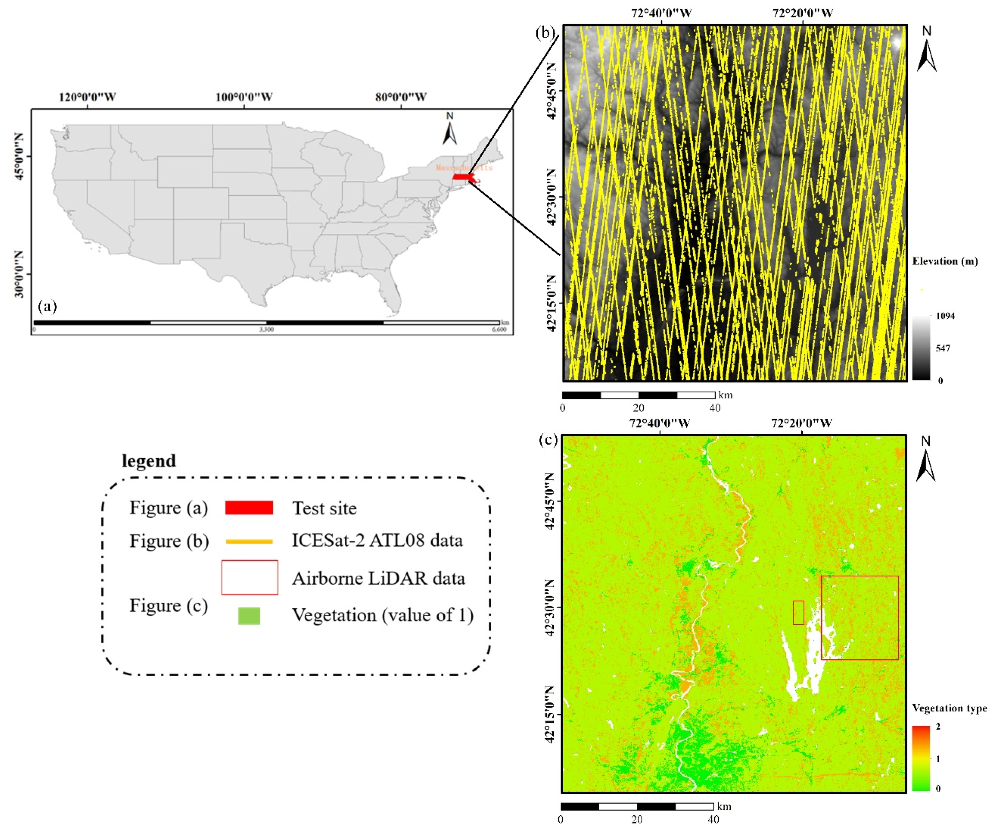
2.1. Test Site
2.2. SRTM DEM
2.3. ICESat-2 ATL08 Product (Version 5)
2.4. Vegetation Classification Data
2.5. Airborne LiDAR Data
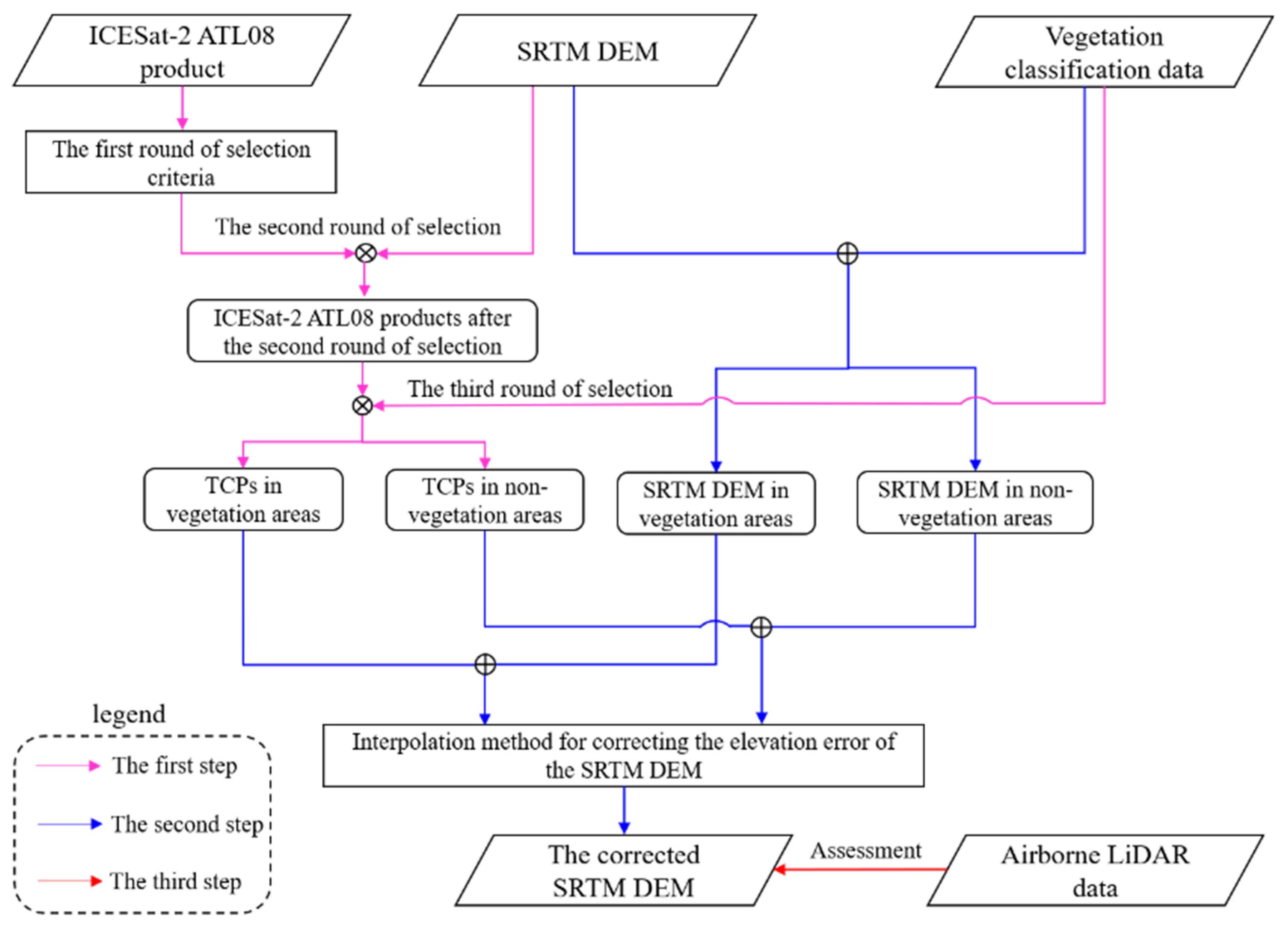
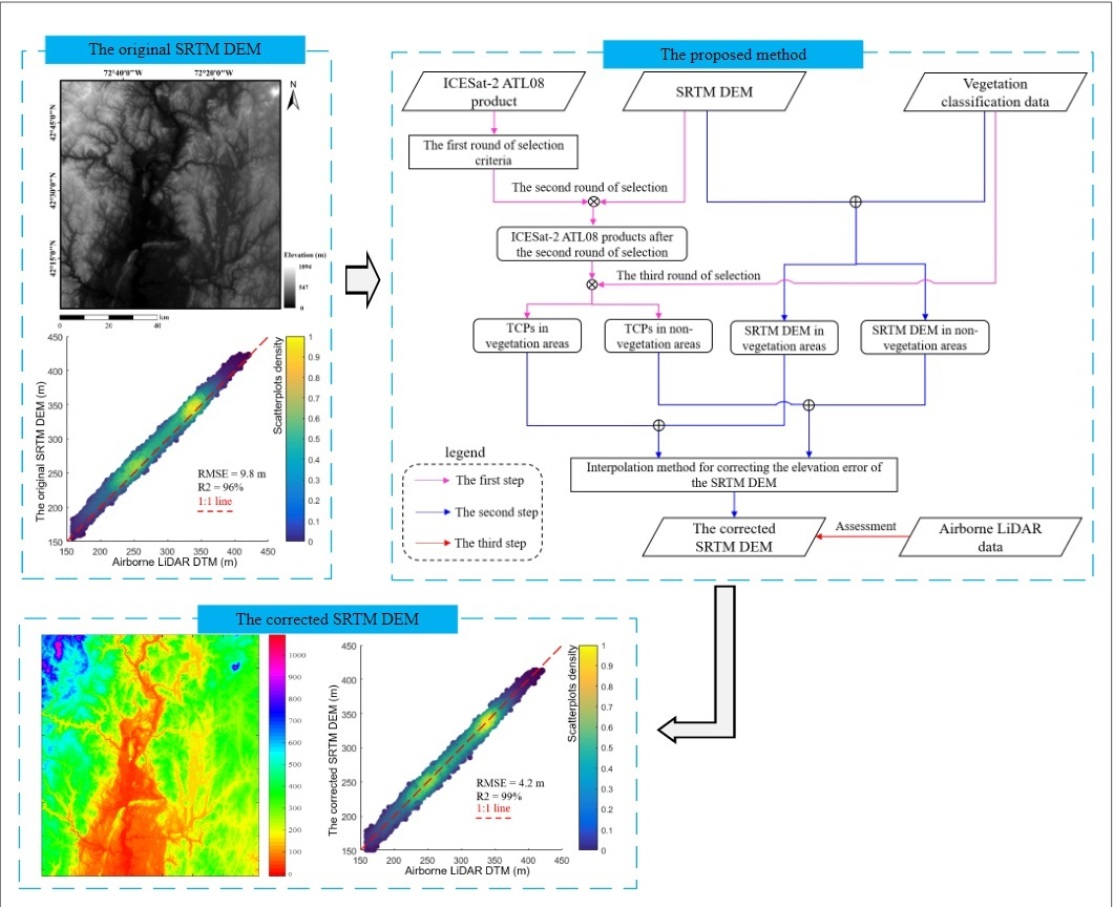
3. Methods
3.1. The ICESat-2 Terrain Control Points Selecting Criteria
3.2. Interpolating the Elevation Correction Surface of the SRTM DEM
3.3. Assessment
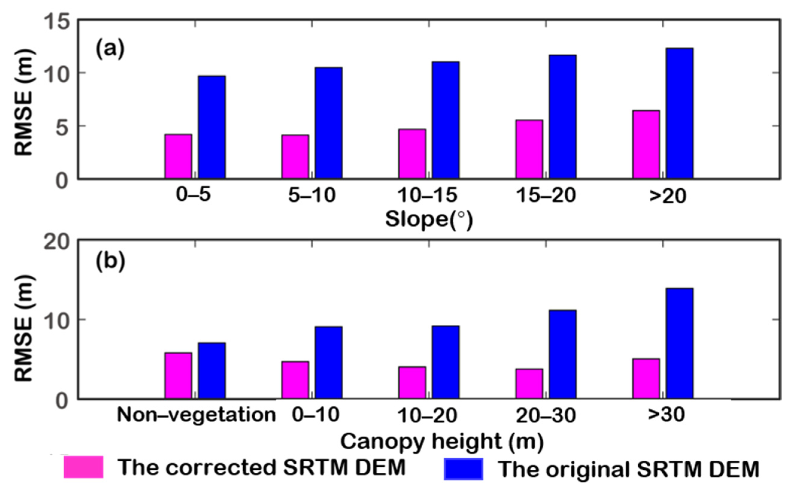
4. Results
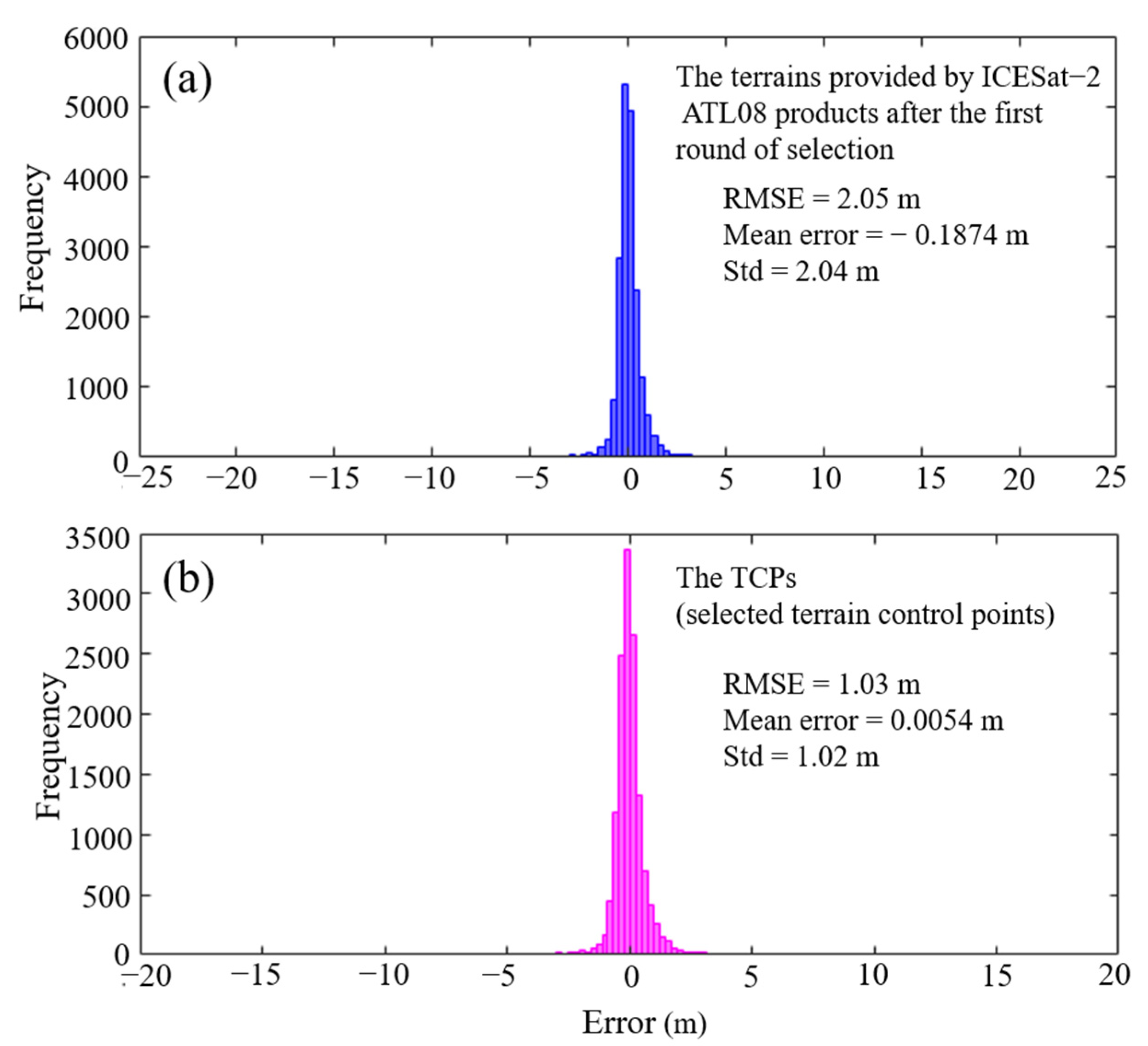
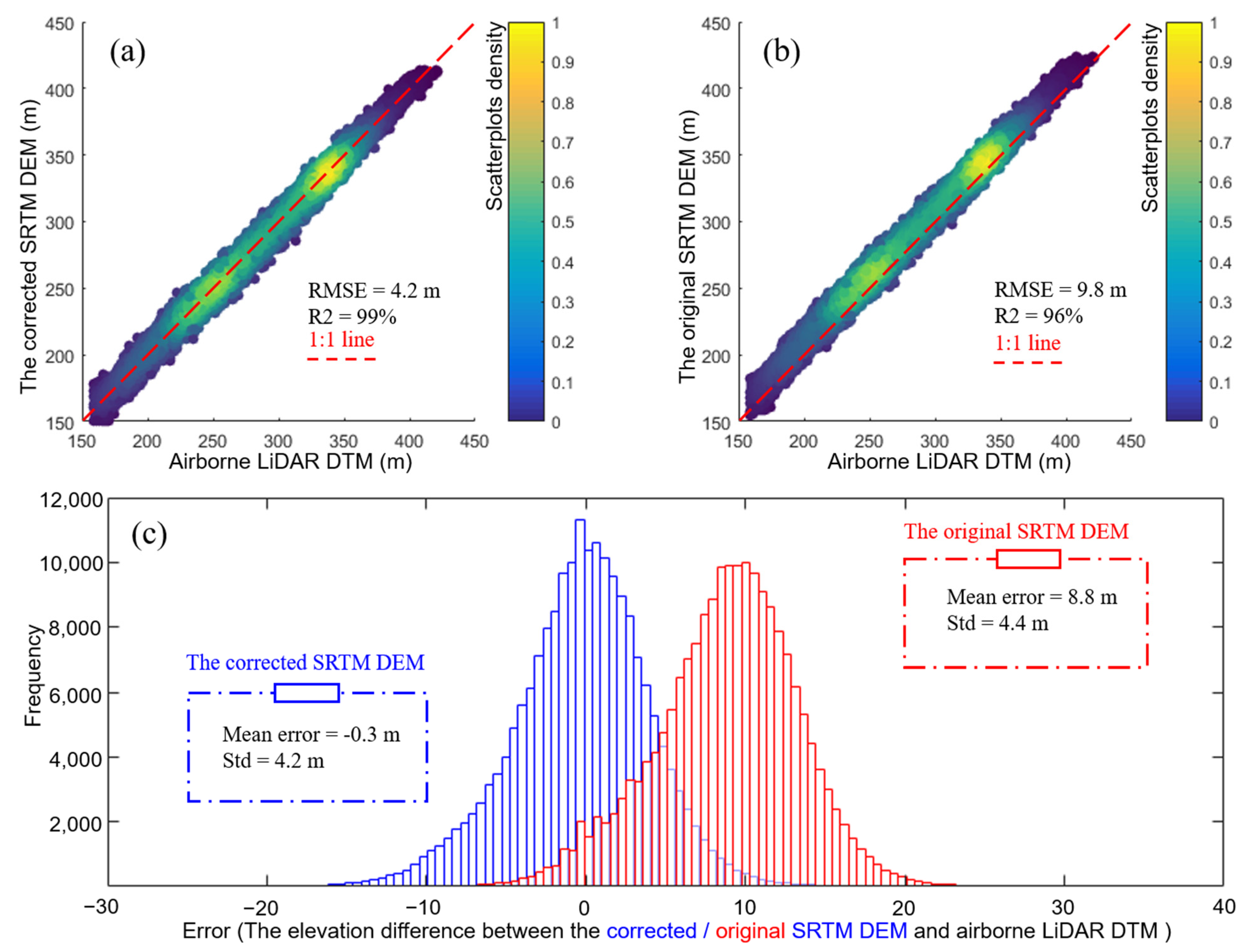
4.1. Accuracy of the TCPs
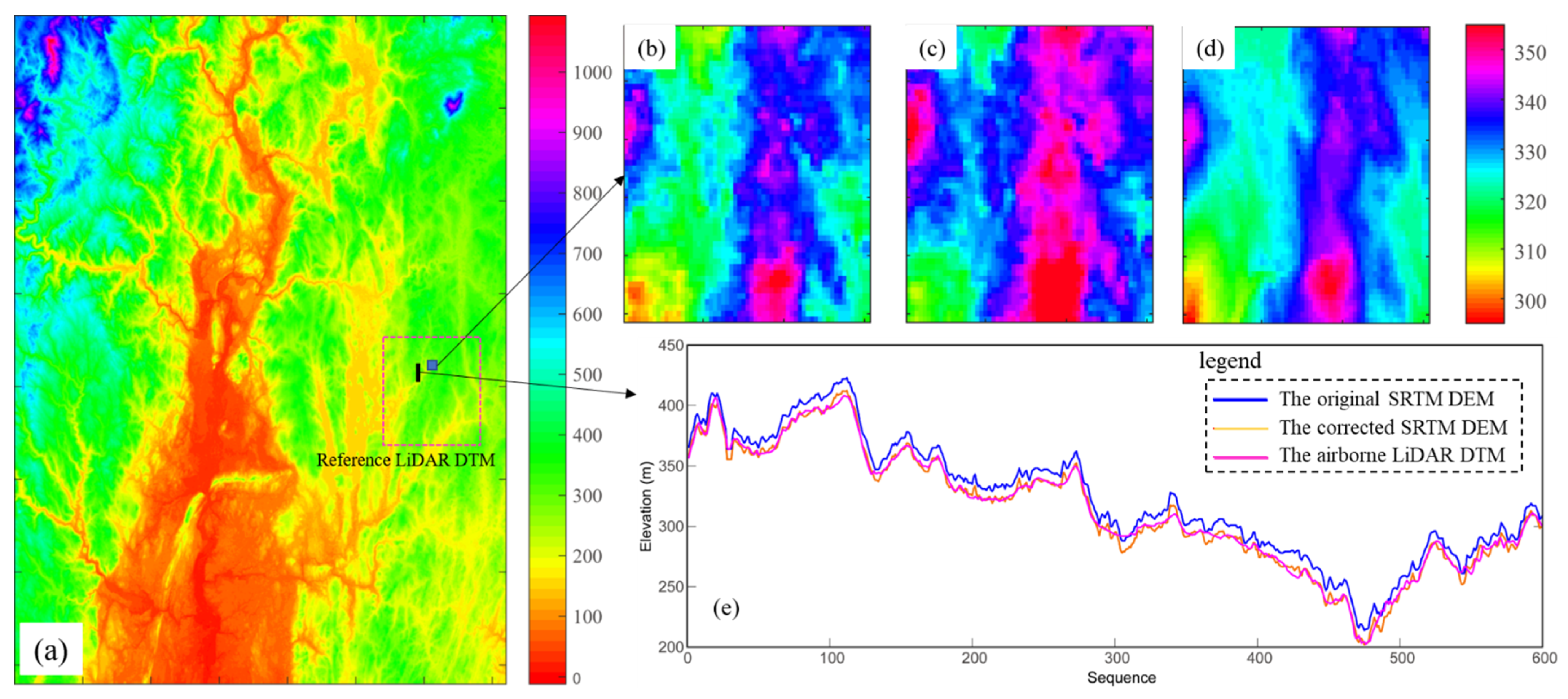
4.2. The Accuracy of the Corrected SRTM DEM
5. Discussion
6. Conclusions
Author Contributions
Funding
Data Availability Statement
Acknowledgments
Conflicts of Interest
References
- Sun, Q.; Zhang, L.; Ding, X.L.; Hu, J.; Li, Z.W.; Zhu, J.J. Slope deformation prior to Zhouqu, China landslide from InSAR time series analysis. Remote Sens. Environ. 2015, 156, 45–57. [Google Scholar] [CrossRef]
- Zhao, R.; Li, Z.W.; Feng, G.C.; Wang, Q.J.; Hu, J. Monitoring surface deformation over permafrost with an improved SBAS-InSAR algorithm: With emphasis on climatic factors modeling. Remote Sens. Environ. 2016, 184, 276–287. [Google Scholar] [CrossRef]
- Rajendran, S.; Nasir, S. ASTER capability in mapping of mineral resources of arid region: A review on mapping of mineral resources of the Sultanate of Oman. Ore Geol. Rev. 2019, 108, 33–53. [Google Scholar] [CrossRef]
- Rajendran, S.; Nasir, S.; El-Ghali, M.A.K.; Alzebdah, K.; Salim Al-Rajhi, A.; Al-Battashi, M. Spectral Signature Characterization and Remote Mapping of Oman Exotic Limestones for Industrial Rock Resource Assessment. Geosciences 2018, 8, 145. [Google Scholar] [CrossRef] [Green Version]
- Wang, Y.; Dong, P.; Liao, S.; Zhu, Y.; Zhang, D.; Yin, N. Urban Expansion Monitoring Based on the Digital Surface Model—A Case Study of the Beijing–Tianjin–Hebei Plain. Appl. Sci. 2022, 12, 5312. [Google Scholar] [CrossRef]
- Mcgowan, S.; Leavitt, P.R.; Hall, R.I.; Wolfe, B.B.; Edwards, T.; Karst-Riddoch, T.; Vardy, S.R. Interdecadal declines in flood frequency increase primary production in lakes of a northern river delta. Glob. Chang. Biol. 2011, 17, 1212–1224. [Google Scholar] [CrossRef]
- Ludwig, R.; Schneider, P. Validation of digital elevation models from SRTM X-SAR for applications in hydrologic modeling. ISPRS J. Photogramm. Remote Sens. 2006, 60, 339–358. [Google Scholar] [CrossRef]
- Lei, Y.; Paul, S. An Automatic Mosaicking Algorithm for the Generation of a Large-Scale Forest Height Map Using Spaceborne Repeat-Pass InSAR Correlation Magnitude. Remote Sens. 2015, 7, 5639–5659. [Google Scholar] [CrossRef] [Green Version]
- Steelman, T.A.; Maguire, L.A. Understanding participant perspectives: Q-methodology in national forest management. J. Policy Anal. Manag. 1999, 18, 361–388. [Google Scholar] [CrossRef]
- Farr, T.G.; Rosen, P.A.; Caro, E.; Crippen, R.; Duren, R.; Hensley, S.; Kobrick, M.; Paller, M.; Rodriguez, E.; Roth, L. The Shuttle Radar Topography Mission. Rev. Geophys. 2007, 45, 361. [Google Scholar] [CrossRef] [Green Version]
- Rabus, B.; Eineder, M.; Roth, A.; Bamler, R. The shuttle radar topography mission—A new class of digital elevation models acquired by spaceborne radar. ISPRS J. Photogramm. Remote Sens. 2003, 57, 241–262. [Google Scholar] [CrossRef]
- Falorni, G.; Teles, V.; Vivoni, E.R.; Bras, R.L.; Amaratunga, K.S. Analysis and characterization of the vertical accuracy of Digital Elevation Models from the Shuttle Radar Topography Mission. J. Geophys. Res. Atmos. 2005, 110, F02005. [Google Scholar] [CrossRef]
- Casu, F.; Manzo, M.; Lanari, R. A quantitative assessment of the SBAS algorithm performance for surface deformation retrieval from DInSAR data. Remote Sens. Environ. 2006, 102, 195–210. [Google Scholar] [CrossRef]
- Farr, T.G.; Kobrick, M. Shuttle radar topography mission produces a wealth of data. Eos Trans. Am. Geophys. Union 2013, 81, 583–585. [Google Scholar] [CrossRef]
- Su, Y.; Guo, Q.; Ma, Q.; Li, W. SRTM DEM Correction in Vegetated Mountain Areas through the Integration of Spaceborne LiDAR, Airborne LiDAR, and Optical Imagery. Remote Sens. 2015, 7, 11202–11225. [Google Scholar] [CrossRef] [Green Version]
- Su, Y.; Guo, Q. A practical method for SRTM DEM correction over vegetated mountain areas. ISPRS J. Photogramm. Remote Sens. 2014, 87, 216–228. [Google Scholar] [CrossRef]
- Zhao, X.; Su, Y.; Hu, T.; Chen, L.; Gao, S.; Wang, R.; Jin, S.; Guo, Q. A global corrected SRTM DEM product for vegetated areas. Remote Sens. Lett. 2018, 9, 393–402. [Google Scholar] [CrossRef]
- O’Loughlin, F.E.; Paiva, R.C.D.; Durand, M.; Alsdorf, D.E.; Bates, P.D. A multi-sensor approach towards a global vegetation corrected SRTM DEM product. Remote Sens. Environ. 2016, 182, 49–59. [Google Scholar] [CrossRef] [Green Version]
- Arefi, H.; Reinartz, P. Accuracy Enhancement of ASTER Global Digital Elevation Models Using ICESat Data. Remote Sens. 2011, 3, 1323–1343. [Google Scholar] [CrossRef] [Green Version]
- Neuenschwander, A.; Pitts, K. The ATL08 land and vegetation product for the ICESat-2 Mission. Remote Sens. Environ. 2019, 221, 247–259. [Google Scholar] [CrossRef]
- Li, Y.; Zhu, J.; Fu, H.; Gao, S.; Wang, C. Filtering Photon Cloud Data in Forested Areas Based on Elliptical Distance Parameters and Machine Learning Approach. Forests 2022, 13, 663. [Google Scholar] [CrossRef]
- Zhu, J.; Yang, P.; Li, Y.; Xie, Y.; Fu, H. Accuracy assessment of ICESat-2 ATL08 terrain estimates: A case study in Spain. J. Cent. South Univ. 2022, 29, 226–238. [Google Scholar] [CrossRef]
- Ice, Cloud, and Land Elevation Satellite-2(ICESat2) Algorithm Theoretical Basis Document (ATBD) for Land-Vegetation Along-Track Products (ATL08). pdf. Available online: https://icesat-2.gsfc.nasa.gov/science/data-products (accessed on 1 March 2022).
- Neuenschwander, A.; Guenther, E.; White, J.C.; Duncanson, L.; Montesano, P. Validation of ICESat-2 terrain and canopy heights in boreal forests. Remote Sens. Environ. 2020, 251, 112110. [Google Scholar] [CrossRef]
- Neuenschwander, A.L.; Magruder, L.A. Canopy and Terrain Height Retrievals with ICESat-2: A First Look. Remote Sens. 2019, 11, 1721. [Google Scholar] [CrossRef] [Green Version]
- Kampe, T.U.; Johnson, B.R.; Kuester, M.A.; Keller, M. NEON: The first continental-scale ecological observatory with airborne remote sensing of vegetation canopy biochemistry and structure. J. Appl. Remote Sens. 2010, 4, 043510. [Google Scholar] [CrossRef] [Green Version]
- Tobler, W.R. A Computer Movie Simulating Urban Growth in the Detroit Region. Econ. Geogr. 1970, 46, 234–240. [Google Scholar] [CrossRef]
- Kim, D.E.; Liu, J.; Liong, S.Y.; Gourbesville, P.; Strunz, G. Satellite DEM Improvement Using Multispectral Imagery and an Artificial Neural Network. Water 2021, 13, 1551. [Google Scholar] [CrossRef]


| Dataset | Resolution (m) | Coordinate System | Elevation Datum | Date (Year) |
|---|---|---|---|---|
| SRTM | 30 | WGS—84 | EGM96 | 2014 |
| ICESat-2 ATL08 (version 5) | 20 | WGS—84 | WGS—84 | 2018–2021 |
| Vegetation Classification data | 50 | WGS—84 | *** | 2014 |
| The reference LiDAR DTM and CHM | 1 | UTM | NAVD88 | 2019 |
| Number of the Terrain Points | RMSE (m) | Elevation Range (m) | ||||
|---|---|---|---|---|---|---|
| The original terrain points | 868,543 | *** | *** | |||
| The first round of selection | 571,514 | 2.05 | −300–1100 | |||
| The second round of selection | 452,268 | 1.03 | −30–1100 | |||
| The third round of selection | Veg | Non-Veg | Veg | Non-Veg | Veg | Non-Veg |
| 385,347 | 66,921 | 1.03 | 0.68 | −20–1000 | −30–1100 | |
Publisher’s Note: MDPI stays neutral with regard to jurisdictional claims in published maps and institutional affiliations. |
© 2022 by the authors. Licensee MDPI, Basel, Switzerland. This article is an open access article distributed under the terms and conditions of the Creative Commons Attribution (CC BY) license (https://creativecommons.org/licenses/by/4.0/).
Share and Cite
Li, Y.; Fu, H.; Zhu, J.; Wu, K.; Yang, P.; Wang, L.; Gao, S. A Method for SRTM DEM Elevation Error Correction in Forested Areas Using ICESat-2 Data and Vegetation Classification Data. Remote Sens. 2022, 14, 3380. https://doi.org/10.3390/rs14143380
Li Y, Fu H, Zhu J, Wu K, Yang P, Wang L, Gao S. A Method for SRTM DEM Elevation Error Correction in Forested Areas Using ICESat-2 Data and Vegetation Classification Data. Remote Sensing. 2022; 14(14):3380. https://doi.org/10.3390/rs14143380
Chicago/Turabian StyleLi, Yi, Haiqiang Fu, Jianjun Zhu, Kefu Wu, Panfeng Yang, Li Wang, and Shijuan Gao. 2022. "A Method for SRTM DEM Elevation Error Correction in Forested Areas Using ICESat-2 Data and Vegetation Classification Data" Remote Sensing 14, no. 14: 3380. https://doi.org/10.3390/rs14143380
APA StyleLi, Y., Fu, H., Zhu, J., Wu, K., Yang, P., Wang, L., & Gao, S. (2022). A Method for SRTM DEM Elevation Error Correction in Forested Areas Using ICESat-2 Data and Vegetation Classification Data. Remote Sensing, 14(14), 3380. https://doi.org/10.3390/rs14143380